Embed Size (px)
Citation preview
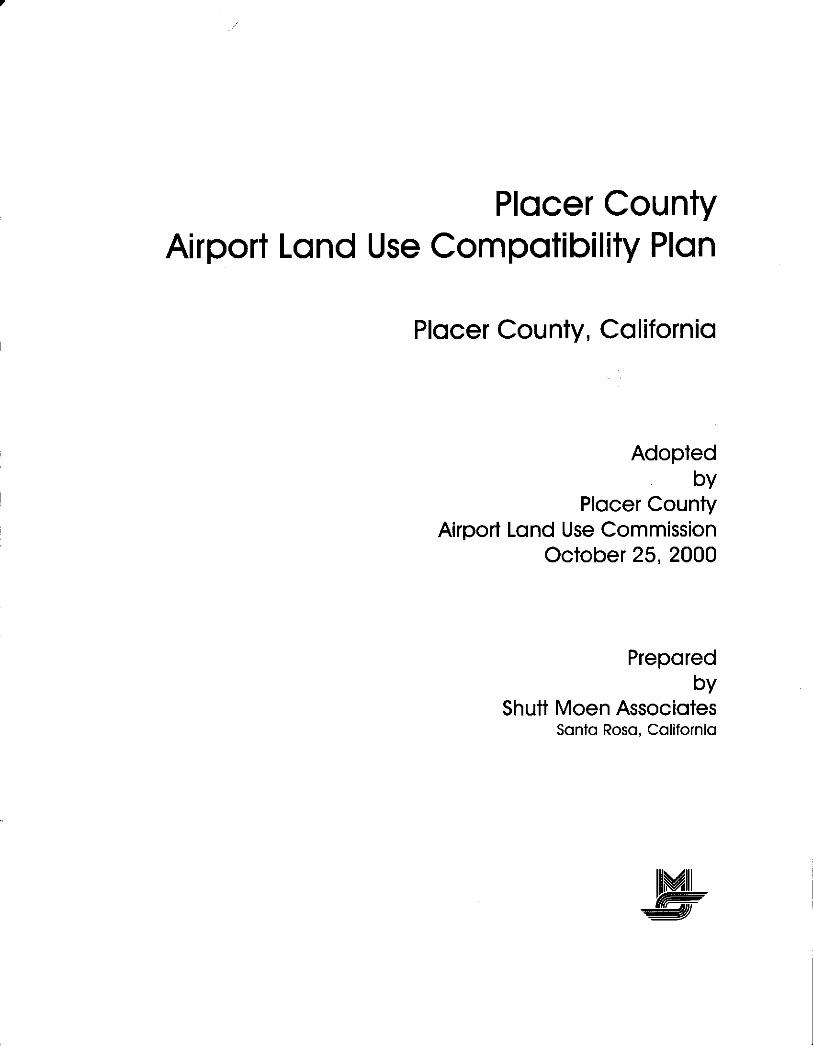
Plocer CountyAirporl Lqnd Use Compotibility Plon
Plocer Counfy, Colifornio
Adoptedby
Plocer CounfyAirporl Lond Use Commission
October 25. 2000
Preporedby
Shutt Moen AssociotesSonto Roso. Colifornio
iltMill'ffi==EJ

Placer County Transportation Planning Agency/Airport Land Use Commission
Board Members
Tom Cosgrove, Councilmember, City of LincolnHany Crabb, Mayor, City of Roseville
Roger Hollis, Councilmember, Town of LoomisRoger lmsdahl, Citizen RepresentativeKathy Lund, Councilmember, City of RocklinScott Perry, (Vice Chair) Mayor, City of ColfaxKathy Sands, (Chair) Councilmember, City of Auburn
Harriet White, Supervisor, Placer County
Jim Williams, Supervisor, Placer County
Staff
Celia McAdam, Executive DirectorKathryn Mathews, Senior Transportation Planner
Linda Aeschliman, Senior Transportation Planner

Date ot Application
Property Owner
Mailing Address
Phone Number
Agent (if any)
Mailing Address
Phone Number
Address
essor's Parcel No.
division Name
Number
Parcel Size
ZoningClassitication
FP]S!:r:,:::i,j,r,rrti
bsr:(tP.e;'.'i1cL
Existing Land Use(describe)
Proposed Land Use
For Residential Uses Number of Parcels or Units on Site (incl. secondary units)
For Other Land Uses Hours of Use
Numberof MaximumNumberPeoPle Method of calculationon Site...
Height Data Height above Ground oI Tallest Object (including antennas & trees)
Hiqhest Elevation (above sea level) of Any Object or Terrain on Site tt.
Does the project involve any characteristics which could create electrical
interference, confusing lights, glare, smoke, or other electrical or visual
hazards to aircraft flight?
lf ves. describe
tr Yes
trFlight Hazards
No
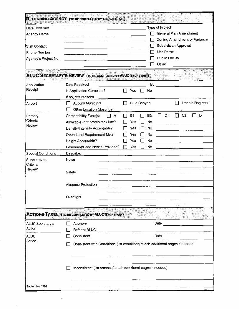

Table of Contents
INTRODUCTION
AIRPoRT LAND USE COMPATIBILITY PIANNINC
Function and Applicability of the Plan
Statutory RequirementsPowers and DutiesLimitations
Placer County Airport Land Use Commission
Relationship of ALUC to County and City Covernments . .
PLAN PREPARATION AND REVIEW
State CuidelinesRelationship to Airport Master Plans . . .
Plan Review and Adoption Process .
PLAN IMPIEMENTATION ...Ceneral Plan ConsistencyAirport Combining Zone ConceptProject Referrals
PL{NCoNTENTS...
COUNT}WIDE POTICIES
2.
'1 .
3.
CLNTRAL APPI ICABIL Iry . . . .
1.1. Purpose .
1.2. DefiniLions
1.3. Geographic Scope . .
1.4. Types of Airport lmpac6 .
1.5. Types of Actions Reviewed
RTVIEWOI L{ND USIACIIO\S ......2.1. General .
2.2. Review Process for Community Land Use Plans and Ordinances . . .
2.3. Review Process for Major Land Use Actions .
2.4. Review Criteria for Land Use Actions .
REVIEW oF AIRPORT MASTER PLANS AND DEVELOPMENT PLANS , .
3.1. Review Process
3.2. Review Criteria for Master or Development Plans of Existing Airports
3.3. Review Criteria for Proposed New Airports or Heliports
4. SUPPoRIINC COMPATIBILITY CRITERIA
4,1. Noise ,.4.2. Safety . .
4.3. Airspace Protection ......4.4. Overflights
1 -'.I
1-111
t-.]
1-41-41-4
1-6t-o1-61-B
1-81-8
')1
. 2-8
. 2-B
. 2-B
2-102-122-182,182-192-202-21
2-212-24
2-282-30

Table ot Contents
INDIVIDUAT AIRPORT POTICIES AND COMPAT]BITITY MAPS
1 , BASIS FOR COMPATIBILIry ZONE BOUNDARIES
1 .1 . Ceneral .
1,2. Special Conditions .
2.
3.
4.
AUBURN ML \ICIPAI AIRPOR I
?.1 . Compatibility Map Delineation2.2. Additional Compatibility Policies
BLL T CANYON AIRPORI .,.3.1. Compatibility Map Delineation3.2. Addltional Compatibility Policies
LI\COI \ RI CIONAL AIRPORT
4.1. Compatibility Map Delineation4.2. Additional Compatibility Policies
BACKGROUND DATA: AUBURN MUNICIPAT AIRPORT
. 3-3
. 3-4
.3-5
. 3-6
. 3-6
. 3-6
. 3-B
. 3-8
. 3-9
l\TRoDUCTtoN
Exhibit 4A: Airport Features InformationExhibit48: Airport Layoul Plan ........txhibit 4C: Airspace Plan . . .
Exhibit4D: AirportActivityData .......txh ibit 4E: Noise lmpacts
Exhibit 4F: Airport Environs InformationExhibit 4C: Planned Airport Vicinity Land
Exhibit 4H: Compatibility Factors MapUSCS
. 4-1
ff 4-2ff 4-2. 4-4. 4-5
. 4-6ff 4-6ff 4-6
-- -l-l
....5-2
..lIs-2
.. ff s-2
.... 5-4
....5-6
. rT 5 -t)
BACKCROUND DATA: BLUE CANYON AIRPORT
Exhibit 5B: Airport Layout Plan
Exhibit 5C: Airspace Plan . . . .
Exhibit 5D: Airport Activity Data
Lxhibit :[: Noise lmpacts
Exhibit 5F: Airport Environs Information , . . ,
Exhibit 5G: Planned Airport Vicinity Land Uses

BACKGROUND DATA: UNCOIN REGIONAL AIRPORT
l\TRoDUc r ro\Exhibit 64: Airport Features Information . .
Exhibit68: Airport Layout Plan .. .... .. .
E\hibit 6C: Airspace Plan . . .
Exhibit6D: Airport Activity Data ........Exhibit 6E: Noise lmpactsExhibit 6F: Airport Environs Information . . . .
Exhibit 6C: Planned Airport Vicinity Land Uses
Exhibit 6H: Compatibility Factors Map . . . . .
APPENDICES
B
C
D
E
F
U
H
I
State Laws Related to Airport Land Use Planning
Federal Aviation Regulations Part 77
Methods for Deternrining Concentrations of People
Compatibility Cuidelines for Specific Land Uses
Project Referral Form
Sample lmplementation Documents
Comparison Betvveen New and Old ALUC Plans
Local Plans Consistency Review
Clossary of Terms
ATTACHMENTS
) Caltrans Aeronautics Program Approval of Blue Canyon Airport Layout Plan
> CEQA Notice of Exemption
LIST OF TABLES AND FIGURIS
Tables
o-l
6-2ff 6-2ff 6-2. 6-4. 6-5. 6-6ff 6,6ff 6-6
2A2B
Figures
3A3B
3C
Primary Compatibility CriteriaNoise Compatibility Criteria .
Auburn Municipal Airport Compatibility MapBlue Canyon Airport Compatibility MapLincoln Regional Airport Compatibility Map
2-162-23
ff 3-4ff 3-6tf 3-B
l

trg@

lntroduction
ArRponr LlNo Usr CoMplnstltrv Pururutruc
Function and Applicability of the Plan
The basic function of this Placer County Airport Land Use Compatibility Plan is to promote compati-
bility between the airports in Placer County and the land uses which surround them. As adopted by
the Placer County Airport Land Use Commission, the plan serves as a tool for use by the commission
in fulfilling its duty to review airport and adjacent land use development proposals. Additionally, the
plan sets compatibility criteria applicable to local agencies in their preparation or amendment of land
use plans and ordinances and to land owners in their design of new development.
The plan is primarily concerned with land uses near the three public-use airports in Placer County:
' Auburn Municipal Airport
' Blue Canyon Airport
' Lincoln Regional Airport
(Note: This plan does not address Truckee-Tahoe Airport. Airport land use compatibility planning
matters for that airport, which lies on the boundary beMeen Placer and Nevada counties, are the
responsibility of the Foothill Airport Land Use Commission.)
The influence area for each of the airports, as defined herein, extends roughly 2 to 3 miles from the
airport runways. These influence areas encompass lands within three local government jurisdictions
in Placer County:
' County of Placer
' City of Auburn
' City of Lincoln
Additionally, portions of the Elue Canyon Airport influence area affect lands within the jurisdiction of
two other government entities: the county of Nevada and the U.S. Forest Service. Although the

t ntroduction I Chapter 1
authority of the Placer County Airport Land Use Commission does not extend to these jurisdictions,
policies in rhe Compatibility P/an address the importance of coordination on airport land use com-
oatibilitv matters.
Details regarding the purpose, scope, and applicability of the Compatibility PIan are set forth in the
tvvo policy chapters which follow.
Statutory Requirements
Powers and Duties
Requirements for creation of airport land use commissions (ALUCs) were first established under the
California State Aeronautics Act (Public Utility Code Sections 21620 et seq.) in 1962. Although the
law has been amended numerous times since then, the fundamental purpose ofALUCs to promote
land use compatibility around airports has remained unchanged. fu expressed in the present stat-
utes, th is purpose is:
"...to protect public health, safety, and welfare by ensuring the orderly expansion of airports
and the adoption of land use measures that minimize the public's exposure to excessive
noise and safety hazards within areas around public airports to the extent that these areas are
not already devoted to incompatible uses."
The statutes give ALUCs two principal powers by which to accomplish this objective. First, ALUCs
must prepare and adopt an airport land use plan. Secondly, they must review the plans, regulations,
and other actions of local agencies and airport operators for consistency with that plan.
Limitations
Also explicit in the statutes are two limitations on the powers of ALUCs. Specifically, ALUCs have no
authority over existing land uses (Section 2167 4(a)\ or over the operation of airports (Section
21674(e)). Neither ofthese terms is defined within the statutes, although the interpretation oftheirmeaning is fairly standard throughout the state.
) Existing Land Uses - The precise wording of the Aeronautics Act is that the authority of ALUCs
extends only to land in the vicinity of airports which is "not already devoted to incompatible
uses," The working interpretation of ihis language is that ALUCs have no state-empowered au-
thority over existing land uses. The question then becomes one of determining what conditions
qualify a land use as existing.
For airport land use planning purposes, a land use can generally be considered existing once the
local agency has completed all discretionary actions on the project and only ministerial approvals
remain. A vacant property thus can be considered "devoted to" a pafticular use, even if the
activity has not begun, once local government commitments along with substantial construction

investments by the property owner make it infeasible for the property to be used for anything
other than its proposed use. Local government commitment to a proposal can usually be consid-
ered firm once a vesting tentative map, development agreement, or other land use entitlement
has been approved.
) Operation of Airports - Any actions pertaining to how and where aircraft operate on the
ground or in the air around an airport are clearly not within the jurisdiction of ALUCs to regulate.
ALUC involvement with aircraft operations is limited to taking the operational characteristics into
account in the development of land use compatibility plans. This limitation on the jurisdiction of
ALUCs cannot, however, be taken to mean that they have no authority with respect to new de-
velopment on airport property. For example, the law specifically requires ALUCs to review pro-
posed airport master plans for consistency with the commission's plans. ALUCs also are generally
conceded to have authority to review proposals for nonaviation development on airport proper-
ty.
A third, less absolute, limitation concerns the types of land use actions which are subject to ALUC
review. The current law emphasizes local general plans as the primary mechanism for implementing
the compatibility policies set forth in an ALUC's plan. Thus, the county and each affected city is re-
quired to make its general plan consistent with the ALUC plan (or to override the commission).
Once a local agency has taken this action to the satisfaction of the Airport Land Use Commission, the
ALUC's authority to review pro.iects within that jurisdiction is narrowly limited. The only actions for
which review remains mandatory are proposed adoption or amendment of general plans, specific
plans, zoning ordinances, and building regulations affecting land within an airport influence area.
For an ALUC to review individual projects, the local agency must agree to submit them.
Placer County Airport Land Use Commission
State law provides two basic options regarding the structure of airport land use commissions: a stan-
dard format or designation of an existing body to serve as the ALUC. Among California's 58 coun-
ties, these two formats are used in roughly equal proportions.
Membership on ALUCs structured in the standard manner is specified to be as follows:
' Two members appointed by the county board of supervisors;
' Two members appointed by a selection committee of mayors of the county's cities;
' Two members appointed by airport managers; and
' A seventh member, representing the general public, appointed by the other six.
The designated body format has several possibilities. Most common is for a single- or multi-county
councii of governments or similar entity to be designated astheALUC. This isthe arrangement es-
tablished in Placer County where the Placer County Transpoftaiion Planning Agency functions as the
airport land use commission. Other types of bodies which serve as ALUCs in some counties include
the county planning commission, the county airport commission, or the county board of supervisors.
| -\t

An airport land use commission was first established for Placer County in 1985. Initially, the Sierra
Planning Organization (SPO) - a four-county council of governments and economic development
agency consisting of El Dorado, Nevada, Placer, and Sierra counties and most of the cities within
them - functioned as the ALUC. In its ALUC role, SPO operated under the name "Foothill Airport
Land Use Commission."
At the urging of Placer County and the cities of Auburn and Lincoln, the Placer County Transporta-
tion Planning Agency (PCTPA) assumed the ALUC responsibility in January 1997. The desire for
greater local control over airport land use planning matters was the principal factor which prompted
the change in designation. PCTPA already had certain cou ntywide airport planning d uties as the
designated regional transportation planning agency for all of Placer County except the Tahoe Basin.
Moreover, the governing board of PCTPA consists of elected officials from the three airport-owning
entities in the county along with representatives from the four other cities in the county.
The PCTPA Executive Director serves as the ALUC secretary with support from the agency staff.
Relationship of ALUC to County and City Covernments
The fundamental relationship between the Placer County Airport Land Use Commission and the
governments of Placer County and the cities affected by the Compatibility Plan is set by the State
Aeronautics Act. The ALUC is not simply an advisory body for the Board of Supervisors or city coun-
cils in the manner that their respective planning commissions are. Rather, it is more equivalent to
the Placer County Local Agency Formation Commission (LAFCo). Within the bounds defined by
state law, the decisions of the ALUC are final and are independent of the county Board of Supervi-
sors or city councils. The ALUC does not need county or city approval in order to adopt this Com-
patibility Plan or to carry out ALUC land use project review responsibilities.
Pun PRrpnnnnoN AND Rrvlrw
State Guidelines
Subsequent to establishment of the Foothill Airport Land Use Commission, arrangements were made
with the Sacramento Area Council of Covernments (SACOC) to prepare airport land use compatibil-
ity plans for the Auburn and Lincoln airports. (SACOG serves as the ALUC for Sacramento, Sutter,
Yolo, and Yuba counties). The Lincoln Municipal Airpon Comprehensive Land Use P/an was adopted
in October 'f 986. TheAuburn Airport Comprehensive Land Use Plan was adopted in February 1987
and amended later. No previous plan has been prepared for Blue Canyon Airport.
These plans served their intended function while Placer County remained part of the Foothill ALUC
and they have remained in effect with the transfer of ALUC responsibilities to the Placer County

Intrcduction I ChaDter 1
Transportation Planning Agency. However, asthe newALUC for Placer County, PCTPA determined
that a thorough review and update of the plans was needed. lt is the intentthatthe original plans be
superseded with adoption of the new Airpo rt Land lJse Compatibility Plan represented by this docu-
ment.
Major influences on the decision to prepare a new Compatibility PIan were the Caltrans Aeronautics
Program's issuance of the 1993 Airpoft Land Use Planning Handbook and the legislature's enactment
of two new faws pertaining to the Handbook. A 1994 state law requires ALUCs to be "guided by"
information in the Handbook when formulating or amending compatibility plans. Another statute
enacted in the same year creates a tie between lhe Handbook and California Environmental QualityAct (CEQA) documents. Lead agencies now must use the Handbook as "a technical resource" when
assessing airport-related noise and safety impacts of projects located in the vicinity of airports. The
Handbook provides extensive guidance on preparation and content of compatibility plans, on proce-
dures for ALUC review of local actions, and on the responsibilities of local agencies. The second half
of the document contains background information regarding noise and safety compatibility concepts,
including valuable, not previously available, data regarding general aviation aircraft accident location
patterns and other characteristics.
Relationship to Airport Master Plans
Airport land use compatibility plans are distinct from airport master plans in function and content. In
simple terms, the issues addressed by airport master plans are primarily on-airport whereas those ofconcern in a compatibility plan are off-airport. The purpose of airport master plans is to assess the
demand for airport facilities and to guide the development necessary to meet those demands. An
airport master plan is prepared for and adopted by the agency which owns and/or operates the air-
port. In contrast, the purpose of compatibility plans is to assure that incompatible development does
not occur on lands surrounding the airports. The responsibility for preparation and adoption of com-patibility plans lies with each county's airport land use commission.
This distinction notwithstanding, the relationship between the two types of plans is close. Specifi-
cally, Section 2167 5(a) of the state law requires that ALUC plans be based upon a long-range airport
master plan adopted by the airport owner/proprietor. lf such a plan does not exist for a particular
airport, an airport layout plan may be used subject to approval by the Caltrans Aeronautics Program.
The airport plan status differs for each of the three airports in Placer County:
) Auburn Municipal Airport - An airport master plan was adopted by the city in 1996. This plan
- and especially the activity forecasts, noise contours, and proposed facility improvements de-
scribed within it - was utilized as a maior input to the Auburn Municipal Airport policies includ-
ed in the Placer County Airport Land Use Compatibility PIan.
) Blue Canyon Airport - No master plan or layout plan has previously been prepared for this
low-activity airport. An airport layout plan was therefore prepared in conjunction with the Com-

patibility Plan study. The drawing shows onlyexisting facilities; no improvements are shown or
currently contemplated. The Blue Canyon Airport layout plan was approved by the Caltrans
Aeronautics Program for the purposes of this Compatibility Plan. (See letter attached at back of
this document.)
Lincoln Regional Airport - No recent master plan has been prepared for Lincoln Regional Arr-
port. However, an airport layout plan was adopted by the city of Lincoln early in 1999. The
contemplated future development shown on the drawing - particularly the long-range plans forconstruction of a parallel runway - is taken into account in the Compatibility Plan.
Plan Review and Adoption Process
Preparation of the P/acer County Airport Land Use Compatibility Plan was closely coordinated with
the three affected jurisdictions through a Plan Advisory Committee comprised of public works, plan-
ning, and airport staff representatives of those jurisdictions. AnAd Hoc Subcommittee of theALUCalso contributed with regard to several key policy decisions.
A draft plan dated September 1999 was widely circulated for local agency and general public review
and comment. Public workshops on the plan were held in Auburn and Lincoln in October 1999 and
again in September 2000. Both sets of workshops were publicized by means of block advertise-
ments in local papers. Additionally, for the second set of workshops, individual notices were sent to
approximately 5,000 owners of property in the three airport influence areas. Duringthis interval,
individual meetings also were held with several affected property owners and the staffs of the three
local .jurisdictions. Numerous revisions to the d raft plan were made in response to the comments
received.
The Placer County Airport Land Use Commission held a formal public hearing on the plan in May
2000. Aiter consideration of comments offered at the hearing at the second set of public work-shops, and in writing, a final set of revisions to the d raft plan was prepared. The Commission then
adopted the draft plan and accompanying addendum on October 25,2OOO. At that time, the Com-
mission also acted to find that the Compatibility Plan is categorically exempt from the California Envi-
ronmental Quality Act (CEQA). The present document incorporates all approved revisions. A copy
of the Notice of Exemption is included as an attachment at the back of the document.
PtAN IMPTEMENTATION
General Plan Consistency
As noted above, state law requires each local agency having jurisdiction over land uses within an
ALUC's planning area to modify its general plan and any affected specific plans to be consistent with
1-6

the compatibility plan. The local agency must take th is action within 1 80 days of when the ALUC
adopts or amends its plan. The only other course of action available to local agencies is to override
the ALUC by a two-thirds vote after first holding a public hearing and making findings that the
agency's plans are consistent with the intent of state law.
A general plan does not need to be identical with the ALUC plan in order to be consistent with it.
To meet the consistency test, a general plan must do two things:
' lt must specifically address compatibility planning issues, either directly or through reference
to a zoning ordinance or other policy document; and> lt must avoid direct conflicts with compatibility planning criteria.
Many community general plans pay little attention to the noise and safety factors associated with air-
port land use compatibility. Also, some of the designated land uses of property near an airport fre-
quently are contrary to good compatibility planning. lt is anticipated that each of theland use juris-
dictions affected by this Compatibility Plan will need to make some modification to its general plan
and/or other land use policy documents in order to meet the plan consistency requirements.
[An initial assessment of the consistency between the current local general plans and the policies set
forth in this ALUC Compatibility Plan is contained in Appendix H herein.l
Compatibility planning issues can be reflected in a general plan in several ways:
D Incorporate Policies into Existing General Plan Elements - One method of achievingthe nec-
essary planning consistency is to modify existing general plan elements. For example, airport
land use noise policies could be inserted into the noise element, safety policies could be placed
into a safety element, and the primary compatibility criteria and associated maps plus the proce-
dural policies might fit into the land use element. With this approach, the majority of the Com-
patibility P/an policies would be fully incorporated into a local jurisdiction's general plan.
> Adopt a General Plan Airport Element - Another approach is to prepare a separate airport ele-
ment of the general plan. Such a format may be advantageous when a community's general plan
also needsto address on-airport development and operational issues, Modification of other plan
elements to provide cross referencing and eliminate conflicts would still be necessary.
> Adopt Compatibility Plan as Stand-Alone Document - Jurisdictions selecting this optionwould simply adopt as a local policy document the relevant portions of the Compatibility Plan
specifically, Chapter 2 and the applicable airport policies and maps from Chapter 3, plus any
background information they wish to include. Changes to the community's existing general plan
would be minimal. Policy reference to the separate Compatibility P/an document would need to
be added and any direct land use or other conflicts with compatibility planning criteria would
have to be removed. Limited discussion of compatibility planning issues could be included in
the general plan, but the substance of most compatibility policies would appear only in the Com-
patibility Plan.

lntrcduction I ChaDter 1
l lmplementing Compatibility Policies Solely through Zoning - This approach is similar to the
one above except that the local jurisdiction would not explicitly adopt the Compatibility Plan as
policy. lnstead, the compatibility policies would be restructured either as an airport combining
zone ordinance or otherwise incorporated into the criteria specified for regular land use zone
districts. lmplementation of the compatibility policies would be solely through the zoning ordi-
nance. Policy reference to airport compatibility in the general plan could be as simple as men-
tioning support for the airport land use commission and stating that policy implementation is by
means of the combining zone.
Airport Combining Zone Concept
One mechanism avallable to local lurisdictions to implement various airport land use compatibility
criteria and review procedures is to adopt an airport combining zone ordinance. A combining zone
seryes as an overlay of standard community-wide land use zones and modifies or limits the uses per-
mitted by the underlying zone. Flood hazard combiningzoning is a common example. An airport
combining zone ordinance can serve as a convenient means of bringing various airport compatibility
criteria into one place.
Airport-related height limit zoning ordinances adopted by the affected Placer County jurisdictions
can serve as a starting point for an airport combining zone ordinance. Other components necessary
to fully implement ALUC plan policies - structural sound attenuation requirements and provisions
for a buyer awareness program, for example - could be added. (An outline of topics which could
be addressed in an airport combining zone is included in Appendix F,)
Project Referrals
In addition to the types of land use actions for which referral to the ALUC is mandatory in accor-
dance with state law, the Compatibility P/an specifies other land use projecs which either must or
should be submitted for review. Ihese major land use actions are defined in Chapter 2. Beginning
with when this plan is adopted and until such time as local jurisdictions have made the necessary
modifications to their general plans, all of these major land use actions are to be submitted to the
commission for review. After local agencies have made their general plans consistent with the Com-
patibility PIan,lhe ALUC requests that these ma.ior actions continue to be submitted on a voluntary
basis.
PHn CoNrrnrs
The most important components of this plan are found in Chapters 2 and 3. Chapter 2 presents air-
port compatibility and review policies applicable countpvide. Chapter 3 contains the compatibility
map for each airport together with individual policies and some explanatory notes for that airport.
'I -8
The remainder of the document constitutes supporting material. Chapters 4 through 6 contain back-
ground information regarding each of the airports in alphabetical sequence. The appendices provide
other information related to airport land use planning in general and airport land use commissions in
oarticular.

.lt
tr@@

Countywide Policies
1 . CENERAT Applrclerr-rrY
1 ,'l . Purpose
The purpose of this P/acer Cou nty Airport Land Use Compatibility Plan is to establish pro-cedures and criteria by which, in accordance with the California State Aeronautics Act:
1.1.1. Placer Countv Airport Land Use Commission (AIUC) - Ihe ALUC:
(a) Shall review proposed land use development in Placer County for compatibil-ity with airport activity.
(b) Shall review certain types of airport development proposals which are also
subject to ALUC review and are addressed by the P/an.
1.1.2. County of Placer and Affected Aties in the County - The county and cities:
(a) Shall refer specified land use proposals to the ALUC for review.
(b) Shall each make thei Ceneral Plan and zoning ordinance consistent with theCommission's Com patibility Pl an.
(c) Can make other planning decisions regarding the lands impacted by airportoperations.
1.1.3. County of Nevada - The county of Nevada can coordinate with the Placer
County ALUC and the county of Placer regarding airport impacs (specifically
with regard to Blue Canyon Airport) which overlap the common boundary be-tween the counties.
2-1

Countwide Policies I Chapter 2
1.2. Definitions
The following definitions apply for the purposes of the policies set forth in this document(additional terms are defined in the C/ossary):
1.2.1 . Aeronautics Act - Except as indicated otherwise, the article ofthe California
Public Utilities Code (Sections 21670 et seq.) pertainin8 to airport land use com-missions.
1.2.2. Airport - The Auburn Municipal Airport, Blue Canyon Airport, Lincoln Regional
Airport, or any other new public-use airport which might be created within the
boundaries of Placer Countv.
1 .2.3. Nrport lnfluence Area - An area, as delineated herein, which is routinely affecred by aircraft operations at an airport and within which certain land use actions
are sub ject to ALUC review.
1 .2.4. Airport Land Use Commission (ALUO -f he Placer County Airport Land Use
Commission.
1.2.5. Avigation fasernent - An easement which conveys rights associated with aircraft
overflight of a property, including creation of noise, Iimits on the height of struc-
tures and trees, etc. (see G/ossary)
1 .2.6. Community Noise Equivalent Level (CNEL) - The noise metric adopted by the
state of California for evaluating airport noise impacts. The noise impacts are typ-ically depicted by a set of contours, each of which represents points having thesame CNEL value.
1.2.7. Compatibility P/an - This document, the Placer County Airport Land Use Com-
Datibilitv Plan.
1.2.8. Compatibility Zone - Any of the zones set forth herein for the purposes of as-
sessing land use compatibility within the airport influence area.
1 .2.9. Existing Land Use - A land use wh ich either physically exists or for which local
government commitments along with substantial construction investment by theproperty owner make it infeasible for the property to be used for anything other
than its proposed use. Local government commitment to a proposal can usually
be considered firm once a vesting tentative map, development agreement, orother land use entitlement has been approved or all discretionary approvals have
been made.
2-2

Counwide Poticies / Chapter 2
1 .2.10. Federal Aviation Regulations (FAN Pari 77 -The
part of Federal Aviation Regula-
tions which deals with objects affecting navigable airspace in the vicinity of air-
ports. Objects which exceed the Part77 height limits constitute airspace ob-structions.
1.2.11. Height Review Over!ay Zone - Areas of land in the vicinity of an airport wherethe ground lies above anFARTT surface or less than 35 feet beneath such sur-
face.
1.2.12. Heliport - A helicopter landing facility for which a Heliport Permit is requiredfrom the California Department of Transportation. Public-use and special-use
heliports (including those at hospitals) are included within this definition, but heli-
pads located on an airport are excluded.
1.2.13. Local lurisdiction - The county of Placer or any city or other government agency(except agencies of the state or federal government) having .jurisd iction over land
uses within their boundaries.
1.2.14. Major Land Use Action - Actions related to proposed land uses for which com-patibility with airport activity is a particular concern, but for which ALUC reviewis not always mandatory under state law. These types of actions are listed in Pot-
icy 1 .5.3.
1.2.15. Nonconforming Use - ln general, a land use, parcel, or building which does notcomply with a current land use plan or zoning ordinance, but which was legally
permitted at the time the plan or ordinance was adopted. For the purposes ofthis Compatibility P/an, a nonconforming land use is one which exists (see definr-tion of "existing land use" in Policy 1.2.9) as ofthe plan's adoption date, butwhich does not conform with the compatibiliW criteria set forth herein.
1.2.16. Project; Land Use Action;Development Proposal - Terms similar in meaning and
all referring to the types of land use matters, either publicly or privately spon-sored, wh ich are subject to the provisions of this Compatibility Plan.
1.3. Geographic Scope
As established by the Placer County Airport Land Use Commission, the geographic scope
of the P/acer County Airport Land Use Compatibility P/an encompasses:
2,3

Countwide Policies I Chapter 2
1.3.1. Airport lnfluence Area
(a) All lands on which the uses could be negatively affected by present or futureaircraft operations at the following airports in Placer County, as well as lands
on which the uses could negatively affect these airports:
(1) Auburn Municipal Airport.
(2) Blue Canyon Airport.
(3) Lincoln Regional Airport.
(b) The specific limits of the influence area for each airport are depicted on therespective Compatibility Map for that airport as presented in Chapter 3.
(c) An airport influence area can cross a county line. However, this Compatibil-ity Plan is bindingonlywithin Placer County.
(1) Of the three airports listed above, Blue Canyon Airport is the only one
whose influence area extends into another county - a small portion af-
fects an unincorporated area of Nevada County.
1 .3.2. Countywide lmpacts on Flight Safety - Other lands, regard less of their location in
the county, on which certain land use characteristics could adversely affect thesafety of flight in the county. The specific uses of concern are identified in Policy
1.5.3.(c).
1.3.3. New Airpofts - The site and environs of any new airport which may be pro-
posed anywhere in the county.
1 .3.4. Heliports - The site and environs of any public-use or special-use heliport (as
defined by the Califonia Department of Transportation) which may exist or be
proposed anpvhere within Placer County, including incorporated cities.
1.4. Types of Airport lmpacts
1 .4.1. Principal Compatibility Concerns - The Commission is concerned only with thepotential impacts related to:
(a) Exposure to aircraft noise;
(b) Land use safety with respect both to people on the ground and the occupants
of aircraft;
(c) Protection of airport airspace; and
(d) Ceneraj concerns related to aircraft overflights.
24
Counwlde Policies I Chaptet 2
1.4.2. Other Airport Impacts - Other impacts sometimes created by airports (e,g., air
pollution, automobile traffic, etc.) are not addressed by these compatibility pol'-cies and are not subject to review by the Airport Land Use Commission.
1 ,5. Types of Actions Reviewed
1 .5.1 . Actions Which Always Require ALUC Review - tu required by state law, the fo,-
lowing types of actions shall be referred to the Airport Land Use Commission for
determination of consistency with the Commission's Plan prior to their approval
bv the local iu risd iction:
The adoption or approval of any amendment to a general or specific plan af-
fecting the property within an airport influence area (State Aeronautics ActSection 21676(b)).
The adoption or approval of a zoning ordinance or building regulation which(1) affects property within an airport influence area, and (2) involves the types
of airport impact concerns listed in Section 1.4 (State Aeronautics Act Section
21676,t)\.
Adoption or modification of the master plan for an existing public-use airport(State Aeronautics Act Section 216761c)).
Any proposal for expansion of an existing airport or heliport if such expansion
will require an amended airport permit from the state of California (State
Aeronautics Act Section 21664.5).
Any proposal for a new airport or heliport whether for public use or private
use (State Aeronautics Act Section 21661 .5) if the facility req uires a state air-
port permit.
1.5.2. Other Land Use Actions Subject to ALUC Review - In addition to the above
types of land use actions for which ALUC review is mandatory, other types ofland use actions are subject to review under the following circumstances:
(a) Until such time as (1) the Commission finds that a local agency's general plan
or specific plan is consistent with the Airport Land Use Compatibility Plan, or(2) the local agency has overruled the Commission's determination of incon-
sistency, state law requires the'iftl agency to refer all actions, regulations,
and permits involving land within an airport influence area to the Commis-
sion for review (State Aeronautics Act Section 21676.5(a)). Only those ac-
tions which the ALUC elects not to review are exempt from this requirement.Commission policy is that only lhe major land use actions listed in Policy
1.5.3 shall be submitted for review.
(a)
(b)
(c)
(d)
(e/
2-5
Countwide Poticies I Chapter 2
(c)
After a local agency has revised its general plan or specific plan or has over-
ruled the Commission, the Commission no longer has authority under state
law to require that all actions, regulations, and permits be referred for review.
However, the Commission and the local agency can agree that the Commis-
sion should continue to review individual projects in an advisory capacity.
('l) The Commission requests local agencies to continue to submit mafor
land use actions as listed in Policy 1 .5.3.
(2) Review of these actions is requested only if a review has not previously
been conducted as part of a general plan, specific plan, or zoning ordi-
nance action or if sufficient project-level detail to enable a full assess-
ment of compatibility was not available at the time of a previous review.
Proposed redevelopment of a property for which the existing use is consistent
with the general plan and/or specific plan, but nonconforming with the com-patibility criteria set forth in this plan, shall be subject to ALUC review. (Also
see Policies 2.4.4.(a) and 2.4.4.(b).)
Proposed land use actions covered by Paragraphs (a), (b), and (c) above shall
initially be reviewed by the ALUC Secretary. lf the Secretary determines thatsignificant compatibility issues are evident, the proposal shall be forwarded tothe Commission for review and decision. The Commission authorizes the
Secretary to approve proposed actions having no apparent compatibility is-
sues of sien ificance.
1.5.3, Major Land Use Actions - The scope or character of certain major land use ac-
tlons, as listed below, is such that their compatibility with airport activity is a po-
tential concern. Even though these actions may be basically consistent with thelocal general plan or specific plan, sufficient detail may not be known to enable a
full airport compatibility evaluation at the time that the general plan or specific
plan is reviewed. To enable better assessment of compliance with the compati-bility criteria set forth herein, ALUC review of these actions may be warranted.The circumstances under which ALUC review ofthese actions is to be conductedare indicated in Policy 1.5.2 above.
(a) Actions affecting land uses within any compatibility zones except Zone D.
Any proposed expansion of the sphere of influence of a city or special
district.
Proposed residential development, including land divisions, consisting
of 20 or more acres.
Any discretionary development proposal for projects having a buildingfloor area of 20,000 square feet or greater unless only ministerial ap-
proval (e.g., a building permit) is required.
(b)
(d)
(1)
Q)
24
(3)

Counwide Policies I Chapter 2
14)
(s)
Major capital improvements (e.g., water, sewer, or roads) which wouldpromote urban uses in undeveloped or agricultural areas where such
uses are not reflected in a previously reviewed general plan or specific
ola n.
Proposed land acquisition by a government entity for any facility ac-
commodating a congregation of people (for example, a school or hospi-
tal).
(6) Any off-airport, nonaviation use of land within Compatibility Zone A.
Proposals for new development (including buildings, antennas, and oth-
er structures) having a height of more than:
35 feet within Compatibility Zone 81, 82, or a Height Review Overlay
Zone;> 70 feet within Compatibility Zone C1 ; ol
' 1 50 feet within Compatibility Zones C2 or D.
Any obstruction reviewed by the Federal Aviation Administration in ac-
cordance with Part 77 of the Federal Aviation Regulations which re-
ceives a finding of anything other than "not a hazard to air navigation,"
Any project having the potential to create electrical or visual hazards toaircraft in flight, including:
' Electrical interference with radio communications or naviqational
signals;
' Lighting which could be mistaken for airport lighting;
' Clare in the eyes of pilots of aircraft using the airport; and
' lmpaired visibility near the airport.
(1 1) Projects having the potential to cause increased attraction of birds to thevicinity of an airport.
Proposed nonaviation development of airport property if such development
has not previously been included in an airport master plan or communitygeneral plan reviewed by the Commission.
Regardless of location within Placer County, any proposal for construction oralteration of a structure (including antennas) taller than 200 feet above theground level at the site. (Such structures also require notification to the Fed-
eral Aviation Administration in accordance with Federal Aviation Regulations,
Parr 77, Pa'a1gaph 77.1 3(aXl ).)
Any other proposed land use action, as determined by the local planning
agency, involving a question of compatibility with airport activities.
(7)
(8)
(e)
(10)
(b)
(c)
(d)
2-7

eou Wide Policies I Chaptet 2
1.5.4. Intercounty Coordination - Where an airport influence area crosses the Placer
County line, affected jurisdictions outside Placer County are asked to maintain
coordination with the Placer County ALUC on airport land use compatibility is-
sues. In particular:
(a) The county of Nevada should inform the Placer County ALUC regarding pro-posed land use actions affecting the portion of the BIue Canyon Airport influ-
ence area which lies within Nevada County jurisdiction (see Chapter 3, Fig-
ure 3 B).
(b) Any other county adiacent to Placer County or any city or other agency with-in such counties which may be considering proposed establishment or expan-
sion of an airport within three miles (or heliport within one mile) of the Placer
County boundary should inform the Placer County ALUC of such proposal.
2. Rrvrrw oF LAND Use Acrrons
2.1 , Ceneral
2.1 .1 . Timing of Project Submittal - Proposed actions listed in Section 1 .5 must be sub-
mitted to the Commission for review prior to approval by the local government
entity. All projecs should be referred to the Commission at the earliest reason-
able point in time so that the Commission's (or ALUC Secretary's) review can be
duly considered by the local lurisdiction prior to formalizing its actions. At thelocal agency's discretion, submittal of a project for Airport Land Use Commission
review can be done before, after, or concurrently with review by the local plan-
ning commission or other local advisory bodies. This discretion gives the local
agency the ability to obtain the ALUC review at the most effective point in the
review process. The timing may vary depending upon the nature of the specific
oroiect.
2.1 .2. Public lnput - Before acting on any plan, regulation, or other land use proposal
under consideration, the Commission shall provide public notice and obtain pub-lic input where applicable (State Aeronautics Act Section 21675.2d0.
2,2, Review Process for Community Land Use Plans and Ordinances
2.2.1. lnitial ALUC Review of Ceneral Plan Consistency - In conjunction with adoption
of this Airport Land Use Conpatibility Plan, the Commission shall review the gen-
eral plans and specific plans of affected local jurisdictions to determine their con-sistency with the Commission's policies.

(a) Within 180 days of the Commission's adoption or amendment of the AirpoftLand Use Compatibility P/an, each local agency must amend its general plan
and any applicable specific plan to be consistent with the Commission's P/an
or, alternatively, adopt findings and override the Commission in accordance
with Section 2167 6(b) of the Public Utilities Code (Covernment Code Section
6s302.3).
(b) To facilitate this process, the local agency should submit a draft of the pro-
posed amendment to the Commission for comment prior to taking action on
the proposal.
2.2.2. Subsequent Reviews of Community Land Use Plans and Ordinances - As indi-
cated in Policies 1.5.1.(a) and 1.5.1.(b), prior to taking action on an amendment
of a general plan or specific plan or the addition or approval of a zoning ordi-
nance or building regulation affecting an airport influence area as defined herein,
local agencies must submit the proposed plan, ordinance, or regulation to the
Commission for review. Subsequent land use development which is consistent
with applicable, previously reviewed, local plans, ordinances, and regulations is
subject to Commission review only under the conditions indicated in Policy
1.5.2.
2.2.3. Commission Action Choices - When reviewing a general plan, specific plan,
zoning ordinance, or building regulation for consistency with the CompatibilityPlan.lhe Airport Land Use Commission has three choices of action:
(a) Find the plan, ordinance, or regulation consistent with the Compatibility Plan.
To make such a finding with regard to a general plan, the conditions identi-fied in Policy 2.4.3 must be met.
(b) Find the plan, ordinance, or regulation consistent with the Compatibility Plan,
subject to conditions and/or modifications which the Commission may spec-
ily.
(c) Find the plan, ordinance, or regulation inconsistent with the CompatibilityP/an. In making a finding of inconsistency, the Commission shall note the
specific conflicts upon which its determination is based.
2.2.4. Response Time - The Airport Land Use Commission must respond to a local
agency's request for a consistency determination on a general plan, specific plan,
zoning ordinance, or building regulation within 60 days from the date of referral(State Aeronautics Act Section 21676d1.
(a) lf the Commission fails to make a determination within that period, the pro-
posed action shall be deemed consistent with the Compatibility Plan.
2-9

Counwide Policies I Chapter 2
(b) Regardless of Commission action or failure to act, the proposed action must
comply with other applicable local, state, and federal regulations and laws.
(c) The referring agency shall be notified of the Commission's action in writing.
2.3. Review Process for Major Land Use Actions
2.3.1 . Project Submittal lnformation - A proposed major land use action su bm itted tothe Commission (or to the ALUC Secretary) for review shall include the followinc
information:
(a) Property location data (assessor's parcel number, street address, subdivision
lot number).
(b) An accurately scaled map showing the relationship ofthe project site to theairport boundary and runways.
(c) A description of existing and proposed land uses.
(d) The type of land use action being sought from the local jurisdiction (e.9., zon-
ing change, building permit, etc.).
{e) For residential uses, an indication of the potential or proposed number ofdwelling units per acre (including any secondary units on a parcel); or, for
nonresidential uses, the number of people potentially occupying the total site
or portions thereof at any one time.
(fl lf applicable, a detailed site plan showing ground elevations, the location ofstructures, open spaces, and water bodies, and the heights of structures and
trees.
(g) ldentification of any characteristics which could create electrical interference,
confusing lights, glare, smoke, or other electrical or visual hazards to aircraft
flight.
(h) An environmental document, if one has been prepared and it addresses air-
port compatibility issues.
(i) Other relevant information which the Commission or its staff determine to be
necessary to enable a comprehensive review of the proposal.
2.3.2. ALUC Secretary's Choices - When reviewing major land use actions in accor-
dance with Policy 1.5.2.(d), the ALUC Secretary has two choices of action:
(a) Find that the proposed pro.ject does not contain characteristics likely to result
in inconsistencies with the compatibility criteria set forth in this plan. The
Secretary is authorized to approve such projects on behalf of the Commis-
sion.
Counwide Policies I Chapter 2
(b) Find that the proposed project may be inconsistent wilh rhe CompatibilityPlan. fhe Secretary shall forward any such project to the Commission for a
consistency determ ination.
2.3.3. Commission Action Choices - When reviewing a major land use project propos-
al, the Airport Land Use Commission has three choices of action:
(a) Find the project consistent with the Compatibility Plan.
(b) Find the project consistent with the Compatibility P/an, subject to compliance
with such conditions as the Commission may specify. Any such conditions
should be limited in scope and described in a manner which allows compli-
ance to be clearly assessed (e.g., the height of a structure).
(c) Find the project inconsistent with the Compatibility Plan. In making a finding
of inconsistency, the Commission shall note the specific conflicts upon whichthe determination is based.
2.3.4. Response lime - State law does not set a time limit for airport land use commis-
sions to review land use actions other than amendment of a general plan or spe-
cific plan or the addition or approval of a zoning ordinance or building regulation.
Neve(heless, the policy of the Placer County Airport Land Use Commission is
that:
(a) Reviews by the ALUC Secretary shall be completed within 14 days of when
the project is submitted.
(b) Reviews of projects forwarded to the Commission for a consistency determi-nation shall be completed within 60 days of the date of pro.ject referral.
(c) The date of referral is deemed to be the date on which all applicable project
submittal information as listed in Policv 2.3.1 is received bv the Commission
Secretary.
(d) lf the ALUC Secretary or the Commission fail to make a determination withinthe above time periods, the proposed action shall be deemed consistent withthe Com n ati bi litv Pl an.
(e) Regardless of action or failure to act on the part of the ALUC Secretary or theCommission, the proposed action still must comply with other applicable lo-
cal, state, and federal regulations and laws.
(fl The refening agency shall be notified of the ALUC Secretary's and/ortheCommission's action in writine.
countwide Policies I Chapter 2
2.3.5. Subsequent Review - Once a project has been found consistent with the Com-
patibility Plan, it need not be referred for review at subsequent stages of the plan-
ning process (e.g., for a use permit after a zoning change has been reviewed) un-
less:
(a) Insufficient information was available at the time of the ALUC's original re-
view of the project to assess whether the proposal would be fully in compli-
ance with compatibility criteria (e.g., the site layout and structure height
might not be known at the time a general plan change or zoning amendment
is reouested)
(b) The design of the project subsequently changes in a manner which could
raise questions as to the validity of a previous finding of compatibility. Specif-
ically:
(1) An increase in the number of dwelling units, intensity of use (more peo-
ple on the site), or other usage characteristics to levels exceeding the
criteria set forth in this plan;
(2) An increase in the height of structures such that the height limits estab-
lished herein would be exceeded;
(3) Maior site design changes (such as incorporation of clustering or modifi-
cations to the configuration of open land areas proposed for the site) to
the extent that site design was an issue in the initial project review;
ano/or
(4) Any significant change to a proposed project for which a special excep-
tion was granted in accordance with Policy 2.4.4.1e).
(c) The local iurisdiction concludes that further review is warranted.
2.4. Review Criteria for Land Use Actions
2.4.1 . Primary Land Use Compatibility Criteria - The primary criteria for assessing
whether a land use plan, ordinance, or development proposal is to be.judged
compatible with a nearby airport are set forth in the Primary Compatibility Crite-
ria matrix, Table 2A. These criteria are to be used in conjunction with the com-patibility map and policies for each airport as presented in Chapter 3.
2.4.2. Function of Supporting Criteria - The Primary Compatibility Criteria matrix rep-
resents a compilation of compatibility criteria associated with each of the four
types of airport impacts listed in Section 1.4. For the purposes of reviewing pro-
posed amendments to community land use plans and zoning ordinances, as well
as in the review of most individual development proposals, the criteria in the ma-
trix are anticipated to suffice. However, certain complex land use actions may
2-12

require more intensive review. The Commission may refer to the supporting cri-
teria, as listed in Section 4, to clarily or supplement its review of such actions.
2.4.3. Ceneral Plan Consistency with Compatibility Plan - In order for a general plan to
be considered consistent with the Compatibility P/an, both of the following must
be accomolrshed:
(a) No direct conflicts can exist between the two plans.
(1) Direct conflicts primarily involve general plan land use designations
which do not meet the density or intensity criteria specified in the Com-
patibility P/an although conflicts with regard to other policies also may
exlst.
(2) Note, however, that a general plan cannot be found inconsistent with
the Compatibility P/an because of land use designations which reflect
existing land uses even if those designations conflict with the ALUC's
compatibility criteria. Because ALUCs have no authority over existing
land uses, general plan land use designations which merely reflect the
existing uses for such parcels are, in effect, excluded from requirements
for general plan consistency with the ALUC plan. This exception is ap-
plicable only if the general plan includes policies setting limitations on
expansion and reconstruction of nonconforming uses consistent with
Policies 2 .4 .4 .(a) and 2 .4 .4 .(b) .
(b) Provisions must be made for evaluation of proposed land use development
situated within an airport influence area relative to the compatibility criteria
set forth in the Compatibility Plan.
Even if the land use designations in a general plan have been deemed
consistent with the Compatibility Plan, evaluation of the proposed de-
velopment relative to the land use designations alone is usually insuffi-
cient. Ceneral plans typically do not contain the detailed airport land
use compatibility criteria necessary for a complete compatibility evalua-
tion of proposed development.
Local jurisdictions have the following choices for satisfying this evalua-
tion reouirement:
' The general plan and/or referenced implementing ordinances and
regulations must contain sufficient detail to enable the local jurisdic-
tion to assess whether a proposed development fully meets the com-patibility criteria specified in lhe Compatibility Plan;
, f he Compatibility Plan must be adopted by reference; and/or
' The general plan must indicate that all major land use actions, as
listed in Policy 1.5.3 or otherwise agreed to by the ALUC, shall be
referred to the Commission for review in accordance with the poli-
cies of Section 2.3,
(1)
(2)
2-13
2.4.4. Special Conditions
(a) Nonconforming Uses - Existing uses (including a parcel or building) not in
conformance with this Compatibility PIan may only be expanded as follows:
(1) Nonconforming residential uses may be expanded in building size pro-
vided that the expansion does not result in more dwelling units than
currently exist on the Parcel.
(2) A nonconforming nonresidential development may be continr.red, modi-
fied, transferred, or sold, provided that no such use shall be expanded
in area or increased in intensity (the number of people per acre) above
the levels existing at the time of adoption of this plan.
(b) Reconstruction - An existing nonconforming development which has been
fully or partially destroyed may be rebuilt only under the following condi-
t io ns:
(1) Nonconforming residential uses may be rebuilt provided that the expan-
slon does not result in more dwelling units than existed on the parcel at
the time of the damage.
(2) A nonconforming nonresidential development may be rebuilt provided
that it has been only partially destroyed and that the reconstruction
does not increase the floor area of the previous structure or result in an
increased intensity of use (i.e., more people per acre). Partial destruc-
tion shall be considered to mean damage which can be repaired at a
cost of no more than 75% of the assessor's full cash value of the struc-
ture at the time of the damage.
{3) Any nonresidential use which has been more than 75% destroyed must
comply with all applicable standards herein when reconstructed.
(4) Reconstruction under Paragraphs (1)or (2) above must begin within 24
months of the date the damage occurred.
(5) The above exceptions do no apply within Zone A or where such recon-
struction would be in conflict with a county or city general plan or zon-
ing ordinance.
(6) Nothing in the above pollcies is intended to preclude work required for
normal maintenance and repair.
(c) Deve/opment by Right - Nothing in these policies prohibits construction of a
singleJamily home on a legal lot of record if such use is permitted by local
land use regulations.
(d) Parcels Lying within Two or More Compatibility Zones - For the purposes of
evaluating consistency with the compatibility criteria set forth herein, any par-
cel which is split by compatibility zone boundaries shall be considered as if it
were multiple parcels divided at the compatibility zone boundary line. How-
ever, the intensity of development allowed within the more restricted portion
of the parcel can (and is encouraged to) be transferred to the less restricted
portion even if the resulting development in the latter area then exceeds the
criteria for that compatibility zone.
(e) Other Specia I Conditions - The compatibility criteria set forth in this plan are
intended to be applicable to all locations within each airport's influence area.
However, it is recognized that there may be specific situations where a nor-
mally incompatible use can be considered compatible because of terrain,
specific location, or other extraordinary factors or circumstances related tothe site.
(1) After due consideration of all the factors involved in such situations, the
Commission may find a normally incompatible use to be acceptable.
(2) In reaching such a decision, the Commission shall make specific findings
as to why the exception is being made and that the land use will not
create a safety hazard to people on the ground or aircraft in flight nor
result in excessive noise exposure for the proposed use. Findings also
shall be made as to the nature ofthe extraordinary circumstances which
warrant the policy exception.
(3) The burden for demonstrating that special conditions apply to a particu-
lar development proposal rests with the project proponent and/or the
referring agency, not with the ALUC.
(4) The granting of a special conditions exception shall be considered site
specific and shall not be generalized to include other sites.
(5) Special conditions which warrant general application in all or part of the
influence area of one airport, but not at other airports, are set forth inChapter 3 of this Compatibility Plan.
z-tc

Counwide Policies I Chapter 2
Maximum Densilies / Intensilies Addilional Crilelia
Zone Localions Residen-lial
(du/ac) t
olher Uses(people/ac)'z Req'd
0penLand3
Prohibiled Uses'olhe1 Develooment
ConditionsiAver-age6
SingleAcle t
Ytith
BonIsr
,/l Runway ProtectionZone
afld
within BuildingRestriction Line
10 same same All ' Allstructures except ones ' Avigation easement dedicationRe- with location set by aero-
maining nauticalfunction
' Assemblages of people
' objects exceeding FAR Part
77 height limits
' Storage of hazardous mate-flals
' Hazards to llighte
81 Approach/Departure 0.'l 25Zone (Io-acre
parce|J
50 65 30% > Children's schools, day
care centers, libraries
Hospitals, nursing homes
Highly noise-sensitive uses
(e.9., outdoor fieaters)Aboveground bulk storage
of hazardous materials 1o
Hazards to flight e
> Locate structures maximumdistance from extended run-
way ceflterline, [4inimum NLR of 25 dB in res-
idential and office buildingsll
' Airspace review required forobjech >35 leet tall1'?
> Avigation easement dedication
,2 Ad,acent to Runway 0.1 50(10-acre
Parcel)
100 130 No
Req'tSame as Zone 81 Locate structures maximum
distance from runwayMinimum NLR of 25 dB in res-idential and oif ice buildings rr
Airspace revlew required torobiecb >35 feet tall u
Avigation easement dedication
Ct Extended
Approach/DepartureZone
and
Primary TrafficPattern
0.5 75
12-acteparcer)
150 195 20% , Children's schools, librarissHospihls, nursing homes
Highly fl oise-sensitive uses(e.9., outdoor theaters)
Hazards to tlight e
Minimum NLR ol20 dB in res-adences (including mobilehomes) and ofiice buildings 11
Airspace review required forobjects >70 feet tallDeed notice required
CZ other Tratfic Pattem No
Limit100 300 390 10% ' Children's schools
' Hospitals, nursing homes
' Buildings with >3 habit-
able fjoors above ground
' Hazards to flight e
Deed notice required
Airspace review required forobjects >150 feet hll
0 otherAirport Environs
NO
Limit
NO
Limitl3No
Req't' Spechtor-orientedsports ' Airspace review required for
objects >150 feet hllstadiumst amphitheaters;
concert halls r3
' Hazards to flight 'g
* Heioht Reviewoverlay
Same as Underlying
Compatibility Zone
Not
Applica-ble
Same as Underlying
Compatjbility Zone
Airspace review required lorobiects >35 feet tall 1'?
Avigation easement dedicationrequrre0
Table 2A
Primary Compatibility CriteriaPlacer County Airport Land Use Compatibility Plan
2-16
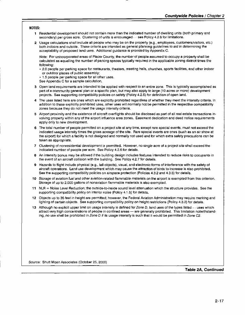
ilOTES:
1 Residential development should not contain more than the indicated numb€r of dwelling units (both primary andsecondary) per grgss acre. Clustering of units is encouraged -see Policy 4.2.6 for limitations,
2 Usage calculations shall include all people who may be onthe property (e.9., employees, customers/visitors, etc.)both indoors and outside. These criteria are intended as general planning guidelines to aid in determining theacceptability of proposed land uses. Additionalguidance is provided by Appendix C.
Note: Fot unincotpo.afed areas of Placer County, the number of people assumed to occupy a propert), shall becalculated as equalling the number of parking spaces typically required in the applicable zoning district times thefollowing:
' 2.0 people per parking space for restaurants, theaters, meeting halls, churches, sports facilities, and other indooror outdoor places ol public assemblyi
' 1.5 people per parking space for all other uses.See Appendix C for a sample calculation.
3 Open land requirements are intended to be applied with respect to an entire zone. This is typically accomplished aspart of a community general plan or a specific plan, but may also applyto large (10 acres or mo'e) developmentprojects. See supporting compatibility policies on safety (Policy4.2.5) for definition ofopen land.
4 The uses listed here are ones which are explicitly prohibited regardless of whether they meet the intensity criteria. In
addition to these explicitly prohibited uses, other uses will normally not be permitted in the respective compatibilityzones because they do not meet the usage intensity criteria.
5 Airport proximity and the existence of aircraft overflights should be disclosed as part ot all realestate transactions in-volving property within any ol the airport influence area zones. Easement dedication and deed notice requirementsapply only to new development.
6 The total number of people permitted on a project site at any time, except rare special events, must not exceed theindicated usage intensity times the gross acreage of the site. Rare special events are ones (such as an air show atthe airport) for which a facility is not designed and normally not us€d and for which extra satety precautions can betaken as appropriate.
7 Clustering of nonresidential development is permitted. However, no single acre ot a project sile shall exceed theindicated number of people per acre. See Policy 4.2.6 for details.
I An intensity bonus may be allowed if the building design includes features intended to reduce risks to occupants inthe event of an aircraft collision with the building. See Policy 4.2.7 for details.
I Hazards to flight include physical (e.9., tallobjects), visual, and electronic torms of interference with the saiety ofaircratt operations. Land use development which may cause the attraction of birds to increase is also prohibited.See the supporting compatibility policies on airspace protection (Policies 4,3.2 and 4.3.5) tor details.
10 Storage of aviation ruel and otber aviation-related llammable materials on the airport is exempted from this criterion.Storage of up to 2,000 gallons of nonaviation flammable materials is also exempted,
11 NLR = Noise Level Reduction; the outside-to-inside sound level attenuation rJyhich the structure provides. See thesupporting compatibility policy on interior noise (Policy 4.1.5) tor details.
'12 Objects upto35feetin heightare permitted; however, the FederalAviation Administration may require marking andlighting of certain objects. See supporting compatibility policy on height restrictions (Policy 4.3.2) for details.
13 Although no explicit upper limit on usage intensity is defined lot Zone D,land Ltses of the types listed - uses whichattract very high concentrations of people in confined areas - are generally prohibited. This Iimitation notwithstand-ing, no use shall be prohibited in Zore D it its usage intensity is such that it would be permitted in Zone C2.
Sourcer Shutt Moen Associates (October 25,2000)
Table 2A, Continued
2-17

Countwide Policies I Chapter 2
3. REVTEW oF ArRpoRT Mmftn PuNs nuo Drvrlopmrnr PuNs
3.1. Review Process
3.1.1. Project Submittal lnformation - An airport master plan or development plan sub-
mitted to the Commission for review shall contain sufficient information to enable
the Commission to adequately assess the noise, safety, airspace protection, and
overflight impacts of airport activity upon surrounding land uses. A master plan
report should be submitted, if available. At a minimum, information to be sub-
mitted shall include:
(a) A layout plan drawingof the proposed facility showing the location of: (1)
property boundaries; (2) runways or helicopter takeoff and landing areas; (3)
runway or helipad protection zones; and (4) aircraft or helicopter approach/
departure flight routes.
(b) Airspace surfaces in accordance with Federal Aviation Regulations, Paft77.
(c) Activity forecasts, including the number of operations by each type of aircraft
proposed to use the facility, the percentage of day versus night operations,
and the distribution of takeoffs and landings for each runway direction.
(d) Proposed flight track locations and projected noise contours or other relevant^^i-^ ;* ^-^+ .J^r^|,u,re "|'PoLr udrd.
(e) A map showing existing and planned land uses in the areas affected by air-
craft activity associated with implementation of the proposed master plan or
development plan.
(f) An environmental document, if one has been prepared and it addresses air-
port land use compatibility issues.
(g) ldentification and proposed mitigation of impacts on surrounding land uses.
3.1 .2. Commission Action Choices for Plans of Existing Arrports - When reviewing air-
port master plans or expansion plans for existing airports, the Commission has
three action choices:
(a) Find the airport plan consistent with lhe Airport Land Use Compatibility Plan.
(b) Find the airport plan inconsistent with the Commission's P/an.
(c) Modify the Airport Land Use Compatibility Plan (after duly noticed public
hearing) to reflect the assumptions and proposals in the airport plan.
2-18
3.1.3. Commission Action Choices for Reviews of New Airpons or Heliports - When re-
viewing proposals for new airports or heliports, the Commission's choices of ac-
tron are:
(a) Approve the proposal as being consistent with the specific review policies
listed in Section 3.3 below.
(b) Approve the proposal and adopt a Compatibility P/an for that facility. State
law requires adoption of such a plan if the airport or heliport will be a public-
use facility (State Aeronautics Act Section 21675(a)).
(c) Disapprove the proposal on the basis that the noise, safety, airspace protec-
tion, and overflight impacts it would have on surrounding land uses are not
adequately mitigated.
3.1.4. Response lime - The Airport Land Use Commission must respond to a local
agency's submittal of an airport master plan or development plan within 60 days
from the date of referral (State Aeronautics Act Section 21676(d)).
(a) lf the Commission fails to make a determination within that period, the pro-
posed action shall be deemed consistent with the Compatibility Plan.
(b) Regardless of Commission action or failure to act, the proposed action must
comply with other applicable local, state, and federal regulations and laws.
(c) The refening agency shall be notified of the Commission's actjon in writing
3.2. Review Criteria for Master or Development Plans of Existing Airports
3.2.1 . Substance of Review - When reviewing airport master plans or development
plans for existing airports, the Commission shall determine whether activity fore-
casts or proposed facility development identified in the plan differ from the fore-
casts and development assumed for that airport in this Airpoft Land Use Compati-
bility Plan. Attention should specifically focus on:
(a) Activity forecasts that are: (1 ) significantly higher than those in the Airport
Land Use Compatibility P/an; or which (2) include a higher proportion oflarger or noisier aircraft.
(b) Proposals to: (1) construct a new runway or helicopter takeoff and landing
area; (2) change the lengh, width, or landing threshold location of an existing
runway; or {3) establish an instrument approach procedure
2-19

3.2.2. Consistency Determination - The Commission shall determine whether the pro-
posed airport plan or development plan is consistent with lhe Airpoft Land Use
Compatibility P/an. The Commission shall base its determination of consistency
on findings that the forecasts and development identified in the airport plan
would not result in greater noise, overflight, and safety impacts or height restric-
tions on surrounding land uses than are assumed in the Airport Land Use Com-
patibility Plan-
3.3. Review Criteria for Proposed New Airports or Heliports
3.3.1 . Substance of Review - In reviewing proposals for new airports and heliports, the
Commission shall focus on the noise, safety, airspace protection, and overflight
impacts upon surrounding land uses.
(a) Other types of environmental impacts (e,g., air quality, water quality, natural
habitas, vehicle traffic, etc.) are not within the scope of Commission review.
(b) The Commission shall evaluate the adequacy of the proposed facility design
(in terms of federal and state standards) only to the extent that the design af-
fects surrounding land use.
(c) The Commission must base its review on the proposed airfield design. The
Commission does not have the authori& to require alterations to the airfield
desien.
3.3.2. AirporllLand Use Relationships - The review shall examine the relationships be-
tween existing and planned land uses in the vicinity of the proposed airport orheliport and the impacts that the proposed facility would have upon these land
uses. Questions to be considered should include:
(a) Would the existing or planned land uses be considered incompatible with the
airport or heliport if the latter were already in existence?
(b) What measures are included in the airport or heliport proposal to mitigate
the noise, safety, airspace protection, and overflight impacts on surrounding
land uses? Such measures might include: (1)location of flight tracks so as tominimize the impacts; (2) other operational procedures to minimize impacts;(3) installation of noise barriers or structural noise insulation; (4) acquisition ofproperty interests (fee title or easements) on the impacted land.
2-20

Counwde Policies I Chapter 2
4. SUPPoRTING COMPATIBILITY CNITTNII
4.1 . Noise
4.1 .1. Prolected Noise leve/s - The evaluation of airport/land use noise compatibility
shall consider the future Community Noise Equivalent Level (CNEL) contours of
each airport as depicted in Chapters 4, 5, and 6 of this plan. These contours are
calculated based upon aircraft activity forecasts which are set forth in an airport
master plan or which are considered by the Placer County Airpoft Land Use
Commission to be plausible (refer to activity data in Chapters 4, 5, and 6). The
Airport Land Use Commission or the entities which operate airports in Placer
County should periodically review the projected noise level contours and update
them if appropriate.
4.1 .2. Application of Norse Contours - The locations of CNEL contours are among the
factors used to define compatibilitv zone boundaries and criteria. lt is intended
that noise compatibility criteria be applied at the general plan, specific plan, or
other broad-scale level. Because of the inherent variability of flight paths and
other factors that influence noise emissions, the depicted contour boundaries are
not absolute determinants of the compatibility or incompatibility of a given land
use. Noise contours can only quantify noise impacts in a general manner; except
on large parcels or blocks of land (sites large enough to have 3 dB or more of vari-
ation in CNELs), they should not be used as site design criteria. (Note, though,
that the airport noise contours set forth in this P/an are to be used as the basis for
determining compliance with interior noise level criteria as listed in Policy 4.1 .5.)
4.1.3. Noise Fxposure in Residential Areas - The maximum CNEL considered normally
acceptable for residential uses in the vicinity of the airpofts covered by this P/an is
60 dB.
4.1 .4. Norse fxposure for Other Land Uses - Noise level compatibility standards for
other types of land uses shall be applied in the same manner as the above resi-
dential noise level criteria. The extent of outdoor activity associated with a par-
ticular land use is an important factor to be considered in evaiuating its compati-
bility with airpoft noise. Examples of acceptable noise levels for other land uses
in an airport's vicinity are presented in Table 28.
4.1 .5. /nterlor Norse leve/s - Land uses for which interior activities may be easily dis-
rupted by noise shall be required to comply with the following interior noise level
criteria.
(a) The maximum, aircraft-related, interior noise level which shall be considered
acceptable for land uses near airportJ is 45 dB CNEL in:
' Living and sleeping areas of single- or multi-family residences;
> Hotels and motels;
' Hospitals and nursing homes;
' Churches, meeting halls, office buildings, and mortuaries; and
' Schools, libraries, and museums.
(b) The noise contours depicted in Chapters 4, 5, and 6 of this P/an shall be used
in calculating compliance with these criteria. Also, the calculations should
assume that windows are closed.
(c) When reviewed as part of a general plan or zoning ordinance amendment or
as a major land use action, evidence that proposed structures will be de-
signed to comply with these criteria shall be submitted to the ALUC under
the following circumstances:
(1) Any mobile home situated within an airport's 55-dB CNEL contour. [A
typical mobile home has an exterior-to-interior noise level reduction(NLR) of approximately 15 dB with windows closed.l
(2) Any single- or multi-family residence situated within an airport's 60-dB
CNEL contour. IWood frame buildings constructed to meet 1990s stan-
dards for energy efficiency typically have an NLR of approximately 20
dB with windows closed.l
(3) Any hotel or motel, hospital or nursing home, church, meeting hall, of-
fice building, mortuary, school, library, or museum situated with an air-
oort's 65-dB CNEL contour.
4.1 .6. Engine Run-Up and Testing Noise - ALUC consideration of noise from these ac-
tivities shall be limited as follows:
(a) Aircraft noise associated with preJlight engine run-ups, taxiing of aircraft toand from runways, and other operation of aircraft on the ground is consid-
ered part of airport operations and therefore is not subject to ALUC authority.
(1) However, the Commission may take into account noise from these
sources when reviewing the compatibility of proposed land uses near
the airport to ihe extent that this noise is reflected in airport noise con-
tours approved by the airport proprietor and the Commission.
(2) Noise from aircraft ground operations also should be considered by the
Commission when reviewing airport master plans or development plans
in accordance with Section 3 herein.
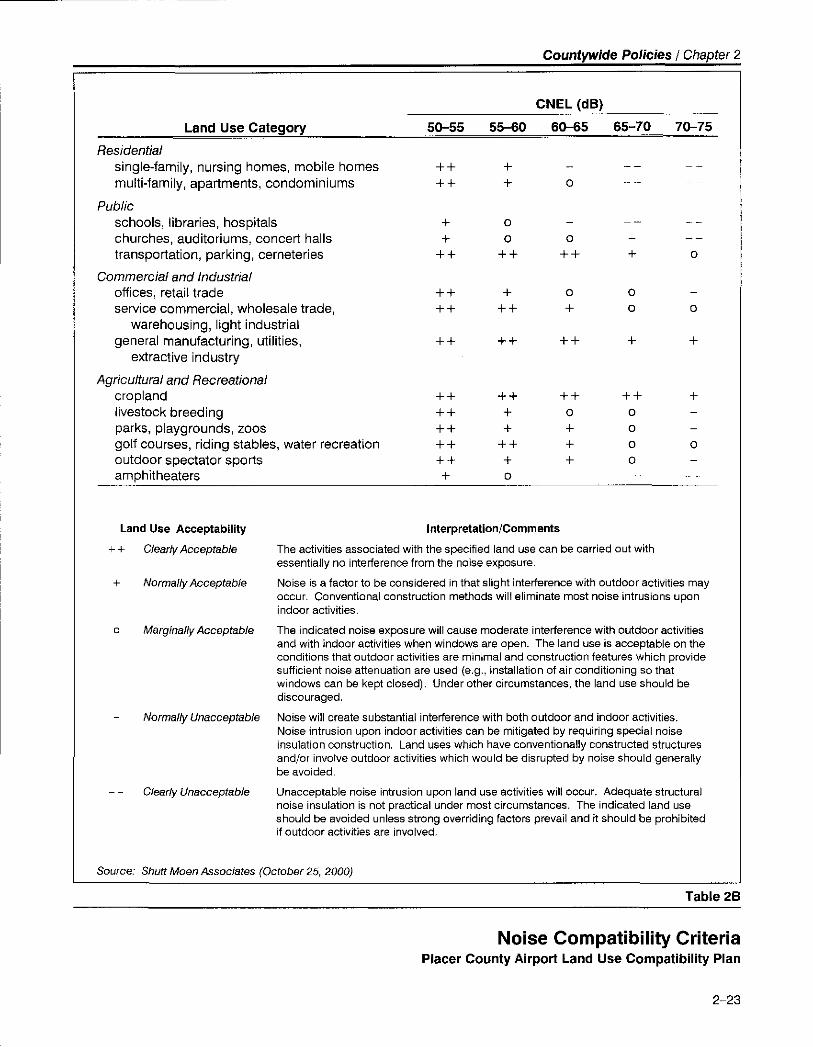
Countwide Poticies I Chapter 2
Residentialsinglejamily, nursing homes, mobile homesmultiJamily, apartments, condominiums
Publicschools, libraries, hospitalschurches, auditoriums, concert hallstransportation, parking, cemeteries
Commercial and lndustrialolfices, retail tradeservice commercial, wholesale trade,
warehousing, light industrialgeneral manufacturing, utilities,
e)itractive industry
Agricultural and Recrcationalcroplandlivestock breedingparks, playgrounds, zoosgolf courses, riding stables, water recreationoutdoor spectator sportsamphitheaters
++
++
++
+++
++
o
+
++
+
+
++
o
+
oooo
o
o
+
+
+
o
Land Use Category
CNEL (dB)
5G55 55-60 6(H5 65-70 7V75
Land Use Acceptability
++ Clearly Acceptable
+ No(mally Acceptable
Marginally Acceptable
Normally Unacceptable
Clearly Unacceptable
Source: Shuft Moen Associates (October 25, 2000)
Interprelation/Comments
The activities associated with the specified land use can be carried out withessentially no interlerence from the noise exposure.
Noise is a factor to be considered in that slight interterence with outdoor activities mayoccur. Conventional construction methods \,/vill elimanate most noise intrusions uponindoor activities.
The indicated noise exposure wall cause moderate interference with outdoor activitiesand with indoor activities when windows are oDen. The land use is acceDtable on theconditions that outdoor activities are minimal and construction features which providesufficient noise attenuation are used (e.9., installation of air conditioning so thatwindows can be kept closed). Under other circumstances, the land use should bediscouraged.
Noise will create substantial interference with both outdoor and indoor activities.Noise intrusion upon indoor activities can be mitigated by requiring special noiseinsulation construction. Land uses which have conventionally constructed structuresand/or involve outdoor activities which would be disrupted by noise should generallybe avoided.
Unacceptable noise intrusion upon land use activities willoccur. Adequate structuralnoise insulation is not practical under most circumstances. The indicated land useshould be avoided unless strong overriding factors prevail and it should be prohibitedil outdoor activities are involved.
Table 28
Noise Compatibillty GriteriaPlacer County Airport Land Use Compatibility Plan
2-23

(b) Noise from the testing of aircraft engines on airport property is not deemed
an activity inherent in the operation of an airport and thus it is not an airport-
related impact addressed by this Compatibility Plan. Noise from these
sources should be addressed by the noise policies of local agencies in the
same manner as noise from other industrial sources. (Engine testing noise is
not normally included in the noise contours prepared for an airport. How-
ever, aircraft noise modeling programs have the capability of including noise
from this source. At airports where engine testing takes place or is proposed,
the ALUC may need to ascertain whether the noise was or was not included
in the noise contour calculations.)
4.1 .7 . Construction of New or Expanded Airports or Heliports - Any proposed con-
struction of a new airport or heliport or expansion of facilities at an existing air-
port or heliport which would result in a significant increase in cumulative noise
exDosure (measured in terms of CNEL) shall include measures to reduce the ex-
posure to a lessthan-signi{icant level. For the purposes of this plan, a noise in-
crease shall be considered sienificant if:
(a) ln locations having an existing ambient noise level of less than 60 dB CNEL,
the project would increase the noise level by 5.0 dB or more.
(b) In locations having an existing ambient noise level of between 60 and 65 dB
CNEL, the project would increase the noise level by 3.0 dB or more.
(c) In locations having an existing ambient noise level of more than 65 dB CNEL,
the pro.ject would increase the noise level by 1,5 dB or more.
4.2. Safety
4.2.1. Objective - The intent of land use safety compatibility criteria is to minimize the
risks associated with an off-airport aircraft accident or emergency landing.
(a) Risks both to people and property in the vicinity of an airpod and to people
on board the aircraft shall be considered.
(b) More stringent land use controls shall be applied to the areas with greater
noLential risk.
4.2.2. Risks to People on the Cround -fhe principal means of reducing risks to people
on the ground is to restrict land uses so as to limit the number of people lvho
might gather in areas most susceptible to aircraft accidents. (Methods for detet-
mining the concentration of people for various land uses are provided in Appen-
dix C.)

Counwide Policies I Chapter 2
4.2.3. Land l-.Jses of Particular Concern - Land uses of particular concern are ones in
which the occupants have reduced effective mobility or are unable to respond to
emergency situations. Children's schools and day care centers (with 7 or more
children), hospitals, nursing homes, and other uses in which the maiority of occu-
pants are children, elderly, and/or handicapped shall be prohibited within all
Compatibility Zones except Zone D.
(a) This general policy may be superseded by airport specific policies (see Chap-
ter 3).
(b) Hospitals are medical facilities which include provision for overnight stays by
patients. Medical clinics are permitted in Compatibility Zones C1 and C2
provided that these facilities meet the maximum intensity standards found in
Table 2A, Primary Compatibility Criteria.
4.2.4. Other Rrlks - Storage of fuel and other hazardous materials within the airport
environs is restricted as follows:
(a) Within Compatibility Zone A, storage of any such substance is prohibited.
(b) Within Compatibility Zones B7 and 82, only the following is permitted:
(1) Fuel or hazardous substances stored in underground tanks.
(2) On-airport storage of aviation fuel and other aviation-related flammable
materials.
(3) Up to 2,000 gallon of nonaviation flammable materials.
4.2.5. Open Land - In the event that a light aircraft is forced to land away from an air-
port, the risks to the people on board can best be minimized by providing as
much open land area as possible within the airport vicinity. This concept is
based upon the fact that the majority of light aircraft accidents and incidents oc-
curring away from an airport runway are controlled emergency landings in which
the pilot has reasonable opportunity to select the landing site.
(a) To qualify as open land, an area should be:
(1) Free of most structures and other major obstacles such as walls, large
trees or poles (greater than 4 inches in diameter, measured 4 feet above
the ground), and overhead wires.
(2) Have minimum dimensions of approximately 25 feet by 300 feet.
(b) Roads and automobile parking lots are acceptable as open land areas if they
meet the above criteria.
(c) Open land requirements for each compatibility zone are to be applied withrespect to the entire zone. Individual parcels may be too small to accommo-
date the minimum-size open area requirement. Consequently, the identifica-
2-25
tion of open land areas must initially be accomplished at the general plan or
specific plan level or as part of large-acreage projecs.
Clustering of development and providing contiSuous landscaped and parking
areas is encouraged as a means of increasing the size of open land areas.
Building envelopes and the airport compatibility zones should be indicated
on all development plans and tentative maps for proiects located within the
influence area of airports covered by rhis Compatibility P/an in order to assure
that individual development projects provide the open land areas identified
in the applicable general plan, specific plan, or other large-scale plan.
4.2.6. Limitations on Clustering - Policy a.2.5.(d) notwithstand ing, limitations shall be
set on the maximum degree of clustering or usage intensity acceptable within a
portion of a large project site.
(a) Clustering of new residential development shall be limited as follows:
(1\ Zone A: Not applicable.
(2) Zones 81 and 82: Maximum of 4 dwelling units per any individual
acre. Buildings shall be located as far as practical from the extended
runway centerline and shall be limited to a maximum of two stories in
height.
ZoneCl: No limit except that buildings shall beamaximumof three
stories in height.
Zones C2 and Dr No limit.
(b) Unless special design measures as listed in Policy 4.2.7 are utilized, usage in-
tensity of new nonresidential development shall be limited as follows:
(d)
(e)
(3)
(4)
(1)
12)
Zone A: No clustering permitted.
Zone 81: Maximum of 50 people per any individual acre (i.e., a maxi-
mum of double the average intensity criterion set in Table 2A). Office
buildings with three or more floors, retail stores with two or more floors,
fasrfood establishments, large shopping centers (500,000 or more
square feet), theaters, motels, and similar uses typically do not comply
with this criterion.
Zone 82: Maximum of 100 people per any individual acre (i.e., a maxi-
mum of double the average intensity criterion set in Table 2A). Office
buildings with three or more floors, retail stores with two or more floors,
large shopping centers (500,000 or more square feet), theaters, motels,
and similar uses typically do not comply with this criterion.
Zone C1: Maximum of 1 50 people per any ind ividual acre (i.e., a maxi-
mum of double the average intensity criterion set in Table 2A). Large
shopping centers (500,000 or more square feet), theaters, motels and
(3)
z-zo
\4)

Counwide Policies I Chapter 2
hotels with three or more floors, and similar uses typically do not com-
olv with this criterion.
(5) Zone C2: Maximum of 300 people per any individual acre (i.e., a maxi-
mum of triple the average intensity criterion set in Table 2A),
6\ Zone D: No limit.
For the purposes of the above policies, the one-acre areas to be evaluated
shall be squares (209 feet by 209 feet).
In no case shall a proposed development be designed to accommodate more
than the total number of dwelling units per acre (for residential uses) or peo-
ple per acre (for nonresidential uses) indicated in Table 2A times the gross
acreage of the proiect site. A project site may include multiple parcels.
Cross acreage equals the property acreage plus a share of adjacent roads.
Appendix D lists examples of the types of land uses which are potentially
compatible under these criteria and the types of land uses which are consid-
ered incomoatible.
4.2.7 . Risk Reduction Through Building Design * ln Zones 81 , 82, C1 , and C2, lhenumber of people permitted to occupy a single nonresidential building may be
increased by a factor of up to 1.3 times the limitations set by the preceding policy
on clustering if special measures are taken to reduce the risks to building occu-
pants in the event that the building is struck by an aircraft.
(a) Building design features which would enable application of an intensity bo-
nus include, but are not limited to, the following:
' Using concrete walls;> Limiting the number and size of windows;
' Upgrading the strength ofthe building roof;
' Avoiding skylights;
' Enhancing the fire sprinkler system;
' Limiting buildings to a single story; and
' lncreasing the number of emergency exits.
Project proponents who wish to request an intensity bonus must include ap-
propriate details of the building design along with their project review appli-
cation.
Intensity bonuses shall be considered and approved by affected local lurisdic-tions on a case-by-case basis. The criteria to be used by each jurisdiction
when considering intensity bonus requests shall be reviewed and approved
by the ALUC as part of the general plan consistency process.
|.c)
(d)
(b)
(c.)

4.3. Airspace Protection
4.3.1 . Basis for Height limits - The criteria for limiting the height of structu res, trees,
and other obiects in the vicinity of an airport shall be based upon: Part 77,Sub'part C, ofthe Federal Aviation Regulations (FAR); the United States Standard for
Terminal Instrument Procedures (TERPS); and applicable airport design standards
published by the Federal Aviation Administration. Airspace plans depicting the
critical areas for airspace protection around each of the airports covered by this
Compatibility Plan are depicted in Chapters 4, 5, and 6.
4.3.2. Height Restrictions - The height of objects within the influence area of each air-
port shall be reviewed, and restricted if necessary, according to the following cri-
teria. The locations of these zones are depicted on the respective Compatibility
Map for each airport.
(a) Within Compatibility Zone A:
(1) The height of all objects shall be limited in accordance with applicable
Federal Aviation Administration criteria including FAR Part 77,TERPS,
and/or airport design standards.
(b) Within Compatibility Zones 81, 82, or Height Review Overlay Zone:
(1) Objects up to 35 feet tall are acceptable and do not require ALUC re-
view for the purposes of height factors.
(2) ALUC review is required for any proposed object taller than 35 feet.
(3) Federal Aviation Administration review may be necessary for proposed
objects adjacent to the runway edges and the FAA may require marking
and lighting of certain ob.iects (the affected areas are generally on airport
ProPertY)
(c) Within Compatibility Zone C1 :
(1 ) Cenerally, there is no concern with regard to any object up to 70 feet
tall unless it is located on high ground or it is a solitary object (e.9., an
antenna) more than 35 feet taller than other nearby obiects.(d) Within Compatibility Zone C2 or Compatibility Zone D:
(1) Cenerally, there is no concern with regard to any ob.ject up to 150 feet
tall unless it is located on high ground or it is a solitary obiect (e.9., an
antenna) more than 35 feet above the qround.
4.3.3. Avigation Easement Dedication - As a condition for development approval, the
owner of any property proposed for development within Compatibility Zones A,
81, or 82 or a Height Review Overlay Zone shall be required to dedicate an
2-28

avigation easement to the entity owning the affected airport. The avigation ease-
ment shall:
(a) Provide the right of flight in the airspace above the property;
(b) Allow the generation of noise and other impacts associated with aircraft over-
flight;
(c) Restrict the height of structures, trees and other objects;
(d) Permit access to the property for the removal or aeronautical marking of ob-
jects exceeding the established height limit; and
(e) Prohibit electrical interference, glare, and other potential hazards to flight
from being created on the propefty. An example of an aviSation easement is
provided in Appendix F.
4.3.4. FAA Notification - Proponents of a pro.ject which may exceed aPartTT surtace
must notify the Federal Aviation Administration as required by FAR Part 77, Sub-
part B, and by the State Aeronautics Act, Sections 21658 and 21659. (Notifica-
tion to the Federal Aviation Administration under FAR Part 77, Subpart B, is re-
quired even for certain proposed construction that does not exceed the height
limits allowed by Subpart C of the regulations. Referto Appendix Bforthespe-cific Federal Aviation Administration notification requirements.)
(a) Local jurisdictions shall inform proiect proponents of the requirements for
notification to the Federal Aviation Administration.
(b) The requirement for notification to the Federal Aviation Administration shall
not necessarily trigger an airport compatibility review of an individual project
by the Airport Land Use Commission if the project is otherwise in confor-
mance with the comoatibilitv criteria established herein.
(c) FM review is required for any proposed structure more than 200 feet above
the surface level of is site. All such proposals also shall be submitted to the
ALUC for review regardless of where in the county they would be located.
(d) Any pro.ject submitted to the ALUC for airport land use compatibility review
for reason of height-limit issues shall include a copy of FAR Part77 notilica-
tion to the Federal Aviation Administration.
4.3.5. Other Flight Hazards - New land uses wh ich may cause visual, electronic, or in-
creased bird strike hazards to aircraft in flight shall not be permitted within any
airport's in{luence area. Specific characteristics to be avoided include:
(a) Clare or distracting lights which could be mistaken for airport lights;
(b) Sources of dust, steam, or smoke which may impair pilot visibility;
2-29

(c) Sources of electrical interference with aircraft communications or navigation;
and
Any proposed use, especially landfills and cedain agricultural uses, which cre-
ates an increased attraction for large flocks of birds. (Refer to FAA Order
5200.5A, Waste Disposal Sites on or Near Airports and Advisory Circular 150/
5200-33, Hazardous Wildlife Attractants On or Near Airports.)
4.4. Overflights
4.4.1- Nature of Concern - Overflight compatibility concerns encompass a combina-
tion of noise and safety issues. Although sensitivity to aircraft overflights varies
from one person to another, overflight sensitivity is particularly important with
regard to residential land uses.
(a) For the purposes of the Compatibility Plan, the frequency of overflights, the
typical overflight altitude, the noise levels of individual aircraft operations, the
characteristics of the noise (helicopter noise being particularly intrusive), and
the perceived necessity of the noise (noise from fire attack aircraft being con-
sidered more acceptable than noise from other loud aircraft) are the principal
determinants of where overflighs are considered to be a potential concern,
(b) The area of overflight concerns is the same as the airport influence area for
each airport.
4.4.2. Buyer Awareness Measures (Airpoft lmpact Disclosure) - Because all of each alr-
port's influence area is subject to aircraft overflights, it is important that prospec-
tive purchasers of property within this area, particularly residential properties, are
informed about the property's proximity to a nearby airport.
la) ln Compatibility Zones C1 and C2, a deed notice shall be recorded for each
parcel associated with any discretionary land use action reviewed by the Air-
port Land Use Commission. (Note that the avigation easement required by
Policy 4.3.3 to be dedicated in conjunction with developmentin Zones A,
81, 82, and the Herght Review Overlay Zone serves as a deed notice in those
locations.)
(b) Each land use jurisdiction affected by this Compatibillty Plan should adopt a
policy designating the airport influence area as an area which may be regu-
larly subject to aircraft overflight. The policy should note that owners and
residents of property within this area may find such overflights to be annoying
and/or disruptive to their enjoyment of the propefty. Property owners should
be put on notice that the proximity of the airport and the potential for routine
aircraft overflights should be disclosed in conjunction with any real estate
transaction involving properties within the airport influence area.
(d)
2-30

4.4.3. Land Llse Conversion - The compatibility of uses in the airport influence areas
shall be preserved to the maximum feasible extent. Particular emphasis should
be placed on preservation of existing agricultural and open space uses.
(a) The conversion of land from existing or planned agricultural, industrial, or
commerciaf use to residential uses within CompatibilitY Zones A, 81 , 82, and
C7 Js strongly discouraged.
(b) ln Compatibility Zone C2, general plan amendments (as well as other discre-
tionary actions such as rezoning subdivision approvals, use permits, etc.)
which would convert land to residential use or increase the density of resi-
dential uses should be subject to careful consideration of overflight impacts.
2-31

qtrtr
lndividual Airport Policiesand Compatibility Maps
1. BAsIs rOn COMpRTIBILITY ZONr BOUNDARIES
1 .1 . General
The general concepts used to develop the compatibility zone boundaries for the three public-
use airpofts in Placer County are outlined below. These basic, aviation-oriented, boundartes
were then modified to take into account distinct geographic features and existing land uses
around each airport. The compatibility zone boundaries represent a composite of noise, safety,
ai rspace protection, and overfl i ght concerns.
1.1 .1. Compatibility Zone A-ZoneA includes airport runways and immediately adia-
cent areas wherein uses are restricted to aeronautical functions in accordance with
Federal Aviation Administration standards. The lateral limiu of Zone A are gener-
ally defined by the airfield building restriction lines as depicted on the Airport Lay-
out Plan for each airport. The length ol Zone A is set to encompass the runway
protection zone located at each end ofthe runway. Runway protection zone di-mensions are defined by Federai Aviation Administration airport design standards
and take into account the runway approach type and the type of aircraft the run-
way is intended to accommodate. In addition to being an area of high risk, Tone A
also is subject to high noise levels. The Community Noise Equivalent Level ex-
ceeds 65-dB within much of Zone A at each airport (except Blue Canyon).
1.1 .2. Compatibility Zone 81 -Zone
B1 encompasses the portions of the runway ap-
proach/departu re areas adjacent to and beyond the ends of the runway protection
zones (Zone A). The length of the zone is primarily determined by the type of ap-
proach procedure existing or planned at each runway end. Noise levels and risks
are both high in these areas. Cumulative noise levels are generally at least 55 dB
CNEL (except at Blue Canyon). Also, noise produced by individual aircraft opera-
3-1

tions are often high enough to disrupt many land use activities. Risk levels are high
because ofthe proximity ol Zone B'l to the runway ends and because these areas
are overflown by aircraft at low altitudes - typically only 200 to 400 feet above
the runway elevation. Additionally, restrictions on the heiSht of objects (generally
not less than 50 feet) may be required for airspace protection purposes.
1 .1 .3. Compatibility Zone 82 - Zone 82 at each airport extends laterally from and along
the length ofthe nearest runway. Sideline aircraft noise is the key factor in this
area, both cumulative and single-event. Run-up noise may also be a concern in
some locations. The zone width is generally set so as to encompass the 60-dB
CNEL contour. Risk is also a factor, but less so than in Zone 81 . HeiSht restrictions
may be required as well.
1-1.4. Compatibility Zone C1 - Zone C7 covers the extended approach/departu re corri-
dor for each airport and also includes land beneath the primary traffic patterns.
This zone is affeaed by moderate degrees of both noise and risk. Cumulative
noise levels exceed 55 dB CNEL in portions ol Zone C'l and noise from individual
aircraft operations is disruptive to noise-sensitive land uses. Aircraft overfly this
area at or below the traffic pattern altitude of '1,000 feet above the runway eleva-
tion. According to the data presented in the Caltrans Handbook,4O% to 50% ofoff-runway, airport-related, general aviation aircraft accidenG occur within Zones Iand C7 for airports comparable to each of the Placer County airports. Portions ofZone C'l lie beneath the Federal Aviation Regulations Paft 77 transitional surface
airspace - restrictions may be required on tall ob.iects (ones greater than 100 feet
high).
'l .1 .5. Compatibility Zone C2 - Zone C2 encompasses areas routinely overflown by air-
craft approaching and departing the airports, but less frequently or at higher alti-
tudes than the areas within Zone C1. The zone includes locations along the pat-
tern entry routes, within instrument approach corridors, and beneath wide pat-
terns flown by large aircraft. Aircraft typically overfly these areas at an altitude of'1,000to 1,500 feet above ground level onvisual approaches. Annoyance associ-
ated with aircraft overflights is the major concern within Zone C2. Although the
zone lies outside the 55-dB CNEL contour, noise from individual aircraft overflights
may adversely affect ceftain land uses. Safety is a concern only with regard to uses
involving high concentrations of people and to particularly risk-sensitive uses such
as schools and hospitals.
1.1.6. Compatibility Zone D - Areas within Zone D are sometimes overflown by aircraft
arriving and departing the airport. Hazards to flight are the only compatibility con-
cern. The outer limits of the zone coincide with the outer edge of the conical sur-
face defined by Federal Aviation Regulations Part 77 for each airport. Except on
high terrain, height limits are no less than .150 feet within this area.
3-2

1 .2. Special Conditions
At some airports, special conditions as provided for in Policy 2.4.3.(e) of Chapter 2 have
been acknowledged by the Airport Land Use Commission in adoption of this Compatibil-
ity Plan. These special conditions result in establishment of compatibility zone boundaries
and/or compatibility criteria different in character from the zones and criteria applicable
to other airports in the county. Where any such additional policies have been adopted
for a particular airport, they are listed in the following sections of this chapter. These spe-
cial policies are not to be generalized or considered as precedent applicable to other loca-
tions near the same airport or to the environs of other airports addressed by this plan.
3-3
2. AUBURN Mulrctplt AtnPoRr
2.1. Compatibility Map Delineation
2.1.1. Compatibility Map - The Compatibility Map for Auburn Municipal Airport is pre-
sented in Figure 3A and is to be used in conjunction with the criteria set forth in
Table 2A.
2.1.2. Boundary Determinants
(a) The Zone A boundaries are defined by the building restriction line and runway
protection zone boundaries as indicated on the airport layout plan for the ex-
tended runway. The zone is all on airport property.
(tt) Zone 81 encompasses most of the future 6O-dB CNEL contour. Also included
are locations typically overflown by aircraft at less than 300 feet above ground
level on visual approaches to either end of the runway. At the west end of the
runway, the zone bends southward to reflect the 20" left turn which aircraft
are encouraged to make when taking off from Runway 25. Thelengthatthewest end takes into account the fact that ground elevations are well below the
runway elevation.
Zone 82 contains the areas along each side of the runway where noise is more
of a factor than risk. The zone width is set to encompass most of the 60-dB
CNEL contour.
Zone Cl includes the 55-dB CNEL contour plus locations beneath the pre-
dominantly used (south-side) traffic pattern. The edges of these areas fall close
to well-defined roads and property lines, thus for convenience the zone
boundaries are shown on these geographic features.
Zone C2 contains the north-side traffic pattern plus additional areas along the
south-side traffic pattern and within the common arrival and departure corri-
dor to the west.
Zone D includes remaining areas lying within the outer boundaries of the FAR
Part ,/ ,/ contcal sunace.
(cl
(d)
(el
(fl
34

2.2. Additional Compatibility Policies
2.2.1 Sutter Auburn Faith Hospita/ - The criteria set forth in Table 2A of Chapter 2 nohvith-
standing, hospitals and nursing homes shall not be prohibited within that poftion of Com-
patibility Zones C1 and C2 which includes the existing hospital property and adjacent
parcels designated with a # symbol on the Auburn Municipal Airport Compatibility Map(Figure 3A).(a) Any new structures to be used as a hospital or nursing home shall be limited to no
more than two aboveground habitable floors and, to the extent feasible, shall in-
corporate other design features which would help protect the building occupants
in the event of an aircraft crash (for example, minimizing extensive glass areas in
exterior wa s).
(b) This special policy shall apply only to the area indicated and not to any other loca-
tions within the Auburn Municipal Airport environs or the environs of others air-
ports addressed by this plan.
3-5

3. BruE CeruvoN AlnPonr
3.1 . Compatibility Map Delineation
3.1.1. Compatibility Map - The Compatibility Map for Blue Canyon Municipal Airport is
presented in Figure 3B and is to be used in conjunction with the criteria set forth
in Table 2A.
3.1 .2. Boundary Determinants
(a) Zone A extends 1,200 feet beyond each runway end to encompass the runway
protection zones as well as laterally to the building restriction line (200 feet
from the runway centerline).
(bJ Zone B7 is shorter than at other ajrports in the county in recognition of the low
aircraft activity volume at Blue Canyon Airport. Included are locations where
aircraft may be less 200 feet above the runway elevation when on approach tolandings.
lc) Zone 82 provides a buffer zone laterally from the runway in recognition of the
fact that a small degree of risk is present in this area,
(d) Zone C7 includes additional locations beneath the approach surface defined
by FAR Part 77. The airport has insufficient activity to warrant extending the
zone to include the airport traffic pattern.
(e) No Zone C2 is established for this airport because of the low activity level.
(f) fhe Zone D limits match the airport's FAR Part 77 conical surface boundary
and encompasses the airport traffic pattern.
3.2. Additional Compatibility Policies
None.
5-,o

[This page intentionally blank]
3-7

4. LrNcotN RrcloNll AtnPonr
4.1. Compatibility Map Delineation
4.1 .1. Compatibility Map -fhe Compatibility Map for Lincoln Regional Airport is pre-
sented in Figure 3C and is to be used in conjunction with the criteria set forth in
Table 2A and the additional policies listed in Section 4.2 ofthis chapter.
4.1.2. Boundary Determinants
(a) Zone A encompasses the area adjacent to and at the ends of the existing run-
way and proposed parallel runway, The width is based upon the building re-
striction line shown on the current Lincoln Regional Airport Layout Plan. The
length contains the runway protection zone of each runway.
(b) The limits o[ Zone 81 reflect both noise and safety concerns consistent with
the types of instrument approach procedures established at the airport, the
types of aircraft which operate there, and the projected volume of aircraft ac-
tivity. Lack of significant existing or anticipated future compatibility conflicts
within the zone also is a factor in the zone size. The length of the zone is pri-
marily set with respect to the point at which aircraft pass below 300 feet above
the ground when approaching the runway on a straisht-in instrument ap-
proach. This distance also encompasses the 55-dB CNEL contour.
Zone 82 consists of two areas adiacent to Zone A, one on each side of the run-
ways. The length of the zone is based on the length of the existing runway.
The lengh on the east side is predicated on the city's adoption of a pclicy
which will require aircra{t approaching and departing the future runway toavoid turns closer than the ends of the primary runway. The width of the zone
takes into account the future runwav and is set so as to contain the future 60-
dB CNEL contour.
Zone C1 contains the east and west traffic patterns for the existing runway, as
well asthe pattern forthe potential future parallel runway. Extensions ofthezone are established to the north and south because aircraft on nonprecision
instrument approaches may overfly these areas at altitudes under 600 feet
above the ground. Noise from individual aircraft operations is a factor in these
locations,
Z.one C2 encompasses the typical traffic patterns entry corridors and widerpatterns usually flown by large aircraft.
(c)
(d)
3-8
(e.)
(fl Zone D contains the remainder of the airport's FAR Part 77 conical surface
4.2. Additional Compatibility Policies
4.2.1. fhe new municipal wastewater treatment facility which the city of Lincoln pro-
poses to build south of Moore Road within the outer end of CompatibilitY Zone Cl(some 2.3 miles south of the airport) is deemed to be consistent with the Chapter
2 policy (Policy 4.3.5) regarding avoidance of land uses which increase the attrac-
tion of birds. This finding is based upon two factors: (1) the city's intent to design
the facility so as to minim jze its of attraction birds to the extent feasible; and (2)
the new facility will replace the existing wastewater treatment plant located only a
mile southeast of the airport.
3-9