Embed Size (px)
Citation preview

Chapter 7
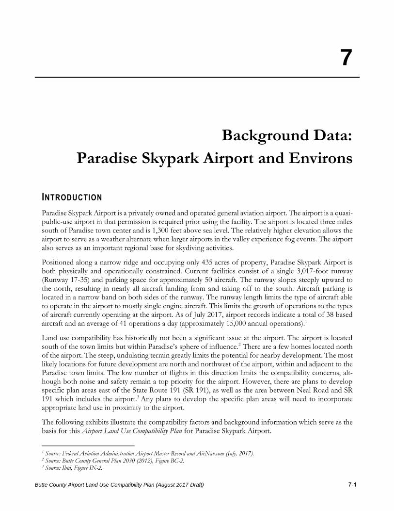
7
Butte County Airport Land Use Compatibility Plan (August 2017 Draft) 7-1
Background Data:
Paradise Skypark Airport and Environs
INTRODUCTION
Paradise Skypark Airport is a privately owned and operated general aviation airport. The airport is a quasi-public-use airport in that permission is required prior using the facility. The airport is located three miles south of Paradise town center and is 1,300 feet above sea level. The relatively higher elevation allows the airport to serve as a weather alternate when larger airports in the valley experience fog events. The airport also serves as an important regional base for skydiving activities.
Positioned along a narrow ridge and occupying only 435 acres of property, Paradise Skypark Airport is both physically and operationally constrained. Current facilities consist of a single 3,017-foot runway (Runway 17-35) and parking space for approximately 50 aircraft. The runway slopes steeply upward to the north, resulting in nearly all aircraft landing from and taking off to the south. Aircraft parking is located in a narrow band on both sides of the runway. The runway length limits the type of aircraft able to operate in the airport to mostly single engine aircraft. This limits the growth of operations to the types of aircraft currently operating at the airport. As of July 2017, airport records indicate a total of 38 based aircraft and an average of 41 operations a day (approximately 15,000 annual operations).1
Land use compatibility has historically not been a significant issue at the airport. The airport is located south of the town limits but within Paradise’s sphere of influence.2 There are a few homes located north of the airport. The steep, undulating terrain greatly limits the potential for nearby development. The most likely locations for future development are north and northwest of the airport, within and adjacent to the Paradise town limits. The low number of flights in this direction limits the compatibility concerns, alt-hough both noise and safety remain a top priority for the airport. However, there are plans to develop specific plan areas east of the State Route 191 (SR 191), as well as the area between Neal Road and SR 191 which includes the airport.3 Any plans to develop the specific plan areas will need to incorporate appropriate land use in proximity to the airport.
The following exhibits illustrate the compatibility factors and background information which serve as the basis for this Airport Land Use Compatibility Plan for Paradise Skypark Airport.
1 Source: Federal Aviation Administration Airport Master Record and AirNav.com (July, 2017). 2 Source: Butte County General Plan 2030 (2012), Figure BC-2. 3 Source: Ibid, Figure IN-2.
CHAPTER 7 BACKGROUND DATA: PARADISE SKYPARK AIRPORT AND ENVIRONS
7-2 Butte County Airport Land Use Compatibility Plan (August 2017 Draft)
Exhibit 7-1: Airport Features Summary. Presents information pertaining to the airport configura-tion, operational characteristics and applicable planning documents.
Exhibit 7-2: Simplified Airport Diagram. The Airport Diagram (April 2013) depicts the existing airfield configuration and airport building areas.
Exhibit 7-3: Airport Activity Data Summary. This table summarizes existing future aircraft activ-ity. Currently, the airport sees approximately 15,000 annual operations. The forecast for future aircraft operations are assumed to be approximately twice the estimated existing activity levels (i.e., 30,000 annual operations).
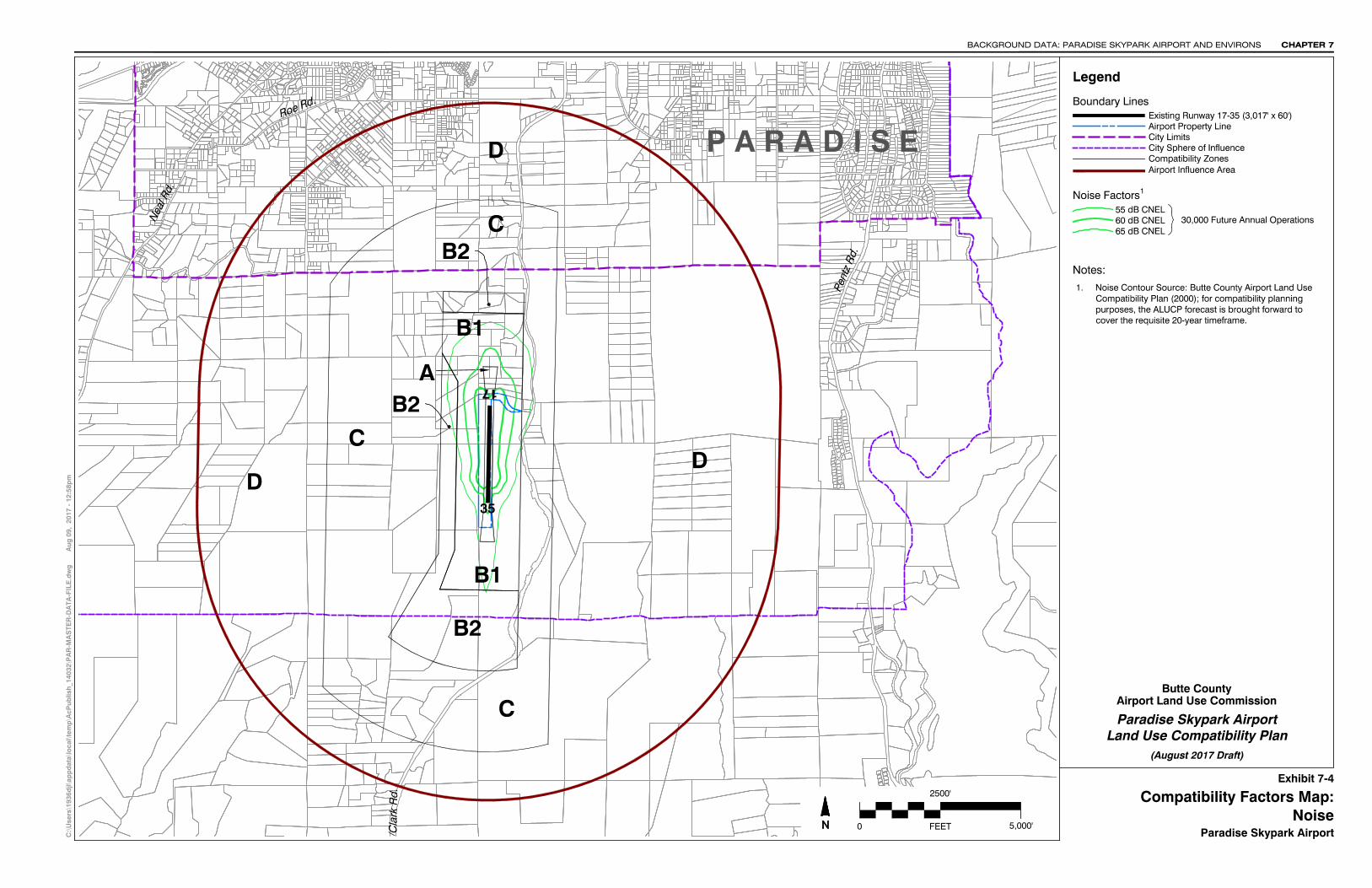
Exhibit 7-4 through 7-7: Compatibility Factors. Depicts the extents of the four compatibility fac-tors upon which the Compatibility Zones for Paradise Skypark Airport were derived. The four compat-ibility factors are defined by:
▫ Noise – Future noise contours reflecting an ultimate aircraft activity forecast level of 30,000 annual operations.
▫ Safety – Generic safety zones provided in the California Airport Land use Planning Handbook (October 2011) are applied to the existing runway configuration in the following manner:
· Runway 17-35: Generic safety zones for a short general aviation runway (length less than 4,000 feet) are applied to the existing runway configuration.
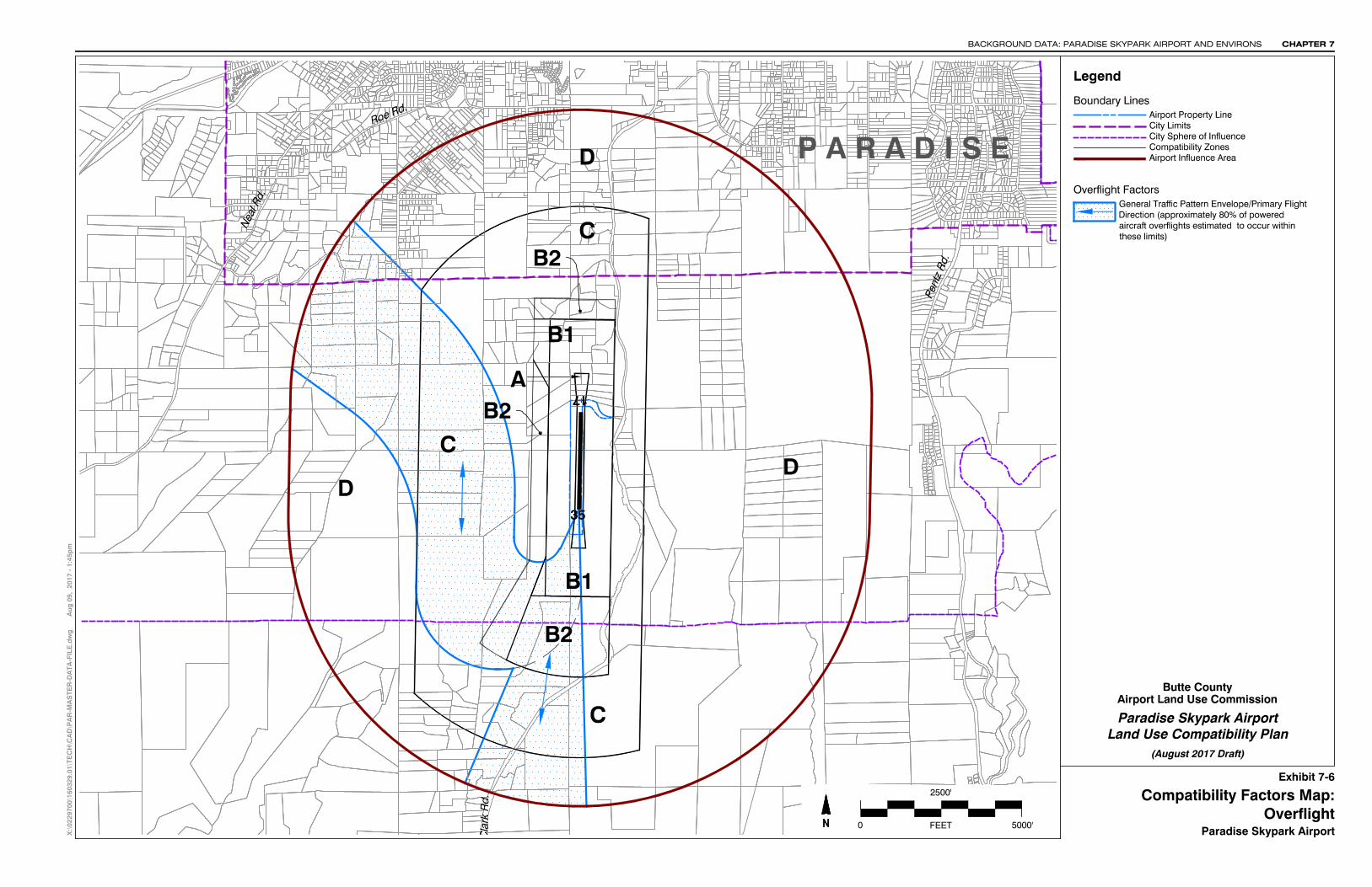
▫ Overflight – Primary traffic patterns reflecting where aircraft operating at the airport routinely fly.
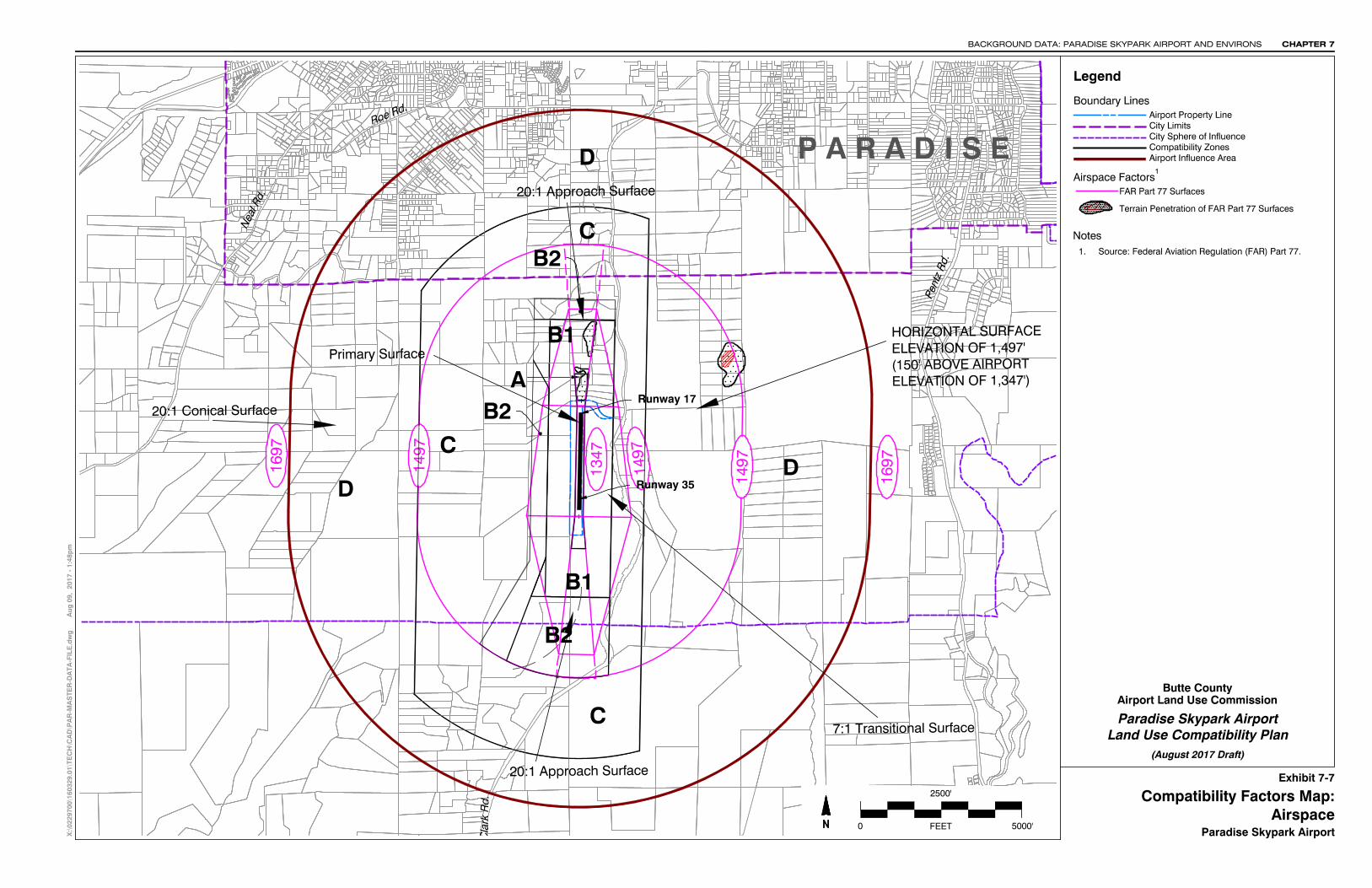
▫ Airspace Protection – Outer boundary of the Obstruction Surfaces as defined by Federal Aviation Regulation (FAR) Part 77, Safe, Efficient Use and Preservation of the Navigable Airspace.
Exhibit 7-8: Airport Environs Information. Summarizes information about current and planned land uses in the environs of the Chico Municipal Airport. The status of local general plans and airport land use compatibility policies contained in those plans are also summarized.
Exhibit 7-9: County of Butte General Plan Land Uses. Shows the planned land use designations as reflected in the Butte County General Plan 2030 Land Use Element (amended November 2012).
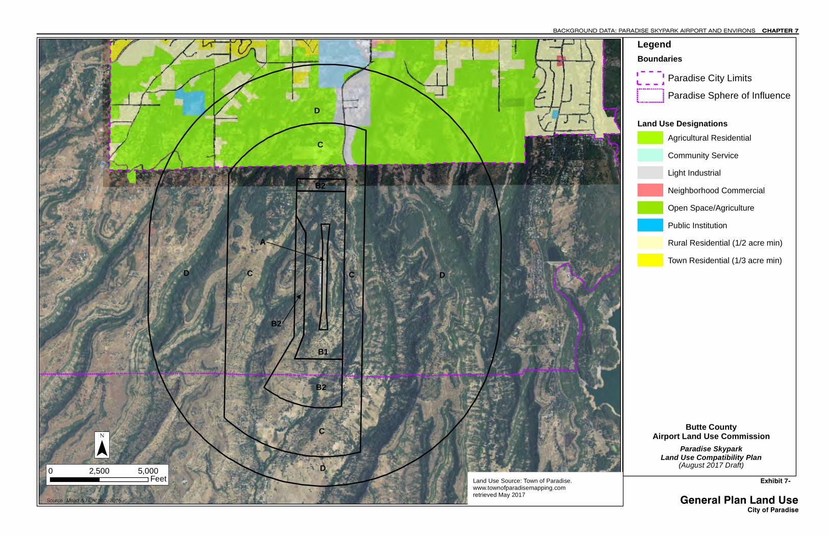
Exhibit 7-10: Town of Paradise General Plan Land Uses. Shows planned land use designations as summarized in the adopted Town of Paradise General Plan Land Use Diagram (amended January 2008).

BACKGROUND DATA: PARADISE SKYPARK AIRPORT AND ENVIRONS CHAPTER 7
Butte County Airport Land Use Compatibility Plan (August 2017 Draft) 7–3
Exhibit 7-1
Airport Features Summary Paradise Skypark Airport
GENERAL INFORMATION
Airport Ownership/Use ▫ Private; permission required prior to landing
Property Size: ▫ Fee Title: 35 acres ▫ Avigation easements: Data unavailable
Airport Classification: General Aviation, community use
Airport Elevation: 1,300 feet MSL Access:
▫ Via Airport Road to northeast corner of airport ▫ State Route 191 0.2 miles east
AIRPORT PLANNING DOCUMENTS
Airport Master Plan ▫ None
Airport Layout Plan Drawing (April 2013)
RUNWAY/TAXIWAY DESIGN
Runway 17-35
Critical Aircraft: Light, single-engine piston Airport Category/Design Group
▫ Airport Reference Code A-I (Small) Dimensions: 3,017 ft. long, 60 ft. wide; paved overrun
beyond each end; Runway 17 threshold displaced 427 ft. Pavement Strength
▫ 4,000 lbs (single wheel main gear) Average Gradient: 2.0% (rising to north) Runway Lighting: Low-intensity edge lights Primary Taxiways: Full-length parallel on northeast
▫ Parallel taxiway along south_ of runway length on east ▫ Partial parallel midfield on west ▫ Both parallel taxiways substandard distance from
runway
APPROACH PROTECTION
Runway Protection Zones (RPZs) ▫ Runway 17: 1,000-ft. long; 30% on airport property ▫ Runway 35: 1,000-ft. long; 20% on airport property
Approach Obstacles ▫ 115 ft. tree, 1200 ft. from runway, 25 ft. left of
centerline, 25:1 slope to clear ▫ 17/35 Hangars 125 ft. west of runway centerline, 150
ft. east of runway centerline
BUILDING AREA
Location: Midfield, east and west sides of runway Aircraft Parking Capacity
▫ Hangar spaces for 22± aircraft ▫ Tiedown spaces for 30± aircraft (based & transient)
Services ▫ Aviation gasoline (attendant service, daytime,
weekdays) ▫ Flight instruction; aircraft rental; pilot supplies ▫ Major aircraft overhaul ▫ Scenic flights; skydiving school
TRAFFIC PATTERNS AND APPROACH PROCEDURES
Airplane Traffic Patterns ▫ Runway 35: Left traffic ▫ Runway 17: closed to landing traffic ▫ Pattern Altitude: 1,000 feet AGL ▫ Airport approved for day and night operations
Instrument Approach Procedures (lowest minimums) ▫ None
Visual Approach Aids ▫ Airport: None ▫ Runway 17: None ▫ Runway 35: Tri-color VASI
Operational Restrictions ▫ Runway slopes steeply upward to north ▫ Runway 17 used only for takeoffs due to mountainous
terrain and trees approx. 450-700 yards from runway end
▫ Runway 35 used for landings, only ▫ Steep downgrade east; west; & south of runway
▫ Parachute drop zone north of runway
PLANNED FACILITY IMPROVEMENTS
Building Area ▫ Future hangar construction as need ▫ Ultimate aircraft parking capacity: 40± hangar spaces;
40± tiedowns
Notes Sources: Data Compiled by Mead and Hunt (July 2017); FAA 5010, AIRNAV, 2006 Airport Permit.
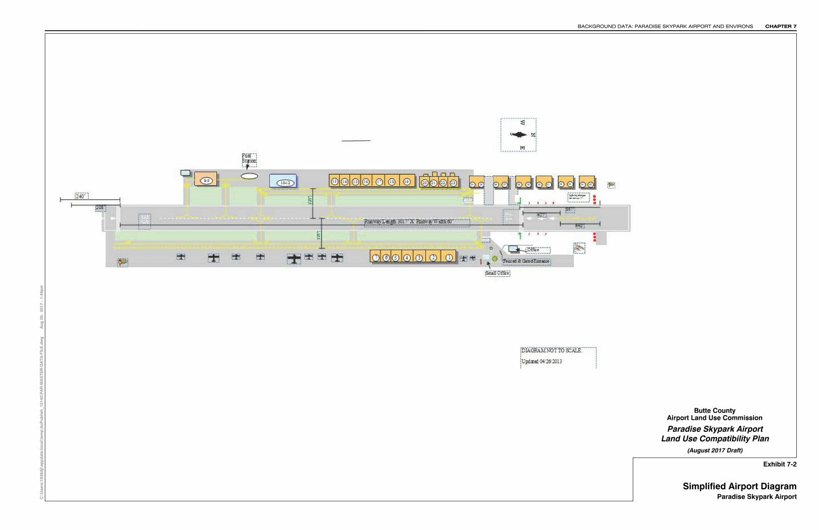
Exhibit 7-2
Paradise Skypark Airport
Butte County
(August 2017 Draft)Land Use Compatibility Plan
C:\
Use
rs\1
936d
jl\ap
pd
ata\
loca
l\tem
p\A
cPub
lish
_151
40\P
AR
-MA
STE
R-D
ATA
-FIL
E.d
wg
Aug
09,
201
7 -
1:49
pm
Simplified Airport DiagramParadise Skypark Airport
Airport Land Use Commission
CHAPTER 7BACKGROUND DATA: PARADISE SKYPARK AIRPORT AND ENVIRONS
CHAPTER 7 BACKGROUND DATA: PARADISE SKYPARK AIRPORT AND ENVIRONS
7–4 Butte County Airport Land Use Compatibility Plan (August 2017 Draft)
Exhibit 7-3
Airport Activity Data Summary Paradise Skypark Airport
BASED AIRCRAFT Current a Future b
2016 2030 Aircraft Type Single-Engine 36 95 Multi-Engine 2 5
Turboprop 0 0 Turbojet 0 0
Helicopters 1 0 Total Based Aircraft 38 100
AIRCRAFT OPERATIONS Current a Future b 2016 2030 Total
Annual 15,000 30,000
Average Day, Annual 41 82 Distribution by Aircraft Type b Single-Engine 97% Multi-Engine 3% no Turboprop <1% change Turbojet 0% Military <1% Distribution by Type of Operation b
Local (incl.touch-and-goes) c 67% no Itinerant 33% change
RUNWAY USE DISTRIBUTION Current b Future Takeoffs Takeoffs Runway 17 100% no Runway 35 <1% change Landings, Day Runway 17 2% no Runway 35 98% change Landings, Night Runway 17 0% no Runway 35 100% change
TIME OF DAY DISTRIBUTION b Day Evening Night All Aircraft Current 95% 4% 1% Future no change
FLIGHT TRACK USAGE b
All Aircraft Aircraft departing runway 17 normally make 15°
right turn to follow valley
Notes a Source: Federal Aviation Administration (FAA) Airport Master Record and AirNav.com (July 2017). b Source: Butte County Airport Land Use Compatibility Plan (2000). For compatibility planning purposes, the forecast is brought forward to cover the requisite 20-year timeframe; future aircraft operations are approximately twice the estimated existing activity levels. c Infrequent touch-and-goes because of runway slope and threshold displacement. Source: Data Compiled by Mead & Hunt (July 2017)
P A R A D I S E
Sta
te H
wy.
191/
Cla
rk R
d.
Roe Rd.
Nea
l Rd.
Pent
z Rd
.
B2
DC
D
B1
B1
B2
C
D
A
C
B2
Paradise Skypark AirportNoise
Exhibit 7-4
CHAPTER 7BACKGROUND DATA: PARADISE SKYPARK AIRPORT AND ENVIRONS
C:\
Use
rs\1
936d
jl\ap
pd
ata\
loca
l\tem
p\A
cPub
lish
_140
32\P
AR
-MA
STE
R-D
ATA
-FIL
E.d
wg
Aug
09,
201
7 -
12:5
8pm
City LimitsAirport Property Line
Boundary Lines
Noise Factors
60 dB CNEL65 dB CNEL
30,000 Future Annual Operations
Legend
55 dB CNEL
Compatibility Factors Map:
Compatibility ZonesAirport Influence Area
City Sphere of Influence
Paradise Skypark Airport
Butte County
(August 2017 Draft)Land Use Compatibility Plan
Airport Land Use Commission
Existing Runway 17-35 (3,017' x 60')
0 FEET
2500'
5,000'
Notes:1. Noise Contour Source: Butte County Airport Land Use
Compatibility Plan (2000); for compatibility planningpurposes, the ALUCP forecast is brought forward tocover the requisite 20-year timeframe.
1
3517

P A R A D I S E
6 6
4
3 312
66
4
3 31
5 5
2
Sta
te H
wy.
191/
Cla
rk R
d.
Roe Rd.
Nea
l Rd.
Pent
z Rd
.
B2
DC
D
B1
B1
B2
C
D
A
C
B2
Paradise Skypark AirportSafety
Exhibit 7-5
CHAPTER 7BACKGROUND DATA: PARADISE SKYPARK AIRPORT AND ENVIRONS
C:\
Use
rs\1
936d
jl\ap
pd
ata\
loca
l\tem
p\A
cPub
lish
_140
32\P
AR
-MA
STE
R-D
ATA
-FIL
E.d
wg
Aug
09,
201
7 -
12:5
9pm
City LimitsAirport Property Line
Boundary Lines
Legend
Compatibility Factors Map:
Compatibility ZonesAirport Influence Area
City Sphere of Influence
Runway Factors1
Paradise Skypark Airport
Butte County
(August 2017 Draft)Land Use Compatibility Plan
Airport Land Use Commission
Runway Protection Zone
Existing Runway 17-35 (3,017' x 60')
Safety Factors2
Short General Aviation Runway (up to 3,999') Applied to Runway 17-35
Runway Protection ZoneInner Approach/Departure ZoneInner Turning ZoneOuter Approach/Departure ZoneSideline ZoneTraffic Pattern Zone
Zone 1Zone 2Zone 3Zone 4Zone 5Zone 6
0 FEET
2500'
5,000'
3517
Notes:1. Runway Protection Zone Source: Butte County Airport
Land Use Compatibility Plan (2000); for compatibilityplanning purposes, the RPZs for a A-I (small) runwayare brought forward for this ALUCP.
2. Source: California Airport Land Use Planning Handbook(2011).
P A R A D I S E
Sta
te H
wy.
191/
Cla
rk R
d.
Roe Rd.
Nea
l Rd.
Pent
z Rd
.
B2
DC
D
B1
B1
B2
C
D
A
C
B2
Exhibit 7-6
Paradise Skypark Airport
Butte County
(August 2017 Draft)Land Use Compatibility Plan
LegendX
:\02
2970
0\16
0329
.01\
TEC
H\C
AD
\PA
R-M
AS
TER
-DA
TA-F
ILE
.dw
g
A
ug 0
9, 2
017
- 1:
45p
m
OverflightCompatibility Factors Map:
Paradise Skypark Airport
Overflight Factors
Airport Land Use Commission
City LimitsAirport Property Line
Boundary Lines
Compatibility ZonesAirport Influence Area
City Sphere of Influence
General Traffic Pattern Envelope/Primary FlightDirection (approximately 80% of poweredaircraft overflights estimated to occur withinthese limits)
0 FEET 5000'
2500'
CHAPTER 7BACKGROUND DATA: PARADISE SKYPARK AIRPORT AND ENVIRONS
35
17
P A R A D I S E
Sta
te H
wy.
191/
Cla
rk R
d.
Roe Rd.
Nea
l Rd.
Pent
z Rd
.
1497
16971497
1347
1497
1697
B2
DC
D
B1
B1
B2
C
D
A
C
B2
20:1 Approach Surface
20:1 Conical Surface
7:1 Transitional Surface
Primary SurfaceHORIZONTAL SURFACEELEVATION OF 1,497'(150' ABOVE AIRPORTELEVATION OF 1,347')
20:1 Approach Surface
Exhibit 7-7
Paradise Skypark Airport
Butte County
(August 2017 Draft)Land Use Compatibility Plan
FAR Part 77 Surfaces
Legend
Terrain Penetration of FAR Part 77 Surfaces
X:\
0229
700\
1603
29.0
1\TE
CH
\CA
D\P
AR
-MA
STE
R-D
ATA
-FIL
E.d
wg
Aug
09,
201
7 -
1:48
pm
AirspaceCompatibility Factors Map:
Paradise Skypark Airport
Airport Land Use Commission
City LimitsAirport Property Line
Boundary Lines
Compatibility ZonesAirport Influence Area
City Sphere of Influence
Airspace Factors
0 FEET 5000'
2500'
CHAPTER 7BACKGROUND DATA: PARADISE SKYPARK AIRPORT AND ENVIRONS
Runway 17
Runway 35
1. Source: Federal Aviation Regulation (FAR) Part 77.Notes
1

BACKGROUND DATA: PARADISE SKYPARK AIRPORT AND ENVIRONS CHAPTER 7
Butte County Airport Land Use Compatibility Plan (August 2017 Draft) 7-5
Exhibit 7-8
Airport Environs Information Paradise Skypark Airport
AIRPORT LOCATION
Location ▫ Central Butte County ▫ 3 miles south of central Paradise
Topography ▫ Airport situated at 1,344 feet elevation on ridge above
eastern edge of Sacramento Valley ▫ Slightly higher terrain along ridge to north; lower eleva-
tions elsewhere ▫ Higher mountains 5± miles north and east
AIRPORT ENVIRONS LAND USE JURISDICTIONS
County of Butte ▫ Airport and immediate environs in unincorporated
Butte County jurisdiction Town of Paradise
▫ City limits under 1 mile north of airport ▫ Airport within city sphere of influence
EXISTING AIRPORT AREA LAND USES
General Character ▫ Scrub on steeply sloping ridges and valleys ▫ Sparsely populated except toward north
Runway Approaches ▫ North (Runway 17): widely scattered dwellings along
ridge ▫ South (Runway 35): steep slope; grazing land below
Traffic Pattern ▫ Steep terrain; sparsely populated grazing land
STATUS OF COMMUNITY PLANS
Butte County General Plan 2030 ▫ Adopted October 2010, amended November 2012
Town of Paradise General Plan ▫ Adopted 1994, amended 1998 ▫ Town of Paradise Housing Element, adopted Decem-
ber 2009 ▫ Proposed Southeast Paradise Specific Plan ▫ Proposed Paradise Urban Reserve Specific Plan
PLANNED AIRPORT AREA LAND USES
County of Butte ▫ Foothill residential zoning, Mixed use, resource con-
servation, agricultural and heavy industrial surrounding the airport
▫ Minimum parcel sizes vary from 5 acres northeast of airport to 20 acres northwest and 40 acres on south and east
Town of Paradise ▫ Nearest areas in city limits planned for agricultural res-
idential uses (minimum 1-acre parcels) with industrial service development along Hwy 191
▫ Proposed expansion to the 3,571-acre area between Neal Road and State Route 191 south of Paradise, in-cluding the Paradise Urban reserve area and the air-port; mix of uses to be determined by the Paradise Ur-ban Reserve Specific Plan¹
▫ Proposed Southeast Paradise Specific Plan will cover 1,206 acres of incorporated and unincorporated mu-nicipalities of Butte County west of State Route 191 and south of paradise. Anticipated 800 new residential and 5 acres of retail uses²
Notes: 1 Source: Butte County General Plan 2030, Figure IN-2 2 Source: Ibid.
CHAPTER 7 BACKGROUND DATA: PARADISE SKYPARK AIRPORT AND ENVIRONS
7-6 Butte County Airport Land Use Compatibility Plan (August 2017 Draft)
Exhibit 7-8, continued
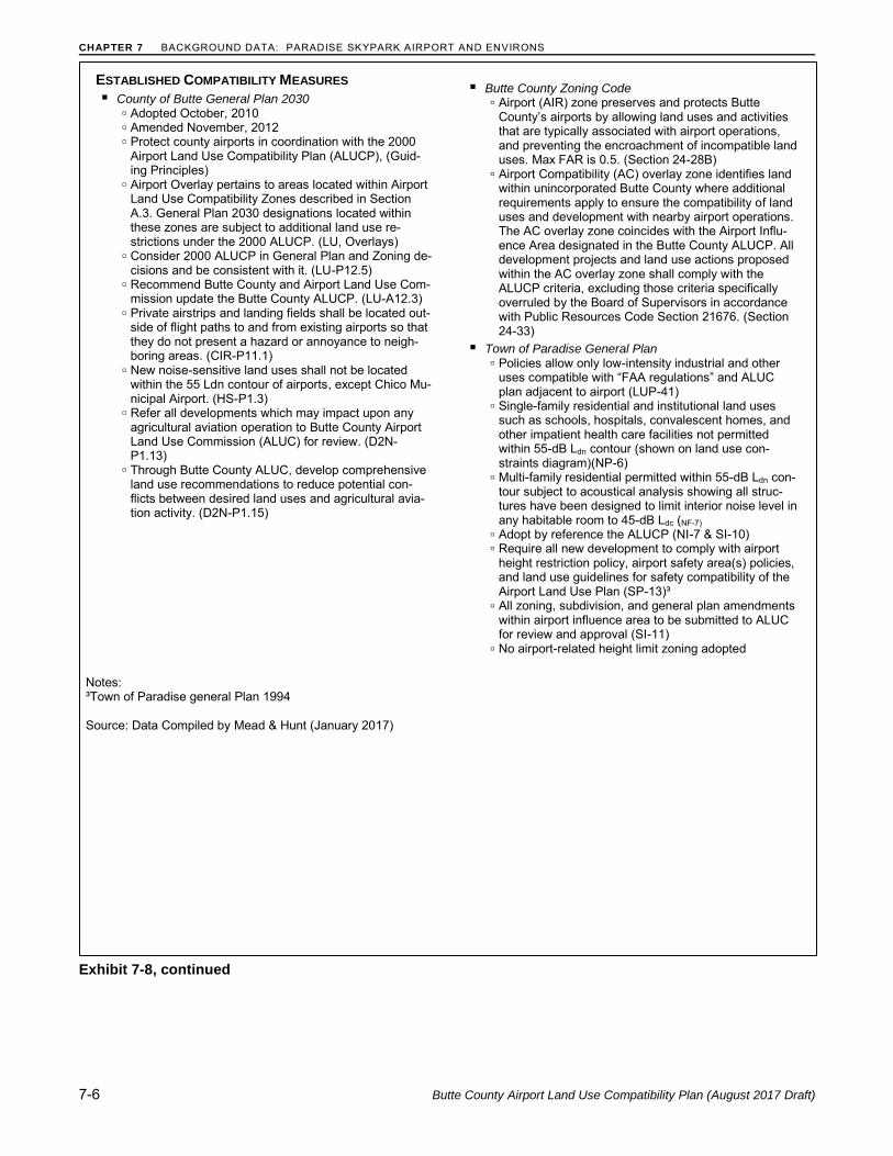
ESTABLISHED COMPATIBILITY MEASURES
County of Butte General Plan 2030 ▫ Adopted October, 2010 ▫ Amended November, 2012 ▫ Protect county airports in coordination with the 2000
Airport Land Use Compatibility Plan (ALUCP), (Guid-ing Principles)
▫ Airport Overlay pertains to areas located within Airport Land Use Compatibility Zones described in Section A.3. General Plan 2030 designations located within these zones are subject to additional land use re-strictions under the 2000 ALUCP. (LU, Overlays)
▫ Consider 2000 ALUCP in General Plan and Zoning de-cisions and be consistent with it. (LU-P12.5)
▫ Recommend Butte County and Airport Land Use Com-mission update the Butte County ALUCP. (LU-A12.3)
▫ Private airstrips and landing fields shall be located out-side of flight paths to and from existing airports so that they do not present a hazard or annoyance to neigh-boring areas. (CIR-P11.1)
▫ New noise-sensitive land uses shall not be located within the 55 Ldn contour of airports, except Chico Mu-nicipal Airport. (HS-P1.3)
▫ Refer all developments which may impact upon any agricultural aviation operation to Butte County Airport Land Use Commission (ALUC) for review. (D2N-P1.13)
▫ Through Butte County ALUC, develop comprehensive land use recommendations to reduce potential con-flicts between desired land uses and agricultural avia-tion activity. (D2N-P1.15)
Butte County Zoning Code
▫ Airport (AIR) zone preserves and protects Butte County’s airports by allowing land uses and activities that are typically associated with airport operations, and preventing the encroachment of incompatible land uses. Max FAR is 0.5. (Section 24-28B)
▫ Airport Compatibility (AC) overlay zone identifies land within unincorporated Butte County where additional requirements apply to ensure the compatibility of land uses and development with nearby airport operations. The AC overlay zone coincides with the Airport Influ-ence Area designated in the Butte County ALUCP. All development projects and land use actions proposed within the AC overlay zone shall comply with the ALUCP criteria, excluding those criteria specifically overruled by the Board of Supervisors in accordance with Public Resources Code Section 21676. (Section 24-33)
Town of Paradise General Plan ▫ Policies allow only low-intensity industrial and other
uses compatible with “FAA regulations” and ALUC plan adjacent to airport (LUP-41)
▫ Single-family residential and institutional land uses such as schools, hospitals, convalescent homes, and other impatient health care facilities not permitted within 55-dB Ldn contour (shown on land use con-straints diagram)(NP-6)
▫ Multi-family residential permitted within 55-dB Ldn con-tour subject to acoustical analysis showing all struc-tures have been designed to limit interior noise level in any habitable room to 45-dB Ldc (NF-7)
▫ Adopt by reference the ALUCP (NI-7 & SI-10) ▫ Require all new development to comply with airport
height restriction policy, airport safety area(s) policies, and land use guidelines for safety compatibility of the Airport Land Use Plan (SP-13)³
▫ All zoning, subdivision, and general plan amendments within airport influence area to be submitted to ALUC for review and approval (SI-11)
▫ No airport-related height limit zoning adopted
Notes: ³Town of Paradise general Plan 1994 Source: Data Compiled by Mead & Hunt (January 2017)
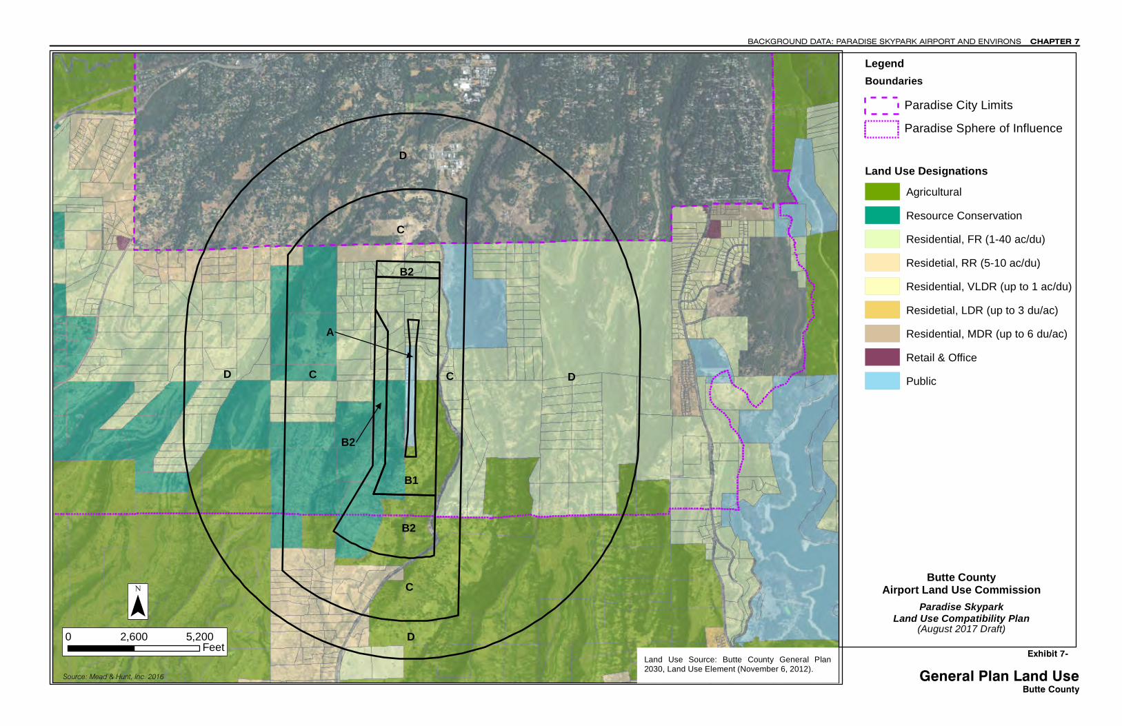
A
B1
B2
B2
C
DD
C
D
D
C C
B2
Source: Mead & Hunt, Inc. 2016
0 2,600 5,200Feet
¯Land Use Source: Butte County General Plan2030, Land Use Element (November 6, 2012).
(August 2017 Draft)
Exhibit 7- General Plan Land Use
Butte County
CHAPTER 7BACKGROUND DATA: PARADISE SKYPARK AIRPORT AND ENVIRONS
Paradise SkyparkLand Use Compatibility Plan
Butte CountyAirport Land Use Commission
Land Use DesignationsAgricultural Resource ConservationResidential, FR (1-40 ac/du)Residetial, RR (5-10 ac/du)Residential, VLDR (up to 1 ac/du)Residetial, LDR (up to 3 du/ac)Residential, MDR (up to 6 du/ac)Retail & OfficePublic
BoundariesParadise City LimitsParadise Sphere of Influence
Legend
A
B1
B2
B2
C
DD
C
D
D
C C
B2
Source: Mead & Hunt, Inc. 2016
0 2,500 5,000Feet
¯
Legend
Land Use Designations
(August 2017 Draft)Exhibit 7-
General Plan Land UseCity of Paradise
CHAPTER 7BACKGROUND DATA: PARADISE SKYPARK AIRPORT AND ENVIRONS
Paradise SkyparkLand Use Compatibility Plan
Butte CountyAirport Land Use Commission
Agricultural ResidentialCommunity ServiceLight IndustrialNeighborhood CommercialOpen Space/AgriculturePublic InstitutionRural Residential (1/2 acre min)Town Residential (1/3 acre min)
Land Use Source: Town of Paradise.www.townofparadisemapping.comretrieved May 2017
Boundaries
Paradise City LimitsParadise Sphere of Influence

Chapter 8
8
Butte County Airport Land Use Compatibility Plan (August 2017 Draft) 8-1
Background Data:
Ranchaero Airport and Environs
INTRODUCTION
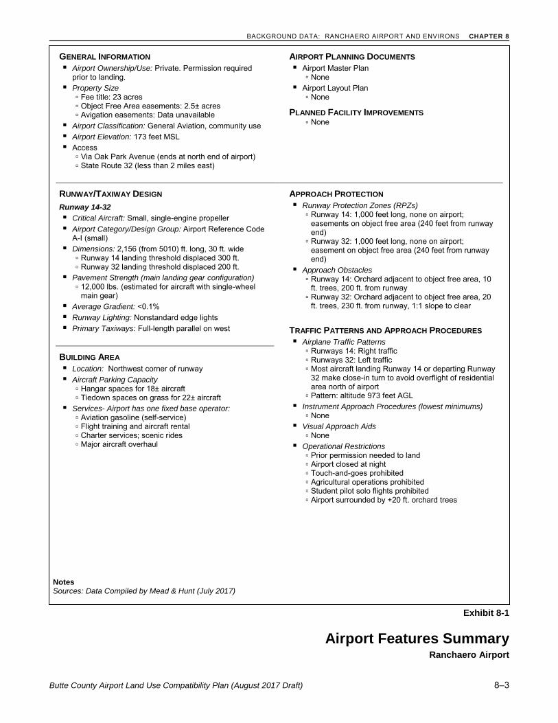
Ranchaero Airport is a privately owned and operated 23-acre general aviation facility situated near the southwestern edge of the City of Chico. The airport is a quasi-public use facility in that permission is required prior to using the airport. The airport serves a combination of recreational, flight training, agri-cultural, and limited business functions. The airport’s single 2,156-foot runway (Runway 14-32) currently handles 5,000 aircraft operations per year with 34 based aircraft. 1 The short runway limits use to single-engine airplanes and helicopters.
Overall, the basic configuration of this privately owned air-strip has remained unchanged since its con-struction in 1946. Historically, land use compatibility conflicts involving the airport have stemmed from two sources. The major issue arose because of the airport’s lack of control over the runway protection zones. As a result, orchards were planted which became obstructions to the runway approaches. This issue was addressed with the airport’s acquisition of easements over the inner parts of the runway pro-tection zones. The second conflict is presented by the subdivision north of the airport. To avoid over-flight of the homes, most aircraft landing at the airport turn for final approach less than 1,000 feet from the runway end. Aircraft taking off toward the north also usually make a close-in turn. These procedures, together with the airport’s low volume of activity, have minimized the problem.
Currently there are no predictions of significant new compatibility issues. No major changes in the char-acter of either the airport of the surrounding land uses are anticipated. The City of Chico’s urban devel-opment area boundary and the Butte County “green line” both preclude extensions of urban uses into the agricultural lands west of the city.
The following exhibits illustrate the compatibility factors and background information which serve as the basis for this Airport Land Use Compatibility Plan for Ranchaero Airport.
Exhibit 8-1: Airport Features Summary. Presents information pertaining to the airport configura-tion, operational characteristics and applicable planning documents.
1 Source: Federal Aviation Administration Airport Master Record and AirNav.com (July 2017).
CHAPTER 8 BACKGROUND DATA: RANCHAERO AIRPORT AND ENVIRONS
8-2 Butte County Airport Land Use Compatibility Plan (August 2017 Draft)
Exhibit 8-2: Simplified Airport Diagram. The Airport Diagram (2017) depicts the existing airfield configuration and airport building areas.
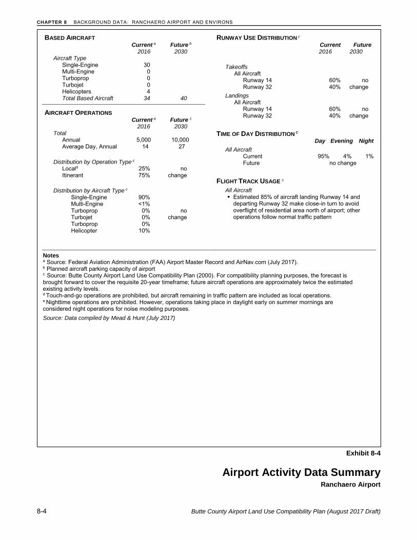
Exhibit 8-3: Airport Activity Data Summary. The table summarizes existing and future aircraft activity data. Currently, the airport sees approximately 5,000 annual operations. Future aircraft oper-ations are assumed to be approximately twice the estimated existing activity levels for compatibility planning purposes (i.e., 10,000 annual operations).
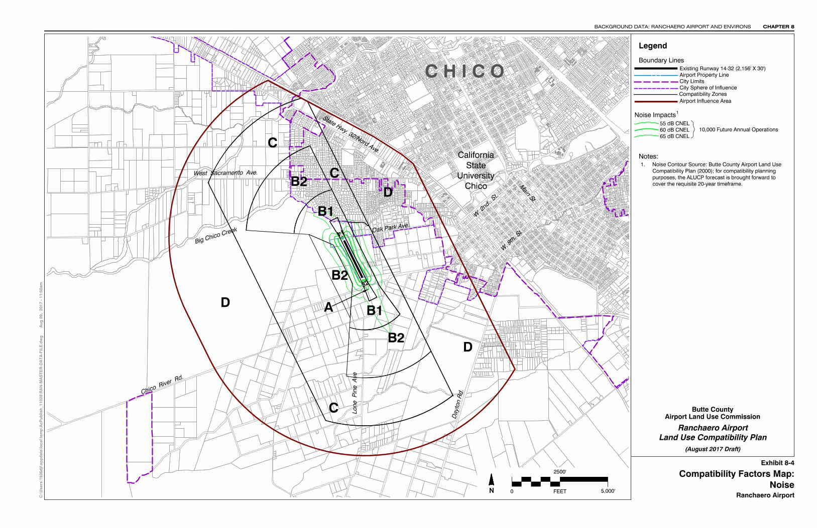
Exhibit 8-4 through 8-7: Compatibility Factors. Depicts the extents of the four compatibility fac-tors upon which the Compatibility Zones for Ranchaero Airport were derived. The four compatibility factors are defined by:
▫ Noise – Future noise contours reflecting an ultimate aircraft activity level of 10,000 annual opera-tions
▫ Safety – Generic safety zones provided in the California Airport Land Use Planning Handbook (October 2011) are applied to the existing runway configurations in the following manner:
· Runway 14-32: Safety zones for a short general aviation runway (length less than 4,000 feet) are applied to the existing and future runway configuration.
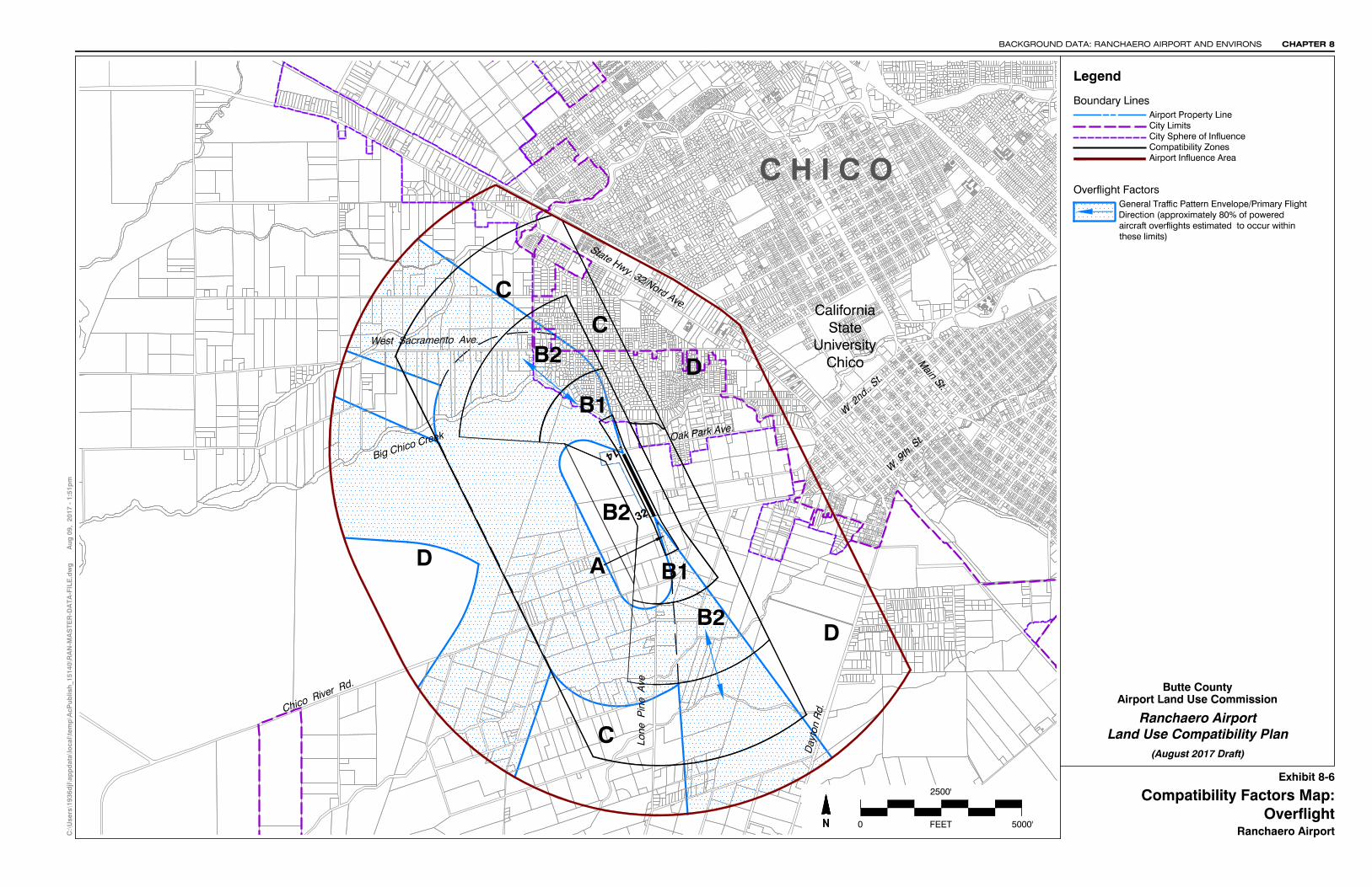
▫ Overflight – Primary traffic patterns reflecting where aircraft operating at the airport routinely fly.
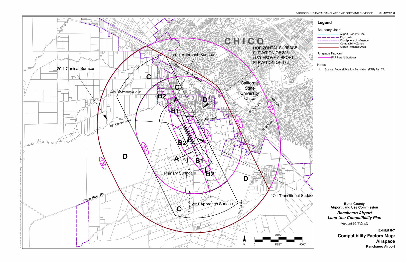
▫ Airspace Protection – Outer boundary of the Obstruction Surfaces as defined by Federal Aviation Regulation (FAR) Part 77, Safe, Efficient Use and Preservation of the Navigable Airspace.
Exhibit 8-8: Airport Environs Information. Summarizes information about current and planned land uses in the environs of the Ranchaero Airport. The status of local general plans and airport land use compatibility policies contained in those plans are also summarized.
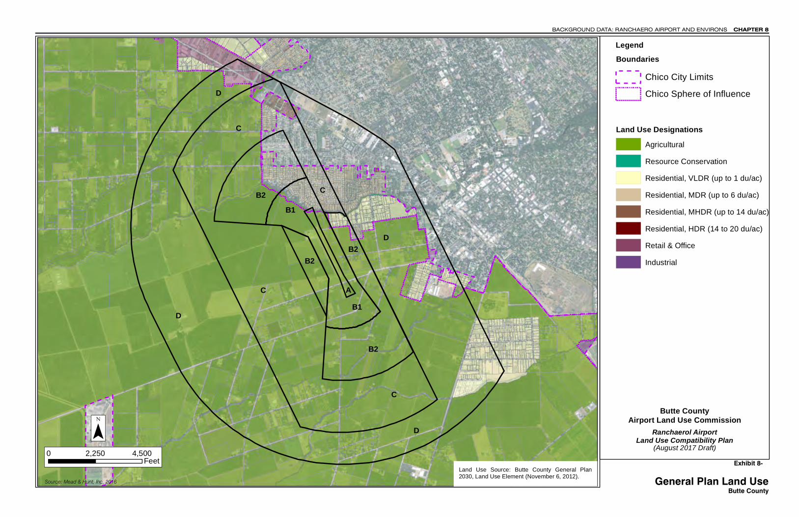
Exhibit 8-9: County of Butte General Plan Land Uses. Shows the planned land use designations as reflected in the Butte County General Plan 2030 Land use Element (amended November 2012).
Exhibit 8-10: City of Chico General Plan Land Uses. Shows planned land use designations as reflected in the adopted Chico 2030 General Plan Land Use Diagram (amended January 2013).
BACKGROUND DATA: RANCHAERO AIRPORT AND ENVIRONS CHAPTER 8
Butte County Airport Land Use Compatibility Plan (August 2017 Draft) 8–3
Exhibit 8-1
Airport Features Summary Ranchaero Airport
GENERAL INFORMATION
Airport Ownership/Use: Private. Permission required prior to landing.
Property Size ▫ Fee title: 23 acres ▫ Object Free Area easements: 2.5± acres ▫ Avigation easements: Data unavailable
Airport Classification: General Aviation, community use
Airport Elevation: 173 feet MSL Access
▫ Via Oak Park Avenue (ends at north end of airport) ▫ State Route 32 (less than 2 miles east)
AIRPORT PLANNING DOCUMENTS
Airport Master Plan ▫ None
Airport Layout Plan ▫ None
PLANNED FACILITY IMPROVEMENTS ▫ None
RUNWAY/TAXIWAY DESIGN
Runway 14-32
Critical Aircraft: Small, single-engine propeller Airport Category/Design Group: Airport Reference Code
A-I (small) Dimensions: 2,156 (from 5010) ft. long, 30 ft. wide
▫ Runway 14 landing threshold displaced 300 ft. ▫ Runway 32 landing threshold displaced 200 ft.
Pavement Strength (main landing gear configuration) ▫ 12,000 lbs. (estimated for aircraft with single-wheel
main gear) Average Gradient: <0.1% Runway Lighting: Nonstandard edge lights Primary Taxiways: Full-length parallel on west
BUILDING AREA
Location: Northwest corner of runway Aircraft Parking Capacity
▫ Hangar spaces for 18± aircraft ▫ Tiedown spaces on grass for 22± aircraft
Services- Airport has one fixed base operator: ▫ Aviation gasoline (self-service) ▫ Flight training and aircraft rental ▫ Charter services; scenic rides ▫ Major aircraft overhaul
APPROACH PROTECTION
Runway Protection Zones (RPZs) ▫ Runway 14: 1,000 feet long, none on airport;
easements on object free area (240 feet from runway end)
▫ Runway 32: 1,000 feet long, none on airport; easement on object free area (240 feet from runway end)
Approach Obstacles ▫ Runway 14: Orchard adjacent to object free area, 10
ft. trees, 200 ft. from runway ▫ Runway 32: Orchard adjacent to object free area, 20
ft. trees, 230 ft. from runway, 1:1 slope to clear
TRAFFIC PATTERNS AND APPROACH PROCEDURES
Airplane Traffic Patterns ▫ Runways 14: Right traffic ▫ Runways 32: Left traffic ▫ Most aircraft landing Runway 14 or departing Runway
32 make close-in turn to avoid overflight of residential area north of airport
▫ Pattern: altitude 973 feet AGL Instrument Approach Procedures (lowest minimums)
▫ None Visual Approach Aids
▫ None Operational Restrictions
▫ Prior permission needed to land ▫ Airport closed at night ▫ Touch-and-goes prohibited ▫ Agricultural operations prohibited ▫ Student pilot solo flights prohibited ▫ Airport surrounded by +20 ft. orchard trees
Notes Sources: Data Compiled by Mead & Hunt (July 2017)

Orchards
Segmented Circle
Office
32
14
Orchards
Orchards
Runway End Elev. 173'
Runway End Elev. 173'
300' Displaced Threshold
200' Displaced Threshold
Hangars
Runway Protection Zone250' x ' 450' x 1000'
Runway Protection Zone250' x ' 450' x 1000'
Residential Area
Exhibit 8-2
Ranchaero Airport
Butte County
(August 2017 Draft)Land Use Compatibility Plan
X:\
0229
700\
1603
29.0
1\TE
CH
\CA
D\R
AN
-MA
STE
R-D
ATA
-FIL
E.d
wg
Aug
09,
201
7 -
10:5
5am
Simplified Airport DiagramRanchaero Airport
CHAPTER 8BACKGROUND DATA: RANCHAERO AIRPORT AND ENVIRONS
Airport Land Use Commission
0 FEET 1000'
500'
Legend
Airport Property Line
Boundary LinesExisting Runway 14-32 (2,156' X 30')Buildings
Prepared By: www.meadhunt.com
CHAPTER 8 BACKGROUND DATA: RANCHAERO AIRPORT AND ENVIRONS
8-4 Butte County Airport Land Use Compatibility Plan (August 2017 Draft)
Exhibit 8-4
Airport Activity Data Summary Ranchaero Airport
BASED AIRCRAFT Current a Future b
2016 2030 Aircraft Type Single-Engine 30 Multi-Engine 0 Turboprop 0
Turbojet 0 Helicopters 4
Total Based Aircraft 34 40
AIRCRAFT OPERATIONS Current a Future c 2016 2030 Total
Annual 5,000 10,000
Average Day, Annual 14 27 Distribution by Operation Type c Locald 25% no Itinerant 75% change
Distribution by Aircraft Type c Single-Engine 90% Multi-Engine <1% Turboprop 0% no Turbojet 0% change Turboprop 0% Helicopter 10%
RUNWAY USE DISTRIBUTION c Current Future 2016 2030 Takeoffs All Aircraft Runway 14 60% no Runway 32 40% change Landings All Aircraft Runway 14 60% no Runway 32 40% change
TIME OF DAY DISTRIBUTION C Day Evening Night All Aircraft Current 95% 4% 1% Future no change
FLIGHT TRACK USAGE c
All Aircraft Estimated 85% of aircraft landing Runway 14 and
departing Runway 32 make close-in turn to avoid overflight of residential area north of airport; other operations follow normal traffic pattern
Notes a Source: Federal Aviation Administration (FAA) Airport Master Record and AirNav.com (July 2017). b Planned aircraft parking capacity of airport c Source: Butte County Airport Land Use Compatibility Plan (2000). For compatibility planning purposes, the forecast is brought forward to cover the requisite 20-year timeframe; future aircraft operations are approximately twice the estimated existing activity levels. d Touch-and-go operations are prohibited, but aircraft remaining in traffic pattern are included as local operations. e Nighttime operations are prohibited. However, operations taking place in daylight early on summer mornings are considered night operations for noise modeling purposes.
Source: Data compiled by Mead & Hunt (July 2017)
C H I C O
CaliforniaState
UniversityChico
Lone
Pin
e A
ve
Day
ton
Rd.
Chico River Rd.
Big Chico Creek
West Sacramento Ave.
Oak Park Ave.
W. 9
th. St.
W. 2
nd.. St.
Main St.
State Hwy. 32/Nord Ave.
C
DB2
C
B1
B2
B1
D
D A
C
B2
Ranchaero AirportNoise
Exhibit 8-4
CHAPTER 8BACKGROUND DATA: RANCHAERO AIRPORT AND ENVIRONS
C:\
Use
rs\1
936d
jl\ap
pd
ata\
loca
l\tem
p\A
cPub
lish
_110
28\R
AN
-MA
STE
R-D
ATA
-FIL
E.d
wg
Aug
09,
201
7 -
11:5
0am
City LimitsAirport Property Line
Boundary Lines
Noise Impacts
60 dB CNEL65 dB CNEL
10,000 Future Annual Operations
Legend
55 dB CNEL
Compatibility Factors Map:
Compatibility ZonesAirport Influence Area
City Sphere of Influence
Ranchaero Airport
Butte County
(August 2017 Draft)Land Use Compatibility Plan
Airport Land Use Commission
32
14
Existing Runway 14-32 (2,156' X 30')
0 FEET
2500'
5,000'
Notes:1. Noise Contour Source: Butte County Airport Land Use
Compatibility Plan (2000); for compatibility planningpurposes, the ALUCP forecast is brought forward tocover the requisite 20-year timeframe.
1
C H I C O
CaliforniaState
UniversityChico
Lone
Pin
e A
ve
Day
ton
Rd.
Chico River Rd.
Big Chico Creek
West Sacramento Ave.
Oak Park Ave.
W. 9
th. St.
W. 2
nd.. St.
Main St.
State Hwy. 32/Nord Ave.
6
6
4
3
3
1
55
2
3
3
4
12
C
DB2
C
B1
B2
B1
D
D A
C
B2
Ranchaero AirportSafety
Exhibit 8-5
CHAPTER 8BACKGROUND DATA: RANCHAERO AIRPORT AND ENVIRONS
X:\
0229
700\
1603
29.0
1\TE
CH
\CA
D\R
AN
-MA
STE
R-D
ATA
-FIL
E.d
wg
Aug
09,
201
7 -
12:5
9pm
City LimitsAirport Property Line
Boundary Lines
Legend
Compatibility Factors Map:
Compatibility ZonesAirport Influence Area
City Sphere of Influence
Generic Safety Zones2
Ranchaero Airport
Butte County
(August 2017 Draft)Land Use Compatibility Plan
Airport Land Use Commission
Short General Aviation Runway (up to3,999') Applied to Runway 14-32. One-sidedtraffic pattern west of airport.
32
14
Existing Runway 14-32 (2,156' X 30')
0 FEET
2500'
5,000'
Runway Protection ZoneInner Approach/Departure ZoneInner Turning ZoneOuter Approach/Departure ZoneSideline ZoneTraffic Pattern Zone
Zone 1Zone 2Zone 3Zone 4Zone 5Zone 6
Runway Factors1
Runway Protection Zone
Notes:1. Runway Protection Zone Source: Butte County Airport
Land Use Compatibility Plan (2000); for compatibilityplanning purposes, the RPZs for a A-I (small) runway isbrought forward for this ALUCP.
2. Safety Zone Source: California Airport Land UsePlanning Handbook (2011).
C H I C O
CaliforniaState
UniversityChico
Lone
Pin
e A
ve
Day
ton
Rd.
Chico River Rd.
Big Chico Creek
West Sacramento Ave.
Oak Park Ave.
W. 9
th. St.
W. 2nd.. S
t.
Main St.
State Hwy. 32/Nord Ave.
C
DB2
C
B1
B2
B1
D
D A
C
B2
Exhibit 8-6
Ranchaero Airport
Butte County
(August 2017 Draft)Land Use Compatibility Plan
LegendC
:\U
sers
\193
6djl\
app
dat
a\lo
cal\t
emp
\AcP
ublis
h_1
5140
\RA
N-M
AS
TER
-DA
TA-F
ILE
.dw
g
A
ug 0
9, 2
017
- 1:
51p
m
OverflightCompatibility Factors Map:
Ranchaero Airport
Overflight Factors
Airport Land Use Commission
City LimitsAirport Property Line
Boundary Lines
Compatibility ZonesAirport Influence Area
City Sphere of Influence
General Traffic Pattern Envelope/Primary FlightDirection (approximately 80% of poweredaircraft overflights estimated to occur withinthese limits)
0 FEET 5000'
2500'
CHAPTER 8BACKGROUND DATA: RANCHAERO AIRPORT AND ENVIRONS
32
14
C H I C O
CaliforniaState
UniversityChico
523
323
323
323
173
523
Lone
Pin
e A
ve
Day
ton
Rd.
Chico River Rd.
Big Chico Creek
West Sacramento Ave.
Oak Park Ave.
W. 9
th. St.
W. 2nd.. S
t.
Main St.
State Hwy. 32/Nord Ave.C
DB2
C
B1
B2
B1
D
D A
C
B2
20:1 Approach Surface
20:1 Conical Surface
7:1 Transitional Surface
Primary Surface
HORIZONTAL SURFACEELEVATION OF 323'(150' ABOVE AIRPORTELEVATION OF 173')
20:1 Approach Surface
Exhibit 8-7
Ranchaero Airport
Butte County
(August 2017 Draft)Land Use Compatibility Plan
FAR Part 77 Surfaces
LegendC
:\U
sers
\193
6djl\
app
dat
a\lo
cal\t
emp
\AcP
ublis
h_1
5140
\RA
N-M
AS
TER
-DA
TA-F
ILE
.dw
g
A
ug 0
9, 2
017
- 1:
53p
m
1. Source: Federal Aviation Regulation (FAR) Part 77.
AirspaceCompatibility Factors Map:
Ranchaero Airport
Airport Land Use Commission
City LimitsAirport Property Line
Boundary Lines
Compatibility ZonesAirport Influence Area
City Sphere of Influence
Notes
Airspace Factors
0 FEET 5000'
2500'
CHAPTER 8BACKGROUND DATA: RANCHAERO AIRPORT AND ENVIRONS
32
14
1

BACKGROUND DATA: RANCHAERO AIRPORT AND ENVIRONS CHAPTER 8
Butte County Airport Land Use Compatibility Plan (August 2017 Draft) 8–5
Exhibit 8-8
Airport Environs Information Ranchaero Airport
AIRPORT LOCATION
Location ▫ Northwestern Butte County ▫ 1 mile west of central Chico
Topography ▫ Situated at 173 feet elevation near western edge of
Sacramento Valley ▫ Surrounding terrain is flat with no significantly higher
elevations within nearly 10 miles
AIRPORT ENVIRONS LAND USE JURISDICTIONS
County of Butte ▫ Areas and immediate environs in county jurisdiction
City of Chico ▫ 1990 city limits within 1.0 miles north and east ▫ Residential area north of airport in city sphere of influ-
ence ▫ Airport and all surrounding lands in city’s planning area
boundary
EXISTING AIRPORT AREA LAND USES
General Character ▫ Orchards immediately around airport ▫ Residential neighborhoods of Chico within 0.2 mile
north and northeast Runway Approaches
▫ North (Runway 14): Orchard 250 feet from runway end; residential subdivision 1,000 feet
▫ South (Runway 32): Orchard 250 feet from runway end; house 800 feet south
Traffic Pattern ▫ Orchards
STATUS OF COMMUNITY PLANS
County of Butte ▫ General Plan 2030 adopted October 2010, amended
November 2012 ▫ Butte County Zoning Ordinance (November 2012)
City of Chico ▫ 2030 General Plan Adopted April 2011 ▫ General Plan Diagram (January 2013) ▫ Zoning map (September 2015)
PLANNED AIRPORT AREA LAND USES
County of Butte ▫ Industrial uses planned adjacent to east and west
sides of airport (Figure LU-7) ▫ Airport and lands west, south, and southeast lie out-
side “greenline” established by County General Plan; “greenline” policy intended to protect agricultural uses beyond line and support urban development on Chico city side
▫ Lands outside “greenline” designated in General Plan agriculture land use (20-ac to160-ac minimum parcel size), consistent with existing uses
▫ Existing residential area inside “greenline” north and northeast of airport designated low density (up to 6 dwelling units per gross acre) and some medium den-sity residential (use (LU-7)
City of Chico ▫ Urban development area boundary on city General
Plan Diagram map coincides with county “greenline” in airport vicinity
▫ Area to north and northeast designated for very-low- and low-density residential (up to 7 dwelling units per gross acre)
CHAPTER 8 BACKGROUND DATA: RANCHAERO AIRPORT AND ENVIRONS
8-6 Butte County Airport Land Use Compatibility Plan (August 2017 Draft)
Exhibit 8-9, continued
ESTABLISHED COMPATIBILITY MEASURES
County of Butte General Plan 2030 ▫ Protect county airports in coordination with the 2000 Air-
port Land Use Compatibility Plan (ALUCP). (Guiding Principles)
▫ Airport Overlay pertains to areas located within Airport Land Use Compatibility Zones described in Section A.3. General Plan 2030 designations located within these zones are subject to additional land use restrictions un-der the 2000 ALUCP. (LU, Overlays)
▫ Consider 2000 ALUCP in General Plan and Zoning deci-sions and be consistent with it. (LU-P12.5)
▫ Recommend Butte County and Airport Land Use Com-mission update the Butte County ALUCP. (LU-A12.3)
▫ Private airstrips and landing fields shall be located out-side of flight paths to and from existing airports so that they do not present a hazard or annoyance to neighbor-ing areas. (CIR-P11.1)
▫ New noise-sensitive land uses shall not be located within the 55 Ldn contour of airports, except Chico Mu-nicipal Airport. (HS-P1.3)
▫ Refer all developments which may impact upon any agri-cultural aviation operation to Butte County Airport Land Use Commission (ALUC) for review. (D2N-P1.13)
▫ Through Butte County ALUC, develop comprehensive land use recommendations to reduce potential conflicts between desired land uses and agricultural aviation ac-tivity. (D2N-P1.15)
Butte County Zoning Code ▫ Airport (AIR) zone preserves and protects Butte
County’s airports by allowing land uses and activities that are typically associated with airport operations, and preventing the encroachment of incompatible land uses. Max FAR is 0.5. (Section 24-28B)
▫ Airport Compatibility (AC) overlay zone identifies land within unincorporated Butte County where additional re-quirements apply to ensure the compatibility of land uses and development with nearby airport operations. The AC overlay zone coincides with the Airport Influence Area designated in the Butte County ALUCP. All devel-opment projects and land use actions proposed within the AC overlay zone shall comply with the ALUCP crite-ria, excluding those criteria specifically overruled by the Board of Supervisors in accordance with Public Re-sources Code Section 21676. (Section 24-33)
City of Chico 2030 General Plan ▫ Protect Chico Municipal and Ranchaero Airports, and
promote development in the Airport Industrial Park. (LU-7)
▫ Safeguard Chico Municipal and Ranchaero Airports from intrusion by uses that could limit expansion of air-port services, and prohibit devt that poses hazards to aviation. (LU-7.1)
▫ Amend City’s Municipal Code and Zoning Map to im-plement airport overflight zoning district overlays con-sistent with Butt County ALUCP (LU-7.1.1)
▫ Policy LU-7.2 (development in the Airport Vicinity)- Promote airport-related and other compatible develop-ment in the Airport Industrial Park
▫ Plan for and promote a full range of aviation services and facilities that meet the present and future needs of residents and the business community. (CIRC-6)
▫ Support safe airport operations and maximize public safety in the vicinity of airports. (S-6)
▫ Promote safe air operations by limiting the height of structures and regulating uses that would have ad-verse impacts on airport safety. (S-6.1)
▫ Continue to consider relevant public safety factors prior to approving development projects in the vicinity of airports. (S-6.2)
City of Chico Zoning Code ▫ Code establishes four airport-related zoning districts:
Aviation, Airport-Commercial, Airport-Manufactur-ing/Industrial and Airport-Public Facilities. (Chapter 19.48)
▫ Airport Environs (AE) overlay district regulates land uses that may affect navigable airspace consistent with FAR Part 77. (Section 19.52.020)
▫ Airport Operations (AO) overlay zone regulates land uses in the vicinity of airports consistent with the Butte County ALUCP. (19.52.030)
Source: Data Compiled by Mead & Hunt (July 2017)
B1
B2
A
D
D
D
C
C
C
B2
B2
C
D
B1
B2
Source: Mead & Hunt, Inc. 2016
0 2,250 4,500Feet
¯Land Use Source: Butte County General Plan2030, Land Use Element (November 6, 2012).
(August 2017 Draft)Exhibit 8-
General Plan Land UseButte County
CHAPTER 8BACKGROUND DATA: RANCHAERO AIRPORT AND ENVIRONS
Ranchaerol AirportLand Use Compatibility Plan
Butte CountyAirport Land Use Commission
BoundariesChico City LimitsChico Sphere of Influence
Land Use DesignationsAgriculturalResource ConservationResidential, VLDR (up to 1 du/ac)Residential, MDR (up to 6 du/ac)Residential, MHDR (up to 14 du/ac)Residential, HDR (14 to 20 du/ac)Retail & OfficeIndustrial
Legend

B1
B1
B2
A
D
D
D
C
C
C
B2
B2
B2
C Diamond Match
Bell / Muir
Source: Mead & Hunt, Inc. 2016
0 2,500 5,000Feet
¯ Ranchaero AirportLand Use Compatibility Plan
Legend
Residential
Commercial
Office and Industrial
Public and Open Space
Special Areas
Resource Constraint Overlay
VLDR Very Low Density ResidentialLDR Low Density ResidentialMDR Medium Density ResidentialMHDR Medium-High Density ResidentialHDR High Density ResidentialRMU Residential Mixed Use
NC Neighborhood CommercialCMU Commercial Mixed UseCS Commercial Services
OMU Office Mixed UseIOMU Industrial/Office Mixed UseMW Manufacturing & Warehousing
PFS Public Facilities & ServicesPOS Primary Open SpaceSOS Secondary Open Space
SPA Special Planning Area
VLDR/RCOLDR/RCOMDR/RCOMHDR/RCOCMU/RCOOMU/RCOMW/RCO
Land Use Designations
(August 2017 Draft)Exhibit 8-
General Plan Land UseCity of Chico
CHAPTER 8BACKGROUND DATA: RANCHAERO AIRPORT AND ENVIRONS
Butte CountyAirport Land Use Commission
Land Use Source: CIty of Chico General PlanDiagram ( January 1, 2013).
BoundariesSpecial Planning AreasChico City LimitsChico Sphere of Influence Boundary