Embed Size (px)
Citation preview

79 Elm Street • Hartford, CT 06106-5127 www.ct.gov/deep Affirmative Action/Equal Opportunity Employer Office of Adjudications
IN THE MATTER OF : APPLICATION NO. 200801981-KB DANIEL McLEOD : MAY 15, 2014
PROPOSED FINAL DECISION
I SUMMARY
Daniel McLeod has filed an application with the Department of Energy and Environmental Protection (DEEP/Department) for a permit to conduct activities waterward of the coastal jurisdiction line in accordance with General Statutes § 22a-361, the Structures, Dredging, and Fill Act. The Commissioner of Energy and Environmental Protection directed that a public hearing on this application be held in accordance with the determination that it would serve the public interest. The parties to this matter are the applicant, DEEP staff, and the intervening parties, Wallacks Point Association, Inc. (WPA) and Christopher Buckley.1 The proposed activity consists of repairs to an existing seawall and concrete pier and the construction of a dock structure extending from the end of the existing concrete pier. The dock structure includes a pile-supported pier extension, a ramp, and a pile-supported floating dock. The proposed structure is intended to provide recreational boating access to Long Island Sound at property owned or controlled by the applicant located at 36 Wallacks Drive and 411 Soundview Avenue in Stamford. The hearing in this matter consisted of prehearing meetings with the parties, site visits conducted at low and high tide, an evening hearing in Stamford for the collection of public comment on the record and several days of continued evidentiary hearings in Hartford for the
1 Christopher Buckley was granted party status in this matter under § 22a-19 of the General Statutes as an individual and as Trustee of the William F. Buckley, Jr. Revocable Trust. During the course of the hearing, Mr. Buckley’s counsel withdrew from this matter at his request. As an intervening party, Mr. Buckley provided direct testimony during the hearing but confirmed on the record that his concerns focused on another application (Tr. 9/10/13 p. 28) He did not avail himself of further opportunities to support his opposition or claim under § 22a-19 with legal arguments or specific references to the record in a post-hearing filing. It can be argued he has abandoned his claims by failing to adequately brief them. See Lane v. Commisioner of Environmental Protection 136 Conn.App. 136, 159 (2012). However, Mr. Buckley’s allegations under 22a-19 were identical to those made by WPA. Regardless of whether he abandoned his claims, they received full consideration in this decision and the findings and conclusions in this decision apply equally to those claims.
2
collection of witness testimony and documentary evidence from the parties. After the conclusion of the hearing and in accordance with the post-hearing directive, the parties filed post-hearing briefs for my consideration. In particular, DEEP staff and the applicant filed suggested findings of fact and conclusions of law for my consideration and adoption as part of the proposed final decision. WPA filed a summary of their objections to issuance of the proposed draft permit. I have reviewed the record in this matter, including the documentary evidence, witness testimony, and the public comment. Following this review, I conclude that the applicant, through the presentation of substantial evidence, has demonstrated that the proposed activity, if conducted in accordance with the proposed draft permit as modified by this decision, complies with the relevant statutory and regulatory requirements, namely the Structures Dredging and Fill Act (General Statutes §§ 22a-359 through 22a-363) and the applicable portions of the Coastal Management Act (General Statutes § 22a-90 through 22a-112). The joint submission provided by DEEP and the applicant is generally supported by the hearing record. Although the joint findings are not adopted in their entirety, this decision incorporates portions of the joint submission while combining and reformatting certain findings based on my review of the record and my determination of which joint findings I found relevant and necessary to support my decision. In addition, I have made some additional findings based on the witness testimony and documentary evidence to further support the conclusions of law.2 The applicant has demonstrated that the proposed dock structure and its component parts if constructed in compliance with the proposed permit terms and conditions as modified by this decision, would comply with the applicable statutes and regulations. I therefore recommend issuance of the proposed draft permit (Attachment 1) with the modifications recommended by this decision.
II
DECISION A
FINDINGS OF FACT
1. On July 18, 2008, Daniel McLeod (the applicant), filed an application for approval of a residential dock and repairs to an existing seawall at real property known as 36 Wallacks Drive, in Stamford, Connecticut. As his consultant, Ocean and Coastal Consultants, Inc. ("OCC"), completed the application forms and submitted the application to DEEP on the applicant’s behalf. (Exs. DEEP-M-1; test. A. Sleicher, 7/25/13, p. 196; D. McLeod, 7/25/13, pp. 27, 66, 76; and K. Bellantuono, 7/31/13, p. 67.) 2. The residential dock and certain seawall repairs that are the subject of this proceeding are proposed for 36 Wallacks Drive. Certain repair work to a seawall located on property
2 The joint submission is not attached to this document because I have elected not to refer directly to it.

3
adjacent to 36 Wallacks Drive known as 411 Soundview Avenue in Stamford is also included in the application that is the subject of this proceeding. (Ex. DEEP-M-38; test. A. Sleicher, 7/25/13, pp. 160, 213-214, D. McLeod, 7/25/13, p. 17.) 3. The Estate of Marie A. Burns is the owner of 36 Wallacks Drive. The applicant, Mr. McLeod, is the executor and sole beneficiary of The Estate of Marie A. Burns. (Exs: DEEP-M-1, APP-M-1(A), APP-M-1(B), APP-M-1(C), and APP-M-1(D); test. D. McLeod, 7/25/13, pp. 18-20.) 4. At the time of the filing of the application, 411 Soundview Avenue was owned by 411 Soundview Avenue, LLC, which is a Connecticut limited liability company. Mr. McLeod is a member of 411 Soundview, LLC. On June 20, 2013, 411 Soundview Avenue, LLC quitclaimed its interest in 411 Soundview Avenue to Mr. McLeod, individually. Mr. McLeod currently owns 411 Soundview Avenue. (Exs. DEEP-M-1, APP-M-2, and APP-M-29; test. D. McLeod, 7/25/13, pp. 22-24, 74.) 5. 36 Wallacks Drive and 411 Soundview Avenue, (collectively, the subject property) are residential properties with single-family residences and accessory structures. (Exs. DEEP-M-1 and HO-1.) 6. There is an existing concrete pier structure located at 36 Wallacks Drive that is approximately eighty-one feet in length, which has been present at the subject property since at least 1934 as depicted on historic aerial photographs. The existing concrete structure is located toward the center of the subject property adjacent to Long Island Sound. Prior to 1957, the existing concrete pier had a timber pier extension that extended out an additional eighty-nine feet for a total pier structure of approximately one hundred and seventy feet. This timber pier structure was located over a rubble groin that remains at the subject property today. The timber portion of the pier was removed sometime between 1957 and 1965 as depicted on historic aerial photos. Historic aerial photographs from 1934, 1965 and 1995 demonstrate that conditions at the location of the existing concrete pier and rubble groin area have remained largely unchanged since 1934 with the exception of the removal of the wooden pier sometime after 1957. (Exs. DEEP-M-1, M-8, M-30, APP-M-4, M-5; test. A. Sleicher, 7/25/13, pp. 161, 163-166, W.F. Bohlen, 7/26/13, p. 97.) 7. The subject property is located on the westerly shore of Cove Harbor within a residential neighborhood known as Wallacks Point in Stamford. Most of the area along the western shore of Cove Harbor has evidence of historic groins and jetties, including the subject property and its existing concrete pier. The area along Cove Harbor is developed with approximately eleven man-made structures. The subject property, like many of the properties located on Long Island Sound, including those with permitted docks, is within a Flood Hazard Zone VE, as provided by the Federal Emergency Management Agency (FEMA). (Exs. DEEP-

4
M-1, M-8, M-37, APP-M-4, M-5, HO-1; test. A. Sleicher, 7/25/13, pp. 161-166, 168 and 9/11/13, pp. 34-36, W.F. Bohlen, 7/26/13, pp. 97, 121, K. Bellantuono, 7/31/13, pp. 65, 67.) 8. The subject property's shoreline has a sandy beach area located along the waterfront. This sandy beach area is under water during high tide periods. The subject property's beach face is armored with stone masonry seawalls along their respective shorelines. There is no coastal vegetation on the subject property. There are no tidal wetlands found on or adjacent to the subject property, nor any submerged aquatic vegetation. (Exs. DEEP-M-1, M-37, M-38; test. M. Raymond, 7/30/13, pp 169-70, 196, 200-01, K. Bellantuono, 7/31/13, pp. 63-65, 119, T. Baptist, 7/30/13, pp. 111-112, M. Ludwig, 7/30/13, p. 56, J. Dickson, 8/9/13, p. 30.) 9. The Cove Island Wildlife Sanctuary ("CIWS") is located to the north of the subject property on a historic municipal bulky waste facility. Within the southern portion of the CIWS, bordering on Cove Harbor, is an area that has been designated as an Important Bird Area ("IBA") by the National Audubon Society. The CIWS provides area for some, but not all, migrant bird species. An IBA designation is intended to assist regulators and landowners in making decisions for using the specific property area designated as IBA. There is a more natural shorefront at the CIWS on Cove Harbor, which has not been affected over the years by the man-made groins structures along the westerly side of Cove Harbor to the south of the CIWS. (Exs. DEEP-M-8, M-15, M-18, APP-M-5, HO-1; test. W.F. Bohlen, 7/26/13, pp. 100-101, M. Ludwig, 7/30/13, p. 78, T. Baptist, 7/30/13, p. 147, 156-57, J. Dickson: 8/9/13, pp. 11-13, 44-45, 61-62.) 10. Adjacent to the CIWS is a municipal park that includes a large marina with approximately two hundred boat slips, a boat launch, public beach, recreational ball fields with lights, a skating rink facility and a paved parking area to accommodate its guests. This municipal park has not had an adverse impact upon the CIWS relative to bird habitat or affected its status as an IBA. (Ex. HO-1; test. D. McLeod, 7/25/13, pp. 41-42, A. Sleicher, 7/25/13, p. 201, T. Baptist, 7/30/13, p. 109, D. Winston, 9/9/13, p. 193.) 11. There is a channel in Cove Harbor that provides access to Long Island Sound from the marina and the public boat launch at the municipal park. This channel is not federally designated or maintained and is located approximately five hundred twenty-seven feet to the east of the terminus of the applicant’s proposed residential dock. The channel is located in a "no wake" zone. This channel and its use has not had an adverse impact upon the CIWS and associated bird habitat. The proposed structure will not interfere with navigation in the proposed channel and will not interfere with anyone navigating between the channel and the location of the proposed structure. (Exs. DEEP-M-8, APP-M-7, M-13(A), M-13(B); test; K. Bellantuono, 7/31/13, p. 123, A. Sleicher, 7/25/13, pp. 173, 195, 201-02, D. Winston, 9/9/13, pp. 190-91.)

5
12. The applicant has proposed to construct a steel framed pier extending from the existing concrete pier measuring four feet by seventy-five feet, which will connect to a three foot by thirty-one foot aluminum ramp, which in turn will connect to a one hundred s ixty square foot floating dock measuring eight feet by twenty feet. The total length of the proposed residential dock is one hundred twenty- three feet and six inches from the end of the existing concrete pier for a total length of approximately two hundred four feet and six inches from shore including the existing concrete pier. The dock will be located on 36 Wallacks Drive. The application also proposes repair work to the existing seawall located on 36 Wallacks Drive. During the DEEP review process, the application was revised to include repair work to a seawall located on the adjacent property at 411 Soundview Avenue. (Exs. DEEP-M-1, M-38; test. A. Sleicher, 7/25/13, pp. 160, 213-215, M. Ludwig, 7/26/13, pp. 218-219, 7/30/13, pp. 68-69.) 13. The proposed pier will be supported by three sixteen-inch diameter steel piles, rock-socketed into the ledge rock and glacial till below grade within the area of the existing rubble groin, based upon soil borings taken at the subject property. The purpose of the proposed residential dock is to provide berthing space for a boat, and permit Mr. McLeod access to Long Island Sound for recreational boating and fishing. The boat will be berthed on the north side of the float where there are no aquatic or shellfish resources. The berthing area is beyond the existing rubble groin and has a sandy bottom. (Exs. DEEP- M-1, M-38; test. A. Sleicher, 7/25/13, pp. 186-87, 9/11/13, pp. 26-27, D. McLeod, 9/11/13, pp. 66-67, M. Ludwig, 9/11/13, p. 53, M. Raymond, 9/11/13, p. 60.) 14. The floating dock will be supported by four twelve-inch steel piles rock-socketed into the ledge rock or glacial till below grade. The initial application proposed a floating dock measuring eight by twelve and one half feet to be in line with the OLISP guidelines that recommend a floating dock no larger than 100 square feet. A wave analysis conducted by OCC indicated that typical wave action, including regular wake action from passing boats, would impact the stability of the floating dock as initially proposed. Based on this analysis and discussions with OLISP Staff, the applicant proposed increasing the size of the dock from one hundred square feet to one hundred and sixty square feet. As a result, the proposed dock will measure eight feet by twenty feet for better stability. (Exs. DEEP-M-30, M-38; test. A. S le icher , 7/25/13, pp. 213-215.) 15. The steel framed pier, pier support piles and the four piles for the floating dock are designed to withstand the one hundred year storm event and events comparable to the recent storms known as Irene and Sandy that occurred in 2011 and 2012 respectively. (Test. A. Sleicher, 7/25/13, pp. 192-93 and 7/26/13, p. 90.)

6
16. Final detailed construction plans for the steel framed pier and piles for the floating dock, as well as all other dock components, are not required to be submitted with the application, but the permit requires the applicant to submit "as-built” drawings to OLISP once the dock is constructed. If the constructed dock does not comply with the permit requirements and conditions, OLISP may take measures to ensure that the applicant adheres to the permit requirements and conditions. (Ex. DEEP-M-40, test. A. Sleicher, 7/26/13, pp. 80-82, K. Bellantuono, 9/11/13, pp. 76-78.) 17. The substrate located in the vicinity of the proposed dock is comprised mostly of coarse to medium sand, a little bit of silt, no significant rocks that would prevent a boat berthing at the proposed dock, and no significant coastal resources. (Ex. APP-M-12; test. M. Ludwig, 9/11/13, pp. 52-53, A. Sleicher, 9/11/13, pp. 26-27.) 18. The application indicated that the mudline elevation at the proposed float is -4.6 feet NGVD 29, with a water depth of 1.7 feet or 20.4 inches at mean low water ("MLW"), and nine feet at mean high water ("MHW"). This information was based upon then available data from the Army Corps of Engineers, entitled "Tidal Flood Profiles of the New England Coastline," dated 1988. Updated water depth information from an additional NOAA resource known as the "Vertical Datum and Transformational Tool" became available after the application was filed. Using site specific latitude and longitude, the resource provides elevation data for mean low water. OCC’s use of the tool indicated that an additional 2.4 inches of water depth is available at the terminus of the proposed dock where the boat will be berthed. An additional 2.4 inches of water depth would provide 22.8-24.0 inches of water across the terminus of the dock area during mean low water and during mean low low water conditions there is approximately 20.4 to 21.6 inches of water across the terminus of the dock area for most of the tidal cycle. There is adequate water depth to launch and retrieve a boat at the proposed dock. The depths at the location of the proposed floating dock have the potential to shift due to the influence of tidal forces and the dynamic nature of the area. The mean low water line has been observed to have moved closer to shore in the area of the proposed floating dock since the filing of the original application and further from shore in other areas on either side of the proposed structure due to deposition of materials by tidal forces. Water depths may increase or decrease near the subject property given the potential influence of tidal forces. (Exs. APP-M-35, M-36, and M-37, INT-166, 167; test. A. Kreuzkamp, 9/10/13, pp. 58-59, 103, A. Sleicher, 9/11/13, pp. 7-14, 20-22.) 19. On occasion, during extreme low tide events, any boat berthed at the floating dock may rest on the sandy bottom for short periods of time that will generally not exceed thirty minutes without causing damage to the boat or an adverse impact to any coastal resource, including the substrate. Generally, these times of extreme low tide correspond with an increased tidal rate. The occasional periods that the boat touches the substrate will be

7
minimized by the increased rate at which the water depth will increase. There is nothing unique about this aspect of the dock, especially since this occurrence will not result in an adverse impact to any coastal resource. The applicant understands that the depth limitations at the site of the proposed structure will impact the selection and use of a vessel to be regularly berthed at the proposed dock. (Exs. DEEP-M-1, M-38; test. A. Sleicher, 7/26/13, p. 53, 9/11/13, pp. 24-28, M. Ludwig, 7/31/13, p. 11, 9/11/13, p. 53, M. Raymond, 9/11/13, pp. 59-60, K. Bellantuono, 9/11/13, pp. 71-73, D. McLeod, 66-67, 88-89.) 20. The dock could not be extended further into deeper waters because the nearest deeper water is only located in and adjacent to the existing channel that provides the access to and egress from the Cove Island Marina. Such an extension would impact navigation in the channel and impact smaller vessel traffic, especially paddle craft, navigating outside the channel. (Ex. APP-M-7; test. A. Sleicher, 9/11/13, p. 33, D. McLeod, 9/11/13, p. 65.) 21. OLISP's residential dock guidelines recommend that any fixed pier terminates at mean low water, and that any ramp and floating dock extend no more than forty feet past mean low water. The proposed ramp and floating dock extend approximately fifty feet beyond mean low water. Because of the rubble groin remains and shallow depths of the waters at the terminus of the existing concrete pier, extending the dock beyond the forty foot length recommended by the guidelines is required to provide reasonable access to the waters of Long Island Sound with no adverse impact to a coastal resource or significant impact to navigation, or public access. For these reasons, OLISP determined that the proposed additional dock length of ten feet, for a total of fifty feet beyond mean low water, is appropriate considering the site conditions, water depths, and minimal impact associated with the extension. (Exs. DEEP-M-1, M-38; APP-M-14, M-15; test. A. Sleicher, 7/25/13, pp. 212-13 and K. Bellantuono, 7/31/13, pp. 89-91.) 22. The Army Corps of Engineers ("ACOE”) recommended that the proposed floating dock have float stops installed on the pilings to ensure at least eighteen inches of clearance for the floating dock above the substrate during all tides. This will further mitigate any potential impacts to the substrate located under the floating dock during tide events. Mr. McLeod consents to this requirement being added as a Special Term and Condition for his permit approval. (Exs. DEEP-M-43 and APP-M-28; test. A. Sleicher, 7/25/13, p. 222, M. Raymond, 9/11/13, p. 62, M. Ludwig, 7/30/13, pp. 70-71, 9/11/13, p. 56, D. McLeod, 7/25/13, p. 90.) 23. The DEEP Bureau of Natural Resources maintains a Natural Diversity Data Base (NDDB) listing species in Connecticut noted as species of special concern, threatened species, and endangered species. Three avian species listed in the NDDB, the American Oystercatcher, the Brown Thrasher, and the Common Tern, occur in the vicinity of the proposed dock. The American Oystercatcher is a threatened species while the Common Tern

8
and Brown Thrasher are both species of special concern. The subject property does not provide nesting habitat for any of these species. The shoreline areas on the subject property are not viable nesting areas for the American Oystercatcher and the Common Tern because they are covered by water during the higher end of the tidal cycle. The American Oystercatcher and Common Tern generally nest on offshore islands. The Brown Thrasher is an upland species not associated with a beach or dune habitat and requires dense thickets for nesting habitat. The proposed dock will not impact the nesting habitat of these three species. (Exs. DEEP-M-15, M-33, M-38; test. T. Baptist: 7/30/13, pp. 114, 153-155, M. Ludwig, 7/26/13, pp. 200-201, 208-212; 7/30/13, pp. 49-52, 82; J. Dickson, 8/9/13, pp. 23-24, 27, 35-36, 68-69, 72, K. Bellantuono, 7/31/13, pp. 213-214, 8/8/13, p. 75.) 24. Several species of shoreline birds may use the beachfront area in the vicinity of the proposed structure as limited foraging habitat, including the American Oystercatcher and the Common Tern. The proposed structure may limit the use of the subject property as foraging habitat on a temporary basis during construction. Foraging and roosting areas on the subject property are limited. There will be no permanent impact to the limited foraging habitat on the subject property. The proposed structure may provide a roosting area after its construction for shore birds, including the American Oystercatcher. (Ex. DEEP-M-15; test. T. Baptist, 7/30/13, pp. 113-14, 120-23, 159-161, J. Dickson, 8/9/13, p. 39.) 25. There is the potential for bird nesting areas located to the north of the subject property within the CIWS. The minimal activities associated with the proposed residential dock will not adversely impact bird habitat on adjacent properties or properties in the area including the CIWS. (Test. J. Dickson, 8/9/13, p. 28-29, 36-39, 57, 95, M. Ludwig, 7/30/13, pp. 88, 7/26/13, 204, 213; and T. Baptist, 7/30/13, pp. 114-117.) 26. No work for constructing the pier and dock structure will be conducted between May 1st and August 30th of any calendar year. This condition and timeframe will protect the habitat and potential feeding areas for the American Oystercatcher, Brown Thrasher and Common Tern from any potential impacts. (Ex. DEEP-M-40, Special Term and Condition #3; test. K. Bellantuono 7/31/13, pp. 77-79, 115-116, 120, M. Raymond, 7/30/13, pp. 169-171, T. Baptist, 7/30/13, pp. 111-115, J. Dickson, 8/9/13, pp. 19, 23-24, 34-35.) 27. There are documented diamondback terrapins in Cove Harbor. The diamondback terrapin is not a threatened or endangered species, or species of special concern. The subject property is not suitable habitat for the diamondback terrapin because the subject property is inundated with water during high tide events. The proposed dock will not likely have any population level impacts for the diamondback terrapins. (Test. J. Dickson, 8/9/13, p. 31, 39.)

9
28. There are shellfish beds in the area of the proposed structure and opportunities for recreational shell fishing in the intertidal area. However, there is currently a prohibition against recreational shellfishing in the area, including the subject property. This prohibition is attributed to contamination from Holly Pond, which is located to the north of Cove Harbor. This prohibition is expected to remain in effect into the foreseeable future. Typically, a permit for a structure from DEEP would require placement of signage indicating that recreational shellfishing is allowed in the area of the structure. However, given the prohibition in effect and to protect against human consumption of shellfish in the area, signage should be posted on the proposed residential dock and kept for the duration of the closure period warning against harvesting or taking shellfish. (Exs. DEEP-M-34, M-40, APP-M-9; test. K. Bellantuono, 7/31/13, pp. 104-106, M. Ludwig, 7/26/13, pp. 139-145, M. Raymond, 7/30/13, pp. 202-203.) 29. There is no dune area on the subject property. There is a small dune shelf that commences on the northerly end of the Steinberg property that extends into the CIWS. The Steinberg property abuts the northerly end of 411 Soundview Avenue. There is some dune vegetation on this dune shelf known as American Beachgrass. There is no evidence of Panicum amarum (or coastal panic grass) currently located on the subject property. There is no evidence of any rare plant species within the CIWS. The activities associated with the construction and use of the applicant’s residential dock will not adversely impact the American Beachgrass located on the CIWS property to the north, or any coastal panic grass or its habitat that may be located north of the subject property. (Ex. DEEP-M-1; test. M. Raymond, 7/30/13, pp. 176-180, 187-190, J. Dickson, 8/9/13, pp. 30, 41-42, 87-90, K. Bellantuono, 8/8/13, p. 86, M. Ludwig, 7/30/13, pp. 92-93.) 30. Caritas Island is the headland in the south. The small peninsula of land that is the border of the eastern side of the municipal marina is the headland to the north. The net drift of sediment in Cove Harbor is from the south to the north. This is evidenced by the fillets along the south side of the groins on the properties located to the south of the subject property, and to the south of the existing concrete pier on the subject property. Most of the year, the winds and tidal currents are from the west and have small influences on sediment drift in Cove Harbor. Storm events may occur from the south or east. As designed, the dock will minimize any obstruction to waves or currents. The steel pier has three piles each located in the center of the pier. These three piles will be driven into the existing rubble mound at the terminus of the existing concrete pier. As designed, the steel pier's three piles, as well as the four piles to support the floating dock, will minimize exposure to wave and currents. (Test. W.F. Bohlen, 7/26/13, pp. 101-106, M. Raymond, 7/30/13, pp. 179-180, M. Ludwig, 7/26/13, p. 146.) 31. There may be some temporary disturbance during construction of the dock, and small, localized disturbances at the piles once constructed. Once constructed, the sediment transport

10
regime at the proposed dock will continue as it exists today. Because of its small size and design, the residential dock will have an insignificant effect, and no adverse impact, upon sediment transport at the subject property and in Cove Harbor. (Exs. DEEP-M-1, M-8, M-30, M-38, and HO-1; test. M. Ludwig, 7/26/13, p. 131, W.F. Bohlen, 7/26/13, pp. 102-106, A. Sleicher, 7/25/13, pp. 187-188, D. McLeod, 7/25/13, pp. 120-121, and K. Bellantuono, 7/31/13, pp. 97, 119-121, 8/8/13, pp. 60, 191.) 32. Currently, the existing concrete pier restricts pedestrian access along the public trust area during high tide. Pedestrian access is available along the public trust area during low tide at the end of the concrete pier. This will remain the case after the proposed dock is constructed. At low tide, the dock's elevation provides 6.4 feet of clearance underneath the dock to allow pedestrian access around the existing concrete pier at low tide to continue as it exists today. At mean high water, the dock's elevation provides three feet of clearance underneath the dock for small recreational vessels such as kayaks to navigate, if required. Therefore, public access to the public trust area will not be adversely impacted by the proposed dock. (Exs. DEEP-M-1, M-8, M-30 and M-38; test. A. Sleicher, 7/25/13, pp. 187-189, 7/26/13, p. 74, K. Bellantuono: 7/31/13, p. 102.) 33. The applicant studied several alternatives to the proposed pier and dock structure as a means to gain access to the waters of Long Island Sound from the upland property. These alternatives included: use of a harbor master approved mooring, use of a boat lift at the terminus of the existing concrete pier, use of a clothesline mooring at the end of the concrete pier, and use of a ship’s ladder at the end of the concrete pier. The alternatives that rely on placement of a mooring or boat lift at the end of the concrete pier will not provide reasonable access to the water. The area at the end of the pier is without adequate water depth for significant portions of the tidal cycle and would not allow regular placement of a vessel at this location. In order to reach adequate water depths, it is necessary to extend beyond the rubble at the end of the concrete pier and out to the area of the proposed floating dock. Continuation of the concrete pier with a pile-supported structure provides the necessary access and minimizes impacts. (Ex. DEEP-M-30; test. A. Sleicher, 7/25/13, pp. 208-09, 216-22, K. Bellantuono, 8/8/13, pp. 26-27, 47-49.) 34. A harbor master-approved mooring will rely on the use of an anchor placed on the bottom and a length of chain needed to provide the vessel with enough room to swing around the mooring anchor. The chain is intended to also rest on the bottom and will drag along the substrate as the boat is moved by current and wind. The applicant currently has a mooring anchor but its current location is not sufficient to permanently moor a boat due to depth constraints. Any boat would likely run aground regularly if placed permanently on the current harbor master-approved mooring at the subject property. The use of a mooring for boating access would require its placement significantly further into the waters of Long
11
Island Sound to avoid impacts to the bottom from a vessel regularly running aground. Even with significant water depth, a mooring will still require a length of chain that will consistently lie on and drag along the bottom to provide the boat the ability to swing around its mooring anchor. (Test. D. McLeod, 7/25/13, 34-37, 41, 100-01, 122, 9/11/13, pp. 65-66 M. Ludwig, 7/26/13, pp. 151-58, 7/31/13, p. 27, 9/11/13, pp. 53-54.) 35. An upland property owner’s use of a pile supported structure will avoid the impacts to the substrate that can occur with a mooring anchor and chain. The impact from the mooring chain covers a wide area surrounding the mooring anchor. Impact to the substrate from the fixed pier are minimized and associated only with the area of the pile installation. Placement of a mooring in deeper water would likely impact users of the navigation channel to the east of the proposed structure and could impact leased shellfish beds. (Exs. HO-1, APP-M-7, APP-M-9; test. A. Sleicher, 7/26/13, pp 219, M. Ludwig, 7/26/13, 151-58, 178, 7/31/13, p. 27, 9/11/13, pp. 53-54.) 36. After the initial filing of the application, it is typical for DEEP staff to review the proposed activity and seek additional information from an applicant to support the proposed activity. In addition, DEEP staff will forward comments received from members of the public or from other divisions within DEEP and seek a response from the applicant to those comments. The application in this matter was reviewed by staff and staff requested additional information from the Applicant. The application was handled in accordance with typical practices by agency staff. Staff presented the applicant with a request for additional information on thirteen topics. It is typical for staff to seek this amount of information. DEEP has altered its application process since this application was initially filed. Staff now attempts to have most of these questions answered during a pre-application review process before the filing of the final application. (Ex. DEEP-M-28; test. K. Bellantouno, 7/31/13, pp 81-86, 93-107.) 37. The proposed structure includes removable parts, namely the ramp and the floating dock that can be located on the upland in the event of a significant storm in the forecast or on a seasonal basis. The aluminum ramp structure and floating dock can be disengaged from the steel framed pier, brought to the public ramp at the marina located immediately to the north of the subject property, and removed from the water. The same can be accomplished to accommodate winter storage of these dock components. Any boat berthed at the dock can similarly be removed. The applicant understands the options available to him to remove these structures as a means to protect his property and the property of others. Any assistance needed to remove these portions of the proposed structure can be provided by a marine contractor in the regular course of business. (Test. D. McLeod, 7/25/13, pp. 137-138, 148-149, 9/11/13, pp. 67-69, 70.)

12
38. During coastal storms, debris can wash ashore in numerous locations and can originate from equally numerous locations. Debris can also wash ashore in similar fashion at any time based on the influence of the tide and prevailing winds. (Exs. APP-M-10-B, INT-114, 115, 116; test. D. McLeod, 7/25/13, 106-09, 119, C. Buckley, 9/10/13, pp. 10-13, 27-28.) 39. The viewing area at the Cove Island Wildlife Sanctuary is over 410 feet from the location of the proposed structure. The view from the viewing platform looking toward the location of the proposed structure includes residential structures, the existing concrete pier, stone groins, and the causeway leading to Caritas Island. Any impact of the proposed structure to the views from this area cannot be further minimized. The structure cannot be placed at a lower height without negatively impacting public access at the waterward terminus of the concrete pier. (Ex. APP-M-8B, 18, DEEP-M-30, DEEP-HM-63, Photo 12; test. A. Sleicher, 7/25/13, p. 187-88, 201, 7/26/13, p. 31.)
B
CONCLUSIONS OF LAW
1 SUMMARY
The activity proposed in the application as conditioned by the proposed draft permit is regulated by the Structures Dredging and Fill Act (General Statutes §§ 22a-359 through 22a-363) and the applicable portions of the Coastal Management Act (General Statutes § 22a-90 through 22a-112). The overall regulatory framework requires a balancing of interests and requires applicants to minimize impacts to coastal resources. Overall, the proposed project meets the requirements of the referenced statutes. The proposed activity will provide the applicant with reasonable access to the water while balancing the limitations presented by the site with any resource and navigational impacts associated with placing a structure in the intertidal area. The application and evidence presented during the hearing supports the assertions that the stated need for improved recreational boating access from the upland has been achieved while minimizing impacts to coastal resources, including wildlife, navigation, and coastal sedimentation and erosion patterns. The evidence, including documents and testimony support approving the application and issuing the proposed permit with the modifications provided in the joint submission. The record supports the factual findings and conclusions based on those findings that the potential environmental impacts from the proposed project have been sufficiently minimized and the proposed project is consistent with the following applicable policies regarding coastal resources management.

13
2 APPLICABLE LEGAL STANDARDS
A. §22a-359 – Structures, Dredging and Fill Act General Statutes § 22a-359 requires the department to give due regard for indigenous aquatic life, fish and wildlife, the prevention or alleviation of shore erosion and coastal flooding, the use and development of adjoining uplands, the improvement of coastal and inland navigation for all vessels, including small craft for recreational purposes, the use and development of adjacent lands and properties and the interests of the state, including pollution control, water quality, recreational use of public water and management of coastal resources, with proper regard for the rights and interests of all persons concerned. B. § 22a-92 – Coastal Management Act The Coastal Management Act, General Statutes §§ 22a-92 to 22a-111, includes several general policy statements and requirements regarding the management of Connecticut’s coastal resources and the review of proposed structures in coastal areas, including:
i. § 22a-92(a)(1), which requires that the development, preservation or use of the land and water resources of the coastal area will proceed in a manner consistent with the capability of the land and water resources to support development, preservation or use without significantly disrupting either the natural environment or sound economic growth.
ii. Section 22a-92(a)(2), which requires the preservation and enhancement of coastal resources;
iii. Section 22a-92(a)(3), which requires that high priority and preference be given to uses and facilities which are dependent upon proximity to the water or the shorelands immediately adjacent to marine and tidal waters;
iv. Section 22a-92(b)(1)(D), which requires that structures in tidal wetlands and coastal waters be designed, constructed and maintained to minimize adverse impacts to coastal resources, circulation and sedimentation patterns, water quality, and flooding and erosion, to reduce to the maximum extent practicable the use of fill, and to reduce conflicts with the riparian rights of adjacent landowners;
v. Section 22a-92(b)(2)(F), which requires the management of coastal hazard areas so as to insure that development proceeds in such a manner that

14
hazards to life and property are minimized and to promote nonstructural solutions to flood and erosion problems except in those instances where structural alternatives prove unavoidable and necessary to protect existing inhabited structures, infrastructural facilities or water dependent uses;
vi. Section 22a-92(b)(2)(I), which requires the regulation of shoreland use and development in a manner which minimizes adverse impacts upon adjacent coastal systems and resources;
vii. Section 22a-92(c)(2)(A), which sets forth policies concerning coastal land and other resources within the coastal boundary, including the management of estuarine embayments so as to insure that coastal uses proceed in a manner that assures sustained biological productivity, the maintenance of healthy marine populations and the maintenance of essential patterns of circulation, drainage and basin configuration.
3 ANALYSIS
In light of the overlapping statutory requirements, my analysis of the proposed structure’s compliance with the applicable statutes focuses on the major topics highlighted within the exhibits and testimony in the record and the post-hearing filings. A. Impact to wildlife There is substantial evidence in the record that the application underwent sufficient review by the DEEP staff in its Wildlife Division through the Natural Diversity Database (NNNB) review. The identification later in the application process of the American Oystercatcher and the Brown Thrasher as NDDB-listed species in the vicinity of the proposed structure led to a seasonal restriction being placed on any construction. Although testimony indicated any impact was unlikely based on the actual nesting habitat of those species, the seasonal restriction on construction ensures any impacts to these species will be avoided during the construction of the proposed pier. The maintenance and use of the pier in this location will not have an overall impact to the wildlife in the immediate vicinity of the proposed pier or in the CIWS. The lack of impact to the CIWS from the intensive use of the neighboring Cove Island Park and Marina is notable. The proposed structure is a considerable distance from the CIWS. The addition of this structure and its potential use by a single motorized vessel and various paddle craft will not disrupt the CIWS given the current level of activity in this area that stems from the heavily utilized public park and marina.

15
B. Impact to sedimentation and coastal circulation patterns Because this is a pile-supported structure, the evidence demonstrated that it will have minimal impact on circulation of sediments and littoral drift limited in extent to the surface area of the piles and the small amount of scouring that can occur at the base of a piling during the ebb and flow of the tide. Currently existing groins are designed to and have more significant impacts on the circulation and deposition of sediments and sand. This will remain unchanged by the proposed structure. C. Impact to navigation The record demonstrates that there is a sufficient distance between the proposed structure and the navigational channel that supports access to Long Island Sound from the public marina. There is sufficient space underneath the proposed pier and a portion of the ramp to allow continued access at the waterward extent of the concrete pier for kayaks and other paddle vessel during the higher range of the tidal cycle. The distance between the floating dock and the navigational channel presents sufficient room for these smaller craft to navigate the cove and avoid conflict with larger powered vessels. D. Interference with rights of adjacent property owners and the public trust The proposed structure does not interfere with the rights of others in any manner that warrants a denial of the proposed permit based on the statutory and regulatory criteria available to the agency. Although there are no pier and dock structures at other properties in the cove near Wallacks Drive, the proposed structure will not significantly alter the look of this property due in part to the existing concrete pier. The presence of this new residential dock in a developed residential area and its alteration of the view from private residences alone do not represent an impact on coastal resources warranting the proposed structure’s denial. Personal preferences or matters of taste also do not control the Department’s determination on a waterfront property owner’s right to seek permission to build a structure that provides reasonable access to the water. The fact that other individuals in the area would not pursue such a course of action if left the choice is not grounds for denial. There is clear consensus in the record that permitting these structures requires a balancing of interests. Such a balance is the only way to respect a waterfront owner’s “right” to wharf out while also requiring that impact to coastal resources and areas held in the public trust be minimized pursuant to applicable statutes, regulations and policies. See Bloom v. Water Resources Commission, 157 Conn. 528, 533 (1969). The department has set guidelines on the length a structure can extend beyond the mean low water line as a starting point for achieving this balance. In this case, the lack of depth necessary to support the intended use required an extension beyond this recommended length. However, this extension beyond the DEEP guideline is permissible because it does not disrupt the balance of interests to be achieved. Although the structure is slightly longer

16
than the provisions within the DEEP guidelines, the extension is necessary because it limits potential impact to the bottom from any vessel by moving the berthing location to deeper water without additional impact of any significance to any resources or navigation. The intervening parties seek to argue on both sides of the scale. In one instance, they express concerns about the length of the structure and its extension beyond the guidelines yet they are also concerned with impacts to the bottom and the lack of depth. The intervening parties want the application denied because it cannot meet both interests. Such an approach would be acceptable if the statutes provided a check list rather than the balancing of interests reflected in the law that governs my review of an application for a residential dock structure. It is clear that the diversity of interests within the applicable statutes requires a balancing of these interests with a focus on minimizing impacts to coastal resources and navigation. The construction of a structure over the inter-tidal area to gain access to navigable waters from the upland is understood to be an acceptable exercise of one’s littoral rights if impacts to navigation and coastal resources are sufficiently minimized in compliance with the applicable statutes, regulations, and policies. See Id at 536 (littoral rights can be subject to reasonable exercise of police power in the interest of the public welfare). The record indicates that the permission to be granted to the applicant respects the balance to be struck between his rights to reasonable access to navigable water and the interests related to costal resources and navigation. I am not allowed to determine whether this should be done based on some unspecified and subjective standard of neighborly ethics not found in the law. The law clearly allows for these structures as long as impacts to coastal resources are closely considered and can be minimized. The record in this case, including the application materials and the proposed draft permit, demonstrate that the required balance was achieved. It is true that a dock at this location cannot be built to provide universal access to the water at all tides and remain respectful of the necessary balance. That is a limitation of the property and does not equate to a limitation on the property owner’s right to build a reasonable structure to provide access to the water from the upland. The applicant, in attempting to achieve the necessary balance to receive a permit did not seek to extend the structure to the deeper water of the navigational channel. Instead, he has accepted these limitations and understands they dictate that prudence be used in the berthing of any vessel at the structure. The NOAA documents submitted by the applicant indicate a minimal increase in water depth at the location of the proposed dock. The intervening parties submitted an additional document that warns of inaccuracies when using the NOAA tool, which indicates to me that caution is to be used when relying on the tool’s output if there are no field measurements to confirm that output. Here, there are field measurements and the they support the concept that there is a slight increase in water depth available at the floating dock further decreasing the chance that a boat of the type described by the

17
applicant will contact the substrate during extreme low-tide events. This is demonstrated by the apparent movement landward of the mean low water line at the point where it intersects the proposed structure. I understand that there are potential inaccuracies identified by NOAA; therefore, my conclusions do not turn on the additional two inches of depth indicated by the NOAA tool even though it is supported by the survey work performed in APP-17 and the intervening party’s own exhibits, INT-166 and 167, which both show the movement landward of the mean low water line where it intersects with the location of the floating dock resulting in more water being available at the location of the floating dock at times of low water. It was clear from Mr. Kreuzkamp’s testimony regarding INT-167 that he was not attempting to provide accurate depth measurements at the location of the floating dock but rather evidence that this area is subject to tidal forces that could cause fluctuations in the available water depths. Again, this is cause for the applicant to carefully consider the type of vessel given the potential for water depths in the area to fluctuate, but is not a reason to deny the application. Regardless, the pivotal finding is not how deep the water actually is but whether there is sufficient depth to support the intended use and provide reasonable access without causing undue impact to other interests, including navigation. Any de minimis impact to the bottom from the docking of a boat at the proposed structure is reasonable when balanced against the unreasonable alternative of extending the dock over 500 feet to the edge of the navigational channel. Prudent decisions can be made in the course of an application review to minimize impacts to the benthic environment. Given the substantial evidence in the record, any chance of the boat contacting the substrate is limited and if such contact occurs it will be of de minimis impact that fits within the balance of interests articulated in the relevant statutes given the consequences to navigation if the dock is extended further into the waters of Long Island Sound. There were also concerns about impacts from the proposed structure during a storm event. The installation of the proposed structure does not present any significant potential for impact that does not already exist in any coastal setting. Debris in storms washes up from all areas. It is driven by forces outside of anyone’s control and can include offshore and nearshore sources. Any potential impact form the proposed structure is mitigated by the design of the structural components to withstand the 100-year storm event and the ability to remove the ramp and floating dock in the event of a substantial storm forecast or on a seasonal basis. E. Procedural deficiencies The record supports a conclusion that this application was thoroughly reviewed by staff over a long period of time during which additional information responsive to staff’s concerns was supplied by the applicant and his consultant, including the review of several alternatives to the proposed structure. DEEP staff carefully considered all concerns and

18
reviewed substantial amounts of information related to the coastal resources at and adjacent to the subject property. Although the intervening party, WPA, questions the cordial nature of interactions between staff and the applicant, they fail to point out any specific examples where the applicant failed to respond to an inquiry from staff or failed to provide the requested information. Staff adequately demonstrated its ability to review materials provided by the applicant with a critical eye and ask for additional information as necessary to complete its technical review. The assumption that DEEP staff members, as representatives of the state of Connecticut, are prevented from interacting cordially with their constituents is unfortunate and incorrect. DEEP staff is just as capable as any other professional of being cordial to project proponents and opponents alike without violating obligations they have to the people of Connecticut to appropriately balance the interests at stake in the context of costal permitting. WPA also appears to question why the department did not solicit outside expert opinions during the application’s technical review. The DEEP staff members had sufficient expertise to review this application and make a recommendation to the Commissioner. Consistent with Department practices, OLISP staff did seek assistance from DEEP’s wildlife division resulting in the seasonal restriction on construction protective of various bird species. The hearing process provides an additional opportunity for an applicant to support a proposal with additional expert testimony based on that expert’s review of the application materials necessary to formulate an opinion. Although part of the hearing process, there are no requirements to seek assistance from outside the agency during an application’s review unless staff determines it to be necessary and other divisions within DEEP lack the necessary experience or expertise to provide such assistance. F. Allegation of Unreasonable Pollution Both intervening parties petitioned to intervene under Section 22a-19 of the Connecticut General Statutes. Section 22a-19 provides a right to intervene in an administrative hearing based on allegations that the proposed activity will or is reasonably likely to cause unreasonable pollution, impairment, or destruction of the air, water, or other natural resources of the state. Courts, in interpreting § 22a-19 and the standard of what is unreasonable have determined that unreasonable activity is that which if permitted would violate or does not comply with legally recognized statutory or regulatory standards governing that activity. Where the legislature has created a statutory and regulatory scheme that specifically governs the proposed conduct, the question of whether it is unreasonable “must be evaluated through the lens of [that] entire statutory scheme ….” City of Waterbury v. Town of Washington, 260 Conn. 506, 549-551 (2002). I conclude that the activity is compliant with all applicable statutes based on substantial evidence in the record provided by the applicant and DEEP staff.

The intervening palsies have the burden to establish a prima facie case that, if theproposed conduct is anthorized, unreasonable pollution and impairment will likely result.Manchester Envtl. Coalition v. Stockton, 184 Coma. 5l, 57-58 (1981). I cannot base such aconclusion on suspicion or possible impacts unsnbstantiated by fact or expert testimony ordocumentary evidence. See Riverbend Associates v. Conservation and Inland WetlandsCommission, 269 Conn. 71 (2004); Estate of Casimir Machowski v. lnlcmd Wetlands Commission, 137Corm. App. 830, 836 (2012) (evidence of general environmental impacts, mere speculation orgeneral concerns do not qualify as substantial evidence). Viewed in its most favorable light, thetestimony fi’om the intervening parties’ witnesses demonstrated that others would not choose toexercise the applicant’s littoral rights in the same manner or would spend some additional timeexploring alternatives. This is not substantial evidence as articulated by the courts and is insharp contrast to the extensive body of expert testimony provided on behalf of the applicantsspecifically supporting the proposed activity and demonstrating clearly that impacts associatedwith the proposal either do not exist or have been sufficiently minimized. I cannot reach aconclusion that the proposed activity would or is um’easonably likely to cause unreasonablepollution based on the evidence presented by the intervening parties because it does not reach thestandard of substantial evidence required under the law.
111CONCLUSION AND RECOMMENDATION
Given the substantial evidence in the record, I conclude that the proposal isconsistent with the applicable standards, goals and policies of sections 22a-359 and 22a-92of the General Statutes.
For the reasons stated above, I reconnnend issuance of the proposed draft permit inaccordance with the two modifications referenced and agreed to in the joint stipulationsubmitted by the applicant and DEEP staff. DEEP staff shall make the necessary changesto the proposed draft permit to clarify that the float stops required by the U.S. Army Corpsof Engineers and highlighted in finding of fact twenty-two above must be incorporatedinto the permit drawings and the final dock design. In addition, staff shall amend SpecialCondition 4 of the proposed draft permit to reflect the current closure of the area torecreational shellfishing. The signage on the proposed residential dock shall warn againstrecreational harvesting or taking of shellfish for consumption and kept for the duration of theclosure period, if the closure is lifted, then the sign shall be replaced with a sign advising thepublic that recreational shellfishing is allowed in the area of the proposed structure.
Kenneth M. Collette, Hearing Officer
i9

Service List In re Daniel McLeod Application No. 200801981-KB PARTY REPRESENTED BY Daniel McLeod, Applicant Christopher J. Smith, Esq.
[email protected] Gregory A. Sharp, Esq. [email protected]
Ronald Harvey, Applicant John P. Casey, Esq. [email protected] Evan Seeman, Esq. [email protected]
DEEP Office of Long Island Sound Programs 79 Elm Street Hartford, CT 06106
Kristen Bellantuono [email protected] David Blatt [email protected]
Wallacks Point Association, Inc., Intervening Party
Susan Riley [email protected]
Christopher Buckley, Individually and as Trustee of the William F. Buckley, Jr. Revocable Trust , Intervening Parties
Christopher Buckley [email protected]
Courtesy copies to:
Sen. Carlo Leone [email protected] Rep. Daniel Fox [email protected] Michael Bloom [email protected] Stamford Harbor Management Commission Attn: Dr. Damian Ortelli [email protected] Azure Dee Sleicher [email protected]

Connecticut Department of
"ENERGY &ENVIRONMENTALPROTECTION
79 Elm Street ¯ Hartford, CT 06106-5127 www.ct.gov/deep Affirmative Action/Equal Opportunity Employer
PERMIT
Permit No: 200801981-KB
Municipality: Stamford
~Work Areaj Long Island Sound off property located at36 Wallacks Drive
~Permittee: Daniel McLeod411 Soundview AvenueStamford, CT 06902
Pursuant to sections 22a-359 through 22a-363g of the Cormegticut General Statutes ("CGS") andin accordance with CGS section 22a-98 and the Corm¢cticut Water-Quality Standm’ds, effectiveFebruary 25, 2011, a permit is hereby granted by the ~ommissioner of Energy andEnviro, pmaental Protection ("Commissioner") to repair seawalls for flood and erosion control andinstal~a pier, ramp and float for private recreational boating access as is more specificallydesc(’ibed below in the SCOPE OF AUTHORIZATION, off property identified as the "workarea" above.
* * * * *NOTICE TO PERMITTEES AND CONTRACTORS * * * **
UPON INITIATION OF ANY WORK AUTHORIZED HEREIN, THE PERMITTEEACCEPTS AND AGREES TO COMPLY WITH ALL TERMS AND CONDITIONS OFTHIS PERMIT. FAILURE TO CONFORM TO THE TERMS AND CONDITIONS OFTHIS PERMIT MAY SUBJECT THE PERMITTEE AND ANY CONTRACTOR TOENFORCEMENT ACTIONS, INCLUDING INJUNCTIONS AS PROVIDED BY LAWAND PENALTIES UP TO $1,000.00 PER DAY PURSUANT TO THEADMINISTRATIVE CIVIL PENALTY POLICY DESCRIBED IN SECTIONS 22a-6b-1THROUGH 22a-6b-15 OF THE REGULATIONS OF CONNECTICUT STATEAGENCIES.
SCOPE OF AUTHORIZATION
The Permittee is hereby authorized to conduct the following work as described in application#20080198t-KB, including 10 sheets of plans dated April 20, 2011 submitted by the Pe~nittee tothe Commissioner and attached hereto, as follows:
repair the existing seawall along the northern section of the property as shown on Sheets 5,6, 7 and 9 of the project plans attached hereto;
Attachment 1

Permit #200801981.KB D[~ Page 2 of 6
2. install an approximately 4’ x 75’ pier, an approximately 3’ x 31’ ramp and an 8’ x 20’floating dock secured by piles.
SPECIAL TERMS AND CONDITIONS
1. The Pelanittee shall install the fixed pier authorized herein such that the bottom of the pier’sframing shall be no lower than elevation +7.4’ NGVD.
2. The Permittee shall not impede the public’s ability to pass or repass along the beach area byinstalling any type of cross-bracing or structure beneath the pier at the location of mean highwater.
3. Unless specifically authorized in writing, the Permittee shall not conduct the work authorizedherein between May 1 ~t and August 30th of any calendar year in order to protect the AmericanOystercatcher. Any request to modify this condition must be made no later than April 1st ofany calendar year.
The Permittee shall work with the Stamford Shellfish Commission and the ConnecticutDepartment of Agriculture, Bar’eau of Aquaculture (CT DA!BA) to design signage thatindicates that there is a recreational shellfish area at this location and that shellfishing isallowable in the area of the pier. Within 60 days of issuance of this permit, the Permitteeshall contact the Stamford Shellfish Commission and the CT DA/BA with regard to languageon the sign and shall submit such language to the Commission for review. No constructionshall commence on the pier until the Commissioner has issued written approval of suchsignage language. The Pe~anitee shall install such siguage between mean high water andmean low water on such pier prior to the completion of the pier construction and shall sendphotographs showing such signage to the Commissioner within 10 days of installation. Suchsignage shall be maintained in
5. Not later than two (2) weeks prior to the corrmlencement of any work authorized herein, thePermittee shall submit to the Commissioner, on the form attached hereto as Appendix A, thename(s) and address(es) of all contractor(s) employed to conduct such wurk and the expecteddate for commencement and completion of such work, if any.
The Permittee shall file Appendix B on the land records of the municipality in which thesubject property is located not later than thirty days after permit issuance pursuant to CGSSection 22a-363g. A copy of Appendix B with a stamp or other such proof of filing with themunicipality shall be submitted to the Commissioner no later than sixty (60) days afterpelynit issuance.
The Permittee shall give a copy of this permit to the contractor(s) who will be can’ying outthe activities authorized herein prior to the start of construction and shall receive a writtenreceipt for such copy, signed and dated by such contractor(s). The Permittee’s contractor(s)shall conduct all operations at the site in full compliance with this permit and, to the extentprovided by law, may be held liable for any violation of the te~ns and conditions of thispermit. At the work area the contractor(s) shall, whenever work is being performed, makeavailable for inspection a copy of this permit and the final plans for the work authorized

Permit#200801981-KB Page 3 of 6
herein.
8. The Permittee shall post the attached Permit Notice in a conspicuous place at the work areawhile the work authorized herein is undertaken.
The Permittee shall establish a minimum of a 10 foot setback from any wetlands orwatercourses in and adjacent to the area where woflc is to be conducted or m’eas which are tobe used for access to the work area. Such setback area(s) shall be flagged so as to be readilyidentifiable by contractor personnel until the work authorized hereunder is completed.
10. Except as specifically authorized by this permit, no equipment or material, including but notlimited to, fill, construction materials, excavated material or debris, shall be deposited, placedor stored in any wetland or watercourse on or off-site, nor shall any wetland or watercoursebe used as a staging area or access way other than as provided herein.
11. All waste material generated by the perfo~anance of the work authorized herein shall bedisposed of by the Permittee at an upland site approved for the disposal of such wastematerial, as applicable.
12. On or before ninety (90) days after completion of the work authorized herein, the Permitteeshall submit to the Commissioner "as-built" plans of the work area showing all tidal datumsand structures, including any proposed elevation views and cross sections included in thepemfit. Such plans shall be the original ones and be signed and sealed by an engineer,surveyor or architect, as applicable, who is licensed in the State of Connecticut.
GENERAL TERMS AND CONDITIONS
All work authorized by this permit shall be completed within five (5) years from date ofissuance of this permit ("work completion date") in accordance with all conditions of thispe~anit mad any other applicable law.
The Permittee may request a one-year extension of the work completion date. Suchrequest shall be in writing and shall be submitted to the Commissioner at least thirty (30)days prior to said work completion date. Such request shall describe the ~vork done todate, what work still needs to be completed, and the reason for such extension. It shallbe the Commissioner’s sole discretion to grant or deny such request.
b. Any work authorized herein conducted after said work completion date or anyauthorized one year extension thereof is a violation of this pemfit and may subject thePermittee to enforcement action, including penalties, as provided by law.
In conducting the ~vork authorized herein, the Permittee shall not deviate from the attachedplans, as may be modified by this permit. The Permittee shall not make de minimis changesfrom said plans without prior written approval of the Commissioner.
The Permittee may not conduct work waterward of the high tide line or in tidal wetlands atthis permit site other than the work authorized herein, unless other~vise authorized by theCommissioner ptu’suant to CGS section 22a-359 et. seq. and/or CGS section 22a-32 et. seq.

Permit #200801981-KB Page 4 of 6
The Permittee shall maintain all structures or other work authorized herein in good condition.Any such maintenance shall be conducted in accordance with applicable law including, butnot limited to, CGS sections 22a-28 through 22a-35 and CGS sections 22a-359 through 22a-363g.
In undertaking the work authorized hereunder, the Permittee shall not cause or allowpollution of wetlands or watercourses, including pollution resulting from sedimentation anderosion. For purposes of this permit, "pollution" means "pollution" as that term is defined byCGS section 22a-423.
6. Upon completion of any work authorized herein, the Permittee shall restore all areasimpacted by construction, or used as a staging area or access way in connection with suchwork, to their condition prior to the commencement of such work.
The work specified in the SCOPE OF AUTHORIZATION is authorized solely for thepurpose set out in this pelanit. No change in the propose or use of the authorized work orfacilities as set forth in this permit may occur without the prior written authorization of theCommissioner. The Pelwnittee shall, prior to undertaldng or allowing any change in use orpurpose from that which is authorized by this pelanit, request authorization from theCommissioner for such change. Said request shall be in writing and shall describe theproposed change and the reason for the change.
8. The Permittee shall allow any represemative of the Commissioner to inspect the workauthorized herein at reasonable times to ensure that it is being or has been accomplished inaccordance with the terms and conditions of this permit.
This permit is not transferable without prior written authorization of the Commissioner. Arequest to transfer a permit shall be submitted in writing and shall describe the proposedtransfer and the reason for such transfer. The Permittee’s obligations under this permit shallnot be affected by the passage of title to the work area to any other person or municipalityuntil such time as a transfer is authorized by the Commissioner.
10. Any document required to be submitted to the Commissioner under this permit or any contactrequired to be made with the Commissioner shall, unless otherwise specified in va’iting bythe Commissioner, be directed to:
Permit SectionOffice of Long IsIand Sound ProgramsDepartment of Energy and Environmental Protection79 Elm StreetHartford, Connecticut 06106-5127(860) 424-3034Fax # (860) 424-4054
11. The date of submission to the Commissioner of any document required by this permit shallbe the date such document is received by the Commissioner. The date of any notice by theCommissioner under this permit, including but not limited to notice of approval ordisapproval of any document or other action, shall be the date such notice is personally

Permit #200801981-KB Page 5 of 6
delivered or the date three (3) days after it is mailed by the Commissioner, whichever isearlier. Except as otherwise specified in this permit, the word "day" as used in this permitmeans calendar day. Any document or action which is required by this permit to besubmitted or performed by a date which falls on a Saturday, Sunday or a Connecticut orfederal holiday shall be submitted or performed on or before the next day which is not aSaturday, Sunday, or a Connecticut or federal holiday.
12. Any docmnent, including but not limited to any notice, which is required to be submitted tothe Commissioner under this permit shall be signed by the Permittee and by the individual orindividuals responsible for actually preparing such document, each of whom shall certify inwriting as follows: "I have personally examined and am familiar with the informationsubmitted in this document and all attachments and certify that based on reasonableinvestigation, including my inquiry of those individuals responsible for obtaining theinformation, the submitted information is true, accurate and complete to the best of myknowledge and belief, and I understand that any false statement made in this document or itsattachments may be punishable as a criminal offense."
13. In evaluating the application for this pe~xnit the Commissioner has relied on infolanation anddata provided by the Permittee and on the Permittee’s representations concerning siteconditions, design specifications and the proposed work authorized herein, including but notlimited to representations concerning the commercial, public or private nature of the work orstructures authorized herein, the water-dependency of said work or structures, its availabilityfor access by the general public, and the ownership of regulated structures or filled areas. Ifsuch information proves to be false, deceptive, incomplete or inaccurate, this permit may bemodified, suspended or revoked, and any unauthorized activities may be subject toenforcement action.
14. In granting this permit, the Commissioner has relied on representations of the Permittee,including information and data provided in support of the Permittee’s application. Neitherthe Permittee’s representations nor the issuance of this pemait shall constitute an assurance bythe Cornmissioner as to the structural integrity, the engineering feasibility or the efficacy ofsuch design.
15. In the event that the Permittee becomes aware that he/she did not or may not comply, or didnot or may not comply on time, with any provision of this permit or of any documentrequired hereunder, the Permittee shall immediately notify the Commissioner and shall takeall reasonable steps to ensure that any noncompliance or delay is avoided or, if unavoidable,is minimized to the greatest extent possible. In so notifying the Commissioner, the Perrnitteeshall state in writing the reasons for the noncompliance or delay and propose, for the reviewand written approval of the Commissioner, dates by which compliance will be achieved, andthe Permittee shall comply with any dates which may be approved in writing by theCommissioner. Notification by the Permittee shall not excuse noncompliance or delay andthe Commissioner’s approval of any compliance dates proposed shall not excusenoncompliance or delay unless specifically stated by the Commissioner in writing.
16. This permit may be revoked, suspended, or modified in accordance with applicable law.

Permit #200801981-KB Page 6 of 6
17. The issuance of this permit does not relieve the Permittee of his/her obligations to obtain anyother approvals required by applicable federal, state and local law.
18. This permit is subject to and does not derogate any present or future property rights orpowers of the State of Connecticut, and conveys no property rights in real estate or materialnor any exclusive privileges, and is fresher subject to any and all public and private rightsand to any federal, state or local laws or regulations pertinent to the property or activityaffected hereby.
Issued on ., 2013
STATE OF CONNECTICUTDEPARTMENT OF ENERGY AND ENVIRONMENTAL PROTECTION
Betsey C. WingfieldBureau Chief
Bureau of Water Protection and Land Reuse
Permit #200801981-KB, StamfordDaniel Mcleod
FOR PERMIT USE ONLYNOT FOR CONSTRUCTION
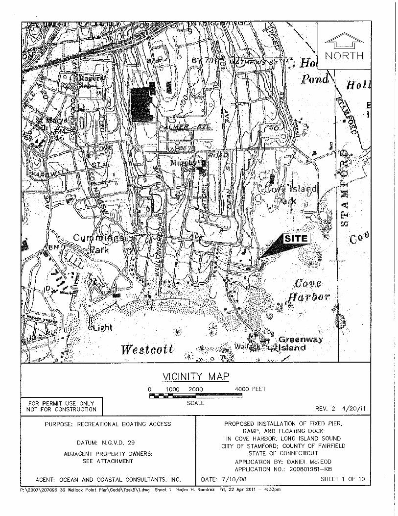
VICINITY MAP0 1000 2000 4000 FEET,’~,,~"" ,
SCALEREV. 2 4/2o/+1
PURPOSE: RECREATIONAL BOATING ACCESS
DATUM: N.G.V.D. 29
ADJACENT PROPERTY OWNERS:SEE ATTACHMENT
AGENT: OCEAN AND COASTAL CONSULTANTS, INC.
P:\2007\207098 38 Wallace Point Pier\Cadd\T~skS\1.dwg Sheet 1
PROPOSED INSTALLATION OF FIXED PIER,RAMP, AND FLOATING DOCK
IN COVE HARBOR, LONG ISLAND SOUNDCITY OF STAMFORD; COUNTY OF FAIRFIELD
STATE OF CONNECTICUTAPPLICATION BY: DANIEL McLEODAPPLICATION NO.: 200801981-KB
DATE: 7/10/08 SHEET 1 OF 10
Hajlrn H. Ramirez Fri, 22 Apt 2011 - 4:33pm

TAX ASSESSOR’S MAPNOT TO SCALEFOR PERMIT USE ONLY
NOT FOR CONSTRUCTION REV. 2 4/20/11
PURPOSE: RECREATIONAL BOATING ACCESS PROPOSED INSTALLATION OF FIXED PIER,RAMP, AND FLOATING DOCK
DATUM: N.G.V.D. 29IN COVE HARBOR, LONG ISLAND SOUND
CITY OF STAMFORD; COUNTY OF FAIRFIELDADJACENT PROPERTY OWNERS: STATE OF CONNECTICUT
SEE ATTACHMENT APPLICATION BY: DANIEL McLEODAPPLICATION NO.: 200801981-KB
AGENT: OCEAN AND COASTAL CONSULTANTS, INC. DATE: 7/10/08 SHEET 2 OF 10
P:\2007\207096 36 Wollock Point Pier\Codd\TeskS\2.dwg Sheet 2 Hejira Romirez Frl, 22 Apr 2011 - 4:35pm

PURPOSE: RECREATIONAL BOATING ACCESS
DATUM: N.G.V.D. 29
ADJACENT PROPERTY OWNERS:SEE ATTACHMENT
REV. 2
PROPOSED INSTALLATION OF FIXED PIER,RAMP, AND FLOATING DOCK
IN COVE HARBOR, LONG ISLAND SOUNDCITY OF STAMFORD; COUNTY OF FAIRFIELD
STATE OF CONNECTICUTAPPLICATION BY: DANIEL McLEODAPPLICATION NO.: 200801981-KB
4-/20/11
AGENT: OCEAN AND COASTAL CONSULTANTS, INC. DATE: 7/10/08 SHEET 3 OF 10
P:\2007\207096 36 Wolleck Point Pier\Cadd\ToskS\3.dwg Sheet 3 Hej3m H. Remirez Fri, 22 Apt 2011 - 4:52pm

,
// 75 LINEAR FEET OF/ / SEAWALL ON NOR~ PROPERTY
I
SEAWALL ON SOU~ PROPERTY
SEAWALL(120
COb
MARIE ANN C. BURNS2.69-~ ACRES
SEAWALL(110
30 LINEAR FEET OF FAILED SEAWALL
LIMIT OF ROCKS ON SHOREUNE
OF OUTCROPPED ROCK
FEET± OF SEAWALL UNDER COTTAGEFOUNDED OH LARGE ROCK OUTCROP
EL,+6.1’ ALONG FACE OP ROCK OUTCROP
BOULDERS AND
SPOT
(T~.),Xx
I
/
EXISTING PIER PLAN0 60 120 FT.
SCALE 1"=60’-0"
FOR PERMIT USE ONLYNOT FOR CONSTRUCTION REV. 2 4/20/11
PURPOSE: RECREATIONAL BOATING ACCESS
DATUM: N.G.V.D. 29
ADJACENT PROPERTY OWNERS:SEE ATTACHMENT
PROPOSED INSTALLATION OF FIXED PIER,RAMP, AND FLOATING DOCK
IN COVE HARBOR, LONG ISLAND SOUNDCITY OF STAMFORD; COUNTY OF FAIRFIELD
STATE OF CONNECTICUTAPPLICATION BY: DANIEL McLEODAPPLICATION NO.: 200801981-KB
AGENT: OCEAN AND COASTAL CONSULTANTS, INC. DATE: 7/10/08 SHEET 4 OF 10
P:\2007\207096 36 Woll~ck Point Pler\Codd\ToskS\4.dwg Sheet 4 Hejira H. RomRez Mon, 25 Apt 20il - lO:14om

TOP OF CONCRETE PIER EL.+8.0’:E
/~-BOULDERS ANDSTONES (TIP.)
MUDUNE
EXISTING SECTION A-A
CONCRETE SLAB
-CONCRETE SLAB
-EXPOSED FACE OF FAILED SEAWALL(STON E/~ ORTAR LOSS)
-UNDAMABED CONCRETE SLAB, BEYOND
-FACE OF EXISTING UNDAMAGEDSEAWALL, BEYOND
-APPROX. MUDLINE
EXISTING SECTION B-B
FOR PERMIT USE ONLY /NOT FOR CONSTRUCTION
0 5 10 FT.
SCALE ~6"=1’- 0"REV. 2 4/20/11
PURPOSE: RECREATIONAL BOA~NG ACCESS
DATUM: N.G.V.D. 29
ADJACENT PROPERTY OWNERS:SEE ATTACHMENT
AGENT: OCEAN AND COASTAL CONSULTANTS, INC.
PROPOSED INSTALLATION OF FIXED PIER,RAMP, AND FLOATING DOCK
IN COVE HARBOR, LONG ISLAND SOUNDCITY OF STAMFORD; COUNTY OF FAIRFIELD
STATE OF CONNECTICUTAPPLICATION BY: DANIEL McLEODAPPLICATION NO.: 200801981-KB
DATE: 7/10/08 SHEET 5 OF 10
P:\2007\207096 36 Welleck Point Pler\Cedd\T~skS\5.dwg Sheet. 5 Hajlm H. Ramirez Frl, 22 Apt 2011 -- 4:37pm

CONC.
EL.+ 8.0’:{:
/MORTAR LOSSIN SEAWALL (TYP,)
H,T.L, EL.+6.1’
t~UDLINEEL. VARIES
EXISTING SECTION C-C0 1 4 FT.
SCALE Y2"=1’-0"
FOR PERMIT USE ONLYNOT FOR CONSTRUCTION REV. 1 4/20/11
PURPOSE: RECREA~ONAL BOATING ACCESS
DATUM: N.G.V.D. 29
ADJACENT PROPERTY OWNERS:SEE ATTACHMENT
PROPOSED INSTALLATION OF FIXED PIER,RAMP," AND FLOATING DOCK
IN COVE HARBOR, LONG ISLAND SOUNDCITY OF STAMFORD; COUNTY OF FAIRFIELD
STATE OF CONNECTICUTAPPLICATION BY: DANIEL McLEODAPPLICATION NO.: 200801981-KB
AGENT: OCEAN AND COASTAL CONSULTANTS, INC. DATE; 7/10/08 SHEET 6 OF 10
P:\2007\207096 36 Vtallacl< Point Pier\Cedd\TeskS\5.dwg Sheet 6 Hejlm H, Remirez Fri. 22 Apt 2011 - 4:37pm

EXISTING SEAWALL TO BEMAINTAINED AND(120 L.F.:E)
EXISTING CONCRETESTAIRS TO
MARIE ANN C. BURNS2.6,9~ ACRES
EXISTING SEAWALL TOREMAIN (110
REMNANTS OF STONEGROIN TO REMAIN~
FOR PERMIT USE ONLY /NOT FOR CONSTRUCTION
/
CONCRETE PIER
J /
//
I
EL.÷4.4’ AND H.T.LEL+6.1’ ALON~G FACE OF SEAWALL
OF APPROXIMATELY30 LINE,~R FEETOF FAILED SEAWALL
ON SHOREUNE
TpE OF OUTCROPPED ROCK
EL.~’B.I’ ALONG FACE OF ROCK OUTCROP
-EXISTING 81’x11’ CONCRETE PIER TO BE RETAINED
~. xPROPOSED 4’x75’ PIER /
ii/ ,~NCHOR PILE (TYP.)
I / EXIST. BOULDERS SPOTt AND STONES (TYP.) ~LEVAllON (TYP.)
/ TIMBER FLOAT
!
PROPOSED PIER PLAN0 60 120 FT.
SCALE 1"=60’-0"
REV. 2 4/20/11
PURPOSE: RECREATIONAL BOA~NG ACCESS
DATUM: N.G.V.D. 29
ADJACENT PROPERTY OWNERS:SEE ATTACHMENT
AGENT: OCEAN AND COASTAL CONSULTANTS, INC.
PROPOSED INSTALLATION OF FIXED PIER,RAMP, AND FLOATING DOCK
IN COVE HARBOR, LONG ISLAND SOUNDCITY OF STAMFORD; COUNTY OF FAIRFIELD
STATE OF CONNECTICUTAPPLICATION BY: DANIEL McLEODAPPLICATION NO.: 200801981-KB
DATE: 7/10/08 SHEET 7 OF 10
P:\2007\207096 36 Wollack Point Pier\Codd\ToskS\7.dwg Sheet ¯ Hojim H. Romirez Mon. 25 Apt 2011 - lO:14em

REV. 3 4-/20/11
PURPOSE: RECREATIONAL BOATING ACCESS PROPOSED INSTALLATION OF FIXED PIER,RAMP, AND FLOATING DOCK
DATUM: N.G.V.D. 29IN COVE HARBOR, LONG ISLAND SOUND
CITY OF STAMFORD; COUNTY OF FAIRFIELDADJACENT PROPERTY OWNERS: STATE OF CONNECTICUT
SEE ATTACHMENT APPLICATION BY: DANIEL McLEODAPPLICATION NO.: 200801981-KB
AGENT: OCEAN AND COASTAL CONSULTANTS, INC. DATE: 7/10/08 SHEET 8 OF 10
P:\2007\207096 36 Walleck Point Pier\Cadd\ToskS\8.dwg Shee[ 8 Hojim H. Romlrez Fri, 22 Apt 2011

f EXISllNG CONCRETE SLAB
!EXISTING/PROPOSED IN-KIND, IN-PLACECONCRETE SLAB REBUILDING OF SEAWALL USING
EXISTING STONE AND RESTORATION
PROPOSED SECTION E-E
EXISI. CONC. SLA~7
POINTINGAND CHINKING OFEXIST. SEAWALL (TYP.)
- APPROX, EXIST.MUDLINE EL. VARIES
FOR PERMIT USE ONLYNOT FOR CONSTRUCTION
PROPOSED SECTION F-F0 1 4 FT.
SCALE YB"= 1’- 0"REV. 1 4/20/11
PURPOSE: RECREATIONAL BOATING ACCESS
DATUM: N,G.V.D. 29
ADJACENT PROPERTY OWNERS:SEE ATTACHMENT
PROPOSED INSTALLATION OF FIXED PIER,RAMP, AND FLOATING DOCK
IN COVE HARBOR, LONG ISLAND SOUNDCITY OF STAMFORD; COUNTY OF FAIRFIELD
STATE OF CONNECTICUTAPPLICATION BY: DANIEL McLEODAPPLICATION NO.: 200801981-KB
AGENT: OCEAN AND COASTAL CONSULTANTS, INC. DATE: 7/10/08 SHEET 9 OF 10
P:\BO07\207096 36 W(]lleck Point Pier\Cmdd\TeskS\9.d~’tg Sheet 9 H(]J~m H, Ramirez Fri, 22 Apr 2011 - 4:42pm

/ TOP OF PROPOSED| TIMBER DECKING
~ /EL.+8.7’~:
~=~~ / BOTTOM OF/" | PROPOSED STEEL
PROPOSED MC12 STEEL / / BEYONDSTRINGER (TYP.)
// M.H.W. EL.+ 4.4’
PROPOSED STEEL /ANGLE (TYP.)-
M,LW. EL.-2.9’
PROPOSED SECTION G-G0 1 4 FT.
FOR PERMIT USE ONLYNOT FOR CONSTRUCTION SCALE ~"=1’-0" REV. 3 4/20/11
PURPOSE: RECREATIONAL BOATING ACCESS PROPOSED INSTALLATION OF FIXED PIER,RAMP, AND FLOATING DOCK
IN COVE HARBOR, LONG ISLAND SOUNDDATUM: N.G.V,D. 29 CITY OF STAMFORD; COUNTY OF FAIRFIELD
ADJACENT PROPERTY OWNERS: STATE OF CONNECTICUTSEE ATTACHMENT APPLICATION BY: DANIEL McLEOD
APPLICATION NO.: 200801981-KB
AGENT: OCEAN AND COASTAL CONSULTANTS, INC. DATE: 7/10/08 SHEET 10 OF 10
9:\2007\207096 36 Wallack Point Pier\Cedd\TeskS\lO.dwg Sheet 10 Hejira H. Ramirez Fri, 22 Apt 2011 - 4:#2pro

OFFICE OF LONG ISLAND SOUND PROGRAMS
APPENDIX A
TO: Permit SectionDepartment of Energy and Environmental ProtectionOffice of Long Island Sound Programs79 Elm StreetHartford, CT 06106-5127
PERMITTEE: Daniel McLeod36 Wallacks DriveStamford, CT 06902
Permit No:
CONTRACTOR 1:
Address:
200801981-KB, Stamford, CT
Telephone #:
CONTRACTOR 2:
Address:
Telephone #:
CONTRACTOR 3:
Address:
Telephone #:
EXPECTED DATE OF COMMENCEMENT OF WORK:
EXPECTED DATE OF COMPLETION OF WORK:
PERMITTEE:(signature) (date)
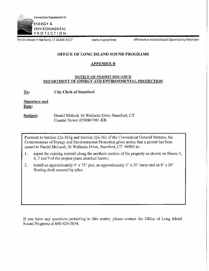
Connecticut Department of
"ENERGY &ENVIRONMENTALPROTECTION
79 Elm Street ¯ Hartford, CT 06~.06-5~_27 www.ct.gov/deep Affirmative Action/Equal Opportunity Employer
OFFICE OF LONG ISLAND SOUND PROGRAMS
APPENDIX B,
NOTICE OF PERMIT ISSUANCEDEPARTMENT OF ENERGY AND ENVIRONMENTAL PROTECTION
Signature andDate:
City Clerk of Stamford
Daniel Mcleod, 36 Wallacks Drive Stamford, CTCoastal Pert’nit #200801981-KB
Pursuant to Section 22a-363g and Section 22a-361 of the Connecticut General Statutes, theCommissioner of Energy and Environmental Protection gives notice that a permit has beenissued to Damiel McLeod, 36 Wallacks Drive, Stamford, CT 06902 to:
repair the existing seawall along the northern section of the propeloty as shown on Sheets 5,6, 7 and 9 of the project plans attached hereto;
install an approximately 4’ x 75’ pier, an approximately 3’ x 3l’ ramp and an 8’ x 20’floating dock secured by piles.
If you have any questions pel~alning to this matter, please contact the Office of Long IslandSound Programs at 860-424-3034.

PERMIT NOTICE
This Certifies that Authorization to performwork below the High Tide Line and/or withinTidal Wetlands of coastal, tidal, or navigable
waters of ConnecticutHas been issued to: Daniel McLeod
At this location: 3 6 Wallacks Drive Stamford, CT
To conduct the following: repair existing seawaIls and install a pier, ramp and float
Permit #: 200801981-KB Issued on: <Issue Date>
This Authorization expires on: <Expiration Date>
This Notice must be posted in a conspicuous place on the jobduring the entire project.
Department of Energy and Environmental ProtectionOffice of Long Island Sound Programs
79 Elm Street ¯ Hartford, CT 06106-5127Phone: (860) 424-3034 Fax: (860) 424-4054
www.ct.gov/deep

OFFICE OF LONG ISLAND SOUND PROGRAMS
APPENDIX A
TO: Permit SectionDepartment of Energy and Environmental ProtectionOffice of Long Island Sound Programs79 Elm StreetHartford, CT 06106-5127
PERMITTEE: Daniel MeLeod36 Wallacks DriveStamford, CT 06902
Permit No:
CONTRACTOR 1:
Address:
200801981-KB, Stamford, CT
Telephone #:
CONTRACTOR 2:
Address:
Telephone #:
CONTRACTOR 3:
Address:
Telephone #:
EXPECTED DATE OF COMMENCEMENT OF WORK:
EXPECTED DATE OF COMPLETION OF WORK:
PERMITTEE:(signature) (date)