Embed Size (px)
Citation preview
McClure Log House (Fallbrook Conservation Area)
Heritage Investigation Report
14513 – 27 Side Road Concession 9, Lot 28 Esquesing Township
Prepared by: T.Murison COPYRIGHTMay 12, 2008
McClure Log House – (Fallbrook Conservation Area) Heritage Investigation Report
Prepared by: T.Murison May 12, 2008
1.0 Introduction:
1.01 This Investigation was requested by The Friends of Fallbrook, local residents, former residents, and descendents of former residents who have strong ties with this farm, Silver Creek and the Municipality of Halton Hills.
1.02 The subject property, was referred to as the McClure –Vaughan House or the Beecham House in a previous report by Ian McGillivray Architect. The property is located at Concession 9, Part Lots 28,E ½ Esquesing Township. The Beecham family were recent tenants in the house, but indicated in public that they should not be connected with the name of the log building. The Vaughan Family who sold the property to the C.V.C. owned and lived on the property and constructed a stone house in the 1950’s which has been demolished. This Report will provide evidence (using a technique calledDendrochronology) to show that the original log house was constructed by McLure.
1.03 The property is owned by the Credit Valley Conservation Authority and is administered as a nature conservancy area, with trails, interpretive facilities, and several modern buildings in what was originally the barn yard of the farm. The house, bridge, creek and sites of other significant findings are believed to have all been part of the original land grant to the Canada Company, and first Lot division to McClure.
1.04 Parts of the former farm including the laminated wood–arch barn have been modified for use by school groups, and the public. Several new steel “modules”, single storey moveable buildings, have been placed on temporary foundations near the barn, for use as on site classrooms. A couple of cinderblock utility buildings are used for equipment and vehicles on site. Members of the Beecham family (who attended a meeting of the Friends of Fallbrook April ), explained that they resided in the house as tenants for only a few years and are surprised that the house has been referred to as the Beecham House since they did not build it and are not historically significant residents.
1.05 The log house was occupied until recently, but is now locked and hoarded pending review of an application to demolish the structure.
1.06 The purpose of this Report is to examine the house, obtain further information about it’s age, historic significance and heritage value. As sometimes happens, when examining early buildings, the history of house and land may have completely unexpected elements and significance. Features of the house, and archaeological remains (native – late woodland) on the property indicate that other historically significant structures including the bridge, a sawmill, grist mill, dam and a quarry existed on the site. It would also appear that McClure had experience as a miller.
2

1.07 Evidence for these structures will be discussed to show that the house was constructed in a special way and for a very specific purpose, which has been completely lost from the historic record, and the oral traditions of the families in the vicinity of the house. This suggests that the mills and dam disappeared early in the history of the site.. The author and Friends of Fallbrook also noticed and confirmed the presence of an important Late Woodland archaeological site close to the house. While this native village has completely disappeared, it suggests that there is a very long and significant pre-history to the site which also deserves to be protected and interpreted.
1.08 The Friends of Fallbrook obtained access to the building, through the generous cooperation of the owner (C.V.C.A.). The Credit Valley Conservation Authority have suggested that they will receive and consider a preservation proposal from the Friends of Fallbrook in June, of this year. The proposal (or business plan) will make recommendations as to how this may be done.
1.09 The Site was visited on April 26, 2008. Weather was overcast, 15 degrees. C. Photographs were taken of the exterior and interior of the house as the building was being examined. Brian Kristy, Property Superintendent, of the C.V.C. opened the house, and explained some of the recent maintenance history of the house.
1.10 The house was examined room by room. The author provided a commentary about the features and construction techniques as the examination progressed. In the attic of the original log house the author found part of the original exterior wall exposed and accessible in the crawlspace. Construction details were noted and photographed, and a sample of the top log on the east gable was sawn from the shoulder of a notch at the south end of this log, when it was determined that it was original to the building and in excellent condition, and retained bark on the outside which would could confirm the specific year that the tree was felled. See Dendrochronology (page 18) for anexplanation of this technique and the date of the house.
3
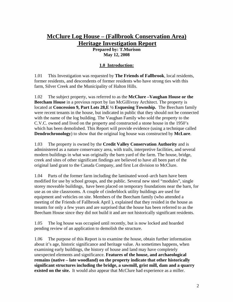
South Elevation of House (03/08) Oldest part of house, log cabin, at the left, with frame addition visible, (door at center). Shed roof addition at rear (right side) is over masonry wall which retains hillside behind north side of house. The stone walls in the foreground were constructed in the twentieth century to elevate the laneway from the field. 1.11 Plywood hoarding was removed from the door to the porch at the east end of the building, the door on the south side and the adjoining window to what was the living room of the house.
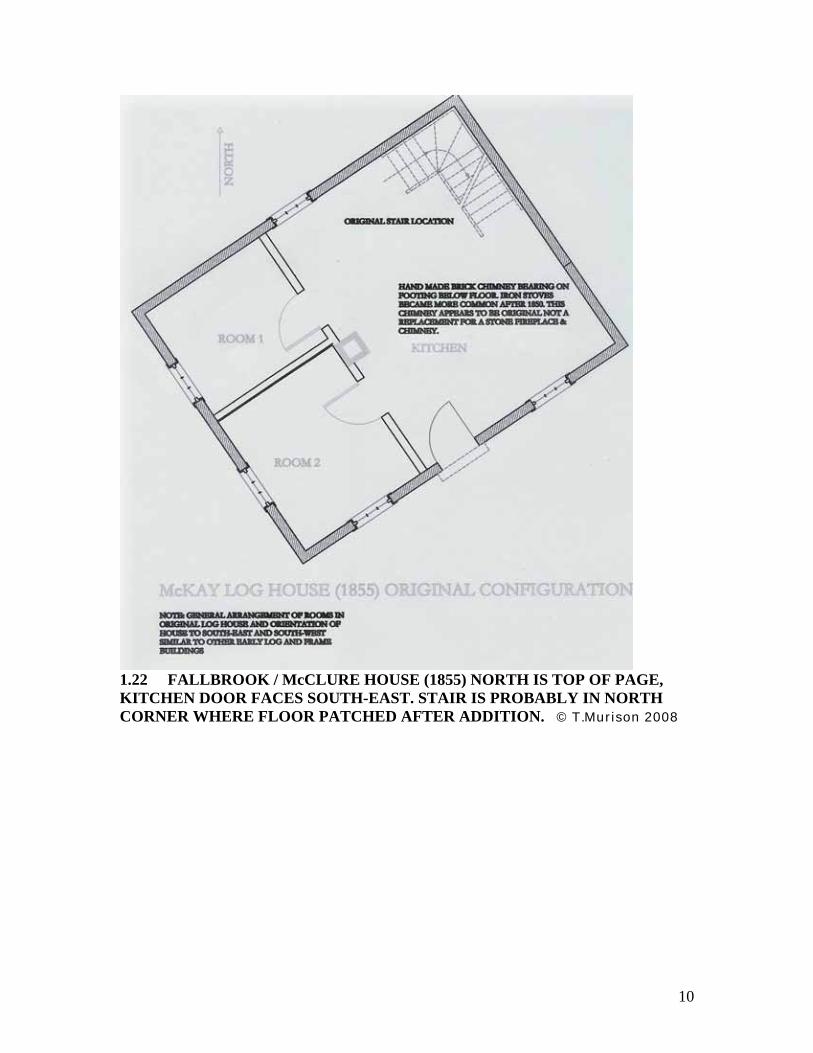
1.12 The addition on the north side of the building was entered first. These two rooms were constructed with a rubble stone wall laid up to 7 feet above grade, excavated and backfilled with up to 5 feet of soil on the exterior where the hillside slopes down to this wall. A shed roof over this space is attached to the main roof of the house. The larger room (with the outside entry) was used as a porch and utility space. The furnace and electrical panel were installed here. A window is placed high on the east wall in the frame construction above the masonry. The smaller room measuring approximately 8’ x 10’ has a single door on center of the common wall with the utility room, and a single window (boarded) facing west. The interior finish is paint over whitewash. Two square holes indicate that wood scantlings were used to support a shelf, probably for preserves and foodstuffs in this room (which would remain cool year round).
1.13 The storey –and-a-half house was constructed in two parts, but sided with a coved shiplap. The larger structure on the west side, was built as a log house, measuring approximately 20’ x 28’ (a very typical size due to the weight of logs, and convenient spans that could be achieved with timber joists), A doorway from the utility room to the Kitchen (addition) opens beside the stairs to the second floor.
4

© T.Murison 20081.14 View west inside the earth embanked, utility room Blue door, left into kitchen. The stone wall (right side) is almost completely below grade. This stone addition may have been a very early addition to the house, constructed to deal with the chronic damp from snow and leaves against the north wall of the log house. In fact, the lower log course and exterior siding (just beyond the root cellar) was replaced by the C.V.C. approximately seven years ago. The slope of the hillside towards the house and the damp conditions on this north west corner have probably been of concern since the house was first built.
© T.Murison 2008
5
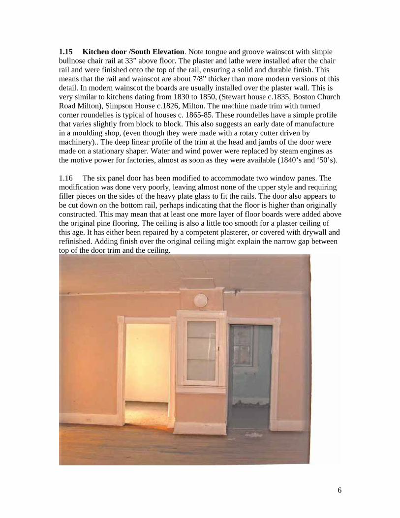
1.15 Kitchen door /South Elevation. Note tongue and groove wainscot with simple bullnose chair rail at 33” above floor. The plaster and lathe were installed after the chair rail and were finished onto the top of the rail, ensuring a solid and durable finish. This means that the rail and wainscot are about 7/8” thicker than more modern versions of this detail. In modern wainscot the boards are usually installed over the plaster wall. This is very similar to kitchens dating from 1830 to 1850, (Stewart house c.1835, Boston Church Road Milton), Simpson House c.1826, Milton. The machine made trim with turned corner roundelles is typical of houses c. 1865-85. These roundelles have a simple profile that varies slightly from block to block. This also suggests an early date of manufacture in a moulding shop, (even though they were made with a rotary cutter driven by machinery).. The deep linear profile of the trim at the head and jambs of the door were made on a stationary shaper. Water and wind power were replaced by steam engines as the motive power for factories, almost as soon as they were available (1840’s and ‘50’s).
1.16 The six panel door has been modified to accommodate two window panes. The modification was done very poorly, leaving almost none of the upper style and requiring filler pieces on the sides of the heavy plate glass to fit the rails. The door also appears to be cut down on the bottom rail, perhaps indicating that the floor is higher than originally constructed. This may mean that at least one more layer of floor boards were added above the original pine flooring. The ceiling is also a little too smooth for a plaster ceiling of this age. It has either been repaired by a competent plasterer, or covered with drywall and refinished. Adding finish over the original ceiling might explain the narrow gap between top of the door trim and the ceiling.
6
Interior of log house looking west. © T.Murison 2008
1.17 View West through the main room (formerly kitchen) into two small bedrooms on the south-west elevation. Note the masonry chimney stack hidden behind cupboard. The door in the cupboard has a single piece of glass typical of mid twentieth century so is probably a reproduction cabinet. The moulding around the frame appears to be similar to 1850’s trim, but if it were an original construction, one would expect to find a beaded edge to the door opening, and a chamfered joint where the beads joined at the top and sides of this opening. The wood stool under the door is similar to original details. This cupboard appears to be a modern intervention in the design of the room, probably intended to cover the unused masonry flue, and provide a little storage space.
1.18 Note also, the “pie plate” cover over the thimble into the masonry flue, where the stove pipe was inserted into the flue. This masonry may be original or may be a later addition to the house. The typical floor plan (large room with two small “slip” rooms on one side) is consistent with early floor plans like the Peter Mattthews House, Brougham (now part of the Brougham Central Hotel, under restoration at Pickering Museum village, dated 1821.) The entry door of these log houses was typically near the center of the long wall, (just to the left of this image) with a partition dividing the space into three rooms, 60% of the floor plan being the larger room which served as kitchen/living room/etc., and the other two small rooms being used as the bedroom for the parents, and a second bedroom, typically for a baby or the youngest children. Other children slept upstairs in the attic typically. A fireplace was often built on the center of this partition where the masonry flue is. At an early date this fireplace was a massive structure to allow a pot crane to carry the cooking pots over the fire which burned almost continuously. See illustration of a typical floor plan for Peter Matthews House, which measured 20’ x 28’..
7

© T.Murison 2008 1.19 Peter Matthews House, Pickering Museum Village, Greenwood, Ont. The exterior fireplace on the north gable wall at P. Matthews house is unusual. Most were central to the house. However, the floor plan is very similar (mirror plan) to the subject property, & suggests that the original stair location to the attic was in the principle room, before the addition was made to the east side of the house. See next (3) illustrations.
8

1.20 PETER MATTHEWS HOUSE 1822: ORIENTATION (NORTH AT TOP) KITCHEN DOOR FACES SOUTH-WEST © T.Murison 2008
1.21 Even though this is a vertical plank frame building and not a log structure, the general dimensions and layout are similar to the subject building, with careful attention to orientation of the windows. This suggests that obtaining natural light was paramount in the builders mind and that the wall which faced into the prevailing winds in winter, was most often left blank at the ground floor. . The single window on the north-east elevation was changed to a door probably before 1845. The fireplace and stairs in the north wall was also removed as per notes. The cupboards stair was very steep and occupied as small a space as possible. It was usually enclosed with a board partition and batten door at the bottom. Closing this door would keep the ground floor rooms warmer in winter.
9
1.22 FALLBROOK / McCLURE HOUSE (1855) NORTH IS TOP OF PAGE, KITCHEN DOOR FACES SOUTH-EAST. STAIR IS PROBABLY IN NORTH CORNER WHERE FLOOR PATCHED AFTER ADDITION. © T.Murison 2008
10
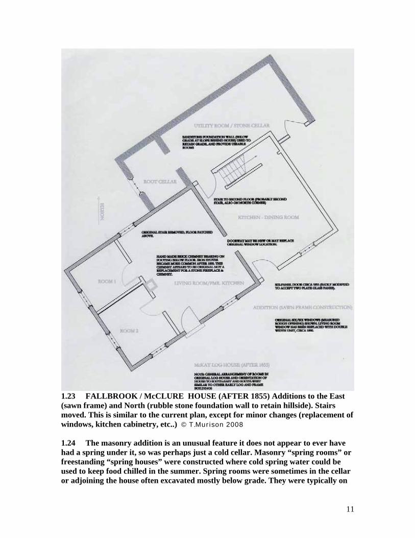
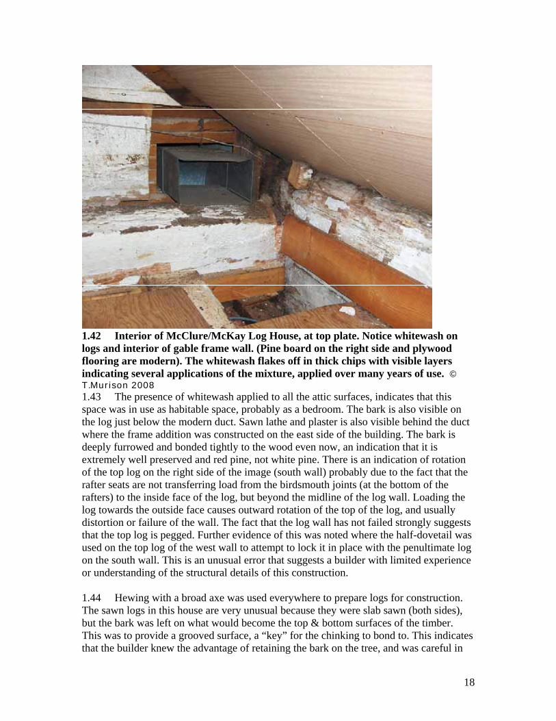
1.23 FALLBROOK / McCLURE HOUSE (AFTER 1855) Additions to the East (sawn frame) and North (rubble stone foundation wall to retain hillside). Stairs moved. This is similar to the current plan, except for minor changes (replacement of windows, kitchen cabinetry, etc..) © T.Murison 2008
1.24 The masonry addition is an unusual feature it does not appear to ever have had a spring under it, so was perhaps just a cold cellar. Masonry “spring rooms” or freestanding “spring houses” were constructed where cold spring water could be used to keep food chilled in the summer. Spring rooms were sometimes in the cellar or adjoining the house often excavated mostly below grade. They were typically on
11

the north side of the building to minimize heat gain. The Hager House on the north-west corner of Dundas and Bronte Road in Palermo has a masonry spring room adjoining the oldest timber frame portion of the house (c. 1808). This room was excavated four feet into the ground with thick stone walls and windows for ventilation. It was in shade for almost the entire day even in summer.
Hager House, two storey circa 1830, one storey circa 1808. Spring room, after 1808. © T.Murison 20081.25 The small cold room in the masonry addition has indications of shelving for preserves which were probably stored in crocks, and root crops. The oral history of the Fallbrook neighbours, suggests that ice was cut from the creek by farmers who lived near by. It is possible that ice was placed in sawdust in this room in the spring, so that food could be kept cold in the summer, but no sign of a drain was noticed either in the more recently installed concrete floor or in the masonry wall. The room may have relied on outside ventilation and northern exposure to keep food cool (55 to 75 degrees F. in the summer). This would be less efficient than a spring room which could keep food at (38 to 45 degrees F.) with sufficient flow of cold spring water.
1.26 The high walls of this addition, which were constructed partly to hold the hillside back, are an unusual feature since log houses were rarely built on a hillside like this, when level ground could be found close by. Orientation of long walls facing south-east and north-west, and cupboard stair on the north corner, is similar to the Peter Matthews House (1821) (Greenwood), Collins vertical plank house (1830)(Rockton) and several
12

others investigated by the author. Floor plans were fairly standardized based on environmental considerations, as follow:
1. Few windows and openings on the north-west or north-east walls, reduced heat loss in winter. 2. Cupboard stairs in corner of kitchen, provided security for upstairs sleeping rooms, and reduced drafts down the stairs to the main floor. 3. Windows on the south-east and south-west elevation provide morning and
afternoon light to the house to minimize the need for artificial illumination (candles) for morning and evening tasks. The fireplace was virtually the only source of light in the evening, due to the cost of candles. (Interiors were also whitewashed to increase albedo of the interior surfaces.
4. Water was drawn from the creeks, often for many years. When wells were eventually dug, they were place close to the kitchen door to minimize distance to haul water in cold weather. (One must keep in mind how many thousands of buckets of water a woman would have to draw for normal household chores in a year, especially as the family grew in size)
5. Second floor used for sleeping with either one or two rooms accessed from steep stairs or in earliest examples, a ladder.
1.27 The McLure House follows the typical early floor plan (1820’s & 1830’s).for dimensions, proportions and building plan (see illustration 120 above.). While the house was constructed after 1855, the size of the floor pan was still controlled by the largest logs which could be lifted conveniently by a small crew, and the builder’s experience with, other log buildings. Things like high child mortality rates and a series of harsh winters also played a role in how people chose to orient and construct their houses.
1.28 The eaves of the house are slightly lower than what was usual, 14 feet, indicating that maximizing habitable space at the second floor was less important than economy of construction. The attic did not have floor boards, knee walls and ceilings until the 1950’s (Wayne Gates, former resident).The few boards found in the attic floor in the 1940’s were not even nailed to the joists, suggesting that it was not used as a sleeping loft for children in a large family, as was typical. The addition to the east was framed in sawn lumber not logs. Photo from attic corner shows portion of top plate at east gable rafter.
13

1.29 Timber top plate with portion of sawn top plate from adjoining addition visible under paneling (just below end of 1” sheathing that has been sawn off. Note also, the notch in the 8” log forming the top plate to support the rafters, and the sawn 3” x 4” piece that may have been used as a girt or tie beam for the log gable. The rafter tails were birdsmouthed in the typical way, but were stepped more than 5” into the log requiring a deep notch. It was more typical for the birdsmouth to be seated on a 1” notch chopped into the inner face of the log with a hatchet or broad axe. This method of roof construction and shallow pitch (approximately 5/12 are typical of the 1830-50 period. The sawn off 3” x 4” pine girt is a novelty however. The purpose of this piece is probably as a tie between the top plates across the house. Removal of the ceiling would be necessary to see if it has a dovetail connection to the timber, but it seemed to be installed tightly into the plate.
1.30 The construction of the roof ridge was concealed by ceilings and could not be examined. The collar ties across the attic ceiling, plaster finish, and panel board in the eaves suggest that the attic was finished some time after the house was constructed, perhaps even in the second half of the twentieth century. The original roof was often left unfinished with the underside of the sheathing, (including shingle nails), visible from below. The rafters are probably butted together at the ridge (without a ridge board), with between 2 and 5 nails driven through the joint. This was adequate for roofs of this type provided the rafter soles were restrained from moving laterally.
14

1.31 Siding on the west gable has been opened up to allow access to the wall behind. The top plate is exposed at the south-west corner. The top log of the south wall appears to be squared two faces but left round at the end. The next log down, forming the top log on the gable wall has a half-dovetail to tie the two long walls together. The half dovetail joint will slide up over the adjoining log unless it is loaded with weight from above, or pegged. Since the weight of the single top log is insufficient to ensure the connection, one would expect to see a single trenail at least 1” diameter, driven through this joint. It is not known whether other logs further down the wall have a similar locking notch. On the north west corner, damaged siding allowed one log end to be seen. It was squared both ways, and does not seem to have been cut to lock in place.
1.33 Four log corner joints (The Craft of Log Building, Hermann Phleps 1877 – 1964)
1.34 These details were among the simplest used in European log buildings. #31 Half Lap, (with peg) and #32 Stepped lap (with peg) are like most early Ontario log houses. These joints were most often left unpegged, requiring the weight of logs above to provide sufficient friction to keep the joint tight. Sometimes pegs were used only in the top one or two notches where insufficient weight above left the logs vulnerable to displacement. #33 Dovetail, is uncommon in Ontario, but represents high quality workmanship which keeps the corners tightly connected. #34 Stepped lap with splines, may not have been used in traditional houses in Ontario, but the author has re-constructed a log building with this detail in order to prevent the lateral displacement (away from the corners) which causes the chinking to break and fail. Tight joints between logs at each course was a military specification in blockhouses, in order to prevent musket and cannon fire from penetrating the joints. Some blockhouses are also reported to have used a stepped horizontal joint (equivalent to a ship lap), instead of splines, to achieve a safer and more air tight joint between the timbers.
1.35 The half-dovetail joint used for the top gable log in the subject house, may indicate that the builder had some knowledge of the problem of spreading at the corners, but had not pegged the lap joints at the corners as they were being constructed. Instead, he decided to try to improve the top log joint, with a half dovetail, without understanding its weakness in this configuration.
15
1.36 The joints that could be seen between the logs were covered with a strong lime mortar, well mixed and bonded to the bark on both logs, (above and below) the joint. Squaring the two vertical faces, but leaving bark on the horizontal edges of the log was common in Ontario houses, since the rough bark (especially in this case since red pine (Pinus resinosa) may have been used for the logs as well as rafters) was rough and provided a good substrate for the chinking to bond to. Behind the lime chinking some clay was found, suggesting that the core of the wall may have been chinked with a clay/straw, or clay/straw/dung mixture. Cow dung was a common additive since it fermented in the chinking providing air bubbles that gave the chinking more flexibility and protection from frost, (an important consideration in the dead of winter, when chinking sometimes feel out of shrinking logs). Examination of clay chinking at the Puterbaugh log house, Pickering Twp. Showed that meadow grass (not rye, oat or wheat straw) was cut and chopped into short lengths to reinforce the mixture). This may be because meadow grass was more readily available, and because the first crops of grain where either insufficient or not yet harvested when the chinking was being installed in the walls. The author has found that two inch lengths of dry grass stalks work very well, when added in sufficient quantity in the hydrated clay mix. The resulting chinking can be built up to fill joints up to 4 inches in height. Above 4 inches, the builders usually inserted split cedar rails which were triangular in section, to reduce the chinking required.
1.37 The lime mortar observed in the attic may be a later “finish” applied over the logs & clay chinking as a way to give a more permanent and durable surface to the wall.
1.38 While the interior of the wall could not be examined (except in the knee wall space in the attic) it was found to have multiple layers of whitewash applied to the inside face of the logs. White wash is essentially a slurry of slaked lime and water made to the consistency of thick cream. Sometimes a little sand was added, but because whitewash was painted on with a stiff brush, it had to be relatively fluid. White wash performed several functions in the log house:
Sealed small cracks and knots Provided a much brighter interior which enhanced the amount of light coming
from the windows. Covered up dirt and particularly smoke from the constantly burning wood fire in the hearth. Provided a little fire protection for the logs. Sterilized the logs with a surface that discouraged insects, mould and the yet unknown germs.
1.39 Whitewash was used almost universally on the interiors of log houses, and was applied over the chinked joints as well. It makes a particularly nice finish on the clay chinking, allowing the texture of the grass straw to show through the finish. The entire house was probably whitewashed inside when completed.. Sawn lathe was used for the plaster finishes in the frame addition. If it can be determined that this was western red cedar lathe, a post-Transcontinental railroad date (1886) may be assumed for this work.
16

Interior of another example, the reconstructed Puterbaugh Log House, whitewash on walls & ceiling. © T.Murison 20081.40 This reconstruction of a one-room schoolhouse placed the fireplace hearth on the north wall. While this would create a larger room needed in a school, in most houses the hearth would have been situated directly in front of the doorway creating one or two small rooms behind it. The brightness of the room, even in mid-day with the door open, demonstrates how important a nearly white wall finish was in these early houses. If one compares the albedo (reflectance) of the whitewashed logs verses raw logs, the difference is approximately 85% reflectance vs. 40% reflectance, meaning that the whitewashed room was more than twice as bright to work in. This made everday tasks simpler and must have contributed to a greater sense of well being for the occupants on dark and overcast days. This raw pine floor is what one would expect with a newly constructed log house. (For museum use, with many more visitors than the house would ever receive in normal use, an oil floor finish was applied to increase durability).
1.41 We do not know whether the house had a central fireplace/cooking hearth in the log house, but it would be expected. Evidence of a foundation for the stone fireplace may still exist under the floor of the living room, (in the crawlspace). A painted brick chimney was observed upstairs in the house but may be a later replacement of a stone fireplace, since good, easily accessible building stone was available very close to the house. The foundations may also have been constructed with stone.
17
1.42 Interior of McClure/McKay Log House, at top plate. Notice whitewash on logs and interior of gable frame wall. (Pine board on the right side and plywood flooring are modern). The whitewash flakes off in thick chips with visible layers indicating several applications of the mixture, applied over many years of use. © T.Murison 20081.43 The presence of whitewash applied to all the attic surfaces, indicates that this space was in use as habitable space, probably as a bedroom. The bark is also visible on the log just below the modern duct. Sawn lathe and plaster is also visible behind the duct where the frame addition was constructed on the east side of the building. The bark is deeply furrowed and bonded tightly to the wood even now, an indication that it is extremely well preserved and red pine, not white pine. There is an indication of rotation of the top log on the right side of the image (south wall) probably due to the fact that the rafter seats are not transferring load from the birdsmouth joints (at the bottom of the rafters) to the inside face of the log, but beyond the midline of the log wall. Loading the log towards the outside face causes outward rotation of the top of the log, and usually distortion or failure of the wall. The fact that the log wall has not failed strongly suggests that the top log is pegged. Further evidence of this was noted where the half-dovetail was used on the top log of the west wall to attempt to lock it in place with the penultimate log on the south wall. This is an unusual error that suggests a builder with limited experience or understanding of the structural details of this construction.
1.44 Hewing with a broad axe was used everywhere to prepare logs for construction. The sawn logs in this house are very unusual because they were slab sawn (both sides), but the bark was left on what would become the top & bottom surfaces of the timber. This was to provide a grooved surface, a “key” for the chinking to bond to. This indicates that the builder knew the advantage of retaining the bark on the tree, and was careful in
18
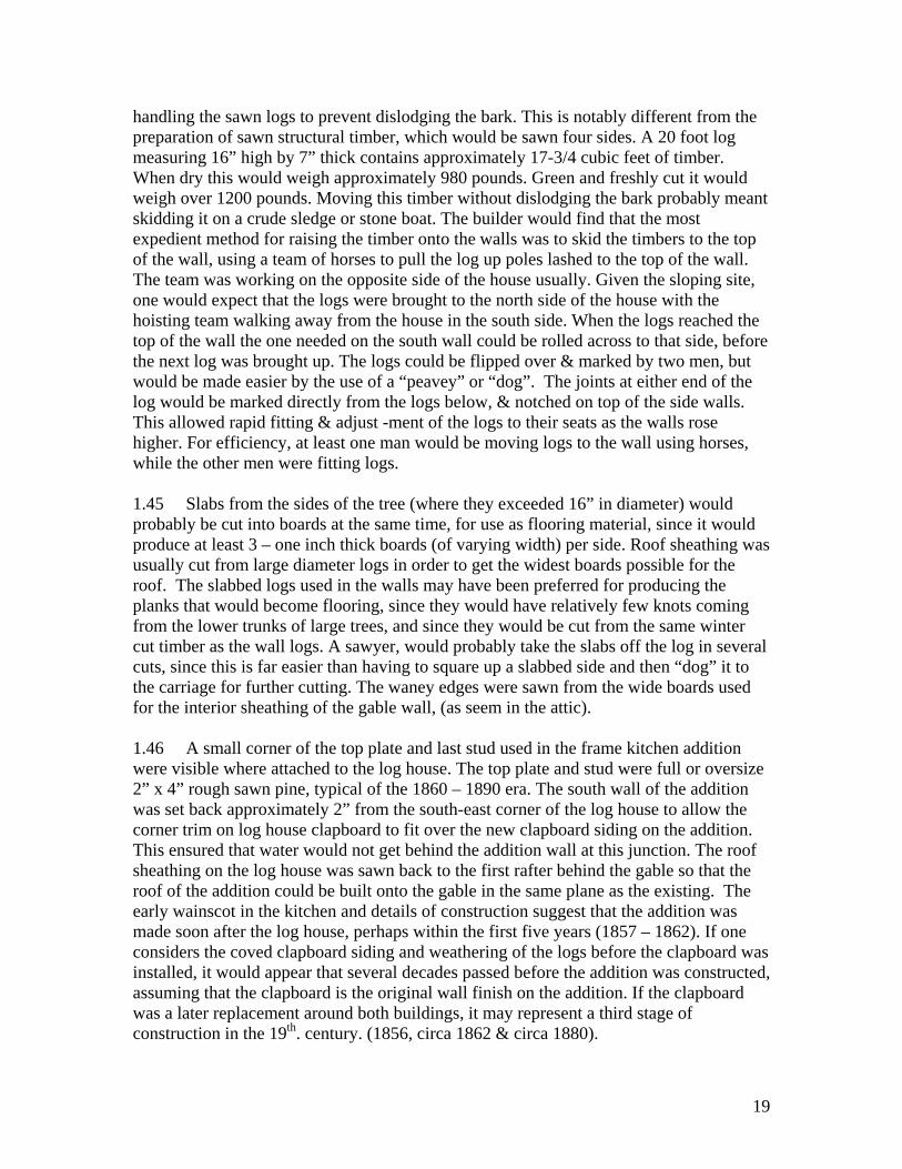
handling the sawn logs to prevent dislodging the bark. This is notably different from the preparation of sawn structural timber, which would be sawn four sides. A 20 foot log measuring 16” high by 7” thick contains approximately 17-3/4 cubic feet of timber. When dry this would weigh approximately 980 pounds. Green and freshly cut it would weigh over 1200 pounds. Moving this timber without dislodging the bark probably meant skidding it on a crude sledge or stone boat. The builder would find that the most expedient method for raising the timber onto the walls was to skid the timbers to the top of the wall, using a team of horses to pull the log up poles lashed to the top of the wall. The team was working on the opposite side of the house usually. Given the sloping site, one would expect that the logs were brought to the north side of the house with the hoisting team walking away from the house in the south side. When the logs reached the top of the wall the one needed on the south wall could be rolled across to that side, before the next log was brought up. The logs could be flipped over & marked by two men, but would be made easier by the use of a “peavey” or “dog”. The joints at either end of the log would be marked directly from the logs below, & notched on top of the side walls. This allowed rapid fitting & adjust -ment of the logs to their seats as the walls rose higher. For efficiency, at least one man would be moving logs to the wall using horses, while the other men were fitting logs.
1.45 Slabs from the sides of the tree (where they exceeded 16” in diameter) would probably be cut into boards at the same time, for use as flooring material, since it would produce at least 3 – one inch thick boards (of varying width) per side. Roof sheathing was usually cut from large diameter logs in order to get the widest boards possible for the roof. The slabbed logs used in the walls may have been preferred for producing the planks that would become flooring, since they would have relatively few knots coming from the lower trunks of large trees, and since they would be cut from the same winter cut timber as the wall logs. A sawyer, would probably take the slabs off the log in several cuts, since this is far easier than having to square up a slabbed side and then “dog” it to the carriage for further cutting. The waney edges were sawn from the wide boards used for the interior sheathing of the gable wall, (as seem in the attic).
1.46 A small corner of the top plate and last stud used in the frame kitchen addition were visible where attached to the log house. The top plate and stud were full or oversize 2” x 4” rough sawn pine, typical of the 1860 – 1890 era. The south wall of the addition was set back approximately 2” from the south-east corner of the log house to allow the corner trim on log house clapboard to fit over the new clapboard siding on the addition. This ensured that water would not get behind the addition wall at this junction. The roof sheathing on the log house was sawn back to the first rafter behind the gable so that the roof of the addition could be built onto the gable in the same plane as the existing. The early wainscot in the kitchen and details of construction suggest that the addition was made soon after the log house, perhaps within the first five years (1857 – 1862). If one considers the coved clapboard siding and weathering of the logs before the clapboard was installed, it would appear that several decades passed before the addition was constructed, assuming that the clapboard is the original wall finish on the addition. If the clapboard was a later replacement around both buildings, it may represent a third stage of construction in the 19th. century. (1856, circa 1862 & circa 1880).
19

2.0 Dendrochronology:- The tree tells the story
2.01 Dendrochronology is a dating technique which uses the sequence of tree rings in a sample with a known date to provide a comparative date for a tree or log sample which has an unknown date of felling. This is one of the most accurate dating tools used by archaeologists, and had been used to re-calibrate carbon 14 dating sequences in the south-west U.S., Egypt, the middle east, and elsewhere. In Egypt, sequences of carbon 14 dates for ancient artifacts were discovered to be inaccurate by nearly 200 year (over a timescale of 4000 years), when dendrochronology was applied to the samples. Dendrochronology is the most accurate method for dating historic objects made of wood.
2.02 The sawn sample was taken from the end notch of the top gable log at south-east corner, just below the roof. (Photo 1.29). The sample was sawn with a razor saw and removed a cross section of the log (including bark) tangential to its axis. A total of 59 annual growth rings were included in the sample. The sample was found to be free from insect infestation, indicating that it was probably winter cut wood, that was prepared and used in the construction of the cabin early in the spring. The sample was sanded and prepared for photography, enhanced and enlarged over 525%. This allows a higher resolution for the measurement of data, and accuracy in the graph. The data was plotted against a data set (Waldies Tie Beam 1870) which is cross referenced to historical documents and other samples. The sample was plotted for every year between 1816 and 1867. The best match was 1855, see photo and chart.
2.03 Sample 01 – Fallbrook– McClureHouse, Top Plate © T.Murison 2008
20
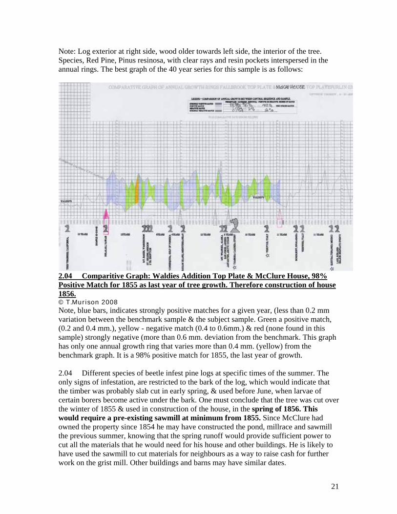
Note: Log exterior at right side, wood older towards left side, the interior of the tree. Species, Red Pine, Pinus resinosa, with clear rays and resin pockets interspersed in the annual rings. The best graph of the 40 year series for this sample is as follows:
2.04 Comparitive Graph: Waldies Addition Top Plate & McClure House, 98% Positive Match for 1855 as last year of tree growth. Therefore construction of house 1856.© T.Murison 2008Note, blue bars, indicates strongly positive matches for a given year, (less than 0.2 mm variation between the benchmark sample & the subject sample. Green a positive match, (0.2 and 0.4 mm.), yellow - negative match (0.4 to 0.6mm.) & red (none found in this sample) strongly negative (more than 0.6 mm. deviation from the benchmark. This graph has only one annual growth ring that varies more than 0.4 mm. (yellow) from the benchmark graph. It is a 98% positive match for 1855, the last year of growth.
2.04 Different species of beetle infest pine logs at specific times of the summer. The only signs of infestation, are restricted to the bark of the log, which would indicate that the timber was probably slab cut in early spring, & used before June, when larvae of certain borers become active under the bark. One must conclude that the tree was cut over the winter of 1855 & used in construction of the house, in the spring of 1856. This would require a pre-existing sawmill at minimum from 1855. Since McClure had owned the property since 1854 he may have constructed the pond, millrace and sawmill the previous summer, knowing that the spring runoff would provide sufficient power to cut all the materials that he would need for his house and other buildings. He is likely to have used the sawmill to cut materials for neighbours as a way to raise cash for further work on the grist mill. Other buildings and barns may have similar dates.
21

3.0 Re-examination of the Ownership Chain::
3.01 The following review of the ownership of the property was compiled by Ian McGillivray, Architect. The assignment of a construction date (1869) to the log house in that report was made based on archival research only, without the benefit of a firm construction date (1856) from a sample of wood from the house. The interpretation of the historical records is made more accurate by the use of the timber date, since it can exclude other owners (both earlier and later) when one knows the precise year of construction, as the following excerpt from Mr. McGillvray’s Report will show:
3.02 “ Ownership Summary:1841-1854 Canada Company 1855-1869 William McClure: (Owner when the top plate was cut.& used) 1869-1871 Joseph Smith & John McDonald (sic) 1871-1872 John McDonald (sic) 1872-1873 Charles Symon and David Allan March 1873 David Allan takes out $5925 mortgage with Ontario Bank March 1873 There was an action between John MacDonald (plaintiff) and Charles Symon and David Allan (defendants) involving this land and land in Concession 8 to a total of 26 ½ acres. April 1873 David Allan takes out another mortgage with John Allan. Chas. Symon’s interest assigned to Wm. Allan. 1874 David Allans interest given in “quit claim” to Ontario Bank. 1874-1877 William Allan & Ontario Bank March 1877 Donald McKay to Samuel Irwin Mtg. $306. Mar. 1877 - 1877 Samuel Irwin Sold immediately Mar. 1877 – 1918 Donald McKay Grant – Part of E ½ & other lands. (probable builder of additions to the east & north side of the house) April 1877 Samuel Irwin to Thomas Carberry Mtg. $250
1877 Donald McKay to Henry Plomeux (?) Mtg. $100. This is the last reference to 21 ¾ acres. 1895 Donald McKay seems to have acquired another 6 acres
“Part of Esterly ½ and other land”. 1918 – 1943 Alexander McKay Grant – Part of E ½ W. of traveled road & other lands. 26 acres. (Other transfers) Credit Valley Conservation 1973 Grant. (Current owner) “
It is clear that William McClure’s long tenure on the site coincides with the 1855 date for the top log sample, making him the builder of the log house, and by association the sawmill, and grist mill. The loss of 95% of the value of the property supports the idea that the mill & dam were lost just before McKay bought it in 1877.
\
22

4.0 On the Mill trail:
4.01 The investigation of the house was intended to determine the age of the the structure, and possibly the provenance of the original builder. As with many historic projects, unexpected connections with the history of the house often come into focus.When sawn logs were seen in the west wall of the house, it immediately raised questions as to why logs in this house should not be hewn as was almost, universal. Several possibilities came to mind. First, that the logs where actually hewn and then planed, Secondly that the logs were sawn by two men using a pit saw, or thirdly that the logs were sawn at a mill.
4.02 The idea that the logs were all hewn and then planed was rejected because it would take a huge amount of time to do this, and it simply wouldn’t be considered worthwhile on any log structure. Even where flooring was hand planed, the builder would often opt to plane only to the top side, and leave the bottom rough, even if this meant that the planks were of varying thickness. Planing a log smooth on each side could double the preparation time from 1-1/2 - 20 foot logs per day, to two days.
4.03 The second option would seem most logical, since rip and crosscut saws were common tools for most settlers. The problem with ripping logs was that it would usually have to be done with a pit. One man working above on a pair of planks pulling the saw up on the upstroke, and the other man working under the log, in a pit, under all the sawdust and debris from the cutting. Needless to say, working below was not a popular choice, and was usually forced on the helper by the boss. The high volume of water and steep gradient of the creek would have immediately suggested to settlers, that a mill would work well in this location.
4.04 Wood fibres in the weathered surface of the house wall are fuzzy and have lifted from the sawn surface indicating that they were exposed to the weather for at least ten years before the siding was installed over the logs. The smooth surfaces may have reduced checking and made for a nicer surface on the inside of the wall. Annual maintenance of the chinking to prevent air leaks was a laborious chore, and drove most owners to cover the walls with siding, eventually.
4.05 The author decided to check for signs that a sawmill had been constructed nearby. The head race was easily identified while snow was on the ground. When one looks north (from the east end of the bridge) the millrace looks like a boulder strewn U-shaped ditch. It runs up over the contours of a small ridge to a spot where the creek is 4 feet lower than the threshold of the headrace. Why diversion of the creek for the sluice to the gristmill was not done downstream near the bridge (where the banks are very close), was not immediately apparent. This would have been a shorter route if the grist mill was intended to be the first and only mill on the site. Building a dam upstream near what probably the ford across the creek meant that a dam was required to raise the level of water at least 4 feet higher upstream of the ford, to fill the mill race, (which would then take a shortcut across the bend in the creek). If the bridge location was chosen first, there would have been no reason to dig the millrace. The only explanation for the dam & ditch was to
23

power an undershot sawmill near the house site, to cut lumber and timbers. McClure may have taken advantage of the convenience of the pond to run the sawmill, before realizing that he would have to go further down the valley to develop sufficient power for a grist mill driven by an overshot wheel. The floor of the creek appears to have been quarried of loose bedded stone leaving smooth solid bedrock which was easy to build on.
4.06 The creek is approximately 15 feet wide at this point and passes over a smooth level piece of sandstone bedrock, ideal for establishing the base of a small dam. To raise the creek above the level of the threshold of the ditch would require a dam approximately 5 feet high and over 70 feet long, because the opposite bank of the creek is set back some distance from the edge of the water. If the dam had a minimal cross section, and was really not much more than a landscape wall, measuring 3 feet at the base and 1 foot at the top, it would still require 700 cubic feet of stone, weighing approximately 70 tons. It would seem more logical to construct a timber crib dam, using large pine logs filled with stone ballast, since this would probably be quicker to construct. The log dam would be ballasted with soil and stone to form the dam. A timber crib was inefficient since the ballast often contained voids which allowed water to pass through the matrix. However, a small rock outcrop near the top of bank, on the downstream side of the millrace threshold, held a clue that a dam may have been constructed in stone bedded in lime mortar. Several pieces of very old, weathered lime mortar was found exposed on the top surface of a slab projecting from the bank. These pieces were small, and calcified, suggesting that they have been sitting between two stones for a long time, and that calcium has leached onto the surface of the mortar and hardened there. The mortar appears to have been sitting exposed to the elements for many years and has weathered into smaller fragments. To find man made materials exactly where a dam would have been constructed to divert the water provides circumstantial evidence that this may have been the east end of the dam. Remains of the more of the dam may still be buried in both banks but should be examined by an archaeologist to confirm that more evidence is present. There may be two interpretations of the mortar samples; a) a timber crib filled with stone and soil was plastered on the upstream side to improve the waterproofing of the dam, or b).a dam made of stones laid in lime mortar was constructed. The owner may have burnt limestone on site in order to make his own quicklime.
4.06 Large pine trees in the vicinity (such as those measuring 16” in diameter), would have made construction of a timber crib relatively fast. The author saw no pockets or holes in the bedrock bottom of the creek where timber may have been seated in the bedrock. This would mean that a ballasted crib relied on its own mass to stay in place against the force of rushing water. A walk both up and downstream to the two nearest ledges provided another clue. The creek has many ledges where the bedrock has been eroded to a smooth and radiused edge like a bathtub. There are only three ledges that are sharp edged, and two of them flank this probable dam site. Most of them are only 8 to 24 inches high. The ledges above and below the headpond are nearly three feet high, and both have many layers of thin bedded stone, exposed in a vertical face that is cut sharply from the ledge above. While this appears natural at first, it is completely at odds with the typical, natural “steps” in the creek, suggesting that the ledges were quarried to take advantage of the evenly bedded stone. The settler may have noticed that the stone was
24

delaminated along the face of ledges because of frost lifting the bed joints within the stone. This would make it relatively easy to pry off good sized slabs of flat building stone using hammers, wedges and long bars. Stone could be brought a short distance (approximately 20 metres either side of the head pond) for the construction of the barrier. This was and ideal situation for building a dam. .4.07 While floods and 150 years of erosion have left almost no signs of this early dam, (other than the mortar fragments), it seems likely that a mortar faced crib or stone dam was constructed here. It is also possible that an initial experiment with an easy-to-build timber crib, failed, and that it was replaced with a stone dam which was constructed like a wall.
4.08 Two other masonry elements of the site, may reflect on this early work to dam the creek. The bridge contains a large volume of split and dressed stone (approximately 2,400 cubic feet or 240 tons.) If we are correct in the assumption that 700 – 2100 tons of stone was used in the dam, and can assume that it eventually failed after a number of years of use, it is possible that the settlers recycled the stone downstream to construct the bridge. The quantities of nicely squared material are similar, and given the huge effort that would be required to quarry and deliver stone for this bridge on what was otherwise a very quiet road, circumstance may have encouraged the reclaiming of the material for this purpose. If so, the bridge is directly tied to the history of the mill(s), and the policy of the Canada Company to provide “improvements” to encourage settlers to buy their land.
4.09 Following the head race downhill towards the road, one notices that the head race drops rapidly over the first 30 metres. The ditch becomes deeper, from approximately 10” deep at the threshold, to over 3 feet deep approximately 20 metres downstream. At this point on the west side of the ditch, a large pile of stone is partially exposed. Several of the stones are sharply squared into blocks of a size that a mason would find convenient, ie. 5” x 9” x 20”. These sharp faces and edges might be found at the base of a cliff where bedded stone was falling from a height, but not in a naturally occurring pile of eroded stone on a gentle slope. The volume of stone, (amounting to several tons), and location part way down the ditch may have several possible explanations.
4.10 This spot may have been used to process stone which was being hauled down hill for the bridge or other work Stopping halfway down a slope to dress rough stone for something further away is not logical. Most stone split from a seam would be dressed square where excavated to reduce the amount of material being moved. It is possibile that the stone was piled here for a purpose, but what would that be? This is the point where the steep gradient of the ditch / millrace, begins to ease. Water from the creek would have already fallen between 3 and 4 feet, which if held back by a crude timber crib, might be sufficient to power an undershot wheel. Since sawing required less power than milling grain (approximately 3 h.p. versus 34 h.p.) this may have been the first site where a simple sawmill was established. Since it is close to the house, and slightly uphill, it would be a much easier place to move heavy logs for construction of the house, than from the floor of the creek valley downsteam. Further examination of the site might reveal whether a floor and other structure was built to take advantage of this expedient location, before
25

the more sophisticated mill was constructed. It also raises the possibility that the timbers needed to construct the larger mill, millwheel, and sluice were also made at this simple and perhaps open-air mill before the second location was decided upon.
4.11 The volume of stone required to build the foundation of the mill downstream was not as great as that required for the dam. However, building the sluice, the mill building and machinery was far more labour intensive, and indicates a more permanent installation. It would make sense for McClure to construct a “start-up” mill to cut the materials needed for the house, as well as planks and timbers for the grist mill. If so, he may have planned to build the temporary mill as a simple platform and undershot wheel across the narrow millrace in order to cut the materials that he would be building with. He took possession of the land in 1854 but did not build the house until 1856. If he was living on the land during 1855 he may have constructed a temporary and crude log house in either 1854 or 1855, and probably chose the location for the existing log house while clearing land for his first field immediately south of the house. This small area (now fenced) is one of the few places on the property that is relatively level for ploughing and tilling. The timber that McClure would have to clear to make this field was probably a mixture of hardwoods and pine. (Some logs in the house are 16 inch diameter indicating that the pines were at least 140 feet tall). This house contains between 44 and 48 big pine logs. A pure stand of 48 pine trees would require at least 1/6 acre. In a mixed forest with 25% pine, the settler would have to clear approximately 2/3 acre to obtain this number of logs. The field south of the house is approximately 2 acres in size so could have provided all the pine timbers needed for the house, and other structures such as a mill & barn.
4.12 William McClure from (1854 to 1869) . This may also be an unusual example of a “first generation” millsite (undisturbed since it was abandoned) in association with the surviving house which was, logically, intended as the miller’s house.
26

4.13 View of the entire Fallbrook Farm site, with gravel parking lot, two utility buildings and barn accessed from Fallbrook Trail. The log house is the green roof to the west along the narrow driveway. The bridge is visible where the road takes a sharp bend across the creek (purple rectangle). The millpond, (blue) is upstream from the dam (red). The narrow blue line running south towards the road is the head race. The red U-shaped box south of the bridge is the foundation for the mill wheel which emptied water back into the creek (tailrace). The house, mill, bridge and dam site were all in close proximity (less than 150 metres apart).
4.14 Trees were often felled in the winter when agricultural work was not pressing. The crude millrace needed to provide water to a simple sawmill, could only be excavated in summer, however. To dig a large trench like this measuring at least 6 feet wide and up to 3 feet deep the forest would have to be cleared first, and the ground broken with a shovel or plow. The settler would work faster if he plowed to a depth of a foot or so, before using the shovel to throw up the soil onto the banks. The millrace seems to be at least 30 yards long, so would require the removal of at least 45 cubic yards of soil (roughly equivalent to 6 dump truck loads). This is a substantial investment of labour and would have taken more than a week of heavy shoveling even for a very fit man. To fill the millrace required the construction of the dam to divert the creek.
4.15 An earth and stone filled crib would make sense if the excavated soil was thown onto a sledge and hauled to the new crib in the creek as the millrace was being excavated. Archaeologists may be able to determine whether the soil profile on either side of the ditch accounts for the volume of earth excavated, or whether there is a shortfall, which would support the construction of the timber & earth crib as the first dam. A timber crib could be formed using four or six large tree trunks (and cross ties) measuring approximately 4 feet high by 3 feet wide and 70 feet long. This would require at least 70 cubic yards of fill, but may have combined stone from the bottom of the creek with earth from the ditch.packed tightly into the log crib. One would not expect this type of crib to be completely water tight, especially after spring floods had overtopped the assembly. The choices would then be to pack more stones onto the upstream side, (possibly with lime mortar) or to replace the log crib with a stone dam laid like a wall. Faced with this additional work, McClure would most probably consider the overall effort to establish a mill as sufficient reason to construct the more powerful grist mill with a large overshot wheel and an assured flow of water held back by a “permanent” dam. The presence of the beautiful dry laid stone wall for the millwheel indicates that whoever placed these stones (and we must assume that it was McClure himself) was highly skilled at constructing walls. See photo below.
27

4.16 N.E. corner of stone foundation for mill wheel. Upstream end wall at left.
4.17 Portion of earth embanked wall which supported bearing blocks for millwheel. Large (20”) hardwood tree has grown up on the debris and stone which has filled the trench. Rob Kier (black jacket in background) a resident of the house, found these walls in 1961.
28
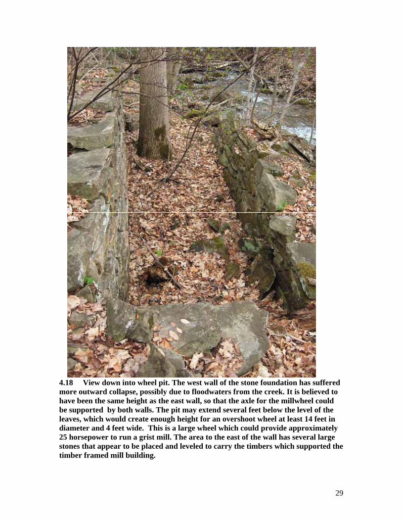
4.18 View down into wheel pit. The west wall of the stone foundation has suffered more outward collapse, possibly due to floodwaters from the creek. It is believed to have been the same height as the east wall, so that the axle for the millwheel could be supported by both walls. The pit may extend several feet below the level of the leaves, which would create enough height for an overshoot wheel at least 14 feet in diameter and 4 feet wide. This is a large wheel which could provide approximately 25 horsepower to run a grist mill. The area to the east of the wall has several large stones that appear to be placed and leveled to carry the timbers which supported the timber framed mill building.
29

4.19 In a year or two, when the house was habitable, and the large mill constructed downstream with an overshot wheel, the first mill would have been dismantled. The crib may have been adequate for the first mill, but spring floods had a way of changing the cost/benefit ratio in favour of a more permanent structure. Ironically, after 150 years, the only sign that a stone dam ever existed may be a tiny piece of mortar in a diagnostic location.
4.20 This may explain another feature of the head race that is puzzling. Why go to the effort of building a crib or dam more than 150 metres upstream only to lose between 4 and 5 feet of head by letting the water tumble down the millrace, before going into a sluice box and on to the mill downstream? The author walked the creek between the threshold of the head pond and the creek bed below the mill tail race, recording the approximate steps in the creek bottom to calculate the approximate head of water reaching the wheel. The head pond would have been 4 feet deep to reach the threshold of the race. There were 17 further steps to the point in the creek just below the tailrace, and the falls are as noted below:
4.21 Chart of vertical fall in the creek from upper pond to creek at tail race.
Step # Height Comment: 1. 48” Threshold of head race & top of next upstream ledge above head pond 2. 8” Fall between head pond and next step* 3. 18” 4. 36” 5. 12” 6. 42” Step under the bridge 7. 12” 8. 16” step below bridge where tripod was set up. 9. 12” 10. 36” 11. 18” 12. 30” 13. 8” 14. 16” Also, grade at downstream end of mill wheel (approx. 7’ above creek)** 15. 24” 16. 24” 17. 28” Step parallel with outflow from tail race. 32-1/3 feet - total fall between top of millpond and creek level at tailrace.
4.22 * This section of the creek bed is almost level, composed of smooth bedrock and is easy to cross, even with a wagon. This may mean that it was the first ford across the creek for wagons going east and west. Evidence of old wagon trails on either side of the creek may be found where the bank ramps up towards higher ground.
30

4.23 ** Note, the stone foundation is filled with an indeterminate amount of stone rubble, leaves, soil and a large tree. Currently it is about 7 feet above the level of the creek, but the original floor of the wheel box may have been several feet lower. A couple of large fallen stones near the south end of the walls indicate that a wall on this side may also have collapsed both into and out of the wheel box. These stones may have to be removed to determine the original elevation of the outflow, and it could be closer to the level of the creek. This means that a sluice which was optimized for elevation would still provide nearly 25 feet of head to the overshot wheel, unless there was a concern about elevating the sluice over the roadway. If the sluice started at an elevation below the top of the road, another 7 feet would have to be subtracted from the overall height, further reducing head for the wheel to around 18 feet. While this would be considered substantial in many locations, it might not fit with the miller’s concept of how to best use the water power at this location, which raises the question about whether the sluice started at the threshold of the millrace and ran over the roadway just east of the bridge. The road still takes a small dip on the inside curve at this point, so it is not hard to visualize the sluice passing approximately 8 feet over the roadway, with drops of cold water falling into puddles where teams would wish to take a drink as they pulled their wagon on a hot summer day.4.24 The alternative to a sluice which was elevated continuously from the head pond was that the head race might have run under the road, so that wagons could pass over it. If the sluice box were fed from a point south of the road, the original head of 32-1/2 feet would have been reduced by approximately 10 feet. Why would the builder do this if he was planning for the best way to provide wate to the mill deep in the gorge? He could have taken water from the creek 30 metres closer to the mill, at a point under the bridge, but instead went to the trouble of digging a sizeable ditch (and removing at least 720 tons of soil) plus building a dam across the creek . This makes no sense, and supports the idea that the headrace/ditch represents only the first stage of ad hoc mill construction. The dam location was ideal for generation of lots of power and represented a lot of labour. The miller would have looked at the benefits of establishing the second mill farther downstream and realized that for at least part of the distance from the head pond, water would have to be carried by a sluice box. The logical next step was to consider whether elevating the sluice box for the entire distance, made sense, rather than lose the ditch to feed the sluice box. This would not require changing dam or threshold to the mill race, but would require constructing a wooden sluice box that was approximately 130 metres long and elevated for most of its length. The sluice would also have to pass over the road at some point.
4.25 The threshold of the headrace was constructed with a more permanent stone dam, the sluice box may have been brought right to the head pond, which would have allowed the sluice to pass over the road with a clearance of nearly 9 feet. This would have preserved more elevaton for the water (called “the head” by hydrologists) to fall when it reached the mill, resulting in substantially more power from less flow. The roadway has a shallow depression on the east side of the bridge which may reflect the original road grade and elevation. If this were true, the sluice box would be too high to run in a direct line between the headpond and the millwheel, since it would soar 20 to 30 feet in the air in the lower part of the gorge.. It is more likely that the sluice box was constructed to
31

follow the best contour of the embankment, crossing the road where it would allow clearance for wagons, then along the hillside to a point directly above the mill where it was carried out to the building as a freestanding sluice. This would produce a much more power falling nearly 30 feet than if the water were carried under the road and fell only 18 feet. See sketch below
4.26 Aerial Photo alternative (110 m.) alignment of sluice boxes (route not used)
4.27 Aerial Photo of the probable (130 m.) alignment of sluice boxes for the lower mill. The additional 20 metres of sluice would bring the same volume of water from almost 10 feet (3 metres) higher.
32

4.28 Temporary mill along the excavated ditch (head race) would have required a crib or dam to operate. Why would the builder not build his first temporary mill right in the creek instead and use one of the natural falls as the head race for the machinery? One of the narrowest points on the creek, is where the bridge was constructed. The falls at this point are 4’ high. A pair of small stone walls could have directed the entire flow of the creek through a narrow gap or 3 or 4 feet, and driven an undershot wheel, mounted on bearing blocks on either side of the gap. This is an attractive option if it were being considered as a single short term plan to cut lumber. However, the ditch/millrace is a fact that cannot be ignored. Logically, someone would not build the millrace to drive a temporary sawmill, unless they had planned further and decided to use the dam and millrace as part of the second stage mill construction. Rather than set up a temporary mill in what was otherwise the most efficient location (at the bridge), they decided to construct the millpond, build the house and then construct the sluice and mill, probably no earlier than the following year. If the date for construction of the house is 1856, one would expect that the sluice, dam and mill would have taken at least one more year. This would mean that the mill might have been operational by 1858 or ’59
4.29 While there is little evidence for the location of the sawmill in the head race (ditch) other than logic, it does support the case for the eventual route that the sluice would have had to take to the lower mill. The proximity of the early mill (approximately 40 metres from the house and halfway between the road and the pond, would have made skidding sawn logs to the house much easier than lifting the logs back up the 40 foot embankment from the level of the lower mill wheel. The pile of dressed stone, and way that the head race “disappears” in the downhill slope soon after this location, suggest that some sort of temporary platform for cutting logs was constructed here for the sawmill enterprise. This may have consisted of a few heavy timbers with a plank floor and frame to support the “English Gate” style of rip saw, and little else, since cutting would probably be seasonal and in good weather only. .4.30 The altitude measuring tool in Google, indicates that the difference in elevation of the creek bed between the head pond & this temporary mill location of 4 feet. The dif- ference between the pond & the tailrace is much greater, 37 feet. The change of elevation estimated visually (by checking each steps in the creek), is 32-1/3 feet, close to the Google value. The permanent mill utilized the much larger change in elevation.
5.0 THE BRIDGE:
5.01 The construction of a stone arch bridge on what was a side road where it crossed a small creek, is exceptional. Stone bridges like this are common in the U.K. but very rare in rural Ontario, except where a town like Kingston or Guelph grew up around a small rural settlement. This would normally suggest foresight and determination on the part of someone who was trying to improve transporation and development, locally. Most early bridges were constructed quickly and easily in timber, especially when they spanned small creeks like this one. Why would anyone go to this sort of trouble, particularly when
33

the bridge required several hundred tons of material for the construction? There are three possible reasons.
A.) An Individual owner was able to take advantage of the finished bridge for financial gain, as with a toll bridge
B) The creek crossing used by wagons for many years was no longer possible for some reason. Perhaps a dam was constructed which blocked the water and flooded the crossing making it too deep for crossing.
C) The owner had a ready supply of building material close to the work site.
D) individual. The most likely candidate for this being The Canada Company, which is described in Wikipedia, as follows:
5.02 “” The Canada Company was a large private chartered British land development company, incorporated by an act of British parliament on July 27, 1825, to aid the colonization of Upper Canada. Canada Company assisted emigrants by providing good ships, low fares, implements and tools, and inexpensive land. Scottish novelist, John Galt, was the company's first Canadian superintendent. The government of Upper Canada sold the company 10,000 km² of land for 341 000 pounds. Slightly less than half of the land that was purchased comprised what would become the Huron Tract, located on the eastern shore of Lake Huron, the remainder, located in other areas of Upper Canada, became Clergy reserves under the control of the Clergy Corporation. Galt selected Guelph, Ontario as the company's headquarters. The company surveyed and subdivided this massive area, built roads, mills, and schools and advertised it to buyers in Europe. The company then assisted in the migration of new settlers, bringing them to the area by means of a boat, which the company also owned, on Lake Ontario.
The company's mismanagement and corruption, and its close alliance with the Toryelites, known as the Family Compact was an important contributing factor to the Upper Canada Rebellion in 1837.
The company was dissolved on December 18, 1953. “” Wikipedia
5.02 The idea that the bridge was constructed by the Canada Company is tempting since it fits the methodology of their business plan. However, we have no evidence that anyone was living in the vicinity of the creek before McClure. There is also the problem of what happened to the dam at the millpond. The disappearance of hundreds of tons of fill or stone from the dam suggests that the bridge may have been built from materials reclaimed from this structure. This would mean that it was built after the mill (and pond) ceased to exist. Since the property value plummeted in from $5925 in 1874 to $306 in 1877, the mill must have disappeared as an asset. The value of the land could only fall this much if the mill and infrastructure was gone. Perhaps the mill burned, or a storm destroyed both the dam and the mill. In either case the dam would be seen as a uneconomical to re-construct. It is also unlikely that the bridge was constructed before
34

settlement and industry began. The owner for many years after 1877 was Donald McKay, who appears to have been responsible for constructing the masonry foundation on the north side of the house. McKay like many Scots would view stone as a building material that he was familiar with, so it would make sense that the simple rubble masonry of the bridge and the wall of the house less than 100 metres away, might be from the same trowel. This makes the bridge a significant part of the history of the McClure / McKay property, as well as an architectural gem.
5.03 How was the creek crossed before the bridge. The earliest trails used fords across creeks occurred upstream at points where the animals and loaded wagon could safely cross the water in most seasons. The reason that Dundas Street (as one of the earliest east-west route across the province) runs miles inland from Lake Ontario is that travelers found that trying to cross creeks and rivers any closer to the lake was impossible without bridges (that had yet to be built), The trail or road had to be get teams and wagons safely down the valley and across the stream. The field west of the creek has traces of old wagon tracks running to the west-north-west over the hill. I suspect that the original location for crossing the creek was a ford just north of the bridge where the banks of the creek are low, the bottom of the creek as smooth and level as pavement, and a “natural” ramp exists on the west side that would allow a wagon to climb the 6 foot embankment. Coincidentally, this probable ford was within spitting distance of where the dam came to be, so the special characteristics of this part of the creek would have been well known to travellers before 1854 when McClure bought the property, unless someone had taken the trouble to actually construct a log bridge at this time. Constructing roads along the edge of your property as well as clearing five acres was a precondition of taking up ownership of crown land. Since McClure seems to be the first resident within a half mile of the creek crossing, it is most likely that he would be responsible for any improvements to what was otherwise the easiest trail across country.
5.04 The Canada Company held the property from 1841 to 1854 perhaps hoping that they could develop milling on the site, but sold the property when they realized that the area was not developing as a large grain producer. McClure proceeded to establish the mill and construct his farm, but eventually sold the 26.5 acres to Smith and MacDonald in 1869. MacDonald assumed sole ownership in 1871, then sold to Charles Symon and David Allan. The subsequent mortgage with Ontario Bank for $5925 in March 1873 represented a very large investment for a small farm like this, so must have included an asset such as a mill. In the same month, legal action was taken by MacDonald against Symon and Allan for the 26.5 acres. The following month David Allan took another mortgage with John Allan, and Charles Symon’s interest was assigned to Wm. Alan. The following year David Allans interest was given in “quit claim” to the Ontario Bank meaning that he has defaulted on his payments and lost ownership of the property. Ownership between 1874 and 1877 rested with William Allan (who may the father or uncle of David Allan),.and the Ontario Bank, but in March 1877 the property had another mortgage between Donald McKay and Samuel Irwin, this time for $306. While this last transaction appears to be for 4.75 acres the balance of the property 21.75 acres is sold in 1877 by Donald McKay to Henry Plomeux with a mortgage of $100. It would appear that the property lost most of its value during the time that it was in dispute and changing
35

hands (March 1873 to March 1877). This probably means that the mill, dam and structures other than the house were lost during this time. This fits well with the idea that the permanent mill was constructed after the house 1856 or 1857 but lost by 1877. It also raises questions as to whether the potentially bitter legal dispute and loss of the buildings were connected in some way. Did the mill disappear in a fire? Evidence of a fire might be found buried in the soil if pieces of charred timber were left behind. Even if the building simply collapsed when it deteriorated it would leave evidence buried in the soil. This could be resolved by an archaeologist. Other pieces of mill machinery and perhaps the mill stones might also be buried on site if they were not pulled out of the building when the business failed.
5.05 The coved clapboard siding and frame kitchen addition which appears to be at least ten years later than the log house, so may have been constructed before Symon and Allan took over the property, possibly by John MacDonald in 1872. With the estate in turmoil, and the mill failing it much more likely that Donald McKay built the addition after 1877 during his long ownership of the property. Circumstantially, it makes more sense that the bridge would be built by McKay since the rubble masonry addition to the north side of the house also seems to be by his hand.
5/06 Silver Creek Bridge (sandstone bedded in lime mortar, single vault) Note modern concrete abutments added to reinforce base of arch, and wooden railing installed on concrete cap laid over masonry. © T.Murison 2008
36
5.07 This is a rare and beautiful example of a true masonry arch bridge. The bridge is sound but should be examined to see if the original pointing needs to be replaced. It has been repaired with concrete abutments at water level and along the edge of the road deck, probably after damage caused by a heavy flood which overtopped the bridge in 1952. A thunderstorm one night in July 1952, was reported by the Gates family to have caused the house to shake (100 metres away) as the flood water poured over the top of the bridge. It is believed that the parapets were destroyed by this storm because municipal workers subsequently repaired the bridge with concrete that is seen today.
5.08 The pressure treated post and cable railing is failing, so it is a perfect time to have the bridge repaired to the way it originally was. The gravel roadway is used by local traffic on No. 27 side road.
5.09 This is and important and rare rural bridge. It is due for maintenance and deserves to have the masonry parapet reconstructed to a level 3 feet above the road surface, in matching stone. This would require a skilled mason but would restore the bridge to a condition which is both authentic and functional.
6.0 CONDITION ASSESSMENT OF THE LOG BUILDING &RECOMMENDATIONS FOR RESTORATION:
6.01 The foundations and interior crawl space were not accessible. From the north side of the house it was possible to see the rubble foundations, and make several observations. The masonry is local sandstone, laid up in a lime mortar with flush joints. Inclusions of
37

lime and the coarse sands, indicate that the components for the mortar were probably from the site. It is likely that limestone was burnt nearby to make the quicklime which was subsequently slaked for the mortar. The foundation wall has weathered close to grade with some loss of the lime binder, and evidence of deterioration of the mortar within the wall. This is exactly what one would expect after this length of time. Any rubble wall, whether in the foundation or retaining wall at the rear of the building, should be exposed, examined, tested and repointed,. The retaining wall has been backfilled with approximately 7 feet of soil, so would require an excavation of the exterior down to the level of the footings, in order to repair and waterproof the foundation. The generally good slope around the house, would facilitate drainage, if a weeping tile were installed on the north side of the house. While it is not, absolutely necessary to do this, long term use of the building, in a seasonal way, would require better management of the surface drainage to prevent deterioration of the log and frame structures. The C.V.C.A. has already replaced a lower log and siding on the north side of the building to deal with this problem, so part of the work has been done on the north-west corner of the building.
6.02 Where the interior of the masonry walls are found to have lost the lime binder in the mortar, grouting or consolidation may be necessary.
6.03 The log walls of the original building are, where exposed, in extremely good condition due to the early application of siding over an airspace on the entire exterior surface of the building. Examination of areas like window and door sills, service openings, and the interface between logs and foundation may reveal localized deterioration caused by excessive humidity or water penetration. These areas can probably be repaired without major replacements of material.
6.04 The white insulation between the logs and siding may be Ureaformaldehyde insulation, (UFI) which gained notoriety in the short time that it was in use. The insulation has deteriorated, (at least where exposed to the elements), and may have stopped outgassing formaldehyde entirely, so allowance should be made to remove it only where exposed by work. The toxic characteristics of the UFI and best methods of disposal are not relevant for this report, but should be done only where necessary.
6.05 The siding on the house is in good condition, except where opened for repairs and review of the wall. New or reclaimed material should be used to repair the siding. The siding has been painted quite a few times, and is beginning to crack and delaminate in some areas. If it is determined that the siding should not just be repainted, but stripped, primed and repainted, the old paint could be removed mechanically or with the application of heat. The probable use of lead and even mercury in some layers of older paint, make heat stripping dangerous. Mechanical removal only makes sense if a specialized paint removal machine is used. These are specialty tools which are available from the U.S..
6.06 The shingle roof has been replaced and maintained well. The current asphalt shingles may not be appropriate if the building were to be saved as an interpretive building, so consideration of traditional roofing materials, and specifically cedar shingles
38
would be necessary. Cedar shingles can have a much longer life if properly installed. In some German and Swiss churches, the shingle roofs can last up to 250 years. For a building such as this, the original shingle detail would need to be upgraded to allow for ventilation and modern flashings. Details such as insect protected vents are beyond what is necessary for this report, but should be reviewed with great care, in any proposal for restoration.
6.07 The two-over-two windows in the house are replacement windows from the 1890’s. While they may continue to function well, if repaired and repainted, an accurate restoration, the original 1856 6/6 sash windows were almost certainly constructed with 8” x 10” panes since the dimensions of the rough opening fit this exactly. Restored windows would have to use the correct muntin profile, type of glass (blown - bottle glass), and traditional linseed putty. Storm windows and/or shutters may also be required for security and protection of the interior. Things like security films which double as U.V. barriers to protect interior artifacts should also be examined in the restoration proposal.
6.08 The brick chimney may or may not be original to the house. The chimney top should be reconstructed to match traditional details if the chimney is to be retained. If a period iron stove is to be installed again, it would require fire protection measures, and an exposed stove pipe inside the living room, for authenticity. The chimney would also require a stainless steel liner in order to allow the stove to function.
6.09 The floors of the house are in good condition. Most of the wood floors were refinished and protected from damage until the building was hoarded, so could be used with little maintenance.
6.10 The stairs are narrow and steep. This makes access to the second floor slightly more difficult than in modern houses, but is acceptable in an historic house. Handrails both sides might be a better safety option.
6.11 In general, this house is in remarkably good condition for its age, and could easily be restored as a useable space for specific purposes, except perhaps, residential occupation.
7.0 CONCLUSIONS:
7.01 This Conservation Area contains land which has been occupied by people for at least 500 years. Indigenous people settled on the property and constructed a village with substantial long house, palisade and gardens a short distance upstream from the bridge. Presence of this village was noted on aerial photographs during the research into the site. Excavation pits, and markers were left by archaeologists when they completed their work. This site is now covered with natural vegetation.
7.02 The creek was used for resources such as fish, and would have been a traditional route for traveling inland from Lake Ontario. Several deep pools along the creek were habitat for fish as late as the 1950’s. Salmon and trout may find this creek good spawning
39
habitat even though it has many small “steps” going upstream. The characteristics of the landscape that make it attractive today, were probably noted millennia before the late woodland occupation of the site. This is an archaeological “hot spot” along the lines of Crawford Lake and may have been home to 150 people before European settlement. Jesuit records of the demise of the Neutrals and Algonquins during Queen Annes War (1752) suggest that most if not all of the villages within 50 miles of the north shore of Lake Ontario were attacked and destroyed by the Iroquois. An archaeological report would have resulted from the excavations on the site. This report might explain what happened to native settlement on the site, and whether the village was attacked and destroyed as others were.
7.03 The Canada Company (est’d.1825) owned the property, (along with 1.5 million acres of Ontario) until 1854 when it was sold to William McClure. It is unclear if the site was occupied before 1854, but entirely possible that the Canada Company was aware of the water power potential of the creek for milling.
7.04 William McClure purchased the property from the Canada Company and constructed house in 1856. a The trees were winter cut (1855-56) and sawn not hewn. The logs are were assembled with some unusual details including a half-dovetail in the top gable log, which was intended to prevent spreading of the walls. Oak trenails were probably used in the top logs on the long walls of the house.
7.05 The house was similar to small settlers houses built after 1820 but used a “modern” iron stove for heat, not the more typical central fireplace. The logs inside the house were whitewashed, and it had an attic that was not finished until the middle of the 20th. century. The existing windows 2/2 are late 19th. century replacements for the typical 6/6 single hung sash windows, (glass panes 8” x 10” ). The house was extended with a frame addition on one side, either in 1872 by John MacDonald, or more likely after 1874by Donald McKay. The clapboard siding, trim on the doors and windows, frame addition on the east side and masonry addition on the north side of the house are more likely the work of Donald McKay, who was descended from crofters from the highlands of Scotland (north of Inverness).
7.06 A sawmill was in operation and predated the house. Remains of the head race north of the bridge as well as modifiations to the stone in the creek and mortar along the bank indicate that a dam containing sandstone quarried from the creek was constructed to create a pond at least 4 feet deep, and divert the water through an excavated ditch towards the east end of the bridge.
7.07 There is also evidence that the bridge was predated by a ford across the creek in the vicinity of the dam, and that this wagon road may have split just west of the creek with one trail proceeding south-west past the top of Eighth Line, and the other trail going north-west, uphill over the field flanking the creek.
7.08 The sawmill may have been a simple rip-saw mounted in a vertical frame called an “English Gate” and would have been driven by linkage to an undershot wheel. This
40

sawmill allowed the large logs to be cut to dimension for construction of the house, and would have ripped the flooring, and roof sheathing as well as timbers for the more permanent mill, located downstream.
7.09 A grist mill or combination grist mill and sawmill was constructed after1856 and remained in use until 1869 approximately 130 metres downstream from the millpond. This mill was driven by an overshot wheel which sat on dry laid stone foundations. The millwheel was probably 14 feet in diameter and 4 feet wide. Water was carried in a wooden sluice from the pond to this mill which has a tailrace elevation at least 32 feet lower than the threshold of the sluice at the pond. In times of adequate flow this would easily drive a heavy millstone requiring 25 horsepower. The millstone and remnants of the mill building have not been found but could be buried under the debris, vegetation and soil that has accumulated on site. The mill fell out of use before 1877 in the midst of lawsuits, repossessions and several changes of ownership. It appears that the mill was destroyed or perhaps lost in a fire by March. 1877 because the value of the land and buildings plummeted from $ 5925 in 1873 to $ 306 in April1877. The mill was probably constructed by William McClure so should be known as the McClure Mill site.
7.10 When ownership of the land passed to Donald McKay in 1877 the 26 acre property was used as a farm.
7.11 The bridge was constructed sometime after 1877, likely using the stone from the dam upstream. It remains in use after 140 years as a rare barrel vaulted, single arch,rubble stone bridge. The parapets and foundations were damaged by a severe thunderstorm in 1952, and were repaired with concrete.
7.12 The land was owned by the Vaughan family, until ownership passed to the Credit Valley Conservation Authority. It is used as a Conservation Area and contains rare species of plants and animals.
7.13 The McClure Log House was part of an important collection of buildings including a stone dam, stone bridge, saw mill and grist mill. Demolition of the house would leave only the stone bridge from this collection of important early structures, which provide a record of the struggle of settlers and farmers to develop the land and prosper in what was, for most of them, their new country. The site has been occupied and modified by native and European settlers for more than 500 years. It contains important archaeological and architectural resources that must be preserved, as well as a diversity of natural habitat, plants and animals. The community including Friends of Fallbrook, Municipality of Halton Hills, Credit Valley Conservation Authority, and Government of Ontario should work together to preserve and best utilize all of these features which make this site as culturally important to as places like Crawford Lake and St. Marie among the Hurons.
41
8.0 ACKNOWLEDGEMENTS:
Research Ian McGillivray Architect, Architectural and Historical Report McClure – Vaughan House 14513 – 27 Side Road, Esquesing Twp.
Sandy-James McKay, McKay descendent John & Irene Carroll, McKay descendent Joan Kadoak Wayne Gates, McKay descendent & former resident Michael Vaughan, Rob Keir, former resident Peter Devine, restoration mason
`Access to the House Brian Kristy Property Superintendent & Judi Orendorff Manager Credit Valley Conservation Authority
Advice and Support Tamara Anson-Cartwright and Ontario Heritage Foundation Rollo Myers, Architectural Conservancy of Ontario
42
43
Quotes from a report for the OHF, 1985 sent by Wayne, March 25th. 2008.
Across the northwesterly section of the farm, a broad band of deep tills forms part of the Acton Moraine. Much of this formation has developed in a classic "knob and kettle" pattern with pockets of poor drainage in a few of the deeper kettles. The underlying till of this formation is a diverse mixture of sand, boulders, and rock fragments. Surface soils have been classified as Dumfries loam, which are moderately fertile but susceptible to erosion on steeper slopes. Archaeological Zone One: (Referring to the Wylie Place and the far field there) Located on the northernmost agricultural field of the park, Archaeological Zone One is comprised of a native village recorded as Emmerson Springs Village with the Ministry of Culture, Tourism and Recreation. A preliminary field survey in 1984 indicated that the site, located on the terraced plateau overlooking Owl Creek to the southwest was once a year round community containing longhouses. Artifacts discovered here are similar to those found in the nearby Wallace site. The importance of the site is not clear as questions remain about the origin, lifestyle, and ultimate fate of the native villagers.