Embed Size (px)
Citation preview
APPENDIX A Scoping Letter and NOP Comments

1222 First Avenue, Mail Station 301 San Diego, CA 92101- 4101 [email protected]
T (619) 446-5000 sandiego.gov
February 28, 2020 Mr. Jonathan Frankel, Project Manager New Urban West San Diego, CA 92130 SUBJECT: The Trails at Carmel Mountain Ranch Project (Project Tracking System (PTS) No.
652519) - Scope of Work for an Environmental Impact Report Dear Mr. Frankel: Based on review of the project application and pursuant to Section 15060(d) of the California Environmental Quality Act (CEQA), the Environmental Analysis Section (EAS) of the City’s Development Services Department has determined that the proposed project may have significant effects on the environment and the preparation of a project-level Environmental Impact Report (EIR) is required. The purpose of this letter is to identify the specific issues to be addressed in the EIR. The EIR is required to be prepared in accordance with the “City of San Diego Technical Report and Environmental Impact Report Guidelines” (updated December 2005). A copy of the current guidelines is attached. A Notice of Preparation (NOP) will be distributed to the Responsible Agencies and others who may have an interest in the project as required by CEQA Section 15082. Scoping meetings are required by CEQA Section 21083.9(a)(2) for projects that may have statewide, regional or area-wide environmental impacts. The City’s environmental review staff has determined that the project meets this threshold and a scoping meeting will be held prior to preparation of the EIR. Therefore, the scoping meeting, has been scheduled for Wednesday March 18th, 2020 at the Carmel Mountain Ranch Recreation Center, located at 10152 Rancho Carmel Drive, San Diego CA 92128. The meeting will be from 6:00 PM to 8:00 PM to gather input. Please note, depending upon the number of attendees the meeting could end earlier than 8:00 PM. Changes or additions to the scope of work may be required as a result of input received in response to the Notice of Preparation and Scoping Meeting. In addition, the applicant may adjust the project through the discretionary review process and these changes are required to be disclosed in the “History of Project Changes” section of the EIR and accounted for in the EIR impact analysis to the extent required by CEQA.
Page 2 Mr. Jonathan Frankel February 28, 2020 Each section and issue area of the EIR shall provide a descriptive analysis of the project followed by a comprehensive evaluation. The EIR shall also include sufficient graphics and tables in conjunction with the relevant narrative discussions to provide a complete a meaningful description of all major project features, the environmental impacts of the project, as well as cumulative impacts, mitigation of significant impacts, and alternatives to the project. PROJECT DESCRIPTION The Trails at Carmel Mountain Ranch Location of Project The project site is a 164.5-acre former 18-hole golf course located at 14050 Carmel Ridge Road, San Diego, CA 92128. The project site is located west of the City of Poway, east of the community of Rancho Penasquitos, north of the community of Saber Springs, and south of the community of Rancho Bernardo. The project site is bound by Ted Williams Parkway to the south; Carmel Mountain Road to the north; Interstate 15 (I-15) to the west; and the boundary with the City of Poway to the east (see Figure 1, Project Location). The site is primarily characterized by disturbed, fallow land left over from the previous golf course use. Zoning designations of the project site include RM-1-1, RM-1-2, RM-1-3, RM-2-4, RM-2-5, RM-2-6, RM-3-7. The site is currently designated as Park, Open Space, and Recreation in the City’s General Plan (City of San Diego 2008). Land uses surrounding the project site include residential development in all directions, including single-family and multi-family residential. Various commercial and employment uses are also located adjacent the project site. For instance, the Carmel Mountain Plaza is located north of the project site and provides a wide variety of stores, commercial amenities, and office space. Further, approximately 43 acres of existing office development is located immediately southwest of the project site, south of Ted Williams Parkway and west of Saber Springs Parkway. Native habitat associated with Chicarita Creek is present along the western boundary of the project area. Project Description The proposed project is approximately 1,200 multi-family homes and a mix of open space and recreational uses. Residential land uses would compose approximately 51 acres and would range in density from 14.5 to 43.5 dwelling units per acre. Open space uses are proposed on approximately 113 acres, which includes over 6 miles of publicly- accessible trails (see Figure 2, Site Plan). Residential land uses would be developed as infill residential neighborhoods based on the standards in the proposed Trails at Carmel Mountain Ranch Design Guidelines. The various components of the proposed project are described in more detail below. Residential Land Use The project would include 251 townhomes on approximately 16 acres, 586 market-rate apartments on approximately 21 acres, 120 affordable apartments on approximately 6 acres, and 243 apartments for 55-and older residents on approximately 8 acres. A variety of building types will be provided in the community, with a mix of for-sale, rental and age-restricted product to serve a diverse and mixed population and household size.
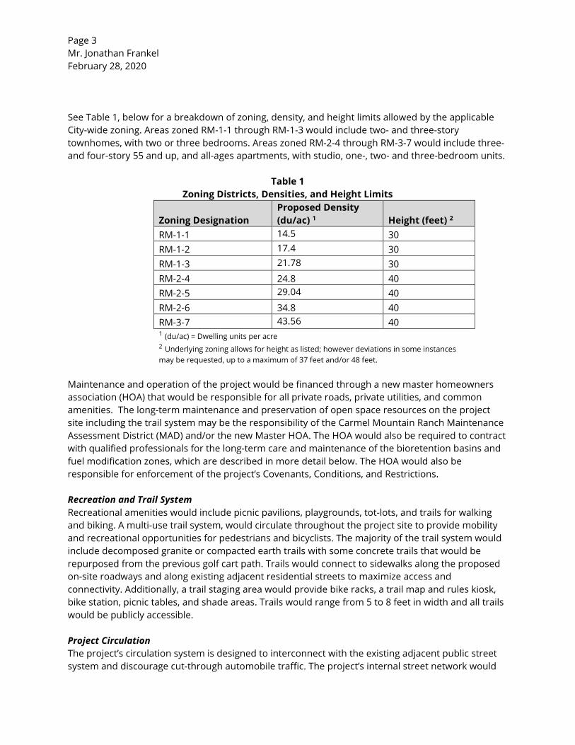
Page 3 Mr. Jonathan Frankel February 28, 2020 See Table 1, below for a breakdown of zoning, density, and height limits allowed by the applicable City-wide zoning. Areas zoned RM-1-1 through RM-1-3 would include two- and three-story townhomes, with two or three bedrooms. Areas zoned RM-2-4 through RM-3-7 would include three- and four-story 55 and up, and all-ages apartments, with studio, one-, two- and three-bedroom units.
Table 1 Zoning Districts, Densities, and Height Limits
Zoning Designation Proposed Density (du/ac) 1 Height (feet) 2
RM-1-1 14.5 30 RM-1-2 17.4 30 RM-1-3 21.78 30 RM-2-4 24.8 40 RM-2-5 29.04 40 RM-2-6 34.8 40 RM-3-7 43.56 40 1 (du/ac) = Dwelling units per acre 2 Underlying zoning allows for height as listed; however deviations in some instances may be requested, up to a maximum of 37 feet and/or 48 feet.
Maintenance and operation of the project would be financed through a new master homeowners association (HOA) that would be responsible for all private roads, private utilities, and common amenities. The long-term maintenance and preservation of open space resources on the project site including the trail system may be the responsibility of the Carmel Mountain Ranch Maintenance Assessment District (MAD) and/or the new Master HOA. The HOA would also be required to contract with qualified professionals for the long-term care and maintenance of the bioretention basins and fuel modification zones, which are described in more detail below. The HOA would also be responsible for enforcement of the project’s Covenants, Conditions, and Restrictions. Recreation and Trail System Recreational amenities would include picnic pavilions, playgrounds, tot-lots, and trails for walking and biking. A multi-use trail system, would circulate throughout the project site to provide mobility and recreational opportunities for pedestrians and bicyclists. The majority of the trail system would include decomposed granite or compacted earth trails with some concrete trails that would be repurposed from the previous golf cart path. Trails would connect to sidewalks along the proposed on-site roadways and along existing adjacent residential streets to maximize access and connectivity. Additionally, a trail staging area would provide bike racks, a trail map and rules kiosk, bike station, picnic tables, and shade areas. Trails would range from 5 to 8 feet in width and all trails would be publicly accessible. Project Circulation The project’s circulation system is designed to interconnect with the existing adjacent public street system and discourage cut-through automobile traffic. The project’s internal street network would
Page 4 Mr. Jonathan Frankel February 28, 2020 consist of private driveways. All private drives would include a minimum five-foot sidewalk along at least one side of the street. Motor courts would also be provided as a shared driveway (private drive) for two or more homes and common access roads would provide access from private drives to parking areas. Project Infrastructure Project Water System: Connections will be made to existing City water and sewer infrastructure to provide service to the project as described below under Project Water System and Project Wastewater System. Improvements to the public water system include a new 12-inch 793 Pressure Zone water line to serve Unit 5 and Unit 6, and the relocation of an existing 8-inch 1130 Pressure Zone water line through Unit 9/18. Each Unit within the project is proposed to have a private domestic water system and a private fire protection system. In accordance with City of San Diego standards, private domestic water systems will include a meter and backflow preventer, and private fire protection systems will include backflow preventers. Project Wastewater System: The project would construct new gravity sewer lines to connect the project site to the existing gravity sewer system. Unit 5 will require a lift station to serve the project. Onsite sewer systems will be private and will be designed to maintain a minimum of one percent slope to meet state and local plumbing code standards. Alternatively, the private sewer systems within each Unit would be designed in accordance with the City of San Diego Sewer Design Guide. Project Dry Utilities: Electrical power and natural gas would be provided by San Diego Gas & Electric. No major improvements to the local distribution networks are anticipated to be needed to support the growth facilitated by the proposed project. Off-Site Improvements Offsite improvements include the installation of a new traffic signal at the intersection of Carmel Ridge Road and Ted Williams Parkway. Construction and Phasing Development of the project site would occur in phases and would not be entirely built out all at the same time. As shown in Figure 3, Proposed Phasing, Units 1, 9, western half of 16, and 17 would be built out during Phase 1; Units 2, 8, and eastern half of 6 would be built out in Phase 2; Units 5 and the western half of 6 would be build out in Phase 3; Units 10 and 11 would be built out in Phase 4; Units 7, 13, and eastern half of 16 would be built out in Phase 5. Discretionary Actions The project requires the following entitlements from the City, which would be processed concurrently unless otherwise noted:
• General Plan Amendment to redesignate Park, Open Space and Recreation to Residential and Open Space.
• Community Plan Amendment to redesignate “Private Recreation-Golf Course” to Low-Medium Density Residential, Medium Density Residential, Open Space, and Other Open Space.
Page 5 Mr. Jonathan Frankel February 28, 2020
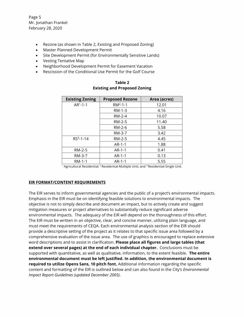
• Rezone (as shown in Table 2, Existing and Proposed Zoning) • Master Planned Development Permit • Site Development Permit (for Environmentally Sensitive Lands) • Vesting Tentative Map • Neighborhood Development Permit for Easement Vacation • Rescission of the Conditional Use Permit for the Golf Course
Table 2
Existing and Proposed Zoning
Existing Zoning Proposed Rezone Area (acres) AR1-1-1 RM2-1-1 12.01
RM-1-3 4.16 RM-2-4 10.07 RM-2-5 11.40 RM-2-6 5.58 RM-3-7 3.42
RS3-1-14 RM-2-5 4.45 AR-1-1 1.88
RM-2-5 AR-1-1 0.41 RM-3-7 AR-1-1 0.13 RM-1-1 AR-1-1 5.55
1 Agricultural Residential; 2 Residential-Multiple Unit; and 3 Residential-Single Unit. EIR FORMAT/CONTENT REQUIREMENTS The EIR serves to inform governmental agencies and the public of a project’s environmental impacts. Emphasis in the EIR must be on identifying feasible solutions to environmental impacts. The objective is not to simply describe and document an impact, but to actively create and suggest mitigation measures or project alternatives to substantially reduce significant adverse environmental impacts. The adequacy of the EIR will depend on the thoroughness of this effort. The EIR must be written in an objective, clear, and concise manner, utilizing plain language, and must meet the requirements of CEQA. Each environmental analysis section of the EIR should provide a descriptive setting of the project as it relates to that specific issue area followed by a comprehensive evaluation of the issue area. The use of graphics is encouraged to replace extensive word descriptions and to assist in clarification. Please place all figures and large tables (that extend over several pages) at the end of each individual chapter. Conclusions must be supported with quantitative, as well as qualitative, information, to the extent feasible. The entire environmental document must be left justified. In addition, the environmental document is required to utilize Opens Sans, 10 pitch font. Additional information regarding the specific content and formatting of the EIR is outlined below and can also found in the City’s Environmental Impact Report Guidelines (updated December 2005).
Page 6 Mr. Jonathan Frankel February 28, 2020 I. CERTIFICATION
Prior to the distribution of the draft EIR for public review, Certification pages, which are attached at the front of the draft EIR, will be prepared and provided by EAS to the consultant.
II. TITLE PAGE
The EIR shall include a Title Page that includes the project name, Project Tracking System (PTS) number, State Clearinghouse (SCH) number, and the date of publication. DO NOT include any applicant’s or consultant’s company logos or names.
III. TABLE OF CONTENTS
The Table of Contents must list all sections included in the EIR, as well as the Appendices, Tables, and Figures. Immediately following the Table of Contents, a list of acronyms and abbreviations utilized in the text must be provided.
IV. EXECUTIVE SUMMARY
The consultant will prepare the Executive Summary to be submitted for review with the last internal draft EIR screencheck, unless otherwise determined. The Executive Summary shall have an independent numbering system (e.g., ES-1, ES-2). In general, the Executive Summary should reflect the EIR outline, but need not contain every element of the EIR. At a minimum, the Executive Summary must include the following sections: a brief discussion of the purpose and scope of the EIR; project location and setting; project objectives and a brief project description; impacts determined to be significant (including cumulative); impacts determined to be less than significant; areas of controversy; issues to be resolved by the decision-maker; alternatives; and lastly, a matrix listing the impacts and mitigation. Please refer to the Environmental Impact Report Guidelines (2005) for further detailed information.
V. INTRODUCTION
The EIR shall introduce the project with a brief discussion on the intended use and purpose of the EIR. This discussion shall focus on the type of analysis that the EIR is providing and provide an explanation of why it is necessary to implement the project. This section shall describe and/or incorporate by reference any previously certified environmental documents that cover the project site including any EIRs. This section shall briefly describe areas where the project is in compliance or non-compliance with assumptions and mitigation contained in these previously certified documents. Additionally, this section shall provide a brief description of any other local, state, and federal agencies that may be involved in the project review and/or any grant approvals.
Page 7 Mr. Jonathan Frankel February 28, 2020 VI. ENVIRONMENTAL SETTING
The EIR shall describe the precise location of the project with an emphasis on the physical features of the site and the surrounding areas and present it on a detailed topographic map or aerial photograph and regional map. This section shall also include a map(s) of the specific proposal and discuss the existing conditions on the project site and in the project area. In addition, the section shall provide a local and regional description of the environmental setting of the project, as well as the zoning and General Plan/Community Plan land use designations of the site and its contiguous properties, area topography, drainage characteristics, and vegetation. It shall include any other applicable land use plans such as the City’s MSCP/MHPA, environmentally sensitive lands [steep slopes, wetlands, Federal Emergency Management Agency (FEMA), 100-year floodplain and/or floodway that may intersect the project components], and other applicable open space preserves or overlay zones that affect the project site. The section shall include a listing of any open space easements or building restricted easements that exist on the property. A description of other utilities that may be present on or in close proximity to the site and their maintenance accesses shall also be discussed. Provide a recent aerial photo of the site and surrounding uses, and clearly identify the project location. This section will also describe the environmental baseline within the context of the ongoing operations, if applicable.
VII. PROJECT DESCRIPTION
The EIR shall include a statement of the goals and objectives of the project, in terms of public benefit (increase in housing supply, employment centers, etc.). The objectives should also include the underlying purpose for the project. Project objectives are critical in determining the appropriate alternatives for the project, which would avoid or substantially reduce potentially significant impacts. As stated in CEQA Guidelines Section 15124(b), “A clearly written statement of objectives will help the lead agency develop a reasonable range of alternatives to evaluate in the EIR and aid the decision makers in adopting findings and/or a statement of overriding considerations, if necessary. Therefore, the goals and objectives should be clear and concise.
This section shall describe all discretionary actions needed to implement the project (e.g. General Plan amendment, community plan amendment, specific/master plan amendment, rezone, Tentative Map, easement vacations, amendments to any existing permits, and any new permit) including all permits required from federal, state, and local agencies. If other agencies have responsibility for approvals or project review, describe this involvement. The description of the project shall include all major project features, including development density, grading (cut and fill), relocation of existing facilities, land use, retaining walls, landscaping, drainage design, improvement plans, including any off-site improvements, vehicular access points, and parking areas associated with the project. The project description shall describe any off-site activities necessary to construct the project. The EIR shall include sufficient graphics and tables to provide a complete description of all major project features. Project phasing shall also be described in this section. This discussion shall address the whole of the project.
Page 8 Mr. Jonathan Frankel February 28, 2020 VIII HISTORY OF PROJECT CHANGES
This section of the EIR shall outline the history of the project and any physical changes that have been made to the project in response to environmental concerns identified during the review of the project (i.e. in response to City’s review of the project, the NOP, public scoping meeting, or during the public review period for the draft EIR).
IX. ENVIRONMENTAL IMPACT ANALYSIS
This section shall analyze those issue areas having the potential for resulting in significant environmental impacts due to the effects of the project. Impacts must be thoroughly analyzed and mitigation measures identified that would avoid or substantially lessen any significant impacts. The City of San Diego is the Lead Agency for this project, and therefore the EIR must represent the independent analyses of the Lead Agency. Accordingly, all impact analysis must be based on the City’s “Significance Determination Thresholds” (January 2016), unless otherwise directed by the City. Below are key environmental issue areas that have been identified for this project, within which the issue statements must be addressed individually.
Discussion of each issue statement shall include an explanation of the existing project site conditions, impact analysis, significance determination, and appropriate mitigation. The impact analysis shall address potential direct, indirect, and cumulative impacts that could be created through implementation of the project and its alternatives. Lastly, the EIR shall summarize each required technical study or survey report within each respective issue section, and all requested technical reports must be included as appendices to the EIR and summarized in the text of the document. Furthermore, as required by CEQA Sections 15140 and 15147, please ensure the environmental document is written in plain language and avoids highly technical terminology and analysis.
In each environmental issue section, mitigation measures to avoid or substantially lessen impacts must be clearly identified and discussed. The ultimate outcome after mitigation should also be discussed (i.e., significant but mitigated, significant and unmitigated). If other potentially significant issue areas arise during the detailed environmental investigation of the project, consultation with Development Services Department is required to determine if these areas need to be added to the EIR. As supplementary information is required, the EIR may also need to be expanded.
Land Use
Issue 1: Would the project result in a conflict with the environmental goals,
objectives, and recommendations of the community plan in which it is located?
Page 9 Mr. Jonathan Frankel February 28, 2020
Issue 2: Would the project require a deviation or variance, and the deviation or variance would in turn result in a physical impact on the environment?
Issue 3: Would the project result in a conflict with the provisions of the City’s MSCP
Subarea Plan or other approved local, regional, or state habitat conservation plan?
Issue 4: Would the project physically divide an established community?
Issue 5: Would the project result in land uses which are not compatible with an
adopted Airport Land Use Compatibility Plan (ALUCP) including aircraft noise levels as defined by the plan?
Issue 6: Would the proposal result in the exposure of sensitive receptors to current or
future noise levels that would exceed standards established in the Noise Element of the General Plan?
This section shall provide a discussion of all applicable land use plans to establish a context in which the project is being proposed. Specifically, it shall discuss how the project implements the goals, objectives, and recommendations of the General Plan (including all applicable elements), the community plan, Specific Plan, Master Plan, any applicable Conservation Plan(s), and the Land Development Code. If the project is found to be inconsistent with any adopted land use plans, the EIR shall disclose and analyze any physical effects that may result from the inconsistency that could be considered significantly adverse.
The section shall provide a listing of all requested deviation(s)/variance(s). For each requested deviation or variance, provide analysis on whether the requested action would then result in a physical impact on the environment.
An acoustical technical report shall be prepared for the project that should include an evaluation of the General Plan Noise Element and how the project would conform to the Noise Element. If there is a potential for proposed uses to be incompatible with exterior noise levels at outdoor amenities or interior areas, measures must be included as project design features in order to ensure consistency with the General Plan Noise Element (i.e., setbacks, use of double-paned glass, noise walls/berms, and other noise attenuation techniques).
Furthermore, the project site is located within the boundaries of the Miramar Airport Land Use Compatibility Plan (ALUCP), for the Marine Corps Air Station (MCAS). The EIR shall discuss whether land uses proposed by the project are compatible with the applicable plan and/or affected by aircraft noise. The project would also be required to file an airport consistency determination. Please be aware that the acoustical report should also provide an analysis with the adopted airport compatibility plan, as appropriate.
Page 10 Mr. Jonathan Frankel February 28, 2020 Transportation/Circulation
Issue 1: Would the project result in traffic generation in excess of specific community plan allocation?
Issue 2: Would the project result in an increase in projected traffic which is
substantial in relation to the existing traffic load and capacity of the street system?
Issue 3: Would the project result in the addition of a substantial amount of traffic to
a congested freeway segment, interchange, or ramp?
Issue 4: Would the project result in a substantial impact upon existing or planned transportation systems?
Issue 5: Would the project result in a substantial alteration to present circulation
movements including effects on existing public access to beaches, parks, or other open space areas?
Issue 6: Would the project result in an increase in traffic hazards for motor vehicles,
bicyclists or pedestrians due to a proposed, non-standard design feature (e.g., poor sight distance or driveway onto an access-restricted roadway)?
Issue 7: Would the project result in a conflict with adopted policies, plans or
programs supporting alternative transportation models (e.g., bus turnouts, bicycle racks)?
A transportation impact study would be required for the proposed project. This EIR section shall summarize the findings of the report. Specifically, this section shall describe existing traffic conditions and analyze if implementation of the proposed project would result in significant traffic generation that would alter existing traffic load and capacity of the street system, or result in the addition of a substantial amount of traffic to a congested freeway segment, interchange, or ramp. Implementation of the project would increase existing and future traffic volumes and has the potential to result in direct and/or cumulative traffic impacts on the surrounding circulation network. Therefore, a traffic study must be prepared for this project consistent with the City’s Traffic Impact Study Manual, to the satisfaction of the City Engineer, analyzing the traffic characteristics of the project. The traffic study shall analyze the expected trips from the project and document any impacts on intersections, roadways, and freeways. The traffic study shall include descriptions and graphics of the conditions during existing, near-term, and at project buildout (cumulative). Provide an analysis of any potential impacts of the construction of the required traffic improvements. The traffic analysis shall also analyze construction-related trips of the project. This section shall summarize the traffic study. This section shall describe modifications and/or improvements to the existing circulation system, including City streets, intersections,
Page 11 Mr. Jonathan Frankel February 28, 2020
freeways, and interchanges required as a result of the project. Address emergency access, if modifications to the existing street system are proposed. The EIR shall present mitigation measures that are required to reduce potentially significant impacts identified in the traffic study and discuss if those measures will mitigate impacts to below a level of significance.
An evaluation of the project’s cumulative traffic impacts shall also be conducted, incorporating past, present, and reasonably foreseeable future developments or redevelopment in the community. Potential impacts associated with project construction shall also be discussed. This section shall also address the project’s walkability, pedestrian linkages, bicycle connectivity, and transit opportunities, taking into consideration applicable General, Community, and Master Plan policies that encourage alternative travel modes.
Air Quality
Issue 1: Would the project conflict with or obstruct implementation of the applicable air quality plan?
Issue 2: Would the project result in a violation of any air quality standard or
contribute substantially to an existing or projected air quality violation?
Issue 3: Would the project expose sensitive receptors to substantial pollutant concentrations?
Issue 4: Would the project create objectionable odors affecting a substantial number
of people?
Issue 5: Would the project exceed 100 pounds per day of Particulate Matter (PM) dust?
Issue 6: Would the project result in substantial alteration of air movement in the
area of the project?
The construction and operation phases of the project have the potential to affect air quality. Construction can create short-term air quality impacts through equipment use, ground-disturbing activities, architectural coatings, and worker automotive trips. Air quality impacts resulting from the operation of the project would be primarily generated by increases in automotive trips. An air quality analysis shall be prepared which discusses the project’s impact on the ability to meet state, regional, and local air quality strategies/standards, as well as any health risks associated with stationary and non-stationary (i.e., vehicular) air emission sources associated with construction and operation of the project. This section shall describe the project’s climatological setting within the San Diego Air Basin and the basin’s current attainment levels for State and Federal Ambient Air Quality
Page 12 Mr. Jonathan Frankel February 28, 2020
Standards. This section and technical study shall include: estimates of total-generated air pollutant emissions; a discussion of short- and long-term and cumulative impacts on regional air quality, including construction and operational-related sources of air pollutants; a discussion of potential dust generation during construction; evaluation of the potential for carbon monoxide hot spots (if significant impacts at nearby intersections are identified in the traffic report); and any proposed emissions reduction design features or dust suppression measures that would avoid or lessen emissions or dust-related impacts to sensitive receptors within the area. The air quality study shall take into consideration the potential for criteria pollutant emissions generated from the project, as well as toxic air contaminants. Proposed mitigation measures shall be identified, if applicable. The significance of potential air quality impacts shall be assessed, and control strategies identified. The EIR shall analyze the projects’ compliance with the State Implementation Plan (SIP), the Regional Transportation Plan (RTP) and the Regional Transportation Improvement Plan (RTIP). The EIR shall also assess the potential health risks associated with particulate emissions from roadways. If applicable, the air quality analysis shall assess whether the project would allow for future development which would create a significant adverse effect on air quality that could affect public health; therefore, include within the Air Quality Analysis any health risks associated with the project.
Biological Resources
Issue 1: Would the project result in a substantial adverse impact, either directly or
through habitat modifications, on any species identified as a candidate, sensitive, or special status species in the MSCP or other local or regional plans, policies or regulations, or by the California Department of Fish and Wildlife (CDFW) or U.S. Fish and Wildlife Service (USFWS)?
Issue 2: Would the project result in a substantial adverse impact on any Tier I
Habitats, Tier II Habitats, Tier IIIA Habitats, or Tier IIIB Habitats as identified in the Biology Guidelines of the Land Development manual or other sensitive natural community identified in local or regional plans, policies, regulations, or by the CDFW or USFWS?
Issue 3: Would the project result in a substantial adverse impact on wetlands
(including, but not limited to, marsh, vernal pool, riparian, etc.) through direct removal, filling, hydrological interruption, or other means?
Issue 4: Would the project interfere substantially with the movement of any native
resident or migratory fish or wildlife species or with established native resident or migratory wildlife corridors, including linkages identified in the MSCP Plan, or impede the use of native wildlife nursery sites?
Page 13 Mr. Jonathan Frankel February 28, 2020
Issue 5: Would the project result in a conflict with provisions of adopted Habitat Conservation Plan, Natural Conservation Community Plan, or other approved local, regional, or state conservation plan, either within the MSCP plan area or in the surrounding region?
Issue 6: Would the project introduce a land use within an area adjacent to the MHPA
that would result in adverse edge effects?
Issue 7: Would the project conflict with any local policies or ordinances protecting biological resources?
Issue 8: Would the project introduce invasive species of plants into natural open
space area?
The project site supports sensitive biological resources as identified in the City’s Biology Guidelines. A Biological Technical Report (BTR) shall be prepared in accordance with City of San Diego Biology Guidelines. The report shall include a description of terrestrial habitats on site. Flora and fauna observed or known to utilize the area should be discussed, including threatened and endangered species. The report should contain an evaluation of the potential for project related impacts to occur on identified resources and include mitigation measures should impacts occur. The impact analysis must consider all project elements, including any proposed restoration areas and brush management.
Any impacts to wetland habitat must also be addressed within this section of the EIR. Wetland habitat types must be shown graphically and the biological resources constrictions analysis and EIR section shall include recommendations to sustain their functionality. If impacts to any wetlands or wetlands buffers are identified, a discussion of the feasibility or infeasibility of avoiding such impacts should be included.
This section of the EIR shall summarize potential direct and indirect impacts to biological resources, as detailed in the BTR. The EIR shall also present mitigation measures that are required to reduce significant impacts. Discuss if those measures will mitigate impacts to below a level of significance. The analysis shall identify Federal, State, and local ordinances and laws which protect sensitive biological resources (e.g., City MSCP and State and Federal endangered species and wetlands laws). The potential for the project to conflict with the goals and regulations established by these laws and policies shall also be evaluated.
Energy
Issue 1: Would the project result in a potentially significant environmental impact
due to wasteful, inefficient, or unnecessary consumption of energy resources, during project construction or operation?
Issue 2: Would the project conflict with or obstruct a state or local plan for renewable
energy or energy efficiency?
Page 14 Mr. Jonathan Frankel February 28, 2020
Appendix F of the State CEQA Guidelines requires that potentially significant energy implications of a project shall be considered in an EIR to the extent relevant and applicable to the project. Particular emphasis on avoiding or reducing inefficient, wasteful, and unnecessary consumption of energy shall be included in this section. The EIR shall address the estimated energy use for the project and assess whether the project would generate a demand for energy (electricity and/or natural gas) that would exceed the planned capacity of the energy suppliers. A description of any energy and/or water saving project features shall also be included in this section (with cross-references to the GHG emissions discussion, as appropriate). This section shall describe any proposed measures included as part of the project that would conserve energy and reduce energy consumption and shall address all applicable issues described within Appendix F of the CEQA Guidelines.
Geologic Conditions
Issue 1: Would the project expose people or structures to geologic hazards such as
earthquakes, landslides, mudslides, ground failure, or similar hazards?
Issue 2: Would the project result in a substantial increase in wind or water erosion of soils, either on or off the site?
Issue 3: Would the project be located on a geologic unit or soil that is unstable or that
would become unstable as a result of the project, and potentially result in on- or off-site landslide, lateral spreading, subsidence, liquefaction or collapse?
The project site is located in a seismically active region of California where the potential for geologic hazards, such as earthquakes and ground failures exist. A geotechnical investigation, prepared in accordance with the City’s Geotechnical Report Guidelines, is required to address the feasibility and suitability of the entire site for the development and the results summarized in the EIR.
The section shall describe the geologic and subsurface conditions in the project site. It shall describe the general setting in terms of existing topography, geology (surface and subsurface), tectonics, and soil types. It shall assess possible impacts to the project from geologic hazards and unfavorable soil conditions. The constraints discussion shall include issues such as the potential for liquefaction, slope instability, and other hazards. Any secondary impacts due to soils/geology mitigation (e.g., excavation of unsuitable soil) shall also be addressed. Additionally, the sections shall provide mitigation, as appropriate, and which exceed typical building code standards, that would reduce the potential for future adverse impacts resulting from on-site soils and geologic hazards.
Page 15 Mr. Jonathan Frankel February 28, 2020
Greenhouse Gas Emissions
Issue 1: Would the project generate greenhouse gas emissions, either directly or indirectly, that may have a significant impact on the environment?
Issue 2: Would the project conflict with the City’s Climate Action Plan or another
applicable plan, policy, or regulation of an agency adopted for the purpose of reducing the emissions of greenhouse gases?
The City adopted a Climate Action Plan (CAP) that outlines the actions that the City will undertake to achieve its proportional share of State greenhouse gas (GHG) emission reductions. A project’s consistency with the Climate Action Plan (CAP) is determined through compliance with the CAP Consistency Checklist, the City’s adopted significance threshold for GHG emissions. Projects that are consistent with the CAP as determined through the use of this Checklist may rely on the CAP for the cumulative impact analysis of GHG emissions. Projects that are not consistent with the CAP must prepare a comprehensive project-specific analysis of GHG emissions, including quantification of existing and projected GHG emissions and incorporation of the measures in this Checklist to the extent feasible. Cumulative GHG impacts would be significant for any project that is not consistent with the CAP. This section shall present an overview of greenhouse gas (GHG) emissions. The EIR shall provide details of the project’s consistency and/or inconsistency with the CAP Consistency Checklist.
Health and Safety
Issue 1: Would the project expose people or structures to a significant risk of loss,
injury, or death involving wildland fires, including when wildlands are adjacent to urbanized areas or where residences are intermixed with wildlands?
Issue 2: Would the project result in hazardous emissions or handle hazardous or
acutely hazardous materials, substances, or waste within a quarter-mile of an existing or proposed school?
Issue 3: Would the project impair implementation of, or physically interfere with an
adopted emergency response plan or emergency evacuation plan? Issue 4: Would the project be located on a site which is included on a list of hazardous
materials sites compiled pursuant to Government Code Section 65962.5 and, as a result, create a significant hazard to the public or environment?
Issue 5: Would the project expose people to toxic substances, such as pesticides and
herbicides, some of which have long-lasting ability, applied to the soil during previous agricultural uses?
Page 16 Mr. Jonathan Frankel February 28, 2020
Issue 6: Would the project result in a safety hazard for people residing or working in a designated airport influence area?
Issue 7: Would the project result in a safety hazard for people residing or working
within two miles of a private airstrip or a private airport or heliport facility that is not covered by an adopted Airport Land Use Compatibility Plan?
The EIR shall identify known contamination site(s) within the project areas and address the potential impact to occupants of the project. The EIR shall include a site assessment to determine whether the project site is included on a list maintained by the State which has been compiled in accordance with Government Code Section 6596.25. If these hazards do occur, the EIR shall also identify whether or not hazardous materials would be stored, used, or transported near a school. This section should also address any other hazardous materials that would be utilized and/or stored on-site. Please provide the types and quantities of hazardous materials along with the locations of storage areas on the plans. The EIR shall also discuss project effects on emergency routes and access within the project area during and after project construction.
Fire hazards exist where highly flammable vegetation is located adjacent to development. Specialized public safety issues arise in cases where brush management requirements cannot be met. The EIR should discuss the project in terms of health and safety as it relates to fire hazards on and adjacent to the project. The discussion should include a discussion of brush management zones (if required), as well as any other fire safety measure to be implemented for the site. Lastly, the EIR shall discuss any potential safety hazards to people residing or working within areas related to airports.
Historical Resources
Issue 1: Would the project result in the alteration, including the adverse physical or
aesthetic effects and/or destruction of a prehistoric or historic archaeological site (including an architecturally significant building), structure, object, or site?
Issue 2: Would the project result in any impact to existing religious or sacred uses
within the potential impact area? Issue 3: Would the project result in the disturbance of any human remains, including
those interred outside of formal cemeteries?
Historical resources may potentially be directly or indirectly affected by project implementation and shall be discussed in this section of the EIR. A cultural resources report shall be prepared, in accordance with the City’s Historical Resources Guidelines, which assesses the project’s potential to impact historic and/or prehistoric resources. The analysis should include a records search of local databases and site reconnaissance as necessary to accurately represent the existing conditions discussion of the EIR.
Page 17 Mr. Jonathan Frankel February 28, 2020
The City of San Diego criteria for determination of historic significance, pursuant to CEQA, is evaluated based upon age (over 45 years), location, context, association with an important event, uniqueness, or structural integrity of the building. Projects requiring the demolition and/or modification of structures that are 45 years or older can result in potential impacts to a historical resource. If any demolition is proposed, provide information regarding the age of any existing buildings to be demolished and evidence relative to potential historic relevance.
This section of the EIR shall be based on the archaeological and historical resources reports and describe the environmental effects of the demolition and construction as well as use of the project on known archaeological and historical resources, as well as the potential for impacts to unknown subsurface resources. If potentially significant impacts are identified, the EIR shall identify requirements for archaeological monitoring during ground-disturbing activities and specify mitigation requirements for any discoveries. For historical resources, appropriate mitigation would be identified based on the evaluation of any existing structures over 45 years old.
Hydrology
Issue 1: Would the project result in an increase in impervious surfaces and associated
increased runoff? Issue 2: Would the project result in a substantial alteration to on- and off-site
drainage patterns due to changes in runoff flow rates or volumes?
Hydrology deals with the properties, distribution, and circulation of surface water, groundwater, and atmospheric water. The quantity of water which flows in a creek or river is calculated based on historic climatic conditions combined with the watershed characteristics. The slope and shape of the watershed, soil properties, recharge area, and relief features are all watershed characteristics, which influence the quantity of surface flows. Increases in impervious surfaces could potentially result in significant erosion and subsequent sedimentation downstream. Therefore, as land is developed, impervious area is increased, thereby increasing runoff. Subsequently, a preliminary hydrology study is required to address these issues. The technical study shall pay particular attention to addressing anticipated changes to existing drainage patterns and runoff volumes affecting adjacent properties.
The EIR shall evaluate if the project would have a potential for increasing runoff rates and volumes within the project area. Anticipated changes to existing drainage patterns, runoff rates and volumes, and groundwater recharge rates in the project area shall be addressed in the EIR. The Hydrology section should include changes in impervious surfaces and the resulting changes in drainage patterns. The EIR shall address the potential for project implementation to impact the hydrologic conditions within, as well, as upstream and downstream of the project area. Should the project be identified as being within the
Page 18 Mr. Jonathan Frankel February 28, 2020
floodway of a Special Flood Hazard Area as identified by the Federal Emergency Management Agency (FEMA), the EIR shall discuss whether project build-out would result in any increase to the base flood elevation. It shall provide a discussion and analysis focusing on the project’s impact on the floodway and the floodplain.
Noise
Issue 1: Would the project result in or create a significant increase in the existing
ambient noise levels which exceed the City’s adopted noise ordinance?
A noise technical report shall be prepared which shall consist of a comparison of the change in noise levels projected along affected roadways (as identified in the traffic study) resulting from project implementation. The noise technical report shall also address construction-related noise and commercial equipment noise impacts. This analysis and the discussion in the EIR shall focus on noise sensitive receptors that would be subject to potentially significant exterior and interior noise impacts as a result of the proposed project and shall include a discussion of potential measures that could be utilized to reduce vehicular and equipment noise levels.
The EIR shall include a discussion of the potential impacts to existing ambient noise levels resulting from the project, and if implementation of the project would expose people to noise levels that exceed the City’s adopted noise ordinance. Mitigation measures will be discussed as appropriate to ensure that the project would not result in any significant noise impacts. Paleontological Resources
Issue 1: Would the project require over 1,000 cubic yards of excavation in a high
resource potential geologic deposit/formation/rock unit? Issue 2: Would the project require over 2,000 cubic yards of excavation in a moderate
resource potential geologic deposit/formation/rock unit?
Pursuant to the City of San Diego’s Significance Determination Thresholds, projects that require over 2,000 cubic yards of excavation, and at depths over 10 feet within a moderate sensitivity area, could result in impacts to these resources. Further, monitoring may be required for shallow grading (less than 10 feet) when a site has previously been graded and/or unweathered geologic deposits/rock units are present at the surface.
The EIR should include a paleontological resources discussion that identifies the underlying formations and the likelihood of uncovering paleontological resources during grading activities. The EIR should identify the depth of cut (in feet) and amount of grading (in cubic yards) that would result from any grading activities. As stated above, the City’s thresholds for monitoring include grading depths of 10 feet or more and excavation of 1,000 or 2,000 cubic
Page 19 Mr. Jonathan Frankel February 28, 2020
yards depending on the respective moderate or high sensitivity of the formational soils on-site.
If the proposed development would impact fossil formations, specific conditions (monitoring and curation) would be required. The 11th Land Development Code (LDC) Update included a component which incorporated paleontological resources monitoring into the grading ordinance and, subsequently, is no longer a mitigation measure. If the projects grading exceeds the CEQA Significance Determination Thresholds, the project would subject to the grading ordinance and the requirement for paleontological monitoring, which would be made conditions of approval. Regulatory compliance would therefore preclude impacts to this resource; thus, impacts would be identified as less than significant.
Population and Housing Issue 1: Would the project induce substantial unplanned population growth in an
area, either directly (for example, by proposing new homes and businesses) or indirectly (for example, through extension of roads and other infrastructure)?
Issue 2: Would the project displace substantial numbers of existing people or
housing, necessitation the construction of replacement housing elsewhere?
The EIR shall include an analysis of the project’s potential impacts as it relates to growth inducement. More specifically, the EIR shall analyze potential consequences of growth as it relates to the proposed project. The EIR shall estimate the number of residents that would be introduced to the project site as a result of the project and determine whether or not the increased population associated with the proposed project would directly result in a substantial unplanned population growth in the area. This EIR section shall also analyze whether or not the proposed project would result in indirect population growth, through extension of roads and infrastructure that would potentially result in additional development in the area.
Public Services and Facilities
Issue 1: Would the project have an effect upon, or result in a need for new or altered
governmental services in any of the following areas: police protection, fire/life safety protection, libraries, parks or other recreational facilities, maintenance of public facilities including roads, and/or schools?
Appendix G of the CEQA Guidelines asks whether a project would result in substantial adverse physical impacts from the construction or alteration of governmental facilities needed to maintain acceptable service rations, response times, or other performance objectives for any of the public services. Therefore, the focus of the evaluation is on the physical effects of constructing or altering public facilities.
Page 20 Mr. Jonathan Frankel February 28, 2020
Hence, the EIR shall describe the public services currently available to serve the project site and discuss any intensification of land use, and identify any conflicts with existing infrastructure, evaluate any need for upgrading infrastructure, and demonstrate that facilities would have sufficient capacity to serve the needs of the project. This section shall identify whether or not construction of facilities would be required of which the construction would result in physical impacts
Public Utilities
Issue 1: Would the project result in a need for new systems, or require substantial
alterations to existing utilities, the construction of which would create physical impacts with regard to the following utilities: natural gas; water; sewer; communication systems; and solid waste disposal?
Issue 3: Would the project use excessive amounts of water? Issue 4: Does the project propose landscaping which is predominantly non-drought
resistant vegetation?
The project would increase the demand on essential public utilities (electrical, natural gas, solar energy, solid waste generation/disposal, water, and sewer) and may require new or expanded infrastructure. This section of the EIR shall analyze the demand and supply relationships of various public utilities and discuss how the project would comply with local, state, and federal regulations for each public utility and identify any conflicts with existing and planned infrastructure. The EIR shall include a discussion of potential impacts to public utilities as a result of the project. A Waste Management Plan (WMP) must be prepared and approved by the City’s Environmental Services Department that would address solid waste disposal impacts (construction and operational). The EIR shall discuss how this project would contribute cumulatively to the region’s solid waste facility capacity and summarize the findings of the WMP. Sewer and/or water studies shall be performed to determine if appropriate sewer/water facilities are available to serve the development. The analysis and conclusions of the studies shall be included in the EIR. Regarding water usage, DSD staff will determine if the project would necessitate the preparation of a Water Supply Assessment (WSA) in accordance with the requirements of Senate Bill (SB) 610 and SB 221, in order to determine if adequate water supplies are available to serve the project. The analysis and conclusion of the WSA shall be included in the EIR. Additionally, the project should identify what water conservation features the project would implement.
Page 21 Mr. Jonathan Frankel February 28, 2020
Tribal Cultural Resources
Issue 1: Would the project cause a substantial adverse change in the significance of a tribal cultural resource, defined in Public Resources Code section 21074 as either a site, feature, place, cultural landscape that is geographically defined in terms of the size and scope of the landscape, sacred place, or object with cultural value to a California Native American tribe, and that is:
a) Listed or eligible for listing in the California Register of Historical
Resources, or in a local register of historical resources as defined in Public Resources Code section 5020.1(k)?
b) A resource determined by the lead agency, in its discretion and supported
by substantial evidence, to be significant pursuant to criteria set forth in subdivision (c) of Public Resources Code Section 5024.1. In applying the criteria set forth in subdivision (c) of Public Resource Code Section 5024.1, the lead agency shall consider the significance of the resource to a California Native American tribe.
As required by Assembly Bill (AB) 52, the City would request consultation with California Native American tribes traditionally and culturally affiliated with the project. Based on consultation with tribes and background research, the analysis shall identify whether or not potential impacts to tribal cultural resources occur. If so, the analysis shall identify mitigation measures and/or include recommendations for avoidance of these potential impacts.
This EIR section must include a discussion of potential impacts to Native American cultural
resources and include an ethnographic discussion of the San Diego tribal community relative to the project study area. Additionally, the results of the consultation shall be included in this EIR section.
Visual Effects and Neighborhood Character
Issue 1: Would the project result in a substantial obstruction of any vista or scenic
view from a public viewing area as identified in the community plan?
Issue 2: Would the project result in the creation of a negative aesthetic site or project?
Issue 3: Would the project result in a project bulk, scale, materials, or style which
would be incompatible with surrounding development?
Issue 4: Would the project result in substantial alteration to the existing or planned character of the area such as could occur with the construction of a subdivision in a previously undeveloped area? Note: for substantial alteration to
Page 22 Mr. Jonathan Frankel February 28, 2020
occur, new development would have to be of a size, scale, or design that would markedly contrast with the character of the surrounding area.
Issue 5: Would the project result in the loss of any distinctive or landmark tree(s), or
stand of mature trees as identified in the community plan? (Normally, the removal of non-native trees within a wetland as part of a restoration project would not be considered significant).
Issue 6: Would the project result in a substantial change in the existing landform?
Issue 7: Would the project result in substantial light or glare which would adversely
affect daytime or nighttime view in the area?
The City's Significance Determination Thresholds include, but are not limited to, the following in determining such impacts: exceed the allowed height or bulk regulations and existing patterns of development in the surrounding area by a significant margin; and/or located in a highly visible area and would strongly contrast with the surrounding development or natural topography through excessive bulk, signage, or architectural projection.
To the extent feasible, the EIR should include an evaluation of potential impacts on the natural landforms resulting from implementation of the project. Also address any zone deviations (such as height) that could result in substantial impacts to the visual environment. Any and all deviations/variances relating to visual quality/neighborhood character and bulk and scale must be discussed in this section. This section of the EIR should include a conceptual description and analysis of the allowed building mass, bulk, height, and architectural style that would result from the project.
The EIR shall also analyze the use of materials that could emit or reflect a significant amount of light or glare and any potential effect onto adjacent, light-sensitive property or land use. Renderings, cross sections and visual simulations of the project should be incorporated into the EIR section when possible.
Water Quality
Issue 1: Would the project result in an increase in pollutant discharge to receiving
waters during or following construction, or discharge identified pollutants to an already impaired water body?
Issue 2: What short-term and long-term effects would the project have on local and
regional water quality and what types of pre- and post-construction Best Management Practices (BMPs) would be incorporated into the project to preclude impacts to local and regional water quality?
Page 23 Mr. Jonathan Frankel February 28, 2020
Water Quality is affected by sedimentation caused by erosion, by urban run-off carrying contaminants, and by direct discharge of pollutants (point-source pollution). As land is developed or redeveloped, the impervious surfaces could send an increased volume of runoff containing oils, heavy metals, pesticides, fertilizers, and other contaminants (non-source pollution) into associated watersheds. Sedimentation can impede stream flow. Compliance with the City’s Storm Water Standards is generally considered to preclude water quality impacts. The Storm Water Standards are available online at: https://www.sandiego.gov/sites/default/files/storm_water_standards_manual_oct_2018.pdf.
The project applicant must complete and submit the Storm Water Requirements Applicability Checklist, included as part of the Storm Water Standards, in order to determine the project's storm water Best Management Practices (BMPs) requirements during construction and post construction. If the project requires treatment control BMPs, as per the Storm Water Applicability Checklist, the applicant must submit a Storm Water Quality Management Plan (SWQMP), consistent with the City’s Storm Water Standards.
The EIR must describe how source control and site design have been incorporated into the project, the selection and calculations regarding the numeric sizing treatment standards, BMP maintenance schedules and maintenance costs, and the responsible party for future maintenance and associated costs. The EIR must also address water quality, by describing the types of pollutants that would be generated during post construction, the pollutants to be captured and treated by the BMPs. Based on the analysis and conclusions of the SWQMP, the EIR shall disclose how the project would comply with local, state, and federal regulations and standards. Wildfire
Issue 1: Would the project substantially impair an adopted emergency response plan
or emergency evacuation plan? Issue 2: Due to slope, prevailing winds, and other factors, exacerbate wildfire risks,
and thereby expose project occupants to pollutant concentrations from a wildlife or the uncontrolled spread of wildfire?
Issue 3: Would the project require the installation or maintenance of associated
infrastructure (such as roads, fuel breaks, emergency water sources, power lines or other utilities) that may exacerbate fire risk or that may result in temporary or ongoing impacts to the environment?
Issue 4: Would the project expose people or structures to significant risks, including
downslope or downstream flooding or landslides, as a result of runoff, post-fire slope instability, or drainage changes?
Page 24 Mr. Jonathan Frankel February 28, 2020
The EIR must discuss existing emergency response and evacuation plans, as well as the potential for an increase in severity of hazards related to wildfire due to the project, and whether the associated project infrastructure would exacerbate the fire risk. Additionally, the EIR must address whether the project would expose people or structures to additional significant risks associated with post-fire conditions.
X. SIGNIFICANT ENVIRONMENTAL EFFECTS WHICH CANNOT BE AVOIDED IF THE PROPOSED
PROJECT IS IMPLEMENTED
This section shall discuss the significant unavoidable impacts of the project, including those significant impacts that can be mitigated but not reduced to below a level of significance. Discuss impacts that cannot be reduced to below a level of significance in spite of the applicant’s willingness to implement all feasible mitigation measures. Please do not include analysis. State which impacts (if any) cannot be alleviated without imposing an alternative design or location. In such cases, describe why the project has been proposed in spite of the probable significant effects. See CEQA Guidelines Section 15126.2(b).
XI. SIGNIFICANT IRREVERSIBLE ENVIRONMENTAL CHANGES
In accordance with CEQA Section 15126.2(c), the EIR shall include a discussion of any significant irreversible environmental changes which would be caused by the action should it be implemented. This section shall address the use of nonrenewable resources during the construction and life of the project. See CEQA Section 15127 for limitations on the requirements for this discussion.
XII. GROWTH INDUCEMENT
The EIR shall address the potential for growth inducement through implementation of the project. The EIR shall discuss the ways in which the project: (1) is directly and indirectly growth inducing (i.e., fostering economic or population growth by land use changes, construction of additional housing, etc.); and (2) if the subsequent consequences (i.e., impacts to existing infrastructure, requirement of new facilities, roadways, etc.) of the growth inducing project would create a significant and/or unavoidable impact, and provide for mitigation or avoidance. Accelerated growth could further strain existing community facilities or encourage activities that could significantly affect the environment. This section need not conclude that growth-inducing impacts (if any) are significant unless the project would induce substantial growth or concentration of population.
XIII. CUMULATIVE IMPACTS
In accordance with CEQA Guidelines Section 15130, potential cumulative impacts shall be discussed in a separate section of the EIR. This section shall include existing and pending development proposals within the project area, including those undergoing review with the Development Services Department, as well as recent past and reasonably foreseeable future developments and redevelopments in the community. The discussion shall address the
Page 25 Mr. Jonathan Frankel February 28, 2020
potential cumulative effects related to each environmental issue area that should be discussed in the EIR as outlined above. The EIR shall summarize the overall short-term and long-term impacts this project could have in relation to other planned and proposed projects. When this project is considered with other past, present, and reasonably foreseeable probable future projects within close proximity, address whether the project would result in significant environmental changes that are individually limited but cumulatively considerable. If incremental impacts do not rise to the level of cumulatively significant, the draft EIR shall make a statement to that effect.
XIV. EFFECTS FOUND NOT TO BE SIGNIFICANT A separate section of the EIR shall include a brief discussion of why certain areas were not considered to be potentially significant and were therefore not included in the EIR. For the 3 Roots project, these include agricultural and forestry and mineral resources. If issues related to these areas or other potentially significant issues areas arise during the detailed environmental investigation of the project, consultation with the Environmental Analysis Section (EAS) of the Land Development Review Division is recommended to determine if subsequent issue area discussions need to be added to the EIR. Additionally, as supplementary information is submitted (such as with the technical reports), the EIR may need to be expanded to include these or other additional areas.
XV. ALTERNATIVES The EIR shall place major attention on reasonable alternatives that avoid or reduce the project’s significant environmental impacts while still achieving the stated project objectives. Therefore, a discussion of the project’s objectives shall be included in this section. The alternatives shall be identified and discussed in detail and shall address all significant impacts. Refer to Section 15364 of the CEQA Guidelines for the CEQA definition of “feasible.” This section shall provide a meaningful evaluation, analysis, and comparison of alternatives’ impacts to those of the project (matrix format recommended). These alternatives shall be identified and discussed in detail and shall address all significant impacts. The alternatives analysis shall be conducted with sufficient graphics, narrative, and detail to clearly assess the relative level of impacts and feasibility. Issues to consider when assessing “feasibility” are site suitability, economic viability, availability of infrastructure, General Plan consistency, other regulatory limitations, jurisdictional boundaries and the applicant’s control over alternative sites (own, ability to purchase, etc.). The advantages and disadvantages of each alternative will be compared to the proposed project and reasons for rejecting or recommending the alternative will be discussed in the EIR. Preceding the detailed alternatives analysis, provide a section entitled “Alternatives Considered but Rejected.” This section shall include a discussion of preliminary alternatives that were considered but not analyzed in detail. The reasons for rejection must be explained
Page 26 Mr. Jonathan Frankel February 28, 2020
in detail and demonstrated to the public the analytical route followed in rejecting certain alternatives. No Project Alternative The No Project Alternative discussion shall compare the environmental effects of approving the project with impacts of not approving the project. In accordance with CEQA Guidelines Section 15126.6(e)(3)(B), the No Project Alternative shall discuss the existing conditions at the time of the NOP, as well as what would be reasonably expected to occur in the foreseeable future if the proposed project is not approved, based on current zoning, land use designations, and available infrastructure. The No Project Alternative assumes no construction associated with the proposed project, with future development occurring consistent with the existing land use. The intent of this alternative is to satisfy CEQA’s requirement to address development of the project in accordance with any approved plans or existing zoning. Other Project Alternatives In addition to a No Project Alternative, the EIR shall consider other alternatives that are determined through the environmental review process that would mitigate potentially significant environmental impacts. These alternatives must be discussed and/or defined with EAS staff prior to including them in the EIR. The Alternatives section of the EIR shall be based on a description of “reasonable” project alternatives, which reduce or avoid potentially significant impacts associated with the proposed project. Site-specific alternatives, if needed, shall be developed in response to the findings of the environmental analyses and the various technical studies and may include alternative project design to mitigate one or more of the identified significant adverse impacts of the proposed project. This may include a reduction in land use intensity, alternative land use plan(s) or feasible design scenarios. If any of the technical reports prepared for the project identify significant impacts as a result of project buildout, a Reduced Development Alternative that reduces those impacts shall be presented within the EIR. The Applicant shall work with City staff to determine the development area and intensity that should be considered in this alternative. If, through the environmental analysis, other alternatives become apparent that would mitigate potential impacts, these shall be discussed with EAS staff prior to including them in the Draft EIR. It is important to emphasize that the alternatives section of the EIR shall constitute a major part of the report. The timely processing of the environmental review will likely be dependent on the thoroughness of effort exhibited in the alternative analysis.
Page 27 Mr. Jonathan Frankel February 28, 2020 XVI. MITIGATION MONITORING AND REPORTING PROGRAM (MMRP)
Mitigation measures shall be clearly identified and discussed, and their effectiveness assessed in each issue section of the EIR. A Mitigation, Monitoring, and Reporting Program (MMRP) for each issue area with significant impacts is mandatory and projected effectiveness must be assessed (i.e., all or some CEQA impacts would be reduced to below a level of significance, etc.). At a minimum, the MMRP shall identify: (1) the department responsible for the monitoring; (2) the monitoring and reporting schedule; and (3) the completion requirements. In addition, mitigation measures and the monitoring and reporting program for each impact shall also be contained (verbatim) to be included within the EIR in a separate section and a duplicate separate copy (Word version) must also be provided to EAS.
XVII. REFERENCES
Reference material must be reasonably accessible. The EIR shall use the most up-to-date reference possible and shall reference the source document.
XVIII. INDIVIDUALS AND AGENCIES CONSULTED
List those consulted in preparation of the EIR, including City and consulting staff members, titles, and affiliations. Seek out parties who would normally be expected to be a responsible agency or have an interest in the project.
XIX. APPENDICES
The EIR’s appendices shall include the NOP, Scoping Meeting Notice and comments received on the NOP and at the Scoping Meeting (Scoping Meeting verbal transcript). All accepted technical studies shall also be included as appendices to the EIR.
CONCLUSION If other potentially significant issue areas arise during detailed environmental investigation of the project, consultation with EAS staff is required to determine if these other areas need to be addressed in the EIR. Should the project description be revised, an additional scope of work may be required. Furthermore, as the project design progresses, and supplementary information becomes available, the EIR may need to be expanded to include additional issue areas. It is important to note that timely processing of your project will be contingent in large part on your selection of a well-qualified consultant. Prior to starting work on the EIR, a meeting between the consultant and EAS will be required to discuss and clarify the scope of work. Until the screencheck for the draft EIR is submitted, which addresses all of the above issues, the environmental processing timeline will be held in abeyance.
Page 28 Mr. Jonathan Frankel February 28, 2020 Should you have any questions regarding this letter or the environmental process, please do not hesitate to contact me directly at (619) 446-5369; for general questions regarding project processing and/or the project, contact Jeff Peterson, Development Project Manager, at (619) 446-5237. Sincerely, Elizabeth Shearer-Nguyen Senior Planner Development Services Department cc: Environmental Project File Jeff Peterson, Project Management Division Carey Fernandes, DUDEK Alexandra Martini, DUDEK