Embed Size (px)
Citation preview

MAYNOOTH ENVIRONS LOCAL AREA PLAN
APPROPRIATE ASSESSMENT – SCREENING
CARRIED OUT UNDER THE REQUIREMENTS OF ARTICLE 6(3) OF THE EU
HABITATS DIRECTIVE
PREPARED FOR
MEATH COUNTY COUNCIL
BY
RPS Planning & Environment
Block E, Fifth Floor
Iveagh Court
Harcourt Road
Dublin 2

Maynooth Environs DRAFT LAP 2 AA Screening Report
CONTENTS
1.0 INTRODUCTION 3
2.0 SCREENING MATRIX 4
3.0 DESCRIPTION OF NATURA 2000 SITE 5
4.0 ASSESSMENT CRITERIA 6
5.0 THE ASSESSMENT OF SIGNIFICANCE OF EFFECTS 9
6.0 DATA COLLECTED TO CARRY OUT THE ASSESSMENT 13
7.0 APPENDICES 14
Map 1 Conservation Areas & National Monuments Map 2 Local Area Plan boundary and designations Map 3 Draft Maynooth Environs LAP zoning map

Maynooth Environs DRAFT LAP 3 AA Screening Report
1.0 INTRODUCTION
Meath County Council is preparing a Local Area Plan (LAP) for Maynooth Environs under Section 20 of the Planning and Development Acts 2000 – 2006. As part of this process, and in accordance with SEA Directive (Council Directive 2001/42/EC), Strategic Environmental Assessment (SEA) Screening was conducted for the Draft Maynooth Local Area Plan. In addition to carrying out SEA Screening, it is also proposed that an Appropriate Assessment (AA) Screening is carried out for the Plan in accordance with the Article 6(3) of the EU Habitats Directive (Council Directive 92/42/EEC). This document is in addition to the Strategic Environmental Assessment Screening Report for Draft Maynooth Environs Local Area Plan. While SEA Screening addresses the potential effects that the Draft LAP might have on the wider environment, AA Screening is specifically focused on the impact of the Draft LAP (either alone or in combination with other projects or plans) on the integrity of Natura 2000 sites in the area of the Draft LAP or that have the potential to be affected by it. The integrity of a Natura 2000 site relates to its ecological functions and the assessment of whether or not it might be adversely affected by the Draft LAP focuses on, and is limited to, the conservation objectives of the site.1
Methodology Insight for the appropriate methodology for this study has been gained from Managing Natura 2000 Sites - The provisions of Article 6 of the ‘Habitats’ Directive 92/43/EEC2
and has accordingly drawn on the methodology envisaged by EIA Directive 85/337/EEC with further guidance provided by Assessment of Plans ad Projects Significantly Affecting Natura 2000 sites – Methodological guidance on the provisions Article 6(3) and (4) of the Habitats Directive 92/43/EEC. Through this AA Screening the likely effects of the Draft LAP on Natura 2000 sites will be examined and it will be considered whether it can be objectively concluded that these effects will not be significant. This will involve:-
• Determining whether the project or plan is directly connected with or to the necessary the management of a Natura 2000 site;
• Describing the Draft LAP, and other plans or projects, that have the potential for having significant effects on Natura 2000 sites;
• Identifying the potential effects on Natura 2000 sites; and
• Assessing the significance of any effects.
1 1 Assessment of Plans ad Projects Significantly Affecting Natura 2000 sites – Methodological guidance on the provisions Article 6(3) and (4) of the Habitats Directive 92/43/EEC 2 2 http://ec.europa.eu/environment/nature/natura2000/management/docs/art6/provision_of_art6_en.pdf

Maynooth Environs DRAFT LAP 4 AA Screening Report
2.0 SCREENING MATRIX The following Screening Matrix is guided by the worked example provided by the European Commission.3 Brief description of the plan The overall LAP area comprises approximately 139 hectares on lands located to the north of Maynooth. The Maynooth Environs LAP will establish a vision for the orderly development of the area. It will provide a framework for the rational and coherent development of the Maynooth environs, striking a balance between providing amenities for new residents, addressing the future commercial and residential needs of the area, and the interaction of the above with the existing natural and built environment. The development of the Maynooth Environs is envisaged by Meath County Council as a natural extension to the town of Maynooth as a location for significant employment generation in the context of its location within the Metropolitan area of the Greater Dublin Area, and also as a reasonable expansion of Maynooth into its environs. It is anticipated that the LAP would lead to the creation of a dynamic cluster as the high tech / bio tech industries, which would develop a high degree of synergies between these new technology types. It is an objective of the Meath County Development Plan 2007-2013 to prepare a Local Area Plan for the area to the north of Maynooth, within 2 years of the adoption of the County Development Plan. The subject lands were identified as a strategic land bank in the Meath County Development Plan 2007-2013 as a location for significant development given that it is closely associated with the M4 Economic Development Corridor which also includes Enfield and Kilcock. Meath County Council has identified five ‘dynamic clusters’ into which economic development will be channelled. The Draft Maynooth Environs LAP lands are situated within the ‘M4 Dynamic Cluster’, as identified by Meath County Council. In this regard there are two existing planning applications within the overall study area. The proposed development on the Moygaddy stud lands comprises a ‘Global Studio’ to consist of a building of 4,667 sq m with associated offices, conference/meeting rooms, canteen, storage and classroom, all on a site of 8.04 hectares. This development will be located at the junction of the R157 and the CR571, and therefore is situated at an important location in the overall Plan area. Meath County Council granted permission with conditions under material contravention procedure with respect of this development on the 6th of October 2008. The planning application on the Carton Demesne lands comprises inter alia a mixed use development of 38,266 sq. m consisting of 2 no. blocks of office development (5,156 sq m), 1 no. innovation centre (2,615 sq m), 1 no. sports science building (c. 3,309 sq m), 1 no. research centre (3,278 sq m), 130 no. residential units, 1 no. neighbourhood centre of 1,280 sq m, 735 no. car parking spaces, realignment of a portion of the R157 (with associated reconstruction of a portion of Carton Demesne Wall (a protected structure), and the relocation of Moygaddy Gate (a protected structure), all on a site of approximately 34 hectares.
3 Assessment of Plans and Projects Significantly Affecting Natura 2000 sites – Methodological guidance on the provisions Article 6(3) and (4) of the Habitats Directive 92/43/EEC, pp 22

Maynooth Environs DRAFT LAP 5 AA Screening Report
3.0 DESCRIPTION OF NATURA 2000 SITE
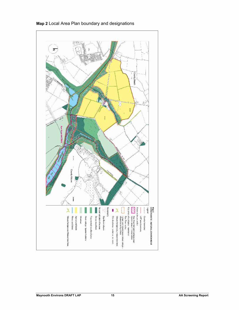
The Rye Water Valley/Carton Special Area of Conservation (SAC site code 001398) is located between Leixlip and Maynooth extending along the River Rye Water, a tributary of the River Liffey. A portion of this SAC site (some 6.1 hectares) is located in the south eastern portion of the overall LAP lands of 139 hectares, within Carton Demesne situated to the east of the RI57 at Kildare Bridge extending approximately 600m to the eastern side of Carton Bridge. This area is also a proposed Natural Heritage Area, (pNHA). The location of the Rye Water Valley/Carton Special Area of Conservation is shown on the maps in the appendices. The Rye Water Valley/Carton SAC is of importance due to the presence of several rare and threatened plant and animal species and due to the occurrence of a mineral petrifying spring (key feature/qualifying interest) considered to be rare in Europe and is a habitat listed on Annex I of the Habitats Directive. This Key feature of the SAC and associated Vertigo species are located some 4.5km downstream from the LAP boundary at Louisa Bridge adjacent to Leixlip and the Intel complex and thus outside the zone of influence of the Local Area Plan. The qualifying interests of the Rye Water/Carton SAC are located outside of the River channel (i.e. rare plant species in woodland and riparian edge). The River Rye Water is a spawning ground for Trout and Salmon, and the rare White-Clawed Crayfish, which is listed in Annex II of the EU Habitats Directive.
Figure 1 Local Context of LAP area
Maynooth Environs DRAFT LAP 6 AA Screening Report
4.0 ASSESSMENT CRITERIA Describe the elements of the project (either alone or in combination with other plans or projects) that are likely to give rise to impacts on the Natura 2000 site The underlying environmental issues of the LAP relate to the change of land use over time from agricultural/woodland to predominantly technological/commercial use (with a residential component with supporting local neighbourhood services); resulting in the creation of a predominantly campus style environment incorporating high technology land uses where none currently exists. The development of the LAP area will result in site clearance works adjacent to the River Rye water, alteration of the riparian habitat and the construction of a road bridge over the river may give rise to indirect impacts on the SAC. This process of urbanisation by its nature entails a loss of habitat (agriculture lands). However, the policies set out within the plan will provide for the protection of high amenity areas, especially the protection of the Rye Water Valley/Carton Special Area of Conservation. Describe any likely direct, indirect or secondary impacts of the project (either alone or in combination with other plans or projects) on the Natura 2000 site by virtue of:
• size and scale; • land-take; • distance from the Natura 2000 site or key features of the site; • resource requirements (water abstraction etc.); • emissions (disposal to land, water or air); • excavation requirements; • transportation requirements; • duration of construction, operation, decommissioning, etc.; • other
The overall LAP area of approximately 139 hectares consisting of green field sites comprising agricultural lands and woodland with little or no existing development. The implementation of the LAP, will give rise to intensive land use on lands that are currently agricultural in nature. The proposal to zone some 32.1 hectares of land as H2 ‘Conservation Zone’, will act as a buffer between areas identified for development and the Rye Water Valley/Carton Special Area of Conservation (SAC site code 001398), located within the south eastern portion of the LAP lands, which comprises of some 6.1 hectares. These H2 lands also include the remainder of the Rye Water Valley within the LAP area, as well as tributaries. The draft zoning map is shown on Map 3 in the Appendices. In order to achieve the vision for the area, and timely delivery of development, the approach of the LAP will be to front-load critical services infrastructure in the early stages of the development in order to achieve coherent and planned development.
The aim of this LAP is to set out a clear framework for the next six years in support of the sustainable development of the Northern Environs of Maynooth through the creation of a new dynamic area, which will integrate with the town’s urban expansion. It is envisaged that the area will be a focal point of science and technology employment, with high quality knowledge based jobs utilising the synergy with NUI Maynooth as a centre of excellence for research and innovation. In this regard it is proposed to provide for some 65 hectares of Science and Technology zoned lands (E4) within the overall LAP area. It is also proposed to provide E5 Science and Technology (small to medium scale) zoned lands of some 5.1 hectares. It is proposed to provide approximately 5.4 hectares of residentially zoned land within the LAP boundary, which would equate to approximately 180-190 no. units. A small number of units could be provided in mixed use development
Maynooth Environs DRAFT LAP 7 AA Screening Report
on the B6 zoned lands. It is envisaged that this land would be development in tandem with the Science and Technology zoned land. A further 100 no. units in the form of an ‘academic village’ will be provided for within the Carton Demesne lands as part of an integrated SMART Park, and would not be available for individual resale. It is proposed to provide a further 3.1 hectares of Neighbourhood Centre Zoned Lands (zoning objective B6), and 1.21 hectares of land identified for educational use for a potential primary school (zoning objective G1). A further 22.2 hectares of land are zoned ‘W’ – White lands, which are identified for development in the future (post 2015). The Rye Water Valley/Carton SAC will not be directly impacted by the Local Area Plan. Any Indirect impacts would be restricted to impacts on the water quality of the Rye Water including run off from construction activity relating to the SMART Park and the construction of a bridge (as part of the construction of the MOOR) which will cross a tributary of the Rye Water.
As noted above, key features (qualifying interests) of the SAC including the rare habitat petrifying spring and associated Vertigo species are located over 4.5km downstream of the proposed LAP boundary at Louisa Bridge Leixlip, adjacent to the Intel complex. Other rare plant species are woodland species or riparian species and will not be directly impacted by the development due to the H2 ‘Conservation Zone’ zoning objective. The disposal of wastewater from the LAP lands will require the agreement of Kildare County Council for connection to the network and treatment at Leixlip Wastewater Treatment Plant. Development proposals in the LAP area will be considered premature in the absence of the delivery of such primary infrastructure. Describe any likely changes to the site arising as a result of:
• Reduction of habitat area;
• Disturbance of key species;
• Habitat or species fragmentation;
• Reduction in species density; and
• Changes in key indicators of conservation value (water quality etc). The implementation of the LAP, will give rise to intensive land use on lands that are agricultural/woodland in nature. However, development will not occur within the SAC area which is designated with a H2 Conservation zone, zoning objective in the LAP. As such there will not be a direct reduction of habitat as a result of the LAP.
The clearance of the lands within the Moygaddy area (outside the SAC) and the construction of a bridge as a result of the construction of the Maynooth Outer Orbital Route over a tributary of the Rye Water, has the potential to cause temporary disturbance to otter and kingfisher that utilise the tributary river to the Rye Water river by virtue of noise and human presence. The development of the LAP lands may entail the removal of hedgerows, which contain a wide range of flora and fauna. However, the hedgerows are outside the SAC. According to the EIS submitted with the Carton Demesne planning application, the loss of habitat is the main impact of the development of the Carton Demesne lands, where it is estimated some 15-20% of the woodland area will be taken for the construction. It was considered that this impact will be locally significant and negative. In this area the woodland will be thinned down to its existing large trees and developments built on the ground in between them.
The overall populations of woodland organisms, both flora and fauna in the will be reduced by this change and a restriction of sensitive species to the remaining woodland is likely. Mammals such as red deer, badger, hare and bat species will be curtailed by

Maynooth Environs DRAFT LAP 8 AA Screening Report
the reduction in feeding area though the grey squirrel, fox and rabbit are likely to persist in numbers. The squirrel is in fact likely to increase from artificial feeding unless controlled. Deer numbers are currently controlled by shooting but there are still more of them than is good for woodland management and the establishment of young trees. The loss of cover from this project will restrict them largely to the cSAC and river valley where additional impacts on trees may be expected.
Some bird species will be restricted also by the loss of undergrowth, among them the woodcock, great tit, song thrush, blackcap and chiffchaff. The increase of traffic and people within the woodlands will cause some new disturbance to fauna and species. Smaller canopy species will not be significantly affected.
The operational phase of the scheme may have a positive impact on water quality as existing intensive agricultural land is taken out of production and nutrient loading of the river is decreased. The likely cessation of the outdoor activities on the Carton Demesne lands will be beneficial to the deer herd and other vertebrates. Describe any likely impacts on the Natura 2000 site as a whole in terms of:
• Interference with key relationships that define the structure of the site;
• Interference with key relationships that define the function of the site.
It is considered there will be no impacts that would interfere with key relationships that define the structure or function of the Rye Water Valley/Carton SAC. Describe from the above those elements of the project or plan, or combination of elements, where the above impacts are likely to be significant or where the scale or magnitude of impacts is not known. This is considered unlikely due to buffer zones proposed in LAP, which will preserve the immediate context of the Rye Water river and associated tributaries. The key qualifying element of the Rye Water Valley/Carton SAC is locates some 4.5km to the east adjoining the existing built up area of Leixlip adjacent to the Intel complex.
5.0 FINDING OF NO SIGNIFICANT EFFECTS REPORT MATRIX Name of project or plan Maynooth Environs Local Area Plan Name and Location of Natura 2000 site
Rye Water Valley/Carton SAC (SAC site code 001398) Description of the project or plan The aim of the LAP is to set out a clear framework for the next 6 years in support of the sustainable development of the Northern Environs of Maynooth through the creation of a new dynamic area, which will positively link into Maynooth town. It is envisaged that the area will be a focal point of science and technology employment, with high quality knowledge based jobs utilising the synergy with NUI Maynooth as a centre of excellence for research and innovation. The LAP is a land use plan within the terms of the Planning Acts 2000-2006 which will seek to provide guidance using policies and objectives for the development of social, physical and environmental infrastructure in a sustainable manner for the Northern Environs of Maynooth.

Maynooth Environs DRAFT LAP 9 AA Screening Report
The vision for the plan can be summarised as follows:- 1. Create a centre of excellence for Innovation and employment linked to NUI
Maynooth; 2. Protect existing natural environment and built heritage, and utilise it to frame new
development; 3. Build a distinctive and attractive mixed-use place to work and live. In land use terms sustainable development is reflected in the Draft LAP by the adoption of a range of policies and proposals which seek to:-
• Identify, protect and promote important strategically located employment lands for the Maynooth
Environs;
• Accommodate new development needs in an environmentally sensitive manner;
• Permit a wide range/mix of land uses under each zoning objective to help reduce the need to travel;
• Promote a more compact urban form in the vicinity of strategic public transport corridors and in urban centres;
• to construct the Maynooth Outer Orbital Route, and to preserve this route free from development;
• To upgrade the alignment of the R157 (including provision of 4 arm roundabout at junction with CR571);
• Promote continuity of built heritage through re-use of culturally/ historically valuable buildings;
• Conserve existing buildings and features of high environmental quality;
• Promote the use of cycling and walking and reduce reliance on private car usage;
• Ensure the protection of natural habitats, ecological resources and quality landscapes and the promotion of bio-diversity;
• Ensure the provision of high quality public water supply and drainage systems;
• Promote waste prevention, reduction, recycling and re-use;
• Support the development of a population of circa 1,500 persons over the lifetime of the Maynooth Environs LAP subject to the availability of infrastructural services;
• To consider the potential for direct vehicular and pedestrian linkage and interconnections within the LAP area, both east and west and south into the town centre of Maynooth;
• To provide for a legible and permeable road network for the area, that will encourage pedestrian/cycle use and make connections possible across the LAP area and to Maynooth Town Centre;
• To protect the existing built heritage of Moygaddy Castle, Moygaddy House and stud;
• To protect the existing built heritage of Carton Demesne and its curtilage;
• To provide, conserve and protect and enhance amenity space;
• To ensure all development in the area has no negative impact on Carton SAC pNHA or on the environmental characteristics of the area including woodland, rivers and tributaries;
• To promote a high standard of architectural design, and quality of materials utilised throughout the LAP area, that is appropriate in scale, and form to its location;
• To promote sustainability in the design of buildings;
• To support the provision of mixed use neighbourhood retail/commercial facilities, on lands within Carton Demesne and Moygaddy (Retail outlet should be of a local scale i.e., c. 300 sq m GFA);
• To ensure the provision of a high capacity broadband network in the LAP area;
• To ensure that community and social infrastructure facilities are delivered in tandem with new development in the LAP area.
The Maynooth Environs LAP will establish a vision for the orderly development of the Maynooth Environs. It will provide a framework for the development of these lands, striking a balance between providing a unique employment hub centred on a high tech/bio tech campus style environment and the amenities of future residents and also addressing the future commercial needs of the area. The envisaged objectives of the Maynooth Environs LAP will be to:-
• LAP 1 Ensure that that the area is developed in accordance with the principles of Sustainable Development.
Maynooth Environs DRAFT LAP 10 AA Screening Report
• LAP 2 Support the growth of Maynooth, which is identified in the RPGs as the anchor settlement within the overall ‘Primary Dynamic Cluster’.
• LAP 3 Promote the development of these strategic lands identified in the Meath County Development Plan as a location for significant employment.
• LAP 4 Provide a framework for the rational and coherent development of the Maynooth Environs, and ensure a coherent approach is adopted between the Maynooth Environs LAP and the County Development Plan (2007-2013) in the LAP area.
• LAP 5 Support the development of 300 residential units within the Maynooth Environs LAP area subject to the provision of adequate infrastructure. 100 units are to be delivered in accordance with the ‘SMART Park at Moygaddy Woods, Carton Demesne, Masterplan’ (2008), with a further 200 units to be provided as part of Phase 2 of development of lands in Moygaddy.
• LAP 6 Consider the potential for direct vehicular and pedestrian linkage and interconnections within the LAP area, both east and west and south into the town centre.
• LAP 7 Ensure the delivery of the Maynooth Outer Orbital Route. Provision of this route shall preferably be as part of future development proposals for the area. i.e. development driven.
• LAP 8 Provide for a legible and permeable road network for the area, that will encourage pedestrian/cycle use and make connections possible across the LAP area and to Maynooth Town Centre.
• LAP 9 Protect the existing built heritage of Moygaddy Castle, Moygaddy House and stud.
• LAP 10 Protect the existing built heritage of Carton Demesne and its curtilage.
• LAP 11 Provide, conserve, protect and enhance amenity space.
• LAP 12 Ensure all development in the area has no negative impact on Carton SAC or on the environmental characteristics of the area including woodland, rivers and tributaries.
• LAP 13 Promote a high standard of architectural design, and quality of materials utilised throughout the LAP area, that is appropriate in scale, and form to its location.
• LAP 14 Promote sustainability in the design of buildings.
• LAP 15 Support the provision of mixed use neighbourhood retail/commercial facilities, on lands within Carton Demesne and Moygaddy. The scale of a single retail outlet should be of a local scale i.e., c. 300 sq m GFA.
• LAP 16 Ensure that community and social infrastructure facilities are delivered in tandem with new development in the LAP area.
• LAP 17 Ensure the provision of adequate public water supply and drainage systems.
Is the project or plan directly connected with or necessary to the management of the site (provide details)? The LAP lands are under the ownership of two landholders. There will be no direct management of the site as a result of the LAP. Indirect management of flora and fauna may result from conditions attached to planning applications in the area. The creation of a H2 Conservation zone adjoining the Rye Water river and associated tributaries, will replace the currently high intensive managed agricultural use. The EIS submitted with the Carton Demesne application proposes a woodland management plan which should enhance the wooded area directly adjacent to the SAC.
Maynooth Environs DRAFT LAP 11 AA Screening Report
Are there other projects or plans that together with the project or plan being assessed could affect the site (provide details)? It is our understanding that Kildare County Council are preparing Local Area Plans for Maynooth Leixlip and Collinstown. Describe how the project or plan (alone or in combination) is likely to affect the Natura 2000 site.
If adequate water quality mitigation measures are not put in place to protect the Rye Water River from site clearance run off, there would be indirect effects on the SAC though changes in water quality.
In relation to lands in closest proximity to the Rye Water Valley/Carton SAC the areas of woodland to remain as they are at present, are those in the cSAC in the Rye Water valley and the north-east end of Moygaddy Wood. These areas will retain the full woodland flora. Additional planting in marginal areas as envisaged by the Woodland Management Plan will increase the number of large trees in the area and in time mitigate some of the negative impact on wildlife. According to the EIS, the likely impact on the cSAC is slight as none of the habitats or species for which it is designated will be affected and no additional disturbance is likely there. Its ecology will be more affected by the future management of the deer herd than by the proposed development.
Explain why these effects are not considered significant
The qualifying interests (key features) of the Rye Water/Carton SAC are located outside of the River channel (i.e. rare plant species in woodland and riparian edge) and a key habitat of the SAC is located 4.5 km downstream adjacent to the Intel complex (near Collinstown) and Leixlip, and thus considered to be outside the zone of influence of the proposed development. It is not considered that the proposed Draft LAP for Maynooth Environs will have any negative impacts on the conservation objectives of the Natura 2000 site as the setting, character and environmental quality of this area of high natural beauty will remain protected and free from inappropriate forms of development in the proposed LAP, through appropriate zoning objectives. Due to the emphasis of the LAP on providing a coherent framework for movement, development and linkage issues in the context of an area identified for substantial development, negative environmental effects the urbanization process are likely to be significantly mitigated through appropriate zoning designations, appropriate buffer zones and development control parameters.
List of agencies consulted
We have been advised that the following agencies were consulted at pre-draft stage in relation to the Maynooth LAP in respect of the Strategic Environmental Assessment of the Draft LAP:-
• The Environmental Protection Agency (EPA);
• The Department of the Environment, Heritage and Local Government (DoEHLG);
• The Department of Communications, Energy and Natural Resources.
Maynooth Environs DRAFT LAP 12 AA Screening Report
Response to consultation
The Department of Communications, Energy and Natural Resources made a submission on the 18th of December 2008. According to the department, the status objectives as set out in the Water Framework Directive should not be compromised as a result of the Maynooth Environs LAP. The department’s submission supported the proposed approach that development proposals in the LAP area will be considered premature in the absence of the delivery of primary infrastructure

Maynooth Environs DRAFT LAP 13 AA Screening Report
6.0 DATA COLLECTED TO CARRY OUT THE ASSESSMENT Who carried out the assessment? RPS Planning and Environment in conjunction with Meath County Council.
Sources of data Desktop study and:-
• Appropriate Assessment Screening and assessment of significant impacts on Rye Water Valley/ Carton Special Area of Conservation contained in Moygaddy Park – ‘Flora, Fauna and Fisheries Final Report’, prepared by Natura Environmental Consultants, submitted with planning application DA800091.
• Section 5.2 of EIS prepared by R. Goodwille & Associates submitted with DA801926.
Level of assessment completed
According to the Appropriate Assessment screening for the Moygaddy Park site a full ecological survey of the development site was undertaken with Desk study and background review consultation with NPWS data base. According to the methodology set out in Section 5.2 of the EIS submitted with the Carton Demesne development, the site was visited twice, in November 2006 and September 2007, and had also been investigated in Spring 2000 and previously when the original EIS for the Estate was compiled (Reg. Ref 91/441 and PL9/5/88418). It is noted in the EIS that the method corresponds to a Phase I Habitat Survey (JNCC 1991) but uses the habitat types of the Heritage Council publication (Fossitt 2000).

Maynooth Environs DRAFT LAP 14 AA Screening Report
7.0 APPENDICES Map 1 Conservation areas and national monuments.
Maynooth Environs DRAFT LAP 15 AA Screening Report
Map 2 Local Area Plan boundary and designations

Maynooth Environs DRAFT LAP 16 AA Screening Report
Map 3 Draft Maynooth Environs LAP zoning map

Maynooth Environs DRAFT LAP 17 AA Screening Report