Embed Size (px)
Citation preview
MAUNA KEA SCIENCE RESERVE MASTER PLAN
Prepared for:
The University of Hawai'i
Prepared by:
Group 70 International, Inc.
Adopted by the University of Hawai'i Board of Regents on June 16, 2000
~ ~oup 70 international • AtthilechHe • Planning • Inte<irnc De,ign • Envi<onmental Smke, • Building Diagnostics 925 Bethel Street, Fifth Floor • Honolulu, Hawaii 96813 • Phone (808) 523-5866 FAX (808) 523-5874

Mauna Kea Science Reserve Master PlanTable of Contents Page i
TABLE OF CONTENTS
MASTER PLAN ADOPTION .........................................................................................A-1
EXECUTIVE SUMMARY............................................................................................ES-1
I. INTRODUCTION.................................................................................................. I-1
II. GOALS AND OBJECTIVES ................................................................................II-1
III. METHODOLOGY ...............................................................................................III-1
IV. NATURAL ENVIRONMENT ............................................................................ IV-1
V. CULTURE ............................................................................................................V-1
VI. EDUCATION AND RESEARCH ....................................................................... VI-1
VII. RECREATION .................................................................................................. VII-1
VIII. ISSUES AND OPPORTUNITIES .....................................................................VIII-1
IX. PHYSICAL PLANNING GUIDE........................................................................ IX-1
X. MANAGEMENT PLAN .......................................................................................X-1
XI. IMPLEMENTATION PLAN............................................................................... XI-1
XII. MASTER PLAN RESPONSES TO COMMUNITY INPUT .............................. XII-1
XIII. REFERENCES..................................................................................................XIII-1

Mauna Kea Science Reserve Master PlanTable of Contents Page ii
APPENDICES(Separate volume)
A. Astronomy Research Development Plan (Institute for Astronomy, August 1999)
B. Mauna Kea Astronomy Education Center
C. Existing Astronomy Facilities
D. Mauna Kea Advisory Committee Roster
E. Glossary of Hawaiian Terms
F. Management Components of Mauna Kea Historic Preservation Plan (State of Hawaii,Department of Land and Natural Resources, Historic Preservation Division, March2000)
G. Botanical Resources, Hale Pöhaku Mid-Elevation Facilities (Char, July 1999)Botanical Resources, Mauna Kea Summit, Hawaiÿi (Char, July 1999)Mauna Kea Science Reserve Management Recommendations – Botanical Resources(Char, January 2000)
H. Mauna Kea Science Reserve Geological Resources Management Plan (J. Lockwood,Geohazards Consultants International, Inc. January 2000)
I. 1999 Mauna Kea Science Reserve and Hale Pöhaku Complex Development PlanUpdate: Oral History and Consultation Study, and Archival Literature Research.Ahupuaÿa of – Kaÿohe (Hämäkua District) and Humuÿula (Hilo District), Island ofHawaiÿi (various TMK) (Maly, February 1999)
J. An Arthropod Assessment Within Selected Areas Of The Mauna Kea Science Reserve –Final Report (Howarth, Brenner, Preston, May 7, 1999)
K. Mauna Kea Science Reserve Archaeological Site Inventory (McCoy, February 1999)Mauna Kea Science Reserve Site Descriptions – DRAFT (McCoy, 1999)
L. Mauna Kea Science Reserve Complex Development Plan Update – Roadway andUtilities Report (Sam O. Hirota, July 1999)
M. Economic Impact of Mauna Kea Observatories, Hawaiÿi County, State of Hawaiÿi (SMSResearch and Marketing, Inc., July 1999)
N. Cultural Impact Assessment Study: Native Hawaiian Cultural Practices, Features,and Beliefs Associated with the University of Hawaiÿi Mauna Kea Science ReserveMaster Plan Project Area (PHRI, Inc., August 1999)

Mauna Kea Science Reserve Master PlanTable of Contents Page iii
O. Voices and Visions of Mauna Kea: Educational Circular (The Johnson Strategy Group,Inc. March 2000)
LIST OF FIGURES
I-1 Island of Hawaiÿi ................................................................................................. I-2I-2 Mauna Kea Science Reserve ................................................................................ I-3
IV-1 Summit Flora Examples ................................................................................... IV-3IV-2 Summit Fauna Examples .................................................................................. IV-5IV-3 Mid-Elevation Flora and Fauna Examples ........................................................ IV-7
V-1 Ahupuaÿa of Kaÿohe ...........................................................................................V-3V-2 Archaeological Site Examples ............................................................................V-5V-3 Archaeology Sites Map – Science Reserve..........................................................V-6V-4 Annotated Interview Map (Kepä Maly, 1999) ......................................V-10 & V-11V-5 Landscape.........................................................................................................V-14V-6 Natural Area Reserve (Adze Quarry, Waiÿau) ...................................................V-16
VI-1 Evolution of Facility Development ................................................................... VI-3VI-2 Astronomy Facilities ........................................................................................ VI-6
VII-1 DLNR Hunting Units ...................................................................................... VII-4
VIII-1 Land Ownership Map .....................................................................................VIII-2VIII-2 1977 Mauna Kea Plan Management Areas ......................................................VIII-4VIII-3 Analysis Areas for Telescope Siting (1983) ....................................................VIII-6VIII-4 Snow & Snow Removal ...............................................................................VIII-16
IX-1 Puÿu Poliÿahu and Lunar and Planetary Laboratory Test Station........................ IX-5IX-2 Undeveloped Puÿu ............................................................................................ IX-6IX-3 Cultural Landscape Map................................................................................... IX-7IX-4 Existing Trail Linking Hawaiian Cultural Resources......................................... IX-9IX-5 Simulated Views from Waiÿau........................................................................ IX-10IX-6 Geology.......................................................................................................... IX-11IX-7 Slope Analysis................................................................................................ IX-12IX-8 Summit Flora Habitat ..................................................................................... IX-13IX-9 Potential Wëkiu Habitat.................................................................................. IX-15IX-10 Natural Resource Composite........................................................................... IX-16IX-11 Archaeology Sites Map................................................................................... IX-17IX-12 Natural and Cultural Resources Composite..................................................... IX-19IX-13 Astronomy Precinct ........................................................................................ IX-21IX-14 Telescope Siting Areas (1983) ........................................................................ IX-24IX-15 Telescope Siting Areas (2000-2020) ............................................................... IX-25IX-16 Physical Plan and Proposed Astronomy Facilities ........................................... IX-28IX-17 Existing and Redeveloped Summit Ridge Telescopes ..................................... IX-30IX-18 W.M. Keck Observatory with Proposed Outrigger Telescopes ........................ IX-32IX-19 Proposed Submillimeter Array Expansion....................................................... IX-34
Mauna Kea Science Reserve Master PlanTable of Contents Page iv
IX-20 Proposed Conventional Optical/Infrared Telescope......................................... IX-36IX-21 Proposed Next Generation Large Telescope (NGLT) ...................................... IX-38IX-22 Views from Hilo............................................................................................. IX-41IX-23 Views from Honokaÿa..................................................................................... IX-42IX-24 Views from Waimea....................................................................................... IX-43IX-25 Existing Ski Areas .......................................................................................... IX-48IX-26 Mauna Kea Science Reserve Physical Plan ..................................................... IX-50IX-27 Hale Pöhaku Plan ........................................................................................... IX-52
X-1 Office of Mauna Kea Management Position in UH System.................................X-4X-2 Organization Chart .............................................................................................X-6
XI-1 Management Plan Implementation Milestones .................................................. XI-2XI-2 Project Approval and Design Review Procedures.............................................. XI-8XI-3 General Master Plan Amendment Procedures for Science Reserve .................. XI-16
LIST OF TABLES
VIII-1 Mauna Kea Responsibility Matrix Existing Authority ....................................VIII-10IX-1 Existing and Proposed Observatories at Mauna Kea Science Reserve ............... IX-45XI-1 Responses to Auditor’s Recommendations....................................................... XI-24

Mauna Kea Science Reserve Master PlanMaster Plan Adoption Page A - 1
MASTER PLAN ADOPTION
On June 16, 2000, the University of Hawaiÿi Board of Regents adopted the followingdocument, the Mauna Kea Science Reserve Master Plan, as the policy framework for theresponsible stewardship and use of University-managed lands on Mauna Kea through theyear 2020. At the same time, the Regents called for the immediate establishment of theOffice of Mauna Kea Management, the Mauna Kea Management Board, and the KahuKüpuna Council, as the first steps in the implementation process.

MAUNA KEA SCIENCE RESERVE MASTER PLAN
EXECUTIVE SUMMARY

Mauna Kea Science Reserve Master PlanExecutive Summary Page ES - 1
EXECUTIVE SUMMARY
The Mauna Kea Science Reserve is an 11,288 acre area of land leased by the Universityof Hawaiÿi from the State of Hawaiÿi for use as a scientific complex. Facilitydevelopment in the Science Reserve has focussed predominantly on the summit areaabove 13,200 feet. Support facilities have been developed at Hale Pöhaku (elevation9,200 feet) outside the Science Reserve. The Reserve was established in 1968 when theBoard of Land and Natural Resources approved a 65 year lease (Lease No. S-4191). Twoparcels in the summit region excluded from the Science Reserve belong to the MaunaKea Ice Age Natural Area Reserve (NAR).
The University of Hawaiÿi adopted the Mauna Kea Science Reserve ComplexDevelopment Plan (CDP) in 1983 which has guided development up to the present time.The CDP projected development up to the year 2000 and has been largely implemented.The 1983 Plan and the State of Hawaiÿi’s efforts to develop astronomy as an academicdiscipline and an industry have been largely successful. Today, Mauna Kea is known asthe premier location for astronomy in the Northern hemisphere and has a significantpositive economic impact on the State of Hawaiÿi and the Big Island. This report is anupdate of the 1983 Plan and extends the planning horizon to the year 2020.
The Plan also addresses issues and concerns that have arisen in 30 years of developmenton the mountain. It specifically addresses comments and recommendations included inthe 1998 Legislative Auditor’s report on the management of Mauna Kea. The Planintegrates future uses (education, research, culture and recreation) with a deeperawareness of the natural and cultural resources and significance of Mauna Kea. Inparticular, the Plan lays the groundwork for implementation of educational outreach tothe native Hawaiian community at primary, secondary, and post-secondary levels. Newethnographic, archaeological and biological studies of the mountain have expandedknowledge and increased sensitivity to the special qualities that make Mauna Kea aunique place on the planet.
The Master Plan report is structured in three parts. The first section lays out the directionand methodology of the Plan. The second section identifies the major components of thePlan. This section presents existing conditions and the historical background of thesecomponents. It also includes a chapter on issues and opportunities. The third sectionintegrates these components into physical and management plans which make up theMaster Plan. The physical and management plans represent a major change in theallocation of use areas and management structure.
New Management Organization: To implement this Plan a new management structurewith a single point of contact located on the Island of Hawaiÿi is recommended. Thisorganization would be an operational unit within the administrative purview of the Officeof the Chancellor at UH Hilo. The organization would have a director, administrativestaff, rangers and maintenance personnel. Additionally, it would serve as the nerve

Mauna Kea Science Reserve Master PlanExecutive Summary Page ES - 2
center for volunteers and organizations affiliated with Mauna Kea. This single point ofcontact, given comprehensive management authority located in Hilo and on themountain, would integrate management responsibilities to protect the sustainability ofMauna Kea’s resources. It would coordinate interagency issues and be a conduit to thecommunity. The continuous presence of rangers on the mountain at all times is expectedto vastly improve stewardship of Mauna Kea. Being an operational unit of UH Hiloemphasizes the permanence of the organization and the University’s commitment to itsoperations.
Community Involvement: The Plan recommends that the University appoint a MaunaKea Management Board to provide the community with a direct voice into themanagement of the mountain. Additionally, a Kahu Kupüna Council is recommended toprovide advice and direction on native Hawaiian cultural issues. Establishment of aprofessional Design Review Committee is also recommended. This Committee wouldreview all project proposals to ensure that project plans conform to the design guidelinesand intents of the Master Plan. Additionally, a docent program and other volunteerprograms coordinated by the new management organization would provide nearlyconstant, intimate community involvement in the care of the mountain. Community inputduring the Master Plan process is addressed in Section XII.
Management Policy Guidelines: The Plan recommends management policy guidelinesthat may be further developed and adopted by the new management organization. Hoursof operation and the possible development of a shuttle service are proposed for safety andresource protection. Recommendations are also made concerning the support facilities atHale Pöhaku and the summit and concerning safety and security procedures. Publicaccess would remain open but may be managed through registration as needed for safetyor resource protection purposes. All existing uses such as snow playing, skiing andhunting will be permitted. Hunting usually occurs in the lower elevations. Parking areaswould be increased incrementally at Hale Pöhaku, and near the summit “Poi Bowl” areaas demand increases. There would be no restrictions on religious worship.
Physical Planning Guide: The Physical Planning Guide consists of four majorcomponents: natural resources, culture, education and research, and recreation. Theexisting 11,288-acre Science Reserve would be divided into two areas under the newPlan. The great majority of the Science Reserve (95%) will become a 10,760-acreNatural/Cultural Preservation Area, with no development activity. The remaining 525acres (5%) are designated as an Astronomy Precinct, thereby greatly reducing the areapreviously available for astronomy development. The 525-acre area would be subject toarchitectural, environmental, and cultural controls. All currently undeveloped summitpuÿu (hills or cinder cones) would remain undeveloped. Support facilities at Hale Pöhakuwould be expanded incrementally as needed, and existing construction cabins willbecome available for public use. Management and expansion of the facilities at HalePöhaku would accommodate other educational and research programs as well as culturaland recreational uses that are compatible with ongoing operations. A common databasecontaining information about all the major components is recommended to facilitatemanagement efforts and integrate policies.
Mauna Kea Science Reserve Master PlanExecutive Summary Page ES - 3
The Physical Planning Guide directs future development on the mountain in three ways.First, the Plan consists of plans, maps, geographic information system (GIS), and criteria,which promote the sustainable use, enhancement and development of the Mauna KeaScience Reserve. Second, design guidelines and project review procedures guidephysical development through assessments of site location, size, mass, color and otherphysical attributes. Third, it identifies an Astronomy Precinct which contains astronomydevelopment within and near existing developments and creates a natural/culturalpreservation area for the remainder of the Science Reserve. The following highlightssome of the important concepts associated with each component area:
Natural Resources: Natural resources are protected in the following way:• Identification and GIS mapping of resources.• The bulk of the Science Reserve (10,760 acres) is designated as a natural and cultural
preservation area.• Future facilities will be designed and sited to avoid and minimize impacts to sensitive
habitat and rare or fragile geological features. Additionally, development approvalswould contain conditions for the protection of natural resources.
• Registration procedures and signage plans would be geared to educate visitors aboutthe value and fragility of these resources.
• Volunteer groups would be encouraged to adopt the mountain and support activitiesthat sustain the mountain.
Archaeology and Culture: The cultural resources component includes the following:• GIS mapping of known features.• Designation of 10,760 acres as a Natural and Cultural Preservation Area. This
designation highlights the cultural values of Mauna Kea.• The importance of geo-physical forms such as Puÿu Poliÿahu, Puÿu Lïlïnoe, other
summit puÿu and Waiÿau is recognized and protected in the Plan. All undevelopedpuÿu are preserved.
• A view corridor to the west is preserved based on a common cultural practice with apotential for future interpretation.
• Modern cultural practitioners would have unrestricted access.• The formation of a Kahu Kupüna Council to provide advice and facilitation in
cultural matters is recommended.• Photographic monitoring of historic sites is suggested.• Registration procedures, signage and docent programs are recommended to educate
the public on the value of cultural resources and the appropriate protocol formovement in sensitive areas.
• Special development protocols are recommended to avoid inadvertent impacts oncultural properties.
• Management practices would be coordinated with the State Historic PreservationOffice.

Mauna Kea Science Reserve Master PlanExecutive Summary Page ES - 4
Education and Research: The education and research component includes the followingproposed actions and developments:• Recycling of up to five of the existing observatory sites with renovations or newer
Optical/Infrared facilities. Five potential recycle sites are identified.• Expansion of the Keck facility to include 4 to 6 outrigger telescopes within the
existing Keck site and no higher than 1/3 the height of the existing Keck telescopes.• Expansion of the Submillimeter Array to include up to 24 new pads and 12 new
antennas in addition to the 12 currently permitted antennas.• One additional site for a new conventional Optical/IR instrument on the north plateau.• Site for a Next Generation Large Telescope with a mirror 25 to 50 meters in diameter.• Expanded educational outreach, with particular emphasis on native Hawaiians.• A UH Hilo instructional telescope and site to replace the existing cinderblock
building located between the UKIRT and UH 24-inch telescopes. The telescope isdesignated for use in teaching and training students. Besides basic undergraduateeducation, this facility would facilitate training for jobs in astronomy.
• The total economic impact of the mountain’s existing observatories in the State isestimated at $142 million annually. This includes employment and expendituresdirectly related to telescope operations as well as the indirect impact of purchasesmade by astronomy-related firms and employees. Construction expenditures in theCounty of Hawaiÿi have totaled approximately $207 million to date.
• Other academic disciplines and programs are specifically encouraged to view themountain as an outdoor classroom and laboratory. These efforts would be supportedat Hale Pöhaku and the summit area.
• Joint use of existing facilities/new support facilities at Hale Pöhaku.• Docent programs in broad areas of natural, cultural and educational areas within the
management plan.• Special educational and cultural events at Hale Pöhaku.
Recreation: Recreational opportunities are protected and supported as follows:• A public recreational shelter and comfort station is included for visitors, spectators
and recreationalists in the Astronomy Precinct summit snow area.• Recreational activities that are currently allowed will continue to be permitted.
This document, the UH Mauna Kea Science Reserve Master Plan, provides the policyframework for the responsible stewardship and use of University-managed lands onMauna Kea through the year 2020. It proposes several significant land use andmanagement structural changes based on a new paradigm of the University’s leased landsas a natural and Hawaiian cultural reserve in addition to being a Science Reserve. Thisframework represents a vision which will require conscientious implementation anddevelopment over the years to realize, yet one which promises the achievement of statedgoals and objectives of the Master Plan. As these goals and objectives are realized, it ishoped that Mauna Kea will increase in its meaning and value to many individuals andgroups in the community who see it as a unique treasure worthy of our respect and care.

MAUNA KEA SCIENCE RESERVE MASTER PLAN
I. INTRODUCTION

Mauna Kea Science Reserve Master PlanIntroduction Page I - 1
INTRODUCTION
The ancient saying “Mauna Kea kuahiwi ku ha‘o i ka mälie” (Mauna Kea is theastonishing mountain that stands in the calm) (Pukui 1983: No. 2147), expresses theuniversal feeling experienced by all who come in contact with this special place.Standing tall over the Island of Hawaiÿi, Mauna Kea is home to vast physical, natural andcultural resources (Figure I-1). From early adze makers to modern day astronomers,Mauna Kea has long been a special place for work, worship, and reflection. For nativeHawaiians, both ancient and modern, the feelings for Mauna Kea go beyond wonder andastonishment, to the recognition of the mountain as a sacred domain. These profoundfeelings of reverence are expressed in the saying: “O Mauna Kea ko käkou kuahiwi laÿa”(Mauna Kea, our sacred mountain). As with other ethnic cultures throughout the world,early Polynesians believed their highest points of land were the most sacred; and MaunaKea having the highest mountain top in all of Pacific Polynesia, was considered the mostsacred place of all. Standing tall over the island if Hawaiÿi, Mauna Kea was host to earlyHawaiÿian traditions which included religious practices, study of the heavens, and toolmaking in the Keanakäkoÿi adze quarry.
For many years hikers, hunters, scientists, worshippers, and skiers have come to thehighest mountain in the Pacific Basin. In the past three decades the Mauna Kea ScienceReserve has evolved into the world’s premier astronomy complex. Mauna Kea’sobservatories are known worldwide for their advanced technologies, excellent viewingenvironment, and the discoveries that have been made with these facilities. Thedevelopment of this complex has not come without its costs. The roadway that wasinstalled for the testing and construction of the first telescopes has opened the mountainto all. Physical development, foot and vehicular traffic, and the byproducts of man’s useof the mountain have all left temporary and permanent impacts on the mountain. Morepositively, the access has provided a wealth of information and enjoyment for those whohave taken interest in this great mountain.
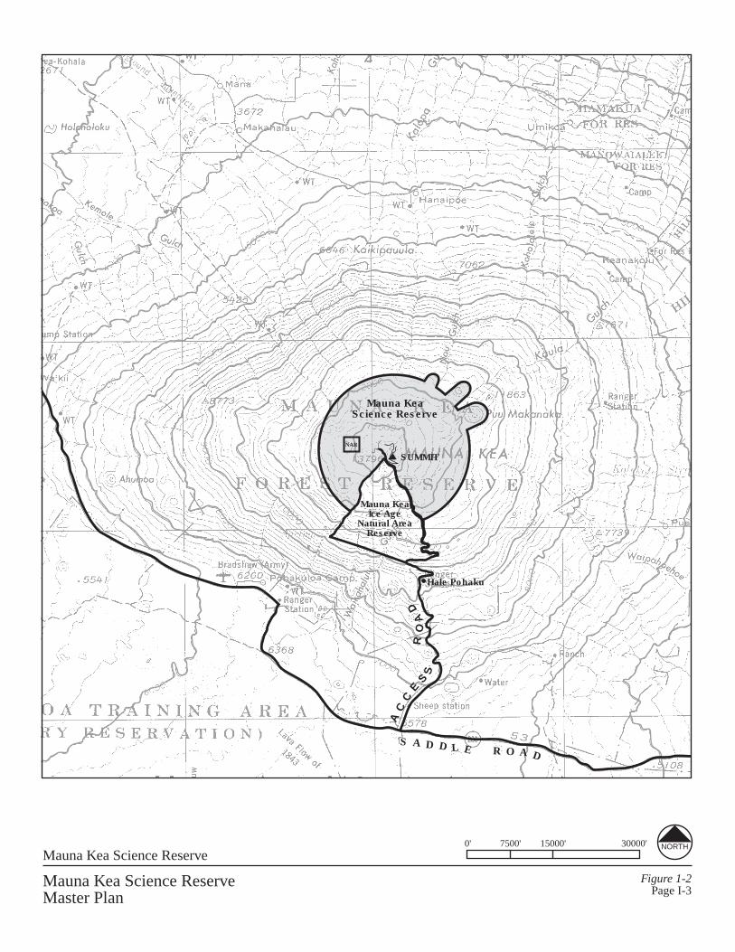
The Science Reserve is a 11,288 acre area of land that is leased by the University ofHawaiÿi from the State of Hawaiÿi for use as a scientific complex (Figure I-2). Theastronomy complex is centered near the middle of the summit plateau while theremainder of the Science Reserve serves as a buffer area. The Science Reserve is acircular area (2.5 miles in radius) centered on the Mauna Kea summit -- approximatelythose lands above the 12,000 foot elevation -- except for those areas that are part of theMauna Kea Ice Age Natural Area Reserve.
Tomorrow, when we are gone, man will continue to look to his ancestors for wisdom andguidance, seek knowledge and joy in his physical world, and look to the stars andelsewhere to answer universal questions. Given the changes that Mauna Kea hasexperienced over time, we must ask ourselves what the mountain will be like in thefuture. Will this cultural treasure be well cared for and preserved? Will it be moreaccessible to hikers, cultural practitioners, scientists, students, and skiers? Will its natural

Mauna Kea Science ReserveMaster Plan
Figure I-1Page I-2
Island of Hawaiÿi No Scale
KE-AHOLE
i I
/ HAMAKUA
MAUNAKEA_; I
KA LAE (South Point)
I I • -✓-
✓-- - 1 / / (
i
AC
CE
SS
RO
AD
S A D D L E R O A D
SUMMITNAR
Mauna KeaScience Reserve
Hale Pohaku
Mauna KeaIce Age
Natural AreaReserve
Mauna Kea Science ReserveMaster Plan
Figure 1-2Page I-3
Mauna Kea Science Reserve0' 7500' 15000' 30000' NORTH
/ ' ,-~:', u<V0( . \
'\._ ,/ .-· .
r I '1 ,.,, ; ~.
' '
·'-. \ '. \ --~> · ',, ' \ '\
' : ,✓ I
i / ::: / C"-:
_) "'. ·
Mauna Kea Science Reserve Master PlanIntroduction Page I - 4
resources be in better condition than they are today? Will native Hawaiians again playleading roles in discoveries and way finding for humanity? The answers will rest in thehands of those who accept the responsibility of stewardship entrusted to them.
The Mauna Kea Science Reserve Master Plan is an update and extension of the 1983Mauna Kea Science Reserve Complex Development Plan. The 1983 Plan provided aphysical plan for astronomy development to the year 2000 and presented a managementplan and implementation strategy for managing and monitoring the various uses of themountain. The purpose of this Plan update is to develop physical and management plansto guide the use of and facility development within the Mauna Kea Science Reserve,Summit Access Road, and Hale Pöhaku, for the next twenty years.
The 1983 Plan has largely been implemented in terms of the astronomy facilities thathave been built or are under construction and the improvements that have been made tothe infrastructure and mid-elevation facilities. This planning effort extends the physicalplanning for the mountain another 20 years and more fully integrates non-astronomyresources and uses. The management plan offers an organizational solution and policyguidance to address some of the use conflicts, maintenance, and access issues that existtoday. The Master Plan assumes that the Mauna Kea Science Reserve will continue, andeven grow, in importance to scientists, educators, naturalists, and recreational users in theyears to come.
The Master Plan report is structured in three parts. The first section includes theintroduction, goals and objectives, and methodology, which establish the direction andprocess for the Plan. The second section details the components that make up thephysical environment and human use of Mauna Kea. The relationships among thesecomponents – the natural environment, culture, education and research, and recreation –are analyzed and integrated into future plans in the third section of the Master Plan. Thephysical and management plans which make up the Master Plan propose facilities,supporting infrastructure, preservation areas, and a management structure and policies toguide the future of uses within the Science Reserve.
This approach to the Master Plan is based on the principles of integrated cultural andnatural resources management planning. This Plan appreciates and respects the inter-relationships of all facets of the natural systems and cultural context of the site andprovides a framework for sustainable development on the mountain. The Plan valuespreservation and interpretation of indigenous natural and cultural resources and theuniqueness of these resources on Mauna Kea. The proposed Plan, in its simplest sense,attempts to balance economic and scientific prosperity, social equity, cultural values, andenvironmental integrity.
MAUNA KEA SCIENCE RESERVE MASTER PLAN
II. GOALS AND OBJECTIVES

Mauna Kea Science Reserve Master PlanGoals and Objectives Page II - 1
GOALS AND OBJECTIVES
The following goals and objectives were established to guide the preparation of theMaster Plan.
Update the 1983 Mauna Kea Science Reserve Complex Development Plan by:
1) Developing a vision for the sustainable use and enhancement of the Mauna KeaScience Reserve as a Hawaiian place with significant and unique cultural, natural,educational/ research and recreational values, meanings and potentials, both locallyand globally.
2) Integrate and balance cultural, natural, education/research and recreational values anduses in a physical and management plan which will remedy existing problems andprovide a framework and structure for the responsible and sustainable stewardship ofthe Mauna Kea Science Reserve.
These goals have been carried throughout the master planning process from theintegration of data to the formulation of physical plans and a proposed managementstructure. The goals of sustainability and integration should continue to guide the futuredecision making for Mauna Kea through and beyond the implementation of this plan.
A. Cultural Objectives
1) Promote a greater knowledge base and understanding of cultural resources, Hawaiiancultural practices, and significance of archaeological sites, place names, andgeophysical elements (such as cinder cones, glacial deposits, etc.), through theplanning process.
2) Preserve and manage cultural resources in a sustainable manner so that futuregenerations may share in the understanding and knowledge of the mountain’sarchaeological and cultural sites.
3) Protect the opportunities for individuals and groups to engage in cultural practices.
4) Define areas, criteria and support facilities for cultural resources and practices, asapplicable, to allow for sustainable, integrated planning and management.
5) Preserve the cultural landscape to enhance meaning, relationships, and resources formodern appreciation, research, and practice.
The cultural objectives recognize that Mauna Kea, the highest point in Pacific Polynesia,is a revered resource and the site of Hawaiian cultural practice today. This plan

Mauna Kea Science Reserve Master PlanGoals and Objectives Page II - 2
encourages preservation of cultural resources and at the same time supports use andfurther understanding of the mountain’s resources by practitioners and others.
B. Natural Resources Objectives
1) Promote a greater knowledge base focused on the most critical natural resources toinclude flora, fauna, and natural landforms, through the planning process.
2) Protect and preserve, through planning and management, unique geological featuresand biological communities, recognizing the symbiotic relationship between the twoin the Science Reserve.
3) Use natural resource areas for recreation in a manner that both protects the resourcesand promotes the safety of individuals.
4) Allow for current and future use of natural resources for educational programs andHawaiian cultural practices for the community, schools and universities, and visitors.
5) Protect the mountain’s natural landscape to preserve its cultural and scenic values.
6) Define specific areas and criteria for natural resource use as applicable, to allow forsustainable, integrated planning and management.
As in the case of cultural resources, the Master Plan encourages greater understanding,appropriate use, and preservation of the mountain’s natural resources. The Master Planobjectives call for the integration of natural resources with cultural resources and use,education and research, and recreation components.
C. Education/Research Objectives
1) Expand knowledge of the Science Reserve as an educational resource for the benefitof the community, including native Hawaiians, students, researchers, and visitors,through the planning process.
2) Protect natural and cultural resources and insure managed access to the ScienceReserve for education and research use.
3) Protect and enhance astronomy research at Mauna Kea as the premier observatory sitein the Northern Hemisphere.
4) Define areas, criteria and support facilities for education and research as applicable,to allow for sustainable, integrated planning and management.
Mauna Kea Science Reserve Master PlanGoals and Objectives Page II - 3
The education and research objectives recognize the importance of astronomy activity atMauna Kea and encourage appropriate use of the mountain for further education andresearch use in other fields to include science and cultural fields.
D. Recreational Objectives
1) Expand understanding of recreational uses and potentials of the Science Reserve.
2) Retain and enhance recreational opportunities within the Science Reserve, whileprotecting natural resources, cultural resources, and cultural practices.
3) Define areas, criteria and support facilities for recreational uses, sightseeing andcommercial tours, as applicable, to allow for sustainable, integrated planning andmanagement.
The above objectives encourage mixed use of Mauna Kea in an organized setting andwith the primary importance given to the preservation of the resources of the mountain.Recreational activities are guided in a direction that promotes safety and practices thatrespect the mountain’s natural and cultural values.
E. Physical Plan Objectives
1) Create physical plans, maps, and criteria which promote the sustainable use,enhancement and development of resources of the Science Reserve in order to:
• Protect historic/cultural resources and practices: e.g. archaeology sites, Hawaiiancultural practices
• Protect natural resources: e.g. Wëkiu habitat, alpine ecosystem• Protect and enhance education and research: e.g. astronomy, ecology, geology• Protect and enhance recreational opportunities: e.g. hiking, skiing
2) Analyze and depict physical implications of uses over time; address and mitigatevisual and environmental impacts.
3) Guide future physical development, not only locationally, but with respect tocharacter, size, mass, color and other physical attributes.
4) Define infrastructure and elements to support goals regarding natural resources,culture, education/research, and recreation.
These objectives are further detailed in the Physical Planning Guide (Section IX).

Mauna Kea Science Reserve Master PlanGoals and Objectives Page II - 4
F. Management Plan Objectives
1) Create a funded structure for sustainable, focused management of resources andoperations of the Mauna Kea Science Reserve in order to:
• Protect historic/cultural resources: e.g. archaeology sites, Hawaiian culturalpractices
• Protect natural resources: e.g. Wëkiu habitat, alpine ecosystem• Protect and enhance education and research: e.g. astronomy, ecology, geology,
Hawaiian culture and archaeology• Protect and enhance recreational opportunities: e.g. hiking, snow play, skiing• Promote public safety
2) Create a funded structure which meets the following objectives:
• Promotes community input.• Establishes local management.• Establishes a focal point for management responsibility.• Establishes clear lines of decision making and accountability.• Is economically and structurally feasible.• Provides a base for future expansion of the scope of activities in the Science
Reserve.
These objectives are further detailed in the physical and management plan sections(Sections IX and X).
MAUNA KEA SCIENCE RESERVE MASTER PLAN
III. METHODOLOGY

Mauna Kea Science Reserve Master PlanMethodology Page III - 1
METHODOLOGY
During the preparation of the 1983 plan, studies were undertaken which were the first oftheir kind on Mauna Kea and which provided valuable scientific, archaeological, andethnographic information. Follow-up work and additional studies have beenaccomplished in the preparation of this Master Plan as follows:
Dr. Francis Howarth of the Bishop Museum and colleague Greg Brenner have conductedfield work and analysis updating arthropod studies done in the 1980s. During the earlierwork, Howarth and his team identified numerous arthropods including the Wëkiu bug,which exists only on Mauna Kea and which had not been discovered previously.Recently, Howarth and Brenner tested the bug’s population distribution, assessedseasonal trends, and expanded on their understanding of the bug. Their surveys alsoincluded other endemic and introduced species.
Archaeologist Patrick McCoy has worked on Mauna Kea for over two decades studyingsites in the Mauna Kea Science Reserve and in the Mauna Kea Ice Age Natural AreaReserve. A total of 93 archaeological sites have been identified in surveys encompassingsome 3000 acres of land in the Science Reserve (McCoy, 1999). McCoy and HollyMcEldowney, both with the State Historic Preservation Division, have prepared anhistoric preservation management plan for Mauna Kea. The plan identifies and assessesthe archaeological sites that have been found in the Science Reserve and suggestguidelines for the future management of the sites and the broader summit plateau.
Cultural specialist Kepä Maly has conducted oral history interviews and archival researchto “document some of the traditions and practices associated with Mauna Kea, and toidentify some of the significant features of the landscape, including natural and man-made cultural resources on Mauna Kea so that they can be protected, preserved, andappropriately managed in the future” (Maly, 1999).
In addition to Maly’s work for this Plan, he conducted earlier archival research of theHumuÿula and Kaÿohe ahupuaÿa for the Native Lands Institute (Maly, 1998). Othercultural specialists have also conducted ethnographic research that is valuable to thiseffort. Edward and Pualani Kanahele (1997), and Charles Langlas (1997) conductedstudies in association with the Saddle Road Improvement project. Their work providesimportant information and adds to the greater understanding of Mauna Kea as a culturalplace.
The ongoing studies of the natural and cultural resources of Mauna Kea provide soundinformation that can be used for physical planning and management policy decision-making. In preparing this plan, recent and historical data were compiled in a GeographicInformation System (GIS). Information on slope, Wëkiu bug habitat, flora,archaeological sites, cultural landscape features, roads, and astronomy facilities werelayered together and analyzed in relationship to one another. These components are

Mauna Kea Science Reserve Master PlanMethodology Page III - 2
described in Sections IV through VII and analyzed in Section IX. By looking at theinformation in an integrated way, areas that must be protected and areas that can be usedfor educational and recreational uses and facilities, including new astronomy facilities,are identified. The physical and management plans included in this Master Planrecommend the continued integration of knowledge, resources, uses and managementpractices.
In addition to expert research, this planning process incorporates broad community input.In the Spring of 1998, University of Hawaiÿi president Kenneth Mortimer invited twenty-four individuals to serve on the Mauna Kea Advisory Committee to “help the Universityof Hawaiÿi as it plans for future facilities development on the mountain and strives toimprove its management of the Science Reserve and the Visitors’ Station at HalePöhaku.” (Mortimer, May 8, 1998) Committee members represented variousorganizations including the University of Hawaiÿi at Hilo, the UH Institute forAstronomy, environmental groups, the business community, native Hawaiianorganizations, state agencies, county government, and the broader Hawaiÿi community.In his invitation to the individual committee members the President stated that “Thepurpose of the Mauna Kea Advisory Committee in its broadest terms is to provide neededinput to the University of Hawaiÿi and the people of the State of Hawaiÿi regarding theconditions under which future development should occur on Mauna Kea” (Mortimer,May 8, 1998).
This Committee met regularly from June, 1998 to August, 1999 to discuss existingconditions, management issues, and the future uses and management of Mauna Kea. TheCommittee invited various experts to their meetings and conducted an initial round ofpublic meetings to gather the opinions and suggestions of the broader Hawaiÿi Islandcommunity. Public meetings were held in the communities of Waimea, Kona, and Hiloon August 31, September 1, and September 3, 1998, respectively. Approximately 50individuals attended the Waimea meeting, 15 attended the Kona meeting, and 100attended the meeting in Hilo (all numbers are estimates). A variety of views wereexpressed during these meetings. Some individuals expressed the need for bettermanagement of the mountain’s resources. Some felt that no more astronomy facilitiesshould be developed on the Mauna Kea summit plateau. Others expressed anappreciation for the scientific and economic benefits provided by the astronomy industryand a desire for astronomy to continue and expand.
During Advisory Committee meetings, several members presented specific proposals,representing their views or the views of organizations they represent. Committeemembers reviewed and discussed proposals before providing recommendations.
The Committee conducted a second series of public meetings during which specificphysical and management proposals were presented to the community. As in the firstseries of public meetings, these were held in Waimea, Kona, and Hilo on May 24, 25, and27, 1999, respectively. During these meetings a slide presentation was given by Group70 International, Inc. The presentation reviewed the natural, cultural, recreational andeducational resources of the mountain and introduced the master plan, with proposed

Mauna Kea Science Reserve Master PlanMethodology Page III - 3
facilities and management structure. Community members were asked to share theirreactions and proposals for the mountain. Based on their own deliberations and thefeedback received from the community, the Mauna Kea Advisory Committee formulatedand forwarded their recommendations to the University President. In addition to theinformation shared in Committee meetings and public meetings, Group 70 also met withother community members, groups, and experts to discuss possible recommendations forthe physical and management plans. Among those contacted were representatives of theastronomy community nationwide, the National Park Service, the Department of Landand Natural Resources, the UH Administration, the Department of Hawaiian HomeLands, and representatives of various Hawaiÿi Island organizations such as the ILWU,Chambers of Commerce, and local school administrations. This report, while a productof Group 70 International which is responsible for any errors, therefore incorporates therecommendations of the Mauna Kea Advisory Committee, and the input of many otherstakeholders.
An Environmental Impact Statement (EIS) has been prepared for this Master Plan inaccordance with Hawaiÿi Revised Statutes, Chapter 343. During the public reviewprocess, the comments received from the public and from governmental agencies wereassessed and responses incorporated into the revised Master Plan report. The Final EISwas accepted by the Governor on February 2, 2000. The University of Hawaiÿi Board ofRegents adopted the Mauna Kea Science Reserve Master Plan in June 2000.

Mauna Kea Science Reserve Master PlanMethodology Page III - 4
PLANNING COMPONENTSBACKGROUND SECTIONS
Natural EnvironmentCultureEducation and ResearchRecreationIssues and Opportunities
In Hawaiÿi and elsewhere, those who know of Mauna Kea have a personal sense of themountain and its resources. While each has their own experience and perception, there isa wealth of historical and scientific knowledge available for sharing and for use inplanning for the future of the mountain.
The following sections explore the use and resource components that combine to createthe unique history, landscape and activities of Mauna Kea. The natural environment –the puÿu, glacial remains, atmospheric qualities, and views - and cultural resources –landscape and archaeological sites - of Mauna Kea shape much of today’s use of themountain. Because of the unique natural and cultural qualities of the mountain, its slopesand summit plateau are used by a variety of individuals and organizations for culturalpractice, education, research, and recreation.
Natural environment, culture, education and research, and recreation components arepresented in the following sections. Previous studies are reviewed and on-going researchis discussed. Current uses are explored as are the potentials for new uses in the future.The use and management of these components, and their relationships with each othercreate both issues that must be addressed and opportunities that may be explored. Theseissues and opportunities are also discussed.
Taken as a whole, these sections provide the basis for the development of the physicaland management plans that follow. Many of the Master Plan’s recommendations arebased on the research and issues explored here.

MAUNA KEA SCIENCE RESERVE MASTER PLAN
IV. NATURAL ENVIRONMENT

Mauna Kea Science Reserve Master Plan
Natural Environment Page IV - 1
NATURAL ENVIRONMENT
Geologic History
The Hawaiian Archipelago, extending 2,200 miles across the Pacific Ocean, was builtalmost entirely by volcanic activity. The oldest of the volcanoes are in the northwest andthe youngest extend to the southeast. Each island is the top of an enormous volcano thatgrew from the seafloor to above sealevel, modified by stream and wave erosion and byminor amounts of organic reef growth.
Mauna Kea formed as a shield volcano that was later modified by neatly formed cindercones and associated blocky lava flows. It is a dormant postshield stage volcano that lasterupted about 4,500 years ago; and hence cannot yet be labeled as extinct. The oldestexposed lava flows on Mauna Kea are approximately 250,000 years old. The mountain’slatest volcanic activity was characterized by explosive eruptions that producedwidespread ash deposits. (Clague in Atlas of Hawaii , 1998).
The dome of Mauna Kea measures 30 miles across and is studded with cinder cones in apattern indicating that the volcano was built over rifts extending eastward, southward,and westward. The volcanic rocks of Mauna Kea are divided into two series. The olderHamakua series is made up chiefly of primitive olivine basalts and forms the bulk of themountain. The overlying Laupahoehoe volcanic series predominantly consists ofandesine andesites (“hawaiites”) and forms a thin veneer over the upper part of themountain. The Laupahoehoe series is the thickest at the Mauna Kea summit where it hasfilled in the summit caldera. This volcanic series is characterized by both short and longaÿa flows and bulky cinder cones. (Stearns, 1966).
During the last glaciation of the Pleistocene epoch, an ice cap covered approximately 27square miles of the summit area of Mauna Kea (Porter, 1979). The tops of several of themountain’s cinder cones stood above the ice cap, which had an average thickness of 200feet and a maximum thickness of 350 feet in places. Within the limits of this glacier,which reached down to the 11,000 and even the 10,500-foot elevation, many areas werescraped bare of ash and cinder. (Macdonald and Abbott, 1970).
The scouring action of the glacier is documented today by the common occurrence ofglacially polished rock outcrops in the summit area and by glacial till deposits and classicterminal moraines such as those of Pohakuloa Gulch. In other parts of the summitplateau, oversteepened sides of puÿu and large areas of glacial till indicate the extent ofthe glacier. Areas of buried ground ice in the craters of two of the summit cinder conesshow that permafrost exists near the summit where the mean annual temperature is belowfreezing . Cycles of freezing and thawing continue today, creating ever-changing patternsof rock fragments. These fragments of various coarseness are constantly moving, sortedinto stripes and polygons . Mauna Kea, seemingly quiet and still, is never at rest.

Mauna Kea Science Reserve Master Plan
Natural Environment Page IV - 2
During this period, volcanic eruptions continued to take place beneath the ice cap,forming several subglacial lava flows. Margins of these lava flows cooled quicklyagainst ice meltwater, creating uniquely hard, dense rock in many places. Thousands ofyears later, this fine-grained, dense rock was sought after by Hawaiians who used it tocraft adzes.
The landscape that exists today was formed by volcanic and glacial activity and is aunique environment for insects, spiders, lichens, ferns, and mosses. Rocky outcrops,loose cinder, and smooth lava flows make up habitats that combine with the snowfall andwind patterns of the summit area to support various forms of plant and animal life.
Among the many natural features found on Mauna Kea, the small alpine lake, Waiÿau, isunique and revered. Waiÿau is a nearly circular pond, 300 feet in diameter, situated on thesummit platform of Mauna Kea at an altitude of approximately 13,020 feet. It is thehighest lake within the boundaries of the Pacific Ocean basin and one of the highest lakesin the United States. The southern rim of the depression containing the lake is the rim of asubglacially-formed cinder cone, Puÿu Waiÿau. The water of the lake, a maximum of 10feet deep, is derived entirely from precipitation and runoff from the edges of the basin.(Stearns and Macdonald, 1946)
Mauna Kea’s Flora and Fauna
Over time, seeds and insects came to the islands carried by the wind from far awayplaces. Some survived and some perished but eventually a diversity of plant and animallife evolved.
Hawaiÿi’s plants evolved in the absence of indigenous browsing mammals and thereforebear no thorns or toxins (National Geographic, February 1999). Flightless birds adaptedto an environment free of predators and were easy prey when man eventually came.
By the time the first humans arrived, the islands were lush with plants, birds, and insects.Cycles of intermittent volcanic activity have played a role in shaping how and where thespecies survive. The slopes of Mauna Kea host a wide range of ecosystems extendingfrom the alpine summit region to the fertile lowlands.
Most of the Mauna Kea Science Reserve falls within the alpine ecosystem. While notobvious at first glance, the Mauna Kea summit region contains a variety of flora andfauna. Above 11,500 feet, small plants, mostly lichens, mosses, and ferns, grow inprotected cracks and crevices (Figure IV-1 and Section IX).
In 1982, Dr. Clifford Smith studied approximately 25 different lichen communities onMauna Kea. Approximately half of the species are endemic to Hawaiÿi, with twooccurring only on Mauna Kea. High concentrations of lichens occur in areas withandesite rock outcroppings, generally on the north and west-facing sides where thelichens are able to intercept moisture from the tradewinds yet are not exposed to the full
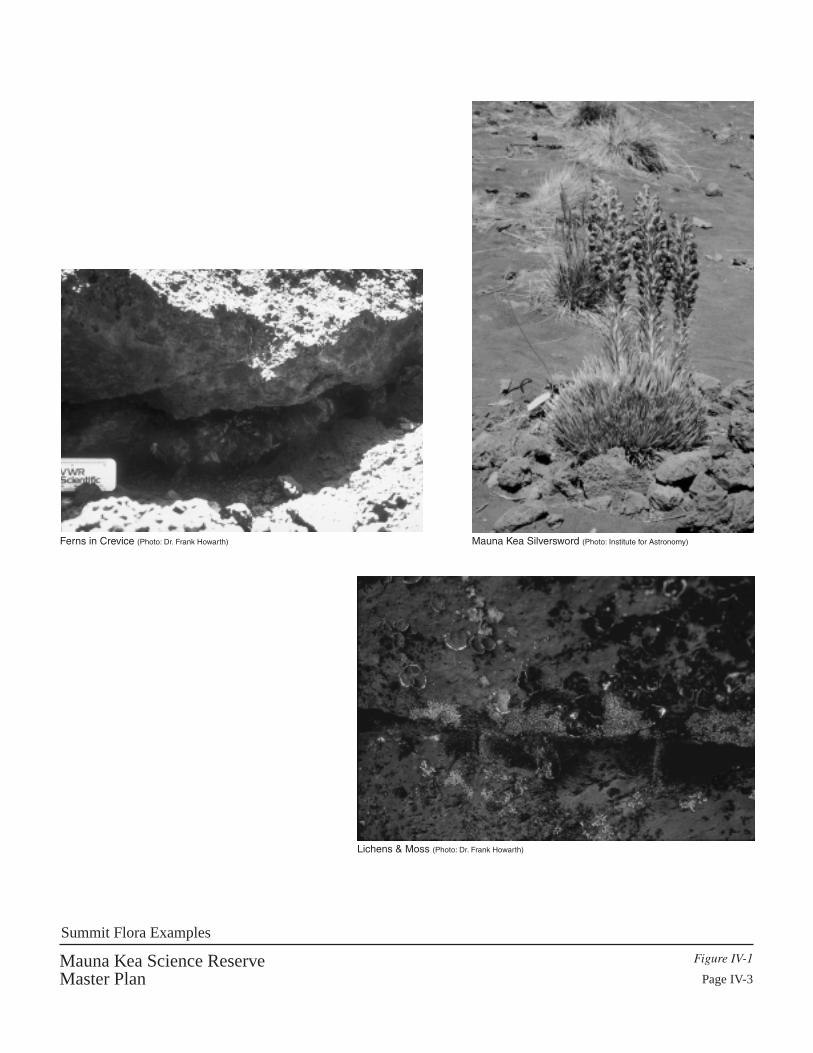
Ferns in Crevice (Photo: Dr. Frank Howarth) Mauna Kea Silversword (Photo: Institute for Astronomy)
Lichens & Moss (Photo: Dr. Frank Howarth)
Mauna Kea Science ReserveMaster Plan
Figure IV-1
Page IV-3
Summit Flora Examples

Mauna Kea Science Reserve Master Plan
Natural Environment Page IV - 4
sun. Fissures and small caves generally support lichen communities. In contrast, areaswith cinder substrate do not provide good habitat for lichens. Winona Char (1999)indicates that lichen are found throughout the summit region.
Suitable moss habitat are widely distributed over the summit area. In his 1982 study, Dr.William Hoe collected approximately 12 species of mosses in the summit area. Less thana quarter of these species are endemic to Hawaiÿi. Mosses are most abundant on north-northeast facing sides of rock mounds, as well as south-southwest facing sides of thesemounds. Some species are restricted to habitats that are at least partially protected byrock overhangs, while others are confined to deeply-shaded pockets and crevices whereliquid water is available.
Also in 1982 Dr. Peter O’Conner studied vascular plants in the summit area of MaunaKea and collected six different species. The Cystopteris douglasii is an endemic speciesfound only in a few high altitude locations in the state. Vascular plants are found in areasof stable substrate. Most ferns are found within or at the base of andesitic rock outcropswhere protection from sun and wind permits the accumulation of small amounts of soiland moisture. The Mauna Kea Silversword, a sub-species unique to this mountain, wasonce found in the summit area. It is suspected that feral ungulates destroyed much of thisand other vegetation types.
The harsh climate of the Mauna Kea summit proves to be a difficult environment for thesurvival of many species. The summit region is an aeolian ecosystem where strongwinds distribute dust, cinder, and food sources such as insects. The major component ofthe fauna on the Mauna Kea summit are arthropods such as spiders, moths, mites,springtails, centipedes, booklice, barklice, and true bugs. Feral pigs will occasionallytravel to the higher elevations.
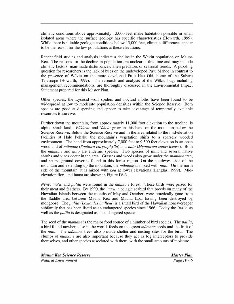
The one true bug found on the summit is the Wëkiu bug (Nysius wëkiuicola). The bughas been found only in the summit area of Mauna Kea above about 12,800 foot elevation,however, recent fieldwork has identified suitable habitat down to approximately 11,800feet (Howarth, 1999) (Figure IV-2 and Section IX). A relative of this bug is found onMauna Loa.
The Wëkiu is found under large boulders and in among loose cinders. Researchersspeculate that undisturbed cinder cones allow the bug to migrate vertically within thesubstrate to escape cold and drought and to seek moisture. Larger pore spaces in thecinder allow movement and provide resting and hiding spaces. The Wëkiu is a long-legged, black carnivore which does not fly. The Wëkiu survives on the water and insectscarried by the wind and deposited to the substrate in melting snow.
The Wëkiu has been the subject of extensive study by the team of Francis Howarth,Gregory Brenner, and David Preston. From August 1997, to September, 1998 a total of179 person days have been spent on the mountain in sampling and reconnaissance work.The summit’s areas with the most suitable habitat for the Wëkiu are shown in Figure IX-9 and discussed more in that section. In addition to broad areas of suitable substrate, the

Wëkiu Bug (Photo: William P. Mull)
Agrotis, moth (Photo: Stephen L. Montgomery)
Lycosa, wolf spider (Photo: Wiliam P. Mull)
Average Size of Wëkiu Bug
Mauna Kea Science ReserveMaster Plan
Figure IV-2
Page IV-5
Summit Fauna Examples
Mauna Kea Science Reserve Master Plan
Natural Environment Page IV - 6
climatic conditions above approximately 13,000 feet make habitation possible in smallisolated areas where the surface geology has specific characteristics (Howarth, 1999).While there is suitable geologic conditions below 13,000 feet, climatic differences appearto be the reason for the low populations at these elevations.
Recent field studies and analysis indicate a decline in the Wëkiu population on MaunaKea. The reasons for the decline in population are unclear at this time and may includeclimatic factors, man-made disturbances, alien predators or seasonal trends. A puzzlingquestion for researchers is the lack of bugs on the undeveloped Puÿu Mahoe in contrast tothe presence of Wëkiu on the more developed Puÿu Hau Oki, home of the SubaruTelescope (Howarth, 1999). The research and analysis of the Wëkiu bug, includingmanagement recommendations, are thoroughly discussed in the Environmental ImpactStatement prepared for this Master Plan.
Other species, the Lycosid wolf spiders and noctuid moths have been found to bewidespread at low to moderate population densities within the Science Reserve. Bothspecies are good at dispersing and appear to take advantage of temporarily availableresources to survive.
Further down the mountain, from approximately 11,000 foot elevation to the treeline, isalpine shrub land. Pükiawe and ÿöhelo grow in this band on the mountain below theScience Reserve. Below the Science Reserve and in the area related to the mid-elevationfacilities at Hale Pöhaku the mountain’s vegetation shifts to a sparsely woodedenvironment. The band from approximately 7,000 feet to 9,500 feet elevation is an openwoodland of mämane (Sophora chrysophylla) and naio (Myoporum sandwicense). Boththe mämane and naio are endemic species. Two species of mint and several nativeshrubs and vines occur in the area. Grasses and weeds also grow under the mämane tree,and sparse ground cover is found in this forest region. On the southwest side of themountain and extending up the mountain, the mämane is mixed with naio. On the northside of the mountain, it is mixed with koa at lower elevations (Langlas, 1999). Mid-elevation flora and fauna are shown in Figure IV-3.
Nënë, ÿuaÿu, and palila were found in the mämane forest. These birds were prized fortheir meat and feathers. By 1990, the ÿuaÿu, a pelagic seabird that breeds on many of theHawaiian Islands between the months of May and October, were practically gone fromthe Saddle area between Mauna Kea and Mauna Loa, having been destroyed bymongoose. The palila (Loxioides bailleui) is a small bird of the Hawaiian honey-creepersubfamily that has been listed as an endangered species since 1966. Today the ÿuaÿu aswell as the palila is designated as an endangered species.
The seed of the mämane is the major food source of a number of bird species. The palila,a bird found nowhere else in the world, feeds on the green mämane seeds and the fruit ofthe naio. The mämane trees also provide shelter and nesting sites for the bird. Theclumps of mämane are also important because they act as fog interceptors to providethemselves, and other species associated with them, with the small amounts of moisture

Naio (Photo: Winona Char) Mämane (Photo: Winona Char)
Mämane Forest (Photo: Winona Char)
Palila and Mämane (Photo: Audibon Society "Birds of Hawai‘i")
Mid-Elevation Flora and Fauna Examples
Mauna Kea Science ReserveMaster Plan
Figure IV-3
Page IV-7
Mauna Kea Science Reserve Master Plan
Natural Environment Page IV - 8
they need for survival. Pualani Kanahele and Edward Kanahele (1997) discuss theimportance of the mämane forest as a food source for the palila. The Kanahele’s explainthat in the Hawaiian hierarchy system, the important entity is the source of food and notthe animal that depends on this food. Noting this, the Kanahele’s explain that it is mostimportant to preserve the mämane forest as a cultural resource.
Introduced Mammals and the Destruction of Vegetation
In the late 1700s and early 1800s cattle were introduced and soon ran wild in the saddlebetween Mauna Loa and Mauna Kea. In addition to wild cattle, sheep and goats thrivedon the mountain. As early as the 1820s, feral ungulates began destroying the summitarea’s silversword population and any other plants not protected in rocky crevices. In the1820s and 1830s, Western, and later Hawaiian, hunters stalked wild cattle roaming themid-elevation area slopes which were covered in pili grass and mämane trees. However,this activity was not enough to keep the population in check. Feral sheep and goatsdestroyed large portions of the mämane ecosystem by eating the leaves, stems, seedlings,and sprouts of the plants. The ungulate grazing has caused a gradual shift in the balanceof trees from mämane to naio. By 1850, the cattle had visibly destroyed portions of theupper ÿöhiÿa-koa forest by eating the underbrush and stripping the trees. (Cordy, 1994)In a relatively short period of time, the landscape and use of the upper slopes of MaunaKea changed dramatically.
By the late 1920’s much of the vegetation had been destroyed and a government-sponsored eradication program began. Through hunting, fencing, and stock drives, feralcattle were eliminated from Mauna Kea and the feral sheep population, estimated at40,000 in the mid 1930s was reduced to nearly 200 by 1950 (Giffin in Juvik and Juvik,1984). With the decrease in wild animals, the forests of Mauna Kea began to regeneratethemselves. Juvik and Juvik report that forest management policies shifted once again inthe period following World War II. The number of game hunters increased and theywere able to convince the government that sport hunting should be supported. In areasfavored by hunters, the forest continued to regenerate. However, in less accessible areasthe game returned and further damaged the fragile forest.
By destroying vegetation the rampant ungulates destroyed critical habitat for the palila.Efforts to protect the endangered palila bird resulted in a 1979 Federal court ordermandating the removal of feral sheep and goats from the critical habitat area. A 1987federal court order dictated the complete and permanent removal of all mouflon andhybrid sheep from the mountain. Though not popular with hunters, sheep and goateradication programs have kept the numbers of feral ungulates in check and have assistedthe revegetation of certain areas of the mountain. Over 30,000 acres of the mämane-naioforest have been designated as the critical habitat of the palila. Mämane revegetationprograms have been undertaken to replenish the palila habitat. Revegetation efforts nearthe Hale Pöhaku facilities have favorable chances of success as the human activity tendsto keep destructive animals out of the area.
MAUNA KEA SCIENCE RESERVE MASTER PLAN
V. CULTURE

Mauna Kea Science Reserve Master Plan
Culture Page V - 1
CULTURE
The First Arrivals: Native Hawaiian Uses
In Hawaiian culture, natural and cultural resources are one and the same. Nativetraditions describe the formation of the Hawaiian Islands and the presence of life on andaround them. All forms of the natural environment, from the skies and mountain peaks,to the valleys and plains, and to the shoreline and ocean depth are the embodiments ofHawaiian gods and deities. One Hawaiian genealogical account records that Wäkea (theexpanse of the sky) and Papa-häna-moku (Papa – Earth mother who gave birth to theislands) and various gods and creative forces of nature gave birth to the islands. Hawaiÿi,the largest of the islands, was the first-born of these island children. The accountcontinues that the same god-beings were also the parents of the first man (Häloa), andfrom this ancestor, all Hawaiian people are descended. In some genealogical chants,Mauna Kea is referred to as “Ka Mauna a Kea” (Wäkea’s Mountain), and it is likened tothe first-born of the Island of Hawaiÿi. (Maly, 1999)
“Cultural attachment is demonstrated in the intimate relationship (developed overgenerations of experiences) that a people of a particular culture share with their landscape– for example, the geographic features, natural phenomena and resources, and traditionalsites, etc., that make up their surroundings. This attachment to environment bears directrelationship to the beliefs, practices, cultural evolution, and identity of a people. InHawaiÿi, cultural attachment is manifest in the very core of Hawaiian spirituality andattachment to landscape. The creative forces of nature which gave birth to the islands(e.g., Hawaiÿi), mountains (e.g. Mauna Kea) and all forms of nature, also gave birth to näkänaka (the people), thus in Hawaiian tradition, island and humankind share the samegenealogy.” (Maly, 1999, p. 27)
According to Kanahele and Kanahele (1997), the first Hawaiians landed on the island’sshores between 25 BCE and 125 CE. Many more Polynesians voyaged to Hawaiÿi andsettled over the next thousand years. During this settlement period, the early Hawaiiansdeveloped stable water and food sources and adapted to their new environment.(Kanahele and Kanahele, 1997) Hawaiians first settled near the shore where there wasready access to the ocean’s plentiful resources. The forests provided plants and animalsfor food, tools, and shelter. Flightless birds, knowing no predators before, became easyprey for Hawaiian hunters. The mountain tops, the highest points of the land, wereconsidered sacred. Mauna Kea is among the most sacred of these high points.
As early as AD 1100, adze makers came in reverence to the Mauna Kea adze quarry,Keanakäkoÿi (most of which is located in the Mauna Kea Ice Age Natural Area Reserve),to craft tools from the unique dense basalt found here. As part of the ritual associatedwith quarrying, craftsman erected shrines to their gods. Adze makers came to themountain for short periods of time to work on the basalt that formed from molten lavawhich erupted under the glacial ice cap. They chipped out chunks of basalt and then

Mauna Kea Science Reserve Master Plan
Culture Page V - 2
worked the stone to form refined tools in shelters and workshops they had built.Different areas were designated for chipping, rough-finishing, and fine-finishing.Mämane wood was preferred for adze handles. In addition to the quarrying of adzebasalt, craftsmen also collected volcanic glass and dunnite/gabbro for cutting tools andoctopus fishing gear sinkers (McCoy, various and Maly, 1999). Further down themountain, near a spring, the adze makers erected shelters from which they would gatherwater, wood, and food to sustain them as they worked in the quarry. (PHRI, 1997)Remnants of shelters, shrines, adze manufacturing, food and offerings remain today totell of these early craftsmen. The adze makers are thought to have come fromneighboring areas and the adzes they crafted were widely used. Keanakäkoÿi was anactive place for hundreds of years, with intensive use after AD 1400 and eventual declineprior to Western contact.
Following the long period of initial settlement, an era of high culture ensued. TheHawaiian society advanced in all areas from the 1200s until the late 1700s. During thistime political powers exerted their might and the structure of communities was refined.(Kanahele and Kanahele, 1997)
In the beginning of the 1600s, during the time of Umi, the Hawaiian Islands were dividedinto political regions. The larger islands (mokupuni) were divided into districts (moku).The moku were divided into ahupuaÿa and large ahupuaÿa were divided into ÿili.Ahupuaÿa were often entire valleys spanning from the top of the mountain ridge to theocean. The konohiki managed the day-to-day operations of the ahupuaÿa with the aid ofluna who were experts in various fields such as planting and fishing. Each ahupuaÿacontained nearly all of the resources Hawaiians required for survival from fresh water,plants, and a variety of animals, and was managed so that these resources could besustained over time. (The Ahupuaÿa, 1994)
The ahupua’a of Kaÿohe spans the summit of Mauna Kea and includes the Mauna KeaScience Reserve (Figure V-1). The lower slopes of Mauna Kea reach into the ahupuaÿaof Humuÿula and Kaÿohe. Hawaiians hunted and gathered in Mauna Kea’s mämaneforests which were rich with vegetation and native birds including the ÿuaÿu (dark-rumped petrel), nënë, and palila. So prized were the plump young ÿuaÿu that they couldbe eaten only by the aliÿi. Hawaiians came to the koa and ÿöhiÿa forest on the mountain’slower slopes to gather wood for canoe-making and to collect bird feathers. Above thekoa forests was the open mämane forest where they may have hunted ÿuaÿu and nënë.
All aspects of Hawaiian life were steeped in ritual. For the Hawaiian people, spiritualbeliefs, cultural practices and all facets of daily life were intricately bound to the naturallandscape of the islands. The lake, Waiÿau, was believed to contain pure water associatedwith the god Käne and was used in healing and worship practices. Archaeologist PatMcCoy suggests that shrines located at the edge of the summit plateau may mark thetransition to a spiritual zone associated with the summit of Mauna Kea (McCoy andMcEldowney, 1982). The shrines may be associated with the snow line and thus
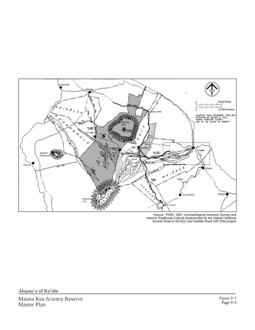
Figure V-1Page V-3
Mauna Kea Science ReserveMaster Plan
Ahupua‘a of Ka‘ohe
Source : PHRI, 1997, Archaeological Inventory Survey andHistoric Traditional Cultural Assessment for the Hawai‘i Defense
Access Road A-AD-6(1) and Saddle Road (SR 200) project
© ~

Mauna Kea Science Reserve Master Plan
Culture Page V - 4
represent shrines to Poliÿahu and/or other deities. Hawaiians also buried the bones oftheir dead on the slopes of Mauna Kea.
Archaeology and Ethnographic Research
What we know today of Mauna Kea’s ancient use and meaning we have learned from thephysical clues left behind on the mountain. Ethnographic research explores more recenthuman activity and the traditions that have been handed down within families over time.
For the past two decades archaeologists have conducted extensive field work on theslopes of Mauna Kea, with access made much easier with the construction of a road tosummit area. Approximately 3,000 acres, or 27 percent, of the Science Reserve has beensurveyed to date (McCoy, 1999). Much of this archaeological work has been undertakenby Dr. Patrick McCoy, currently with the State Historic Preservation Division. McCoyand colleague Dr. Holly McEldowney have prepared an Historic PreservationManagement Plan for Mauna Kea. As part of this plan, McCoy has inventoried andsummarized the archaeological sites that provide a wealth of knowledge of past use of themountain (McCoy, 1999) (Figures V-2 and V-3).
In addition to the archaeological field work, several individuals have recently conductedethnographic studies concerning Mauna Kea. Their research is summarized here.
Dr. Charles Langlas of the University of Hawaiÿi-Hilo worked with Paul H. Rosendahl,Ph.D., Inc. to prepare an Archaeological Inventory Survey and Historic and TraditionalCultural Assessment for the Hawaiÿi Defense Access Road A-AD-6(1) and Saddle Road(SR 200) Project (1997). Pualani and Edward Kanahele prepared a Social ImpactAssessment of Indigenous Hawaiian Cultural Values for this same project (1997).
In association with the preparation of this Master Plan, cultural specialist Kepä Malyconducted an oral history interview and archival research effort in the later part of 1998to compile the thoughts and memories that those living today have of Mauna Kea (Maly,1999). Maly interviewed 22 individuals and structured his research into broad groupingsthat are helpful in organizing the often generalized feelings that individuals have towardMauna Kea.
McCoy summarizes the most recent archaeological work within the Mauna Kea ScienceReserve. Based on field work undertaken between 1975 and 1997, a total of 93archaeological sites have been identified in surveys covering approximately 3,000 acreswithin the larger Science Reserve, including the immediate summit ridge areas. Thesesites tell us much about the history of man’s association with Mauna Kea. Of the 93sites, 76 are shrines, four are adze manufacturing workshops, and three are markers. Oneburial has been positively identified and four other possible burial sites exist. Thefunction of five of the 93 sites is unknown. (McCoy 1999)

Mauna Kea Science ReserveMaster Plan
Figure V-2
Page V-5
Archaeological Site Examples Photos: Pat McCoy

, , , / ,
, ,
.. I Shrines ~ 25' Con1our Intervals
• I Marker
E3 e I Unknown Natural Atca Reserve
• I Worksh<lp
Archaeology Sites Map - Science Reserve
Mauna Kea Science Reserve Master Plan
Sour~ : MwN;iii Department or Land Md Natural Fteoutees Hi$1oric PrC$CMtlion Division, fcbru:lry 1999
Figu..,-e V • 3 P~cV •6
Mauna Kea Science Reserve Master Plan
Culture Page V - 7
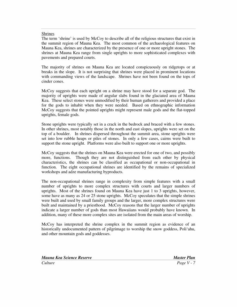
ShrinesThe term ‘shrine’ is used by McCoy to describe all of the religious structures that exist inthe summit region of Mauna Kea. The most common of the archaeological features onMauna Kea, shrines are characterized by the presence of one or more upright stones. Theshrines at Mauna Kea range from single uprights to more sophisticated complexes withpavements and prepared courts.
The majority of shrines on Mauna Kea are located conspicuously on ridgetops or atbreaks in the slope. It is not surprising that shrines were placed in prominent locationswith commanding views of the landscape. Shrines have not been found on the tops ofcinder cones.
McCoy suggests that each upright on a shrine may have stood for a separate god. Themajority of uprights were made of angular slabs found in the glaciated area of MaunaKea. These select stones were unmodified by their human gatherers and provided a placefor the gods to inhabit when they were needed. Based on ethnographic informationMcCoy suggests that the pointed uprights might represent male gods and the flat-toppeduprights, female gods.
Stone uprights were typically set in a crack in the bedrock and braced with a few stones.In other shrines, most notably those in the north and east slopes, uprights were set on thetop of a boulder. In shrines dispersed throughout the summit area, stone uprights wereset into low rubble heaps or piles of stones. In only a few cases, cairns were built tosupport the stone upright. Platforms were also built to support one or more uprights.
McCoy suggests that the shrines on Mauna Kea were erected for one of two, and possiblymore, functions. Though they are not distinguished from each other by physicalcharacteristics, the shrines can be classified as occupational or non-occupational infunction. The eight occupational shrines are identified by the remains of specializedworkshops and adze manufacturing byproducts.
The non-occupational shrines range in complexity from simple features with a smallnumber of uprights to more complex structures with courts and larger numbers ofuprights. Most of the shrines found on Mauna Kea have just 1 to 3 uprights, however,some have as many as 24 or 25 stone uprights. McCoy speculates that the simple shrineswere built and used by small family groups and the larger, more complex structures werebuilt and maintained by a priesthood. McCoy reasons that the larger number of uprightsindicate a larger number of gods than most Hawaiians would probably have known. Inaddition, many of these more complex sites are isolated from the main areas of worship.
McCoy has interpreted the shrine complex in the summit region as evidence of anhistorically undocumented pattern of pilgrimage to worship the snow goddess, Poliÿahu,and other mountain gods and goddesses.

Mauna Kea Science Reserve Master Plan
Culture Page V - 8
Adze Quarrying and ManufacturingThe main adze quarry, Keanakäkoÿi, is located within the Mauna Kea Ice Age NaturalArea Reserve. The majority of the workshops and shrines associated with adzemanufacturing are located near the main quarry. Four additional adze manufacturingworkshops have been found in the Science Reserve across the Summit Access Road fromthe adze quarry. However, these workshops are of a different kind than those found in theadze quarry. Manufacturing byproducts such as flakes, cores, adze rejects, andhammerstones have been found at these workshops, however, no stone-tool quality rawmaterial is found. Thus it is likely that adzes were flaked elsewhere and transported tothese localities at a later stage of the manufacturing process. Each workshop has one ormore shrines upon which adze byproducts were offered to the tutelary gods of adzemaking. McCoy has identified one of these workshops as the location of initiation ritesfor apprentice adze makers. (McCoy 1999)
Several of those interviewed by Maly have heard of or visited the adze quarry areas onMauna Kea.
Coco Hind recalls, “I went up once [to Mauna Kea], a long time ago, wewent up to Lake Waiau. I remember feeling kind of weak when we got upthere, and it was the thin air. I wasn’t that old. We went up to Humuÿulaand then we took horses. We rode horses up to Waiÿau. I was with myfather, my mother didn’t go. My mother was afraid of horses, shewouldn’t go near a horse.”… “… we went up and dad showed usthis…there were other people with us too, my uncle Allan and his son, andothers. He showed us this place where there were ÿöpihi shells all overand it was where daddy said that they used to rough cut the adzes and thenbring them down and finish them up, down below…” (Florence Laÿi-ke-aloha-o- Kamälu “Coco” Vrendenburg-Hind, p. A-118 in Maly, 1999)
Trails and AccessIn pre-contact times, it is suspected that travel to Mauna Kea was guided by individualknowledge of the landscape rather than by any distinct trails. It is possible that ridgeswere followed or that sources of water were known and visited along the way.Individuals going up the mountain likely visited the shrines erected by their familymembers to their gods. No evidence of pre-contact trails has been documented.(McEldowney, 1999)
Maly reports that by the later nineteenth and early twentieth centuries, trails were createdand often traveled on horseback. The trails of Mauna Kea linked communities andcultural and natural resources together. To reach the summit, people left the near-shoreand plains lands and traveled the mountain slopes to the summit. The trails ascend theslopes of Mauna Kea from nearly all of the major, and many of the smaller ahupuaÿawhich lie upon Mauna Kea’s slopes. Traditions pertaining to journeys on the mountaintrails, and knowledge of Mauna Kea are still retained as important family history today.Mauna Kea’s trails, as told of in the oral and written histories, are depicted on the
Mauna Kea Science Reserve Master Plan
Culture Page V - 9
annotated interview map (Figure V-4). Significantly, many of these trails converge atWaiÿau, in the Natural Area Reserve.
Interviewees told Maly of their elders travelling to Mauna Kea to worship in the summitregion, gather water from Waiÿau for healing practices, procure stone for adze making,and take individuals’ ash remains to the summit area or to Waiÿau for their return to theEarth. Teddy Bell describes one of the mountain trails to Waiÿau.
“And then we also went from Waikiÿi” . . .“You go so far from Puÿu Läÿau. . . There used to be one pine tree forest. And from that reserve, there’s aclump of pine trees. That’s where they’ve got a lot of cones. From thatpine trees, you look at Mauna Kea, the two sides, it’s almost like a pali butwide. And then you right up through that hollow there, and you come upto Lake Waiau. Almost to the end of the pali on Mauna Kea.” (Theodore“Teddy” Bell, Sr., p. A-128 in Maly, 1999) (This trail is indicated inFigure V-4 as K Waikiÿi-Waiau trail.)
During the historic period, people have traveled the mountain for Territorial Forestryoperations, ranching, hunting, and recreational activities. Lloyd Case describes gametrails on the mountain.
“You know one of the most amazing things, and I don’t know if some ofthe old timers told you this. But a lot of these Hawaiian trails, a lot ofthem were used by the sheep, they became game trails after a while. Thesheep would use some of these trails. Some of these trails we walked ‘em,on the Kemole side, Puÿu Mali side. But a lot of them, they are still there,but you have to have a good trained eye to find ‘em.” (p. A-348 in Maly,1999)
BurialsAs was mentioned earlier, no shrines have been identified on top of cinder cones in theMauna Kea Science Reserve. McCoy believes that these high and remote places werereserved for burying the dead. Although there are references to human burials on MaunaKea in oral histories, only one burial site has been positively identified in the mountainsummit area.
“To date the only positively identified human remains found in the Science Reserve arelocated at Site 16248 on the summit of Puÿu Makanaka (Fig. 1). Jerome Kilmartin, asurveyor with the United States Geological Survey, noted the presence of human remainson this prominent cinder cone in 1925.” (McCoy 1999)
Four other sites within the Science Reserve have been identified as possible burials byMcCoy.

K
M
LL
Page V-10Mauna Kea Science ReserveMaster Plan
Annotated Interview Map (Kepä Maly)
-..t...i.--v-a-.r
·--_.. ... ri:n:t!
r~ II'> I ;i.~ ...,.-,.., ---uif~ ~ - ~ iMlillHI ~-pin..,..,........._ -~ n., Jt-. ■l•~l"ll!!l!lf"l!I
L-,....., .i ........ --,L ... ......-... ...... J.
....i-...,11 ,...:,w;.,,,..,._
KM--.1.11~...,...,_ r- • P'I!!'&.-. ill~~
ODil',-.'wilN°~~ • ..a-w---r-

L
CA
BE G
D
J
H
H
N
O
P
Figure V-4Page V-11
0
H;,,,w;,,, ■ Ti£MiiLT Y aul- Y If.,.,!:: \,,,!.JI. o...,,. _.,,..._
MAUN\;11, 'l<tc...... P'Olfll:.&'T 11'1:Ea'Elfll:YE. MAM t<; l,.!A lfi ■-11 '1..0, 1-1'°' · I,
~L.. 1 ln<:J. a .0-M r:., . i •
~- ~ ..,_Tke+.,1,:.11:. L-y ~, ... ., .... ~ .,...,j T:~ ~ "--;'.:~u~ j/ "-.
~ 11 •-
Mauna Kea Science Reserve Master Plan
Culture Page V - 12
“There are four other sites in the surveyed areas of the Science Reserve that havebeen identified as possible burials (Sites 16195, 21413, 21414, and 21416). Ineach case there are compelling reasons to believe that the site is indeed a burial,but because human remains were not seen at the time the site was recorded it hasbeen called a possible burial.”
Of these four possible burial sites one consists of two adjacent cairns located on theeastern rim of Puÿu Lïlïnoe. The other three are located on the southern and eastern rimof a large unnamed cinder cone on the northwestern edge of the Science Reserve.(McCoy 1999)
McCoy notes that archaeological sites have been found in all areas that have beensurveyed to date but the distribution and density of the various types of sites followscertain patterns. The one burial and four possible burials have been found only on thetops of cinder cones and never with shrines.
While none of the individuals interviewed by Maly reported knowing of specificlocations of burials in the immediate area of the Mauna Kea summit, many spoke of ilina(burial sites) in cinder cones, and other natural features in the region extending fromabout the 12,000 down to the 7,000 foot elevation. In modern times several familymembers or close friends of interviewees have had their cremated remains taken to thesummit of Mauna Kea for release.
Summit AreaA significant pattern is the virtual absence of archaeological sites at the very top of themountain. McCoy states that the “top of the mountain was clearly a sacred precinct thatmust, moreover, have been under a kapu and accessible to only the highest chiefs orpriests.”
Most of the shrines in the Science Reserve are found on the northern and eastern slopesjust above and below the 13,000 foot elevation. This pattern suggest that most of thosewho journeyed to the summit area came from the Hämäkua and Hilo sides of themountain. Discussing the scarcity of sites on the western and southwestern slopes,McCoy makes the following observations:
“While the small number of shrines on this side of the mountain suggestthe possibility of people coming from the Kona and South Kohaladistricts, the number would appear to have never been high. Theimplications are quite interesting. It suggests that while the mountain mayhave been viewed from a distance by people from everywhere on theisland as a sacred mountain, in practice those who made the journey andworshipped there did not represent an even cross-section of the islandpopulace. The implication is that access to the summit region was underthe political control of the east Hawaii chiefdoms, a conclusion that isconsistent with all of the other data.” (McCoy 1999)

Mauna Kea Science Reserve Master Plan
Culture Page V - 13
All of those interviewed by Maly attributed spirituality and healing qualities to being onMauna Kea; and several recorded that they still go to Mauna Kea for prayer andrestoration. One described Mauna Kea as a sanctuary in ancient times. The area abovethe forest line was so sacred that once in the upper region, your enemies could not pursueyou. (Maly 1999)
In addition to the sites identified within the Science Reserve, a wealth of physicalevidence can be found in the Mauna Kea Ice Age Natural Area Reserve, outside of theScience Reserve. Within the Natural Area Reserve, the main adze quarry and numeroussites at Waiÿau tell of the activity in this geologically and culturally unique area. Manyof these sites have been inventoried but have yet to be fully analyzed and related to theother sites found on the mountain.
Cultural LandscapeThe summit of Mauna Kea has been referred to as wao akua (region of the gods). Themost common understanding of wao akua is that it was a remote desolate location wherespirits, benevolent or malevolent, lived and people did not live. Usually these placeswere deep interior regions, inhospitable places such as high mountains, deserts and deepjungles. These areas were not necessarily kapu but were places generally avoided out offear or respect. Different people and family had different protocols when they traveledthrough these remote regions. (George Atta personal communication with HollyMcEldowney and Pat McCoy, June 2, 1999)
“Perhaps as a result of its prominence, isolation, and extreme environmental conditions,Mauna Kea’s place in the culture and history of the Hawaiian people is significant. This‘cultural significance’ extends beyond a physical siting, sites or particular features whichhave been previously identified in archaeological site studies. Mauna Kea is a prominentfeature on the cultural landscape of Hawaiÿi which has been and continues to be, viewedfrom afar, and to which spiritual and cultural significance is attributed.” (Maly, 1999, p.3)
The ancient saying “Mauna Kea kuahiwi ku ha‘o i ka mälie” (Mauna Kea is theastonishing mountain that stands in the calm) (Pukui 1983: No. 2147), expresses thefeeling that Mauna Kea is a source of awe and inspiration for the Hawaiian people. Themountain is a respected elder, a spiritual connection to one’s gods. Thus, the landscapecan be interpreted as a significant facet of a Hawaiian’s identify. Mauna Kea is the focalpoint of numerous traditional and historical Hawaiian practices and narratives recordedby both native Hawaiians and foreign visitors. Views of the mountain landscape arepresented in Figure V-5.
“A number of place names recorded for this mountain landscape are associated withHawaiian gods. Other place names are descriptive of natural features and resources, ordocument events that occurred on the mountain.” (Maly, 1999) “Native families also
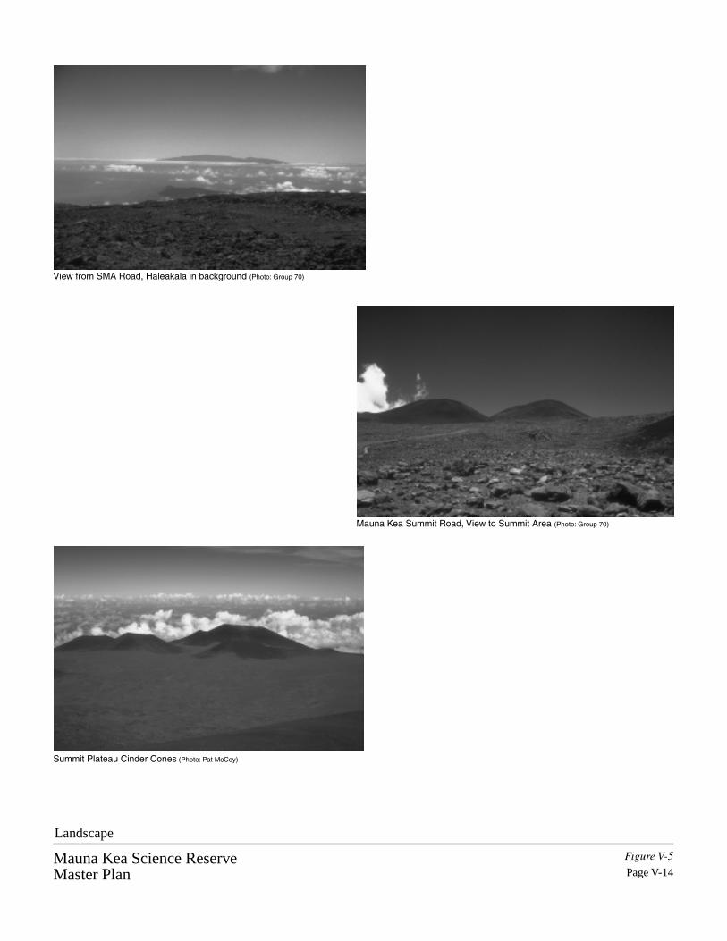
Mauna Kea Science ReserveMaster Plan
Figure V-5
Page V-14
Landscape
View from SMA Road, Haleakalä in background (Photo: Group 70)
Mauna Kea Summit Road, View to Summit Area (Photo: Group 70)
Summit Plateau Cinder Cones (Photo: Pat McCoy)

Mauna Kea Science Reserve Master Plan
Culture Page V - 15
retain names such as Maunakea, Poliÿahu, Lilinoe, and Waiÿau, which in some cases aredirectly tied to the mountain landscape.” (Maly, 1999)
The Kanaheles (1997) tell of Mauna Kea as the piko or origin point for the island ofHawaiÿi, and specifically the northern half of the island. Mauna Kea is, therefore, a placeof great mana. Kanahele has also said that the three puÿu, Poliÿahu, Lïlïnoe, and Waiÿauare named for three sister goddesses who are female forms of water. Poliÿahu isembodied in the snow, Lïlïnoe in mist, and Waiÿau in the lake. These puÿu are where thegoddesses manifest themselves. Of these three landforms two, Poliÿahu and Lïlïnoe, arelocated in the Science Reserve. Waiÿau is located in the Natural Area Reserve (Figure V-6).
Many of those interviewed by Kepä Maly expressed the significance Mauna Kea holdsfor them as Hawaiians and as individuals.
John Speilman and Pualani Kanahele describe Mauna Kea in the context of the entireIsland of Hawaiÿi and in Hawaiian ancestral history.
“And I think too, what is important to understand and for people to realizeis that it is all connected. Although we are talking about Mauna Kea,Mauna Kea and Paniau are connected. When you go fishing from Paniau,you look up to Mauna Kea and you check out the weather. You look tothe mountain and see what the weather patterns are doing. The Kohalamountains. So the fishermen use the mountains as visual aids to help themin their fishing. And perhaps, I don’t this as much, but from the mountainside down, but I would imagine that the farmers and the people that livedhigher, would look down to the ocean to see if the weather was changing,the cloud patterns on the ocean. It’s all connected. It is not separate. ButMauna Kea, I think, is the focal point of this island. It is the piko, thebreath . . .” (John K. Spielman, p. A-282 in Maly, 1999)
“Mauna Kea was always kupuna [an elder, ancestor] to us. Mauna Keaand Mauna Loa, the tips, they were always küpuna [elders, ancestors]. andthere was no wanting to go on top. You know, just to know that they werethere was just satisfying to us. And so it was kind of a hallowed place thatyou know is there, and you don’t need to go there. You don’t need tobother it. But it is there, and it exists. And it was always reassuringbecause it was the foundation for our island.” (Pualani KanakaÿoleKanahele, p. A-366 in Maly, 1999)

Mauna Kea Science ReserveMaster Plan
Figure V-6
Page V-16
Natural Area Reserve (Adze Quarry, Wai‘au)
Adze Quarry (Photo: Group 70)
Adze Quarry (Photo: Group 70)
Wai‘au (Photo: Pat McCoy)

Mauna Kea Science Reserve Master Plan
Culture Page V - 17
Alexander Lancaster and Tita Spielman relay the significance of Mauna Kea to each oftheir families.
“Yes, my grandmother Alice. Her Hawaiian name is Kamahalo – she wasnamed after her grandmother, my great, great, great grandmother. Shesaid “ When you go up there, you going feel the spirit.” And you do feelthe spirit.” (Alexander Kananiÿalika Lancaster, p. A-234 in Maly, 1999)
Regarding her family’s relationship to Mauna Kea, Spielman explains,“Well, it was through my mother, because of course, she grew up inKohala and spent a lot of time there. And at Puÿu Waÿawaÿa and Kiholo,and always loved Mauna Kea. She used to say ‘That’s my mountain.’And so we got to know it and love it as we do.” (“Tita” ElizabethKauikeölani Ruddle-Spielman, p. A-265 in Maly, 1999)
Teddy Bell and Lloyd Case relay their own personal feelings about Mauna Kea.
“On the slopes of Mauna Kea, there is a ridge there called Puÿu Nänä.Puÿu Nänä, if it’s a clear day, you can see all of this Waimea. So that’swhere I want my ashes to be scattered.” Theodore “Teddy” Bell Sr., p. A-139 in Maly, 1999)
“Because the one thing I loved about it was just going up there and sittingdown under the tree and looking out at space. Looking at everything.That is the most rewarding thing that I ever can say happens to me. WhenI go up there, it just heals me. That is a place for healing . I come back adifferent person.” (Lloyd Case, p. A-353 in Maly, 1999)
A gentleman interviewed by Langlas was taught by his great-grandparents that there weretwo sites of ritual importance on Mauna Kea, the summit peak and the lake andsurrounding puÿu Waiÿau. According to this individual, the summit peak was a place togo and pray to the gods for mana, to cleanse the person and give him health.
Waiÿau is a place of tradition and a source of inspiration. Located outside the ScienceReserve in the Natural Area Reserve, Waiÿau is a focal point for many visitors to themountain. Many of the individuals interviewed by Kepä Maly discussed their own visitsor visits by family members to Waiÿau.
“It [Mauna Kea] brings back memories, you know. But way back, peoplenever used to go up there. They never did go to Mauna Kea except onhorse back, and that was very few. And right at Lake Waiau, had a bottlethere. Whoever went up, would write their name and the date, and put itin the bottle.” . . .” Yeah. So, I don’t know what happened to that bottle.My first trip to Mauna Kea was in 1934. And there were a few peoples

Mauna Kea Science Reserve Master Plan
Culture Page V - 18
names in that bottle already.” (Theodore “Teddy” Bell Sr., p. A-123 inMaly, 1999)
Kepä Maly, “And you mentioned that Waiau was a favorite place [of yourgrandfather Eben Low].” Tita Spielman, “A very favorite place. Yes, andthat’s why his plaque was put there. Because that was one of his favoriteplaces. Although, his ashes were scattered at the top, the plaque was putat Waiau.” (“Tita” Elizabeth Kauikeölani Ruddle-Spielman p. A-270 inMaly, 1999)
In addition to feelings of aloha expressed for the place, numerous oral traditions of theimportance of Waiÿau have been handed down through families.
Kepä Maly, “So he [your father] would go mauka to Waiau and gatherwater there?” Anita Lancaster, “And he would bring it, and he had mymom and I drink that water. And if we had it for a week, it never wentinto the refrigerator, it stayed on the counter, but it was always cold. Andthat was the sweetest water. It was so pure. I thought nothing of itbecause I was so young. But as I grew older, I would always remember itbecause my dad always had this gallon hanging, you know when he didn’tgo hunt, the gallon was always hanging in the house. In fact, the last timeI saw it was just before he died, and then I don’t know what happened tothe gallon…” (Anita Leilani (Kamakaÿala) Landcaster, p. 245 in Maly,1999)
“The water they used…the läÿau lapaÿau, the healers went to thisparticular place, and another place in the Kohala mountains, there isanother spring up there which Papa Auwae uses.” . . . “So, I’ve heard ofthe old ones getting water from Waiau to use for healing. (Lloyd Case, p.A-353 in Maly, 1999)
“And so here, within the Mauna a Wäkea, sits this ÿapu wai [watercontainer] which is Waiau. What they are calling Lake Waiau. And as ithasn’t had a chance to come down to the rest of us, then it is sacred water,like the water that is in the piko of lau kalo [taro leaf], and the water that isfound in the ÿohe [bamboo – interpreted as the meaning of the ahupuaÿaname Kaÿohe, within which the summit of Mauna Kea and Waiau aresituated]. And the water that is found also in the niu [coconut]. So youhave all of these different, sacred waters, but to me, that water, Waiau, isthe most sacred because it isn’t the water that has been spilled, it is still upthere in the realm of Wäkea.”. . . “The most sacred of all the waters.”(Pualani Kanakaÿole Kanahele p. A-368 in Maly, 1999)
In ca. 1881, Dowager Queen Emma ascended Mauna Kea on a journey of spiritual andphysical well-being. At the time, Queen Emma was in competition with David Kaläkaua

Mauna Kea Science Reserve Master Plan
Culture Page V - 19
for the position of ruling chief for the Kingdom of Hawaiÿi. Each of the two embarkedon journeys to prove their connection to the senior line and connect back to a wahi pana(a sacred physical place). Emma went to the top of Mauna Kea to bathe in the waters ofWaiÿau, and cleanse herself in the piko of the island. (Kanahele and Kanahele, 1997)
For some, Waiÿau has a special family tie. “…Hawaiian members of the Lindsey familyhave a tradition of taking the piko of their children to Waiÿau and the summit of MaunaKea.”. “Other interviewees who had not heard of the practice of taking piko to MaunaKea all felt that it was likely to have occurred, and they shared similar stories from theirown families of the custom at various localities.” (Maly, 1999)
Kanahele explains the importance of this tradition of taking the piko to a particular place.
“I don’t personally know any families [who took the piko to Waiau]. Iknow that people took piko there, I just don’t know who.” . . . Well, thepiko is that part of the child that connected the child back to the past.Connected the child back to the mama. And the mama’s piko is connectedto her mama, and so on. So it takes it back, not only to the wä kahiko[ancient times], but all the way to Kumu Lipo.” . . . “So, it’s not only thepiko, but it is the extension of the whole family that is taken and put up ina particular place, that again connects to the whole family line. And it notonly gives mana or life to the piko and that child, but life again to thewhole family.” (Pualani Kanakaÿole Kanahele p. A-368 in Maly, 1999)
The Physical Planning Guide (Section IX) incorporates the information gained frominterviews, ethnographic, research, and archaeology studies to determine areasrecommended for preservation. The Management Plan (Section X) uses this sameinformation in making recommendations for the establishment and operation of a localmanagement authority.
The First European Contact to the Islands
As evidenced by the archaeological evidence and though oral histories, Hawaiian adze-making and worship at Mauna Kea continued through the 1700s.
In 1778, the first foreigner arrived in Hawaiÿi. In the decades that followed, life inHawaiÿi changed dramatically with the introduction of new technologies, religion,diseases, animals, and industry. The population of Hawaiians was decimated by theeffects of diseases that had never been seen before in the islands. Port towns such asKailua, Kealakekua and Hilo developed into commercial centers accommodatingWestern ships. Adze quarrying on Mauna Kea ceased to exist as stone adzes were soonreplaced by metal tools after European contact.
In the late 1700s and through the 1800s several Europeans led expeditions to Mauna Kea.The names Goodrich, Baldwin and Alexander are well-known to students of the
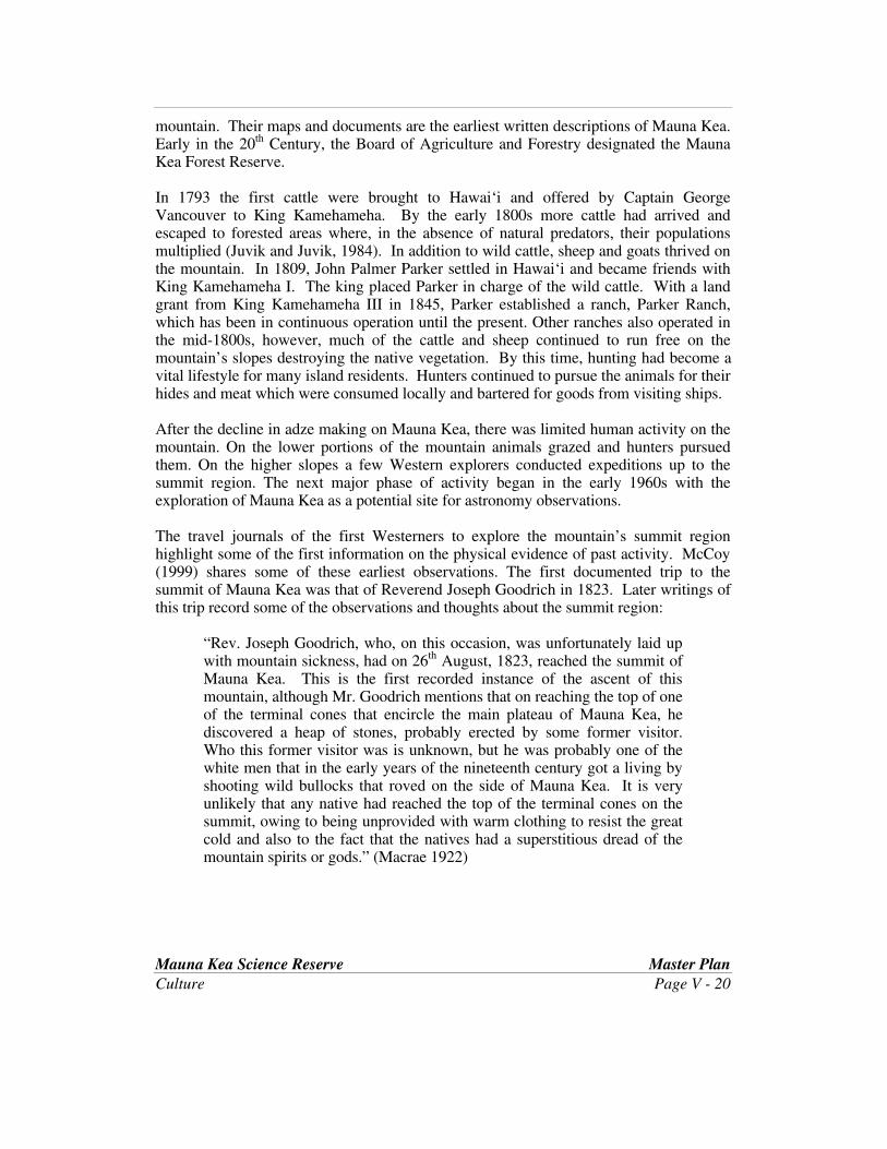
Mauna Kea Science Reserve Master Plan
Culture Page V - 20
mountain. Their maps and documents are the earliest written descriptions of Mauna Kea.Early in the 20th Century, the Board of Agriculture and Forestry designated the MaunaKea Forest Reserve.
In 1793 the first cattle were brought to Hawaiÿi and offered by Captain GeorgeVancouver to King Kamehameha. By the early 1800s more cattle had arrived andescaped to forested areas where, in the absence of natural predators, their populationsmultiplied (Juvik and Juvik, 1984). In addition to wild cattle, sheep and goats thrived onthe mountain. In 1809, John Palmer Parker settled in Hawaiÿi and became friends withKing Kamehameha I. The king placed Parker in charge of the wild cattle. With a landgrant from King Kamehameha III in 1845, Parker established a ranch, Parker Ranch,which has been in continuous operation until the present. Other ranches also operated inthe mid-1800s, however, much of the cattle and sheep continued to run free on themountain’s slopes destroying the native vegetation. By this time, hunting had become avital lifestyle for many island residents. Hunters continued to pursue the animals for theirhides and meat which were consumed locally and bartered for goods from visiting ships.
After the decline in adze making on Mauna Kea, there was limited human activity on themountain. On the lower portions of the mountain animals grazed and hunters pursuedthem. On the higher slopes a few Western explorers conducted expeditions up to thesummit region. The next major phase of activity began in the early 1960s with theexploration of Mauna Kea as a potential site for astronomy observations.
The travel journals of the first Westerners to explore the mountain’s summit regionhighlight some of the first information on the physical evidence of past activity. McCoy(1999) shares some of these earliest observations. The first documented trip to thesummit of Mauna Kea was that of Reverend Joseph Goodrich in 1823. Later writings ofthis trip record some of the observations and thoughts about the summit region:
“Rev. Joseph Goodrich, who, on this occasion, was unfortunately laid upwith mountain sickness, had on 26
th August, 1823, reached the summit ofMauna Kea. This is the first recorded instance of the ascent of thismountain, although Mr. Goodrich mentions that on reaching the top of oneof the terminal cones that encircle the main plateau of Mauna Kea, hediscovered a heap of stones, probably erected by some former visitor.Who this former visitor was is unknown, but he was probably one of thewhite men that in the early years of the nineteenth century got a living byshooting wild bullocks that roved on the side of Mauna Kea. It is veryunlikely that any native had reached the top of the terminal cones on thesummit, owing to being unprovided with warm clothing to resist the greatcold and also to the fact that the natives had a superstitious dread of themountain spirits or gods.” (Macrae 1922)

Mauna Kea Science Reserve Master Plan
Culture Page V - 21
An account of Alexander’s journey in 1892 mentions the presence of a cairn at the top ofa cinder cone:
“Messrs. Muir and Alexander ascended the second highest peak on thenorthwest, overlooking Waimea, 13,645 height to continue their survey.In the cairn on the summit a tin can was found, which contains briefrecords of the visits of five different parties from 1870 to the presenttime, to which we added our own.” (Alexander 1892)
Reflecting this notion, Ellis (1979) looked back to the travels of Goodrich and Blatchely,who ascended the peak about six months after Goodrich, and provided this description ofHawaiians’ view of Mauna Kea.
“The snow on the summit of the mountain, in all probability, induced thenatives to call it Mouna-Kea (mountain white), or, as we should say, whitemountain. They have numerous fabulous tales relative to its being theabode of the gods, and none ever approach the summit – as, they say,some who have gone there have been turned to stone. We do not knowthat any have been frozen to death; but neither Mr. Goodrich, nor Dr.Blatchely and his companion, could persuade the natives, whom theyengaged as guides up the side of the mountain, to go near its summit.”(Ellis 1979)
The early exploration of the summit region and the subsequent development of theastronomy industry on the mountain is detailed further in the Education and Researchsection of this report.
Cultural Practice Today
In their ethnographic work Maly, Langlas, and Kanahele and Kanahele describe some ofthe practices that individuals and families conduct on Mauna Kea today. Several of theindividuals interviewed by Maly stated that “they still go to Mauna Kea for prayer andrestoration”. All interviewees attributed spirituality and healing qualities to being onMauna Kea. (Maly, 1999)
Dr. Langlas interviewed a woman of the Poliÿahu line, meaning that Poliÿahu is one ofher family’s ÿaumakua. This family has designated an individual as their kahu forworship of Poliÿahu. This individual has constructed a shrine on Mauna Kea to worshipPoliÿahu and has incorporated a stone given to her by the family. She considers thewhole mountain to be sacred and feels that it is appropriate to worship anyplace on themountain if one is spiritually guided there. Thus, worship should not be limited totraditional sites. The shrine placed by this kahu is not located in a traditional site butrather in a place that she was guided to.

Mauna Kea Science Reserve Master Plan
Culture Page V - 22
Maly’s interviewees also report of the practice of taking ash remains to the summit ofMauna Kea for release. Two of the individuals interviewed by Maly have instructed thatupon their deaths, their ashes are to be taken to specific places on the slopes of MaunaKea.
While the ethnographic research provides few accounts of actual cultural practices on themountain, other individuals and groups may visit the mountain for worship on specialoccasions or on a regular basis. Many more carry with them an esteem and respect forMauna Kea.
“In both its genealogical associations and its physical presence on the island landscape,Mauna Kea is a source of awe and inspiration for the Hawaiian people. In Hawaiianpractice elders are revered – they are the connection to one’s past – and they are lookedto for spiritual guidance. Because of its place in the Hawaiian genealogies, Mauna Kea,the landscape itself is a sacred ancestor.” (Maly, 1999, p. D-25) This is the spirit withwhich many view the mountain today.

MAUNA KEA SCIENCE RESERVE MASTER PLAN
VI. EDUCATION AND RESEARCH
Mauna Kea Science Reserve Master Plan
Education and Research Page VI - 1
EDUCATION AND RESEARCH
Searching for a New Industry
As ranching operations dominated the inland areas, the port towns of Kawaihae, Kailua,and Hilo continued to grow.
In May of 1960, a powerful tidal wave washed through the town of Hilo, destroyingproperty and severely damaging the economy. In looking for a new industry to help savethe island’s economy, the Hawaiÿi Island Chamber of Commerce, with the support ofGovernor John Burns, approached universities in the United States and Japan with theidea of developing Mauna Kea and Mauna Loa as astronomy locales.
What started as a search for a new industry has resulted in new knowledge, expertise, andlearning opportunities in a variety of fields.
Evolution of Astronomy on Mauna Kea
Dr. Gerard Kuiper, of the University of Arizona, was already working with NASA andthe Department of Defense to test sites on Haleakalä and was eager to explorepossibilities on Hawaiÿi Island. While Haleakalä was considered a good site, andtelescopes were subsequently developed there, Kuiper preferred to find a site furtherabove the cloud layer. Having flown over Mauna Kea, Kuiper became interested in itspotential and developed a plan for site testing. Mauna Loa was less favored because ofthe possibility of volcanic activity (Parker, 1994).
To support this testing, Dr. Kuiper persuaded then Governor John Burns to provide fundsto establish a jeep trail to the summit area. In 1964, a NASA-funded 12.5 -inch telescopewas installed on Puÿu Poliÿahu and Kuiper’s team began “seeing” studies. Kuiperconcluded that “The mountaintop is probably the best site in the world – I repeat – in theworld - from which to study the moon, the planets, and stars.” With this exclamation, anew industry was born in Hawaiÿi.
Many now understand what Dr. Kuiper first saw. Mauna Kea is one of the finestlocations in the world for ground-based astronomical observations. Because of itslocation high on an island in the Pacific, the sky above the mountain is generally cloud-free. This gives Mauna Kea one of the highest proportion of clear nights in the world, animportant factor given the number of researchers requesting observing time. The stabilityof the atmosphere at Mauna Kea, free from disturbance caused by neighboring landforms, allows more detailed observations than available elsewhere. Finally, the summit’sheight above the tropical inversion cloud layer provides summit skies that are pure, dryand free from atmospheric pollutants.

Mauna Kea Science Reserve Master Plan
Education and Research Page VI - 2
During 1965, Dr. John Jefferies’ team from the University of Hawaiÿi and GerardKuiper’s team from the University of Arizona conducted extensive tests of the skies atMauna Kea. The two universities, along with Harvard University, applied to NASA forfunding of a new telescope on Mauna Kea. In 1965, NASA accepted the University ofHawaiÿi’s proposal and agreed to fund the design and construction of the telescope.Construction of the UH 88-inch (also known as the UH 2.2-meter) telescope began in theFall of 1967. Images of some of the early work on the mountain are presented in FigureVI-1.
The University of Hawaiÿi Institute for Astronomy was founded in 1967 and isresponsible for carrying out research in astrophysics and planetary science and for thedevelopment and management of the Mauna Kea Science Reserve. University ofHawaiÿi scientists have access to a guaranteed fraction of viewing time on all of MaunaKea’s telescopes.
In 1968, the State Board of Land and Natural Resources recognized the importance ofMauna Kea for astronomy observations and leased an area of land to the University ofHawaiÿi for a 65 year period. (In 1998, the lease area known as the Mauna Kea ScienceReserve was modified to exclude the Natural Area Reserve parcels [designated in 1981]leaving a total area of 11,288 acres under the agreement.) The Science Reserve includesthe lands from approximately 12,000 foot elevation to the summit. The Natural AreaReserve contains two parcels. The largest is a pie shaped area of land extending from theSummit Access Road to Pöhakuloa Gulch and containing the main adze quarry andWaiÿau. The second Natural Area Reserve parcel on Mauna Kea contains Puÿu Pöhaku, acinder cone that contains evidence of the ice age in permafrost.
Working astronomy on Mauna Kea advanced at the close of the decade with theconstruction of two 0.6-meter telescopes, provided to UH by the U.S. Air Force and byNASA in 1968 and 1969.
The 1970s brought a flurry of interest in Mauna Kea from the international astronomycommunity and the first comprehensive planning steps for the mountain. Development offour telescopes marked a decade of new beginnings on the mountain. Infrastructureplanning for the mountain was also active during this time, as Hawaiÿi took its placeamong the world’s top astronomy centers.
On the summit, the UH 2.2 meter Telescope, the Canada-France-Hawaiÿi Telescope,NASA’s Infrared Telescope Facility, and the United Kingdom Infrared Telescope wereconstructed to support optical and infrared astronomy.
In 1975, the jeep trail to the summit was realigned to eliminate some of the steep gradesand sharp turns in the original alignment. Power was supplied to each telescope facilityby on-site generators. In 1977 the first management plan for the mountain was adopted.This and subsequent plans are discussed in the Issues chapter of this plan.

Mauna Kea Science ReserveMaster Plan
Figure VI-1
Page VI-3
Evolution of Facility Development Photos: Institute for Astronomy
Governor Burns at Mauna Kea Observatory Dedication (1970)
Original Survey Work
Road Work (1988)
Mauna Kea Science Reserve Master Plan
Education and Research Page VI - 4
To support the development of these facilities, five temporary buildings were erected atthe mid-elevation level. Here construction workers slept, ate, and acclimated to thealtitude and weather.
Ever since the testing and construction of the first telescopes on Mauna Kea began duringthe late 1960s, temporary buildings and the original stone cabins at Hale Pöhaku havebeen used as a construction camp and astronomy support facility. The high elevation ofthe summit of Mauna Kea creates conditions that are difficult and potentially dangerousfor those working at and visiting the mountain. Traveling directly from sea level toalmost 14,000 feet can cause short-term high altitude effects such as light-headedness,shortness of breath, headaches, nausea, and dehydration. In extreme cases, life-threatening conditions can occur. The mid-level facilities, located at approximately 9,200feet, provide a place to rest and acclimate for those who are visiting or working on thesummit.
The Mid-Level Facility was completed and dedicated in 1983. Astronomers working atthe summit facilities for a few days were able to stay in the dorms at Hale Pöhaku tomaintain their acclimatization to the altitude. Dining and lounge areas provide rest andrelaxation for the scientists and telescope operators. Offices, a library, and small labssupport the scientific activity which draws the astronomers to Mauna Kea.
Along with construction of the Mid-Level Facility, a Visitor Information Station (VIS)was constructed below the main lodging facilities and stone cabins. The 950-square footfacility serves as an interpretive center and as the control point for visitors to themountain. It also provides a transition point where visitors can acclimate to Mauna Kea’saltitude. The VIS was developed approximately 650 feet below the main food andlodging facilities’ nearest dorm. The entire area is designed to separate the visitor andconstruction activities from astronomy support activities. Astronomers and support staffwork at night and must use the daytime hours to sleep and analyze the data that’s beencollected during the night. Visitors are accommodated in other facilities to allow thescientists to rest.
Below the VIS, a Construction Camp area has been developed. With the construction ofthe main food and lodging facility to support active astronomy observations, constructionsupport was moved further down the mountain. Two temporary buildings were relocatedfrom the main lodging area down to the Construction Camp area to support theconstruction of the W. M. Keck Observatory. One building is a dorm housing 24-29people. The other was used as a common building and includes a kitchen, dining room,and recreation area. Four 4-bedroom cabins, built to support the Subaru Telescopeconstruction crews, accommodate a total of 32 individuals. If the 1970s represented thebeginning of this new industry, the 1980s was a period of maturation with the adoption ofthe first comprehensive physical and management plan for the Science Reserve and HalePöhaku in 1983, and the development of mid-elevation facilities.

Mauna Kea Science Reserve Master Plan
Education and Research Page VI - 5
The 1990s, then, have been a decade in which astronomy at Mauna Kea has leapt forwardwith the development of some of the finest telescopes in the world. This decade has beenunsurpassed for astronomers as new discoveries and new facilities have been realized.The decade has also brought new international partners to the mountain such as Japan(Subaru), Taiwan (Submillimeter Array), and Chile, Australia, Argentina, and Brazil(Gemini). Five telescope facilities began operations this decade so far, and one more willdo so in the year 2001.
The Very Long Baseline Array (VLBA) consists of ten identical radio telescopes, each 25meters in diameter, spread across the United States from Hawaiÿi to the U.S. VirginIslands. The Hawaiÿi component of the VLBA is located at approximately the 12,000foot elevation within the Mauna Kea Science Reserve.
Envisioned in the 1983 Complex Development Plan as the University of California 10-meter Telescope, the W. M. Keck Observatory (Keck I) was completed in 1992.Subsequently, a second 10-meter telescope, Keck II, was constructed, and shortlythereafter, NASA joined the Keck team.
The most recent facilities to come on-line include Gemini North, an 8-meteroptical/infrared telescope and Subaru, an 8.3-meter optical/infrared telescope (Figure VI-2). In addition to the telescopes already described, the 1983 Complex Development Planprojected the development of a single-dish millimeter-wave or radio telescope in the1990s. This facility was expected to be 10 to 25-meters in size and located in millimetervalley with the James Clerk Maxwell Telescope and the Caltech SubmillimeterObservatory. Astronomy technology has advanced since the Research Development Planand Complex Development Plan were published in the early 1980s. As a consequence, asubmillimeter interferometer was proposed for Mauna Kea to achieve the scientificobjective of a millimeter-wave telescope. The Smithsonian’s Submillimeter Array, acomplex of 24 antenna pads and up to 12 movable antennas, will begin operations in2001. Existing and proposed astronomical facilities are discussed in Section IX.
New Astronomical Discoveries at Mauna Kea
Astronomers come to Mauna Kea in search of scientific answers to some of humanity’smost fundamental questions: How and when did the stars, planets, and galaxies form?What threats do we face from the Sun and other celestial bodies? What will be theultimate fate of the Universe?
Improvements at existing facilities and the operations of new facilities will help toanswer these questions. Scientists are now working on the interferometry technology tolink the two Keck telescopes and provide the resolving power of a telescope with a mirror85 meters in diameter. Pointing both telescopes at stars that are several hundred trillionmiles away, and then combining the observations using sophisticated technology, theKeck interferometer will provide measurements and images that will be a quantum leapbeyond those made by single telescopes.
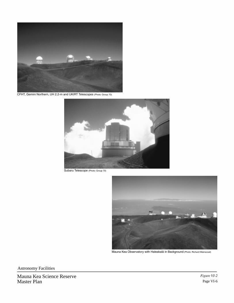
CFHT, Gemini Northern, UH 2.2-m and UKIRT Telescopes (Photo: Group 70)
Mauna Kea Observatory with Haleakalä in Background (Photo: Richard Wainscoat)
Subaru Telescope (Photo: Group 70)
Mauna Kea Science ReserveMaster Plan
Figure VI-2
Page VI-6
Astronomy Facilities
Mauna Kea Science Reserve Master Plan
Education and Research Page VI - 7
The Keck Interferometer will search for planets beyond our solar system. Because evennearby stars are far away, and because planets are much smaller and fainter than stars,powerful telescopes are needed. In the last few years, astronomers have observeddefinitive signs of planets in other solar systems, however, no direct images have beenproduced. Rather, scientists have observed the effects of the gravitational pull between astar and neighboring planet. The NASA’s Origins program seeks to capture directimages of Earth-like planets, if they exist, and study their planetary atmospheres in aneffort to determine whether life exists on other worlds. Combining the images throughinterferometry will vastly improve the ability to distinguish the faint motion of twodistant objects, such as a star and a planet, that are actually very close to each other inspace.
Support Facilities
Hale Pöhaku TodayToday Hale Pöhaku continues to serve as the main base for astronomers and technicians.Sleeping accommodations are provided in 72 units, designed with blackout shades andother accommodations tailored to daytime sleepers. Astronomers, technicians andsupport staff gather in the common building which includes a kitchen, dining area,lounges, offices and a library. A maintenance area serves as a headquarters for MaunaKea Support Services (MKSS) repair and maintenance activities. MKSS staff at HalePöhaku include 12 persons supporting food and lodging and 5 persons in the utility area.The latter perform road maintenance, snow removal and facility maintenance at HalePöhaku.
Over time, the use of the mid-level facilities has changed. At one time they were oftenfilled to capacity with visiting astronomers and construction crews. Technologicaladvances have made remote viewing a practical alternative to working at the summit andastronomers do not necessarily need to be at the summit to analyze data collected at someof the observatories. The W. M. Keck Observatory, for example, has designed itsWaimea headquarters with control rooms linked with data and video lines to theobservatory on Mauna Kea. Astronomers using the Keck facilities can stay in the Keckdorms in Waimea and perform their work without traveling to the mountain. The VLBAis operated remotely from the VLBA headquarters in New Mexico. It can be expectedthat, over time, more and more astronomers will be able to obtain their data withoutgoing to the summit of Mauna Kea and perhaps even without coming to Hawaiÿi. As aresult, the lodging facilities at Hale Pöhaku may experience less demand from theastronomy community.
Currently, the facilities at Hale Pöhaku average 3,400 reservations a year (Koehler,1999). On average, 34 of the 72 rooms are occupied. During special astronomicalevents, such as an eclipse or comet collisions with Jupiter, the facilities are often full.Demand also increases when significant milestones are achieved in telescopedevelopment. For example, most of the lodging units were occupied with first lightpreparations for Gemini and Subaru telescopes in early 1999.

Mauna Kea Science Reserve Master Plan
Education and Research Page VI - 8
Base Support FacilitiesThe development of the astronomy facilities on Hawaiÿi extended from the top of MaunaKea to the island’s coast. While telescopes are constructed on top of the mountain, andcommon facilities provided in the mid-elevation area, base facilities have been developedin Hilo and Waimea. Built in population centers, base facilities for each observatory arelocated near the workforce, in comfortable climates, and near business, schools, andhousing. Typically, these base facilities contain offices, laboratories, and computerfacilities to support the observations on the mountain. While most base facilities arelocated in Hilo, the W.M. Keck Observatory and Canada-France-Hawaiÿi Telescope havechosen to located their headquarters in Waimea. Mauna Kea Support Services (MKSS),the organization responsible for the food and lodging accommodations and roadmaintenance on Mauna Kea, also has a base facility in Hilo.
InfrastructureThe sophisticated astronomy complex atop Mauna Kea is supported by an infrastructuresystem designed to meet state of the art communication needs, address personal safetyconcerns, and impact the natural environment as little as possible while accomplishingthese goals.
Over time, the roadways and other infrastructure systems have been improved to providesafer and more efficient service to the astronomy facilities. As mentioned above, theoriginal jeep road to the summit built in 1964 was improved for safety purposes in 1975.The gravel road that served the summit for the next decade was better, however, it stillwas dusty, which interferes with observations, and can be unsafe for vehicles.
In 1985, funded by State funds and the Keck Observatory’s infrastructure contribution,the State Department of Transportation began the design process for a 20-foot wideroadway beginning at Hale Pöhaku and looping around summit facilities. To date, two ofthe six phases of construction have been completed, including pavement of the roadwayfrom the 11,800 elevation to the summit facilities. When funding is available, futurephases will include the paving of the road from Hale Pöhaku to 11,800 feet, constructionof additional parking areas, and two runaway truck ramps.
Water for Hale Pöhaku and the summit is regularly trucked from Hilo. Two-40,000gallon water tanks are located at Hale Pöhaku. Currently, 25,000 gallons per week aretrucked to the Mid-Level Facility. An additional 15,000 gallons per week are trucked tothe summit to supply the various observatories. These quantities have remained fairlyconstant throughout the development of the telescope facilities. However, during heavyconstruction periods additional water is consumed by the construction crews.
All sewer disposal and treatment is handled by individual cesspools and septictank/leaching field systems that serve each facility. All existing facilities have beenapproved by the State Department of Health. There is no plan to construct a sewersystem to collect and treat wastewater from each facility.

Mauna Kea Science Reserve Master Plan
Education and Research Page VI - 9
During the early years of telescope development, power was provided to individualfacilities by on-site generators. The first phase of bringing power lines to the summitbegan in 1985 with the construction of a 69KV overhead system from the HumuÿulaRadio Site to a substation located just below the mid-level facilities. There, the voltage isreduced to 12.47KV, and the power distributed via underground distribution system tothe summit. The initial construction of the distribution system was completed in 1988.In 1995, the electrical system was upgraded to complete the loop at the summit andprovide service to the Submillimeter Array.
Development of the communications system required many phases of construction tocomplete. The first phase began during the construction of the underground powerdistribution system in 1985. The addition of summit communications system continuedinto the 1990’s, with the installation of fiber optic lines.
A project to add fiber optic lines to the existing 69KV overhead power system began in1995. The lines were added to the existing system of poles from the Humuÿula RadioSite to the substation near Hale Pöhaku. In 1996, the construction began on the finalphase of the fiber optics communication system, which completed the linking of all thetelescope facilities and the mid-elevation support facilities.
Other Research and Education
The first research activities on Mauna Kea are documented in the journals of some of theearly explorers of the mountain. The first confirmed ascent of Mauna Kea by a foreignerwas made in 1823 by Joseph Goodrich. Botanist David Douglas scaled the mountainsummit in 1831. Like Goodrich, Douglas made observations of the summit cinder conesand desolate landscape. In 1892 W.D. Alexander led a surveying party to Mauna Kea.They spent time on the summit of Lïlïnoe and made observations of stone cairns andunique land forms. On one of the summit cones, they found a tin can that containedrecords of five different parties that had visited between 1870 and 1892 (in McCoy,1999). In 1937, Gregory and Wentworth wrote of the evidence of Mauna Kea’sglaciation, describing the character of the bedrock that has been shattered and shaped bythe glacial ice.
Explorers, educators, and scientists have long appreciated the unique natural and culturalfeatures of Mauna Kea. The development of a road to the summit provided vehicularaccess to the region’s rich resources that had not been available before. Some of the firstformal archaeology surveys took place in the Natural Area Reserve and Science Reservein the mid 1970s.
Much of the detailed archaeological and scientific research was conducted as part of thecomprehensive planning process for the Science Reserve in the early 1980s. Botanicalstudies and arthropod studies were conducted of the summit area. During this time thefirst discovery of the Wëkiu bug was made. Archaeological surveys of the summit
Mauna Kea Science Reserve Master Plan
Education and Research Page VI - 10
identified shrines and workshops that tell the story of the mountain’s earliest use by man.Biological and archaeological surveys of the Hale Pöhaku area were also undertaken inthe early 1980s.
With the development of the astronomy complex has come a wealth of educationaloutreach programs. Thousands of high school and elementary students each year receivean introduction to astronomy’s wonders through field trips to the mid-elevation facilitiesand through contact with the scientists and educators from the various observatories.University professors take their students to the mountain to study astronomy, geology andclimatic processes, and Hawaiian culture and language.
Up to the present time, education and research activities have focused largely onastronomy. Other research activities have resulted largely from astronomy planningefforts. However, there is great potential for much broader educational and research useon Mauna Kea independent of astronomy activities. There is a sentiment amongeducators that non-astronomy education should be encouraged and promoted. So, inaddition to programs to train Hawaiÿi’s young people in the science and technology ofastronomy, there is a need for K-12 and remote learning programs statewide, togetherwith learning centers at University of Hawaiÿi at Hilo and Hawaiÿi Community College toprovide balance between science and culture through education.
In a proposal (14 January 1998) for the creation of a management structure, Dr. JamesJuvik, Ph.D., lists some of the research projects undertaken by University of Hawaiÿi-Hilo faculty as examples of the many areas of study that can be supported and enhancedthrough use of Mauna Kea as a laboratory and classroom. Among the many possibilitiesis study of Hawaiian culture and archaeology, high altitude atmospheric research, earthprocesses and quaternary studies, montane terrestrial ecology, and human biology andresponse to high altitude.
Currently the University of Hawaiÿi at Hilo is working with NASA and the BishopMuseum to develop the Mauna Kea Astronomy Education Center. This facility will beconstructed in University Park and will serve as a science and education resource forastronomers, students of all ages, and the general public. Plans for the Center willinclude a planetarium and theater, displays of astronomy, natural history, cultural history,classrooms and laboratories, distance learning facilities, and visitor amenities. Thepurposes of the Education Center are multi-faceted. The complete proposal for theCenter can be found in Appendix B; and an excerpt is presented below.
(Excerpt from the UH-Hilo Proposal for the Mauna Kea Astronomy Education Center)
“Education, with an emphasis on outreach to indigenous community members, isa central feature of the Master Plan. Much of the philosophical framework forthis finds expression in the proposed Mauna Kea Astronomy Education Center atthe University of Hawaiÿi at Hilo. The Center will serve to facilitate formalastronomy education and the integration of science into indigenous cultures at all
Mauna Kea Science Reserve Master Plan
Education and Research Page VI - 11
levels. It also will serve as the principal center in the world demonstrating howthe latest science can be integrated with indigenous cultures of great antiquity tomaintain unique cultural identity and knowledge while participating at thescientific forefront of the international global society. The Center will help totrain the next generation of space scientists and to raise the overall level ofscience literacy in our nation. Students, teachers and college instructors, andcommunity college/ baccalaureate students locally, nationally, and worldwide.Programs to support formal astronomy education will include:
� School class visitation programs, for visiting school groups from Hawaiÿi andthroughout the world, utilizing all the Center observatory visitor facilities andsome of the academic support facilities.
� Professional development experiences for teachers and college instructors inthe forms of year-round workshops, on-site and distance learning courses andprograms, curriculum development, and research opportunities incollaboration with University of Hawaiÿi astronomy faculty.
� Enhancement of classroom astronomy instruction throughout the State ofHawaiÿi by in-class programs presented by Center staff and affiliatedUniversity of Hawaiÿi astronomy pre-service education students.
� Collaborative use of Mauna Kea telescopes to enhance astronomy instructionin cooperating community colleges, universities, and K-12 schools, locally,nationally and world-wide.
� Summer astronomy workshops and courses for astronomy students fromsecondary schools, community colleges, and universities using the Center’sfacilities and the Mauna Kea observatories.
� Electronic dissemination of scientific data from Mauna Kea telescopes andlive images, to schools and universities world-wide.
� Development of a national Astronomy Scholars Program in conjunction withthe University of Hawaiÿi at Hilo.
� Year-round Hawaiian and indigenous culture workshops.
� Development of curriculum materials on Hawaiian and indigenous cultures.
� Academic programs in Hawaiian and other indigenous languages and culturesat the community college, baccalaureate and graduate levels.”

MAUNA KEA SCIENCE RESERVE MASTER PLAN
VII. RECREATION

Mauna Kea Science Reserve Master PlanRecreation Page VII - 1
RECREATION
Enjoying Mauna Kea’s Unique Natural Resources
Before the first road to the summit was built in 1964, only hardy recreationalists hikedMauna Kea’s slopes. During this time, hunters were active on the mountain’s lowerslopes. Stone cabins built by the Civilian Conservation Corps (CCC) in the 1930s servedas the base camp for hunters, hikers, and explorers. The name of the mid-elevation area,Hale Pöhaku, derives from these cabins.
Ever since the first road was developed to the summit, people have come to Mauna Keato hike, play in the snow and sightsee. Hunting is also an important activity which maybe viewed as recreation but for many is an integral part of their lifestyle, subsistence andculture. Hunting continues to occur at the lower elevations of the mountain outside theScience Reserve.
Residents and visitors alike come to Mauna Kea simply to experience this place that isunlike any other in Hawaiÿi. Many are drawn to the mountain to witness the world classtelescopes, feel the chill of the air, and appreciate the desolate beauty and natural landforms of Mauna Kea. What they must also keep in mind is that the extreme weatherconditions on the mountain make all recreational activities potentially dangerous.
Hiking
Hikers visit Mauna Kea for an experience that is unmatched in the Hawaiian Islands. Theclear skies, cool air, and awe-inspiring landscape draw experienced and novice hikersalike. The factors that make Mauna Kea such a uniquely appealing place to hike are alsocause for health and safety concerns. Hikers must be prepared for the affects of highaltitude on their bodies and the possibility of a sudden and severe change in weather.
Hiking is most popular in the Ice Age Natural Area Reserve and along existing roads.Individuals typically drive up the mountain for a distance before parking and hiking. TheHumuÿula-Mauna Kea trail runs from the old sheep station at Humuÿula to Waiÿau. A fewindividuals brave the low temperatures and swim in Waiÿau.
Snow Play
Big Island residents and visitors look forward to those winter periods when snow falls atthe higher elevations of Mauna Kea. Families and individuals visit the mountain to ski,snowboard, and play in the snow. Often, people load their pickup trucks with snow totake down to Hilo and other towns so that others can enjoy the snow.

Mauna Kea Science Reserve Master PlanRecreation Page VII - 2
The Summit Access Road is kept clear of snow by Mauna Kea Support Services staff.Private vehicles typically park along the roadways and visitors play nearby. The mostpopular ski and snowplay areas are those easily accessed by roadways. The ski runknown as Poi Bowl is the most popular because it is accessible by roads at both the topand bottom of the run. Skiers typically establish an informal shuttle system where theskier is dropped off at the top of the run and then met at the bottom. If the snowfall isheavy enough, the area to the east of the summit, known as King Kamehameha run, isused for longer ski runs although the bottom of the run is not accessible by vehicle andthe skier must hike back to a roadway. At times it is possible to ski from the summit tothe edge of the Science Reserve. Once or twice a year, depending on the snowconditions, a skiing or snowboarding competition is held on the mountain. Popular skiareas are shown in Figure IX-25.
The weather patterns for any particular year will determine how much and where snowfalls. Snow typically falls first and melts last from the northern slope of Puÿu Hau Kea(also known as Goodrich). At times it is the only place on the mountain with snow.When snowfall is light, people tend to hike between snowy areas.
Sightseeing and Stargazing
Sightseeing is another favorite activity for residents and visitors alike. Before proceedingup the mountain visitors are asked to spend time at the Visitor Information Station (VIS)to view the exhibits and acclimate to the altitude. A number of visitors use privatevehicles to explore the summit on their own. Visitors will drive up to the summit possiblystopping along the way to walk around a bit and take photographs. At the summit, thepublic can visit the Keck Visitor Gallery to view exhibits and see the inside of one of theKeck domes. Other visitors will join MKSS-led tours twice a week. In 1998, anestimated 38 visitor vehicles traveled to the summit of Mauna Kea daily (Koehler, 1999).Another 100 to 150 vehicles visited the VIS only each week. Approximately 100students visit the VIS each month during the school year and even more visit in thesummer months.
While many residents and visitors drive to the summit area themselves, others joincommercial tours. DLNR issues a limited number of Commercial Activity Permits totour operators who pay annual and per customer fees. Commercial tours register at HalePöhaku each time they ascend the mountain. In 1999, eleven Commercial ActivityPermits were active (Unoki, 1999). Of these, ten allowed tours to the summit and oneprovided commercial access to Hale Pöhaku only. Tour operators take visitors for six toeight hour trips which can include an observatory tour, lunch, hikes to Waiÿau, andnarratives on the area vegetation and natural history. In the Fall of 1998, an estimated 30tours per week went to the summit (Koehler, 1998).
Taking sightseeing to a higher level, the MKSS offers stargazing programs at the VisitorInformation Station seven evenings a week. These stargazing programs drew an averageof 80 participants per evening (320/week) in 1998 (Koehler, 1998).

Mauna Kea Science Reserve Master PlanRecreation Page VII - 3
The same factors that make Mauna Kea a premier spot for major astronomy research alsoprovide excellent conditions for amateur astronomy. Many of the evening visitors to themountain, especially the VIS area, are amateur astronomers.
Hunting
Long a tradition on the island, hunting continues on Mauna Kea in a managed structure.Hunting on Mauna Kea occurs largely outside of the Science Reserve on the mountain’slower slopes. Today, pigs, sheep, goats, and a variety of gamebirds are hunted by rifle orarchery in three dozen hunting units concentrated in the central portion of the Island ofHawaiÿi (Figure VII-1).
Lloyd Case, interviewed in Kepä Maly’s oral history study for Mauna Kea, describeshunting with his family on Mauna Kea.
“I started going hunting with my brothers, from five years old, I went outseveral times. Then later on, from eight years old to ten, I started goingmore and more with my brothers. But Mauna Kea was one of ourparticular areas that we liked to hunt. One of our favorite places becauseit had a variety of game. You could go there and get your puaÿa (pig), youcould get your hipa (sheep), there were goats in those days too. But ourfamily, we grew up on sheep, so Mauna Kea was a place that I alwayswent to gather sheep.” (p. A-345 in Maly, 1999)
“What we used to do is, we’d sleep right there, and in the morning, thesheep would come down for eat. So what we would do is go right aboveand wait for them to come back up.” . . . “They come down to eat. Sowhat we’d do is walk up a little bit and intercept them on their way backup. And it’s all down hill then, so we’d pack ‘em right down to the roadyeah.” (p. A-345 in Maly, 1999)
Gamebirds including turkey, pheasants, quails, chukars, and francolins are also presenton Mauna Kea’s slopes. There are over 3,000 licensed hunters living on the island. TheMauna Kea Forest Reserve (elevations over 7,000 feet) is a hunting unit where pigs,goats, sheep and birds can be hunted with archery and firearms. Sport hunting is apopular activity which contributes to the island’s economy. While sheep, goats, pigs andsome game bird species sometimes enter the Science Reserve area, most of the birds andmammals are hunted on the mountain’s lower slopes.

Mauna Kea Science ReserveMaster Plan
Figure VII-1Page VII-4
0' 7500' 15000' 30000' NORTH
AC
CE
SS
RO
AD
S A D D L E R O A D
SUMMITNAR
HuntingUnit A
HuntingUnit G
HuntingUnit E
HuntingUnit E
HuntingUnit F
Unit E Unit B
Unit D
Mauna KeaScience Reserve
Hale Pöhaku
Mauna KeaIce Age
Natural AreaReserve
Source: Saddle Road (SR 200) Mamalahoa Highway (SR 190) to Milepost 6DEIS, Techinical Appendices, Volume V, 1997
DLNR Hunting Units
,:x ,/
-,, ,r--
,v~ ./ - \ \ __ '::;\
_;--- 'j -,_ .

i
MAUNA KEA SCIENCE RESERVE MASTER PLAN
VIII. ISSUES AND OPPORTUNITIES

Mauna Kea Science Reserve Master PlanIssues and Opportunities Page VIII - 1
ISSUES AND OPPORTUNITIES
Management and use issues are not new to Mauna Kea. Soon after the introduction ofthe first cattle, goats and sheep, these animals roamed the slopes of the mountain,contributing to the decline of vegetation in the palila habitat. Wildfire has also been asource of habitat destruction. Hunting was and is an important way of life for manyHawaiÿi Island residents; however, even the hunters could not keep pace with the rapidlygrowing animal population. In destroying portions of the mämane-naio forest, theanimals impacted the only habitat of the palila bird. Territorial and State governmentagencies have attempted to control the population of ungulates through formal huntingefforts. However, the long-standing issue of balancing habitat protection and huntingtraditions exists to this day.
With the development of the astronomy facilities and supporting infrastructure on MaunaKea in the late 1960s, access to the summit area increased and the number and types ofmountain users multiplied. As a response to user conflicts and concerns regarding thenatural and cultural resources of the mountain, several management and planning effortswere undertaken.
In 1968, the Board of Land and Natural Resources approved a 65 year lease (GeneralLease No. S-4191; January 1, 1968 to December 31, 2033) to the University of Hawaiÿifor a 13,321-acre circular area (2.5 miles in radius) centered on the Mauna Kea summit(approximately all the lands above 12,000 feet elevation) and referred to this land as theMauna Kea Science Reserve (Land ownership is presented in Figure VIII-1). As statedin the Lease: “The land hereby leased shall be used by the Lessee as a scientific complex,including without limitation thereof an observatory, and as a scientific reserve beingmore specifically a buffer zone to prevent the intrusion of activities inimical to saidscientific complex.”
Most of the broad responsibilities of the University of Hawaiÿi stem from this Lease:
1. Maintenance of the premises in a clean and orderly fashion.2. The right to develop improvements upon review and approval by the BLNR.3. General liability resulting from negligence of UH.4. Compliance with DLNR regulations and all other federal, state and county laws
affecting land or improvements.5. UH must not damage any cultural or historic site of value.6. No planting of trees, shrubs or other vegetation except those approved by the
Chairman of BLNR.
In addition to the general retention of regulatory authority, the BLNR specificallyidentified and retained all water rights, rights to access through the Science Reserve,hunting/recreation rights, rights to use any part of the Science Reserve or permit anotherparty to use parts of the Science Reserve with the mutual consent of the University.

Mauna Kea Science ReserveMaster Plan
Figure VIII - 1
Page VIII - 2
Source: City and County of Honolulu,Real Property Assessment Division
Tax Maps Branch, 12/31/98
Land Ownership MapNORTH0' 7500' 15000' 30000'

Mauna Kea Science Reserve Master PlanIssues and Opportunities Page VIII - 3
1970s Planning
As astronomy development expanded in the early 1970s, concerns about further telescopedevelopments were raised by hunters and conservationists. It was generally recognizedthat an overall Mauna Kea plan was necessary in order to control development on themountain and to resolve the conflicting interests of the various users. Recognizing theincreased scientific and recreational activity on Mauna Kea and expressing concern fornative Hawaiian ecosystems, Acting Governor George Ariyoshi directed the Board ofLand and Natural Resources to develop a master plan for all of Mauna Kea. DLNRinitiated the planning study in 1975 and The Mauna Kea Plan was approved by theBLNR and published in 1977. The plan provides a policy framework for themanagement of the mountain from the Saddle Road area at 6,000 feet to the summit(DLNR, 1977).
The plan identified areas of responsibility for DLNR, the University of Hawaiÿi and theState Department of Transportation. According to the plan, the University is responsiblefor management and upkeep of Hale Pöhaku area astronomy facilities and managementand upkeep of Mauna Kea Science Reserve.
All other management functions were retained by DLNR except for control of theSummit Access Road which was designated for the State Department of Transportation.
The 1977 Plan established five management areas and described acceptable use andmanagement controls for each area (Figure VIII-2).
1. Mämane-naio Forest Ecosystem Management Area2. Science Reserve Management Area3. Special Natural Area and Historic/Archaeological Management Area4. Silversword Management Area5. Military Management Area
1980s Planning
During the initial years of increased astronomy support activity at Hale Pöhaku, othermountain users expressed concern about that area’s development. Hunters worried aboutthe potential loss in the size of the hunting range. Environmentalists expressed concernthat the palila habitat would be damaged by new construction. Recreational users askedthat park facilities be included for public use.
Recognizing the concerns raised by various interest groups, and a need to replacetemporary structures with permanent astronomy support facilities, the Hale PöhakuComplex Development Plan was prepared by Group 70 in 1980. The reportrecommended specific siting, organization, and general characteristics of the permanentfacilities proposed for Hale Pöhaku in support of the six telescopes developed on thesummit at that time. The CDP also provided design guidelines which call for minimized

.... \ _.,,-.,;, / : ... .. ........... -, .... _; ,-.. -~~ .. .'_....:_· -·--;\-- ··; .. :_ .. ;,:,;.':'----·.....;:..,,w..=-.e - ..:c~~ ..... ~ ,q,;,,-,
- I . ,' > · .. :.:<_~.:~ J; ,l_r'1,-- ._,_~;:=.·_ij_._·_~~--.:j;_-··11":~i,,~ (.,· . , .-... ,,, _~ · ,···r -~-.. , .. -··.- .... •-,.:,,....... -.
t ~~./,}lf, ... ' , \ ·~ \ ... , ,. W, .· h-t ' ~ = '';i;::~:~:i il" -. . •. . . , · -·-i '- : _ Q i " ' .• = .. ./ ~ .t (. ' ' : (.~~ ,,'/' . --··:;:-:;-:-:..··:~:_·-:··~ ··-, ··.
,_';;r , ,,::;-~~ \\_ .r, ✓ , -~--.: -.:, ~-- /--~~..,-:-- 1a~~i~~@~~1i~~~~~~~~2~~~~~~~;J · :- \ j ,. ... :· ..... ·
lf'::P ........ ___,,e--------,,....._., ....... ~ ,-""'~ . ,
•
I
_l_N_r~r--+l~_N __ . ✓ G~~ __ 1\. R E A
S ; ,R.V .~ TIO N )
Mamane • Naio and Associated Ecosystem
Natural Area Reserve
Silversword Area
-~ E3
1977 Mauna Kea Plan Management Areas
Mauna Kea Science Reserve Master Plan
Military Area
,I I_· ~ . \
Palila Critical Habitat
Forest Reserve Boundary
Source: The Mauna Kea Plan Hawai'i Department of Land
and Natural Resources, 19n
Science Reserve
a ___ 1~500_ • __ 1_sooo ...... _· ____ J_oooo_ · ~
Figure VIII • 2
PagcVill - 4
Mauna Kea Science Reserve Master PlanIssues and Opportunities Page VIII - 5
disturbance of the mämane-naio ecosystem and integration of facilities into thelandscape. These guidelines were followed in the development of the main food andlodging complex. These facilities are built on pier type foundations following the naturalterrain. Building colors blend into the landscape and surfaces are designed to be onlyminimally reflective. The entire complex was designed to incorporate the area’svegetation with minimum disturbance of the mämane-naio ecosystem.
In an administrative action that occurred during this time, Executive Order No.3101 datedNovember 16, 1981 identified two Natural Area Reserve parcels to be set aside from theScience Reserve and placed under the management of the DLNR. Parcel 1 was a1,889.7-acre pie-shaped parcel encompassing much of the adze quarry and Waiÿau andthe other was a 143.5-acre rectangular parcel surrounding Puÿu Pöhaku. The formalwithdrawal of the parcels from the general lease occurred on March 23, 1998. Theseactions removed the University from responsibility for management of these areas.
While the Hale Pöhaku facilities were being constructed, the University of Hawaiÿi wasalso looking towards the future of ground-based astronomy at Mauna Kea. TheUniversity of Hawaiÿi Research Development Plan (RDP) was adopted by the UH Boardof Regents in 1982. The RDP provided the programmatic basis for the continueddevelopment of the Science Reserve and Hale Pöhaku with the goal of developing a pre-eminent state, national, and international resource for astronomical observations. TheResearch Development Plan called for future development of telescopes, infrastructureimprovements and expansion of the mid-elevation facilities at Hale Pöhaku to supportproposed telescope development.
The Mauna Kea Science Reserve Complex Development Plan (CDP) (1983) wasprepared by Group 70 to provide the physical planning framework and managementguidelines necessary to implement the UH Research Development Plan. The CDP servesas a guide for development which preserves the scientific, physical and environmentalintegrity of the mountain. It also provides proposals for managing the mountain’sresources and visitor use. During this planning effort, the summit’s biological andarchaeological features were scientifically documented for the first time. Extensive floraand fauna studies, in addition to further archaeological work, were undertaken. As aresult of the analysis of this information, a mixed use plan was developed for the summitand mid-elevation areas.
In the plan, areas of the summit plateau above 13,000 were analyzed using scientific,natural resource, and cultural resource criteria. Areas selected for potential facilitydevelopment met scientific wind turbulence and obscuration requirements, were in areaswhere the ground was suited for construction, and where the impacts to recreational uses,visibility, biological resources, and archaeological sites would be minimized. The sevenareas (Figure VIII-3) initially analyzed were refined to four planning areas toaccommodate development of appropriate proposals through the end of the 1990’s. Theplan specifically identified proposed new telescopes which became the facilities nowknown as CSO, JCMT, and Keck I. It also envisioned proposals for additional

25' Contour Intervals
Reserve Natural Area
S·t· g Areas Telescope I in
Analysis Area Siting (1983) s for Telescope
Kea Science Reserve Mauna Master Plan
--------- Page VIII - 6
3~~ 1500'
=17
C5
o~·=~~::=:::::=.=.=.~F.=igure VIII -3

Mauna Kea Science Reserve Master PlanIssues and Opportunities Page VIII - 7
optical/infrared and millimeter telescopes. In addition to defining four siting areas andsupporting infrastructure requirements, the plan called for parking, trash, and toiletfacilities at the summit to support recreational users of the mountain. This plan alsocalled for the expansion of the Hale Pöhaku facilities to accommodate the new astronomyfacilities proposed for the summit. The plan called for these facilities to be consistentwith the mid-level facilities that had just opened. One new dormitory was subsequentlydeveloped.
Much of the 1983 plan has been implemented. The astronomy facilities that wereprojected have been realized. Policies were laid out for non-astronomy research andeducational use for the mountain. Guidelines were established for such activities ascommercial use and off-road vehicles.
The plan encouraged the University to hold open nights at the Visitor Information Stationto share astronomy with the public. Today, the MKSS sponsors star-gazing programsseven nights a week. With respect to infrastructure, the plan called for the paving of theentire road from Hale Pöhaku to the summit. To date, the upper half (approximately 4miles) of the road has been paved with further work awaiting funding.
While much of the 1983 plan was carried out, a number of the plan’s recommendationshave not been implemented. For example, the plan recommended that rangers be hired topatrol the mountain and, in fact, the Institute for Astronomy established these jobpositions at one time. However, the unfilled position were eliminated during budget cutsthat affected all University programs.
With respect to recreational uses, the plan called for visitor parking and trash facilities inthe summit area, and established enforcement guidelines aimed at encouraging visitors touse the designated parking areas. Other facilities proposed in the plan included amultipurpose research laboratory in the summit area and a permanently installedtelescope for visitor use in the Hale Pöhaku area. These facilities have not beendeveloped.
In an effort to remedy the difficulties caused by multiple jurisdictions, the plan called forthe establishment of a management committee that would be advisory to the Departmentof Land and Natural Resources and the University of Hawaiÿi. This committee has neverbeen formed.
1990s Planning
In 1995, a joint revised management plan was adopted by the University of Hawaiÿi andthe DLNR. This plan clarifies and redefines the rights and responsibilities of the twoorganizations in the Science Reserve. The UH retained the following rights andresponsibilities:

Mauna Kea Science Reserve Master PlanIssues and Opportunities Page VIII - 8
1. Mauna Kea Science Reserve Access:
• The right to control, maintain and manage access in the Science Reserve;including the Access Road and associated parking areas.
• The right to limit vehicle type or impose driving requirements.• The right to restrict hours of access.• The right to close the road for maintenance, hazards, snow removal or road
repairs.• The right to ask others to assist in crowd control (similar to deputizing).• The right to require liability waivers.• The right to comment on commercial permit applications.• The right to control visitor activities around astronomy facilities.• The right to limit commercial vehicles in the Science Reserve.
2. Activities at Hale Pöhaku Visitor Information Station:
• The right to limit 14 passenger commercial vehicles.• The authority to enforce rules and institute crowd control policies at the
Visitor Information Station.• Authority to set the hours of operation at the Visitor Station.• The right to issue special permits for the use of the Visitor Station.
3. Commercial Activities at UH Facilities:
• The right to operate concessions.• The right to contract for shuttle service to the summit.
Approval of this management plan came with several conditions. The followingidentifies major or special responsibilities of the University:
1. Historic Preservation Plan to be completed and implemented by UH IfA.2. This management plan replaces the plan identified in CDUA HA-1573.3. Include cultural uses that do not involve physical impacts.4. MKSS (Mauna Kea Support Services) staff be educated and instructed to report
violations of the Mauna Kea Plan.5. Additional specifications on protection of historic sites intentionally or otherwise.6. Reporting back to the BLNR after the completion of archaeological and biological
studies to review possible needs for change.7. Additional signage for various purposes.8. 7 day a week Visitor Station hours and DOCARE for Mauna Kea (not exclusive),
subject to funding.

Mauna Kea Science Reserve Master PlanIssues and Opportunities Page VIII - 9
Under the current conditions, DLNR retains the following responsibilities:
1. Authority to determine permitted public and commercial uses of the UHmanagement areas (Science Reserve, Access Road, Hale Pöhaku).
2. Authority over recreational uses and commercial tours within the ScienceReserve.
3. Authority over research and education, natural resources, historical and culturalresources, recreation, and commercial use on State land, including the NaturalArea Reserve.
4. Statutory responsibility for treatment of historic sites.5. The responsibility to make sure commercial permits have consistent fees, set
terms and are subject to review and renewal by DLNR. These permits may besuperceded by Land Division permits in the future.
These existing management responsibilities, based on the latest plans and statutoryrequirements are depicted in Table VIII-1.
Auditor’s ReportIn 1997, the State Legislature, through Senate Concurrent Resolution No. 109, requestedthat the State Auditor conduct an audit of the management of the mountain. TheAuditor’s report was issued in February 1998 as Report No. 98-6. Both the University ofHawaiÿi and the Department of Land and Natural Resources were criticized in the reportwhich concluded that new technology impacted development of the Science Reserve andmanagement of the summit area did not adequately protect cultural and natural resources.The audit concluded with the following recommendations to address issues raised in thereport:
Management• Develop rules and regulations for summit area and Hale Pöhaku• Hire ranger/guides at Hale Pöhaku who will be there on a daily basis• Require registration of visitors for education and safety reasons• Develop milestones, specific timeframes & other controls to ensure implementation• Develop a forum for continuous community input• New method for measuring impact• Measure impacts individually and cumulatively• State specific carrying capacity• Require management plans that have time frames• Ensure internal deadlines prior to release of land or leases.• Make sure all responsibilities are assigned; either UH or DLNR
Historic/Cultural Resources• Address cultural and historic issues• Complete the Historic Preservation Plan

Science Reserve State Land Responsibility (Includes Summit Road) Hale Pöhaku (Includes NAR)
Research/EducationAstronomy UH UH DLNROther Disciplines UH UH DLNRPublic Education --- UH ---
Natural ResourcesIce age/Periglacial DLNR/UH --- DLNRWekiu Habitat DLNR/UH --- DLNRPalila Habitat --- DLNR/UH DLNREndangered Species --- DLNR/UH DLNRFeral Ungulates DLNR DLNR/UH DLNRAlien Species DLNR/UH DLNR/UH DLNREcosystem Restoration DLNR/UH DLNR/UH DLNR
Historic Sites DLNR/UH DLNR/UH DLNRBurials DLNR-BC/UH DLNR-BC/UH DLNR-BCCultural Practices DLNR/UH DLNR/UH DLNR
RecreationSkiing and Snow Play DLNR --- ---Hiking DLNR DLNR/UH DLNRCamping --- DLNR/UH DLNRSightseeing/FIT Tourism --- DLNR/UH DLNRHunting DLNR DLNR DLNROther Recreation DLNR/UH DLNR/UH DLNR
Commercial UsesTours DLNR DLNR DLNRConcessions DLNR/UH DLNR/UH DLNRMovies/Commercials DLNR DLNR DLNRCabin/room accommodations --- UH ---
AccessSummit Road UH UH UHTrails DLNR/UH DLNR/UH DLNR
Safety and SecurityRoad Conditions (above HP) --- UH* UHDangerous Weather --- UH* ---Altitude Education --- UH* ---Medical Emergencies UH/CTY UH/CTY CTYFire UH/CTY UH/CTY CTYCrime CTY CTY CTY
MaintenanceRoad (above HP) --- --- IfAUtilities UH/Utilities UH/Utilities UH/UtilitiesTrash Removal UH UH DLNRRemoval of Old equipment UH UHGraffiti UH UH DLNR
Community ParticipationPublic Restrooms Keck* UH ---Programs --- UH ---Notification UH UH ---
--- = None or not applicable UH = University of Hawaiÿi at Manoa (Includes IfA) BC = Burial Council * = Done but not required DLNR has rights to authorize other uses of the Science Reserve as long as it does not interfere with lease conditions
Historical and Cultural Resources
EXISTING AUTHORITYTable VIII-1 MAUNA KEA RESPONSIBILITY MATRIX

Mauna Kea Science Reserve Master PlanIssues and Opportunities Page VIII - 11
Maintenance• Periodic inspection and documentation of trash control• Remove remnants of old equipment
Physical Planning Guidance• Identify areas suitable for astronomical development• Identify critical habitats for plants, invertebrates and other endangered species• Identify no build zones• Include facilities besides telescopes.
Statutory Recommendations/Lease Agreements• Incorporate EIS mitigation measures as CDUA conditions• Relate permit conditions to leases• Adopt rules for Chapter 6E, Historic Preservation Program.
Planning Today
This Mauna Kea Science Reserve Master Plan will serve to address current concerns andguide the planning for the Mauna Kea Science Reserve for the next 20 years. While theprojections of the 1982 Research Development Plan and 1983 Complex DevelopmentPlan have largely been implemented by 1999 as scheduled (the planning period was tothe year 2000), the goals of balanced use and protection of resources have not been fullyachieved. Issues and opportunities for the future use and management of the mountainbeyond 2000 are explored below. Recommendations concerning these issues are detailedin the Physical (Section IX) and Management (Section X) plans that follow.
Management Authority
The joint responsibilities and layers of historical leases, plans, permits and written orverbal commitments have created a complex and often confusing pattern of managementresponsibility.
ISSUES
Unclear Responsibility: The legal and constitutional mandates to variousagencies are articulated in the general lease, Hawaiÿi Revised Statutes and variousplans and permits that have been adopted. Over the years, changes in plans,permits and personnel have resulted in a complex web of responsibility. TableVIII-1 summarizes the major areas of responsibility at the current time. A quickglance at this matrix shows the complexity of the arrangements. DLNR has hadno permanent personnel on the mountain while UH has a number of people. UHIfA also has control and responsibility for the Summit Access Road. Therefore,some assume that UH has had de facto control and responsibility over the wholesummit region even when it has no statutory authority to manage all the resources
Mauna Kea Science Reserve Master PlanIssues and Opportunities Page VIII - 12
and activities in the Science Reserve. Management of the whole summit arearequires management of both the Science Reserve and the Natural Area Reserve.There has been no authority that has been fully responsible for the whole summitarea. As a result, some concerns were not addressed or were only addressed aftermuch delay. This lack of functional clarity has created a situation whichsometimes frustrates the general public because it is unclear to them who canaddress their concerns.
Lack of Confidence in Current Organizations: At the present time DLNR and theUniversity are the key agencies with authority and management responsibilitiesfor the mountain. Both entities will continue to be key stakeholders in all futurescenarios. The problem is the lack of confidence held by some members of thegeneral public in the ability or will of these agencies to protect the natural andcultural resources of the mountain. While some of this lack of confidence is,arguably, a matter of perception rather than fact, there are some realshortcomings. DLNR’s current structure and priorities are not likely to provideimproved management or significant resources to address these shortcomings.IfA, by mission and expertise, is not focussed to provide overall propertymanagement services. Another management structure with the specific charge tomanage the Science Reserve is perceived by many to be an appropriate alternativeto IfA/DLNR management.
Local Control: A commonly held perception on Hawaiÿi Island is that a majorsource of problems is the lack of local control. Decision makers for both IfA andthe DLNR are headquartered in Honolulu. The representatives of IfA whointeract most with the Hawaiÿi Island public are mostly with Mauna Kea SupportServices (MKSS), the organization which provides support services for theobservatories. As service providers, MKSS does not have the authority to speakfor the University. In late 1998, the IfA began construction of a Hawaiÿi Islandheadquarters building in University Park at UH Hilo.
The DLNR has offices for the Division of Forestry and Wildlife, State HistoricPreservation Division, and the Land Division in Hilo but these offices often donot have the authority or resources to respond to the concerns that are raisedregarding Mauna Kea. The lack of decision-making on Hawaiÿi Island makes itdifficult for people to have their concerns addressed in a timely manner. MaunaKea often does not receive the priority or attention it deserves because it mustcompete with other state-wide issues and priorities.
Staff Presence on the Mountain: There are currently no designated rangersstationed in the summit area to educate visitors about the resources and safetyrequirements of the mountain. However, MKSS does have astronomy supportpersonnel on the mountain who are able to provide some of this guidance. Inaddition, a number of IfA and MKSS staff are concentrated at Hale Pöhaku duringthe day. Three ranger positions were once included in the Institute for Astronomy
Mauna Kea Science Reserve Master PlanIssues and Opportunities Page VIII - 13
budget but were cut during University-wide budget reductions in the early 1990s.These positions could have been used to address many of the managementconcerns that subsequently arose. Today, if an IfA or MKSS staff memberwitnesses a vehicle driving off-road or any dangerous activity, he or she will talkto the individual about safety and the rules on the mountain and provideassistance as needed. Litter pick-up also occurs on an ad hoc basis.
Unfunded Mandate: A persistent concern is the lack of adequate funding formanagement of the mountain. The 1983 plan recommended a policy advisorycommittee and baseline studies of natural and cultural resources. These activitieswere either not conducted or late in receiving funding. General lease S-4191 setsconditions for trash clean-up and removal of old facilities. The Auditor’s reportidentified many problems that require changes but did not identify sources offinancing to implement the changes. In any case, management responsibilitiesmust be funded. Potential sources for funding are contributions from astronomyfacilities, appropriations within the University of Hawaiÿi or the Department ofLand and Natural Resources and fees from commercial activities.
Unbalanced Priorities: Some feel that management of the summit area has beenexcessively dominated by astronomy. While official UH policy does not restrictother uses, critics have felt that academic programs outside of IfA have not beensupported. The perceived dominance of astronomy research has evolved into acriticism that cultural and natural resource values and programs, and astronomyeducation programs, have been neglected and that in some cases resources havebeen damaged.
Unmanaged Access: Currently, access is loosely regulated and hardly managed.It has been stated repeatedly that the creation of the Summit Access Road forastronomy opened the summit to general use and potential environmentaldegradation. If the road had not been built, the reasoning goes, the impacts wouldnot have occurred or would have been minimal because the numbers of userswould have been much lower. Additionally, the rise in popularity of off-roadvehicles has increased the potential impacts and conflicts of uses arising fromunrestricted access. Concerns related to access, particularly off-road vehicle use,include destruction of archaeological sites, impacts to sensitive environmentalareas, increase dust, conflicts of use and increased hazards to visitors.
Maintenance: The University and the astronomy community has been criticizedfor creating trash on the mountain and not cleaning it up in a timely manner. Inthe past, construction debris has been scattered in the summit area by high winds.Recently, the University has conducted clean up days to remove this debris.Litter is also left on the mountain by non-astronomy users.
Financial Issues: The Science Reserve is comprised of ceded lands. Some claimthat the Office of Hawaiian Affairs deserves 20% of all revenues. It is also noted

Mauna Kea Science Reserve Master PlanIssues and Opportunities Page VIII - 14
that education is also an equal beneficiary of ceded land revenues under State law.Other charges include the criticism that astronomy facilities are beingundercharged and that the resource (the mountain) is being unfairly exploitedwithout benefits to the broader community.
OPPORTUNITIES
With the Auditor’s report and current planning process, management problemsand concerns have been comprehensively articulated. With the preparation of thisMaster Plan, the University, DLNR, and the community now have the opportunityto redefine management responsibilities and priorities for the Science Reserve.The resulting recommendations are presented in the physical planning guide(Section IX) and management plan (Section X).
Access
ISSUES
Safety: Unmanaged access increases concerns about safety. Hazards in theScience Reserve include accidents in wilderness places, brake failures and loss ofvehicle control on the steep Summit Road, quick changes in weather that couldlead to hypothermia and disorientation, pulmonary edema and variousphysiological problems that could arise from high altitude and reduced oxygenenvironments. Brake failures and vehicular malfunctions are a commonoccurrence in the summit area. These conditions raise potential safety andliability concerns. Over the past few years there have been about six accidentseach year where a vehicle must be towed down the mountain (Koehler, 1998). Inseveral cases, vehicles have run off the road and overturned. People have alsobeen injured while snowboarding and skiing.
Increased Access and Traffic: The Mauna Kea Access Road and Summit AccessRoad are increasingly busy roads used by observatory crews, constructionworkers, cultural practitioners, recreational users, and Mauna Kea SupportServices staff.
Because of the steep grade and sharp turns on the Summit Road, only four-wheel-drive (4WD) vehicles are recommended above Hale Pöhaku. The MKSS-ledsummit tours require that participants drive 4WD vehicles. In the Fall of 1998, anaverage of 560 vehicles per week drove to the summit area (Koehler, 1998). Thefollowing user breakdown is estimated for the period.

Mauna Kea Science Reserve Master PlanIssues and Opportunities Page VIII - 15
Construction Projects(Gemini/Subaru/SMA)
150 per week
Observatory Day Crews 150 per weekObservatory Evening Crews 85 per weekCommercial Tours 30 per weekMKSS Vehicles 20 per weekTourists and Local Traffic 125 per week
Another 100 to 150 vehicles per week visited the Visitor Information Station onlyduring the day and for evening stargazing programs. During the 1999 periods ofsnowfall, it was estimated that over 200 vehicles drove beyond Hale Pöhakuduring the busiest days (Koehler, 1998). Snow removal and road conditionsduring inclement weather are presented in Figure VIII-4. While it isrecommended that only four-wheeled-drive vehicles go above Hale Pöhaku, thereare no staff assigned to prevent two-wheel drive vehicles from using the summitroad.
Beyond permitted vehicular access, individuals occasionally take their vehiclesoff of the paved roads. In seeking their own thrills, these people risk damage toarchaeological sites, arthropod and flora habitats, and to the serenity of the naturallandscape. Prominent signage advises visitors that off-road driving is prohibited.Although there are no permanent barriers preventing vehicles from leaving thesummit access road, access points are blocked with rocks where instances of off-road driving occur.
Improvements to the Saddle Road and further publicity about Mauna Kea’sresources and astronomy complex are likely to increase the number of individualswho visit the mountain. On the other hand, the development of the Mauna KeaEducation Center in Hilo’s University Park may serve to decrease traffic to thesummit of Mauna Kea by providing displays and programs that explore themountain’s astronomical, natural and cultural resources.
OPPORTUNITIES
With the understanding that Mauna Kea will continue to be a popular destinationfor large numbers of people, the opportunity to manage access for the health andsafety of people and the environment is clear. Education can be provided bypersonnel stationed on the mountain and at the Visitor Information Station.Furthermore, education can take place at the Mauna Kea Education Centerproposed for Hilo and in those observatory base facilities which have visitorgalleries.

Mauna Kea Science ReserveMaster Plan
Figure VIII-4
Page VIII-16
Snow & Snow Removal Photos: Institute for Astronomy

Mauna Kea Science Reserve Master PlanIssues and Opportunities Page VIII - 17
Natural Resources
ISSUES
Astronomy Facility Development: Concern has been expressed about the impactof the development of astronomy facilities and supporting infrastructure on themountain’s natural resources, to include specific habitats and the overalllandscape.
Arthropod Habitat: In the summit area, research done by Dr. Francis Howarth in1982, 1997, and 1998 has shown a dramatic decline in the population of theWëkiu bug. The cause of the difference has not been determined and could bedue to any of several factors including sampling methods, changing weatherpatterns, habitat disturbances, presence of harmful alien species, and long-termpopulation cycles. The latest arthropod research, theories, and managementrecommendations are addressed in the Environmental Impact Statement, preparedfor this Master Plan.
In all but one case, arthropod activity on Puÿu HauÿOki was greater than or equalto that found on Kükahauÿula. Kükahauÿula is supposedly less disturbed,although substrate disturbance was evident, apparently caused by the greatlyincreased foot traffic along the ridge and within the crater since the 1982 study.Trap capture rates for Wëkiu bugs were significantly higher in disturbed areasthan in undisturbed areas. These results raise the possibility that observatoryconstruction and other human activities have not impacted the Wëkiu bugdistributions at the summit, outside of the immediate vicinity of the paved andcovered areas.
In an effort to preserve the habitat and encourage growth in the Wëkiu’spopulation, Howarth and team recommend caution during activities such ashiking and trash collection efforts. They also recommend monitoring andadditional field work to track population and assess reasons for the populationdecline (Howarth, 1999).
Increased Access: There is concern that recreational users may have a negativeimpact on natural resources on the mountain. Off-road vehicles and unmanagedhiking can crush loose cinder and create dust, damaging arthropod and florahabitat in the summit area.
OPPORTUNITIES
The extensive flora and fauna information gathered in the early 1980s andsubsequent studies of arthropods provide a foundation of knowledge about thenatural resources of the mountain. Future research and monitoring will increase

Mauna Kea Science Reserve Master PlanIssues and Opportunities Page VIII - 18
knowledge about the mountain’s resources and aid in the protection of theseresources.
In addition, understanding of potential damage caused by vehicles, hikers, andskiers should encourage management policies that educate and provide guidanceto mountain users.
Culture
The Auditor’s report emphasized the neglect of cultural resources and cultural practices.There has been one verified case of damage to an archaeological site by astronomy-related development (destruction of a lithic scatter near Hale Pöhaku). However, changesin historic preservation policies and the growth of the Hawaiian cultural renaissance havebrought new sensitivity toward cultural values and issues. As a result, issues of currentcultural practices and the significance of the mountain have emerged. Ethnographicstudies have become a standard part of cultural interpretation in the last 10 to 15 yearsand the values that emerge from such studies have contributed new knowledge andsensitivity to our attitudes toward the land and its culture. Cultural landscapes,geophysical forms and associated cultural attachments, have also emerged as a resourceof value. These perspectives require a re-evaluation of the archaeological, geophysicaland ethnographic dimensions of the mountain.
ISSUES
Cultural Resources: Cultural associations with Mauna Kea and specificarchaeology sites are important cultural resources. Important archaeological andcultural features of the mountain are located in both the Natural Area Reserve(NAR) and the Science Reserve, with Waiÿau and most of the adze quarry locatedin the NAR. Concern has been expressed regarding the access made available bythe summit road and the potential for uninformed individuals to inflict damage onresources in both the Science Reserve and the NAR. There is concern thatastronomy facility development and other uses of the mountain may harm thesefeatures. Some have expressed the sentiment that the presence of telescopesupsets the views of the natural and cultural landscape of the summit plateau. Off-road driving, uninformed hikers and impacts of snow play have all beenhighlighted as concerns to specific archaeological sites and broader respect for themountain.
Another potential issue is the modification of archaeology sites for moderncultural practice. As an example, concern has been expressed that an individualor family may add stones or modify an existing shrine in their own practice ofworship. It is not clear how much of a concern this would actually be as a numberof Hawaiians have stated that other Hawaiians will not alter an ahu that is notassociated with their own family.

Mauna Kea Science Reserve Master PlanIssues and Opportunities Page VIII - 19
Cultural Practice: There is a perception among some that modern practice oftraditional Hawaiian culture is not welcome on Mauna Kea. There are no existingor proposed restrictions placed on this activity. Isolated interference with thecultural practice of one individual, which was caused by ignorance of thesignificance of a site, has led to concern in the larger Hawaiian community thatundue interference could be a problem.
OPPORTUNITIES
Numerous archaeological and ethnographic studies have been conducted forMauna Kea. During this master planning process several studies were conductedor initiated to include the State Historic Preservation Division’s Mauna KeaHistoric Preservation Management Plan, Kepä Maly’s oral history and archivalresearch study, and PHRI’s archaeological study.
This wealth of written and recorded information provides a base from whichothers, including mountain staff, can be educated about Mauna Kea’s culturalresources. Education and management strategies will play an important role inthe preservation of these resources over time.
Education and Research
ISSUES
Development of Astronomy FacilitiesEver since the first telescopes were proposed for Mauna Kea, there have beenmixed sentiments in the community concerning development on the mountainsummit. Some members of the community ask that development upon MaunaKea continue no further. Others see Mauna Kea as one of the real success storiesof economic development in Hawaiÿi.
Economic Impact of AstronomySMS Research analyzed the economic impact of astronomy conducted on MaunaKea for the Master Plan. In addition to established facilities, new facilitiesSubaru, Gemini Northern, and the Submillimeter Array are considered asoperating facilities in the economic analysis. Construction costs for all facilitiesbuilt or to be built prior to the year 2000 total approximately $826 million.Approximately one fourth of this sum is spent in Hawaiÿi County.
From the construction of new facilities, to the employment of a trained technician,to the purchases made by a visiting scientist, the astronomy industry contributeswidely to the Big Island economy.
Approximately 400 full-time positions will be supported by Hawaiÿi’s astronomyindustry in the year 2000. These include astronomers, engineers and engineering

Mauna Kea Science Reserve Master PlanIssues and Opportunities Page VIII - 20
technicians, software programmers, equipment technicians, and administrativepersonnel.
SMS Research (1999) estimates the direct impacts of Mauna Kea astronomy inthe State to include:
Operating Budget $51.9 million/yearWorkforce 397Visiting Researchers 3,755 trips/yearVisitor Spending $0.7 million/year
Total economic impact of astronomy, assuming operation of Subaru, Gemini, andthe SMA, is estimated at $130.9 million annually for the County and $141.7million annually for the State. Direct impacts include employment andexpenditures directly associated with the operation of the astronomy industry andrepresent $61.1 million for the County and $63.0 million for the State annually.Indirect impacts occur when astronomy-related firms purchase goods and servicesfrom other firms. Induced impacts are due to spending by the astronomyworkforce in the local community.
Over the next two decades, two trends may have large economic effects. First,with continuing support of science education and internships, and continuing needfor staff, the observatories will encourage development of a local pool of skilledtechnical personnel. Second, tourism on the island may draw more extensively onastronomy as a resource. This activity does not necessarily have to occur onMauna Kea as it can be encouraged in the new Mauna Kea Education Centerbeing proposed in Hilo.
Future Astronomy FacilitiesIt is the hope of the University of Hawaiÿi and many in the State that Mauna Keacontinues as the leading astronomy complex in the Northern Hemisphere or eventhe world and remains a driver of the Hawaiÿi Island economy. It is envisionedthat because of the sensitive environment and cultural landscape that only worldclass telescopes should be located on Mauna Kea. Mauna Kea is not the place forjust any instrument. It is a premier location and environment that should hostonly those facilities that are unique.
The world astronomy community is looking forward to the next decade with afocus toward space telescope development and complementary ground-basedtelescopes. Recent developments in astronomy technology have led to greaterability to identify previously unknown objects. The world astronomy communitynow projects the need for additional state-of-the-art 10-meter instruments (such asthe Keck I and II), as well as specialized instruments to address defined researchobjectives. The following categories of telescope facilities are foreseen for thefuture:

Mauna Kea Science Reserve Master PlanIssues and Opportunities Page VIII - 21
Conventional Optical/Infrared Telescopes: These telescopes would havemirror sizes of 2 to 12 meter diameter. The smaller 2 to 6 m telescopescould be modern versions of the UH 2.2m, CFHT and IRTF. Largertelescopes with 6 to 12 m mirrors would be similar to Keck, Subaru andGemini.
Next Generation Large Telescope. Planning for a large optical/IRtelescope (aperture 25-50 m) is advancing. This instrument issignificantly bigger than any existing telescope and would have muchgreater light collection potential than a space telescope which would bemuch smaller. One major goal is to study a spectra of galaxies as theywere forming approximately 10 billion years ago. This telescope wouldalso provide the capability to study planets around nearby stars.
Submillimeter Interferometer. The creation of additional and largersubmillimeter interferometer arrays is also being contemplated by theworld astronomy community. There will be a need to expand the viewingcapabilities in the submillimeter band to support growing research effortsin this area of astronomy (radio interferometry).
Optical/IR Interferometer. An optical interferometer could contain anumber of telescopes at separations up to several hundred meters. Primeobjectives of this type of telescope are the detection of planets aroundnearby stars and the study of star formation.
Large Array/Millimeter Array. The world astronomy community isplanning to develop a large array for millimeter astronomy during the nextdecade. This facility is not likely to be located at Mauna Kea due its largearea requirement (6-10 km) and the large number of antenna (about 50).A consortium of U.S. and European astronomy organizations is currentlyplanning to develop this large millimeter array in Chile.
Non-Astronomy Science and Education: Currently there is the perception thateducational opportunities are limited to programs related to the Institute forAstronomy or individual telescope facilities. A process for proposing othereducational programs or activities is not widely communicated or understood.
OPPORTUNITIES
The environmental and technical qualities of the Mauna Kea Science Reservemake it the superior site in the Northern Hemisphere for most types of ground-based astronomy. First, the natural conditions are ideal for astronomicalobservations. Second, there is now the critical mass of world class telescopefacilities for Mauna Kea to continue to be at the forefront of ground-based
Mauna Kea Science Reserve Master PlanIssues and Opportunities Page VIII - 22
astronomy. Third, the astronomy and astronomy support technologies that havebeen developed on Hawaiÿi Island can be the catalyst for other research andeducation programs.
Mauna Kea’s unique natural and cultural resources provide a wealth ofopportunities for research and education that is coordinated and conducted in amanner that is most appropriate for the resource. Supporting facilities couldinclude the construction camp cabins below the Visitor Information Station.
Recreation
Issues related to recreational use include safety concerns and possible inadvertent damageto archaeological sites. Off-road driving is also a major concern because of the culturaland natural resources which may be damaged.
ISSUES
Snow Season Activity. While hikers and other recreationalists are activethroughout the year, the greatest number of recreational users come to themountain during snow season. With so many people on the mountain enjoyingthe snow, cars must park on the side of the road. The large number of peopleskiing, hiking, snowboarding and sledding in the snow at such a high elevation,can be hazardous to individuals and to cultural resources such as ahu.
A portable toilet and the facilities at the Keck Observatory are the only publicrestrooms available above Hale Pohaku, and often these do not meet demand orare inconvenient to access. As a result, individuals often relieve themselves onthe side of the road or wherever is convenient, resulting in unsanitary conditions.
Safety. The high altitude environment hosts natural resources that providerecreational opportunities that are unavailable anywhere else in Hawaiÿi. Skiingand various forms of snow play attract large numbers of people when conditionsare right. Recently, there have been requests for more extreme sports on themountain such as hang gliding and cycling down the summit. Hikers are attractedto the summit area for its natural and scenic qualities. With easy access andincreases in numbers concerns about safety, liability, resource impact andcompatibility with the spiritual values of the mountain have begun to emerge.
OPPORTUNITIES
Recreational activities need to be managed to reduce potential conflicts of use,enhance recreational opportunity, avoid damage to cultural and environmentalresources, and improve safety. Facilities could be provided in the summit andmid-elevations areas to support the safe use of the mountain.

Mauna Kea Science Reserve Master PlanIssues and Opportunities Page VIII - 23
The discussion above highlights many of the issues that have persisted in the Mauna KeaScience Reserve over time and reviews past plans for the management of the area. Thephysical and management plans which follow (Sections IX and X) will offer solutionswhich are aimed at resolving problems/issues that exist today and enable the potentials oftomorrow to be realized.

MAUNA KEA SCIENCE RESERVE MASTER PLAN
IX. PHYSICAL PLANNING GUIDE

Mauna Kea Science Reserve Master PlanPhysical Planning Guide Page IX - 1
PHYSICAL PLANNING GUIDE
The following are the four objectives of the Master Plan for the Mauna Kea ScienceReserve:
1. Prepare a Master Plan consisting of a physical planning guide, maps, geographicinformation system, and criteria, which manage the use of the resources of theMauna Kea Science Reserve.
• Protect natural resources (e.g. Wëkiu bug habitat, alpine ecosystems);• Protect historic and Hawaiian cultural resources and practices (e.g.
archaeological sites, cultural landforms);• Protect and enhance education and research (e.g. astronomy, ecology,
geology);• Protect and enhance recreational opportunities (e.g. skiing, hiking).
The physical planning guide will enable the sustainable use and enhancement of thesefour resource components. The natural resource component documents the extent ofsignificant habitat areas and unique geology areas, and delineates preservation areas.The historic and Hawaiian cultural component identifies archaeological sites andculturally significant landforms to be preserved. Appropriate sites for the futurelocations of astronomy facilities are identified, with respect for natural and culturalresource preserve areas. Lastly, the recreational uses of the mountain are defined.
2. Analyze and depict the physical implications of uses and address and proposemitigation of environmental impacts. The Master Plan considers the physicalpresence of astronomy facilities, and other buildings and infrastructure on themountain. A Geographic Information System (GIS) is utilized to provide a resource-based siting analysis of environmental conditions.
3. Guide the planning of physical development in the summit area, not only interms of the location of facilities, but in regard to character, size, mass, color,and other physical attributes. The plan locates proposed new facilities and includesdesign criteria, which are intended to mitigate potential visual and environmentalimpacts. These include topographic shielding, setbacks, scale and colors. A three-dimensional simulation program is used to evaluate the potential visual impacts andeffectiveness of mitigation proposals that guide the siting and design of new facilities.
4. Define the infrastructure and support facility elements required for natural andcultural programs, education and research programs, and recreation uses. Theplan addresses the infrastructure support elements for facilities in the ScienceReserve, including the roadways, electrical power supply and communicationsnetwork.
Mauna Kea Science Reserve Master PlanPhysical Planning Guide Page IX - 2
METHODOLOGY FOR THE PHYSICAL PLANNING GUIDE
The updated Physical Planning Guide for the Mauna Kea Science Reserve consists offour components, including: (1) Natural Resources, (2) Cultural Resources, (3) Educationand Research, and (4) Recreational Resources. Resource elements were overlaid uponeach other to create a base for the master plan, identifying opportunities for bothpreservation and uses.
This resource overlay process employs a Geographic Information System (GIS) format.A Geographic Information System is a computer-based tool for mapping and analyzingresource data that integrates spatial and non-spatial information to provide tailoredanalytical and mapping capabilities. Resource data are compiled in the GIS to show theextent of resources and uses. New information is obtained directly from government andconsultant surveys, field research, and literature studies conducted since the 1983 masterplan. Additional information is derived from the meetings of the Mauna Kea AdvisoryCommittee, the findings of consultant studies, individual interviews, and meetings withauthorities with expertise in relevant disciplines.
Criteria are developed for each of the resource maps to delineate boundaries for areas tobe proposed for preservation and areas for potential use. The key factors considered inrecommending areas either for preservation or compatible use are the presence or absenceof important natural, cultural, education and recreational resources. The methodologyused in creating individual plan components is described below.
Natural Resources Components. This component of the master plan delineates thepresence of unique geology, flora and fauna resources within the Science Reserve.Significant natural resource areas are identified in the plan. GIS mapping is used toproduce composite studies of each resource layer, including a graphic overlay of naturalresources. Refer to Section IV for detailed information on the natural resourcecomponents of the Science Reserve.
Cultural Resources Components. GIS mapping is used to present each cultural resourcecomponent, including archaeological sites, places of cultural importance, and culturallysignificant landforms in the Science Reserve. Refer to Section V for detailed informationon the cultural resource setting.
Educational and Research Components. Sites for new education and research facilitiesare determined utilizing the natural and cultural resources GIS layer components. Theboundaries of a proposed development area are defined by balancing the sites needed byproposed astronomy facilities and specific natural and cultural resource elements, beinglimited to those areas where impacts to important natural and cultural resources can beavoided or minimized. The Hale Pöhaku mid-elevation facilities are also studied for

Mauna Kea Science Reserve Master PlanPhysical Planning Guide Page IX - 3
potential future improvements to facilities and infrastructure. Refer to Section VI fordetailed information on the education and research components of the Science Reserve.
Recreational Resources Components. The component for the recreational resources inthe Science Reserve addresses areas for skiing, snow play, and hiking. This componentaddresses the suitability of areas for continued or expanded recreational use, withrecommendations for area limits and support facilities. Refer to Section VII for detailedinformation on the recreational resource components of the Science Reserve.
NATURAL AND CULTURAL RESOURCES COMPONENTS
The first integration in the Physical Planning Guide is the relationship of naturalresources and cultural resources. From a Hawaiian perspective, there is not adifferentiation between the natural and cultural resources of the land, rather they are aunity. In this plan, the natural and cultural resource elements are addressed in anintegrated approach to carry equal importance in the Master Plan.
Overall objectives for natural and cultural resources:
1. Promote a greater knowledge base and understanding through the planning process,focussed on:• Critical natural resources, to include flora, fauna, and natural landforms, and• Archaeological and cultural resources, Hawaiian cultural practices, modern
practices and significance of sites, names, and geophysical elements.
2. Protect and preserve, through planning and management:• Unique geological features and biological communities, recognizing the
symbiotic relationship between the two in the Science Reserve which form uniqueecosystems, and
• Cultural resources in a sustainable manner so future generations may share in theunderstanding and knowledge of the mountain’s archaeological sites andculturally significant landforms and places.
3. Enhance opportunities and protect:• Natural resource areas for recreation in a manner that both sustains the resources
and promotes the safety of individuals, and• Opportunities for individuals and groups to engage in cultural practices.
4. Allow for current and future use of natural resources for educational programs andcultural practices for the community, schools and universities, and visitors.

Mauna Kea Science Reserve Master PlanPhysical Planning Guide Page IX - 4
5. Protect the mountain’s natural landscape to preserve its scenic values, and preservethe cultural landscape to enhance meaning, relationships, and resources for modernappreciation, research, and practice.
6. Define specific areas and criteria for natural resource use and cultural resources andpractices, as applicable, to allow for sustainable, integrated planning andmanagement.
Natural and Cultural Resources Map. The objectives and goals for the natural andcultural resources map arise from the issues surrounding the past and present uses of themountain. In the recent past, the mountain’s natural and cultural resource issues haveeach been handled in an isolated manner, whether it has involved the Wëkiu bugpopulation, archaeological sites, or the use of the puÿu to locate astronomy facilities. Wenow have better knowledge of these resources and understand that they are inter-relatedand need to be planned in an integrated fashion, not individually. For example, thenatural direction for past astronomy development has been to utilize the highest elevationlocations found at the tops of the puÿu. Years ago, Puÿu Poliÿahu was tested for itsqualities as an astronomy site, and from a technical basis, it is considered to be a primepotential site (See Figure IX-1). However, our increased understanding of the Hawaiiancultural importance of the mountain’s puÿu, as well as their unique ecologicalcomponents, now guide future planning toward preserving these important features.
From a natural resource perspective, the primary issues concern the Wëkiu bug andscenic views. The major puÿu in the upper slopes of Mauna Kea provide the only knownhabitat area for the Wëkiu bug. Some puÿu have been found to contain the Wëkiu bug,while others have similar habitat qualities and have the potential for supportingpopulations of this endemic arthropod, thereby motivating plans to preserve all puÿu.Scenic views of the summit are experienced within the Science Reserve and from off-mountain locations. All major cinder cones which are undeveloped will be protectedfrom future development by astronomy or other interests. These include the followingpuÿu: Ala, Hau Kea, Hoaka, Kükahauÿula, Lilinoe, Mahoe, Makanaka, Poepoe, Pohaku,Poliÿahu, Ula, and Waiÿau. Prohibition of development of modern man-made features onall the currently undeveloped puÿu will protect the scenic natural views to and from theselandforms (See Figure IX-2). Preservation of each puÿu will also retain the integrity of acultural landscape spanning from Kükahauÿula (the summit) through Poliÿahu, includingLake Waiÿau and the adze quarry at Keanakäkoÿi in the adjoining Natural Area Reserve.A principal recommendation of this plan is the preservation of the natural and culturallandscape of the Science Reserve by protecting all of the major undeveloped puÿu and theintervening areas from disturbance.
The Master Plan also envisions the preservation of the natural cultural landscape in theScience Reserve (See Figure IX-3). Archaeological sites are found with the greatestfrequency in a band below the summit area, mostly evident at about the 13,000 ft. level.

Figure IX-1Page IX-5
Mauna Kea Science ReserveMaster Plan
Pu‘u Poli‘ahu
Lunar & Planetary Laboratory Test Station(formerly on Pu‘u Poli‘ahu)
Pu‘u Poli‘ahu and Lunar and Planetary Laboratory Test Station

Trail
25' Contour Intervals
Band of Archaelogical Sitesat 13,000 ft. elev.
Historic Trail LinkingCultural Resources
Undeveloped Puÿu
Archaeology
Mauna Kea Science ReserveMaster Plan
Figure IX - 2
Page IX - 6
Undeveloped Puÿu0' 2000' 4000' 8000' NORTH
I ...
I • I EB
I ■
Shrines
I Marker
I Unknown
I Workshop
tural Area R
~ CJ

Trail
25' Contour Intervals
Band of Archaelogical Sitesat 13,000 ft. elev.
Historic Trail LinkingCultural Resources
Undeveloped Puÿu
Archaeology
Mauna Kea Science ReserveMaster Plan
Figure IX-3
Page IX-7
Cultural Landscape Map0' 2000' 4000' 8000' NORTH
I ...
I • I EB
I ■
Shrines
I Marker
I Unknown
I Workshop
' I[
'D
atural ~rea
~ CJ

Mauna Kea Science Reserve Master PlanPhysical Planning Guide Page IX - 8
According to cultural sources, Lake Waiÿau (in the NAR) and its surroundings, includingthe puÿu within the Science Reserve, are all culturally significant places. The Plan viewsthe archaeological sites of the summit region as a whole rather than in an isolated context.According to McCoy (February 1999), the abundance of shrine complexes and theaccounts of cultural importance of the puÿu in the upper slopes, indicates that the areawas a ritual center. Therefore, the physical plan links the significant landforms with thearchaeological sites clusters, Waiÿau and the adze quarry at Keanakäkoÿi. There is anhistorical trail that extends through this area, and the map delineates this trail asproviding a linkage between all of these elements (See Figure IX-4). The culturallandscape is thereby preserved within the Science Reserve and to the NAR, in a mannerwhere people may experience the cultural resources of Mauna Kea in the traditionalmanner at the 13,000 ft. elevation without interacting with the modern astronomyfacilities. Simulated views from Waiÿau are shown in Figure IX-5.
GIS Mapping of Natural and Cultural Resources
Unique Surface Geology. There are numerous unique areas of surface geology within theScience Reserve, including cinder cones, glacially scoured rock surfaces, glacialmoraines, rock structures formed by sub-glacial eruptions, texturally sorted soils, and analpine lake. Outcrops of uniquely fine-grained, dense lava found along sub-glacial ventsand lava/ice contacts within the Mauna Kea Ice Age Natural Area Reserve and adjacentareas were extensively used as quarries (Keanakako’i) for ancient Hawaiians to obtainadze materials. The distribution of these features is shown in Fig IX-6. These areas areincluded in the GIS as unique geological resource areas, and will be protected fromdisturbance by development and intensive recreational activities. Slopes in excess of 20percent are shown in Figure IX-7.
Flora Habitat. Flora species distribution within the Science Reserve relate directly to thesurface geology character. Lichens and ferns occur strictly where there are craggyandesitic lava outcrops to provide shade, some soil (ferns), physical protection andmoisture collection. Mosses are more widely distributed on rock mounds across theupper slopes. GIS mapping of flora resources shows the general extent of lichens andferns. As shown in Figure IX-8, areas of concentration of lichen habitat are identifiedwithin the andesitic lava flows to the north and west, with the more limited fern habitaton the slopes to the north of the summit (Char, 1999, 2000).
Flora species could be affected by the construction of new paths, roads, and facilities.The natural habitat for concentrations of the unique floral resources of lichens and fernsfound in the summit region will be protected in the plan. Site specific surveys would beneeded to determine siting choices to minimize effects upon sensitive flora habitat.Selective replanting/reintroduction of silversword is proposed for the cinder cones withinthe Science Reserve. Upper slope flora species that could also be reintroduced upslopefrom their current distribution include pükiawe and ÿöhelo.

Trail
25' Contour Intervals
Band of Archaelogical Sitesat 13,000 ft. elev.
Historic Trail LinkingCultural Resources
Undeveloped Puÿu
Archaeology
Mauna Kea Science ReserveMaster Plan
Figure IX-4
Page IX-9
Existing Trail Linking Hawaiian Cultural Resources0' 2000' 4000' 8000' NORTH
I ...
I • I EB
I ■
Shrines
I Marker
I Unknown
I Workshop
~ CJ

Figure IX-5Page IX-10
Simulated Views from Waiÿau
Mauna Kea Science ReserveMaster Plan
View North View of Pu‘u Wai‘auView of Pu‘u Hau Kea
View of Pu‘u Poli‘ahu

NORTH0' 2,250' 4,500' 9,000'
Source: Lockwood (January 2000)Genera l ized map of the Mauna Kea
Science Reserve, showing the locat ionsof geologica l ly un ique features.
xx
xx
xxx
xx
PitCrater
StoneStripes
StoneStripes
Glacial polish& striations
Glacial polish& striations
Classiclava/ice contact
xxxxxx Glacial moraine
“Self-sorted stone stripes”
Cinder Cones
Glacial polish & striationson outcrops
Lava/ice contact zones
Figure IX-6Page IX-11
Mauna Kea Science ReserveMaster Plan
Geology
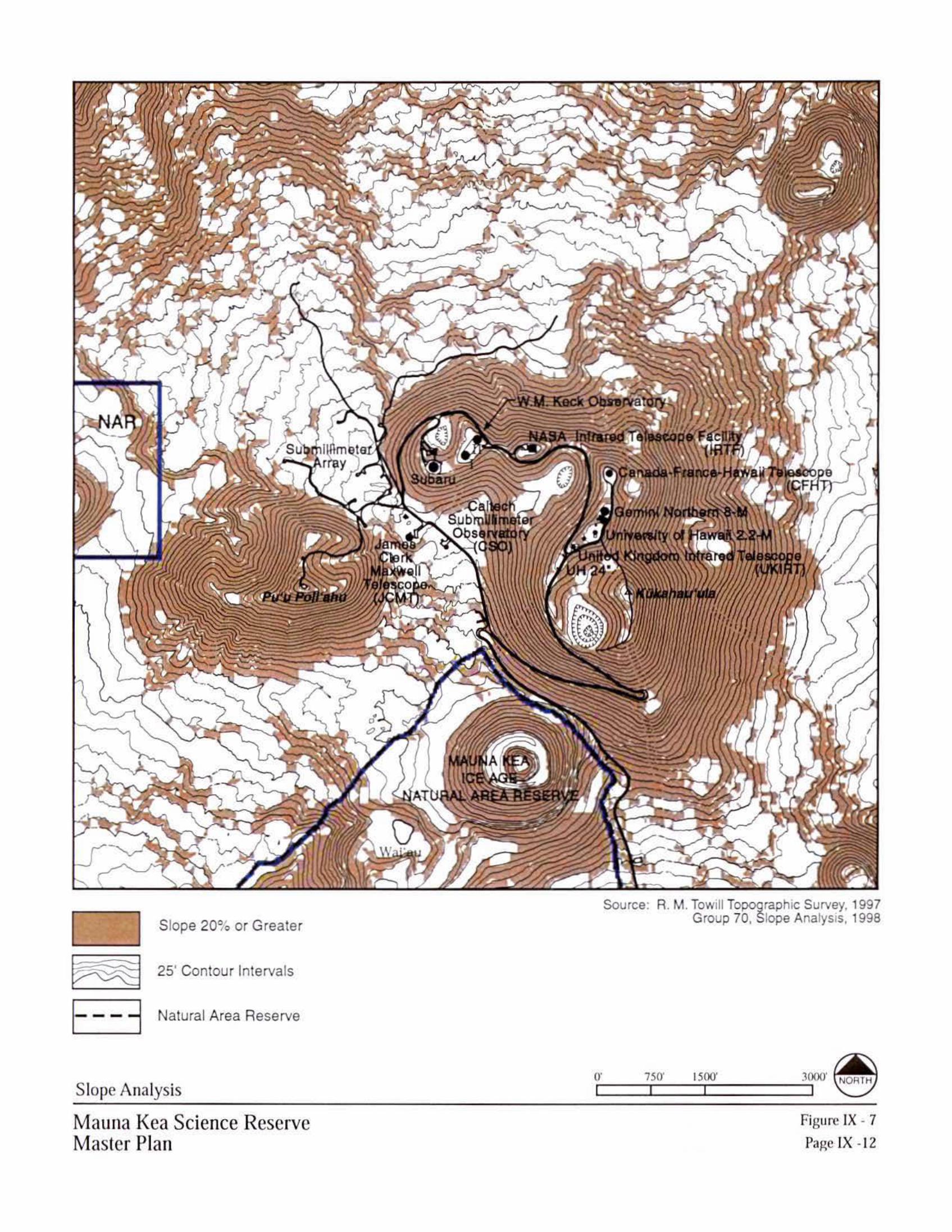
J"\... '
Slope 20% or Greater
25' Contour Intervals
- - - - Natural Area Reserve
Slope Analysis
Mauna l(ea Science Reserve Master Plan
Source: R. M. Towill Topographic Survey, 1997 Group 70, Slope Analysis, 1998
or·- __ 7~50_' __ 15~00_' ____ ~ 3000' ~
Figure IX - 7 Page IX -12

Natural AreaReserve
40' Contour Intervals
Potential Cystopteris fern habitat
Potential lichen habitat
Summit Flora Habitat
Mauna Kea Science ReserveMaster Plan
Figure IX - 8Page IX -13
0' 2000' 4000' 8000' NORTH
NAR
Source: Winona Char, 1999Note: Mosses are found throughout the summit area, primarily
on rock outcroppings with crevices and fissures.~ ~ ~

Mauna Kea Science Reserve Master PlanPhysical Planning Guide Page IX - 14
Fauna Habitat. Arthropod distribution on the upper slopes of Mauna Kea relatesdirectly to the surface geology. The Wëkiu bug (Nysius wëkiucola) is found primarily inthe undisturbed cinders of the large cinder cones at Mauna Kea’s summit, as shown inFigure IX-9. Other arthropod species such as the Lycosid wolf spider and Noctuid mothsare more widespread within the Science Reserve. Lower elevation areas on Mauna Kea,outside the Science Reserve, include faunal components relating to the mämane and naioforest ecosystem.
GIS mapping shows the extent of areas of Wëkiu bug concentration, including areas withdocumented presence of the bug and areas of suitable habitat. The Master Plan willminimize disturbance of the cinder cone habitat for the Wëkiu bug within the ScienceReserve. Expansion or redevelopment of existing sites on the summit ridge will havecontained localized effects to the cinder cone habitat in the immediate vicinity of theolder telescopes. As a result of the overall preservation measures, the habitat of theWëkiu bug in the Mauna Kea Science Reserve will be protected. A composite of naturalresources in the summit area is presented in Figure IX-10.
Archaeological Resources. Archaeological sites are found in the upper slopes of theScience Reserve, yet sites are virtually absent in the proximity of the summit puÿu.Shrines are clustered around the summit at approximately the 13,000 ft. elevation. Referto Section V for more detailed information about archaeological sites. The clustering ofsites appears around Lake Waiÿau and the adze quarry in the NAR, at site complexesadjacent to the summit access road, and large numbers of shrines on the north slope at theedge of the plateau around the 13,000 ft. elevation. A consistent pattern was found,suggesting that shrines were erected by Hawaiians travelling up the mountain as tributesto their deity. Based on the field research, archival studies and oral histories, there are noburial sites in the vicinity of the summit puÿu. The plan preserves the areas near thehigher concentrations of archaeological sites, restricting these areas from futuredevelopment and most activities. Figure IX-11 shows the extent of archaeological sites.
Cultural Properties/Landforms. Culturally-significant landforms and places at MaunaKea have been identified based on interviews and historical archival research. Refer toSection V for more detailed information about the cultural setting. A Cultural LandscapeMap is presented in Figure IX-3. The Master Plan avoids adverse effects to culturalproperties/landforms. The area of critical cultural importance encompasses the area ofPoliÿahu to Waiÿau to Kükahauÿula at the summit. The puÿu within the summit region arethe natural cultural landscape of Mauna Kea, with a visual linkage to the area of thesacred alpine lake at Waiÿau and the adze quarry at Keanakäkoÿi. Preservation of themajor puÿu of the summit in an unaltered state is essential to retaining their culturalsignificance, and will retain the integrity of vistas and site relationships. This approach isconsistent with the perspective taken by the Historic Preservation Plan DLNR (March2000), that Mauna Kea’s numerous shrines and culturally significant landforms along theupper slopes altogether constitute an historic district.

LocalizedWekiu Habitatfound throughoutthe region above13,000 feet
*
**
** *
*
12750
12700
12675
12725
12775
12725
12775
12750
12800
12825
12850
12875
12925
12900
1285
0
12925
12875
12950
12975
13000
12975
12950
12975
12950
1297
5
13000
12925
12900
12975
12950
13000
13025
13050
13075
13100
13125
13175
13225
13275
13325
13350
13275
13250
13300
1325
0
13300
1325013225
13275
13325
1332
513350
13350
1357
5
13375
13600
13450
1355
0
13400
13550
13500
13475
1337513425
1352513575
13575
13375
13400
13425
13475
13525
13575
13075
1305013025
13000
12975
12950
12900
1310
0
1322
5
1317
5
13200
1315
0
1312
5
13075
1292
5
1297
512
950
12825
1280
012
850
1290
0
12875
12875
13225
13250
13350
1330013275
13175
13200
13150
13125
13050
12950
13100
13075
12925
13025
13000
12975
12925
1290
0
13450
1355
0
13500
13400
12825
1272
512
70012
675
1265
0
1277
5
1275
0
1257
5
1262
5
12600
12725
1280
0
12775
12700
12650
12625
12600
12750
12675
12825
12800
12775
12750
1287512850
12725
1270
0
13325
12800
12775
12750
12975
12825
12875
12850
12900
12925
12950
13125
13000
13025
13050
13075
13100
13150
13175
13200
13225
13250
13275
13300
12600
1262
5
1265
0
1290
0
13450
1277
5
13350
1287
51290
0
1280
01282
51285
0
1297
5
1315
0
1317
5
1300
0
1302
5
1305
0
1307
5
1310
0
1312
5
1320
0
1292
51295
0
12925
12900
1295012975
13000
1272
5
12675
12700
12750
12750
12775
1280
0
1282
5
1285
0
12775
12875
1372
5
13675
13375
13425
135251355013575136001362513650
13450
13400
1347513500
1375
013700
1372
5
1375
0
13700
1370
0
13725
1370013675
13625
13600
13575
13550
13650
13150
13125
13075
13350
13300
1332513350
13150
13125
13100
13200
13325
13300
13275
13250
13225
13175
1320013225
13250
13275
1312513150
13175 13025
13050
13075
13100
13050
13075
13100
13050
13025
12975
12950
13000
12925
12900
12875
12950
13000
12975
1295012975
13025
13075
1297
512
9501292
5
1310
01305
01300
0
12825
12775
12800
12875
12850
12900
12875
12850
12825
12800
13425
1352513500
1347513450
13400
13375
13425
1337513400
12725
12800
12825
12775
12750
12850
12700
12675
1275
0
1282
51280
0
1277
512
875
1285
0
1272
5
1270
0
12675
Figure IX - 9
Page IX - 15
Potential Wëkiu Habitat
Source: Dr. Frank Howarth, Bishop Museum, 1999
Likely Habitat/Specimens Found
Likely Habitat
Likely Habitat/Presence Unknown
25' Contour Intervals
Natural Area Reserve
Specimens Found 1997-1998
Mauna Kea Science ReserveMaster Plan
0' 750' 1500' 3000' NORTH
United Kingdom Infrared Telescope(UKIRT)
JamesClerk
MaxwellTelescope
(JCMT)
NARSubmillimeter
Array
Pu’u Poli’ahu
CaltechSubmillimeterObservatory
(CSO)
Subaru
W.M. Keck Observatory
NASA Infrared Telescope Facility(IRTF)
Canada-France-Hawaii Telescope(CFHT)
Gemini Northern 8-M
University of Hawaii 2.2-M
MAUNA KEAICE AGE
NATURAL AREA RESERVE
III
Kükahauÿula
Wai‘au
UH 24"
CJ EITfil]
~ E3 CJ

LocalizedWekiu Habitatfound throughoutthe region above13,000 feet
12750
12700
12675
12725
12775
12725
12775
12750
12800
12825
12850
12875
12925
12900
1285
0
12925
12875
12950
12975
13000
12975
12950
12975
12950
1297
5
13000
12925
12900
12975
12950
13000
13025
13050
13075
13100
13125
13175
13225
13275
13325
13350
13275
13250
13300
1325
0
13300
1325013225
13275
13325
1332
513350
13350
1357
5
13375
13600
13450
1355
0
13400
13550
13500
13475
1337513425
1352513575
13575
13375
13400
13425
13475
13525
13575
13075
1305013025
13000
12975
12950
12900
1310
0
1322
5
1317
5
13200
1315
0
1312
5
13075
1292
5
1297
512
950
12825
1280
012
850
1290
0
12875
12875
13225
13250
13350
1330013275
13175
13200
13150
13125
13050
12950
13100
13075
12925
13025
13000
12975
12925
1290
0
13450
1355
0
13500
13400
12825
1272
512
70012
675
1265
0
1277
5
1275
0
1257
5
1262
5
12600
12725
1280
0
12775
12700
12650
12625
12600
12750
12675
12825
12800
12775
12750
1287512850
12725
1270
0
13325
12800
12775
12750
12975
12825
12875
12850
12900
12925
12950
13125
13000
13025
13050
13075
13100
13150
13175
13200
13225
13250
13275
13300
12600
1262
5
1265
0
1290
0
13450
1277
5
13350
1287
51290
0
1280
01282
51285
0
1297
5
1315
0
1317
5
1300
0
1302
5
1305
0
1307
5
1310
0
1312
5
1320
0
1292
51295
0
12925
12900
1295012975
13000
1272
5
12675
12700
12750
12750
12775
1280
0
1282
5
1285
0
12775
12875
1372
5
13675
13375
13425
135251355013575136001362513650
13450
13400
1347513500
1375
013700
1372
5
1375
0
13700
1370
0
13725
1370013675
13625
13600
13575
13550
13650
13150
13125
13075
13350
13300
1332513350
13150
13125
13100
13200
13325
13300
13275
13250
13225
13175
1320013225
13250
13275
1312513150
13175 13025
13050
13075
13100
13050
13075
13100
13050
13025
12975
12950
13000
12925
12900
12875
12950
13000
12975
1295012975
13025
13075
1297
512
9501292
5
1310
01305
01300
0
12825
12775
12800
12875
12850
12900
12875
12850
12825
12800
13425
1352513500
1347513450
13400
13375
13425
1337513400
12725
12800
12825
12775
12750
12850
12700
12675
1275
0
1282
51280
0
1277
512
875
1285
0
1272
5
1270
0
12675
Mauna Kea Science ReserveMaster Plan
Figure IX - 10
Page IX - 16
Natural Resource Composite
Likely Habitat/Specimens Found
Likely Habitat
Likely Habitat/Presence Unknown
Fern Habitat
Lichen Habitat
Slope 20% or Greater
25' Contour Intervals
Natural Area Reserve
Wëkiu Habitat Flora Habitat
0' 750' 1500' 3000' NORTH
JamesClerk
MaxwellTelescope
(JCMT)
NARSubmillimeter
Array
Pu’u Poli’ahu
CaltechSubmillimeterObservatory
(CSO)
Subaru
W.M. Keck Observatory
NASA Infrared Telescope Facility(IRTF)
Canada-France-Hawaii Telescope(CFHT)
Gemini Northern 8-M
University of Hawaii 2.2-M
MAUNA KEAICE AGE
NATURAL AREA RESERVE
Wai‘au
III
Kükahauÿula
United Kingdom Infrared Telescope(UKIRT)UH 24"
CJ [filTI]
CJ ~ E3

12750
12700
12675
12725
12775
12725
12775
12750
12800
12825
12850
12875
12925
12900
1285
0
12925
12875
12950
12975
13000
12975
12950
12975
12950
1297
5
13000
12925
12900
12975
12950
13000
13025
13050
13075
13100
13125
13175
13225
13275
13325
13350
13275
13250
13300
1325
0
13300
1325013225
13275
13325
1332
513350
13350
1357
5
13375
13600
13450
1355
0
13400
13550
13500
13475
1337513425
1352513575
13575
13375
13400
13425
13475
13525
13575
13075
1305013025
13000
12975
12950
12900
1310
0
1322
5
1317
5
13200
1315
0
1312
5
13075
1292
5
1297
512
950
12825
1280
012
850
1290
0
12875
12875
13225
13250
13350
1330013275
13175
13200
13150
13125
13050
12950
13100
13075
12925
13025
13000
12975
12925
1290
0
13450
1355
0
13500
13400
12825
1272
512
70012
675
1265
0
1277
5
1275
0
1257
5
1262
5
12600
12725
1280
0
12775
12700
12650
12625
12600
12750
12675
12825
12800
12775
12750
1287512850
12725
1270
0
13325
12800
12775
12750
12975
12825
12875
12850
12900
12925
12950
13125
13000
13025
13050
13075
13100
13150
13175
13200
13225
13250
13275
13300
12600
1262
5
1265
0
1290
0
13450
1277
5
13350
1287
51290
0
1280
01282
51285
0
1297
5
1315
0
1317
5
1300
0
1302
5
1305
0
1307
5
1310
0
1312
5
1320
0
1292
51295
0
12925
12900
1295012975
13000
1272
5
12675
12700
12750
12750
12775
1280
0
1282
5
1285
0
12775
12875
1372
5
13675
13375
13425
135251355013575136001362513650
13450
13400
1347513500
1375
013700
1372
5
1375
0
13700
1370
0
13725
1370013675
13625
13600
13575
13550
13650
13150
13125
13075
13350
13300
1332513350
13150
13125
13100
13200
13325
13300
13275
13250
13225
13175
1320013225
13250
13275
1312513150
13175 13025
13050
13075
13100
13050
13075
13100
13050
13025
12975
12950
13000
12925
12900
12875
12950
13000
12975
1295012975
13025
13075
1297
512
9501292
5
1310
01305
01300
0
12825
12775
12800
12875
12850
12900
12875
12850
12825
12800
13425
1352513500
1347513450
13400
13375
13425
1337513400
12725
12800
12825
12775
12750
12850
12700
12675
1275
0
1282
51280
0
1277
512
875
1285
0
1272
5
1270
0
12675
16200
16202
18682
2119718683
16203
16175 16176
16178
212011618016179
2120216184
16169
16168
21205
16186
16187
16188
16192
21
16201
1619816196
16197
16163
16177
1617421198
16173
21199
16171
16170
16172
21200
16185
16166
16167
16164
16165
16181
16182
21203
16190
21408
21409
10
21411
21407
21415
21429
21417
2141821422
21432
16189
21430
21406
21209
16199
Mauna Kea Science ReserveMaster Plan
Figure IX - 11
Page IX - 17
25’ Contour Intervals
Natural Area Reserve
Historic Trails
Shrines
Marker
Unknown
Workshop
Source: Hawaii Department of Landand Natural Resources
Historic Preservation Division, Feb. 1999
Archaeology Sites MapNORTH0' 750' 1500' 3000'
UH 24"United Kingdom Infrared Telescope
(UKIRT)
JamesClerk
MaxwellTelescope
(JCMT)
NARSubmillimeter
Array
Pu’u Poli’ahu
CaltechSubmillimeterObservatory
(CSO)
Subaru
W.M. Keck Observatory
NASA Infrared Telescope Facility(IRTF)
Canada-France-Hawaii Telescope(CFHT)
Gemini Northern 8-M
University of Hawaii 2.2-M
Kükahauÿula
MAUNA KEAICE AGE
NATURAL AREA RESERVE
III
Wai‘au
0
v~~ ~~
~ E3 EJ .
. -~ .~~(!
~ /,-/ ,.., .., ·

Mauna Kea Science Reserve Master PlanPhysical Planning Guide Page IX - 18
Summary of the Natural and Cultural Resources Physical Planning Guide. The planprovides a clear future direction toward preservation of natural and cultural resources, bydirecting proposed new development to locations within the summit region where theresource values would not be diminished. A Natural and Cultural Resources Compositemap is presented in Figure IX-12. Since these resources are physically adjacent, they areplanned and managed together in a living, evolving and sustainable approach.Traditional access to the resources for cultural practitioners is unimpeded, as long as lawsare not violated. Natural resources will be preserved consistent with a growing interest inthe restoration of the overall mountain ecosystem. The relationship to existing plans andlaws regarding natural and cultural resources is addressed in the environmental review(EIS) process.
EDUCATION AND RESEARCH COMPONENTS
Mauna Kea has long enjoyed a revered place in native Hawaiian culture, in the lives ofthose who live on its slopes and all who come in contact with this, one of the world'stallest mountains. Study and research of the cultural and natural features of Mauna Keaare integral to contemporary use of Mauna Kea. Mauna Kea is also the world's premierastronomical research location, and astronomy on Mauna Kea is an essential element ofHawaiÿi’s economy and high technology future. The evolution of astronomy technology,and world-wide interest in astronomy research at this location, presents a current need toupgrade and expand telescope facilities. However, since the time the first telescopeswere proposed on Mauna Kea, there have been differing viewpoints about astronomydevelopment, as discussed in the previous section. There is a concern that astronomydevelopment has been distributed across the summit in an unattractive fashion, and thatthis development might eventually overtake the mountain. There also are concerns aboutthe potential impacts of development to natural resources, such as the Wëkiu bug habitat,archaeological sites and Hawaiian cultural resources.
The education and research component is the second integration of the physical planningguide, which joins the projected education and research uses with the natural and culturalresource component. The natural and cultural resources map identifies the preservationareas where resource values are highest, and development activity is guided elsewhere.
Overall objectives for education and research:
1. Expand knowledge of the Science Reserve as an educational resource for the benefitof the community, students, researchers, and visitors, through the planning process.

LocalizedWëkiu Habitatfound throughoutthe region above13,000 feet
*
**
** *
12750
12700
12675
12725
12775
12725
12775
12750
12800
12825
12850
12875
12925
12900
1285
0
12925
12875
12950
12975
13000
12975
12950
12975
12950
1297
5
13000
12925
12900
12975
12950
13000
13025
13050
13075
13100
13125
13175
13225
13275
13325
13350
13275
13250
13300
1325
0
13300
1325013225
13275
13325
1332
513350
13350
1357
5
13375
13600
13450
1355
0
13400
13550
13500
13475
1337513425
1352513575
13575
13375
13400
13425
13475
13525
13575
13075
1305013025
13000
12975
12950
12900
1310
0
1322
5
1317
5
13200
1315
0
1312
5
13075
1292
5
1297
512
950
12825
1280
012
850
1290
0
12875
12875
13225
13250
13350
1330013275
13175
13200
13150
13125
13050
12950
13100
13075
12925
13025
13000
12975
12925
1290
0
13450
1355
0
13500
13400
12825
1272
512
70012
675
1265
0
1277
5
1275
0
1257
5
1262
5
12600
12725
1280
0
12775
12700
12650
12625
12600
12750
12675
12825
12800
12775
12750
1287512850
12725
1270
0
13325
12800
12775
12750
12975
12825
12875
12850
12900
12925
12950
13125
13000
13025
13050
13075
13100
13150
13175
13200
13225
13250
13275
13300
12600
1262
5
1265
0
1290
0
13450
1277
5
13350
1287
51290
0
1280
01282
51285
0
1297
5
1315
0
1317
5
1300
0
1302
5
1305
0
1307
5
1310
0
1312
5
1320
0
1292
51295
0
12925
12900
1295012975
13000
1272
5
12675
12700
12750
12750
12775
1280
0
1282
5
1285
0
12775
12875
1372
5
13675
13375
13425
135251355013575136001362513650
13450
13400
1347513500
1375
013700
1372
5
1375
0
13700
1370
0
13725
1370013675
13625
13600
13575
13550
13650
13150
13125
13075
13350
13300
1332513350
13150
13125
13100
13200
13325
13300
13275
13250
13225
13175
1320013225
13250
13275
1312513150
13175 13025
13050
13075
13100
13050
13075
13100
13050
13025
12975
12950
13000
12925
12900
12875
12950
13000
12975
1295012975
13025
13075
1297
512
9501292
5
1310
01305
01300
0
12825
12775
12800
12875
12850
12900
12875
12850
12825
12800
13425
1352513500
1347513450
13400
13375
13425
1337513400
12725
12800
12825
12775
12750
12850
12700
12675
1275
0
1282
51280
0
1277
512
875
1285
0
1272
5
1270
0
12675
Figure IX - 12
Page IX - 19
Natural & Cultural Resources Composite
Likely Habitat/Specimens Found
Likely Habitat
Likely Habitat/Presence Unknown
Specimens Found 1997-1998
25’ Contour Intervals
Natural Area Reserve
Mauna Kea Science ReserveMaster Plan
Shrines
Marker
Unknown
Workshop
Slope 20% or Greater
ArchaeologyWëkiu
0' 750' 1500' 3000' NORTH
United Kingdom Infrared Telescope(UKIRT)
JamesClerk
MaxwellTelescope
(JCMT)
NARSubmillimeter
Array
Pu’u Poli’ahu
CaltechSubmillimeterObservatory
(CSO)
Subaru
W.M. Keck Observatory
NASA Infrared Telescope Facility(IRTF)
Canada-France-Hawaii Telescope(CFHT)
Gemini Northern 8-M
University of Hawaii 2.2-M
MAUNA KEAICE AGE
NATURAL AREA RESERVE
III
Kükahauÿula
Wai‘au
UH 24"
Area of Least Physical Impact&
Concentration of Shrines
*
1 I 1::::::::::::::::::::::1
I I
•
■
~ I- - - -l I I

Mauna Kea Science Reserve Master PlanPhysical Planning Guide Page IX - 20
2. Protect natural and cultural resources and insure managed access to the ScienceReserve for education and research use.
3. Protect and enhance astronomy research at Mauna Kea as it is the premierobservatory site in the Northern Hemisphere.
4. Define areas, criteria and support facilities for education and research as applicable,to allow for sustainable, integrated planning and management.
Astronomy Precinct
An “Astronomy Precinct” is defined where development will be consolidated to maintaina close grouping of astronomy facilities, roads and support infrastructure. This approachminimizes the potential impact to the natural and cultural resources of the summit region.The criteria to be followed for new facilities proposed in the Astronomy Precinct include:
• Emphasize the recycling of existing sites so as not to disturb existing habitat areas,archaeology and landforms;
• Limit visual impact and scattering of facilities by clustering within the existingdevelopment area, recognizing that facilities have already been built in this area andpresently have a visual impact;
• Utilize the natural forms in the summit area to shield views of built facilities, fromboth off-mountain and atop this mountain;
• Implement design measures to allow facilities to blend in better with the naturallandscape, to minimize the sense of disruption to the landscape; and
• Minimize infrastructure development by locating near the existing roadway andutility network.
As shown in Figure IX-13, the Astronomy Precinct is defined by the limits of the criticalresource areas identified within the natural and cultural resources component of theMaster Plan, as well as by considering the siting needs of future astronomy facilities.The Astronomy Precinct will be approximately 525 acres, or less than five percent(4.65%) of the existing Science Reserve. The boundaries of the Precinct have beenestablished based on the following resources:
• Northern boundary: The boundary to the North avoids clusters of archaeological sites(shrines) found at the 13,000 ft. elevation, providing a minimum 200 ft. setback. Thissetback distance is 10 times the setback distance required by the Hawaiÿi IslandBurial Council for development near existing burials.
• Eastern boundary: The Eastern slope of the summit is a broad natural area, with nodevelopment at present and which is highly visible from the Hilo area. This willensure no development on this slope.
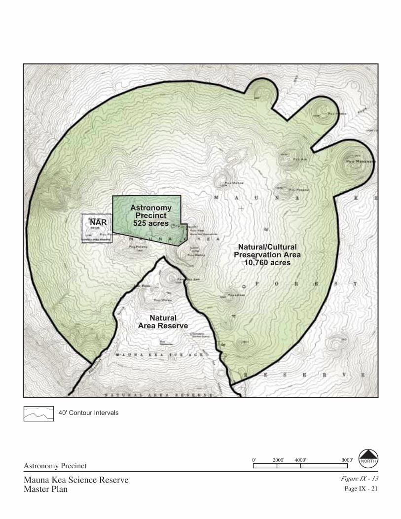
Mauna Kea Science ReserveMaster Plan
Figure IX - 13
Page IX - 21
Astronomy Precinct0' 2000' 4000' 8000' NORTH
NaturalArea Reserve
NAR
40' Contour Intervals
Natural/CulturalPreservation Area
10,760 acres
AstronomyPrecinct
525 acres

Mauna Kea Science Reserve Master PlanPhysical Planning Guide Page IX - 22
• Southern boundary: The culturally significant places of Poliÿahu and Kükahauÿula,and the intervening area between Poliÿahu and Waiÿau, set the Precinct limits to thesouth. This also respects the Wëkiu bug habitat associated with the summit cindercone. The precinct boundary also retains an open view from Kükahauÿula toward thewestern slope of Mauna Kea, which some have identified as a potentially importantresource of cultural and religious significance.
• Western boundary: The NAR and Pu’u Pöhaku and steep slopes set the western limit.
Included within the Astronomy Precinct are three shrines out of the 93 archaeologicalfeatures which have been identified in the Science Reserve. The Precinct includesrelatively flat areas, and the potential development locations within the Precinct arelargely shielded from Waiÿau and the existing roads. In addition, the implementation ofdesign guidelines outlined at the end of this chapter will minimize the visibility ofproposed new astronomy facilities within the Astronomy Precinct.
Astronomy Precinct Detailed Plan - Siting Criteria. Specific siting criteria have beenset for locating new facilities within the Astronomy Precinct. These criteria include:
1. Minimal impact on existing facilities. Existing astronomy facilities require a clear lineof sight to approximately 12 degrees above the horizon in a full circle. The locationof proposed new facilities cannot obscure the observation function of the existingtelescopes on the mountain. Proposed new facilities must be spaced accordinglywithin the Astronomy Precinct.
2. Minimum impact of Wëkiu bug habitat. The major puÿu in the area of the summit allpossess confirmed or likely habitat for Wëkiu bug where the cinder cone surfacegeology is present. Only the existing disturbed locations on puÿu or areas outside ofthe Wëkiu bug habitat will be considered as potential siting areas.
3. Avoidance of archaeological sites. There are three existing archaeological shrineswithin the Astronomy Precinct, and these sites must be avoided in future facilitysiting. In addition, any new facilities will be set back at least 200 feet from theclustered group of shrines found outside the Precinct boundary on the northern slope.This setback distance is 10 times the setback distance required by the Hawaiÿi IslandBurial Council for development near existing burials.
4. Suitability for Observations. Potential sites for new observatories within theAstronomy Precinct must meet specific standards for conducting astronomicalobservations, including acceptable obscuration and wind flow conditions.
5. Minimum visual impact from significant cultural areas. Views from the puÿu andarchaeological sites will be respected in the siting of future facilities. The location ofnew facilities will avoid interference with the visual connections between the majorpuÿu and the shrine complexes.

Mauna Kea Science Reserve Master PlanPhysical Planning Guide Page IX - 23
6. Avoid or minimize views from Waimea, Honokaÿa and Hilo. Sites for proposed newfacilities will maximize the use of the existing topography to shield views from thedownslope communities. Prominent sites along the ridges or puÿu will not be selectedfor new development of astronomy or other research and education facilities.
7. Close to roads and existing infrastructure. Sites for proposed new development willbe selected close to the existing roadways to minimize the amount of disturbance tothe natural terrain. Utilities and communications service to new sites will beextended along the existing roadway routes to minimize disturbance.
Astronomy Precinct – Telescope Siting Areas. The 1983 plan included seven areas inthe Science Reserve that were designated as Analysis Areas, as shown in Figure VIII-3.Of these seven areas, four areas (A-D) were designated as Telescope Siting Areas. Therewas an ample allocation of space in each of the 1983 Siting Areas, to allow for flexibilityin the siting of telescopes that had yet to be designed and built on the summit.
The total area allocated in the 1983 plan for telescope siting in the four areas totaledapproximately 160 acres. All of the existing observatories and anticipated new facilitiesin the 1983 Plan were to be sited within these four areas, as shown in Figure IX-14.Only the Siting Areas A, B and C have been utilized for observatory development up tothis point.
The update of the Master Plan enables the refinement of the Telescope Siting Areaswithin the Astronomy Precinct, to include all existing observatories, proposedredeveloped facilities and new facility sites. Proposed Telescope Siting Areas (2000-2020) are shown in Figure IX-15, consistent with criteria described above.
Siting Areas A, B and C are already developed with observatories. All the instrumentsproposed in the previous plan are constructed, and the limits of these observatory sitesdefine Areas A, B and C. There is little area available for new telescope development inthese three siting areas, however, redevelopment of existing facilities would be possible.
Within the Astronomy Precinct, new telescope siting areas were identified consistent withthe siting criteria described earlier. The areas which are anticipated to provide suitableobservation conditions with minimum impact on existing facilities, wekiu bug habitat,archaeological sites and minimal visual were selected as the new telescope areas D, E andF, as delineated in Figure IX-15. Each expansion area is linked to the existing unpavedroads, which minimizes disturbance to the natural terrain. In the new plan, Areas D andE are expansion areas that are located in the vicinity of Area D from the 1983 plan;however, the new Areas D & E will avoid sensitive shrines that were previously locatedin the siting area. Area F is located in the vicinity of an Analysis Area V from theprevious plan (Figure VIII-3).

Mauna Kea Science ReserveMaster Plan
Figure IX - 14
Page IX - 24
Telescope Siting Areas (1983)
E NDITTS

Telescope Siting Areas (2000-2020)
Mauna Kea Science ReserveMaster Plan
Figure IX - 15Page IX - 25
0' 750' 1500' 3000' NORTH
40' Contour Intervals
Telescope Siting AreasA-F

Mauna Kea Science Reserve Master PlanPhysical Planning Guide Page IX - 26
Compared to the 1983 Telescope Siting Areas, the current plan reduces Areas A and B,reconfigures Areas C and D, and adds Areas E and F. The current Master Plan reducesthe total area allocated for Telescope Siting Areas to approximately 150 acres, ascompared to approximately 160 acres in the 1983 plan.
Telescope Siting Areas(1983 Complex Development Plan)
Telescope Siting Areas(Updated Master Plan 2000-2020)
AreaDesignation
ApproximateArea (ac.)
AreaDesignation
ApproximateArea (ac.)
A 18 A 10B 34 B 22C 35 C 43D 75 D 16
E 36F 23
Total 162 Total 150
Astronomy Precinct - Definition of a Telescope. The 1998 report by the StateLegislative Auditor recommends departing from the simplistic counting of “telescopes”at the Mauna Kea Science Reserve. To help clarify the issue of counting telescopes, it isappropriate to examine the definition of a telescope. Webster defines “telescope” asfollows: An instrument for collecting and examining electromagnetic radiation. This isconsistent with the working definition for telescopes within astronomy. A telescope musthave the capacity to collect as well as examine visible light and/or invisible radiation –i.e., it must be capable of making astronomical observations.
By this definition, Keck, Gemini, Subaru, Canada-France-Hawaii, both U.H. facilities,UKIRT, JCMT (Maxwell), VLBA, and Caltech are telescopes. The Submillimeter Array(SMA), when taken as a whole, is a telescope, but not each antenna. Each antennacollects radiowaves, but is not capable of providing astronomy observations. If a controlbuilding were attached to each antenna, then these antennas would be consideredtelescopes. The control buildings would, of course, be larger than the antenna. In thesame way, the proposed 4-6 Keck outriggers are collectors which are part of aninterferometer and not individual telescopes. When connected to the control buildingwithin the existing Keck, they would form one interferometric telescope.

Mauna Kea Science Reserve Master PlanPhysical Planning Guide Page IX - 27
An analogy for an array telescope is a stereo system. Each speaker is not a stereo systemin itself but all the components make up one system. Each part is considered acomponent with a specific name and purpose. The use of the term “stereo” to refer to aspeaker, receiver, tape deck, etc. is inappropriate. In the same way, the use of the term“telescope” for components is inappropriate.
The approach taken by the Master Plan is to describe the actual components of proposedastronomy development. This approach provides for full disclosure to the extent possiblewhen viewing the future of astronomy facilities atop Mauna Kea, and is consistent withthe Auditor’s recommendation to get away from the simplistic counting of “telescopes”.
Astronomy Precinct - Anticipated Program for Astronomy Development. The projectedexpansion of astronomy research facilities at Mauna Kea is specified in the Institute forAstronomy’s Research Development Program (2000-2020), which is included inAppendix A. The anticipated program for astronomy development envisions fivedifferent categories of facility development projects (Types I-V), as listed below.
Type I. Redevelopment of Existing Observatory Sites on the Summit Ridge:Redevelopment or “recycling” of up to five existing telescopes, including NASA/IRTF,CFHT, UH 2.2 m, UKIRT, and UH 0.6 m. It is anticipated that up to three or fourfacilities may be redeveloped over the next 20 years.
Type II. Expansion of Existing Observatories:Expansion of the Keck Observatory with the addition of four to six 1.8-m. outriggertelescopes. Four are being proposed to start development in 2001. The SubmillimeterArray may add up to 12 new antennas and 24 new pads over the next 20 years.
Type III. New Conventional Optical/IR TelescopeA new conventional telescope comparable to the Keck or Gemini Observatories at acurrently undeveloped site. An instructional telescope for UH-Hilo is also projected.
Type IV. Next Generation Large Telescope (NGLT)A single optical/IR telescope of 25 m. aperture or greater. This is currently only beingdiscussed in the astronomy community and there is a 50 percent possibility that thisfacility may be developed in the next 20 years.
Type V. Optical/IR Interferometer Array SiteA general area is proposed for this observatory. No facilities are included in this Plan.Facilities must undergo the major Master Plan amendment process for approval.
Given the prescribed criteria for site selection, and UH’s anticipated program forastronomy development in the next 20 years, specific sites or areas within the AstronomyPrecinct have been identified. A summary of all proposed research facilitiesdevelopment in the Astronomy Precinct is presented in Figure IX-16. An expandeddiscussion of each of the proposed facility type and locations is presented below.
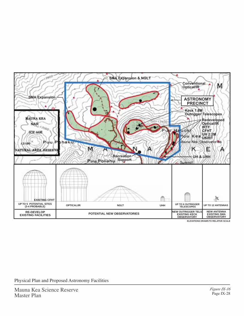
Figure IX-16Page IX-28
Mauna Kea Science ReserveMaster Plan
Physical Plan and Proposed Astronomy Facilities
RecreationSupport
ConventionalOptical/IR
RedevelopedOptical/IRIRTFCFHTUH 2.2MUKIRT
Keck 1.8MOutrigger Telescopes
UH & UHH
OPTICAL/IR NGLT UHHUP TO 5 POTENTIAL SITES
(3-4 PROBABLE)UP TO 6 OUTRIGGER
TELESCOPES
EXISTING CFHT
RE-DEVELOPEXISTING FACILITIES POTENTIAL NEW OBSERVATORIES
NEW OUTRIGGER TELSEXISTING KECKOBSERVATORY
NEW ANTENNAEXISTING SMAOBSERVATORY
NAR
ELEVATIONS DRAWN TO RELATIVE SCALE
UP TO 12 ANTENNAS
ASTRONOMYPRECINCT
SMA Expansion & NGLT
SMA Expansion

Mauna Kea Science Reserve Master PlanPhysical Planning Guide Page IX - 29
Type I. Redevelopment of Existing Observatory Sites on the Summit Ridge.
The most likely type of astronomy development at Mauna Kea would be the replacementor upgrading of facilities at existing sites, as a first preference, or the development of newsites as a second preference. It is expected that the proposed new or upgradedconventional optical/IR telescopes will come in a range of sizes, from 2 to 15 m. mirrorsizes. The 10 m. mirrors of the existing Keck, Gemini and Subaru telescopes representthe current state-of-the-art instrument.
The first priority for siting these facilities will be the recycling of existing facilities thathave aging technology, such as the IRTF, CFHT, UKIRT, UH 2.2 m. and UH 0.6 m.These five telescope sites have already been disturbed by development activities, and thefacilities are part of the existing visual setting. The IRTF, CFHT, UKIRT, UH 2.2 m. andUH 0.6 m. are all over 20 years old, and the current technology for conventionaltelescopes is far superior. The present sites on the summit ridge are attractive for locatingnew or upgraded facilities because of known high quality locations and existinginfrastructure. Most of the existing observatory organizations may be unable to operateboth a new facility and the existing one, so they will prefer to recycle their existing site.
We expect to see a trend toward specialization for these conventional-sizeoptical/infrared telescopes. For example, one facility may decide to concentrate on wide-field imaging, while another focuses on using adaptive optics to achieve the highestpossible angular resolution over a small field. Specialization will allow the telescopefacility to achieve the ultimate in performance within the chosen area of research, whileat the same time simplifying the operation and thereby reducing costs. Specializationwill provide a strong incentive for joint operating arrangements and shared use among theobservatory organizations.
During the 20-year period of this Master Plan, it is expected that there may be proposalsto upgrade or replace each of these five telescopes on the summit ridge with conventionaloptical/IR telescopes. Over the next 20 years, it is estimated that only three or four ridgefacility upgrades will actually be constructed over this time period, including thereplacement of the UH 0.6 m. telescope with a facility in the 2 to 3 meter mirror sizerange.
In addition to the replaced/upgraded conventional optical/IR telescopes on the ridge, UH-Hilo plans to construct an instructional telescope (1 m. mirror) adjacent to the existingUH 0.6 m. telescope on the existing site of a utility/storage building. Use of the facility isanticipated to be primarily instructional, with research uses only for programs withsubstantial academic or other instructional content, or when the telescope is not neededfor such programs.
Figure IX-16 identifies the sites with the greatest potential for upgrades, expansion orredevelopment. A perspective view is shown in Figure IX-17.
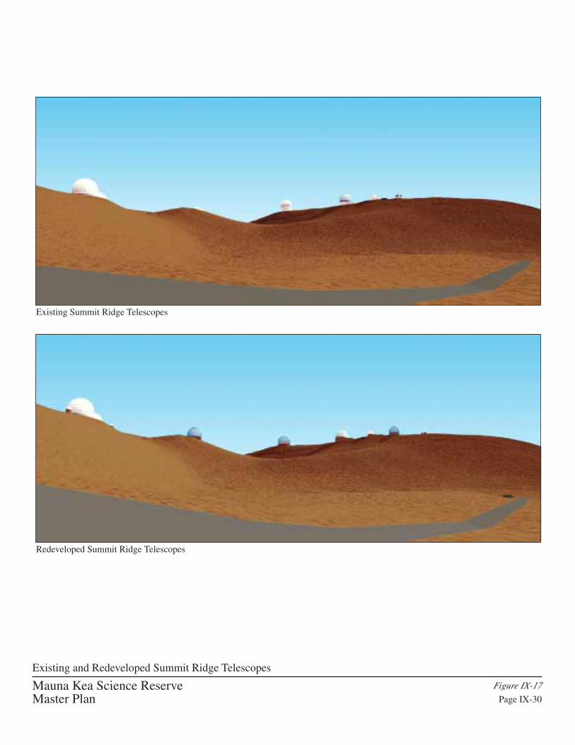
Mauna Kea Science ReserveMaster Plan
Figure IX-17
Page IX-30
Existing and Redeveloped Summit Ridge Telescopes
Existing Summit Ridge Telescopes
Redeveloped Summit Ridge Telescopes

Mauna Kea Science Reserve Master PlanPhysical Planning Guide Page IX - 31
Future telescope redevelopment on the summit ridge will limit these facilities to amaximum height and diameter of approximately 130 feet, to limit the visual impact alongthe ridge. This standard is derived from the approximate dimensions of the existingGemini and Keck class of telescope. For more specific standards for these facilities, referto the design guidelines at the end of this chapter.
A three-dimensional perspective of the summit ridge under existing conditions and withrecycled/upgraded telescopes, as viewed from the access roadway in “Millimeter Valley”near the James Clerk Maxwell Telescope, is included in Figure IX-17. The view fromoff-mountain locations of the summit ridge with the redeveloped conventional Optical/IRtelescopes is shown in Figures IX-22, 23 and 24.
Type II. Expansion of Existing Observatories.
Expansion of the W. M. Keck Observatory. The addition of four to six 1.8-m. outriggertelescopes is planned to create a powerful infrared interferometer on the existing Kecksite. The primary purpose is to study planetary systems around nearby stars. Funding isto be provided by NASA, with four of six outriggers already funded. The outriggertelescopes will test the feasibility and capability of IR interferometers, as a precursor tospace-based interferometry missions including the Terrestrial Planet Finder. On a tightschedule because of its link to planned space missions, NASA would like to startconstruction in 2001. The Keck Outrigger Telescopes project is the only new projectproposed for Mauna Kea at present.
The location of the Keck outrigger telescopes on the existing Keck site is shown inFigure IX-16. This site is already disturbed from the development of the two Keckfacilities, and the outrigger telescopes will not extend beyond the existing site. From anatural and cultural resource perspective, the impact of the project is negligible. There isno better location for this facility since it requires a combination with the existing Keckfacilities. The proposed use of the existing site allows for the project to be built withoutdamaging existing Wëkiu bug habitat found in the surrounding area.
A three-dimensional view of the outrigger telescopes is presented in Figure IX-18. Thenew outrigger telescopes will be much smaller in scale in comparison to the existingKeck telescopes, only about 35 ft. in height. The visibility of the outriggers telescopesfrom areas at the summit is very limited, and off-mountain views will not be affected. Asimulated view of the summit from off-mountain locations at Hilo, Honokaÿa andWaimea, including the completed Keck outrigger telescopes, is shown in Figures IX-22,23 and 24.

Figure IX-18Page IX-32
W.M. Keck Observatory with Proposed Outrigger Telescopes
Mauna Kea Science ReserveMaster Plan

Mauna Kea Science Reserve Master PlanPhysical Planning Guide Page IX - 33
Expansion of the Submillimeter Array (SMA). The existing SMA is anticipated to beoperating in 2001. Within the next 20 years, it is likely there will be a need to expand theexisting SMA, to include up to 12 new antennas and 24 additional pads. Some of theseantennas may differ somewhat in size and structure from the current SMA antennas andoperate independently of the others. This expansion will increase the sensitivity andangular resolution of the SMA and will allow for multiple studies to take placeconcurrently within a densified and elongated array.
Location issues involved with the submillimeter involve technical siting issues (slope andobscuration) and natural/cultural resource constraints. One of the potential arrayconfigurations, considered prior to this Master Plan, included the area to the south of theexisting array, extending between Poliÿahu and Waiÿau. Use of this area, however, wouldnot fit with the natural and cultural resource component of the Plan. The inter-relationship between Poliÿahu, Waiÿau and Kükahauÿula (summit) is recognized asculturally significant, and the placement of antennas in the valley between these featureswould detract from this resource.
The expansion area will extend the baseline for this antenna complex approximately 0.5km to the north and west of the existing array. Figure IX-16 shows the potentialexpansion area for the submillimeter array. A three-dimensional perspective view of theexpanded submillimeter array is included in Figure IX-19.
The submillimeter array expansion will be concentrated in the area to the north of PuÿuPoliÿahu, and will not be visible from Hilo and Honokaÿa. It will probably not be visiblefrom Waimea, as shown in Figure IX-23.
Due to the relatively small size of the SMA antennas (25 ft. in height) they are virtuallyinvisible from a distant perspective. To further diminish the visual impact of the SMAfacilities, the concrete pads for the new antennas should be colored in a brown tone tomatch the surrounding lava/ash landscape. To the extent possible the SMA facilities willbe sited to utilize the existing road and pathways.

Figure IX-19Page IX-34
Proposed Submillimeter Array Expansion
Mauna Kea Science ReserveMaster Plan

Mauna Kea Science Reserve Master PlanPhysical Planning Guide Page IX - 35
Type III. New Conventional Optical/IR Telescope
The second priority for siting proposed conventional optical/IR telescopes will be at anew site within the Astronomy Precinct, and only if a suitable summit ridge site cannotbe utilized for redevelopment. In the event there is no existing site available, there is anarea to the north of the summit ridge that could potentially support a new conventionaloptical/IR telescope. Infrastructure expansion issues are a potential concern for any newfacility that is not accessible from existing roadways. The north shield has not beenthoroughly tested for seeing conditions, and a future site for facility development in thisarea would be contingent on positive findings from seeing analysis.
The proposed site for a new conventional optical/IR telescope is shown in Figure IX-16and a perspective view is shown in Figure IX-20. The selection of this new site withinthe Astronomy Precinct generally satisfies the specific siting criteria, including:
1. Minimal impact on existing facilities. A facility proposed at a location to the north ofthe summit ridge will not cause obscuration for any existing telescopes on themountain.
2. Minimum impact of Wëkiu bug habitat. The area to the north slope is outside of theknown Wëkiu bug habitat with no puÿu or cinder cone surface geology.
3. Avoidance of archaeological sites. There are no existing archaeological features inthe north slope portion of the Astronomy Precinct. The new facility will be set backat least 200 feet from the clustered group of shrines found outside the Precinctboundary further to the north (toward Honokaÿa and Waimea). This setback distanceis 10 times the minimum setback distance required by the Hawaiÿi Island BurialCouncil for development near existing burials.
4. Minimum visual impact from significant cultural areas. Telescope sites on the northslope would be visible from archaeological sites when looking toward the summit,but would not obstruct the visual connections between the major puÿu and theseshrine complexes. By locating a new conventional optical/IR telescope site off thesummit cinder cones, this will mitigate further diminishment of the integrity of thesummit ridge as an historic property.
5. Avoid or minimize views from Waimea, Honokaÿa or Hilo. This location is not aprominent site such as the ridges or puÿu. The existing topography of the north slopeshields views of new facilities from Hilo. A new telescope at this location would bevisible from the Waimea and Honokaÿa communities.
6. Close to roads and existing infrastructure. The proposed site for the conventionaltelescope was selected near to the existing roadways to minimize the amount ofdisturbance to the natural terrain. Utilities and communications service to the newsite will be extended along the existing roadway routes to minimize disturbance.

Figure IX-20
Page IX-36
Proposed Conventional Optical/Infrared Telescopes
Mauna Kea Science ReserveMaster Plan

Mauna Kea Science Reserve Master PlanPhysical Planning Guide Page IX - 37
The proposed site for a conventional optical/IR telescope satisfies the selection criteria.A perspective view of the new conventional optical/IR telescope on the north slope isshown in Figure IX-20. In order for visual impact to be minimized, the enclosure forthis new telescope should be colored to match the surrounding lava/ash terrain. Further,if a new observatory is proposing to develop a mirror with an aperture of greater than 10m., a partial buried strategy must be applied to diminish the visual impact of thesefacilities. These requirements are specified in the proposed Design Guidelines.
Type IV. Next Generation Large Telescope Site
A single large optical/IR telescope may be proposed for Mauna Kea in the 20-year life ofthis plan. A ground-based telescope with a mirror of 25 to 50 m. in diameter is beingconsidered by the astronomy community, which would complement the planned NextGeneration Space Telescope. This facility would be the largest telescope in the world,and is currently called the Next Generation Large Telescope (NGLT).
The large scale of this instrument makes the visual impact considerations very importantin the facility siting and design. The NGLT would not be appropriately located at MaunaKea’s summit ridge, due to the major earthwork requirements that would disturb Wëkiubug habitat and the visibility of a large telescope placed atop the ridge. In addition,telescope engineers have indicated that wind forces acting on the structure are expectedto be severe and problematic. To minimize potential obscuration of existingobservatories, the potential site for this facility must also be located in an area that isdistant from the prominent topography at the summit ridge and nearby puÿu.
A location that would minimize its visibility and reduce wind shear forces, and minimizepotential obscuration impacts, would be on the slope to the northwest of the summitridge. The proposed location of the telescope will take advantage of a northerlyextension of the summit ridge to entirely block views of the new facility from Hilo, andpartially block views from Honokaÿa. Figure IX-16 shows the proposed location for theNGLT, which is located between the SMA service roadway and a jeep road that was builtdecades ago for preliminary testing of viewing conditions to the northwest of the summitridge. The presence of the existing roadways will help minimize potential sitedisturbance for the infrastructure extension to this site.
Strict design guidelines will dictate the size and color of the NGLT. The preliminarydesign concept proposed for the NGLT employs a unique sliding dome mirror enclosurewith a sub-grade foundation, as shown in Figure IX-21. The lower half of thisobservatory will be built below grade to minimize the apparent height and mass of thefacility. The facility shown in the concept has a 30-m. mirror, with a dome shaped andcolored to simulate a small puÿu to blend well with the surrounding landscape.

Figure IX-21Page IX-38
Mauna Kea Science ReserveMaster Plan
Proposed Next Generation Large Telescope (NGLT)

Mauna Kea Science Reserve Master PlanPhysical Planning Guide Page IX - 39
The siting criteria for locating proposed new facilities were applied in selecting the sitefor the NGLT, discussed as follows:
1. Minimal impact on existing facilities. The observation function of the existingtelescopes on the mountain would not be affected by new facilities located to thenorth or northwest of the summit ridge. The proposed location of the NGLT in thecenter of the SMA expansion area could potentially obscure some antennas in theSMA expansion. These potential obscuration effects can be minimized or eliminatedby cooperative planning for these two facilities.
2. Minimum impact of Wëkiu bug habitat. The proposed site is outside of the Wëkiubug habitat.
3. Avoidance of archaeological sites. The closest archaeological feature to the proposedNGLT site is a shrine located approximately 1,200 ft. to the east. For reference, thisdistance is 60 times the minimum setback distance required by the Hawaiÿi IslandBurial Council for development proposed near existing burials.
4. Minimum visual impact from significant cultural areas. The siting of the NGLTrespects views from the puÿu and archaeological sites. The NGLT is located to thenorthwest of the summit ridge, which does not interference with the visualconnections between the major puÿu and the shrine complexes.
5. Avoid or minimize views from Waimea, Honokaÿa or Hilo. The existing topographyshield views of the NGLT from Hilo, however, the facility will be partially visiblefrom Waimea and Honokaÿa. The proposed design guidelines for the NGLT willminimize the visual impact of the facility, as discussed previously.
6. Close to roads and existing infrastructure. The NGLT site is close to the existingSMA service roadway, which will minimize the amount of disturbance to the naturalterrain. Utilities and communications service to the NGLT site will be extendedalong the existing roadway routes to minimize disturbance.
To mitigate the visual impact of the telescope, requirements will be imposed to color thetelescope enclosure to blend into the surrounding site. The technology for coloringtelescope enclosures has yet to be applied in practice, however, this technology ispresently being considered by telescope engineers. This design measure will serve tosignificantly diminish the visual impact of the telescope from both on-mountain and off-mountain locations. Coloring of the telescope enclosure and other strategies are includedin the Design Guidelines.

Mauna Kea Science Reserve Master PlanPhysical Planning Guide Page IX - 40
Type V. Optical/IR Interferometer Array (General Area Only)
Development of an Optical/IR interferometry array requires a large and relatively levelarea of up to 1.0 km. in diameter. Within Mauna Kea’s Astronomy Precinct, there is aplateau area to the northwest of the summit ridge that is approximately 0.8 km indiameter. At this location, this type of facility could extend approximately 0.8 km indiameter, with multiple telescope elements collecting light, arranged in a roughly circulararray. The number of collecting elements cannot be accurately quantified at present dueto the current state of the technology for optical/IR interferometry. The light collected bythese devices would be combined at a central location to resolve the image of the targetobject.
At present, the technology has yet to be developed which would allow for the light to becombined from an optical interferometer of this scale, without the construction of largelight combining structures and miles of vacuum tube being installed. These types ofsupport facilities are deemed inappropriate for Mauna Kea. Advances in the use of fiberoptics and light processing technology for this purpose are required before a facility suchas this could be appropriately built at Mauna Kea. These advances are currently beingstudied intensively by telescope development engineers.
In anticipation of the advances of the light combining technology, and to providedirection for telescope designers, the physical plan guides the possible placement of thisinstrument within the northwestern quadrant of the Astronomy Precinct. There is noTelescope Siting Area defined to accommodate this possible instrument. For generalplanning purposes, the Master Plan presents a general area to provide an opportunity forpossible further study of the instrument at some point in the next 20 years. A lengthy andthorough process of a General Amendment to the Master Plan would be required toadvance this project to the facility siting, design and permitting phase, including a fullEIS and CDUA.
A proposed design strategy for minimizing the visual impact of the interferometerincludes partial burial of the interferometer elements and creating visually-minimizedenclosures. A clamshell enclosure with “pop-up” collecting device should be considered.Along with these design measures, the enclosures should be colored to match thesurrounding landscape. Together with the low profile of the instruments, these measureswould essentially shield and camouflage the interferometer from view.
Due to the unspecified project characteristics at this time, only a general area for theoptical/IR interferometer is proposed within this master plan. If an optical/IRinterferometer proposal is advanced in the next 20 years, the project will require a majormaster plan amendment, involving the full range of planning analysis, visual impactanalysis, and preparation of an environmental impact statement (EIS), and final review bythe UH Board of Regents.

Mauna Kea Science ReserveMaster Plan
Figure IX-22
Page IX-41
Views from Hilo
Existing View from Hilo
Future View from Hilo

Mauna Kea Science ReserveMaster Plan
Figure IX-23
Page IX-42
Views from Honoka‘a
Existing View from Honoka‘a
Future View from Honoka‘a
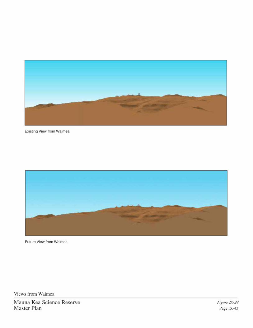
Mauna Kea Science ReserveMaster Plan
Figure IX-24
Page IX-43
Views from Waimea
Existing View from Waimea
Future View from Waimea

Mauna Kea Science Reserve Master PlanPhysical Planning Guide Page IX - 44
Planning Guide Summary and Approval Process for Astronomy Precinct
A list of the existing and proposed future observatories for which there are identifiedsiting areas in this master plan is shown on Table IX-1 (page IX-45). The likelihood of allof the identified facility upgrades and proposed new facilities being developed isextremely remote, and the expected scope of development is 50 to 75 percent of theobservatories listed. The timing for future development is undefined at present, except forthe Keck Outriggers project. For some of the proposed new projects, significanttechnological advancements are needed before they could move forward. This isparticularly true for the Next Generation Large Telescope.
As described in Chapter XI, the University of Hawaiÿi Board of Regents and thePresident retain project approval and design review authority over all developmentswithin the Science Reserve. To assist the University in its evaluation of proposed newdevelopment, all applications will be reviewed by the Office of Mauna Kea Management,the Mauna Kea Management Board, and the Kahu Küpuna Council (see Figure XI-2,page XI-8). In making any decisions on project approval, the Board will carefullyconsider the advice received from the above three groups.
Each of the redeveloped or proposed new facilities, including any non-astronomyfacilities, will undergo individual project reviews, which include an environmentalanalysis pursuant to Chapter 343 Hawaiÿi Revised Statutes and a comprehensive analysisof the potential cultural impact. The Kahu Küpuna Council will assist in establishing thecriteria for these analyses. It is expected that some of the criteria will be specified byState requirements.
In addition, each new facility will be required to present a detailed justificationaddressing, but not limited to, questions such as the following:
(1) Why is the facility needed?
(2) Why is Mauna Kea the best site for the facility?
(3) What other location options are available?
(4) What are the expected benefits: research and education, employment and economicactivity, potential revenues?
(5) What is the expected facility lifetime and term of the sublease agreement?

Mauna Kea Science Reserve Master PlanPhysical Planning Guide Page IX - 45
Table IX-1
EXISTING AND PROPOSED OBSERVATORIES ATMAUNA KEA SCIENCE RESERVE
Observatory (Aperture Diameter) Proposed Master Plan Action
University of Hawaii (0.6 m.) Redevelop: 2-3 m.
University of Hawaii (2.2 m.) Redevelop: 4-12+ m.*
Canada-France-Hawaii Telescope (3.6 m.) Redevelop: 4-12+ m.*
United Kingdom Infrared Telescope (3.8 m.) Redevelop: 4-12+ m.*
NASA Infrared Telescope Facility (3.0 m.) Redevelop: 4-12+ m.*
Caltech Submillimeter Observatory (CSO) (10 m.) Remain As-Is
James Clark Maxwell Telescope (JCMT) (15 m.) Remain As-Is
Very Long Baseline Array (VLBA) (25 m.) Remain As-Is
W. M. Keck Observatory (Keck I & II) (10 m.) Add 4-6 1.8 m. Outrigger Telescopes
Gemini Telescope (8 m.) Remain As-Is
Subaru Telescope (8 m.) Remain As-Is
Submillimeter Array (SMA) (12 6-m. Antennas) Add 12 Antennas
New: University of Hawaii – Hilo New Site, 1 m. (Instructional)
New: Conventional Optical/IR New Site, 4-12+ m.*
New: Next Generation Large Telescope (NGLT) New Site, 25+ m.
Note: All new and redeveloped facilities require individual project review and approval.The NGLT will require the development of new technology.
* It is expected there will be a range of telescope sizes proposed in this group. Exterior dimensions ofthose on the ridge will be limited by Design Guidelines.

Mauna Kea Science Reserve Master PlanPhysical Planning Guide Page IX - 46
RECREATION PLAN COMPONENTS
The final integration of the Master Plan involves the recreational resource components inthe Science Reserve. This plan provides direction for future recreational uses within theScience Reserve, including any potential facilities to support recreation on Mauna Kea.Recreation components, such as hiking, hunting, skiing, snow play and tourism, areaddressed in an integrated approach overlaid upon the integrated plan of natural andcultural resources and education and research resources. The overall objectives forrecreational resources are listed below.
Overall Objectives
1. Expand understanding of recreational uses and potentials of the Science Reserve.
2. Retain and enhance recreational opportunities within the Science Reserve, whileprotecting natural, cultural resources, and cultural practices.
3. Define areas, criteria and support facilities for recreational uses, sight seeing andcommercial tours, as applicable, to allow for sustainable, integrated planning andmanagement.
Recreational Resources Plan. The traditional uses for recreation on Mauna Kea, and thepattern of these uses, determines the form of the recreational plan component. Access torecreational resources will be enhanced and managed to ensure the protection of thenatural, cultural, education and research resources. Hiking trails, ski areas and scenicviewpoints will be delineated within the Science Reserve to allow people to witness theunique resource areas while ensuring their protection. As part of the plan, the followingfacilities are planned:
• Recreational support facility in the summit region to support skiing, snow play,visitor tours and scenic resource enjoyment;
• A parking area that is primarily planned to serve cultural resource interests, locatedalong the access road at the 13,000 ft. elevation; and
• Cabin camping by organized groups, using the planned conversion of the constructioncabins built by the Subaru observatory at Hale Pöhaku.
Further details of the Recreational Plan elements are discussed in the following section.

Mauna Kea Science Reserve Master PlanPhysical Planning Guide Page IX - 47
Physical Plan: Expanded Understanding of Recreational Resource
While there are physical components to the recreational plan, most recreational issues areaddressed in the management plan. There are modest facilities needs for recreationalsupport, and support facilities to serve the cultural resource component overlap in certaincases.
Skiing and Snow Play. Skiing and snow play activities are very popular recreationaluses of Mauna Kea during periods of winter snowfall. Figure IX-25 shows the extent ofpopular ski runs and snow play areas in the summit area. It is also proposed that skiingand snow play use be restricted from the significant cultural landform of Puÿu Poliÿahu.Snow play activities are centered around the Poi Bowl area. Snow play will also berestricted to areas without archaeological sites and cultural preserve areas. Parking andbathroom facilities are existing needs to support skiing and snow play activities.
A recreational support facility is planned within the summit region to support skiing,snow play, visitor tours and scenic resource enjoyment. The support facility is planned tobe located at the base of “Poi Bowl” along the summit access road in Millimeter Valley,at the center of skiing and snow play activity at the summit during winter months. Thefacility would include a shelter, rest rooms, emergency equipment storage, an emergencytelephone, and possibly a small office space for the rangers. The design of the facility isenvisioned as a building built into the surrounding landscape such that its presence willnot detract from its natural setting. It is not to be a “ski lodge”.
Individual Visitors and Tours/ Scenic Vista Out-Look Locations. The master plandefines areas for specific visitor stopping points in the Science Reserve and at thesummit. Scenic lookout points will be organized at the summit at two locations wherethe observatories are willing to accommodate limited public access. Currently the Keckobservatory sites allow such use, with the Keck Observatory providing a Visitor’sGallery including restrooms. Very limited parking areas are present to serve the visitorareas, and visitors will generally be directed to use the restroom facilities planned for thePoi Bowl area.
Trails. In the rugged terrain in the upper slopes of Mauna Kea, trails to Waiÿau and thesummit are evident on historic maps and on the ground today. Past ranching activitieswere responsible for creating the more defined trails. Interviews of informants withhistorical knowledge of Mauna Kea identified the routes of historical trails (Figure V-4).
The plan is to preserve the existing historical trails to Waiÿau and the summit. To protectthe resources of the Science Reserve, formal public hiking routes within the ScienceReserve will be mapped in the future, and trail improvements will be planned as neededfor safety. A recreational support facility, including a parking lot and restrooms, isplanned for the Millimeter Valley area and will be available to hikers and other users.

12750
12700
12675
12725
12775
12725
12775
12750
12800
12825
12850
12875
12925
12900
1285
0
12925
12875
12950
12975
13000
12975
12950
12975
12950
1297
5
13000
12925
12900
12975
12950
13000
13025
13050
13075
13100
13125
13175
13225
13275
13325
13350
13275
13250
13300
1325
0
13300
1325013225
13275
13325
1332
513350
13350
1357
5
13375
13600
13450
1355
0
13400
13550
13500
13475
1337513425
1352513575
13575
13375
13400
13425
13475
13525
13575
13075
1305013025
13000
12975
12950
12900
1310
0
1322
5
1317
5
13200
1315
0
1312
5
13075
1292
5
1297
512
950
12825
1280
012
850
1290
0
12875
12875
13225
13250
13350
1330013275
13175
13200
13150
13125
13050
12950
13100
13075
12925
13025
13000
12975
12925
1290
0
13450
1355
0
13500
13400
12825
1272
512
70012
675
1265
0
1277
5
1275
0
1257
5
1262
5
12600
12725
1280
0
12775
12700
12650
12625
12600
12750
12675
12825
12800
12775
12750
1287512850
12725
1270
0
13325
12800
12775
12750
12975
12825
12875
12850
12900
12925
12950
13125
13000
13025
13050
13075
13100
13150
13175
13200
13225
13250
13275
13300
12600
1262
5
1265
0
1290
0
13450
1277
5
13350
1287
51290
0
1280
01282
51285
0
1297
5
1315
0
1317
5
1300
0
1302
5
1305
0
1307
5
1310
0
1312
5
1320
0
1292
51295
0
12925
12900
1295012975
13000
1272
5
12675
12700
12750
12750
12775
1280
0
1282
5
1285
0
12775
12875
1372
5
13675
13375
13425
135251355013575136001362513650
13450
13400
1347513500
1375
013700
1372
5
1375
0
13700
1370
0
13725
1370013675
13625
13600
13575
13550
13650
13150
13125
13075
13350
13300
1332513350
13150
13125
13100
13200
13325
13300
13275
13250
13225
13175
1320013225
13250
13275
1312513150
13175 13025
13050
13075
13100
13050
13075
13100
13050
13025
12975
12950
13000
12925
12900
12875
12950
13000
12975
1295012975
13025
13075
1297
512
9501292
5
1310
01305
01300
0
12825
12775
12800
12875
12850
12900
12875
12850
12825
12800
13425
1352513500
1347513450
13400
13375
13425
1337513400
12725
12800
12825
12775
12750
12850
12700
12675
1275
0
1282
51280
0
1277
512
875
1285
0
1272
5
1270
0
12675
Mauna Kea Science ReserveMaster Plan
Figure IX - 25
Page IX - 48
Existing Ski Areas
Ski Areas
25' Contour Intervals
Natural Area Reserve
Source: 1983 Mauna Kea Science Reserve Complex Development Plan, Dr. Jerry Johnson, 1998
0' 750' 1500' NORTH0' 750' 1500' 3000' NORTH
United Kingdom Infrared Telescope(UKIRT)
JamesClerk
MaxwellTelescope
(JCMT)
NARSubmillimeter
Array
Pu’u Poli’ahu
CaltechSubmillimeterObservatory
(CSO)
Subaru
W.M. Keck Observatory
NASA Infrared Telescope Facility(IRTF)
Canada-France-Hawaii Telescope(CFHT)
Gemini Northern 8-M
University of Hawaii 2.2-M
MAUNA KEAICE AGE
NATURAL AREA RESERVE
III
Kükahauÿula
Wai‘au
UH 24"
CJ ~ E3

Mauna Kea Science Reserve Master PlanPhysical Planning Guide Page IX - 49
Another support facility is a parking area that is primarily planned to serve culturalresource interests, located along the access road at the 13,000 ft. elevation. This locationwill provide access to existing trails leading to Waiÿau and the adze quarry. These usesare directed to defined areas of the Science Reserve to protect the sensitive natural andcultural resource components. Development of this support facility will be subject toapproval by the DLNR.
Camping. The public will also benefit from the planned conversion of the constructioncabins built by the Subaru observatory at Hale Pöhaku. These will be turned over afterconstruction operations cease (2001) and become available for public group stays.
Hunting. Hunting activity in the Science Reserve generally only occurs in the lower andmid-elevations of Mauna Kea. Hunting areas are shown in Figure VII-1. Access forhunters is available through Hale Pöhaku and Puÿu Laÿau. The Master Plan places nonew restrictions on the future use of the Science Reserve for hunting.
Recreational Physical Plan. The recreational use elements of the Science Reserve aredepicted as broad use areas for skiing, snow play, hiking and hunting. Specificlandforms, such as Puÿu Poliÿahu have been designated as off-limits for futurerecreational use to respect the cultural significance of this puÿu. The plan includesinformational signage for visitors such that a well-planned tour can be conducted withoutrandom stopping points that can result in adverse effects to important natural and culturalresources.
Overall Physical Planning Guide for Summit
An overall plan of the summit region is shown in Figure IX-26. The physical planidentifies all of the locations for existing and proposed astronomy facilities in theAstronomy Precinct. Also shown in the plan is the location of the recreational supportbuilding within the Precinct. This plan depicts a composite of all resource componentsinto one integrated plan. Natural and cultural resources elements are preservedthroughout the Science Reserve, with particular focus on the 10,760-acre Natural andCultural Preservation Area surrounding the proposed Astronomy Precinct. Proposedfacilities to support education/research and recreational elements are limited within theapproximately 525-acre Astronomy Precinct.

Mauna Kea Science Reserve Physical Plan
Mauna Kea Science ReserveMaster Plan
Figure IX-26Page IX-50
0' 2000' 4000' 8000' NORTH
40' Contour Intervals
NATURAL/CULTURALPRESERVATION AREA
10,760 Acres
NAR
NAR
SMA Expansion
RecreationSupport
ConventionalOptical/IR
RedevelopedOptical/IR
Keck Outriggers
Open Viewto Westfrom Summit
UH &UHH
ASTRONOMYPRECINCT
525 Acres
SMA Expansion& NGLT
Mauna Kea Science Reserve Master PlanPhysical Planning Guide Page IX - 51
PLAN FOR HALE PÖHAKU MID-ELEVATION FACILITIES
The mid-elevation facilities at Hale Pöhaku have typically been associated with support ofastronomers, dating back to times when all facilities were operated by on-mountainastronomers and technicians. With today’s technology and the fiber optic communicationssystem, many of the studies occurring at these observatories can be operated remotelyeither from Hale Pöhaku, off-mountain Hawaiÿi locations (Waimea, Hilo), or via theInternet. Hale Pöhaku’s role in providing public information and education aboutastronomy on Mauna Kea will be augmented by these base facilities and a plannedplanetarium in Hilo. Refer to the following section for additional detail regarding the off-mountain base facilities.
Even with the change in operating procedures, portions of the Hale Pöhaku facilities arebeing planned to accommodate increased non-astronomy use in the next 20 years. Thereare three components to the Hale Pöhaku facilities that are addressed in the plan, including:1) Astronomy mid-elevation facilities, 2) Construction camp facilities, and 3) the VisitorInformation Station facilities. Existing facilities at Hale Pöhaku, and uses planned at theselocations, are described below and shown in Figure IX-27.
1. Astronomy Mid-Elevation Facilities. Due to the increased capability for off-mountainviewing, use of the existing astronomy mid-elevation facilities has been declining, andthis trend is generally anticipated to continue or stabilize near current levels. As thetotal number of observatories on the summit will be increasing, overnight stays at themid-elevation facility will generally decline on a per facility basis. This will result in atotal number of overnight stays that is anticipated to be comparable to the presentlevels, therefore there will be no need for expansion.
2. Construction Camp Facilities. The older camp facilities are to be removed. TheSubaru construction cabins will become fully available to the State in 2002. Thesecabins are proposed to be used for additional purposes including education, researchand recreation, including:• Increased use by University of Hawaiÿi at Hilo, other college/university-level
academic programs relating to geology, alpine and mountain forest ecology,astronomy and Hawaiian culture, as well as groups from schools and organizations.
• Periodic temporary lodging for observatory construction crews for future projects.
3. Visitor Information Station Facilities. The visitor center facilities will require furtherexpansion, which will complement the planned programs at UH-Hilo. A visitorinformation center will be included in the facility. Other possible uses could includenatural and cultural resources interpretive center, and the ranger station offices andcommunications center. The new controlled access point on the summit road will occurat the Visitor Information Station, replacing the present (open) gate located at theastronomy mid-elevation facility. Current plans for the Visitor Information Stationexpansion include an auditorium addition and new observatory. The anticipated usersof the Visitor Information Station are described below in several categories.

9140
9150
9160
9170
9190
92009210
9220
9230
9240
9250
9260
9270
9280
9300
9320
9330
9180
WATER TANKS
EXISTINGSTONE CABINS
ACCESSMANAGEMENT POINT
EXISTING VISITOR CENTER
AUDITORIUM EXPANSIONTELESCOPE EXPANSION(20” TELESCOPE)FUTURE RANGER STATION
FUTURE FACILITIES AREAEDUCATION/ RESEARCH
EXPANDED PARKING(59 EXISTING & ±75 NEW)
EXISTING ASTRONOMYMID-ELEVATION SUPPORT
FACILITIES
EXISTING GATE
EXISTING SUBARUCABINS FOREDUCATION/OTHER USES
ARBORETUM
EXISTING DORMSTO BE DEMOLISHED
Mauna Kea Science ReserveMaster Plan
Hale Pöhaku Plan
Figure IX - 27
Page IX - 52
Existing Structures to Remain
Existing Structures to be Demolished
Stone Cabins
Expansion Elements
Expanded Parking Lot
CJ []]] ~
··-··-··-··-··-··-l . . I . .
I . . ··-··-··-··-··.J

Mauna Kea Science Reserve Master PlanPhysical Planning Guide Page IX - 53
• Visitors attracted or directed by the planetarium program at UH-Hilo’s UniversityPark. People visiting the planetarium will learn about the Hale Pöhaku facilities,and some will visit the Mid-Elevation facilities for a first-hand experience of themountain’s cultural and educational resources.
• Private tour groups and individual travelers are also expected to travel to HalePöhaku in greater numbers. With the improvement of the Visitor InformationStation, its reputation will grow and people’s interest in witnessing the facility andexperiencing its programs about the mountain will expand. A 20-inch telescopewill be installed at the VIS so the visitors and amateur astronomers can observe thesky in Mauna Kea’s superior conditions. Other public astronomy facilities may alsobe developed in the future. All improvements at Hale Pöhaku are subject to designreview.
• Non-astronomy research groups (e.g. geology, botanical, faunal, cultural, etc.) willalso increase over time. These types of groups will travel to the Visitor InformationStation to experience exhibits and programs highlighting the unique natural andcultural resources of the mountain.
• Recreational use by naturalists and cultural groups will expand. Individuals andorganizations are anticipated to utilize the Visitor Information Station for their ownrecreational enjoyment or for organized functions.
• Primary-level educators will utilize the Visitor Station for school field visits andeducational programs (e.g. geology, botanical, faunal, cultural, etc.)
The anticipated increases in use will create the need for additional parking area at the HalePöhaku Visitor Information Station. The number of parking spaces is currently planned toincrease by 75 spaces to a total of approximately 150 spaces. More parking may be neededat the Visitor Center in the future.
The number of travelers to Hale Pöhaku utilizing Saddle Road and the Mauna KeaAccess Road is expected to increase in the future. Future improvements planned forSaddle Road by Hawaiÿi County will also allow for better access to Hale Pöhaku. MaunaKea Access Road is not currently planned for improvements. However, future use levelsat the Visitor Information Station may warrant additional work such as increased signage,new pavement and striping, and minor widening of pavement for paved shoulders.
OFF-MOUNTAIN BASE FACILITIES
It is difficult to conduct research investigations for prolonged periods at the high altitudelocations of the Mauna Kea summit or Hale Pöhaku. In addition, it is difficult to accessthe observatories in harsh winter weather periods. Several observatories have found itmore effective to conduct their studies from off-mountain base facilities. With theinstallation of fiber optic communications to the observatories on Mauna Kea, they nowhave the capability to be operated remotely. Off-mountain base facilities for theseobservatories have been established in Waimea (CFHT and Keck) and University Park in
Mauna Kea Science Reserve Master PlanPhysical Planning Guide Page IX - 54
Hilo (UKIRT, JCMT, CSO, Subaru, Gemini, and IfA). The trend toward providing off-mountain base facilities is expected to continue.
Some facilities, such as the Submillimeter Array (SMA), can be operated remotely viathe Internet from its home base in Cambridge, Massachusetts. SMA also has offices inHilo from which it conducts its current operations in Hawaiÿi. Future telescopesconstructed at Mauna Kea will be encouraged to develop their base facilities in Hawaiÿito the greatest extent practical.
Future observatory construction at Mauna Kea may require additional base facilities to beconstructed in either Waimea or Hilo. The most recent base support facilities have beendeveloped at University Park on the campus of UH-Hilo. In addition, UH-Hilo proposesto locate the Mauna Kea Astronomy Education Center, an educational and interpretivefacility designed to broaden, public understanding of the Universe, at University Park, asnoted in Appendix B.
INFRASTRUCTURE REQUIREMENTS
Infrastructure elements serving the Science Reserve will require periodic updating andexpansion to serve the various users of the mountain in the next 20 years. Education andresearch facilities within the Astronomy Precinct will have facility requirements forupdating and expansion of roadways, communications system, and electrical powersupply. Infrastructure maintenance will be an ongoing requirement, which is addressedin the management plan.
Roadways. Roadway expansion will be minimized through the development sitingcriteria, which guides future facilities to be developed near the existing roadways. Theexisting unimproved roadways serving the expansion sites within the Astronomy Precinctwill require additional improvement. Although there are narrow road alignments present,these roads will require modest widening and grading to make them passable for newfacilities operations located beyond the existing astronomy areas at Millimeter Valley andthe summit ridge. The Master Plan recommends paving of the remainder of the accessroad from Hale Pöhaku and the remainder of the summit spur road which runs from theSMA building past the Subaru Telescope to the W.M. Keck Observatory. Paving willreduce the amount of dust generated by vehicles, thus improving conditions forastronomy observations and for Wëkiu habitat.
Communications and Power Supply. The fiber optic communications system and theelectrical power system will be expanded to serve new facilities sites to the north andnorthwest. The main power supply to the mountain is adequate to serve the additionalfacilities anticipated under this plan. To minimize the visual impact of new utility pullboxes to be located along the new underground conduit routes, colored concrete will beused to match the surrounding ground surface.

Mauna Kea Science Reserve Master PlanPhysical Planning Guide Page IX - 55
Water Supply. There is no water supply extending to the summit of Mauna Kea, andfuture water supply to the summit will continue to follow current procedures. Water willcontinue to be provided from two 40,000-gallon water tanks located at Hale Pöhaku.Currently, 25,000 gallons of water are trucked to the mid-level facility from Hilo eachweek. Each of the observatories will continue to be supplied with potable water that istransported to the summit by tanker trucks from Hilo. About 15,000 gallons of water ispresently trucked to the summit each week, and each facility has its own water storagetank. The supply rate will increase to serve new facilities that are planned for thesummit. Changes to technology allowing remote (off-mountain) viewing access couldreduce the number of workers and scientist actually present at new facilities, and acorresponding lower water use rate as compared to existing facilities.
Wastewater Management. There is no plan for construction of a sewer collection systemto serve the summit area. Wastewater generated at the observatories will continue to bemanaged by each facility through individual wastewater disposal systems (cesspools andseptic tank/leaching field systems). Due to the small number of workers and visitorsutilizing these facilities on a daily basis, the volume of water use and wastewatergeneration is small, approximating domestic rates. Changes to technology allowingremote (off-mountain) viewing access could reduce the number of workers and scientistactually present at new facilities, and a corresponding lower water use and wastewatergeneration rates.
Drainage. Erosion due to storm water runoff will be controlled on all new roadways,such that there will be no adverse affects to the surrounding landscape. There are sixculverts within the 4.5 miles of roadway from Hale Pöhaku to the summit. Culverts willbe installed as needed along the extension of the access roadway system to the north tominimize erosion
Summary of Physical Planning Guide for the Science Reserve and Hale Pöhaku
The overall physical planning guide for the Science Reserve depicts a composite of allresource components into one integrated plan. Natural and cultural resources elementsare preserved throughout the Science Reserve, with particular focus on the 10,760-acreNatural and Cultural Preservation Area surrounding the proposed Astronomy Precinct.Proposed facilities to support education/research and recreational elements are limitedwithin the approximately 525-acre Astronomy Precinct, except for improvements tofacilities at the Hale Pöhaku Visitor Center.
This updated physical plan, in conjunction with the updated Management Plan (discussedin the following section), creates a living planning and management document that hasbeen developed in collaboration with the University, Mauna Kea Advisory Committee,native Hawaiian interests, and other stakeholders and interested community members.

MAUNA KEA SCIENCE RESERVE MASTER PLAN
X. MANAGEMENT PLAN

Mauna Kea Science Reserve Master PlanManagement Plan Page X- 1
MANAGEMENT PLAN
I. MANAGEMENT PLAN OBJECTIVES
The experience of the last three decades has shown the need for re-examination of theexisting management procedures. The lessons from this experience are summarized inthe following clusters of management objectives:
A. To create a structure for sustainable, focused management of the resources andoperations of the Mauna Kea Science Reserve in order to:
• Protect historic/cultural resources: e.g. archaeology sites, traditional culturalpractices. While actual damage to known archaeological sites has been minimal,there has evolved a greater sensitivity to cultural values and the importance ofgeophysical forms in the cultural landscape. The proposed management planincorporates these values and sets up a supportive framework for current,traditional Hawaiian cultural practices. It proposes a framework for assessing theimpact of current practices on historic sites, natural resources and other uses onthe mountain. If there are conflicts, the management plan would establish aprocedure for resolving disputes. The plan also promotes education and furtherresearch in ethnography and related disciplines.
• Protect natural resources: e.g. Wëkiu habitat, alpine ecosytem. The naturalresources that should be protected begin with the mountain’s geology andatmospheric qualities. These form the base for the unique ecosystems that makeup the Science Reserve, Summit Road corridor and Hale Pöhaku. Tropical islandalpine environments are extremely rare on the planet. The value of the mamaneforest has been recognized in all plans. The passage of years has only reinforcedthe importance of this ecosystem. The impetus from the planning for astronomyand other activities has provided us with studies that have given us greaterunderstanding of the uniqueness of the Wëkiu and other endemic species. Thisincreased understanding has provided more information on potential protective andmitigative measures.
• Protect and enhance education and research: e.g. astronomy, Hawaiianlanguage and culture, archaeology, ecology, geology. The continued recognitionof the importance of astronomy in the Mauna Kea Science Reserve remainscritical. Its economic impact to the island is significant. Mauna Kea’s globalimportance has grown over the last twenty years until it is now recognized as oneof the premier viewing places in the world. The qualities that make Mauna Keasuch a desirable site need to be preserved. Facility and infrastructureimprovements must continue for the complex to retain its continued prominence inthe field.
Mauna Kea Science Reserve Master PlanManagement Plan Page X- 2
Knowledge about the potential for other research disciplines has grown. MaunaKea has many qualities and resources that make it a great outdoor laboratory andclassroom for Hawaiian language and culture, archaeology, ecology, biology,geology and a host of other disciplines. This is recognized in the plan by theencouragement of joint use of support facilities and the identification of these otherdisciplines as important overall goals. Education is a major function of the State ofHawaiÿi and the University. The value of the mountain for educational purposeswith particular emphasis on K-12 and post-secondary programs for nativeHawaiian students, is recognized and incorporated in the use concepts for themountain. The proposed management plan recognizes this greater diversity ofinterests.
• Protect and enhance recreational opportunities: e.g. hiking, snow play andskiing. Recreational opportunities are an adjunct to the existence of the naturalresources of the mountain. The proposed plan recognizes the importance ofrecreational values by identifying it as a separate resource cluster. Proposedmanagement plans hope to address the anticipated growth in recreational useswhile protecting the resources.
• Promote public safety. Improved access and growing numbers of visitors andvehicles raise concerns about public safety. This is already a problem withaccidents and injuries; especially on the Summit Road. The plan proposes variousmeasures to increase public safety.
B. To create a structure which meets the following objectives:
• Promote community input. The inadequacy of opportunities for public input hasbeen a long standing issue. The proposed plan addresses the issue with thecreation of a new management structure and review procedures for amendmentsand proposals that include public participation.
• Establish local management. The need and sentiment for local management hasbeen clear. The plan addresses this question with the creation of a managementbody located on the Big Island.
• Establish a focal point for management responsibility. For the general public,multiple jurisdiction has created vagueness and confusion in responsibility,authority, communication and policy. The need for a focal point of managementresponsibility and contact has became clear. The plan addresses this goal bycreating a single entity as a hub for activity and management on the mountain.
• Establish clear lines of decision making and accountability. Within responsibleagencies, lines of authority and communication must be clear. The proposedmanagement structure must increase the accountability of all parties on themountain and make sure each agency is aware of its responsibilities.

Mauna Kea Science Reserve Master PlanManagement Plan Page X- 3
• Economic and structural feasibility. Funding for management has beeninadequate. The proposed plan focuses on changes that can be achieved withoutstatutory changes to existing regulations and responsibilities. Managementfunctions would become a part of a funded function of the University supported bythe Board of Regents.
• Provides a base for future expansion of the scope of activities in the ScienceReserve. It is anticipated that activities supported in the Science Reserve willexpand beyond astronomy to include a variety of other areas such as culturalpractices, sports/recreation, education, other academic areas and environmentalprograms. The proposed plan provides a structure designed to manage these variedactivities under a single management entity.
The management objectives and the proposed management plan evolved after manyMauna Kea Advisory Committee meetings and discussions with key individuals from theUniversity of Hawaiÿi, Department of Land and Natural Resources and the community.Many alternative management structures were proposed, discussed, revised and/ordiscarded. The management plan delineated here addresses the issues mentioned inChapter XIII and meets the objectives listed above. It can be implemented quickly with aminimum of consent or approval outside of the current University of Hawaiÿi system.The plan calls for the creation of a management organization capable of providing thenecessary stewardship for the sustainable use of Mauna Kea. The structure can alsoevolve to take on more responsibility and authority as needed. The plan also considersthe integrated nature of the resources and establishes clear relationships with the adjacentNAR and other DLNR lands.
II. MANAGEMENT ORGANIZATION AND PROCEDURES
Three levels or tiers of responsibility comprise the structure at Mauna Kea: landownership, policy setting/regulatory compliance, and management. The following isproposed:
Management Organization Proposal: There is a need for a single entity to manage acomprehensive integrated plan for the Mauna Kea Science Reserve. This managementorganization should be based on the Big Island and recognized by the general public asthe point of contact for the summit region. It could be housed within the University ofHawaiÿi system and funded as a separate, ongoing program unit out of the University ofHawaiÿi at Hilo ( See Figure X-1). Housing it within a permanent unit of the UH systemmakes a clear statement that the University accepts the responsibility for this function,including its funding.
A suggested name for the organization is the University of Hawaiÿi Office of Mauna KeaManagement (UH MKM or Office). It is also proposed that a Mauna Kea ManagementBoard be recommended by the UH Hilo Chancellor and appointed by the Board ofRegents to guide the operations of the UH MKM. This Board will be advisory

Mauna Kea Science ReserveMaster Plan
Figure X-1
Page X-4
Board of Regents
MK ManagementBoard
University ofHawai‘i Mänoa
University of Hawai‘iWest O‘ahu
University of Hawai‘iPresident
CommunityColleges
University of Hawai‘iHilo
AdministrationAcademic
AffairsUniversityRelations
StudentAffairs
UH-MKM
University Park
DirectorAdministration
4 RangersVIS AdministratorMaintenance Staff
Office of Mauna Kea Management Position in UH System
I I I -
I I I I ------------------------

Mauna Kea Science Reserve Master PlanManagement Plan Page X- 5
to the Chancellor. It is further proposed that the Office be housed within the unit for UHHilo which is projected to manage the University Park. The Office should be responsiblefor the management of the Science Reserve, Summit Road and Hale Pöhaku. It would beresponsible for establishing and enforcing management policies within the parameters ofGeneral Lease S-4191. The Office would be the focus of contact for the general publicand would function as a referral and facilitative agency for issues that are outside itsauthority but related to the mountain.
It is projected that the UH MKM would have an initial staff which includes a director,administrative assistant, mountain rangers and general maintenance and support staff(Refer to Figure X-2). For general maintenance and support services, except forfunctions retained by IfA for existing leases and agreements, most of the current MaunaKea Support Services could be transferred to the UH MKM. This transfer would beprojected to occur over time after the updated master plan is adopted by the Board ofRegents and the new structure is implemented.
Within the UH system, the director would have overall management responsibility for theOffice. The director would be the key representative of the Office and the daily point ofcontact for the general public and tenant organizations on the mountain and at UniversityPark. Any permitting and rental arrangements that may be established could be processedthrough UH MKM. Except for facilities managed by IfA at Hale Pöhaku for astronomysupport, scheduling and requests for use of facilities or support services should beprocessed through the director. The Office would also address other requests, grievancesand requests for information. Monitoring programs and databases would be coordinatedthrough UH MKM to provide integrated management of the mountain.
Rangers, located at Hale Pöhaku, should be trained as cultural and natural resourcespecialists and it is recommended that some of the ranger staff be bilingual Hawaiian andEnglish speakers. Their primary role would be education, coordination, monitoring andresource management. They would have a secondary enforcement role with possibleassistance from DLNR DOCARE officers and County of Hawaiÿi police. It is envisionedthat there would be a minimum of two rangers on the mountain at any time; one at HalePöhaku managing the entrance and one roaming in the Science Reserve. The ranger atHale Pöhaku should register and orient visitors and coordinate programs that may beoccurring at the Visitor Information Station (VIS) or other parts of the mid-elevationfacilities. The ranger that is roaming would monitor people activity and make periodicfield checks in resource areas. They would assist with safety and emergency procedures.Rangers would assist and educate visitors at all times. Rangers should monitor all fieldactivities in the summit area from sports activities to volunteer rubbish sweeps andoutdoor educational programs.

Mauna Kea Science ReserveMaster Plan
Figure X-2
Page X-6
Organization Chart
University Park/Science Reserve Unit
Executive DirectorUH-MKM Director
UNIVERSITY OF HAWAI‘I - HILOChancellor
Maintenance& Support
MAUNA KEAMANAGEMENT BOARD
AdministrationHale Pöhaku
Non-AstronomySupport
Field Service
RangersVisitor
InformationStation
ProgramsCommunityRelations Hale Other
CabinsUtilities
SnowRemoval&Trash
RepairMainte-nance
POSSIBLE FUTURE INCORPORATION
Kahu KüpunaCouncil
...__
1 L. -----------------------
1 ✓-------------------------------I '
I I
I I I I I I I I I
II I ' I
--------------------------✓

Mauna Kea Science Reserve Master PlanManagement Plan Page X- 7
General maintenance and research support services are currently provided by Mauna KeaSupport Services (MKSS). At present these functions include:
• Food and lodging at Hale Pöhaku;• Gas, diesel and water to existing astronomy facilities and their staff;• Provision of utility support services, including trash removal;• Safety and emergency services;• Road maintenance and snow removal;• Visitor Information Station services and manpower;• Library and office services at Hale Pöhaku;• Maintenance of the communications network;• Servicing the construction camp.
After negotiations with IfA and current tenants, portions of MKSS functions, budget andpersonnel would be transferred to the MKM and become a permanent part of the newmanagement organization. Existing agreements specify IfA involvement in the provisionof specific utility services and support functions and any transfer of responsibilitieswould be contingent on agreement from existing sublease holders.
Hale Pöhaku: The mid elevation facilities at Hale Pöhaku are projected to accommodatemuch of the anticipated growth in facilities and programs for astronomy education andnon-astronomy purposes. As the facility expands with new equipment and spaces,program specialists in education, culture and natural resources may be added to the staffas funding increases. These specialists would assist in program development andcoordination and may be accommodated at either Hilo or Hale Pöhaku. New programs inculture, Hawaiian language, geology, biology, ecology, habitat restoration and others arepotential areas of growth. These programs may have field, classroom and distancelearning components. Facility and infrastructure support may be provided in the ScienceReserve, at Hale Pöhaku or elsewhere.
Community Involvement: Mauna Kea is a community resource. Communityinvolvement in the management of the mountain begins with the membership of theMauna Kea Management Board. The Board should be composed of membersrepresenting the major stakeholders of Mauna Kea.
The Board’s primary role is to advise the Office of the Chancellor at UH Hilo onmanagement of the Mauna Kea Science Reserve. The Board should be the maincommunity voice for activities and development planned for the Science Reserve. TheBoard would be a public forum for future uses, activities and development on themountain. Finally, the Board could act as a facilitator during grievance procedures andassist in the resolution of conflicts.
The Board is encouraged to establish special committees on culture, environment andeducation, as needed, to assist it in its functioning. For cultural issues the Burial Council
Mauna Kea Science Reserve Master PlanManagement Plan Page X- 8
model is suggested. The Burial Council is a group of appointed citizens which providesguidance on the disposition of human remains. A special Kahu Küpuna Council made upof representatives of native Hawaiian organizations as well as individuals recognized fortheir specialized knowledge could function like the Council. Other special advisorycommittees may be formed for environmental and education issues. These committeescould focus on docent and other programs for Mauna Kea.
Docent programs are suggested to expand knowledge of the mountain and to encouragegreater community participation. Docents could teach visitors about the rich andcomplex resources of the mountain. Volunteer organizations and alliances are alsoencouraged in order to broaden the pool of people who value and support the stewardshipof the mountain. These groups could be called upon for various functions such as theperiodic maintenance sweeps, special programs or fund raising events. Groups should beencouraged to “adopt the mountain”. The UH MKM should encourage and coordinatecommunity participation.
Grievance Procedures: The MKM should establish grievance procedures to addressissues as they arise. All grievances should be presented to the director of the Office whowill make an assessment about the appropriate resolution of the issue. If the issuesrepresent broad plan or policy questions beyond the management authority of the MKM,the director should refer the questions and/or questioner to specific contacts at theappropriate agencies; usually the DLNR or the UH Board of Regents. The Office shouldfollow the progress of the grievance and assist where it is able. Where the grievance isabout management issues or items within the jurisdiction of the Office, the director willreceive and respond to the questions. If the issue requires management or rule changesby the Office, the director will research the question and bring it before the ManagementBoard for review. All grievances should be handled in a sensitive and timely manner.
Coordination and Other Agencies: A major role for the Office of Mauna KeaManagement will be its role in coordinating actions that are peripheral to itsresponsibilities but still important to the management of the mountain. This is becauseauthority on the Mountain is distributed among many governmental entities. Besides theUniversity of Hawaii, the Department of Land and Natural Resources retains a major rolein management of the mountain. The Office will communicate issues and concerns that itreceives to the appropriate agencies and follow through in their resolution.
It needs be re-emphasized that while the University of Hawaii has the master lease for theScience Reserve, the Board of Land and Natural Resources holds the title to the lands thatmake up the summit of Mauna Kea. In the master lease, DLNR specifically reserved itsauthority over activities that are not related to the educational and research mission of theUniversity of Hawaii. Even in the Science Reserve, DLNR is still the primary agencyresponsible for protection of natural and cultural resources, managing recreationalactivities such as hunting and hiking, as well as controlling commercial uses. Theseresponsibilities are written into the Hawaii Revised Statutes and cannot be delegatedwithout legislative or constitutional action. Of special importance is the DLNR authority

Mauna Kea Science Reserve Master PlanManagement Plan Page X- 9
and responsibilities related to historic sites and cultural practices. These responsibilitiesremain with DLNR and are not delegated through the master lease.
Other lands related to the management of the summit of Mauna Kea are under thejurisdiction of DLNR and DHHL. The two natural area reserve areas which are part ofthe summit region are not part of the Science Reserve. Also, the summit access roadpasses through land belonging to the Department of Hawaiian Home Lands and landsmanaged by the Forestry Division of the Department of Land and Natural Resources.Beyond the roadway reserve the responsibility for management remains with DLNR.Finally, except for the acreage specified in the lease, Hale Pöhaku is located in theforestry reserve managed by the Division of Forestry. Access and management of thelands around Hale Pöhaku are the responsibility of DLNR.
Finally, during medical emergencies and special events like forest fires or inclementweather other agencies such as the County fire and police departments as well as themilitary units at Pohakuloa may play lead or major roles in responding to theseemergencies. The Office of Mauna Kea Management will assist and coordinate duringthese situations.
III. POLICIES AND STRATEGIES
The management plan proposes policies and strategies to integrate and balance thenatural, cultural, educational/research and recreational values of Mauna Kea within aframework that provides responsible stewardship of the resources. It seeks to allocateresources and priorities toward sustainable use and enhancement of the Mauna KeaScience Reserve as a Hawaiian place with a unique and significant meaning, both locallyand globally.
The management plan has several sub-components: A, General Policies, B, NaturalResources, C, Cultural Resources, D, Education/Research E, Recreation and F,Commercial Uses.
A. General Policies
Access Management: Vehicular access to the summit area should be managed but notcurtailed. Hiking will remain unrestricted. Pack animal access should be managed.Detailed policies and guidelines for access should be adopted and implemented by theUniversity of Hawaiÿi. Access through the summit region should be managed through acontrol point at Hale Pöhaku. The management plan seeks to integrate the developmentsat Hilo, Hale Pöhaku and the Summit Region. Access management will be consistentwith the provisions of the DLNR Historic Preservation Plan (March 2000). The followingare some guidelines:

Mauna Kea Science Reserve Master PlanManagement Plan Page X- 10
1. Registration, Orientation and Permits: Visitors may be required to register at theVisitor Information Station before they go beyond Hale Pöhaku. Specifiedvisitors and pre-authorized groups may be allowed to proceed on their ownschedule without the normal orientation. Acclimatization is recommended for allvisitors. During registration, visitors should be given information about risksassociated with the summit area, times of use, road conditions, inclement weatherand cultural and environmental resources. Information about the adjacent NARshould be included in the orientation package.
The list of permitted uses is presented later in this plan. The Office may issuepermits and assess fees where desired. Special permits should be processedthrough the director. No fees will be assessed for traditional cultural access.
2. Hours of Operation: Hours of operation will be established by the UH MKM andcommunicated visually and electronically. Special permission for publicvehicular use of the road outside these hours would require permission from theOffice. The Visitor Information Station is currently open 7 days a week and atnight for stargazing programs and special events.
3. Control Point: A kiosk and/or entrance control protocol should be developed tomanage the Summit Road. Primary access management would be by the ranger atthe Visitor Information Station. Signage about hours of operation and accesspolicies should be displayed prominently at the control point.
4. Shuttle: A shuttle service may be developed for summit access as trafficincreases. Visitors would park at the Visitor Information Station parking lot andaccess the summit via shuttle. The shuttle schedule would be developed aftercompletion of a more detailed assessment of demand and cost.
5. Helicopters: Helicopter landings will be permitted for emergencies and specialpurposes.
6. Private vehicles: standard sedans and 4 wheel drives: Standard sedans wouldnormally be restricted from the Science Reserve. Private 4-wheel-drive vehicleswould be allowed beyond the control point with appropriate registration. Thepolicy for private 4-wheel-drive vehicles should be re-evaluated if a shuttleservice is developed. Travel would be restricted to designated roadways. Forcultural, research, education, special recreation and other approved special usesprivate 4-wheel-drive vehicles may be used in the Science Reserve, with passes,even if the shuttle is developed.
7. Other means: hiking, horses, motorcycles, bicycles, snow mobiles etc.: Hikingwill remain unrestricted. Access by horseback or mule should be managed tominimize impacts on the fragile summit environment. Horses and mules shouldgenerally stay on established trails and roadways. Recreational activities

Mauna Kea Science Reserve Master PlanManagement Plan Page X- 11
involving “off road” vehicles are not allowed. This restriction should apply toboth the general public and commercial vendors and their clients. “Off-road”vehicles include motorcycles, dune buggies, snowmobiles and 4-wheel-drivepassenger vehicles. This restriction does not apply to emergency rescue, medicalor service purposes.
Facilities and Physical Maintenance: The UH MKM will be responsible for the physicalmaintenance of the Science Reserve, Summit Road and Hale Pöhaku.
1. Visitor Information Station (VIS): The Visitor Information Station is proposed tobe managed by the Office. It should also be expanded into a facility where theMauna Kea experience can be made satisfying at this elevation such that peoplemay be less inclined to go to the summit. This should reduce the pressure on thesummit region and also reduce the risk of potential health and safety problems.Safety concerns would otherwise increase as greater numbers of people head tothe summit. The VIS should also be the headquarters for the mountain rangers.
2. Hale Pöhaku Mid-Elevation Support Facilities: Hale Pöhaku should remain thephysical management Station for the mountain. The UH MKM should managethe services and facilities at Hale Pöhaku. Dormitories for researchers on themountain would remain in this location. IfA may retain services and facilities thatspecifically support astronomy and/or are included in its sublease agreements.Other functions should be transferred to the UH MKM. New concessions, othersubleases and subcontractors would be managed through the UH MKM.
3. Subaru Cabins/Construction Camp: The Subaru construction cabins will becomefully available to the University in February 2002. At that time they should bemanaged and made available for educational/research/cultural uses. Faculty andstudent groups should be given preference. Secondarily, they may be offered torecreational and commercial users. These cabins should be administered by theUH MKM. Cabins and the area around the dormitories would be managed toavoid potential conflicts between day users and night users of Hale Pöhaku.Astronomers tend to work at night and sleep during the day while other users arelikely to be active during the day. Programs and activities should be limited tothose which do not generate excessive noise.
4. Stone Cabins: The historic stone cabins at Hale Pöhaku may be renovated toaccommodate other uses. The exterior facades should be preserved as is. Interiorrenovations may be made to allow appropriate adaptive re-use. Renovation plansshould be reviewed by the State Historic Preservation Office early in the planningprocess. If the restroom facility is restored, new methods of wastewater disposalshould be reviewed in concept by both the Department of Health and the SHPObefore detailed designs are started. The renovated buildings may be used forcultural programs, education, other research, environmental restoration or similar
Mauna Kea Science Reserve Master PlanManagement Plan Page X- 12
programs and purposes. If they are renovated as cabins they may be used in amanner similar to the construction cabins.
5. Roads and Parking Areas : Roads and parking areas from Hale Pöhaku to thesummit will be maintained on a regular schedule. Over time, guardrails shouldbe installed along all segments of the road identified as potentially hazardous. Aschedule for guardrail installation should be developed after a road safety study iscompleted. As new facilities are planned or new recreational or service roads andtrails are needed, the UH MKM should be responsible for construction andmaintenance. Significant new roads should be identified in the physical planbefore development.
6. Trails: It is proposed that the Office of Mauna Kea Management maintain trailsin the Science Reserve. Historic trails should be identified. Other trails, ifdeveloped, should be designed and maintained in a safe and environmentallysensitive manner. The Office should consider enhancements such as signage orahu markers for trail identification and interpretation. The SHPO would beconsulted for activities or improvements that may impact known historic or pre-contact trails.
7. Utilities and Infrastructure: The UH MKM should manage utility andinfrastructure support in the Science Reserve. Agreements in existing subleaseswill be managed as contracted unless revised by mutual consent. The Officewould be responsible for development, implementation and management of allnew infrastructure and utility systems. Utility services, gas, oil and water support,and repair and maintenance facilities should continue to be managed from themid-elevation facilities.
8. Trash and Solid Waste: Solid waste and trash are generated from three sources:construction activity, visitors and ongoing observatory activities. Constructiontrash is expected to abate with the slowdown in construction. When newconstruction begins again, the development agreements with the facility developershould include strict guidelines for trash pick-up and removal. Agreements wouldalso include provisions for securing supplies in a manner that prevents them frombeing blown by high winds and scattered over the summit region. Compliancemonitoring for these conditions would be the responsibility of the UH MKM.Visitor generated trash should be managed in two ways: First, there should beroutine service provided by UH MKM. Second, periodic clean-ups should beorganized with various community groups to sweep the summit area ofwindblown trash. Broad sweeps are periodically needed because strong winds inthe summit region spread trash over large areas. These sweeps should beconducted in an environmentally sound manner with sensitivity to environmentaland cultural features, sites and practices. Volunteers involved in sweeps shouldbe given instructions to avoid unintentional damage to the mountain’s resources.Solid waste pick-up from existing astronomy operations could become the

Mauna Kea Science Reserve Master PlanManagement Plan Page X- 13
responsibility of the UH MKM. Regular pick-ups should be organized to servethe Science Reserve and Hale Pöhaku.
All trash receptacles in the Science Reserve should be designed, and secured towithstand high winds which may blow over normal containers and spread thetrash over wide areas. Containers should be sited to encourage usage by visitors.
Handouts, paper cups and other similar items that may be disposed should beminimized to limit the supply of potential sources of trash on the mountain. Thisprecaution should be a part of the orientation presentation at the VisitorInformation Station.
Safety, Security and Liability: The UH MKM should develop and maintain safety andsecurity plans which include the following:
1. Weather: The summit region is subject to severe weather conditions that may belife threatening. The Office will restrict access when conditions dictate.Additionally, since weather changes can occur quickly on the summit region,rangers should monitor activity to warn people when weather becomes inclement.Rangers should be trained in emergency rescue procedures. Hale Pöhaku mayserve as the weather station for the summit.
2. Altitude: High altitudes may affect people visiting or working on the summit.During registration, visitors should be oriented to the potential hazards of highaltitude environments. Rangers will have access to oxygen and other first aidsupplies at the summit region. Even frequent visitors will be invited to spendtime acclimating at the Visitor Information Station.
3. Medical Emergencies: The existing medical emergency system involves IfA, theobservatories, the military, County emergency services and hospitals. Helicopterlanding areas could be identified in the emergency evacuation plan. The UHMKM should coordinate medical emergencies in the Science Reserve.
4. Security and Vandalism: While this is not a serious problem UH MKM shouldmaintain security programs. Registration at the VIS and the control point at HalePöhaku will aid in monitoring activity. The mere presence of uniformedpersonnel will often act as a deterrent. Rangers would monitor activity as theyroam the summit area. Enforcement will continue to be handled in coordinationwith DOCARE and County police officers.
5. Other Hazardous Site Conditions: Road and site conditions may occasionallyrequire closure of the road or certain sections of the mountain. UH MKM maycoordinate such emergencies. The UH MKM should also prepare an emergencyevacuation plan should there be a need for such action.

Mauna Kea Science Reserve Master PlanManagement Plan Page X- 14
6. Fire Protection: The UH MKM fire plan would include education for visitors, atrained volunteer fire crew, emergency procedures (especially from the summitarea) and a habitat fire plan for the Hale Pöhaku mämane-naio forest area.
7. Alcohol and Drugs: Alcohol and drugs are prohibited from the Science Reserve.
Jurisdiction: The management plan applies to the Mauna Kea Science Reserve, thesummit access road and Hale Pöhaku. It does not include other state lands in the uppermountain region managed by the DLNR or DHHL.
Compliance with Regulatory Requirements: The Office will oversee permitting andcompliance activity for uses on the mountain in areas of the University’s jurisdiction.MKM will work with DLNR in areas of DLNR’s jurisdiction. MKM could prepareannual reports on the status of activities and include regulatory compliance as a part ofthis annual report. The Office will monitor sub-lease holders and permit holders to checkon the status of CDUA conditions, EIS mitigation measures, historic sites treatment,endangered species monitoring and other similar conditions and requirements.
Language: As a general policy, Hawaiian and English languages should both be used forsigns, pamphlets, videos and other material developed for the general public. Wherepractical, the Hawaiian language should be given the position of prominence in thecommunication format.
B. Natural and Environmental Resources.
Special plans to protect and enhance the natural and environmental resources of MaunaKea for their perpetual enjoyment and use into the foreseeable future are suggested.Baseline studies of geology and biology have been completed and can be used to protectthe resource. Some of these studies have data over time that may be used to discovertrends. More detailed mitigation response plans may be developed as knowledge of theresource increases. The information is contained in a GIS database and it seems desirablefor the office to maintain the database.
Recommendations for geological resource management (Lockwood, January 2000) andbotanical resources management (Char, January 2000) will be implemented to avoidimpacts to sensitive resource areas.
UH MKM policies to support educational and research programs in these areas may callfor provision of support facilities for these programs. While information about potentialprograms and requests are limited at the current time the demand is expected to grow.Sharing existing and future facilities developed for astronomy requires coordination withIfA and the observatories. New support facilities would also require programming,permitting, construction funds, and operations and maintenance support. Overall

Mauna Kea Science Reserve Master PlanManagement Plan Page X- 15
management is needed when the facilities at Hale Pöhaku and the summit area are madeavailable to these programs. Uses may be as simple as a small storage area and deskspace or it may include computer hook-ups, meeting rooms and libraries. At HalePöhaku the impact of sharing facilities should be considered before permission is granted.If compatibility is a problem, expansion at the mid-elevation facility may be consideredto provide resting, storage and work spaces for other disciplines and programs.
The two adjacent NAR areas contain some of the best natural, cultural and environmentalresources in the summit area and are accessed through the Science Reserve. It issuggested that protocols be developed at the Visitor Information Station and the road/trailinterface between the Science Reserve and the NAR to inform people of the importanceand proper treatment of these resources.
C. Historic and Cultural Resources
This plan protects archaeological sites and provides guidance for traditional Hawaiiancultural practices. Known archaeological sites within the Science Reserve are identifiedin the GIS database. These sites have been identified using GPS coordinates. Additionalinformation should be added to the database as more information becomes available.
The State Historic Preservation Office (SHPO) has prepared a plan for the historic andcultural resources within the Science Reserve (Appendix F). SHPO’s proposed plandescribes policies and management guidelines for archaeological sites, culturalproperties, and cultural practices. The physical plan was developed with a considerationfor the cultural landscape. View planes, no-build areas and restoration plans are based onan understanding of the significance of geomorphological features such as the summitpuÿu complex, Waiÿau and locations of known archaeological sites. The followingpolicies and activities are recommended:
1. Orientation: An educational program should be developed to inform all visitors ofthe cultural, spiritual, historic and archaeological values of Mauna Kea. Thisprogram should be a part of the registration process.
2. Archaeological and Historic Sites: Known sites on the summit area should bepreserved. Preservation sites near potentially heavy traffic areas should be identifiedwith signage. Some of the features are difficult for layman to notice and the dangerfrom inadvertent destruction seems greater than from deliberate tampering. Periodicphotographic monitoring of sites is suggested.
3. Geo-physical Features: These features are identified in the physical plan.Educational programs should be developed to heighten the sensitivity of visitors tothe natural landscape and its role in Hawaiian culture. The concept of wähi pana is ofspecial importance here. Signage from key vantage points could describe theirsignificance. Earlier or more authentic place names should be used where they are

Mauna Kea Science Reserve Master PlanManagement Plan Page X- 16
known. Future studies may provide more information on this topic and adjustmentsshould then be made accordingly.
4. Current Practices: Hawaiian cultural and religious practices should be generallyunregulated. However, practices that have potential to significantly impact thephysical landscape or traditional Hawaiian spiritual values of sites should be managedor coordinated. Examples of this would be a revival of adze making (requiringresource extraction), and building new religious or cultural activity areas with theiraffiliated structures: ahu, platforms, shelters, walls. The operative word is“significant” which needs to be defined more specifically after discussions withpotential Hawaiian practitioner groups and knowledgeable individuals. Modern non-Hawaiian cultural and religious practices would be reviewed for sensitivity toHawaiian cultural values. Where conflicts are unresolved, native Hawaiian practicesand values should take priority.
5. Advisory Committee: A Kahu Küpuna Council of individuals knowledgeable aboutnative Hawaiian cultural practices should be formed to advise the Mauna KeaManagement Board. This Committee should be:
• Organized by the Board;• Review current cultural activities and programs and recommend programs and
policies to support cultural programs on the mountain;• Advise the Board on questions about cultural practices;• If needed, be available to assist in dispute resolution.
Awareness and understanding of the cultural significance of Mauna Kea is growing. Thefollowing protocols and programs are suggested as possible activities to improve themanagement of the cultural values and resources of the mountain:
Protocols• Before any facility siting or infrastructure alignment decision has been finalized,
if warranted, an inventory level archaeological survey of the area should beconducted to ensure that no unrecorded sites are located in the area.
• In addition to the archaeological inventory survey, it is recommended thatgeophysical features, wahi pana and other aspects of potential culturalsignificance be evaluated.
• Where possible, avoid impact to cultural and historic sites.• If unavoidable mitigate the impacts.• The treatment of historic and cultural features will be governed by the Historic
Preservation Plan for Mauna Kea. The Preservation Plan includes designation ofthe summit area as a historic district and various protocols for use and activitieson the summit area. The Plan proposes inventory surveys, significanceevaluations, potential impact on cultural properties, mitigation measures and thepresence of a qualified archaeologist during excavation activities. The Plan also

Mauna Kea Science Reserve Master PlanManagement Plan Page X- 17
expands on the treatment of potential and inadvertent burials that may bediscovered as well as permanent long-term monitoring programs needed to protectthe resources of the mountain.
Suggested Programs• Support ongoing ethnographic and archaeological research programs.• Create an education oriented docent program.• Develop a signage plan to protect resources and educate the public.
D. Education and Research
1. Astronomy: A goal of the plan update is the maintenance of Mauna Kea as one ofthe premier astronomical observing locations in the world. Most of the factorsnecessary for its continued desirability as an astronomical site are addressed in thephysical planning guide for the mountain (Chapter IX). IfA will remain the lead UHentity responsible for astronomy development in the Science Reserve. However,since development and upgrades occur in the context of the master plan the UHMKM would be responsible for other activities and overall property management.Issues that need to be addressed from a management standpoint include:
• Upgrades of equipment, facilities and support facilities are needed to retain itsglobal position. In partnership with IfA, the UH MKM would be responsible formaintenance of support facilities and infrastructure.
• Dust and light conditions near the summit must be controlled to ensure acontinued high quality environment for ground based astronomy. Vehicularheadlights and other night activities need to continue to be managed to avoidnegatively impacting astronomical activities. The gate at Hale Pöhaku may beclosed for this reason. Where possible, activities that increase atmospheric dust orotherwise degrade air and environmental quality should be prohibited orminimized. IfA and the UH MKM would monitor and manage activities that mayaffect these conditions.
• No new fixed radio frequency transmitters will be allowed in the Science Reservebecause of their potential to interfere with radio telescopes and other sensitiveastronomical detectors. The only possible exception would be a low-poweredrepeater for emergency use only. The use of low-power handheld transmitters(walkie-talkies and cellular phones) is permitted if they do not interfere withtelescope detector systems.
• Interference from other radio transmitters: Radio transmitters can negativelyaffect astronomy observations. The growth of private telecommunicationcompanies creates pressure to develop these facilities in high elevation sites. TheMKM should discourage these facilities from developing in locations where theywould affect astronomy operations.

Mauna Kea Science Reserve Master PlanManagement Plan Page X- 18
2. Non-astronomy related academic and research areas: The sentiment supporting thegrowth of other research disciplines on the mountain is growing. Facilityimplications of such support are unclear. If new spaces are needed, these proposalswould be evaluated for their conformity to the plan vision before they are sent to theBoard of Regents or DLNR. The following needs further definition before thissupport can be realized:
• Define program areas and activity zones.• Relate to academic plans and programs.• Identify resource needs and manage support facilities requirements and standards.• Assess potential impact to existing uses.• Identify functional relationships and alternative sites and strategies.• Train rangers and other personnel to manage these areas and policies.
When programs are defined, plan amendment proposals can be developed for facilityand resource support and processed through the UH MKM.
3. Education: Mauna Kea is a great outdoor classroom. Policies should encourage theuse of the mountain for educational purposes. Approvals and logistical supportshould be coordinated through the UH MKM. The following activities aresuggested:
• Set up policies and procedures to accommodate and encourage educational useof the mountain.
• Identify areas and zones of the mountain appropriate for field activities andoutdoor classrooms.
The interpretation and educational components of the DLNR Historic PreservationPlan include a “Public Interpretation Plan” which addresses four major tasks. Thefirst is an interpretive plan which designates those historic properties which aresuited for public access and proposed ways in which visitation will be informativeand cause the least amount of disruption to the historic properties. Second, abrochure will be prepared for distribution at the Visitor’s Center at Hale Pohaku onthe historic properties found within the summit region and in the area surroundingHale Pohaku. The third task, according to the scope of work, was to prepare adisplay for the Visitors Center. Instead, the plan may only propose an appropriatedisplay or display options because plans to renovate or expand the current centerhave been proposed. If this is the case, then it would be premature to produce adisplay that might not conform to the size of general lay-out of the rest of theVisitor’s Center. The fourth task is to provide background materials that would helpstaff prehistory and history of Mauna Kea and to answer many of the routinequestions asked by the public.

Mauna Kea Science Reserve Master PlanManagement Plan Page X- 19
E. Recreational Activities
The existence of natural resources draws recreational users to the mountain. Recreationaluses need to be managed to avoid conflicts of use and degradation of resources.Education is the best tool for reducing the impact of man on natural resources. Allvisitors should be given a brochure and/or briefing on the proper treatment of resources;both natural and cultural. Signage should be developed in areas of sensitivity and hightraffic. The presence of rangers will also enhance resource protection whileaccommodating recreational activities.
1. Hiking: Hiking will be unrestricted but hikers should be encouraged to stay onknown trails for safety and minimization of impact to natural and cultural resources.Simple rules of sustainability such as walking gently in the wilderness and carryingout what one brings in should be emphasized. Signage is suggested at appropriateplaces on trails to provide information necessary for safety and sensitivity to arearesources. The creation of formalized trails may be necessary if monitoringdetermines that multiple paths or tracks are being created because of repeatedvisitation to specific areas.
2. Sightseeing and Tourism: Most visitors will come by vehicle and stay on paved roadsand stay near developed facilities.
3. Snow Play, Skiing and Snow Boarding: Private four-wheel-drive vehicles may beallowed for skiers and snow players. Brochures could be developed to educaterecreational visitors about the cultural and environmental resources that may beimpacted if they ski or snow play outside of designated areas.
4. Hunting: Hunting is unrestricted in the Science Reserve. Hunters should becautioned about safety regarding the presence of other people on the mountain.Commercial hunting operations are prohibited in the Science Reserve.
5. Extreme Sports: This term refers to any number of recreational activities that seekdangerous or unusual thrills such as down hill biking or hang gliding. While theseactivities are not categorically prohibited they must be evaluated on a case by casebasis and require a permit. A fee may be attached to such activities. Some activitiesmay be prohibited if they may impact resources, appear too dangerous or requiresupport services that are unavailable.
F. Commercial Activities
Limited commercial activities would be allowed in the Science Reserve. These activitiesand operations should be small and low impact in nature. Commercial operations shouldremain small to avoid negatively impacting the primary missions of protecting naturaland cultural resources and the promoting educational and research activities. It issuggested that the UH MKM manage the permitting responsibilities for these functions.

Mauna Kea Science Reserve Master PlanManagement Plan Page X- 20
The following commercial activities are allowed in the Science Reserve and HalePöhaku:
1. Commercial Sightseeing Tours: At present commercial tours are allowed in theScience Reserve. Tour operators apply for a permit and pay a fee for theseactivities to the DLNR. These tours would continue to be allowed. Tours shouldgenerally stop at Hale Pöhaku for registration, orientation and acclimatization.
2. Movies, Commercials and similar productions: These activities would be allowedwith special permits. Logistical support could be provided from the constructioncabins. These activities should be allowed with the condition that they will notnegatively impact the natural and cultural resources of the mountain or thepriority uses for education/research and culture.
3. Concessions: Concessions may be allowed on a limited basis at Hale Pöhaku;especially around the Visitor Information Station. These concessions would be anaccessory to the major activities and provide support services and items. Specialcare must be taken to ensure that trash does not become a problem in theoperation of concessions.
4. Special Events: Facilities at Hale Pöhaku may be rented for special events if theydo not interfere with education/research activities or contractual obligations.Small conferences and cultural festivals are possible activities. Additionally, withspecial permits the Science Reserve may be used for events like snowboardingcontests.
5. Eco-education Tours: Commercial eco-tours may be allowed. These tours shouldbe conducted on established trails and designated areas and designed to avoidimpact to natural and cultural resources. The facilities at Hale Pöhaku may beused to support these tours as long as they do not conflict with education/researchuse of the facilities.
6. Cabin/room rentals: The facilities at Hale Pöhaku may be rented to individualsand small groups as long as education/research uses take priority and are notcompromised. Commercial rentals should generally consider the rental of theconstruction cabins to avoid conflicts with the research dormitories.
IV. FUNDING
As part of a permanent program unit within UH - Hilo funding is anticipated throughnormal University procedures. In addition to basic program funds from the University ofHawaiÿi, the following potential funding sources may be pursued to improve managementand program implementation.
Mauna Kea Science Reserve Master PlanManagement Plan Page X- 21
1. Existing observatories. Existing facilities at Mauna Kea may be willing to provideadditional contributions for the proposed management entity and new programs.
2. New astronomy development could share in the broader management andmaintenance responsibilities of the mountain. New license agreements couldconsider monetary contributions to support programs and personnel needed to protectand manage environmental and cultural resources.
3. User fees and licenses: Commercial and quasi-commercial uses such as tours, and skioperations should be charged fees. If allowed, extractive uses like quarrying done forcommercial purposes should be monitored closely and charged. Traditional Hawaiiancultural practices should not be charged. A general Science Reserve vehicle entrancefee may be considered. A charge should be considered for the proposed shuttletransport. Transfer of fees from existing DLNR permits to a Mauna Kea managementaccount should also be considered.
4. Hale Pöhaku: If compatible with astronomy activities, Hale Pöhaku could be madeavailable to other parties. Small conferences and retreats may be held. Education/research/ culture related gatherings should have preference but other uses could beaccommodated with fees.
5. Construction Cabins: When the Subaru cabins are turned over to the University ofHawaiÿi in 2002, they could be made available to other users. The constructioncabins may also be renovated to serve as rental accommodations. Support servicescould be provided from the Hale Pöhaku kitchen and housekeeping staffs.
6. Stone Cabins: These facilities may also be rented in a similar fashion as theconstruction cabins.
7. Visitor Information Station: Fees could be charged for private or non-UH use of theVisitor Information Station and related facilities. Concessions may be permitted.
8. Research and other grants: Funding could be sought from foundations andgovernmental agencies for research and management objectives.
9. Private and non-profit donations: A tax exempt trust fund for the maintenance ofMauna Kea could be set up. This fund could be the repository for special funds thatmay be received. This would support, not replace, the normal O&M budget.
10. The Department of Land and Natural Resources is responsible for many of themanagement responsibilities on the mountain. It may be possible to obtain additionalDLNR resources to assist in some of the overall management responsibilities.
In summary, management functions must be funded. Funding would be from the UHsystem in cooperation with astronomy interests and supplemented by other sources.
MAUNA KEA SCIENCE RESERVE MASTER PLAN
XI. IMPLEMENTATION PLAN

Mauna Kea Science Reserve Master PlanImplementation Plan Page XI - 1
IMPLEMENTATION PLAN
SCHEDULE
Implementation of the updated Mauna Kea Master Plan began with the adoption of thePlan by the University of Hawaiÿi Board of Regents. The Regents adopted the MasterPlan in June 2000. The major steps in implementation include:
• Establishment of organizational structure,• Funding,• Appointment of Management Board,• Hiring staff and establishing offices and support facilities,• Adoption of administrative rules,• Development of programs.• Development of facilities
The proposed overall implementation schedule is shown in Figure XI-1.
Program and facility development will follow their individual schedules as they receivefunding.
ORGANIZATIONAL STRUCTURE
There are four new major components to the organizational structure surrounding theMauna Kea Science Reserve. They are the University of Hawaiÿi Office of Mauna KeaManagement, the Mauna Kea Management Board, the Kahu Küpuna Council and theDesign Review Committee. These components should be formed within six months ofthe approval of the updated Master Plan.
Office of Mauna Kea Management (UH MKM)Steps in the development of this office will include the following:
1. Finalize Organizational Structure: Establish position descriptions and pay scales.Clarify the relationship of the Office of Mauna Kea Management to the Office of theChancellor at UH Hilo. This will be done concurrently with the finalization of theMaster Plan.
2. Establish Funding: The President of the University of Hawaiÿi has committed toproviding $400,000 funding per annum for this new office. Additional funds may beadded as conditions dictate.

MANAGEMENT PHASE JUNE JULY AUG SEP OCT NOV DEC JAN FEB MAR APR MAY JUN JUL AUG SEP OCT NOV DEC
BOR Approval of Master Plan
Mauna Kea Management Board
Kahu Kupuna Council
UH MKM Director
UH MKM
Staffing [Admin/ Rangers, transfer MKSS (part)]
Rules & Regulations
BOR Approval of Rules and Regulations
Design Review Committee
UH MKM Management Implementation
Chancellor to Assess Operations and Review with President and Board of Regents
Management Plan Implementation Milestones
Figure XI-1
Public Process and Adoption
Select + Appoint
Select + Appoint
Hire +
Draft Rules, Internal
Select + Appoint
Establish Hilo
2001
Management Operations
2000
Interim Staff
Ongoing
Estimated May 2002
12 Months
Select + Appoint
Annual Evaluation
Page XI-2
.I I I I I I I I I• ~
1111111111 ~ '

Mauna Kea Science Reserve Master PlanImplementation Plan Page XI - 3
3. Select Director: The director will be the key “face of the University” to the publicand people who work on the mountain. This person needs to have the respect of andbe able to communicate with scientists, the community and the UH Hilo community.Strong organizational and interpersonal skills are needed to cover the wide range ofresponsibilities and tasks involved in this position. Sensitivity and knowledge ofHawaiian cultural issues and natural resource management issues is required.
4. Hire and Train Staff: The director should be involved in the hiring of the rest of thestaff to have ownership of the office team. The staff should be knowledgeable aboutthe resources of the mountain and sensitive to community needs. Some of the staffshould be bi-lingual; especially in Hawaiian. A training program for the staff isneeded to inform them of the values, resources and protocols on the mountain. Thehiring and training of the staff should occur within two months after the director hasbeen selected.
5. Develop Administrative Rules: Rules should be adopted pursuant to Chapter 91.These rules would guide the daily operations of the UH MKM and the managementof the Science Reserve. Draft rules should be prepared within approximately sixmonths of the hiring of the director. Final rules should be adopted withinapproximately 18 months of the formation of the UH MKM. These rules should bebased on the Master Plan policy guidelines.
6. Establish Hilo Office: The main office of the MKM should be established at UH Hiloin the Research Park to keep it close to the community, UH Hilo and the ResearchPark tenants. The Office should be established as soon as the Master Plan is adopted.
7. Reorganize Hale Pöhaku Operations: The Visitor Information Station should berenovated to headquarter the rangers and accommodate the expanded VIS operations.Renovations should be completed within approximately one year of operations underthe UH MKM. Registration protocol and educational materials and programs shouldbe established as soon as the positions are filled. A control point kiosk should bedeveloped within the first year of operations. VIS expansion should be completedwithin three years.
8. Mauna Kea Support Services (MKSS) functions (partial) transfer: Maintenanceand management functions currently provided by MKSS would be reviewed and withthe agreement of affected parties shifted to the UH MKM on a timely basis. Servicesthat are related to existing agreements and efficiently managed by IfA will remain asis. Initial transfers of personnel and functions should occur within the first year of theestablishment of the UH MKM.

Mauna Kea Science Reserve Master PlanImplementation Plan Page XI - 4
Mauna Kea Management Board
1. Appoint Management Board: Members will be recommended by the UH-HiloChancellor and appointed by the Board of Regents. Terms and responsibilities willbe detailed in administrative rules. The Board should be appointed and organizedconcurrently with the establishment of the UH MKM.
2. Establish Administrative Rules: The Board should adopt formal rules within oneyear of its formation. Procedures for public participation should be included in theadopted rules.
3. Kahu Küpuna Council: The Board should organize the Kahu Küpuna Council toassist in deliberations of cultural and community values. This committee should beformed soon after the adoption of this Master Plan.
Design Review Committee
This Committee should be appointed with the adoption of the Master Plan. It shouldinclude design professionals such as architects, landscape architects and civil engineers.
DESIGN GUIDELINES
The purpose of the design guidelines is to direct development in a manner whichintegrates it into the summit environment. The design guidelines would apply to bothrenovations of existing facilities as well as new construction. General goals include thefollowing:
Facility Siting: Siting decisions are the first steps in design and often determine therange of options that are available. Siting of various facilities are identified in thePhysical Planning Guide. Candidate sites for recycling, expansion and new facilities aredesignated. New facilities are sited generally. Individual instrument locations are notspecified. The NGLT and facilities on new site locations may require adjustments afterviewing tests and archaeological inventory level surveys are conducted. The followingsiting criteria should be considered early in project development:
• Site facilities to avoid negative visual or functional impacts to existing facilities.• Where known archaeological, cultural and natural resources exist the following
sequence of evaluation is to be followed: 1) avoid disturbance of the resource, 2)minimize impact if unavoidable and 3) mitigate impact as needed. Naturalresources include biological populations and geo-morphological features and geo-chemical resources.
• Set sufficient buffer distances between the facility and the cultural or naturalresource. Buffer distances should be assessed individually based on the featureand the proposed facility.

Mauna Kea Science Reserve Master PlanImplementation Plan Page XI - 5
• Site facilities to minimize visual impact from both the summit areas and off-mountain locations such as Hilo, Hämäkua and Waimea.
• Cluster facilities for proximity to roadway and utility lines. This should reducesite development costs and minimize visual impacts and unnecessary disturbancesof the natural environment.
• If possible, avoid steeper areas and drainage paths.
Scale: Facilities should be scaled to minimize their impact on the natural landscape ofthe summit area. As much as practical, telescope enclosures should be designed tominimally accommodate the instrument. Where the size of the enclosure is necessarilylarge, strategies should be considered to blend it into the surrounding landscape. Thefollowing are some strategies for reducing apparent scale:
• Bury portions of the structure as practicable.• Place berms against the building to reduce visible areas.• Shape superstructures using natural and curved forms which blend into the
environment rather than orthogonal geometries.• Color surfaces to blend into the landscape.• Design exterior articulations and changes in color and texture to break up large
continuous surfaces.• Use materials that blend into the natural landscape.
Heights & Widths: Heights and widths of ridge facility designs should seek to minimizevisible heights above existing ground as much as practicable. The following aremaximum dimensions established to guide the design of facilities and to regulate theimpact of new development.
• Facilities developed on ridge sites may be developed to a maximum height ofapproximately 130 feet measured from finished grade, and a maximum width of130 feet.
• Support facilities in the astronomy precinct should be designed to reduce theheight of vertical planes on exterior walls.
• Facilities that can be built underground are encouraged to do so to reduce the partthat must remain above grade.
• Mounding cinders around telescope bases could be considered to reduce visibleheights.
• Where practical, build into existing slopes to reduce the visible height.• Facilities at Hale Pöhaku should be a maximum of two stories and designed to
look like one story structures by techniques such as building into attic spaces asper the existing buildings.
Colors: Color plays an important part in visibility and thermal impacts. Color choicesshould seek to minimize the visual impact of the facility from surrounding areas. Whileit is understood that the mitigation of thermal impacts on observatory functions is an
Mauna Kea Science Reserve Master PlanImplementation Plan Page XI - 6
important consideration, domes should be colored to aid in masking and blendingfacilities into the natural landscape. The following strategies are to be employed:
• For ridge facility domes, a combination of detailed geometrical design, surfacetreatment (i.e. reflecting vs. non-reflecting) and color (blues and grays) tominimize visibility against the daytime sky.
• For base sections, use browns and other earth colors to blend facilities with thenatural cinder cone surroundings.
• For off-ridge facility enclosures use colors and patterns such as the mottled browntones of the surrounding lava landscape.
• Color concrete utility pull boxes installed along underground utility routes,antennae pads and miscellaneous structures with mottled brown tones to blendwith the surrounding lava landscape. No raw, uncolored concrete surfaces are tobe allowed.
Surfaces, Textures and Material: Surfaces, textures and material used for constructionin the Science Reserve should seek to blend the facility into the landscape. Selectioncriteria are as follows:
• As much as possible, surfaces should be non-reflective in the visible spectrum tominimize glare and visibility from distant areas.
• Wood and other native plant materials may be used, as appropriate, at lowerelevations near Hale Pöhaku or for support facilities that relate to natural andcultural programs. Natural materials are suggested for walls and surfaces as muchas possible.
Parking: Parking areas should be designed with sensitivity to existing topographiccontours and fitted into the existing landscape. Parking layouts should be designed toretain natural landforms and vegetation as much as possible.
Roadway and Utility Development; Minimize roadway development in the ScienceReserve to what is needed to support functions approved in the master plan. Followexisting road and utility corridors and alignments as much as possible. Utility linesshould be buried. Accessory utility structures will be screened or designed to blend intothe natural terrain. Road designs should minimize slope cutting.
Roofs: Roof design and material and color selections in conventional structures shouldmerge the facility into the natural landscape. Reflective materials are to be avoided. AtHale Pöhaku, roof designs, colors and materials should be compatible with those of theexisting mid-elevation facilities.
Fences, Walls, and Barriers: Fences, walls and barriers will generally be designed to fitinto the landscape. Where possible, alignments should follow natural contours. Gradingcuts and fills should be minimized. The use of locally available construction material isencouraged.
Mauna Kea Science Reserve Master PlanImplementation Plan Page XI - 7
Signage: Signs should generally be small and unobtrusive. A possible exception may bethe entry sign at the control point at Hale Pöhaku. This sign should be clearly visibleduring the day and night. Print colors should be black, blue or dark earth tones. It issuggested that interpretive signage be located in natural entry points and lookout areasand designed to blend into the natural landscape. The potential impact of snowfall shouldbe considered in the design of signs. Signage should be placed to orient and educatevisitors about safety issues and the protection of natural and cultural resources. It isrecommended that there be a consistency of signage styles and symbols for the ScienceReserve and Hale Pöhaku.
Language for signage should generally be in both Hawaiian and English. An exception tothis policy would be traffic signs which would remain in English for safety reasons.
PROJECT REVIEW AND DESIGN GUIDELINES
Purpose: A project approval and design review process is to be established to ensure thatprojects conform to and implement the concepts, themes, and development standards andguidelines set forth in this plan. Plans should support the Master Plan goals andobjectives and contribute to the mountain’s overall character and environmental quality.
Applicability: Any construction, installation or alteration upon any site, roadway, utilityline, building, or other type of structure; any excavation, filling or change to surfacetopography; and any planting or removal of vegetation at a site may be undertaken inconformance with these procedures.
Participants: The University of Hawaiÿi Board of Regents and the President of theUniversity of Hawaiÿi retain project approval and design review authority over alldevelopments in the areas covered under General Lease S-4191. In order to assist thePresident and the Board of Regents in interpreting the design guidelines and intent of theMaster Plan, the establishment of a Design Review Committee (DRC) comprised but notlimited to professionals in the fields of architecture, landscape architecture, andengineering is recommended. UH MKM and the Mauna Kea Management Board willalso review projects for overall conformance to the Master Plan while the DRC conductsdesign reviews (Figure XI-2).
General Review Standards: In reviewing plans and specifications the DRC, Mauna KeaManagement Board and UH will be concerned with both the overall design concept,design details and overall impact. General concerns will include whether the proposedproject:
• Conforms to the goals and objectives of the Mauna Kea Master Plan;• Is consistent with the Design Guidelines in the plan;
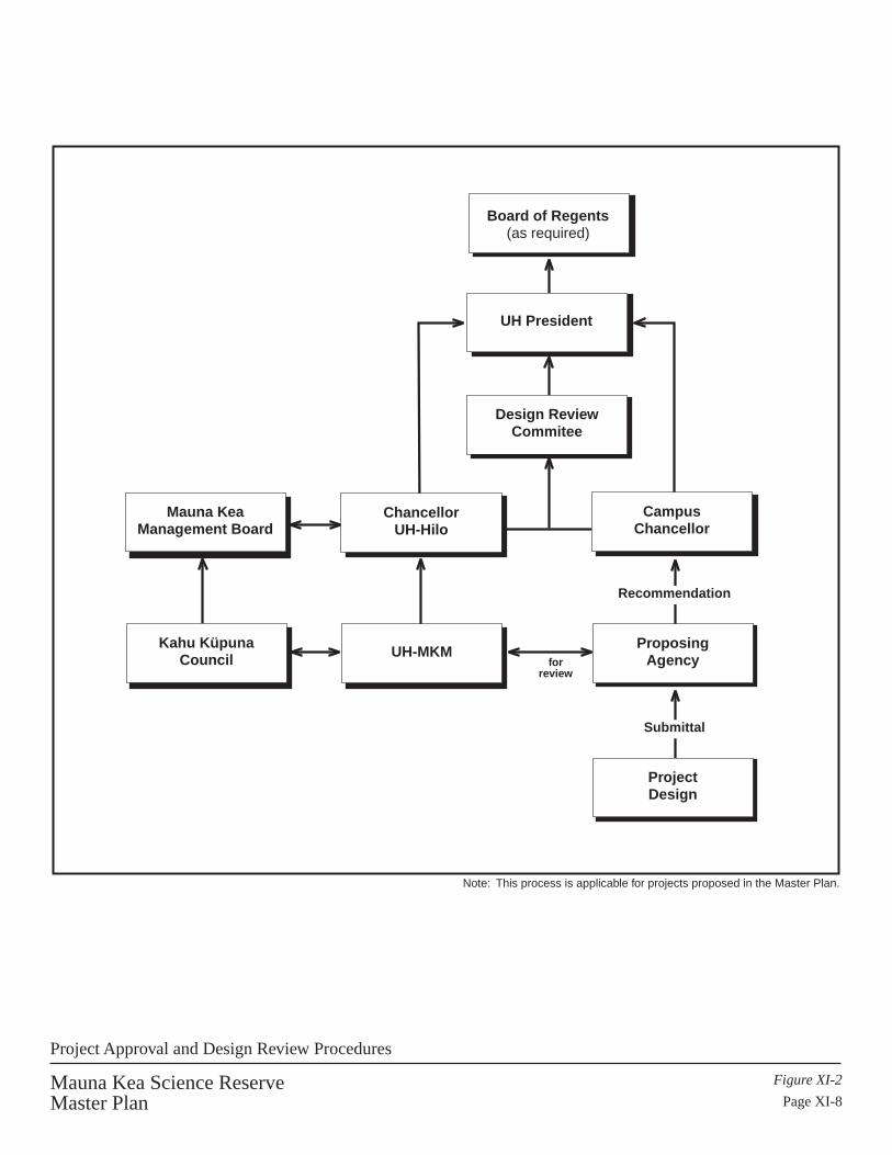
UH-MKM
Mauna KeaManagement Board
ChancellorUH-Hilo
Design ReviewCommitee
ProjectDesign
Submittal
ProposingAgency
Recommendation
CampusChancellor
Board of Regents(as required)
Kahu KüpunaCouncil
Note: This process is applicable for projects proposed in the Master Plan.
Mauna Kea Science ReserveMaster Plan
Figure XI-2
Page XI-8
for review
UH President
Project Approval and Design Review Procedures
- -- ~
a
' . - -
'~ H t I
- ~ - - - -
t I

Mauna Kea Science Reserve Master PlanImplementation Plan Page XI - 9
• Will not negatively impact adjacent facilities or uses;• Promotes resource conservation and sustainability;• Relates harmoniously to the surrounding landscape.• Does not add significantly to negative cumulative impacts.
Plans found to be inconsistent with the Master Plan concepts and objectives shall berejected. Major variations from development standards shall also be rejected.Determinations of consistency shall be at the sole discretion of the University of Hawaiÿi.
Minor and Major Projects: Separate processes are established for the review of “MinorProjects” and “Major Projects.” Minor project review would end with the Office of thePresident. Major projects would be given final approval by the Board of Regents.Examples of minor projects are providing small structures or changing a building’s color.The determination of which process is applied rests with the Office of the President. Thedecision is open to appeal to the President of the University of Hawaiÿi.
Design approval for projects that are described in the Master Plan will follow two reviewpaths. The first path would be through UH MKM, the Mauna Kea Management Boardand the Chancellor of UH Hilo. The second path would flow through the chancellor ofthe campus from which the proposal is initiated. For example, IfA proposals would beprocessed through the Chancellor at UH-Mänoa. Proposals generated out of UH Hilo orthe Community Colleges would be processed through the Chancellor of UH Hilo or theChancellor of Community Colleges. Regardless of the source of the proposal, the oneconstant would be that all proposals would include reviews and comments by the UHMKM, the Mauna Kea Management Board and the Chancellor at UH Hilo.
Review Procedures – Minor Projects: Upon notice of a proposed action, UH MKM willmake an initial determination of the major/minor review process for the President whowill make the final determination. The project would be reviewed at various phases.Phases of the review will generally be as follows:
1. Schematic Submittal: At the initiation of the project, a verbal and graphicsubmission should be made which outlines the action, describes its majorcharacteristics, and briefly assesses its impacts on any existing or approved facility oruse.
2. Design Development Submittal: After approval of the schematic phase, drawingsaddressing schematic design comments should be submitted for design developmentreview. Emphasis should be given to relationships (setbacks, colors, materials, etc.)to adjacent properties and existing buildings.
3. Final Submittal: Should approval be given at the design development phase, finaldrawings and other documents should be submitted for final approval.

Mauna Kea Science Reserve Master PlanImplementation Plan Page XI - 10
The Offices of the Chancellor will complete all phases of the review within 30 days ofthe submission of the review documents.
Review Procedures – Major Projects: UH MKM will make an initial determination onmajor projects for the President who will again make the final determination. Thisdetermination is for processing category; not project approval. Actions determined to bemajor by the President would go through the following process:
1. Pre-design Meeting: This meeting may include the following participants: theapplicant, the project architect/engineer, a representative of the University, arepresentative of IfA, and a representative of the DRC.
The purpose of this meeting is to introduce the applicant and the project architect tothe design and environmental goals of the Mauna Kea Science Reserve, and toprovide a context for further work and reviews. The applicability to the project of theoverall design framework and the specific development standards and guidelinesestablished in this Master Plan will be discussed. In particular, information regardinginfrastructure and elements such as roadways and landscaping will be clarified.Information regarding the character of the Mauna Kea Science Reserve and HalePöhaku will also be provided.
2. Schematic Design: This meeting is to include the following participants: theapplicant, the project architect and other appropriate consultants, representatives ofthe University of Hawaiÿi and the DRC.
At least seven days prior to the meeting the applicant is to submit seven half-sizedschematic plans to the University for distribution. The schematic plans shouldinclude sufficient information to show how the proposed design satisfies theparameters established at the pre-design meeting and the design guidelines of thisMaster Plan.
The review will include the following:
a. Site plan considerations including vehicular and pedestrian circulation, parking,service areas etc. The site plan should show relationships to adjacent facilitiesand resources.
b. Overall building massing considering view planes, heights, setbacks, etc. Allmajor sections and elevations should be indicated.
c. Building characteristics including architectural style, volumetric forms, buildingmaterials, colors, etc. and perspective drawings and/or models are encouraged.Models may be physical or 3D computer files.
d. Landscape plans showing general concepts, plant, rock and ground features.

Mauna Kea Science Reserve Master PlanImplementation Plan Page XI - 11
e. Basic environmental effects (i.e. sunlight and shade, wind surface topography anddrainage), especially on adjacent properties and resources.
f. Energy and other resource conservation methods.
g. Provisions for recycling and use of recycled materials.
Whenever possible, recommendations arising from the review will be forwarded tothe applicant within thirty (30) days of the meeting. Other meetings in the schematicstage may be necessary if the design is not initially approved. The review period maybe extended for up to thirty (30) additional days to review plans for large projects orprojects which require more study. Schematic design submittals will also bereviewed by the Mauna Kea Management Board.
3. Design Development: This meeting is to include the following participants: theapplicant, the project architect, representatives of the University of Hawaiÿi and theDRC.
At least seven days prior to the meeting the applicant is to submit seven half-sizeddesign development plans and outline specifications to the University for distribution.
The information to be provided on the design development plans include thefollowing:
a. Site plan drawings shall at a minimum include the following information: allbuilding locations and sizes, number of stories, setbacks, locations of roads andwalks, location and size of parking areas and service bays. Ground elevationswith existing and finished grades, drainage, earthwork, utility lines, etc. should beindicated. Special attention should be given to relationships to adjacent facilitiesand nearby natural or cultural resources. Energy and resource conservationmethods should be identified.
b. Review of conceptual floor plan drawings at a scale of at least 1/8" = 1.0' for allbuilding types.
c. Review of elevation drawings. Inclusion of perspective drawings and a physicalor computer 3D model is encouraged. Special attention will be given to dome androof colors, forms and materials. Building colors and materials will also beevaluated.
d. Review of sections of buildings and site. Attention will be given to any majorchanges in ground elevations in regard to drainage, views and adjacent facilitiesand natural and cultural resources.
Mauna Kea Science Reserve Master PlanImplementation Plan Page XI - 12
e. Review of landscape drawings. These drawings should show the location, type,size, and quantity of all plant materials, walks, landscape lighting, signs, pavedareas, rock and ground surface materials, etc.
The design development review will be completed within thirty (30) days, and areport forwarded to the applicant containing the recommendations and requirementsarising from the review and meeting. The review period may be extended for up to30 additional days to review plans for large projects or projects which are deemed torequire more study. Design development documents would also be reviewed by UHMKM and the Mauna Kea Management Board.
Approval will depend on the extent to which the proposed design satisfies theobjectives, standards and criteria established in previous reviews, as well as thoseidentified in this Master Plan. Other meetings in the design development stage maybe held if the design is not initially approved. In no case should the applicant proceedwith construction documents prior to design development approval.
4. Construction Documents Review: Construction documents will be checked forcompliance to design review comments. Two half-sized construction drawings andspecifications should be submitted to the University. Approval of the documents or areport listing modifications will be forwarded to the applicant within thirty (30) daysof their receipt. The review period may be extended for up to 30 additional days toreview plans for large projects or projects which are deemed to require more study.Drawings should, if possible, be accompanied by a computer disk containing theoverall site plan and landscape plan.
Approval of construction documents by the Design Review Committee and theUniversity of Hawaiÿi does not constitute authorization to proceed with the project.Compliance with applicable codes, laws, ordinances, and governmental agencyconditions of approval is the responsibility of the applicant.
Construction Review and Approval:
1. Duration of Final Approval: Any approval provided shall be effective for a periodof 12 months and shall be deemed revoked if the approved construction,reconstruction, refinishing, alteration, or other work approved thereby has not begunwithin the 12 month period. The University may authorize an additional 12 monthextension on the approval.
If approval lapses hereunder, the owner or lessee may be required to resubmit thefinal plans and specifications for approval. The DRC and the University of Hawaiÿishall not be bound by any previous decision in reviewing such plans andspecifications, but shall either approve or disapprove the same in writing within thirty(30) days after such resubmission.

Mauna Kea Science Reserve Master PlanImplementation Plan Page XI - 13
2. As-built Plans: Upon completion of construction, a complete set of as-built plansand specifications for infrastructure improvements will be provided to UH MKM.
Temporary Facilities: Temporary facilities are facilities that, when constructed, areplanned for removal within five years of completion of construction. These facilitiesinclude test optics, facilities for short term experiments, constructions support structures,temporary cultural, educational or recreational activity shelters and structures and smalltest facilities.
1. Approval Process: Temporary facilities will go through the same project review andassessment procedures identified in this section for permanent facilities. As with thepermanent facilities there will be a distinction made between Class A and Class Bfacilities paralleling the Class A and B amendment criteria identified in this chapter.Those that may have potentially significant impacts will be processed through themajor projects review channels. Facilities deemed to have minor impact will beprocessed through the minor projects review track. It is anticipated that mosttemporary projects may be processed through the minor projects review process.Appeals may be processed through the Director’s to the Office of the President of theUniversity of Hawaiÿi. Temporary facilities need not go through the formalamendment process which would then require a subsequent amendment to remove thefacility from the Master Plan when the facility or activity is terminated.
2. Pre-application review: When proposals for temporary facilities are received, inaddition to the normal project review criteria they will be evaluated according to thefollowing additional criteria:1. Duration of existence;2. Likelihood of extension requests.
3. Extensions – Single or Multiple: Requests for the extension of a temporary use willbe sent to the Director of the Mauna Kea Management Office. Appeals for thegranting or denial of extensions would be sent to the Office of the President of theUniversity of Hawaiÿi. Reasons for the approval of extensions may include thefollowing:
1. Unusual hardships or delays due to budgets and financing,2. Inadvertent delays in the start or conduct of the,3. Discoveries that suggest additional areas of investigation,4. Mitigation requirements that required additional time.
The Director may approve extensions from one year to two years as appropriate. Amaximum of two extensions may be allowed for a total extension not exceeding threeyears. Uses extending beyond this would require a formal amendment to the plan.
4. Removal After Term: All temporary facilities will be demolished and/or removedafter completion of the use term unless otherwise exempted by the President of the

Mauna Kea Science Reserve Master PlanImplementation Plan Page XI - 14
University of Hawaiÿi. The site will be restored to the pre-existing natural site asmuch as practicable. The Office of Mauna Kea Management will monitorcompliance with this condition. The President will receive a report andrecommendation from the MKM and the Mauna Kea Management Board beforemaking final decisions on any exemptions to this requirement.
Variances:
Variance requests will be approved or rejected by the President of the University ofHawaiÿi. Requests for variances from development standards and guidelines may beapproved if they are minor in nature and otherwise consistent with the overall goals andobjectives of the Master Plan. Variance requests found to be substantially inconsistentwith the provisions of this document will not be approved. Variances will be approvedafter receiving input from the DRC, the Mauna Kea Management Board and UH MKM.
AMENDMENT PROCEDURES
Plan Amendments
The Mauna Kea Master Plan is adopted by the University of Hawaiÿi Board of Regentsand will guide the use and development of the Science Reserve. It is anticipated thatthere would not be many amendments to the plan during its life. Amendments would berequired for large new facilities and major renovations only if they are not anticipated inthe Master Plan. Projects identified in the Master Plan would not require planamendments unless there are significant changes in design or location that have majorimpacts on the plan itself or the environment. It is proposed that plan amendments beseparated into two categories: Class A and Class B amendments.
Class A amendments would be major amendments for proposals that require approval bythe Board of Regents. Examples of these include:
• New projects not identified in the Master Plan with site coverage over 2,000square feet or a building envelop over 24,000 cubic feet (40' x 50' x 12');
• Major expansions of existing facility sites not anticipated in the Master Plan(more than 50% of existing floor area or 2,000 square feet, whichever is greater);
• Improvements identified in the Master Plan which require significant changes insize or location;
• New utility alignments and corridors.
Class B amendments would be administrative. Final approval for Class B amendmentswould rest with the President of the University of Hawaiÿi. Class B amendmentrequirements also apply only to projects that are not anticipated on the Mauna KeaMaster Plan. The following are examples of Class B amendments:

Mauna Kea Science Reserve Master PlanImplementation Plan Page XI - 15
• Significant land altering proposals unanticipated in the Master Plan with a groundcoverage of less than 2,000 square feet and a volume of less than 24,000 cubicfeet;
• Unanticipated additions (less than 50% of existing floor area or 2,000 square feet,whichever is greater);
• Accessory support facilities;• Comfort stations;• Temporary structures;• Roadway and utility improvements within existing alignments and corridors;• Other unanticipated proposals such as significant equipment platforms, parking
areas or cultural facilities such as heiau over 2,000 square feet.
Exempt Activities: Many improvements would not require plan amendments eventhough not explicitly anticipated in the plan. Exempt actions would be reviewed by theUH MKM, Office of the Chancellor. Questions of qualification for exemption would bedecided by the President of the University of Hawaiÿi. Exempt activities include but arenot limited to the following examples:
• Small ahu and shrines used for traditional cultural practices;• Renovations within existing structures;• Repairs to existing facilities;• Exterior renovations which do not significantly change the scale or character of
the structure;• Utility repairs and upgrades within existing lines, conduits and utility corridors;• Routine and emergency roadway repairs, guardrails or vehicle ramps;• Minor drainage improvements;• Addition or deletion of signage;• Installation or removal of walls and fences;• Minor landscaping;• Other minor activities such as the placement of instructional and safety signs and
movement and placement of rock boulder lines.
Rules for amending the Master Plan are guided by the rules of policies of the Board ofRegents. Board of Regents procedures for plan amendments are specified in their rulesentitled “The Facilities Planning Process for Implementation and Management of Long-Range Development Plans, University of Hawaiÿi”. Board of Regents informationrequests include program justification, functional relationships, square footages, designrequirements, alternative sites analyses and special studies, as needed.
All amendments would be processed through the UH MKM and the Chancellor of UHHilo (See Figure XI-3). All amendment proposals would be reviewed for generalconformance with the Mauna Kea Master Plan goals and objectives.

Mauna KeaManagement Board
Proposal
SubmittalKahu Küpuna
Council
Board of Regents
UH President
Design ReviewCommitee
ChancellorUH-Hilo
UH-MKM
Submittal
Mauna Kea Science ReserveMaster Plan
Figure XI-3
Page XI-16
General Master Plan Amendment Procedures for Science Reserve
t I
H
' '
- -- -
H
' , a
I

Mauna Kea Science Reserve Master PlanImplementation Plan Page XI - 17
For Class A amendments, the office would receive and process all applications. UHMKM would review the application, suggest changes or additions and send the proposalwith its review and recommendations to the Office of the Chancellor at UH Hilo. TheOffice of the Chancellor would transmit proposal material to the Mauna KeaManagement Board for their comment. The Board would submit its comments andrecommendations to the Office of the Chancellor. If the proposal is a building or aproject that may have an impact on the physical or aesthetic qualities of the mountain theOffice of the Chancellor may request additional review by a design review committeeattached to the Office of the President. The design committee would review the proposaland submit its comments and recommendations to the Chancellor. The Office of theChancellor at UH Hilo would prepare a report and forward the Management Board’scomments, design review comments and its own recommendations to the President of theUniversity of Hawaiÿi for consideration by the Board of Regents.
Class B amendments would follow the same procedure as Class A amendments exceptthat final decisions would rest with the President of the University of Hawaiÿi.
Classification of a proposal as either Class A, Class B or Exempt does not obviate theneed for any other pertinent federal, state or county requirements set by statutes orordinances. Many plan amendments are likely to require Chapter 343 EnvironmentalAssessment or Environmental Impact Statement documentation. If the UH MKM is notthe proposing agency, it should begin its review of these documents at the pre-consultation stage. Other frequently needed reviews are historic sites review and Section7 endangered species consultation. Proposals that may impact significant historic sites ortraditional cultural properties would require DLNR review and approval even in theScience Reserve. Consultation with SHPO is recommended at an early stage in projectdevelopment.
ADMINISTRATIVE RULES
Administrative Rules should be adopted within one year of the formation of the UHMKM and the appointment of the Mauna Kea Management Board. Rules should beadopted for both the MKM and the Management Board.
AUDITOR’S REPORT RESPONSES
As noted in Section 8 the Legislative Auditor’s Report concluded with a number ofcomments and recommendations. The following section responds to the Auditor’sReport. The bold sentences and phrases are the auditor’s comments andrecommendations.

Mauna Kea Science Reserve Master PlanImplementation Plan Page XI - 18
Management:
• Develop rules and regulations for development and public access in the summitarea and Hale Pöhaku.Rules for the Science Reserve and Hale Pöhaku are to be developed and processed bythe UH MKM. Rules and regulations will be adopted pursuant to Chapter 91.Tentative schedule for rules adoption is June 2002. Public access will not berestricted but it will be managed.
• Hire ranger/guides at Hale Pöhaku who will be there on a daily basis.Rangers will be an integral part of the UH MKM. There will be a minimum of tworangers on the mountain every day. They will operate out of Hale Pöhaku. Theserangers will be trained in cultural and natural resource management.
• Require registration of visitors for education and safety reasons.This is the primary reason for managed access. Visitor registration procedures will bepart of the proposed rules being developed. It is anticipated that registration willoccur at the VIS at Hale Pöhaku and managed by the ranger. Registration willinclude orientation on safety, environmental and cultural aspects of Mauna Kea.
• Develop milestones, specific timeframes & other controls to ensure implementation.The implementation schedule presented in this chapter identifies milestones and timeframes. Other controls and assurances of implementation are identified in Section 10under Management Plan. Incorporating the UH MKM as an integral part of UH Hilomakes the management of Mauna Kea a clear responsibility accepted by theUniversity of Hawaiÿi. It also establishes a sustainable funding platform for the office.
• Develop a forum for continuous community input.The appointment of the proposed Mauna Kea Management Board provides a forumfor continuous community input. Additionally, the creation of a Kahu KüpunaCouncil creates an added dimension and authority to the community’s voice. Finally,as programs are developed it is anticipated that docent programs on many subjectareas will be created providing ongoing partnership with volunteer organizations andcommunity members. Volunteer groups will be encouraged to assist in thestewardship of the mountain during events such as clean-up days or possible futureprograms such as silversword re-vegetation or habitat restoration in the mämane-naioforest around Hale Pöhaku.
• New method for measuring impact.Telescope counting was criticized in the Auditor’s report as an inadequate method formeasuring impact which did not take into account changes in technology.Interferometers were specifically identified as needing special treatment. Theupdated Master Plan measures impact more specifically by observatory type, externalimpact as measured by design guidelines and improvements evaluated by site location

Mauna Kea Science Reserve Master PlanImplementation Plan Page XI - 19
and type. Maximum sizes and color are included in the evaluation criteria. Proposedprojects are grouped into recycled sites, expansions of existing facilities and newlocations. Adoption of this Master Plan and its project review process provides a newand specific methodology for assessing the Master Plan impact of each facility. ThePlan also requires that projects which deviate from the Master Plan’s descriptions orare not described in the Master Plan must under go full environmental review (EIS) asmajor amendments to the Plan.
• Measure impacts individually and cumulatively.Individual and cumulative impacts are addressed in the Master Plan EIS process.State and Federal EIS laws both require analysis of individual and cumulativeimpacts. This is addressed by the formation of UH MKM and the Mauna KeaManagement Board. These two entities will now be a part of every EIS reviewprocess and ensure broad and comprehensive reviews which will include individualand cumulative impacts. In addition, all individual projects must be individually andcumulatively addressed in project specific Environmental Assessments and/orEnvironmental Impact Statements.
• State specific carrying capacity.• The issue of carrying capacity was discussed with the Office of the LegislativeAuditor. It was clarified that the comment was generic and not a specific reference toa methodology or specific study product. It is understood that the technical carryingcapacity of the Science Reserve is huge; limited only by available sites, infrastructure,critical habitat, historic sites and the interference of one facility by another. TheScience Reserve is large and capable of housing many more instruments orobservatories. The concept of social carrying capacity used in recreation andwilderness planning does not result in clear limits to capacity because of differencesin opinion and tolerance. The concern implied behind the comment was addressed bylimiting physical development to an Astronomy Precinct of approximately 525 acresand re-designating the rest of the Science Reserve as a Natural Cultural PreservationArea. Several factors relating to carrying capacity were instrumental in the definingthe boundaries of the precinct. First, all undeveloped summit puÿu were removed asfuture development sites. Additional Wëkiu bug habitat was avoided. Specifically,the precinct was defined on the west by eastern edge of the Puÿu Pöhaku NARboundary. To the north, consideration of the concentrations of archaeological sites atthe outer edge of the summit plateau defined the limit. On the eastern side, viewprotection and the retention of the pristine character of the eastern flank limiteddevelopment to the developed areas of the summit ridge. The southern boundary wasbased on the protection of a westward view corridor from the true summit(Kükahauÿula), and an analysis of views and relationships between Puÿu Poliÿahu,Waiÿau, Kükahauÿula, Lïlïnoe and the adze quarry (Keanakäkoÿi). Attempts weremade to minimize future disturbance of the southern edge with the idea of protectinga relatively intact cultural landscape. These factors relate to the concept of carryingcapacity implied by the Auditor’s report and the companion recommendation toidentify no-build areas.
Mauna Kea Science Reserve Master PlanImplementation Plan Page XI - 20
• Require management plans that have time frames.The management plans described in this Plan include the time frames identified inthis chapter. While some deviations may occur due to unforeseen circumstances, theinclusion of major stakeholders and the community as partners with the University ofHawaiÿi in the decision process ensures its timely implementation.
• Ensure internal deadlines prior to release of land or sub-leases.The Auditor’s report states that sub-leases and other land management issues are notcompleted in a timely manner. This criticism was largely aimed at the Department ofLand and Natural Resources. In its report to the Legislature, the DLNR mentionedthe following:
1. It will work with the UH Institute for Astronomy to ensure the completion of sub-leases prior to the start of construction.
2. Land Division has begun a computerization plan to track and administer permitsand sub-lease issuance in a timely manner.
3. Ongoing discussions with the University regarding lines of authority andmanagement responsibilities on the mountain.
Development of UH MKM will facilitate the performance of these responsibilities.
• Make sure all responsibilities are assigned; either UH or DLNR.It is noted that all responsibilities are currently assigned by legal requirements. Theproblem in the past has not been in the assignment of responsibilities but in theresources and personnel needed to address them adequately. Additionally,overlapping responsibilities, the complexity and generality of rules and policies hasled to a public perception of mismanagement, unfulfilled responsibilities and ignoredpromises. The creation of the UH MKM at UH Hilo addresses this issue by creatinga lead agency based on the Big Island that can receive concerns and make sure theyare addressed or brought to the attention of the responsible agency. UH MKM willfunction as the public point of contact with the University and its responsibilities. Forother responsibilities UH MKM will act as liaison and bridge to the appropriateagency and assist in the follow through of community concerns.
Historic/Cultural Resources:
The Auditor’s report was critical of the neglect of cultural issues and resources. Thecriticism is one of not valuing and protecting both cultural sites as well as traditionalcultural practices. Specifically, the report calls the University to do the following:
• Address cultural and historic issues.Cultural and historic issues have been addressed in a number of ways. First, theplanning process has resulted in new knowledge about the cultural and historicalresources of Mauna Kea. In the development of the updated plan a detailed

Mauna Kea Science Reserve Master PlanImplementation Plan Page XI - 21
archaeological study was conducted by Dr. Patrick McCoy of the State HistoricPreservation Office. His final report is currently being completed. Additionally,ethnographic studies have been conducted by Kepä Maly which include archivalsearches into Hawaiian language documents dating back to the 19th century and oralhistory interviews with cultural practitioners, küpuna and kamaÿaina. Theinformation gathered in the ethnographic studies have been assessed by PHRI, Inc.Input was also received through the Mauna Kea Advisory Committee appointed bythe President of the University of Hawaiÿi. Committee members solicited additionalinput from other community sources. Holly McEldowney is working on a historicpreservation plan for the Science Reserve and the SHPO is considering thedesignation of the summit area as a historic cultural landscape.
The information from the archaeological survey, ethnographic study and thePresident’s Mauna Kea Advisory Committee were incorporated in a GIS database.The components and configuration of the Physical Plan within the Master Planincorporates both physical, spiritual and symbolic cultural issues in a balanced way.The importance of the cultural values in the Science Reserve are emphasized andformalized by the designation of 10,763 acres as a Natural/Cultural PreservationArea. Astronomy development areas were reduced to a 525-acre precinct.
The Cultural Resource Management Plan, siting criteria and design guidelines allconsider potential impacts to cultural and archaeological site and resources. Sitespecific inventory level surveys are requirements prior to facility siting. Culturalsensitivity to view impacts are considered and minimized where practical. Allundeveloped summit puÿu are removed from future development.
A permanent Kahu Küpuna Council is recommended to help guide the University’smanagement of Mauna Kea’s cultural resources and cultural practices. Thecommittee would also assist in the resolution of questions and potential conflicts.
New protocols during visitor registration will improve sensitivity to cultural resourcesand values. Signage plans and the cultural resources management plan are geared tothe protection of these resources by directing visitors to less sensitive areas andeducating them about the value of these resources. Rangers will be especially trainedin this area to educate the public and protect resources.
New protocols for construction are also proposed to protect cultural resources. Thedetails of the protocols will be delineated in the Preservation Plan being prepared bythe State Historic Preservation Office. Some features of this plan will includemonitoring programs and the presence of qualified archaeologists during excavationsand related construction activities that may have the potential to impact culturalproperties.
Mauna Kea Science Reserve Master PlanImplementation Plan Page XI - 22
• Complete the Historic Preservation Plan.A memorandum of agreement was signed between the University of Hawaiÿi and theDLNR for the State Historic Preservation Office to prepare the Historic PreservationPlan at the University’s expense. A detailed outline has been developed to date. Asnoted earlier, a proposal in the Historic Preservation Plan to designate the summitregion as a historic, cultural property is being considered. A full draft of the Planwas completed in March 2000 by the State Historic Preservation Office with adoptionfollowing public review.
Maintenance:
• Periodic inspection and documentation of trash control.This is occurring. In the future, this responsibility will be handled through the UHMKM.
• Remove remnants of old equipment.The two instances that led to this comment have been removed. New subleaseagreements will include this requirement as a routine condition and UH MKM willmonitor compliance.
Physical Planning Guidance:
• Identify areas suitable for astronomical development.Areas suitable for astronomy development have contained in an “AstronomyPrecinct” of approximately 525 acres.
• Identify critical habitats for plants, invertebrates and other endangered species.There is no officially designated endangered species in the Mauna Kea ScienceReserve. The Wëkiu bug (Nysius wëkiucola) is being considered for endangeredstatus but this has not yet occurred. The notion of critical habitat is an unclearparameter in the absence of knowledge about the life cycle of the species, criticalpopulation size or area distribution. However, new biological studies identifiedhabitat areas for ferns, lichen, moths, spiders, and Wëkiu. These areas wereidentified, placed in a GIS database, and mapped. Areas considered sensitive habitatwere avoided as much as possible. The importance of the mämane-naio forest as acritical habitat of the palila has always been considered a given. Development atHale Pöhaku recognizes the importance of this habitat and follows guidelines whichavoid or minimize disturbance to this ecosystem.
• Identify no build zones.The area outside the Astronomy Precinct is a “no build” area. Theoretically, withoutsuch a restriction, development could occur anywhere in the 11,288 acre ScienceReserve. The VLBA is a case in point.
Mauna Kea Science Reserve Master PlanImplementation Plan Page XI - 23
• Include facilities besides telescopes.A recreation support pavilion is identified in the summit area. Other non-telescopefacilities were not included because there were no specific requests from other users.It was decided that facilities would not be proposed unless there were users groupsrequesting them since it was not the intent of the Master Plan to encourageunsupported development in the summit area.
At Hale Pöhaku the Plan proposes sharing some facilities and encouraging the use offormer construction cabins for other non-astronomy purposes. The Subaru Cabins arespecifically targeted for this function. The VIS is also planned for expansion toaccommodate other uses. The stone cabins at Hale Pöhaku might also be renovatedfor other uses.
Statutory Recommendations/Sublease Agreements:
• Incorporate EIS mitigation measures as CDUA conditions.This is a recommendation to the Board of Land and Natural Resources since theBLNR issues conservation district permits. The Department of Land and NaturalResources has stated in its December 1998 response to the State Legislature that itagrees with the purpose of this recommendation and will pursue its implementationmore diligently in the future.
• Relate permit conditions to sub-leases.DLNR and the University of Hawaiÿi will review this recommendation and whereapplicable include permit conditions in the subleases to any future tenants. This willalso be considered in the renewal of existing subleases.
• Adopt rules for Chapter 6E, Historic Preservation Program.Draft rules for Chapter 6E were published and circulated for review in May 1999 andFall 2000. After a period of public review and revision, it is anticipated that theserules will be adopted in late 2000 or early 2001.
All items in the Legislative Auditor’s report have been addressed (see Table XI-1).Several items have already been completed and the remainder is projected forimplementation with the adoption and commencement of this Master Plan Update.

Mauna Kea Science Reserve Master PlanImplementation Plan Page XI - 24
Table XI-1Response to Auditor’s Recommendations
Addressedin MP
ImplementationMilestone
ManagementDevelopment rules and regulations for summit area andHale Pöhaku
ü Draft 6/2001Final 6/2002
Hire ranger/guides at Hale Pöhaku who will be there on adaily basis
ü 7/2000
Require registration of visitors for education and safetyreasons
ü
Develop milestones, specific timeframes & other controlsto ensure implementation
ü 6/2000
Develop a forum for continuous community input ü 6/2000New method for measuring impact ü 11/1999Measure impacts individually and cumulatively ü 8/1999State specific carrying capacity üRequire management plans that have time frames ü 6/2000Make sure all responsibilities are assigned; UH or DLNR ü 6/2000
Historic/Cultural ResourcesAddress cultural and historic issues ü 11/1999Compile the Historic Preservation Plan DLNR 6/2000Adopt rules for Chapter 6E, Historic PreservationProgram
DLNR Draft 9/2000Final 4/2001
MaintenancePeriodic inspection and documentation of trash control ü 4/1999Remove remnants of old equipment ü Completed
Physical Planning GuidelinesIdentify areas suitable for astronomical development ü 6/2000Identify critical habitats for plants, invertebrates andother endangered species
ü6/2000
Identify no build zones ü 6/2000Include facilities besides telescopes ü 6/2000
Statutory Recommendations/Lease AgreementsIncorporate EIS mitigation measures as CDUA conditions DNLR CompletedRelate permit conditions to lease DLNR OngoingEnsure internal deadlines prior to release of land or leases DLNR 2000

MAUNA KEA SCIENCE RESERVE MASTER PLAN
XII. COMMUNITY INPUT: PROCESS, COMMENTS AND RESPONSES

Mauna Kea Science Reserve Master PlanCommunity Input: Process, Comments and Responses Page XII - 1
COMMUNITY INPUT: PROCESS, COMMENTS AND RESPONSES
The community-input process was multi-tiered and very involved. It began with theformation of a Mauna Kea Advisory Committee established by President Mortimer.Twenty-four members were appointed. Nine of these members were part Hawaiian. Thiscommittee met for 15 months (often twice a month), participated in field trips and heardexpert testimony from IfA, advisory committee members and a panel of cultural experts.
The advisory committee held two series of public meetings. The first set of meetingswere a preliminary set of informational hearings in September of 1998. These meetingswere held in Hilo, Waimea and Kona. The committee held another series of publicmeetings at the same communities after a draft 2 of the Plan was developed in May of1999. Input was received at both sets of public meetings.
Input from the committee played a major role in shaping the Master Plan. The committeeapproved draft 2 for circulation and review in the community. The committee laterrecommended the proposed new management structure but voted to withholdrecommending the draft 3A version of the Plan until the management plan was in placeand native Hawaiian cultural issues were addressed further.
A committee recommendation was drafted on June 2, 1999 and reiterated in a final letterto the Board of Regents in August 25, 1999. The final recommendation stated,
“Our committee was charged in June of 1998 to provide needed input to the University ofHawaiÿi regarding the conditions under which future development should occur onMauna Kea on the Island of Hawaiÿi. Our committee has collected important inputregarding Mauna Kea. A considerable portion of this information has been incorporatedinto Draft #3 of the Mauna Kea Science Reserve Master Plan developed by Group 70.
It is our recommendation that any future development on Mauna Kea be coordinatedclosely with the community. This coordination of community input should be via theMauna Kea Advisory Board and the Kahu/Kupuna Advisory Committee in a formal andpermanent manner. Along these lines, we reiterate our recommendation of June 2, 1999that there be no further construction until a plan is approved, the Mauna KeaManagement Authority is funded and the Mauna Kea Advisory Board is established. TheMauna Kea Science Reserve Master Plan might be approved by the Board of Regentsupon further attention to Native Hawaiian concerns.”
Throughout the planning period the project team met with other organizations and gaveindividual presentations as requested. Groups that were contacted included the HawaiianCivic Clubs, DHHL homestead associations in Keaukaha, Waimea and Kona, HawaiÿiCounty Mayor’s office, State and local units of the ILWU and Big Island LaborCoalition, Hawaiÿi Environmental Coalition and business organizations such as theHawaiÿi Economic Development Board and the Kona Kohala Chamber of Commerce.The team also spoke to many individuals.

Mauna Kea Science Reserve Master PlanCommunity Input: Process, Comments and Responses Page XII - 2
As part of the master planning process an ethnographic study was commissioned and an800 + page oral history report compiled representing 25 interviewees.
Additionally, the EIS process provided another avenue of input for public comments.The EIS was completed prior to the finalization of the Master Plan.
Recognizing the complexity and depth of the Master Plan, the need for a vehicle forbroad public dissemination of the Plan was expressed in a summary circular (AppendixO). This 8-page, newsprint, graphic format document highlights the educational,management and physical elements of the Master Plan, and it incorporates communityvoices expressed during the evolution of the Final Plan.
Mauna Kea inspires all who work and live on the mountain, feel its shadow and view itfrom afar. This is true of those who favor development or oppose it.
While a detailed listing of the issues, questions, concerns and comments would be toovoluminous, the following is a summary of major comments and how they wereaddressed in the planning process.
Cultural Sensitivity: Issues of cultural sensitivity were raised repeatedly. The sensitivityof the plan to Hawaiian cultural values was mentioned and questions were raised as towhether community voices would be heard. Also, the initial plans were criticized forshowing the location of burial sites identified from studies conducted by the StateHistoric Preservation Division. Part of this criticism was based on the perception thatnative Hawaiian voices were not part of the advisory or decision making agencies. At thesame time some native Hawaiians mentioned that the voices that were loudest did notnecessarily represent the majority of the community.
The Master Plan responds to these concerns in many ways. First, responding tocomments about the cultural and spiritual importance of the mountain, the Plan reducedthe potential area for astronomy development from the full Science Reserve of 11,288acres to an astronomy precinct of 525 acres. Further, specific siting areas for telescopeswere designated comprising 150 acres of land within the Astronomy Precinct. This is areduction of 10 acres from the areas specified in the 1983 Long Range Development Planfor telescope siting.
The remaining area is proposed as a natural cultural preserve where astronomy facilitieswould not be developed. The auditor’s report had suggested a “no build” line but theinitial view was that this would be excessively restrictive to astronomy. Upon furtherreview and responding to the input on the cultural importance of the summit area, theidea of the precinct was developed. The precinct is essentially the boundaries of a nobuild line for astronomy to contain its impact on the cultural landscape of the summit.The shape of the precinct was specifically tailored to avoid historic sites, preserve viewcorridors related to possible cultural lines of sight and maintain the integrity of thecultural landscape as much as practicable. The southern boundary was moved northward

Mauna Kea Science Reserve Master PlanCommunity Input: Process, Comments and Responses Page XII - 3
to create greater distance from Lake Waiÿau, which is clearly one of the most significantsites in the summit region. The northern boundary was pulled back to avoid the ring ofshrines at the 13,000 foot elevation. The line was adjusted to leave Puÿu Poliÿahu out ofthe precinct. The eastern boundary was pulled back to reduce the potential visual impactfrom the Hilo side of the mountain.
Second, the Master Plan gives greater sensitivity to historic sites, cultural values andNative Hawaiian issues. The designation of the vast majority of the Science Reserve as anatural cultural preserve is a recognition of the cultural resource value of the mountain.All designations of burials were removed from the Plan. Where known, earlierindigenous place names are used instead of English names or Hawaiian names of laterderivation. An example of this is the use of the name Kükahauÿula for the summit cone.Historic trails are identified and marked for preservation. Larger Shrine complexes areidentified for better protection and management. An ethnographic study andarchaeological study were specifically commissioned for the master planning process.Both studies were the most extensive studies of their kind on the mountain to date.
Third, the Plan protects all undeveloped summit puÿu. As mentioned previously,Poliÿahu was deleted out of the astronomy precinct even though it is recognized as anexcellent observatory site and a roadway and test telescopes were previously placed onthe cone. The Plan specifically identifies undeveloped puÿu as features that need specialconsideration. The recognition that these puÿu were seen as the kino, physicalmanifestation, of akua played a role in this special consideration. The potentiallynegative visual impact on the cultural landscape of development on the ridges and puÿuwas also a consideration in this decision.
Finally, to maintain sensitivity to these issues, the master plan proposes a Mauna KeaManagement Board as an integral part of the management of the mountain. Thesecommunity voices will play an important role in keeping a broad managementperspective. Beyond the Board, the Master Plan recommends that a Kahu KüpunaCouncil be established to assist the Office of Mauna Kea Management in addressingthese issues. This is a recognition that Native Hawaiian concerns are of special value andrequire special knowledge and wisdom to address appropriately. This committee will becomposed of experts in Hawaiian culture and practice and will advise the Office indeveloping appropriate protocols and programs for the mountain and its management.Docent programs and training sessions will be developed to improve the culturalmanagement skills of staff and broaden the sensitivity of workers and visitors.
Land Ownership: The question of land ownership was brought up many times indifferent forms. The summit of Mauna Kea is State land controlled by the Department ofLand and Natural Resources and leased to the University of Hawaii. Sometimes thecomments would focus on the ceded lands issue and how this meant that OHA or someother representative organization of kanaka maoli should receive rent for the land andhave decision making authority over the land. Comments were made that Mauna Kea isnot “your” land, it is Hawaiian land, and that ceded land is just a legal euphemism forstolen colonized lands.

Mauna Kea Science Reserve Master PlanCommunity Input: Process, Comments and Responses Page XII - 4
The Master Plan does not respond to comments on sovereignty, ceded land revenues andthe public trust because these issues are larger than the Mauna Kea Science Reserve Planor the University of Hawaiÿi. They are beyond the scope of the Plan. The Plan is basedon the 1968 lease from the Department of Land and Natural Resources (Lease No. S-4191) to the University of Hawaii and the provisions contained in that lease.
Regarding ceded land, current negotiations between OHA and the State of Hawaiÿi willset the tone for the manner and type of compensation. Also, the University, as aneducational institution, is a beneficiary of the trust and is exempt from the payment of the20% revenues to Native Hawaiians. As a co-beneficiary, the University is also arecipient of public trust revenues. Additionally, the position that the land belongs tonative Hawaiians and not the broader public, as represented by the State of Hawaiÿi, isnot addressed in the study because that issue is also beyond the scope of this plan.
Sacredness of the Mountain/Summit: Along with reverence for the beauty andgrandeur of Mauna Kea there is a broad sentiment about the sacredness of Mauna Kea asthe piko (highest point) in the Hawaiian Islands and the Pacific Basin. Also, themountain’s association with Wäkea the sky father and the snow goddess Poliÿahu and herkin add to this belief. The shrines on the summit area enhance the sense of sacredness, asdo the one known and three suspected burial sites on the upper slopes. There has alsobeen oral testimony about burials of important ancestors in the summit area. Others havesaid that the region is wao akua, the realm or wilderness of the gods. Some have statedthat construction on the summit should stop because it is a desecration of the sacredmountain. Some have claimed that development has disturbed the iwi of ancestors. As acomparison it has been questioned whether astronomers would build on the sacred sitesof other people.
These sentiments have been some of the most difficult to resolve. Distinctions betweenthe sacred and the profane are not the same in Hawaiian culture as they are in westernsocieties. Wao aku is not heaven as the literal translation would imply. It did not meanpeople did not do things or build things in the sacred place. If this were so, the existenceof Keanakäkoÿi in the summit region would not make sense. Keanakäkoÿi is the largestknown paleolithic adze quarry in the world. The adze quarry is literally a manufacturingplace for stone implements with shelters, work stations and shrines. What seemsimportant is the protocol, the attitude of respect and appreciation for nature and gods.Worship and daily life were one in the ancient culture. One asked permission of the godsand the aina before one took or used the resource and then thanked the gods for theirforbearance and generosity.
Process is as important as substance in this situation. Each situation must be viewedindividually with the appropriate sensitivity. The Master Plan responds to these concernsby creating a new management office and Kahu Küpuna Council. The Office of MaunaKea Management should develop new protocols that express this attitude. Theseprotocols should be developed with the advice of the Kahu Küpuna Council and includebroad representation from the Native Hawaiian community. These protocols are

Mauna Kea Science Reserve Master PlanCommunity Input: Process, Comments and Responses Page XII - 5
appropriately a part of the management rules and regulations that will be adoptedpursuant to Chapter 91. The rule making process is separate from the Master Planprocess and takes anywhere from one and a half to two years to complete. We alreadyknow that the values of aloha ÿäina, lökahi and malama pono need to be respected.Ahupuaÿa management principles should also be used as guides where they areappropriate. The incorporation of these values into the rules and management structureof the mountain will be the responsibility of the Office of Mauna Kea Management.
Traditional Cultural Practices: Concerns have been expressed in public testimoniesthat traditional cultural practices will be restricted and sites desecrated. Some of this fearand anger stems from an unfortunate incident that occurred because of misdirected policyon the part of a member of the University of Hawaiÿi maintenance staff. A currentcultural practitioner had created new ahu type shrines with special stones, pöhaku, in thesummit region. Maintenance staff removed the rocks. Apologies have been made andthe staff instructed to leave such features alone in the future, but suspicion and hurtfeelings remain. Other comments stem from the implications of the State SupremeCourt’s PASH decision and what this means for cultural resources in the ScienceReserve. A specific example that has been raised is the modern day removal of adzematerial from Keanakäkoÿi to make adzes and other stone tools. Another example is thealternation of shrine sites in renovation and repair efforts as modern practitioners re-usethese sites in revivals of earlier worship activities.
In early discussions there were suggestions that modern cultural practitioners be givendesignated areas to engage in cultural practices. This suggestion was rejected because itwas felt that there was no reason to place such restrictions on cultural practitioners.
The Master Plan does not restrict traditional cultural practices anywhere in the ScienceReserve. The single exception is to activities that may impact known historic sites. Theresponsibility for protection of historic sites rests with the State Historic PreservationOffice and they are statutorily required to protect these sites. These procedures will beincorporated into rules and regulations that will be guided by Dr. Holly McEldowney’sHistoric Preservation Plan which was commissioned for the Master Plan. DLNR doesnot have enforcement personnel on the mountain and will rely on the management staffof the University of Hawaiÿi to assist in this mission. Additionally, staff trainingprograms and docent programs will raise the awareness level of all people who would beinvolved in some aspect of the management of Mauna Kea. Finally, while the commonperception is a fear of restrictions on traditional practices, in reality the Plan represents arestriction on astronomy development.
Historic Sites: Charges have been made that historic sites have been damaged and boneshave been desecrated. Others have stated that only a portion of the summit area has beensurveyed and a complete inventory is needed. The concept of viewing the summit regionas a cultural landscape rather than scattered distributions of individual sites has taken ongreater value. Comments have often noted that landforms are often significant featuresand that the relationships between forms is as important as the features themselves;including areas that are devoid of features.

Mauna Kea Science Reserve Master PlanCommunity Input: Process, Comments and Responses Page XII - 6
One incident of the disturbance of a lithic scatter site near Hale Pöhaku has beendocumented. The State of Hawaii has not been able to verify charges relating to thedesecration of bones because the people making the statement have not disclosed thelocations where the incidents took place. Also, no reports about bones being exposedwere filed during construction of the observatories to verify the charge. Finally, thearchaeological survey conducted by DLNR for the master plan did not identify any burialsites impacted by construction. Without information it has been impossible to verify ordeny the charge. However, these comments have been persistent. The veracity of thiscriticism is difficult to assess since cultural protocols often prohibit knowledgeablepeople from disclosing this information.
The Master Plan response was to commission DLNR to conduct an archaeologicalsurvey, evaluate the cultural significance of the summit area and develop a managementplan for the cultural resources. These studies were commissioned a year and a half ago.The completed inventory is the most extensive study of its kind done to date. Themanagement plan is still in a preliminary draft stage. While a more comprehensiveinventory would be good to have, due to limitations of time and funding the studyfocussed on the areas that have greater potential of being impacted. The university willinstitute a monitoring program for historic sites and encourage future studies in this area.
Based on the study commissioned for the Master Plan, DLNR is considering designatingthe summit region as a traditional cultural property, with appropriate regulatory criteria,which have not yet been developed. The Office of Mauna Kea Management will need toconsider these criteria in developing their rules and regulations. The Master Planrecognized the concept of natural landforms being the kino or physical embodiment ofgods and spirits and the plan protects all undeveloped puÿu. The concept of the culturallandscape is recognized in the designation of the vast majority of the Science Reserve asa natural cultural preserve. The Astronomy Precinct was deliberately framed tomaximize the visual panorama of the cultural landscape.
Environmental: Testimony on environmental mismanagement has covered a broadrange of issues but centered mostly on three areas: the decline of the wëkiu bugpopulation and the destruction of its habitat, the lack of adequate information andmonitoring programs and the lack of carrying capacity studies of the summit. Thedecline of the wëkiu population has been noted in many comments. Some commentsexpress concern about the Palila habitat at the Hale Pöhaku elevation.
Much of the known information about environmental resources is a result of studiescommissioned for master planning efforts in the early 1980s and the current effort.Recent studies commissioned for the Master Plan show a significant decline in thepopulation of the wëkiu bug. While the reason for the decline in population is notknown (several theories have been postulated from lack of snowfall, loss of habitat tonew alien predators) future monitoring programs are expected to provide moreinformation that will address the question and suggest solutions. The habitat of theendemic wëkiu bug is the cinder cones in the summit plateau region. Destruction of
Mauna Kea Science Reserve Master PlanCommunity Input: Process, Comments and Responses Page XII - 7
some prime wëkiu habitat was expected to occur during the development of the ridgesites for observatories.
The Master Plan responds to the issue by minimizing the potential destruction ofadditional sites by protecting undeveloped summit cones (the primary wëkiu bug habitat)from future development. Additionally, within the existing developed summit ridge,construction will be limited to recycling of existing sites, which are already impacted tominimize areas of disturbance. It should be noted that in the most recent study, morewëkiu were found near disturbed sites close to the observatories than in relativelyundisturbed sites along the summit cone.
Carrying capacity is a broad, vaguely defined concept that refers to the capacity of aplace to receive or “carry” an activity or population. This capacity is often defined interms of density related to the supporting infrastructure or resource base. The termoriginates from biological population studies of animal and plant species, whichproliferate beyond the ability of the resource base to support them and the populationcrashes. It is closely related to the notion of sustainable yield. Others have suggestedmeasures such as social carrying capacity but these concepts are vague, culture boundand highly subjective. There is no clear consensus about what social or cultural carryingcapacity should measure and how they should be measured. Without identified criteriaor methodology it was decided that defining social or cultural carrying capacity wouldnot be a fruitful exercise to pursue further. Therefore, a carrying capacity study was notconducted because it was clear that regarding physical carrying capacity, the mountain ishuge, existing infrastructure has available capacity and the site’s physical capacity farexceeded what was proposed for the mountain. The Plan responds to the concern behindthe question by severely limiting telescope development well below physical limitationsand regulating development of facilities.
Visual Impact: Many comments were made about the visual impact of theobservatories. Some said they were ugly like pimples on the mountain. A few thoughtthey were beautiful and inspiring. Others said the scale was inappropriate to the mountainand they alter the natural pristine quality of the landscape with an industrial look. Somesuggested burying sections of the observatories to reduce visual impact.
The Master Plan responds to these issues by recommending color changes, directingmaterial selections, recommending design solutions and other methods to reduce impact.Top scientists and technicians have been contacted and they have indicated a willingnessto address the challenge of reducing the visual impact of observatory facilities. Inaddition, the master plan has set up design criteria and a design review process that willensure designs that minimize visual impact. The criteria and guidelines that have beenrecommended are the most challenging in the world for astronomy facilities.
Commercial Activity: Some have expressed concern about commercialization of themountain. People seem generally opposed to commercial uses of the Science Reserve.Some have stated that astronomy is a commercial activity. Others have said 20% ofrevenues from commercial uses should be given to OHA.

Mauna Kea Science Reserve Master PlanCommunity Input: Process, Comments and Responses Page XII - 8
Other than minor concession operations and the possible periodic rental of cabins at HalePöhaku no commercial operations are proposed in the Master Plan. The University ofHawaiÿi views astronomy as an educational and research activity, not a commercialactivity. Under current DLNR licensing procedures, purely commercial uses will pay20% to OHA.
The Master Plan establishes the Office of Mauna Kea Management to addresscommercial activities and their coordination with the Department of Land and NaturalResources.
Hunting: The Master Plan places no restrictions on hunting. It should be noted thatDLNR continues to retain all jurisdiction over hunting from the forest reserve to thesummit in the lease of the Science Reserve to the University. At an early stage indiscussion there were suggestions of placing a fence around the summit at a certainelevation to reduce the impact of feral ungulates. However, this suggestion was notaccepted as part of the Master Plan.
Positions on Development: Many voices in the public hearings and the oral historyinterviews expressed the sentiment that there should be no more expansion of facilities.A smaller number have supported expansion of quality facilities and the needs ofastronomy. Some have called for the dismantling of what is there. Others have said it isa clean industry providing good jobs. Others have said that while astronomy is gooddevelopment has been unbalanced toward astronomy and other disciplines not supported.
The goal of the Master Plan has been to balance the various interests and uses on themountain. A no-build option would have a severe negative impact on astronomy. Likeany high technology enterprise, astronomy must continually upgrade and innovate inorder to remain competitive. On the other hand, the possibility of development occurringanywhere in Science Reserve (VLBA is an example) was also changed because thatposition unbalances the scale too much in astronomy’s favor to the potential detriment ofother interests such as cultural and environmental resources. The Master Plan responsewas to designate the remainder of the area outside the Astronomy Precinct as a naturaland cultural preserve. During discussions in the Advisory Committee some people feltrecreational snow play and skiing were inappropriate in a sacred area. However, the Planaccommodates recreational uses with a support facility near the “poi bowl” area of thesummit. The Plan hopes to achieve a balance that protects resources and promotesvaluable uses.
Management: Many concerns about management were raised in the various meetings.Issues ranged from poor trash removal to hours of operation of the visitor center; non-management of cultural and environmental resources was raised. Most of the complaintswere about what was not done and the lack of resources provided to achieve themanagement responsibilities. A related issue was a perception of confusing andoverlapping jurisdictions resulting in certain functions being neglected. Inadequatesafety measures and lack of enforcement of CDUA conditions and lack of oversight over

Mauna Kea Science Reserve Master PlanCommunity Input: Process, Comments and Responses Page XII - 9
construction practices and a number of similar issues were raised. Lack of local decisionmaking authority was frequently cited in the early discussions. Some concern was raisedabout the mountain being controlled by foreign, national and international agencies.Criticism was raised that IfA only took care of the interests of the astronomy communityto the detriment of other interests.
The master planning process responded to the suggestion of alternative managementschemes very early in the process. Due to multi-agency responsibilities a third partyalternative that supercedes UH and DLNR was suggested. The independent third partycommission modeled after the Kahoÿolawe Commission was seriously considered andultimately dropped as infeasible by the Advisory Committee because it would takelegislation to authorize, create a whole new bureaucratic organization and require theagreement of the Board of Regents and the Land Board to implement. Also, preliminarydiscussions with the Board of Regents and the Board of Land and Natural Resourcesindicated that neither Board was willing or able to delegate the authority necessary tocreate a new agency with the suggested authority. Other management options that werediscussed included DLNR taking complete responsibility for management but this ideawas dropped when it was pointed out that DLNR’s Statewide responsibility made itunlikely that sufficient resources would be available and dedicated to Mauna Kea. Theidea of the University of Hawaiÿi taking full responsibility was also suggested butobjections related to off island decision-making and lack of accountability to the localcommunity resulted in this option being dropped. There were suggestions of the UHhiring the equivalent of a third party land manager, like a property manager, to managethe land. RCUH and the Nature Conservancy were mentioned as possible managemententities. Questions of accountability were raised and some of the agencies suggestedwere not eager to take on the responsibility. A final option mentioned was to treat themountain like a park. Some even considered moving the mountain into the National ParkService jurisdiction and letting the Service manage the mountain like Volcanoes NationalPark. Committee members cooled to the idea when they considered the loss of localcontrol and the change in the mission of the managing entity.
The Master Plan proposes the creation of the Office of Mauna Kea Management out ofthe Office of the Chancellor of UH Hilo. By placing the Office under the Office of theChancellor it becomes a visible and integral part of the University system and representsa more permanent and direct commitment. The lack of funding commitment tomanagement was addressed by President Mortimer in a letter to the advisory committeewherein the administration stated that $400,000 dollars would be committed toward theestablishment of the Office of Mauna Kea Management upon adoption of the Plan. Theimportance of managing the broad resources of Mauna Kea is now well understood. Thiswas not the case earlier as management was conducted with a more narrow focus. Thisbroadened focus also creates the potential for other revenue sources. The creation of theMauna Kea Management Board also maintains a community voice that will insist onmaintaining the proper funding priorities and commitments and retaining a broad view ofthe mountain’s resources.

Mauna Kea Science Reserve Master PlanCommunity Input: Process, Comments and Responses Page XII - 10
The issue of local authority is addressed by placing the management office in the Officeof the Chancellor of UH Hilo. While policy authority remains with the Board ofRegents, management authority is now delegated to Hilo. Issues and concerns can now beaddressed locally. Community input will have a clear and singular doorway throughwhich its concerns can be addressed rather than the amorphous and remote structure thatis currently in place. The suspicions about foreign control of the mountain will beaddressed when the public realizes that the Office has real authority on the mountain andthe observatories develop more outreach programs into the community.
Lack of Trust: Lack of trust is a special problem closely related to management butdifferent and associated with specific past experiences and history of relationshipbetween the University of Hawaiÿi, DLNR and the public. Many comments expressedskepticism about the commitment of the responsible agencies to the task of managing theresources of Mauna Kea. Both the University of Hawaiÿi and the Department of Landand Natural Resources were faulted. Lack of funding commitment for managementpurposes raised skepticism about the current promises. The issue of local control is alsoconnected with the issue of trust. Reasons cited for this lack of trust included thefollowing:
• Prior advisory committee was never convened.• Previously promised monitoring was not conducted.• Prior ranger positions never funded and the positions were cut during budget
cutbacks.• Trash control measures were not enforced and clean-up efforts were inadequate.
The Master Plan response is the creation of the Mauna Kea Management Board and theestablishment of the Office of Mauna Kea Management on the Big Island. This shouldgo a long way towards restoring trust as there will now be a face and physical presencewith authority to address community concerns. The new agency exists outside IFA andhas a broader mandate. The Management Board will be staffed and the Office will haverangers on the mountain to educate users and manage resources. The visitor centerdirector will coordinate community programs on the mountain while the Hilo office willinterface with the broader community. Additionally, trash clean-up has been greatlyimproved and the old equipment have been removed.
Access: The question of access has been raised many times: in committee, in publicmeetings and in individual presentations to special groups. Concerns included fears ofrestrictions for traditional practices, hunting and recreation.
In a rare unanimous vote the Advisory Committee recommended managed access asopposed to completely unrestricted access or restricted access. Unrestricted access wasrejected because committee members clearly understood the safety issues involved whenuniformed people travel into the high altitude environment. They also understood thepotential damage to cultural and natural resources, especially through the use of allterrain vehicles and recreational activities that take people off the summit road.

Mauna Kea Science Reserve Master PlanCommunity Input: Process, Comments and Responses Page XII - 11
Restricted access was not supported because members viewed the mountain as a resourcefor all the people of Hawaiÿi and there was strong belief that it should remain open to themany interests that exist.
The Plan repeatedly states that access will be managed, not restricted. Managed accessmeans that visitors will need to register at the visitor center, receive an orientation aboutsafety issues and the value of the resources on the mountain, receive information aboutany applicable rules and then be sent on their way. The purpose of the managed accessis to protect resources and enhance public safety. Rules are suggested to prohibit the useof off-road vehicles. Weather conditions, repairs and emergencies will also dictate somelevel of management. Suggestions for nighttime vehicular movement also indicateadditional guidelines.
Hazards: The following concerns about hazards have been expressed:• High altitude can make people sick; they should be informed.• The summit road is steep and unsafe for normal cars; brake failure is common.• Weather changes quickly and can kill.• Hypothermia and snow blindness are real dangers.• Fires around Hale Pöhaku can be hazards to people and natural resources.• Construction at high altitudes has special hazards such as pulmonary edema and lack
of concentration due to low oxygen.
The Master Plan responds to hazards with the registration/orientation program and anemergency response system implemented by rangers. Management of access will alsohelp address these concerns. A single point of management authority will also allow foroversight into construction and operational safety practices in the Science Reserve.
Process: The master planning process was criticized as exclusive, confusing andinsincere. Keeping the Advisory Committee meetings closed generated suspicion andresentment. The multiple drafts have been confusing and there have not been enoughcopies for review. Some have stated that the approval process should stop while thecommunity discussions are taking place; otherwise the effort is not genuine. Thecredibility of the consultants has been questioned. Others have said the results wereforegone conclusions.
The closed meetings of the Advisory Committee was a decision made by the Committeeearly in its proceedings but the purpose was for manageability not exclusivity. Thecomposition of the group is proof that it was not meant to be exclusive. The accessibilityof documents was a problem and draft 3A was placed on the UH web page to increase itsaccessibility. The multiple drafts were the result of trying to keep the public informed ofan evolving document. Normally, these would have been internal drafts not available forpublic review. Although some have viewed the process with suspicion, the efforts tocreate an open process added to the confusion.
Mauna Kea Science Reserve Master PlanCommunity Input: Process, Comments and Responses Page XII - 12
Benefits to the Public: The benefits of the development on the mountain was the subjectof a number of testimonies. People recognize the general economic, scientific andresearch benefits of astronomy. Local residents, including part Hawaiians, increasinglyfill these jobs as the workforce receives training. However, many Native Hawaiianspeakers questioned the value of the development to Native Hawaiians. Some questionedthe quality of jobs given to local people.
The Master Plan creates a physical plan and management structure that seeks to preservea balance that allows astronomy to continue its evolution as a premier ground basedviewing location and its associated economic benefits. At the same time, the Planprotects cultural, environmental and recreational interests. It provides resource protectionand improves safety on the mountain for all users by the placement of rangers on themountain and opening Hale Pöhaku to more users.
Regarding direct benefits to the Native Hawaiian community, the Master Plan does notspecifically address the issue as a separate topic. It is an area of ongoing discussion. Themaster planning process has heightened awareness about the need for more proactiveprograms in this area. Several are now being reviewed and considered. A positive notefrom the public testimony is the number of local people working in good jobs in theastronomy industry. Many young, part Hawaiian residents are part of this growingworkforce. The October 1999 edition of National Geographic highlighted the role oflocal resident Gary Puniwai and his important role as operator (equivalent to ship’scaptain) of the Keck telescopes.
More work beyond the Master Plan needs to be done. This should be one of the majorfocus areas for the Office of Mauna Kea Management, UH Hilo, UH, astronomers andthe Hawaiian community.

MAUNA KEA SCIENCE RESERVE MASTER PLAN
XIII. REFERENCES

Mauna Kea Science Reserve Master PlanReferences Page XIII - 1
REFERENCES
Atta, George. June 2, 1999. Personal Communication with Holly McEldowney andPatrick McCoy.
Auditor, State of Hawaiÿi. February 1998. Audit of the Management of Mauna Kea andthe Mauna Kea Science Reserve (Report No. 98-6).
Brennan, Joseph. 1974. The Parker Ranch of Hawaiÿi: The Saga of a Ranch and aDynasty.
Carlquist, Sherwin. 1980 (2nd Ed.). Hawaiÿi: A Natural History. Honolulu, Hawaiÿi.
Cordy, Ross, Historic Preservation Division, Department of Land and NaturalResources, State of Hawaiÿi. 1994. A Regional Synthesis of Hamakua District, Island ofHawai‘i.
Cordy, Ross, Historic Sites Section, Department of Land and Natural Resources. August,1986. Archaeological Fieldcheck of Several Projects in the Hale Pöhaku Area of MaunaKea.
DLNR and UH IfA. March, 1995. Revised Management Plan for the UH ManagementAreas on Mauna Kea.
DLNR. General Lease No. S-4191.
DLNR Historic Preservation Division. March 2000. Mauna Kea Historic PreservationPlan Management Components. Prepared for the Institute for Astronomy, University ofHawaiÿi. Honolulu, Hawaiÿi.
Group 70 for Research Corporation of the UH. Amended May 1987. Mauna Kea ScienceReserve Complex Development Plan.
Hammatt, Hallet H. and Douglas Borthwick. May 1988. Archaeological Reconnaissanceof Two Proposed Antenna Sites for the National Radio Astronomy Observatory,Maunakea, Hawaiÿi.
Handy, E.S. Craighill and Mary Kawena Pukui. 1972. The Polynesian Family System inKaÿu, Hawaiÿi.
Howarth, Francis, Gregory Brenner, and David J. Preston. May 7, 1999. An ArthropodAssessment within Selected Areas of the Mauna Kea Science Reserve – Final Report.

Mauna Kea Science Reserve Master PlanReferences Page XIII - 2
Juvik, J. O. and S. P. Juvik. 1984. Mauna Kea and the Myth of Multiple Use EndangeredSpecies and Mountain Management in Hawaiÿi, Mountain Research and Development,Vol. 4, No. 3.
Juvik, James O. and interested UH-Hilo faculty. January 14, 1998. Proposal: Institute forTropical Alpine Research and Management, University of Hawai’i Hilo.
Juvik, Sonia P. and James O. Juvik, Editors. 1998 (3rd Edition). Atlas of Hawaiÿi.
Kamakau, Samuel Manaiakalani. 1991. Ka Poÿe Kahiko: The People of Old.
Kanahele, Pualani Kanakaole and Edward L.H. Kanahele. August, 1997. Social ImpactAssessment Saddle Road Realignment and Improvements - Appendix B: IndigenousHawaiian Cultural Values.
Kilmartin, Jerome O. March, 1974. “Na Mea O Mauna Kea (Things About MaunaKea)”, Explorer’s Journal.
Kjargaard, Maile Stemmermann. July, 1985. Avian Survey of the Hale Pöhaku Area.
Langlas, Charles. July 1998 (Revised February, 1999). Archaeological, Historical andTraditional Cultural Property Assessment for the Hawaiÿi Defense Access Road A-AD-6(1) and Saddle Road (SR200) Project.
Malo, David. 1951. Hawaiian Antiquities.
Maly, Kepä. May, 1998. Mauna Kea Kuahiwi Ku Haÿo I Ka Mälie: A Report onArchival and Historical Documentary Research, Ahupua‘a of Humu‘ula, Ka‘ohe,Districts of Hilo and Hämäkua, Island of Hawai‘i. Prepared for Native Lands Institute.Kumu Pono Associates; Hilo, Hawaiÿi.
Maly, Kepä. February, 1999. 1999 Mauna Kea Science Reserve and Hale PöhakuComplex Development Plan Update: Oral History and Consultation Study, and ArchivalLiterature Research. Ahupuaÿa of – Kaÿohe (Hämäkua District) and Humuÿula (HiloDistrict), Island of Hawaiÿi (various TMK). Prepared for Group 70 International. KumuPono Associates; Hilo, Hawaiÿi.
MCM Planning for California Association for Research in Astronomy. March 1998.Project Description and Environmental Review - Temporary Optical Test Sites for theW.M. Keck Observatory Twin Keck Telescope Interferometer.
MCM Planning for GTE Hawaiian Telephone Company and University of Hawaiÿi,Institute for Astronomy. September 1995. Project Description and EnvironmentalReview - GTE Hawaiian Telephone Company Fiber Optic Cable Project Pohakuloa toHale Pöhaku Link.

Mauna Kea Science Reserve Master PlanReferences Page XIII - 3
MCM Planning for National Astronomical Observatory JNLT Project Office. January1991. Project Description Japan National Large Telescope (JNLT).
MCM Planning for Smithsonian Astrophysical Observatory. January 1994. ProjectDescription and Environmental Review - Smithsonian Astrophysical ObservatorySubmillimeter Array Telescope.
MCM Planning for University of Hawaiÿi, Institute for Astronomy. October 1985.Amendment to the Mauna Kea Science Reserve Complex Development Plan, FinalSupplemental Environmental Impact Statement for Construction Camp Housing, HalePohaku.
MCM Planning for University of Hawaiÿi, Institute for Astronomy. September 1988.Amendment to the Mauna Kea Science Reserve Complex Development Plan, FinalSupplemental Environmental Impact Statement VBLA Antenna Facility.
McCoy, Patrick C., Mountain Archaeology Research Corporation for UH ManoaFacilities Planning and Management Office. 1991 (Field Date: September, 1987). Surveyand Test Excavations of the Puÿu Kalepeamoa Site, Mauna Kea, Hawaiÿi.
McCoy, Patrick, Bishop Museum. Mauna Kea Summit Region Survey: A Summary ofthe 1984 Fieldwork.
McCoy, Patrick C. February, 1999. Mauna Kea Science Reserve Archaeological SiteInventory: Formal, Functional, and Spatial Attributes.
McLaren, Robert. July 23, 1991. Letter to Office of Environmental Quality Control.Project Description for a Proposed Second Telescope (Keck II) on the W.M. KeckObservatory Site at Mauna Kea, Hamakua, Hawaiÿi (Tax Map Key 4-4-15:09).
Mortimer, Kenneth. May 8, 1998. Letter of invitation to Mauna Kea AdvisoryCommittee members.
National Aeronautics and Space Administration. June, 1998. Temporary Optical TestSites for the W. M. Keck Obvservatory Twin Keck Telescope Interferometer – DraftEnvironmental Assessment.
Palila Recovery Team. August, 1977. Palila Recovery Plan.
Parker, Barry. 1994. Stairway to the Stars: The Story of the World’s LargestObservatory.
Paul H. Rosendahl, PhD, Inc. February 1997. Archaeological, Historical andTraditional Cultural Assessment for the Hawaiÿi Defense Access Road A-AD-6(1) andSaddle Road (SR200) Project.

Mauna Kea Science Reserve Master PlanReferences Page XIII - 4
Pukui, Mary Kawena. 1983. ÿÖlelo Noÿeau: Hawaiian Proverbs and Poetical Sayings.Bernice Pauahi Bishop Museum Special Publication 71. Honolulu.
Pukui, Mary Kawena and Samuel H. Elbert. 1986. Hawaiian Dictionary.
Robins, Jennifer J. and Hallet H. Hammatt for MCM Planning. September 1990.Archaeological Reconnaissance for Summit and Mid-Level Facilities for the ProposedJapanese National Large Telescope, Maunakea, Hawaiÿi.
SMS Research. July, I999. Economic Impact of Mauna Kea Observatories, HawaiÿiCounty, State of Hawaiÿi.
Sierra Club, Hawaiÿi Chapter. February, 1998. The Legislative Auditor’s Key Findings:Audit of the Management of Mauna Kea and the Mauna Kea Science Reserve.
Stearns, Harold T. 1966. Geology of the State of Hawaiÿi. Palo Alto, California.
RM Towill Corporation. August 1997. Aerial Topographic Mapping – Portion of theMauna Kea Science Reserve.
Townscape, Inc. for UH Institute for Astronomy. July 1992. Project Description Gemini8-Meter Telescopes Project.
United States Department of Transportation, Federal Highway Administration, CentralFederal Lands Highway Division. 9 October 1997. Draft Environmental ImpactStatement Saddle Road (State Route 200) Mamalahoa Highway (State Route 190) toMilepost 6.
University of Hawai‘i Institute for Astronomy. September, 1981. Program Summary andResearch Development Plan for the Mauna Kea Science Reserve and Related Facilities.
Wolfe, Edward W., William S. Wise, and G.Brent Dalrymple. 1997. The Geology andPetrology of Mauna Kea Volcano, Hawaiÿi – A Study of Postshield Volcanism (USGSProfessional Paper 1557).