Embed Size (px)
Citation preview
HAL Id: halshs-00699201https://halshs.archives-ouvertes.fr/halshs-00699201
Submitted on 20 May 2012
HAL is a multi-disciplinary open accessarchive for the deposit and dissemination of sci-entific research documents, whether they are pub-lished or not. The documents may come fromteaching and research institutions in France orabroad, or from public or private research centers.
L’archive ouverte pluridisciplinaire HAL, estdestinée au dépôt et à la diffusion de documentsscientifiques de niveau recherche, publiés ou non,émanant des établissements d’enseignement et derecherche français ou étrangers, des laboratoirespublics ou privés.
Material flows and local economic structure: port-regionlinkages in Europe, Japan, and the United States
César Ducruet, Hidekazu Itoh, Olivier Joly
To cite this version:César Ducruet, Hidekazu Itoh, Olivier Joly. Material flows and local economic structure: port-regionlinkages in Europe, Japan, and the United States. World Conference on Transport Research (WCTR)SIG-2, May 2012, Antwerp, Belgium. �halshs-00699201�
2012 World Conference on Transport Research (WCTR) SIG-2, Antwerp, Belgium, May 21-22
1
Material flows and local economic structure: port-region linkages
in Europe, Japan, and the United States
César DUCRUET, CNRS & UMR 8504 Géographie-Cités, Paris, France1 [email protected]
Hidekazu ITOH, Kwansei Gakuin University, Japan
Olivier JOLY, University of Le Havre & UMR 6063 IDEES, France
Abstract
The main goal of this paper is to identify mutual influences between the specialization of traffics
passing through seaports and the socio-economic characteristics of their surrounding regions. While
the contemporary era is marked by the fading spatial fix of value chains as notably seen in the
dereliction of port's local linkages, a systematic and comparative empirical analysis remains lacking.
One main reason is the absence of internationally harmonized data on the precise spatial distribution
of port-related hinterland flows as well as inadequacies between the volume and the value of freight.
This research proposes to overcome such difficulties based on a common set of 21 traffic and socio-
economic indicators covering 189 port regions in Europe, Japan, and the United States. Main results
underline invariants as well as local specificities in the functional and spatial affinity between certain
traffics and certain types of regions. While large urban and financial centres tend to polarize most
valued, diversified, and weighty traffics, rural regions generally concentrate agricultural goods and
minerals, and industrial regions concentrate combustibles and metals. Beyond the simple reflection of
local demand, such results confirm the path-dependency of the association between material flows and
regional economic development. A typology of port regions is proposed in order to map the
distribution of port regions and to zoom on specific local conditions.
Keywords: freight flows; port traffic; regional development; typology; value chain
1 Author for correspondence
2012 World Conference on Transport Research (WCTR) SIG-2, Antwerp, Belgium, May 21-22
2
Material flows and local economic structure: port-region linkages
in Europe, Japan, and the United States
1. Introduction
Contemporary transport systems are marked by a dematerialization of the economy and rising
average transport distances thereby making it increasingly difficult for decision-makers and
scholars to map and explain the distribution of firms and flows in relation to their spatial
environments (Leslie and Reimer, 1999; Hesse and Rodrigue, 2004). Continuous progress in
the physical and organisational connectivity of transport systems as well as reduced trade
barriers and logistics costs fostered the spatial volatility of flows, resulting in both
concentration and diffusion of markets and flows across regions and nations (Fujita et al.,
1999; Hesse, 2010). As noted by Janelle and Beuthe (1997), the absence of disaggregated data
on detailed flows has often been a major obstacle to the analysis of their spatial determinants.
Conversely, most research on transportation networks focuses dominantly on freight
movements, capacity and connectivity problems in abstract spaces (e.g. graph theory,
complex networks, routing and modelling), and carriers' strategies, with minor attention paid
to the (changing) socio-economic characteristics of localities (Ducruet and Lugo, 2012). Such
state of affairs also relates with the persistent divide between qualitative and quantitative
approaches within transport geography as well as the difficulty identify underlying causal
structures (Goetz et al., 2009).
Recent efforts have, however, expanded the understanding of the spatial fix of flows as well
as the role of local economies in shaping such flows. It was found, for instance, significant
correlation between the volume of air flows and the demographic and economic attributes of
airport cities in various contexts (Neal, 2011; Dobruszkes et al., 2011; Wang et al., 2011) as
well as strong interdependences between the pattern of communication flows and the well-
being of localities (Eagle et al., 2010). Similar empirical research on maritime flows remains
far less developed due to the drastic lack of data on land-based, hinterland freight flows that
would enable the delineation of regions containing most port users (Darnton, 1963; McCalla
et al., 2004; Guerrero, 2010). Assembling and analyzing port traffic and socio-economic data
on port regions on the level of three large economic areas (namely Europe, Japan, and the
United States) is proposed in this paper as a means to complement such statistical lacks and
2012 World Conference on Transport Research (WCTR) SIG-2, Antwerp, Belgium, May 21-22
3
methodological difficulties. Technological, managerial changes in shipping and ports as well
as the reorganization of hinterlands may not have fully eroded the spatial fix of freight flows,
notably in relation with the adjacent territory or port region. Revealing such linkages might
prove useful for the explanation of traffic distribution across space. The extent to which the
structure of freight flows reflects - at least partly - the nature of adjacent economies also raises
important methodological issues of data and geographic relevance, which will be explored
further in the following sections.
The remainder of this paper is as follows. Section 2 offers a discussion on the nature of port
traffic, with regard to specific commodities, locations, and the problem of transit flows when
trying to assign such traffic to particular places. Section 3 introduces the data and
methodology used to compare the mutual specialization of port traffic and local economies in
Europe, Japan, and North America. Section 4 describes the main trends obtained from a
Principal Components Analysis (PCA) and hierarchical classification of port regions. Finally,
Section 5 discusses the implications of the results for port policy and regional planning as
well as prospects for further research in the field.
2. Background and issues in port-region linkages
The port region remains a rather fuzzy concept broadly defined as the "immediate hinterland"
of the port where most of its clients and port-related activities are located (Vleugels, 1969;
Ducruet, 2009). Although ports are traditionally seen as strategic gateways conferring distinct
characters to their territories compared with those of central places (Bird, 1983), more recent
evidences depict a dereliction of ports' local linkages (Hoare, 1986; Todd, 1993; Campbell,
1993; Vallega, 1996; Musso et al., 2000). Many large ports, however, have maintained their
activities through rapid and profound transformations (Lee and Ducruet, 2009; Wang and
Cheng, 2010; Hall and Jacobs, 2012). While ports have been largely left aside by regional
development literature (Hall, 2002), the local economy has been ignored in studies of port
selection factors (Ng, 2009) and of the added value of port traffics (Charlier, 1994;
Haezendonck, 2001). Discussions on port-related local economic growth provide either
general views and models (Stern and Hayuth, 1984; Fujita and Mori, 1996; Haddad et al.,
2005) or in-depth case studies lacking comparability such as those about port impacts (Hall,
2004a). Most of the time, research is unidirectional by looking at how port and maritime
2012 World Conference on Transport Research (WCTR) SIG-2, Antwerp, Belgium, May 21-22
4
activities influence and impact local economic development while it ignores how the latter
influences and impacts the first.
Although it has always been difficult to measure the benefits of port activities to local
economies (Bird, 1971) especially in a comparative perspective, some recent studies have
provided a number of empirical results supporting the idea of lowering but maintained port-
region linkages. Both quantitative (De Langen, 2007) and qualitative (McCalla et al., 2001)
approaches have revealed a lack of linkages between port activities and their adjacent
economies in the United States and Canada. Port regions also appeared poorer than other
regions in Europe (Lever, 1995) and the United States (Grobar, 2008; Hall, 2009) in terms of
regional GDP per capita and average wage levels. Another set of studies pointed, however, at
noticeable interdependencies between local economies and traffic dynamics. The size and
diversity of urban economies adjacent to ports influences to some degree the size and
diversity of port traffics in the United States (Carter, 1962) and in Europe (Ducruet et al.,
2010), while smaller ports are often more specialized and bound to local industries (Kuby and
Reid, 1992).
One very important aspect of port-region linkages is the influence of the local setting or
context. For instance, the correlation between total port throughput and the demographic
weight of port cities has dramatically lowered on a global level since the 1990s but it has
maintained or even increased in specific regions such as Oceania and North America (Ducruet
and Lee, 2006), due to the diversity of urban-port trajectories, port systems configurations,
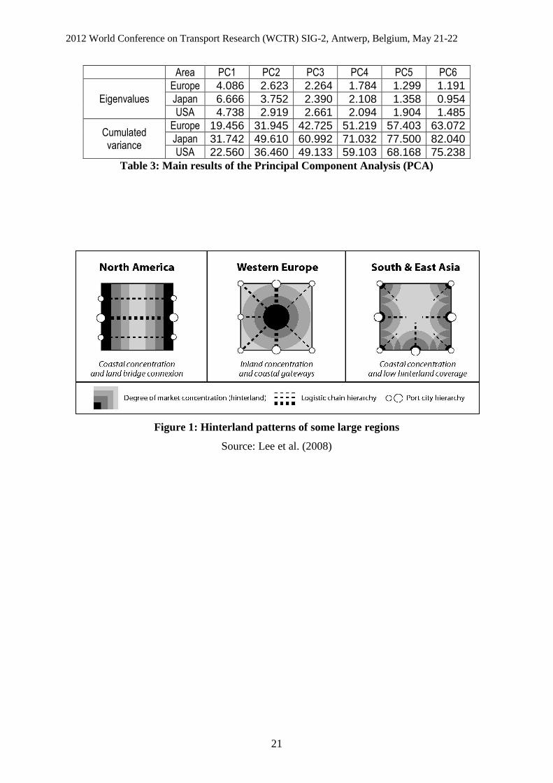
and hinterland spatial patterns (Lee et al., 2008; Rodrigue and Notteboom, 2010). As seen in
Figure 1, different geographical areas exhibit contrasted hinterland spatial patterns, notably
due to the uneven balance between coastal and inland locations in terms of economic
concentrations and transport network connectivity. Europe is more characterized by an inland
concentration of core economic regions as opposed to Asia and North America, although the
latter has also developed continental connections through intermodal transport. One direct
implication of such configurations is the varied importance of transit flows at seaports and
hence, a different meaning of port-region linkages depending on the local context. In China,
gross regional product, amount of Foreign Direct Investment, and industrial productivity had
a positive influence on port traffic growth during the 1995-2007 period (Cheung and Yip,
2011). Across OECD countries and during the same period, regional specialization in the
industrial and tertiary sector had a negative and positive influence respectively on the volume
2012 World Conference on Transport Research (WCTR) SIG-2, Antwerp, Belgium, May 21-22
5
and growth of container port throughputs (Ducruet, 2009). The weak linear correlation
between port traffic volume and the number of firms in port-related sectors has been
confirmed globally (Jacobs et al., 2011) but without contradicting the fact that certain
specialized gateways keep concentrating both tertiary activities and traffics, such as
Rotterdam and Houston (Jacobs et al., 2010).
While most existing studies neglect the diversity of port traffics, another central argument of
this research is that different cargo types will have different affinities with the outlying region
where port traffic takes place (Haefner et al., 1980; Marti, 1985), as seen in the example of
port-industry complexes processing imported raw materials for local transformation, such as
petrochemicals (Rodrigue et al., 2009; Dunford and Yeung, 2009), and in the case of
automobile imports (Hall, 2004b). Indeed, there are wide differences among commodities
passing through seaports in terms of travelled distance and spatial friction as demonstrated by
Debrie and Guerrero (2008) on the French case. One major difficulty is that one same port
may handle a combined set of commodities serving multiple industries inside and outside the
port region. However, such functional and regional differences that are known in practice
were not sufficiently tested empirically based on comparable data and rigorous statistical
methods.
[Insert Figure 1 about here]
3. Data and methodology
3.1 The contours of port regions
One first step was to select economically and spatially relevant local units that would be
comparable across Europe, Japan and the United States. A trade-off between their number and
size resulted in a selection of 115 NUTS-2 regions (Europe, 16 countries), 39 prefectures
(Japan), and 35 States (United States) recording port traffic in the year 2008 and for which
comparable socio-economic data was available. We are aware of the limits of such arbitrary
definitions, which do not always match the true extent of port hinterlands and/or port regions.
The work of Patton (1958) on general cargo hinterlands in the United States clearly recalled
the difficulty delineating such regions and the fact that large ports handle large volumes
destined to / originating from distant areas, thus with no relationship with local industries, and
2012 World Conference on Transport Research (WCTR) SIG-2, Antwerp, Belgium, May 21-22
6
depending on the directionality (i.e. imports vs. exports) as well as intermodal arrangements
(i.e. rail). For instance, it was estimated that 70% of Marseilles' port traffic in 1900 was
destined to local industries (Garnier and Zimmermann, 2004), while more recently, 75% of
New York's port traffic was generated and consumed within a 300 mile radius from the port
(Rodrigue, 2003). The urban areas of Bordeaux (France) and Busan (South Korea) accounted
for only 15% and 10% of respective port traffics in recent years (source: port authorities).
Customs data notably allows calculating the share of the adjacent region in total port traffic
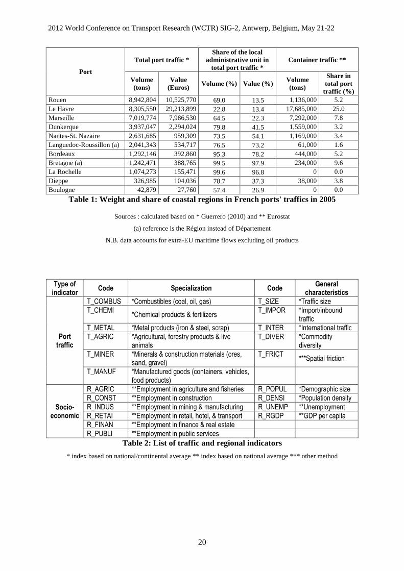
(Table 1): in 2005, French coastal regions (départements) surrounding ports were responsible
for 63% and 18% of French total traffic volume and value respectively (Ducruet, 2011). Such
imbalance between volume and value directly translates the polarization of most valuable
flows by the Paris capital region and other large inland cities. Larger ports tend to handle
higher transit traffics than smaller ports due to the wider spatial extent of their hinterlands,
especially for Le Havre, Paris' main gateway. Traffic is thus inflated by transit flows either
landward (i.e. road, rail, river, pipeline, air-sea) or seaward (i.e. coastal and short-sea
shipping, transhipment, and feedering). The fact that about 40% of French exports pass
through Antwerp and other Benelux ports is a good example of such detours (Gouvernal et al.,
2010). For Le Havre, about one-third of its container traffics relate with the Greater Paris
region (source: port authority). The share of transit flows varies from one port to another
depending on their specialisation in hinterland and/or hub functions. Hinterland ports may
also be maritime hubs, such as Rotterdam (30% transhipment), while others stand as "pure
transhipment hubs" due to the absence of a local cargo base, such as Gioia Tauro in Calabria.
Yet, transit flows are not entirely disconnected from the local economy since they create the
need for additional activities and infrastructures (e.g. warehousing, packaging), but not every
large port has been able to create such value-added. Even a large coastal metropolis may
prefer distant port terminals than its own due to problems of congestion and negative
environmental impacts locally.
[Insert Table 1 about here]
The choice of administrative regions was motivated by the availability of socio-economic data
and by the fact that those regions remain large enough to contain a majority of port-related
activities composing the so-called port cluster (De Langen, 2004). While in some cases the
regional unit is too small (e.g. the Lander of Hamburg) or too large (e.g. California including
Los Angeles, Oakland, and other ports) in comparison with hinterlands, it still has relevance
2012 World Conference on Transport Research (WCTR) SIG-2, Antwerp, Belgium, May 21-22
7
in terms of the location of activities directly related with the port. Large ports located within
such urban areas will thus be amputated in terms of hinterland coverage. This is particularly
true for containers due to the inland shift of many logistics and distribution activities during
the current "port regionalization phase" (Notteboom and Rodrigue, 2005). Among European
port cities for instance, it is often the case that a large proportion of transport activities locate
in suburban areas (Ducruet and Lee, 2007). Nevertheless, administrative regions remain
highly relevant to test the influence of large cities on traffic flows, because port-region
linkages are not only about physical transfers but also refer to immaterial interdependencies,
such as within the tertiary sector, which locate in or close to the Central Business District
(CBD) near the port.
3.2 The choice of port traffics
The nature and level of economic specialization of such regions was measured on the level of
six employment sectors based on various data sources (see Table 2)2. In addition to these core
variables were added regional GDP, unemployment, population size and population density as
proxies for market size and economic wealth. Each regional indicator was calculated as a
location quotient based on the national average (e.g. percentage of primary sector
employment in total employment of region i divided by percentage of primary sector
employment in total employment of the country), except for demographic size and population
density (i.e. score of region i divided by mean score of all regions). Mixing regional indicators
and port traffic indicators, of course, has the "risk of attributing to port-related differences
what are in fact differences in regional economic structure" (Hall, 2002).
Traffic data of individual ports located within the same administrative region was summed by
main category in order to have the same number than for employment variables. Original
sources were in fact dissimilar by their number of detailed traffic categories and their
classification methods3. From the 18 categories provided by Eurostat, containers were counted
as manufactured goods although their detailed content is unknown and may include other
commodities such as neo-bulks, while some other traffic categories are not fully explained:
2 The principal data sources are Eurostat for Europe, the Annual Report on Prefectural Accounts (Cabinet Office of the Government), the Labor Force Survey, Employment Structure Basic Survey, and National Population Census (Statistics Bureau, Ministry of Internal Affairs and Communications) for Japan, the Bureau of Statistics and the OECD Territorial Database for the United States. 3 Data sources used to measure port traffics are Eurostat for Europe, the Ministry of Land, Infrastructure, Transport and Tourism (MLIT) for Japan, and the Army Corps of Engineers for the United States.
2012 World Conference on Transport Research (WCTR) SIG-2, Antwerp, Belgium, May 21-22
8
other dry bulk, other liquid bulk, and other general cargo. In comparison, the 81 and 146
commodities for Japan and the United States respectively were more easily classified into six
common categories. While each traffic category corresponds to specific products, the precise
link with the aforementioned economic sectors may not be obvious, due to the impossibility
distinguishing imports from exports for each commodity. For instance, manufactured goods
that are generally containerized have links with multiple sectors depending on the context,
such as manufacturing (e.g. export), retail (consumption), and transport/logistics (e.g.
warehousing, distribution) (Van der Lugt and De Langen, 2005). The same type of raw
materials can be handled within very distinct local economies depending on if it is exported
(e.g. cereals exported from an agricultural region) or imported (e.g. cereals imported from a
manufacturing region). In addition, some ports have widened their commodity mix through
successive (and often path-dependent) diversification phases. Many modern container ports
are or have been heavy industrial complexes, as seen in South Europe for instance with the
close overlap between main container hubs and former petrochemical and steelwork sites such
as Sines, Huelva, Cagliari, Gioia Tauro, and Taranto. Each of the six commodity categories
was transformed into a location quotient as follows: percentage of combustibles traffic in total
traffic of region i divided by percentage of combustibles traffic in total traffic of the
country/continent.
A few other traffic variables were calculated to complement the analysis of specialization,
such as traffic size, international traffic (i.e. extra-EU27 for Europe), inbound traffic, level of
commodity diversity, and level of spatial friction. International and inbound traffic provide
information on the extent of port activities and their directionality, while traffic size expresses
the overall performance of the port region in accumulating physical flows. International and
inbound traffics were changed to indices based on the same method than for commodity
categories (i.e. percentage of international traffic in total port traffic of region i divided by
percentage of international traffic in total port traffic of the country/continent). Traffic size is
simply a ratio between the total port traffic of each region and the average traffic of all
regions. The level of commodity variety was proposed by Ducruet et al. (2010) in order to
reflect the capacity of a given port (or region) to handle multiple flows. It is calculated for
each port region as the inverse of the sum of absolute differences in commodity shares at
country/continent level. Higher values point at more diversified ports and lower values
underline strongly specialized port regions. The level of spatial friction was derived from the
work of Debrie and Guerrero (2008) on French port hinterlands. Their analysis applied a
2012 World Conference on Transport Research (WCTR) SIG-2, Antwerp, Belgium, May 21-22
9
spatial interaction model on customs data on the amount of transported freight by commodity
types to/from seaports within the country in order to estimate the role of distance on the
volume of port-related flows. They particularly demonstrated that in general, manufactured
goods travel longer distances than liquid and dry bulks. Each of the six traffic categories was
weighted according to their results by commodity-specific parameters4. This indicator
particularly highlights which commodities are more likely to remain produced, consumed,
and/or processed within the port region (captive hinterland) as opposed to more mobile
commodities reaching farther markets (contestable hinterlands). The traffic of each port
region was then weighted by calculating the share of distance-constrained traffic in total port
traffic (spatial friction index).
[Insert Table 2 about here]
4. Traffic specialisation and regional specialisation
4.1 Main trends
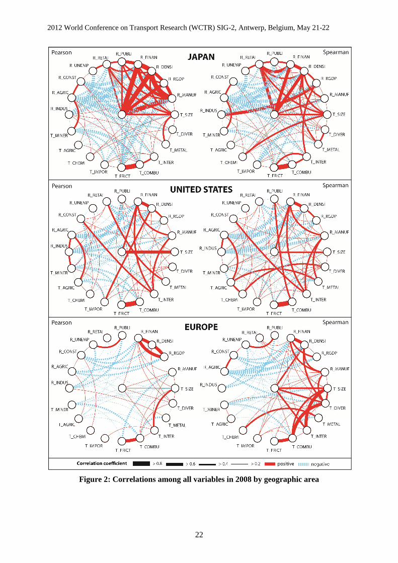
The comparison of correlation coefficients among all variables at each area allows a first
understanding of the main trends affecting port-region linkages (Figure 2). Pearson and
Spearman correlations are compared given the different statistical distribution of variables.
The main trend for Japan is a coincidence between traffic volume, manufactured goods, and a
profile of large, densely populated, richer, and tertiary regions. It underlines the closeness
between urban hierarchy and port hierarchy for the most valued goods. Other traffics have
limited correlation with regional indicators, except for the slightly significant ones between
the agricultural sector and minerals traffic. Most other significant correlations occur either
among traffic variables or socio-economic variables, such as metals and traffic volume,
combustibles and international traffic. Spearman correlations provide a similar picture, with
the exception of metals traffic with population density, and international traffic with the
industrial sector and regional GDP. For the United States and Europe, correlations remain
rather moderate compared with Japan, thereby suggesting a lower statistical significance of
port-region linkages in those areas. The highest positive correlation for the United States
occurs between traffic volume and demographic size, followed by manufactured goods traffic
4 The weighting value for each commodity type corresponds to the share of variance (%) explained by distance and has been measured as follows: 30.1% for manufactured goods, 53.7% for chemicals, 57.1% for minerals, 67.9% for metals, 75% for agricultural goods, and 92% for combustibles.
2012 World Conference on Transport Research (WCTR) SIG-2, Antwerp, Belgium, May 21-22
10
and the financial sector, metals traffic and the retail sector, agricultural goods traffics and the
agricultural sector, international traffic and the construction and financial sectors. Moreover,
Spearman correlations show some strong relationships between public services and
combustibles, chemicals and diversity, and agricultural and metal products. Despite some
differences, such trends are comparable with Japan due to the proximity between large traffics
of higher valued goods, the tertiary (finance and real estate) sector, and population. Japan and
the United States have indeed in common to concentrate container traffics at major urban
centres that also concentrate higher-order economic functions. In the European case, Pearson
correlations are rather insignificant and cannot account for tangible port-region linkages as in
the previous cases. This is partly solved by looking at Spearman correlations based on ranks
rather than initial values. Similar trends thus emerge, such as the closeness between
manufactured goods traffic, the financial sector and population density, while demographic
size is positively and significantly correlated with traffic volume, traffic diversity, and
international traffic, but also chemicals and metals. It thus confirms that among the three areas
considered, the nature of port-region linkages remains similar as most voluminous and valued
goods concentrate at tertiary and populated regions. Although the statistical significance
differs greatly, the nature of port-region linkages is comparable thus supporting the idea of
invariants in the geography and locational factors of port traffics.
[Insert Figure 2 about here]
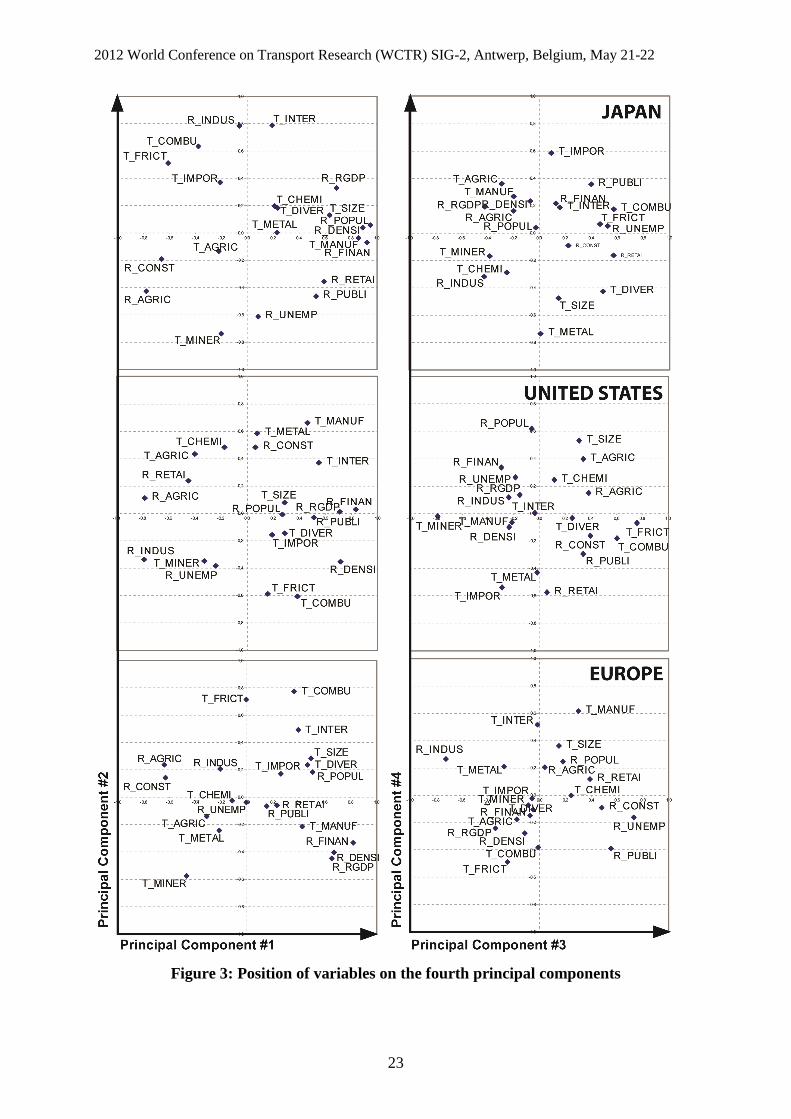
The application of a Principal Components Analysis (PCA) on each of the three datasets
provides some answers to the initial hypotheses (Table 3). Results for Japan exhibit higher
statistical significance, followed by the United States and Europe, thereby reflecting upon
their respective spatial configurations. Due to the presence of many different countries and to
the continental character of hinterlands in Europe, its cumulated variance reaches only 51% at
the fourth principal component, compared with 59% for the United States and 71% for Japan.
The lower score of the United States compared with Japan is also explained by the fact that
some ports serve more distant hinterlands than their adjacent regions, notably through
extensive intermodal services such as by railways. It may thus be interpreted that port-region
linkages have weaker significance in Europe compared with other regions. Nevertheless and
despite such differences, port-region linkages share similar trends across the three areas as
discussed in the following sections and based on Figure 3. A hierarchical clustering was
2012 World Conference on Transport Research (WCTR) SIG-2, Antwerp, Belgium, May 21-22
11
applied to the four main principal components in order to establish a typology of port regions
in each area, where the best represented port regions in each cluster is highlighted.
[Insert Table 3 about here]
[Insert Figure 3 about here]
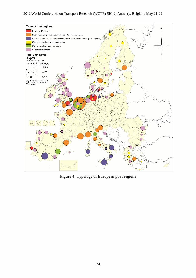
4.2 Europe
European port regions are characterized by an affinity between minerals, metals, agricultural
goods and the agricultural, construction, and industry sectors (PC1). This constitutes a rather
logical association since such sectors mostly need raw materials and intermediate inputs for
performing their activities. This group of variables is opposed to a profile of urban centre
where tertiary activities, especially the financial sector, retail, as well as population, density,
and regional GDP are closer to manufactured goods traffic. The clustering (Figure 4) confirms
that such regions are large coastal capital cities (Oslo, Stockholm, Copenhagen, Hamburg,
London, and Lisbon), mostly located in North Europe (first cluster). Except for Helsinki,
Gdansk, Piraeus, and Bilbao, regions belonging to the second cluster tend to locate close to
Europe's core economic areas, i.e. the European megalopolis from London to Milano. There is
thus a relatively strong influence of continental location on the nature and level of port-region
linkages in Europe. The fact that combustibles, traffic size, international and import traffics
also participate to this trend indicate that those larger and richer regions are mostly consumer
markets best connected to global flows. This trend is very important as it marks a very logical
functional contrast between traditional regions and advanced regions. The cluster of
traditional regions is, indeed, generally located at the periphery of Europe (e.g. Greece,
Atlantic, Scandinavia) despite a few exceptions such as East Flanders, North Brabant, and
Luneburg.
The second trend (PC2) is mostly an opposition between large, international traffic of
combustibles and regions specialized in minerals and metals, with a tendency to be also richer
and more densely populated on average. This can be interpreted as an opposition between a
profile of Maritime Industrial Development Area (MIDA) specialized in the industrial sector
while handling petro-chemical traffics (Vigarié, 1981) and a profile of urban region
specialized in solid bulks and general cargoes. Other trends show an opposition between a
profile of steelworks region (PC3) based on metals traffic and the industrial sector and a
2012 World Conference on Transport Research (WCTR) SIG-2, Antwerp, Belgium, May 21-22
12
profile of deprived region where unemployment is higher than average. On the map, clusters
show a rather strong spatial pattern. Deprived regions (third cluster) are mostly in Southern
Europe (southern Italy, Andalucia) with the exception of Mecklenburg-Vorpommern
(Germany); they have in common to have been the focus of growth pole strategies in the
1970s based on heavy industries as well as container hub strategies in the 1990s (e.g.
Algeciras, Cagliari, Gioia Tauro, Taranto), but such projects have not succeeded in creating
more employment and regional balance, in a context of oil crisis and due to the limited local
economic impacts of container transhipment. This cluster is built in opposition to GDP and
the industrial sector, which suggests lower economic wealth and weaker industrial base.
Another group of regions (fifth cluster) is better defined by specialized traffics serving local
industries specialized in metals and manufactured goods, such as Antwerp, Zeebrugge,
Bremen, and Valencia, with more international openness and stronger socio-economic
backgrounds. Lastly, the most geographically spread category (sixth cluster) is composed of
port regions specialized in combustibles with a high importance of the immediate hinterland
(friction). They have in common to be remotely located from Europe's core economic regions
and/or to face industrial reconversion, such as Dunkirk in the Nord-Pas-de-Calais region as
well as most United Kingdom regions. Their specialization is defined in the cluster in
opposition to the first cluster (GDP, finance, manufactured goods) thereby reinforcing the
idea of relatively deprived regions where heavy industries and lower valued goods dominate.
[Insert Figure 4 about here]
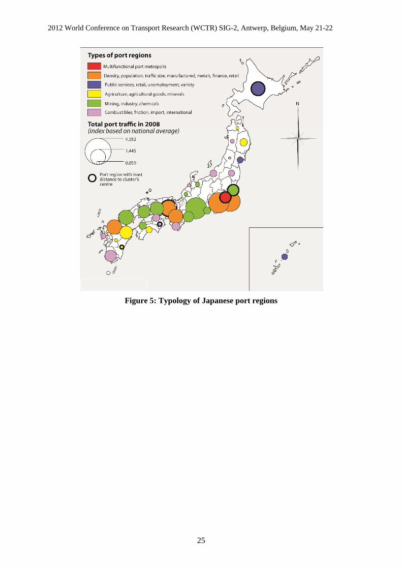
4.3 Japan
The main trend (PC1) opposes large cities to traditional industrial regions. Large traffics and
traffics of manufactured goods are well represented against combustibles and friction. As seen
in Figure 5 (first and second clusters), it corresponds to a handful of large urban regions (i.e.
the Japanese megalopolis from Tokyo to Fukuoka) producing and consuming many value-
added good. Tokyo stands as the only multifunctional centre but it has in common with the
second class important features such as being a large tertiary centre and a large port
simultaneously. This recalls the pattern of hinterlands in Asia (Figure 1) where there is a good
adequacy between economic concentrations and traffic concentrations for the aforementioned
reasons. Such large urban regions handle about half of domestic freight cargo through
interregional flows. Although they are less represented on the first component (PC1),
2012 World Conference on Transport Research (WCTR) SIG-2, Antwerp, Belgium, May 21-22
13
international traffic and traffic diversity are positively correlated with such trends, as well as
retail, thus supporting further the profile of dynamic and global urban regions. On the other
hand, traditional regions are characterized by a coincidence between the agricultural, industry,
and construction sectors and traffics such as combustibles, agricultural goods, and minerals.
This opposition recalls the one found in Europe and provides similar spatial patterns on the
map, with advanced urban regions being core economic regions and traditional regions being
more peripheral (fourth cluster).
The second component opposes a profile of industrial region handling combustibles and
international traffic with a profile of agricultural and deprived region (unemployment) mostly
handling minerals. Thus, the first trend suggests the existence of strong local industry linkages
mostly through importing raw materials for processing plants, again recalling the trend on
Europe based on the concept of MIDA. Such regions have more favourable socio-economic
environments than in the opposed trend as seen with the positive sign for regional GDP; they
serve as strong industrial areas for domestic supply chains, such as Mie, Toyama, Ishikawa,
Aichi, Fukushima, Shizuoka, Fukui, and Ibaraki. The opposed trend comprises two peripheral
regions (Hokkaido and Okinawa) and are not characterized by specific economic functions
except for public services. Other trends point at another opposition between deprived regions
handling large volumes of combustibles and more advanced regions handling mostly raw
materials (minerals, metals) while being specialized in the industrial sector. Those advanced
regions benefit from their inclusion in the megalopolis, they are specialized port regions
complementing the functions of nearby tertiary centres through a spatial division of activities
(i.e. backward linkages) along the main urban corridor of the country.
[Insert Figure 5 about here]
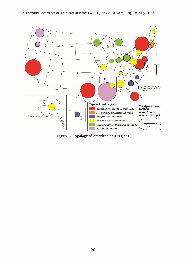
4.4 United States
The case of the United States provides a very clear opposing trend (PC1) between urban
tertiary centres handling most valued goods and traditional regions handling mostly raw
materials, as seen in the two former cases. One common trend with Europe is that, unlike for
Japan, combustibles traffic is grouped with manufactured goods. In fact on the map (Figure
6), it shows the prominence of East coast port regions together with Texas and California,
which concentrate higher-order activities, population, and largest traffics. Massachusetts,
2012 World Conference on Transport Research (WCTR) SIG-2, Antwerp, Belgium, May 21-22
14
Rhode Island, and Connecticut belong to a separate cluster (second) where combustibles are
better represented than in the first class hosting major metropolises. They are functionally and
spatially opposed to port regions located for their majority in the interior and characterized by
agricultural traffics (fourth cluster) and to Midwest regions specialized in the industrial sector
and minerals traffics. Such traditional port regions have also in common certain social
weaknesses due to difficult reconversion (e.g. rustbelt) and declining population. This echoes
a relatively well-known regional geography of the United States where port traffics simply
reflect the dominance of certain local industries. Other port regions are those specialized in
specific industries and traffics and are often geographically confined to certain areas, such as
agricultural and chemicals in the Northwest and at the mouth of the Mississippi (e.g.
Washington, Louisiana), manufactured goods and metals in Georgia and South Carolina.
Those two latter regions have a very diversified industrial background.
[Insert Figure 6 about here]
5. Conclusion
This paper has provided a novel analysis of the interplay between the local socio-economic
conditions of areas surrounding ports and the nature and structure of port traffics, based on a
dataset of 21 indicators covering 189 so-called port regions in Europe, Japan, and the United
States. Main results can be summarized as follows. First, the statistical relationships between
socio-economic variables and port traffic variables are meaningful because they underline
rather logical sector-specific links whereby certain traffics have noticeable affinities with
specific regional characteristics. Thus, despite the probable mismatch between administrative
regions and the true extent of port hinterlands, ports traffics are very sensible to the nature of
the local economy in which they are handled. Second, the three studied geographical areas,
despite wide differences in historical legacies, spatial and trade patterns, share noticeable
similarities in the nature of port-region linkages. Economically and demographically larger,
richer regions where the tertiary sector dominates often concentrate larger, more diversified
traffic volumes as well as higher valued goods such as containers and consumer products, as
opposed with agricultural and industrial regions, which are more specialized in bulk traffics in
relation with their dominant activity. There are, of course, local specificities across the three
regions as such trends are more linear in Japan due to the better overlap between port
hierarchy and urban hierarchy and the simple fact that Japan is an island country thus limiting
2012 World Conference on Transport Research (WCTR) SIG-2, Antwerp, Belgium, May 21-22
15
transit flows. The industrial sector also does not have the same influence on port traffic
specialization depending on the context but overall, there is a striking invariance in the results
beyond local specificities. The typology of port regions obtained through hierarchical
clustering also confirmed a very logical distribution of different types of port-regions
linkages, often showing a contrast between the core (e.g. megalopolises) and the periphery
within the country or continent. The outcomes of the research allow to confirm that port
activities are not disconnected from their local economies, so that further research is needed in
order to push further the analysis of port-region linkages, perhaps by zooming in a more
disaggregated way on traffics and employment sectors, thus allowing to better discuss the
implications of strong port-region linkages on current and future local economic development
opportunities and strategies.
Possible improvements may be obtained by more in-depth reflection about the
correspondence between administrative units where socio-economic data is available and
hinterland patterns, traffic catchment / generation areas around ports. Attributing different
administrative levels to ports according to the volume and nature of their traffics could be one
interesting direction to consider, with smaller and more distance-constrained ports being
bound to lower administrative levels (e.g. NUTS-3 region in Europe, county in the United
States, sub-prefectures and districts in Japan) or city levels (e.g. Functional Urban Areas or
Large Urban Zones in Europe, cities and wards in Japan), while larger ports could be
attributed an intermediate level (NUTS-2, state, prefecture) and largest ports extending across
two or more regions, such as Le Havre and Rouen (France) being counted as ports of the
whole Seine axis including the two NUTS-2 units of Greater Paris region and Upper
Normandy or even the NUTS-1 level comprising Ile-de-France and Bassin Parisien. Perhaps,
such exercise would prove even more successful by considering the spatial layout of the
transport network. In any case the correlation between port traffics and regional specialization
shall be closer to reality, i.e. without amputating too much port hinterlands while remaining
within reasonable geographical limits. Another possible research direction is the extension of
the analysis to other geographical areas where data is potentially available, in the developed
(e.g. Australia, New Zealand, Mexico Canada, South Korea, Hong Kong, Singapore) and
developing (e.g. India, Russia, Brazil, Turkey, China) worlds. This effort would possibly
confirm the existence of invariants in port-region linkages and balance the results obtained
here on developed countries only. Other indicators could be integrated in the analysis, such as
passenger flows (ferry, cruise), flows by other transport modes such as air flows to study their
2012 World Conference on Transport Research (WCTR) SIG-2, Antwerp, Belgium, May 21-22
16
combination with port traffics (see Ducruet et al., 2011), connectivity indicators in maritime
and land-based networks (see Chapelon, 2006; Thill and Lim, 2010), but also other regional
indicators such as about innovation, environment, and wages depending on their large-scale
availability. Lastly, it is fundamental to consider dynamics in both traffics and socio-
economic conditions of port regions, in order to verify possible convergence between
respective diversification and specialization processes and, perhaps, better identify to what
extent changes in port traffic structure not only illustrates but also influences local socio-
economic development.
Acknowledgments
This research has benefitted financial support from the European Commission in the
framework of the European Spatial Planning Observatory Network (ESPON) project on
Territorial Impact of Globalization on Europe and its Regions (TIGER). Authors are grateful
to Marine Le Cam for her support on data collection and preparation.
References
Bird, J. (1971) Seaports and Seaport Terminals (London: Hutchinson). Bird, J. (1983) Gateways: slow recognition but irresistible rise, Tijdschrift voor Economische en Sociale Geografie, 74(3), 196-202. Campbell, S. (1993) Increasing trade, declining port cities: Port containerization and the regional diffusion of economic benefits, in: Noponen, H. et al. (eds.) Trading Industries, Trading Regions: International Trade, American Industry, and Regional Economic Development (New York: Guildford Press). Carter, R.E. (1962) A comparative analysis of United States ports and their traffic characteristics, Economic Geography, 38, 162-175. Chapelon, L. (2006) L’accessibilité, marqueur des inégalités de rayonnement des villes portuaires en Europe, Cybergeo: European Journal of Geography, 345 (online). Charlier, J. (1981) Contribution méthodologique à l’étude des arrière-pays portuaires, Unpublished PhD dissertation in Geography, Louvain, University of Louvain. Charlier, J. (1994) Sur le concept de tonnages pondérés en économie portuaire. L'exemple du Northern Range, Les Cahiers Scientifiques du Transport, 29, 75-84. Cheung, S.M.S., Yip, T.L. (2011) Port city factors and port production: analysis of Chinese ports, Transportation Journal, 50(2), 162-175. Darnton, D.C. (1963) We can have hinterland data, The Professional Geographer, 15(6), 11-13. De Langen, P.W. (2004) Analysing the performance of seaport clusters, in David Pinder and Brian Slack (eds.), Shipping and Ports in the 21st Century (London: Routledge). De Langen, P.W. (2007) The economic performance of seaport regions, in James J. Wang et al. (eds.), Ports, Cities, and Global Supply Chains (Aldershot: Ashgate).
2012 World Conference on Transport Research (WCTR) SIG-2, Antwerp, Belgium, May 21-22
17
Debrie, J., Guerrero, D. (2008) (Re)spatialiser la question portuaire : pour une lecture géographique des arrière-pays européens, L’Espace Géographique, 37(1), 45-56. Dobruszkes, F., Lennert, M., Van Hamme, G. (2011) An analysis of the determinants of air traffic volume for European metropolitan areas, Journal of Transport Geography, 19(4), 755-762. Ducruet, C. (2009) Port regions and globalization, in T.E. Notteboom, C. Ducruet and P.W. De Langen (eds) Ports in Proximity: Competition and Coordination among Adjacent Seaports, Aldershot: Ashgate, pp. 41-53. Ducruet, C. (2011) Activité portuaire et villes, Données Urbaines 6, Economica, Paris, pp. 251-259. Ducruet, C., Ietri, D., Rozenblat, C. (2011) Cities in worldwide air and sea flows: a multiple networks analysis, Cybergeo: European Journal of Geography, 528 (online). Ducruet, C., Koster, R.A., Van der Beek, D.J. (2010) Commodity variety and seaport performance, Regional Studies, 44(9), 1221-1240. Ducruet, C., Lee, S.W. (2006) Frontline soldiers of globalisation: port-city evolution and regional competition, Geojournal, 67(2), 107-122. Ducruet, C., Lee, S.W. (2007) Measuring intermodalism at European port cities: an employment-based approach, World Review of Intermodal Transport Research, 1(3), 313-334. Ducruet, C., Lugo, I. (2012) Structure and dynamics of transportation networks: models, methods, and applications, in: Rodrigue, J.P., Shaw, J. and Notteboom, T.E. (eds.), The SAGE Handbook of Transport Studies (in press). Dunford, M., Yeung, G. (2009) Regional development: port-industrial complexes, in Kitchin, Rob and Thrift, Nigel (eds.) International Encyclopedia of Human Geography. Amsterdam: Elsevier. Volume 8, pp. 285-294. Eagle, N., Macy, M., Claxton, R. (2010) Network diversity and economic development, Science, 328, 1029-1031. Fujita, M., Krugman, P., Venables A.J. (1999) The Spatial Economy: Cities, Regions and International Trade (Cambridge & London: MIT Press). Fujita, M., Mori, T. (1996) The role of ports in the making of major cities: Self-agglomeration and hub-effect, Journal of Development Economics, 49(1), 93-120. Garnier, J., Zimmermann, J.B. (2004) L'aire métropolitaine marseillaise et les territoires de l'industrie, LEST-GREQAM Working Paper. Goetz, A.R., Vowles, T.M., Tierney, S. (2009) Bridging the qualitative–quantitative divide in transport geography?, The Professional Geographer, 61, 323-335. Gouvernal, E., Slack, B., Franc, P. (2010) Short sea and deep sea shipping markets in France, Journal of Transport Geography, 18, 97-103. Grobar, L.M. (2008) The economic status of areas surrounding major U.S. container ports: Evidence and policy issues, Growth and Change, 39(3), 497-516. Guerrero, D. (2010) Les aires d'influence des ports de la France entre réseau et gravitation, Unpublished PhD dissertation in Geography, Paris Diderot – Paris VII University. Haddad, E.A., Hewings, G.J.D., Antonio dos Santos, R. (2005) Port efficiency and regional development, Unpublished paper, Associação Nacional dos Centros de Pós-Graduação em Economia, Niteroi RJ, Brazil, http://www.anpec.org.br/ encontro2006/artigos/A06A050.pdf Haefner, L.E., Lang, D.E., Cronin, T. (1980) Forecast of key commodity flows at a regional port, Transportation Research Record, 763, 2-5. Haezendonck, E. (2001) Essays on Strategy Analysis for Seaports, Garant Publishers, Louvain. Hall, P.V. (2002) The Institution of Infrastructure and the Development of Port-regions, Unpublished PhD Dissertation (Berkeley: University of California).
2012 World Conference on Transport Research (WCTR) SIG-2, Antwerp, Belgium, May 21-22
18
Hall, P.V. (2004a) ’We’d have to sink the ships’: Impact studies and the 2002 West Coast port lockout, Economic Development Quarterly, 18(4), 354-367. Hall, P.V. (2004b) Mutual specialization, seaports and the geography of automobile imports, Tijdschrift voor Economische en Sociale Geografie, 95(2), 135-146. Hall, P.V. (2009) Container ports, local benefits and transportation worker earnings, Geojournal, 74(1), 67-83. Hall, P.V., Jacobs, W. (2012) Why are maritime ports (still) urban, and why should policy makers care?, Maritime Policy and Management, 39(2), 189-206. Hesse, M., Rodrigue, J.P. (2004) The transport geography of logistics and freight distribution, Journal of Transport Geography, 12, 171-184. Hesse, M. (2010) Cities, material flows and the geography of spatial interaction: urban places in the system of chains, Global Networks, 10(1), 75-91. Hoare, A.G. (1986) British ports and their export hinterlands: A rapidly changing geography, Geografiska Annaler, 68B(1), 29-40. Jacobs, W., Ducruet, C. De Langen, P.W. (2010) Integrating world cities into production networks: the case of port cities, Global Networks, 10(1): 92-113. Jacobs, W., Koster, H.R.A., Hall, P.V. (2011) The location and global network structure of maritime advanced producer services, Urban Studies, 48(13), 2749-2769. Janelle, D.G., Beuthe, M. (1997) Globalization and research issues in transportation, Journal of Transport Geography, 5(3), 199-206. Kuby, M., Reid, N. (1992) Technological change and the concentration of the U.S. general cargo port system: 1970-88, Economic Geography, 68, 272-89. Lee, S.W., Song, D.W., Ducruet, C. (2008) A tale of Asia’s world ports: the spatial evolution in global hub port cities, Geoforum, 39(1): 372-385. Lee, S.W., Ducruet, C. (2009) Spatial glocalization in Asia-Pacific hub port cities: A comparison of Hong Kong and Singapore, Urban Geography, 30(2), 161-184. Leslie, D. and Reimer, S. (1999) Spatializing commodity chains, Progress in Human Geography, 23(3), 401-20. Lever, W.F. (1995) Regional economic growth and port activities in European cities, Proceedings of the 5th International Conference Cities and Ports, Dakar, Senegal, pp. 309-316. Marti, B.E. (1985) Chilean ports: commodity specialization and potential for containerization, The Professional Geographer, 37, 320-328. McCalla, R.J., Slack, B., Comtois, C. (2001) Intermodal freight terminals: locality and industrial linkages, The Canadian Geographer, 45(3), 404-413. McCalla, R.J., Slack, B., Comtois, C. (2004) Dealing with globalisation at the regional and local levels: The case of contemporary containerization, The Canadian Geographer, 48(4), 473-487. Musso, E., Benacchio, M., Ferrari, C. (2000) Ports and employment in port cities, International Journal of Maritime Economics, 2, 283-311. Notteboom, T.E., Rodrigue, J.P. (2005) Port regionalization: Toward a new phase in port development, Maritime Policy and Management, 32(3), 297-313. Neal, Z.P. (2011) The causal relationship between employment and business networks in U.S. cities, Journal of Urban Affairs, 33(2), 167-184. Ng, A.K.Y. (2009) Port competition: The case of North Europe. Saarbrucken: VDM Publishing. Patton, D.J. (1958) General cargo hinterlands of New York, Philadelphia, Baltimore, and New Orleans, Annals of the Association of American Geographers, 48(4), 436-455.
2012 World Conference on Transport Research (WCTR) SIG-2, Antwerp, Belgium, May 21-22
19
Rodrigue, J.P. (2003) The Port Authority of New York and New Jersey: Global changes, regional gains and local challenges in port development, Les Cahiers Scientifiques du Transport, 44, 55-75. Rodrigue, J.P., Comtois, C., Slack, B. (2009) The Geography of Transport Systems (New York: Routledge). Rodrigue, J.P., Notteboom, T.E. (2010) Comparative North American and European gateway logistics: the regionalism of freight distribution, Journal of Transport Geography, 18(4), 497-507. Stern, E., Hayuth, Y. (1984) Developmental effects of geopolitically located ports, in Brian S. Hoyle and David Hilling (eds.), Seaport Systems and Spatial Change (Chichester: Wiley). Thill, J.C., Lim, H. (2010) Intermodal containerized shipping in foreign trade and regional accessibility advantages, Journal of Transport Geography, 18(4), 530-547. Todd, D. (1993) The interplay of trade, regional and technical factors in the evolution of a port system: The case of Taiwan, Geografiska Annaler, 75B(1), 3-18. Vallega, A. (1996) Cityports, coastal zones and sustainable development, in Brian S. Hoyle (ed.), Cityports, Coastal Zones and Regional Change (Chichester: Wiley). Van der Lugt, L., De Langen, P.W. (2005) Ports as locations for logistics activities, Journal of International Trade and Logistics, 3(2), 59-72. Vigarié, A. (1981) Maritime Industrial Development Areas: Structural evolution and implications for regional development, in Brian S. Hoyle and David A. Pinder (eds.), Cityport Industrialization and Regional Development (Oxford: Pergamon Press). Vleugels, R.L.M. (1969) The economic impact of ports on the regions they serve and the role of industrial development, Paper presented at the 6th Biennial Conference of the International Association of Ports and Harbors, Melbourne, Australia, March. Wang, J., Mo, H., Wang, F., Jin, F. (2011) Exploring the network structure and nodal centrality of China's air transport network: A complex network approach, Journal of Transport Geography, 19(4), 712-721. Wang, J.J., Chen, M.C. (2010) From a hub port city to a global supply chain management center: a case study of Hong Kong, Journal of Transport Geography, 18(1), 104-115.
2012 World Conference on Transport Research (WCTR) SIG-2, Antwerp, Belgium, May 21-22
20
Port
Total port traffic * Share of the local
administrative unit in total port traffic *
Container traffic **
Volume (tons)
Value (Euros)
Volume (%) Value (%) Volume (tons)
Share in total port traffic (%)
Rouen 8,942,804 10,525,770 69.0 13.5 1,136,000 5.2 Le Havre 8,305,550 29,213,899 22.8 13.4 17,685,000 25.0 Marseille 7,019,774 7,986,530 64.5 22.3 7,292,000 7.8 Dunkerque 3,937,047 2,294,024 79.8 41.5 1,559,000 3.2 Nantes-St. Nazaire 2,631,685 959,309 73.5 54.1 1,169,000 3.4 Languedoc-Roussillon (a) 2,041,343 534,717 76.5 73.2 61,000 1.6 Bordeaux 1,292,146 392,860 95.3 78.2 444,000 5.2 Bretagne (a) 1,242,471 388,765 99.5 97.9 234,000 9.6 La Rochelle 1,074,273 155,471 99.6 96.8 0 0.0 Dieppe 326,985 104,036 78.7 37.3 38,000 3.8 Boulogne 42,879 27,760 57.4 26.9 0 0.0
Table 1: Weight and share of coastal regions in French ports' traffics in 2005
Sources : calculated based on * Guerrero (2010) and ** Eurostat
(a) reference is the Région instead of Département
N.B. data accounts for extra-EU maritime flows excluding oil products
Type of indicator
Code Specialization Code General
characteristics
Port traffic
T_COMBUS *Combustibles (coal, oil, gas) T_SIZE *Traffic size
T_CHEMI *Chemical products & fertilizers
T_IMPOR *Import/inbound traffic
T_METAL *Metal products (iron & steel, scrap) T_INTER *International traffic
T_AGRIC *Agricultural, forestry products & live animals
T_DIVER *Commodity diversity
T_MINER *Minerals & construction materials (ores, sand, gravel)
T_FRICT ***Spatial friction
T_MANUF *Manufactured goods (containers, vehicles, food products)
Socio-economic
R_AGRIC **Employment in agriculture and fisheries R_POPUL *Demographic size
R_CONST **Employment in construction R_DENSI *Population density
R_INDUS **Employment in mining & manufacturing R_UNEMP **Unemployment
R_RETAI **Employment in retail, hotel, & transport R_RGDP **GDP per capita
R_FINAN **Employment in finance & real estate
R_PUBLI **Employment in public services
Table 2: List of traffic and regional indicators
* index based on national/continental average ** index based on national average *** other method
2012 World Conference on Transport Research (WCTR) SIG-2, Antwerp, Belgium, May 21-22
21
Area PC1 PC2 PC3 PC4 PC5 PC6
Eigenvalues
Europe 4.086 2.623 2.264 1.784 1.299 1.191 Japan 6.666 3.752 2.390 2.108 1.358 0.954 USA 4.738 2.919 2.661 2.094 1.904 1.485
Cumulated variance
Europe 19.456 31.945 42.725 51.219 57.403 63.072 Japan 31.742 49.610 60.992 71.032 77.500 82.040 USA 22.560 36.460 49.133 59.103 68.168 75.238
Table 3: Main results of the Principal Component Analysis (PCA)
Figure 1: Hinterland patterns of some large regions
Source: Lee et al. (2008)
2012 World Conference on Transport Research (WCTR) SIG-2, Antwerp, Belgium, May 21-22
22
Figure 2: Correlations among all variables in 2008 by geographic area
2012 World Conference on Transport Research (WCTR) SIG-2, Antwerp, Belgium, May 21-22
23
Figure 3: Position of variables on the fourth principal components
2012 World Conference on Transport Research (WCTR) SIG-2, Antwerp, Belgium, May 21-22
24
Figure 4: Typology of European port regions
2012 World Conference on Transport Research (WCTR) SIG-2, Antwerp, Belgium, May 21-22
25
Figure 5: Typology of Japanese port regions
2012 World Conference on Transport Research (WCTR) SIG-2, Antwerp, Belgium, May 21-22
26
Figure 6: Typology of American port regions