Embed Size (px)
Citation preview

Prepared by:
MasterMasterDevelopmentDevelopment
PlanPlan20112011
Master D
evelopment Plan
Master D
evelopment Plan
20112011
R
Master Development Plan
Monarch, Colorado
2011
Prepared by:
Ketchum, ID Salt Lake City, UT Frisco, CO Burlington, VT

Monarch Mountain Master Development Plan - 2011
i
TABLE OF CONTENTS
I. INTRODUCTION ................................................................................................................................ I-1
A. BACKGROUND ........................................................................................................................................ I-1 1. History ....................................................................................................................................................... I-1
B. ABSTRACT OF PROPOSED MASTER DEVELOPMENT PLAN............................................................................. I-2 1. Terrain ....................................................................................................................................................... I-3 2. Lifts ............................................................................................................................................................ I-3 3. Special Use Permit Boundary Adjustment ............................................................................................ I-3 4. Guest Services ......................................................................................................................................... I-3 5. Infrastructure ........................................................................................................................................... I-4 6. Alternative Winter Recreation ............................................................................................................... I-4
C. DEVELOPMENT PHILOSOPHY (GOALS AND OBJECTIVES) ............................................................................ I-4
II. DESIGN CRITERIA............................................................................................................................. II-1
A. REGIONAL DESTINATION SKI AREAS .......................................................................................................... II-1 B. MOUNTAIN DESIGN ................................................................................................................................ II-1
1. Trail Design .............................................................................................................................................. II-1 2. Lift Design ................................................................................................................................................ II-4 3. Capacity Analysis and Design ............................................................................................................. II-4
C. BASE AREA DESIGN ................................................................................................................................ II-4 D. BALANCE OF FACILITIES ........................................................................................................................... II-4 E. APPLICABLE FOREST SERVICE POLICY DIRECTION ...................................................................................... II-5
1. Pertinent Forest Plan Direction .............................................................................................................. II-5 2. Recreation Opportunity Spectrum ...................................................................................................... II-7 3. Scenery Management .......................................................................................................................... II-8 4. Accessibility to Public Lands ................................................................................................................. II-9
III. SITE INVENTORY .............................................................................................................................. III-1
A. PHYSICAL RESOURCES ............................................................................................................................ III-1 1. Topography ........................................................................................................................................... III-1 2. Slope Gradients .................................................................................................................................... III-1 3. Slope Aspect ......................................................................................................................................... III-2 4. Fall Line .................................................................................................................................................. III-2
B. PERMIT BOUNDARY AND LAND OWNERSHIP ............................................................................................ III-3 1. Existing SUP ............................................................................................................................................ III-3 2. Proposed SUP Adjustment .................................................................................................................... III-3
C. ENVIRONMENTAL RECONNAISSANCE ...................................................................................................... III-3
IV. EXISTING FACILITIES INVENTORY AND ANALYSIS ........................................................................ IV-1
A. SUMMARY OF GUEST EXPERIENCE .......................................................................................................... IV-1 B. ALPINE FACILITIES (LIFTS AND TERRAIN) .................................................................................................... IV-1
1. Lifts ......................................................................................................................................................... IV-1 2. Alpine Terrain ........................................................................................................................................ IV-3 3. Terrain Parks .......................................................................................................................................... IV-5
C. COMFORTABLE CARRYING CAPACITY (CCC) ...................................................................................... IV-6 D. SKI TRAIL DENSITY ANALYSIS ................................................................................................................... IV-7 E. SNOWMAKING COVERAGE ................................................................................................................... IV-8 F. GROOMING OPERATIONS ..................................................................................................................... IV-8 G. SKIER SERVICES SPACE AND FOOD SERVICE SEATING .............................................................................. IV-8
1. Skier Services ........................................................................................................................................ IV-8 2. Food Service Seating......................................................................................................................... IV-10
H. PARKING CAPACITY............................................................................................................................ IV-12 I. BALANCE OF FACILITIES ....................................................................................................................... IV-13
Monarch Mountain Master Development Plan - 2011
ii
J. ALTERNATIVE WINTER RECREATION....................................................................................................... IV-14 K. OPERATIONS (MAINTENANCE, UTILITIES) ............................................................................................... IV-14
1. Maintenance Facility ......................................................................................................................... IV-14 2. Utilities .................................................................................................................................................. IV-15
L. SUMMER RECREATIONAL OPPORTUNITIES .............................................................................................. IV-16
V. PREVIOUSLY APPROVED PROJECTS, NOT YET IMPLEMENTED ....................................................... V-1
A. LIFTS ...................................................................................................................................................... V-1 1. Breezeway Lift ....................................................................................................................................... V-1 2. Snowflake Surface Lift .......................................................................................................................... V-1
B. TERRAIN................................................................................................................................................. V-1 1. Trail Development ................................................................................................................................. V-2 2. Trail Widening ........................................................................................................................................ V-2
C. FACILITIES .............................................................................................................................................. V-2 1. Mountain-Top Facility ........................................................................................................................... V-2 2. Mid-Mountain Facility ........................................................................................................................... V-2
D. SNOWMAKING ....................................................................................................................................... V-2 E. PREVIOUSLY APPROVED PROJECTS NOT CONTAINED WITHIN THIS MDP .................................................... V-3
1. Gunbarrel Surface Lift .......................................................................................................................... V-3 2. Snowplay Area ...................................................................................................................................... V-3 3. Maintenance Facility ............................................................................................................................ V-3
VI. PROPOSED UPGRADING PLAN ...................................................................................................... VI-1
A. SUMMARY OF UPGRADING PLAN ........................................................................................................... VI-1 B. ALPINE FACILITIES (LIFTS AND TERRAIN) ................................................................................................... VI-1
1. Ski Area-Wide Upgrades (Front-side and No Name Basin) ............................................................. VI-1 2. Front-side Lifts and Terrain ................................................................................................................... VI-4 3. SUP Boundary Adjustment and Associated Lift and Terrain ............................................................ VI-5
C. COMFORTABLE CARRYING CAPACITY ................................................................................................... VI-6 D. SKI TRAIL DENSITY ANALYSIS ................................................................................................................... VI-6 E. SNOWMAKING COVERAGE ................................................................................................................... VI-7 F. GROOMING OPERATIONS ..................................................................................................................... VI-7 G. SKIER SERVICES SPACE AND FOOD SERVICE SEATING .............................................................................. VI-7
1. Skier Services ........................................................................................................................................ VI-8 2. Food Service Seating......................................................................................................................... VI-11
H. PARKING CAPACITY............................................................................................................................ VI-11 I. BALANCE OF FACILITIES ....................................................................................................................... VI-12 J. ALTERNATIVE WINTER RECREATION....................................................................................................... VI-13 K. OPERATIONS (SKI PATROL/FIRST AID, MAINTENANCE, UTILITIES) ............................................................. VI-13
1. Ski Patrol / First Aid ............................................................................................................................. VI-13 2. Maintenance ..................................................................................................................................... VI-14 3. Snowcat Storage ............................................................................................................................... VI-14 4. Utilities .................................................................................................................................................. VI-14 5. Snow Storage ..................................................................................................................................... VI-15
L. SUMMER RECREATION ......................................................................................................................... VI-15
VII. GLOSSARY ..................................................................................................................................... VII-1
Monarch Mountain Master Development Plan - 2011
iii
APPENDIX A
TABLE 1: LIFT SPECIFICATIONS – EXISTING CONDITIONS TABLE 2: LIFT SPECIFICATIONS – UPGRADING PLAN TABLE 3: TERRAIN SPECIFICATIONS – EXISTING CONDITIONS TABLE 4: TERRAIN SPECIFICATIONS – UPGRADING PLAN TABLE 5: DAILY LIFT CAPACITY – EXISTING CONDITIONS TABLE 6: DAILY LIFT CAPACITY – UPGRADING PLAN TABLE 7: DENSITY ANALYSIS – EXISTING CONDITIONS TABLE 8: DENSITY ANALYSIS – UPGRADING PLAN TABLE 9: SPACE USE INVENTORY FOR BASE AREA FACILITIES – EXISTING CONDITIONS TABLE 10: SPACE USE INVENTORY FOR BASE AREA FACILITIES – UPGRADING PLAN TABLE 11: SPACE USE INVENTORY FOR ON-MOUNTAIN FACILITIES – EXISTING CONDITIONS TABLE 12: SPACE USE INVENTORY FOR ON-MOUNTAIN FACILITIES – UPGRADING PLAN TABLE 13: SPACE USE INVENTORY FOR RESORT-WIDE FACILITIES – UPGRADING PLAN TABLE 14: RECOMMENDED RESTAURANT SEATS – UPGRADING PLAN
LIST OF TABLES
TABLE I-1: TOTAL ANNUAL SKIER VISITATION AT MONARCH MOUNTAIN COMPARED TO THE STATE OF COLORADO ..... I-5 TABLE II-1: TERRAIN GRADIENTS ............................................................................................................................. II-2 TABLE II-2: CENTRAL ROCKY MOUNTAIN SKIER ABILITY BREAKDOWN ....................................................................... II-2 TABLE II-3: SKIER DENSITY PER ACRE....................................................................................................................... II-2 TABLE IV-1: TERRAIN DISTRIBUTION BY ABILITY LEVEL – EXISTING CONDITIONS ......................................................... IV-4 TABLE IV-2: SPACE USE ANALYSIS – EXISTING CONDITIONS ................................................................................... IV-9 TABLE IV-3: EXISTING AND REQUIRED RESTAURANT SEATS AND SEATING CAPACITY .............................................. IV-11 TABLE IV-4: EXISTING PARKING AT BASE AREA ................................................................................................... IV-13 TABLE VI-1: TERRAIN DISTRIBUTION BY ABILITY LEVELS – UPGRADING PLAN ............................................................. VI-3 TABLE VI-2: PROPOSED PARKING ...................................................................................................................... VI-12
LIST OF CHARTS
CHART IV-1: TERRAIN DISTRIBUTION BY ABILITY LEVEL – EXISTING CONDITIONS ....................................................... IV-5 CHART IV-2: SKI AREA BALANCE – EXISTING CONDITIONS .................................................................................. IV-14 CHART VI-1: TERRAIN DISTRIBUTION BY ABILITY LEVEL – UPGRADING PLAN ............................................................ VI-3 CHART VI-2: SKI AREA BALANCE – UPGRADING PLAN ....................................................................................... VI-13
Monarch Mountain Master Development Plan - 2011
iv
LIST OF FIGURES
FIGURE I-1: LOCATION MAP FIGURE I-2: PROJECT AREA FIGURE III-1: SLOPE ANALYSIS FIGURE III-2: ASPECT ANALYSIS FIGURE III-3: ELEVATION ANALYSIS FIGURE III-4: FALL LINE ANALYSIS FIGURE IV-1: EXISTING CONDITIONS FIGURE IV-2: BASE AREA EXISTING CONDITIONS FIGURE VI-1: PREVIOUSLY APPROVED AND PROPOSED PROJECTS FIGURE VI-2: BASE AREA PREVIOUSLY APPROVED AND PROPOSED PROJECTS FIGURE VI-3: USFS MANAGEMENT AREA WITH PROPOSED NO NAME BASIN PROJECT COMPONENTS

Chapter 1 Introduction

Monarch Mountain Master Development Plan - 2011
I-1
I. INTRODUCTION
This Master Development Plan (MDP) has been prepared to provide a thorough assessment of existing operations and facilities at Monarch Mountain (Monarch), and to identify a comprehensive plan for future improvements to the ski area. The MDP is designed to guide the ski area in creating a balanced recreation experience which is appealing to guests and is operationally efficient. In addition, the plan is respectful of the natural resources within the study area while incorporating important guest preferences and addressing increasing skier visitation and demand. The MDP is designed to be a dynamic document which may be amended periodically to reflect innovation in facilities and recreation.
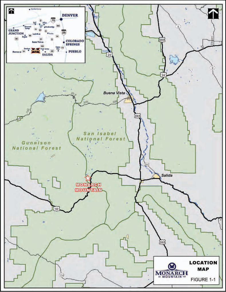
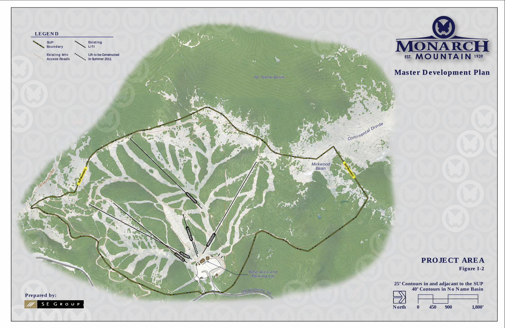
A. BACKGROUND Monarch is located in the San Isabel National Forest, in Chaffee County, Colorado. The ski area is located approximately 20 miles west of Salida, Colorado, in the Sawatch Mountain Range (refer to Figure I-1). The nearest private lands are located approximately 1 mile to the east at the Madonna Mine site. Monarch is accessed via U.S. Highway 50, a major east-west thoroughfare in south-central Colorado. The ski area occupies approximately 800 acres of forested and developed land on the east side of the Continental Divide, and is located entirely on National Forest System (NFS) lands. Elevations range from 10,790 feet elevation at the base of the ski slopes to 11,942 feet at the summit (refer to Figure I-2).
1. History Monarch opened to the public in 1939 as a Works Progress Administration (WPA) project with a single rope tow that ran from what is now the parking lot to the top of the Gunbarrel trail. Upon completion of the project, the ski area was given to the City of Salida to provide winter recreation opportunities for citizens of Salida and south-central Colorado. Soon after acquiring a U.S. Forest Service (Forest Service) Special Use Permit (SUP), the City of Salida installed a second rope tow and a rustic, log day lodge which was without electricity or running water.
With the increased popularity of recreational skiing in the mid-1950s, the ski area’s lift capacity fell short of skier demand and it became apparent that upgrades to the ski area’s infrastructure were needed. In 1955, the City of Salida sold Monarch to Ray Berry, the ski area’s general manager. Berry added to Monarch’s infrastructure with the installation of a T-Bar in 1957, Monarch’s first aerial lift in 1960, the clearing of many trails, and upgrading the base facilities in 1965. In 1967, majority ownership changed again, and in order to meet the demand of the skiing public, the Breezeway and Garfield lifts were installed in 1968 and 1969, respectively.
During the 1979/80 season, Monarch was sold again to Westlake Mortgage and Investment Corporation. Improvements to Monarch under this ownership included the installation of the Panorama lift, providing Monarch with a third double chairlift. During the summer of 1981, the Tumbelina lift replaced an existing Poma lift to service Monarch’s teaching terrain. The Tumbelina lift was installed with a mid-unload station to facilitate beginner, round-trip skiing on the Snowflake trail.
Monarch Mountain Master Development Plan - 2011
I-2
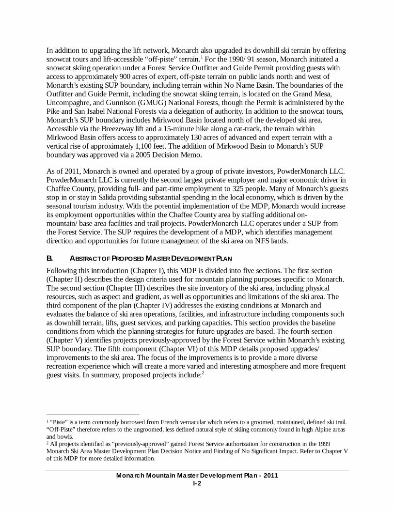
In addition to upgrading the lift network, Monarch also upgraded its downhill ski terrain by offering snowcat tours and lift-accessible “off-piste” terrain.1 For the 1990/91 season, Monarch initiated a snowcat skiing operation under a Forest Service Outfitter and Guide Permit providing guests with access to approximately 900 acres of expert, off-piste terrain on public lands north and west of Monarch’s existing SUP boundary, including terrain within No Name Basin. The boundaries of the Outfitter and Guide Permit, including the snowcat skiing terrain, is located on the Grand Mesa, Uncompaghre, and Gunnison (GMUG) National Forests, though the Permit is administered by the Pike and San Isabel National Forests via a delegation of authority. In addition to the snowcat tours, Monarch’s SUP boundary includes Mirkwood Basin located north of the developed ski area. Accessible via the Breezeway lift and a 15-minute hike along a cat-track, the terrain within Mirkwood Basin offers access to approximately 130 acres of advanced and expert terrain with a vertical rise of approximately 1,100 feet. The addition of Mirkwood Basin to Monarch’s SUP boundary was approved via a 2005 Decision Memo.
As of 2011, Monarch is owned and operated by a group of private investors, PowderMonarch LLC. PowderMonarch LLC is currently the second largest private employer and major economic driver in Chaffee County, providing full- and part-time employment to 325 people. Many of Monarch’s guests stop in or stay in Salida providing substantial spending in the local economy, which is driven by the seasonal tourism industry. With the potential implementation of the MDP, Monarch would increase its employment opportunities within the Chaffee County area by staffing additional on-mountain/base area facilities and trail projects. PowderMonarch LLC operates under a SUP from the Forest Service. The SUP requires the development of a MDP, which identifies management direction and opportunities for future management of the ski area on NFS lands.
B. ABSTRACT OF PROPOSED MASTER DEVELOPMENT PLAN Following this introduction (Chapter I), this MDP is divided into five sections. The first section (Chapter II) describes the design criteria used for mountain planning purposes specific to Monarch. The second section (Chapter III) describes the site inventory of the ski area, including physical resources, such as aspect and gradient, as well as opportunities and limitations of the ski area. The third component of the plan (Chapter IV) addresses the existing conditions at Monarch and evaluates the balance of ski area operations, facilities, and infrastructure including components such as downhill terrain, lifts, guest services, and parking capacities. This section provides the baseline conditions from which the planning strategies for future upgrades are based. The fourth section (Chapter V) identifies projects previously-approved by the Forest Service within Monarch’s existing SUP boundary. The fifth component (Chapter VI) of this MDP details proposed upgrades/ improvements to the ski area. The focus of the improvements is to provide a more diverse recreation experience which will create a more varied and interesting atmosphere and more frequent guest visits. In summary, proposed projects include:2
1 “Piste” is a term commonly borrowed from French vernacular which refers to a groomed, maintained, defined ski trail. “Off-Piste” therefore refers to the ungroomed, less defined natural style of skiing commonly found in high Alpine areas and bowls. 2 All projects identified as “previously-approved” gained Forest Service authorization for construction in the 1999 Monarch Ski Area Master Development Plan Decision Notice and Finding of No Significant Impact. Refer to Chapter V of this MDP for more detailed information.

Monarch Mountain Master Development Plan - 2011
I-3
1. Terrain • Implement the previously-approved 14 acres of trail widening within the existing terrain
network
• Implement the previously-approved 4 acres of new ski trail development
• Implement approximately 1.5 acres of widening and clearing and approximately 6 acres of grading on the front-side
• Glade approximately 48 acres within Monarch’s current terrain network
• Develop approximately 62 acres of new trails within No Name Basin
• Develop approximately 58 acres of gladed skiing opportunities within No Name Basin
2. Lifts • Update previous approval for the Breezeway lift to a fixed-grip, triple chair, with a shortened
lift alignment and associated grading near the bottom terminal to ease lift access
• Install a fixed-grip double chairlift in No Name Basin
• Relocate the Safari conveyor lifts
• Install two conveyor lifts adjacent to the Safari and Congo lifts
3. Special Use Permit Boundary Adjustment • Adjust the current SUP boundary to include a portion of No Name Basin, terrain within the
existing Outfitter and Guide Permit area that is located on the GMUG National Forest
4. Guest Services • Construct the previously-approved 300-square foot mid-mountain facility with a 150-seat
sun deck and adjacent composting toilets building
• Construct the previously-approved 756 square foot mountain-top facility, including 50 seats and restrooms
• Construct an 8,000-square foot ski school/children’s center structure adjacent to the existing sprung structure in the base area
• Construct an addition to the three floors of the existing base lodge, bar and restaurant seating, the sack lunch area, along with storage space will be expanded upon and improved in this addition
• Construct a 5,000-square foot overflow restaurant seating building with office and admin space adjacent to the day lodge
• Relocate the existing Children’s Center modular building to function as a guest service building at the planned tubing facility
• Relocate the existing employee ski storage hut to the tubing facility for storage capacity
• Replace the existing Ski Patrol building with a 3,000 square foot two story building that will include Patrol Headquarters on the upper floor and medical clinic on the lower floor
Monarch Mountain Master Development Plan - 2011
I-4
• Relocate the existing Ski Patrol building adjacent to the maintenance shop to be used as offices for the Lift and Slope Maintenance departments
• Construct an approximately 750-square yurt adjacent to the existing Ski Patrol building for the Monarch Snowcat Tours, meeting location, check-in, lunch, and check-out
• Construct an approximately 750-square foot warming hut at the bottom of the proposed No Name lift within No Name Basin
5. Infrastructure • Previously-approved snowmaking operations on 33 acres of existing ski terrain
• Develop approximately 2.7 acres of parking in two locations providing 320 additional parking spaces
• Develop an additional 2,100 square feet to expand on to the existing waste water treatment facility
• Construct a 4,000 square foot building adjacent to the existing maintenance facility to be used as the new Vehicle Maintenance shop (existing shop will continue to be used for vehicle and lift maintenance along with a carpentry and paint shop)
• Relocate the cabin presently being used by the Lift Maintenance operations to the bottom of Panorama to accompany the mid-mountain facility to use as storage and preserve the building’s historical significance
• Relocate the explosive cache and make-up room away from the planned tubing facility and closer to the Mirkwood egress trail
6. Alternative Winter Recreation • Development of snowtubing facility adjacent to existing parking and trail network
As a result of previously-approved and proposed projects, Monarch’s Comfortable Carrying Capacity (CCC) will increase from 2,870 guests to 3,490 guests (an increase of 22%).3
C. DEVELOPMENT PHILOSOPHY (GOALS AND OBJECTIVES) Historical annual skier visitation at Monarch is attributable to its long history as an affordable day-use ski area accommodating guests from the Chaffee County area as well as the Colorado Front Range.
As demonstrated in Table I-1, skier visits at Monarch have fluctuated each year since the late 1990s, with steady positive growth.
3 Comfortable Carrying Capacity (CCC) is a planning tool used to determine the optimum level of utilization that facilitates a pleasant recreational experience. This is a planning figure only and does not represent a regulatory cap on visitation. CCC is used to ensure that different aspects of a resort’s facilities are designed to work in harmony, that capacities are equivalent across facilities, and sufficient to meet anticipated demand. CCC is based on factors such as vertical transport and trail capacities.
Monarch Mountain Master Development Plan - 2011
I-5
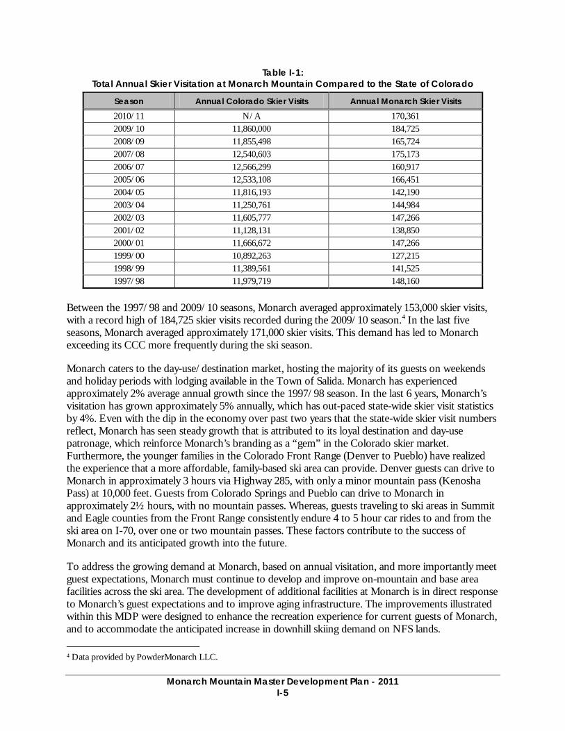
Table I-1: Total Annual Skier Visitation at Monarch Mountain Compared to the State of Colorado
Season Annual Colorado Skier Visits Annual Monarch Skier Visits
2010/11 N/A 170,361 2009/10 11,860,000 184,725 2008/09 11,855,498 165,724 2007/08 12,540,603 175,173 2006/07 12,566,299 160,917 2005/06 12,533,108 166,451 2004/05 11,816,193 142,190 2003/04 11,250,761 144,984 2002/03 11,605,777 147,266 2001/02 11,128,131 138,850 2000/01 11,666,672 147,266 1999/00 10,892,263 127,215 1998/99 11,389,561 141,525 1997/98 11,979,719 148,160
Between the 1997/98 and 2009/10 seasons, Monarch averaged approximately 153,000 skier visits, with a record high of 184,725 skier visits recorded during the 2009/10 season.4 In the last five seasons, Monarch averaged approximately 171,000 skier visits. This demand has led to Monarch exceeding its CCC more frequently during the ski season.
Monarch caters to the day-use/destination market, hosting the majority of its guests on weekends and holiday periods with lodging available in the Town of Salida. Monarch has experienced approximately 2% average annual growth since the 1997/98 season. In the last 6 years, Monarch’s visitation has grown approximately 5% annually, which has out-paced state-wide skier visit statistics by 4%. Even with the dip in the economy over past two years that the state-wide skier visit numbers reflect, Monarch has seen steady growth that is attributed to its loyal destination and day-use patronage, which reinforce Monarch’s branding as a “gem” in the Colorado skier market. Furthermore, the younger families in the Colorado Front Range (Denver to Pueblo) have realized the experience that a more affordable, family-based ski area can provide. Denver guests can drive to Monarch in approximately 3 hours via Highway 285, with only a minor mountain pass (Kenosha Pass) at 10,000 feet. Guests from Colorado Springs and Pueblo can drive to Monarch in approximately 2½ hours, with no mountain passes. Whereas, guests traveling to ski areas in Summit and Eagle counties from the Front Range consistently endure 4 to 5 hour car rides to and from the ski area on I-70, over one or two mountain passes. These factors contribute to the success of Monarch and its anticipated growth into the future.
To address the growing demand at Monarch, based on annual visitation, and more importantly meet guest expectations, Monarch must continue to develop and improve on-mountain and base area facilities across the ski area. The development of additional facilities at Monarch is in direct response to Monarch’s guest expectations and to improve aging infrastructure. The improvements illustrated within this MDP were designed to enhance the recreation experience for current guests of Monarch, and to accommodate the anticipated increase in downhill skiing demand on NFS lands. 4 Data provided by PowderMonarch LLC.
Monarch Mountain Master Development Plan - 2011
I-6
Monarch is a participating partner of the Colorado Gems, a group of nine ski areas of similar size and demographic. In conjunction with Colorado Ski Country USA, the ski areas included in the Colorado Gems offers guests an alternative skiing experience to the larger resorts within the state, through smaller crowds, shorter lines, and a more affordable guest experience. Monarch’s niche in the ski industry and the clientele they serve helped cultivate the concepts found throughout this planning document. Through planning efforts, the following five major issues were identified which are in need of further detailed planning.
• Improve the never-ever and beginning ski experience at Monarch by providing an appropriate learning progression in an uncongested area and easier access to the Safari children’s teaching area
• Increase amount of intermediate terrain to meet current and anticipated public demand
• Cater to the growing advanced-intermediate and advanced skier/snowboarder demographic through additional terrain offerings
• Improve skier circulation and access to the base area through expanded and relocated guest service buildings
• Enhance the overall recreation experience by providing convenient on-mountain guest services
Each of these planning concepts/issues is detailed in the Proposed Upgrading Plan in Chapter VI, which strives to achieve the goal of maintaining a desired skiing experience with comfortable terrain capacities.
OOld Monarc
h Pas
s
SUP Boundary
SUP
Boun
dary
B a s e A r e a a n dB a s e A r e a a n dPa r k i n g Lo tPa r k i n g Lo t
MirkwoodMirkwoodBasinBasin
U S H i ghway 50
Con t i n e ntal Div ide
N o N a m e B a s i nN o N a m e B a s i n
B a s e A r e a a n dPa r k i n g Lo t
MirkwoodBasin
U S H i ghway 50
Con t i n e ntal Div ide
N o N a m e B a s i n
BREEZEW
AY
GARFIELD
PANORAMA
TUM
BELINA
PIONEER
0 450 900 1,800’
25’ Contours in and adjacant to the SUP40’ Contours in No Name Basin
North
LEGEND
E x i s t i n gE x i s t i n gL i f tL i f t
E x i s t i n g M t nE x i s t i n g M t nA c c e s s R o a d sA c c e s s R o a d s
S U PS U PB o u n d a r yB o u n d a r y
Master Development PlanMaster Development Plan
Prepared by:
PROJECT AREAPROJECT AREAFigure I-2Figure I-2
Lift to be ConstructedLift to be Constructedin Summer 2011in Summer 2011
Chapter 2 Design Criteria
Monarch Mountain Master Development Plan - 2011
II-1
II. DESIGN CRITERIA
The upgrading and expansion of a ski area is influenced by a variety of facility design criteria that help to create a quality ski experience.5 This section will briefly discuss these factors as they apply to Monarch. At mountain resorts, guests have a variety of expectations, such as participating in recreation associated with mountains, enjoying dining and shopping opportunities, and enjoying a variety of other vacation experiences in a mountain setting. Thus, a destination resort must offer a multitude of services, amenities, and experiences designed to allow a guest to “re-create” their spirit. Design parameters that guide the development of everything from the pedestrian-oriented, social environment, to the Alpine experience, all contribute to the success of a destination resort.
The following paragraphs describe destination mountain resorts, and the principal base lands and mountain design criteria that lead to the development of a successful resort.
A. REGIONAL DESTINATION SKI AREAS One common characteristic of destination resorts is that they cater to a significant vacation market and thus offer the types of services and amenities vacationers expect. At the same time, some components of the destination resort will be designed specifically with the day-use guest in mind (e.g., day-use parking). Destination mountain resorts can be broadly defined by the visitation they attract, in most instances either regional or national/international. Within these categories are resorts that are purpose-built and others that are within, or adjacent to, existing communities.
Regional destination ski areas largely cater to a “drive” market. While day-use guests play a large role, the regional destination ski area also appeals to vacationers. Lodging is a component, but due to the average length of stay, and perhaps more importantly a guest’s vacation budget, lodging and related services and amenities are usually less extensive than what is common for national/international destination resorts. Where the regional destination ski area has evolved from within, or adjacent to, an existing community, services are often supplied by proprietors in a surrounding or nearby community. Although the Town of Salida, approximately 20 miles from Monarch, offers guests of the ski area and summer vacationers of Chaffee County basic amenities such as lodging and restaurant services, proprietors within the Town primarily cater to the year-round, permanent local population.
B. MOUNTAIN DESIGN 1. Trail Design
a. Slope Gradients and Terrain Breakdown Terrain ability level designations are based on slope gradients and terrain features associated with the various ability designations unique to each mountain. Ability level designations for this analysis are based on the maximum sustained gradient calculated for each trail. Short sections of a trail can be more or less steep without affecting the run designation. For example, novice skiers are typically not intimidated by short, steeper pitches of slope, but a sustained steeper pitch may cause the trail to be classified with a higher difficulty rating. The following general gradients have been used by SE Group to classify the skier difficulty level of the mountain terrain.
5 In this document, the term “skier” represents all snowsport participants, including, but not limited to, traditional skiers, snowboarders, disabled skiers, telemark skiers, and skiboarders.
Monarch Mountain Master Development Plan - 2011
II-2
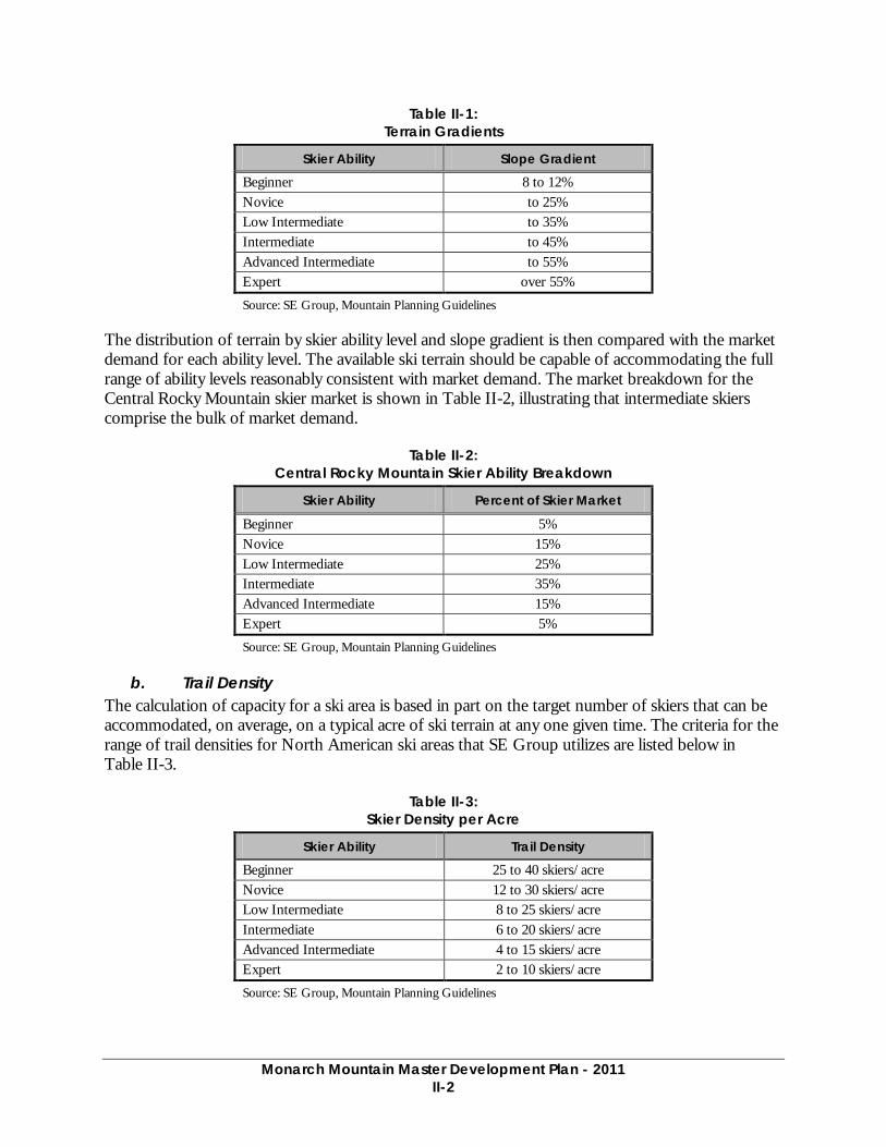
Table II-1: Terrain Gradients
Skier Ability Slope Gradient
Beginner 8 to 12% Novice to 25% Low Intermediate to 35% Intermediate to 45% Advanced Intermediate to 55% Expert over 55%
Source: SE Group, Mountain Planning Guidelines
The distribution of terrain by skier ability level and slope gradient is then compared with the market demand for each ability level. The available ski terrain should be capable of accommodating the full range of ability levels reasonably consistent with market demand. The market breakdown for the Central Rocky Mountain skier market is shown in Table II-2, illustrating that intermediate skiers comprise the bulk of market demand.
Table II-2: Central Rocky Mountain Skier Ability Breakdown
Skier Ability Percent of Skier Market
Beginner 5% Novice 15% Low Intermediate 25% Intermediate 35% Advanced Intermediate 15% Expert 5%
Source: SE Group, Mountain Planning Guidelines
b. Trail Density The calculation of capacity for a ski area is based in part on the target number of skiers that can be accommodated, on average, on a typical acre of ski terrain at any one given time. The criteria for the range of trail densities for North American ski areas that SE Group utilizes are listed below in Table II-3.
Table II-3: Skier Density per Acre
Skier Ability Trail Density
Beginner 25 to 40 skiers/acre Novice 12 to 30 skiers/acre Low Intermediate 8 to 25 skiers/acre Intermediate 6 to 20 skiers/acre Advanced Intermediate 4 to 15 skiers/acre Expert 2 to 10 skiers/acre
Source: SE Group, Mountain Planning Guidelines
Monarch Mountain Master Development Plan - 2011
II-3
These density figures account for the skiers that are actually populating the ski trails and do not account for other guests who are either waiting in lift lines, riding the lifts, using the milling areas or other support facilities. Through observations and calculations, SE Group has determined that on an average day, approximately 33% of the total number of skiers in the area will be on the trails at any one time. Additionally, areas on the mountain, such as merge zones, convergence areas, lift milling areas, major circulation routes, and egress routes, will experience higher densities periodically during the ski day.
SE Group has seen a recent trend in trail density design criteria that provides for less crowded skiing experiences. As witnessed at many Colorado resorts, there is a segment of the market that has a preference for more natural, unstructured, semi-backcountry types of terrain commonly referred to as off-piste.6 Open bowls, glades, and other similar types of terrain are increasing in demand. Skier density per acre numbers are not necessarily applicable to these types of terrain, particularly as there often is not a defined edge to these areas like on a traditional ski run. However, skiers are attracted to these areas for the un-crowded feel, and the experience and challenge that it affords. These areas should be provided if possible. Examples range from glading between existing runs to providing guided out-of-bounds tours.
c. Trail System A primary goal for Monarch’s trail system design is to provide a wide variety of ski terrain which caters to the ski area’s guest demographic. Each trail should provide an interesting and challenging experience for skiers with the ability level the trail is designed for. Optimum trail widths should vary depending upon topographic conditions and the caliber of the skier being served. The trail network should provide the full range of ability levels consistent with their market demand.
In terms of a ski area’s ability to retain guests at that ski area, both for longer durations of visitation and for repeat business, one of the more important factors has proven to be variation in terrain. This means having developed runs for all ability levels: some groomed on a regular basis and some not, bowl skiing, tree skiing, off-piste style skiing, and terrain parks and pipes.
In summary, a broad range of skiing terrain satisfies skiers from beginner through expert ability levels within the natural topographic characteristics of the ski area.
d. Terrain Parks Providing a progression in terrain parks, from beginner through expert, is a primary goal. Teaching parks should be provided. Cross traffic should be minimized with good visibility provided in merge zones. Park features should flow easily from one to another and avoid creating bottle necks and traffic jams. Novice parks and features should be separated from the more advanced parks, and should be geared toward a learning environment. A low pressure venue should be provided for beginners, to allow them to be comfortable as they practice tricks and become accustomed to transitions and jumps. Signage should be clear and delineate the difficulty of the various parks and features. This will help ensure that users will be directed to the feature size most appropriate to their ability. Maintenance of the park is critical to ensure quality and the reputation of the park with park enthusiasts. Quality and diversity of features over quantity should be a goal. As the locations of
6 As stated in Chapter I, “Piste” is a term commonly borrowed from French vernacular which refers to a groomed, maintained, defined ski trail. “Off-Piste” therefore refers to the ungroomed, less defined natural style of skiing commonly found in high Alpine areas and bowls.
Monarch Mountain Master Development Plan - 2011
II-4
features, particularly pipes, become fixed, constructing them out of earth can greatly reduce the amount of snow coverage required.
2. Lift Design The goal for lift design is to serve the available ski terrain in an efficient manner, while being sensitive to environmental considerations. A myriad of factors should be considered including wind conditions, visual impacts, wetlands, round-trip skiing, access needs, inter-connectability between other lifts and trails, and the need for circulation space at the lower and upper terminal sites. The vertical rise and length of ski lifts for a particular mountain are important measures of overall attractiveness and marketability of a ski area.
3. Capacity Analysis and Design Comfortable Carrying Capacity (CCC) is defined as a level of utilization for the ski area (the number of visitors that can be “comfortably” accommodated at any given time) that provides a pleasant recreational experience, without overburdening the ski area’s infrastructure. It is expected that ski areas will experience peak day visitation up to 25% above their CCC. The accurate estimation of the CCC of a mountain is a complex issue and is the single most important planning criteria for the ski area. Related skier service facilities can be planned, including base lodge seating, mountain restaurant requirements, sanitary facilities, parking, and other skier services with proper identification of the mountain’s true capacity. The CCC figure is based on a combination of the uphill hourly capacity of the lift system, the downhill capacity of the trail system, and the total amount of time spent in the lift waiting line, on the lift itself, and in the downhill descent.
C. BASE AREA DESIGN Particular consideration should be given to the relationship between the base area and the mountain facilities. Upon arrival at the ski area, skiers should be able to move directly from parking, through ticketing or rentals and other essential ski services, to the base of the lifts. Walking distance and vertical differential between the base area facilities and lifts should be minimized in an effort to move skiers directly onto the mountain. Vehicle, pedestrian, and skier circulation should be coordinated to create an organized and pleasant base area environment.
D. BALANCE OF FACILITIES The mountain master planning process emphasizes the importance of balancing recreational facility development. The size of the skier service functions are designed to match the CCC of the mountain. The future development of a ski area should be designed and coordinated to maintain a balance between accommodating skier needs, ski area capacity (lifts and trails), and the supporting equipment and facilities (e.g., grooming machines, day lodge services and facilities, utility infrastructure, access, and parking).
Monarch Mountain Master Development Plan - 2011
II-5
E. APPLICABLE FOREST SERVICE POLICY DIRECTION 1. Pertinent Forest Plan Direction
a. 1984 Land and Resource Management Plan – Pike and San Isabel National Forests
Monarch’s operations carried out on NFS lands within the existing SUP area must comply with the management directions provided in the 1984 Land and Resource Management Plan – Pike and San Isabel National Forest (1984 LRMP). The 1984 LRMP includes 21 Management Areas for different portions of the Forest based on ecological conditions, historic development, and anticipated future conditions.7 Monarch’s existing ski area falls within the Management Area 1B. Management Area 1B proximate to Monarch is 870 acres in size (682 acres of the Monarch SUP is within Management Area 1B), and directs:
“Management emphasis provides for downhill skiing on existing downhill ski sites. Management integrates ski area development and use with other resource management to provide healthy tree stands, vegetative diversity, forage production for wildlife and livestock, and opportunities for non-motorized recreation.”
Portions of the Monarch SUP area is located within Management Area 2B, including the southern extent of the ski area, the base area entrance and exit roads, and the northern extent of the Mirkwood area. Management Area 2B proximate to Monarch is 4,923 acres in size (58 acres of the Monarch SUP is within Management Area 2B), (Note: due to mapping inaccuracies, the SUP area acreages within Management Area 1B and 2B do not total 800 acres, which is the total SUP acreage presented in the Permit) and directs:
“Management emphasis is for rural and roaded-natural recreation opportunities. Motorized and nonmotorized recreation activities such as driving far pleasure, viewing scenery, picnicking, fishing, snowmobiling, and cross-country skiing are possible. Conventional use of highway-type vehicles is provided for in design and construction of facilities. Motorized travel may be prohibited or restricted to designated routes, to protect physical and biological resources.”
b. Management Policies and Direction Downhill skiing is an important component of the recreation opportunities offered by National Forests. The National Recreation Strategy, a result of the 1987 President’s Commission for America’s Outdoors, gives the Forest Service a major role in providing recreation opportunities on National Forests through partnerships such as those with the ski industry.8
In 1984 the LRMP for the Pike and San Isabel National Forests identified six operating ski areas (Ski Cooper, Monarch, Pikes Peak, Geneva Basin, Cuchara Valley Resort, and Conquistador) and that the demand for downhill skiing has been rapidly increasing.9 Notably, only Monarch and Ski Cooper remain in operation. The 1984 LRMP additionally provided supply and demand projections for
7 USDA Forest Service. 1983 as amended in 1991. Land and Resource Management Plan – Pike and San Isabel National Forests; Comanche and Cimarron Grasslands. 8 USDA Forest Service. 1988. National Recreation Strategy. April. 9 As of 2007, the Pikes Peak, Geneva Basin, Cuchara Valley Resort, and Conquistador ski areas have permanently ceased downhill skiing operations. Only Ski Cooper and Monarch operate downhill skiing operations on public lands on the Pike and San Isabel National Forests.
Monarch Mountain Master Development Plan - 2011
II-6
average annual downhill skiing use on the National Forest and anticipated demand to outpace supply by year 2011.10
Existing SUP Area Monarch currently operates under a 40-year term SUP administered by the Pike and San Isabel National Forests, which covers approximately 800 acres of NFS lands (refer to Figure IV-1).
The enabling authorities for the Forest Service are contained in many laws enacted by Congress and in the regulations and administrative directives that implement these laws.11 These authorities allow the Forest Service to provide recreation opportunities to facilitate the use, enjoyment, and appreciation of National Forests.
The Forest Service is authorized to approve certain uses of NFS lands under the terms of SUPs.12 Generally, SUPs for recreational developments are issued and administered for uses that serve the public, promote public health and safety, and provide land stewardship. In accomplishing these objectives, the SUP held by Monarch authorizes the implementation of the following:
“Base Lodge, A-frame, Children’s Ski School and Nursery, Maintenance Building, Ski Lifts and Tows, Ski Trails, Parking Area, Communication System, Log Cabin, Water Supply System, Sewage Treatment Facility, Explosive Storage Buildings, and Ski Patrol Buildings at the following locations: Base Area, Top of Panorama Lift, and Top of Breezeway Lift.”13
Proposed SUP Adjustment and the 1991 Grand Mesa, Uncompaghre, and Gunnison National Forest Plan
The existing 800 acre SUP boundary would increase to 1,144 acres to include a portion of No Name Basin. Therefore, the proposed SUP boundary would occur on the Pike and San Isabel National Forests and the Grand Mesa, Uncompaghre, and Gunnison (GMUG) National Forests. No Name Basin lies on the west side of the Continental Divide, and includes portions that are currently used by the Monarch Snowcat Tours. Approximately 344 acres within No Name Basin are proposed to offer 139 acres of lift-served skiing under this MDP.
No Name Basin crosses National Forest boundaries and lies on lands managed by the GMUG National Forests. Administration of the area was delegated to the Pike and San Isabel National Forest by the GMUG National Forest via a Delegation of Authority on April 22, 2009. Development and recreation use of the area would nevertheless be consistent with directives contained in the existing 1991 GMUG Amended Land and Resource Management Plan (1991 GMUG LRMP). 10 USDA Forest Service. 1983 as amended in 1991. Land and Resource Management Plan – Pike and San Isabel National Forests; Comanche and Cimarron Grasslands. p. II-40 11 These laws include: the Organic Administrative Act (1897), the Weeks Act (1911), the Multiple-Use Sustained Yield Act (1960), the Forest and Rangeland Renewable Resources Planning Act (1974), the National Forest Management Act (1976) and the National Forest Ski Area Permit Act (1986). 12 16 USC 497: Use and Occupation of Lands for Hotels, Resorts, Summer Homes, Stores and Facilities for Industrial, Commercial, Educational or Public Uses. 13 USDA Forest Service. 1983 as amended in 1991. Land and Resource Management Plan – Pike and San Isabel National Forests; Comanche and Cimarron Grasslands. p. III-94; The Sprung Structure was approved in the previous Monarch MDP Environmental Assessment. This documentation did not change the language contained with Monarch’s 40-year term SUP. Numerous other authorized facilities are not included in the SUP language; the slope side bathroom building, weather station, Ski Patrol building at the top of Garfield, fuel storage locations, and three overflow tents.
Monarch Mountain Master Development Plan - 2011
II-7
No Name Basin falls within the 1991 GMUG LRMP’s Management Area 1B. Management Area 1B proximate to Monarch is 5,373 acres in size, and directs:
“Management emphasis provides for downhill skiing on existing sites and maintains selected inventoried sites for future downhill skiing recreation opportunities. Management integrates ski area development and use with other resource management to provide healthy tree stands, vegetative diversity, forage production for wildlife and livestock, and opportunities for non-motorized recreation.”
The No Name Basin portion of the Monarch SUP would include 344 acres within overall 5,373 acre Management Area 1B. Adding additional acreage into Monarch’s SUP boundary would reduce current skier densities on intermediate trails during the busy weekends and holiday periods and enable the Forest Service to accommodate future demand for developed downhill skiing on public lands. This is supported in the current 1991 GMUG LRMP, which recognizes that the demand for downhill skiing will increase in the future. The 1991 GMUG LRMP specifically mentions the No Name Basin area as a candidate for future developed downhill skiing and states:
“Downhill skiing use is expected to reach 1,063,000 RVD’s annually by year 2030. Crested Butte, the Monarch expansion, Powderhorn, and Telluride have potential capacity to supply downhill skiing opportunities to meet projected demand through 2030.”14
2. Recreation Opportunity Spectrum The 1984 LRMP for the Pike and San Isabel National Forests states,
“Approximately 84 percent of the recreation use on the Pike and San Isabel National Forests occur within the Roaded Natural, Rural, and Urban [Recreation Opportunity Spectrum] ROS classes. Almost 100 percent of all developed recreation sites, including ski areas, occur within these classes and account for the resultant intensive use.”15
The Monarch SUP area is designated within the 1984 LRMP to have a ROS setting of “Rural.” This setting is described in the Forest Service’s 1986 ROS Book as:
“Predominantly a culturally modified setting where the natural environment has been substantially modified, i.e., structures are readily apparent, pastoral or agricultural or intensively managed, wildland landscapes predominate as viewed from visually sensitive roads and trails. Access is primarily via conventional motorized use on roads. Contact frequency with other users may be moderate to high in developed sites and moderate away from developed sites.”
Additionally, the 1991 GMUG LRMP identifies Management Area 1B to have a ROS setting of “Semi-primitive” (non-motorized) and states,
“Management integrates ski area development and use with other resource management to provide…opportunities for non-motorized recreation.”16
14 Ibid. p. II-23 15 Ibid. p.II-23 16 Ibid. p. III-92
Monarch Mountain Master Development Plan - 2011
II-8
This setting is described in the Forest Service’s 1986 ROS Book as:
“A setting that has an area of primitive roads* or trails that are not open to motorized use; is generally at least 2,500 acres in size; and is between 1/2 and 3 miles from all roads, railroads, or trails with motorized use. Access is via non-motorized trails or non-motorized primitive roads or cross-country. Low contact frequency with other visitors. High probability of solitude; natural-appearing environment. Note: “Primitive roads” are not constructed or maintained and are not generally suitable for highway type vehicles.”
The assigned desired ROS condition class is the maximum level of use, impact, development, and management that an area should experience over the life of the Forest Plan. The ROS is not prescriptive; it serves as a tool for land managers to identify and mitigate change. Recreational carrying capacity is a consequence of adopting specific ROS classes for which a landscape will be managed.
3. Scenery Management a. Visual Management System
In addition to providing recreation experiences and the production of numerous resources, public landscapes provide beauty, which is a valuable resource to many Forest Service constituencies. This resource is explicitly recognized by law. The National Environmental Policy Act (NEPA) requires equal consideration of aesthetics and science. Since the mid-1970s, the Forest Service has utilized the Visual Management System (VMS) to measure the inherent scenic quality of any forest area as a measurement of the degree of alteration for use in inventory and management.17 Although the Forest Service has since replaced the VMS with a new management direction for visual resources to be included in subsequent Forest Plan revisions, the VMS continues to provide direction for the Pike and San Isabel National Forests under the 1984 LRMP and the GMUG National Forests under the amended 1991 LRMP, for managing the aesthetic environment.
As such, the LRMPs for these respective Forests establish acceptable limits of change for Scenic Resources.18 The acceptable limits of change are the documented Visual Quality Objectives (VQO), which serve as a management goal for scenic resources.
Visual Quality Objectives A project can cause visual resource change that can be objectively measured. Viewer response to this change, although subjective, usually displays broad patterns of consensus. Thus, visual impacts comprise both the landscape change and viewer response to that change. By assessing the existing visual character of an area in terms of pattern elements (form, line, color and texture) and pattern character (dominance, scale, diversity, and continuity), it is possible to identify the extent to which the visual character of a facility will exhibit visual contrast with the landscape, or it’s converse, visual compatibility.
VQOs as defined within the VMS, are based on the physical characteristics of the land and the sensitivity of the landscape setting as viewed by humans. VQOs define how the landscape will be 17 USDA Forest Service. 1974. National Forest Landscape management, Volume 2, Chapter 1, The Visual Management System. 18 USDA Forest Service. 1983 as amended in 1991. Land and Resource Management Plan – Pike and San Isabel National Forests; Comanche and Cimarron Grasslands.

Monarch Mountain Master Development Plan - 2011
II-9
managed; the level of acceptable modification permitted in the area, and under what circumstances modification may be allowed. VQOs range from Preservation (untouched environment) to Maximum Modification (major disturbance). Per the 1984 LRMP and the Amended 1991 GMUG LRMP, the Monarch SUP area and No Name Basin area are classified as a VQO of Modification. The VMS provides the following definition of the Modification VQO:
“Results of management activities may visually dominate the original characteristic landscape. However activities of vegetative and land form alteration must borrow from naturally established form, line, color, or texture so completely and at such a scale that its visual characteristics are those of natural occurrences within the surrounding area or character type.”
b. Built Environment Image Guide In concept, the Built Environment Image Guide (BEIG) is designed to ensure thoughtful design and management of the built environment, which includes: administrative and recreation structures, landscape structures, site furnishing, structures on roads and trails, and signs installed or operated by the Forest Service, its cooperators, and its permittees. It focuses on the image, appearance, and structural character of facilities. Three core contexts are stressed throughout the BEIG: (1) environmental; (2) cultural; and (3) economic.
The BEIG provides general guidance regarding the image, aesthetics, and overall quality of recreational and administrative structures on NFS lands, but it does not contain enforceable “standards” pertaining to aesthetic quality as would be found in a typical Forest Plan. As indicated on pages 250–252 of the BEIG, specific direction for the design of administrative and recreational facilities is found in the Forest Service Manual (FSM) and Forest Service Handbooks (FSH).
The environmental, cultural, and economic contexts with which the BEIG is based are important considerations in development of structural facilities (not including lift terminals) within the Monarch SUP area. Furthermore, there are some elements of the BEIG within the “Rocky Mountain Province” section (pages 159–178) that should be taken into account when designing and constructing facilities on NFS lands.
4. Accessibility to Public Lands In June 2005, the Forest Service released the Accessibility Guidebook for Ski Areas Operating on Public Lands, 2005 Update. This guidebook provides information for ski areas authorized under a SUP to work with the Forest Service in providing equal opportunities for all people, including those with disabilities. Monarch will ensure consistency with this guidebook for future development projects occurring on public lands.
Ski areas operating under special-use authorization from the Forest Service are required to comply with both the Americans with Disabilities Act of 1990 (ADA) and Section 504 of the Rehabilitation Act of 1973 (Section 504). The ADA applies because Monarch operates as a “public accommodation;” moreover, Monarch is a business open to the public. Section 504 applies because Monarch operates under a SUP authorized by the Forest Service. Through the SUP, the ski area agrees to abide by these and all other laws, regulations, and policies of the federal government.
Significant legislation that preceded the ADA included the Architectural Barriers Act (ABA) of 1968 and the Rehabilitation Act of 1973, as amended. ABA was the first measure passed by Congress to

Monarch Mountain Master Development Plan - 2011
II-10
ensure access to facilities. The ABA requires that all facilities built, bought, or leased by a Federal agency be accessible. Section 504 of the Rehabilitation Act states: “No otherwise qualified individual with a disability in the United States shall, solely by reason of his disability, be excluded from participation in, be denied the benefits of, or be subjected to discrimination under any program or activity receiving Federal financial assistance or under any program or activity conducted by any Executive Agency.”
Monarch currently complies with this legislation through their active involvement in assisting disabled guests with skiing and other recreation activities. Through future site-specific NEPA and design development reviews, Monarch will work closely with the Forest Service to ensure accessibility measures are taken to provide equal opportunity to all users of public lands.
Chapter 3 Site Inventory

Monarch Mountain Master Development Plan - 2011
III-1
III. SITE INVENTORY
A. PHYSICAL RESOURCES
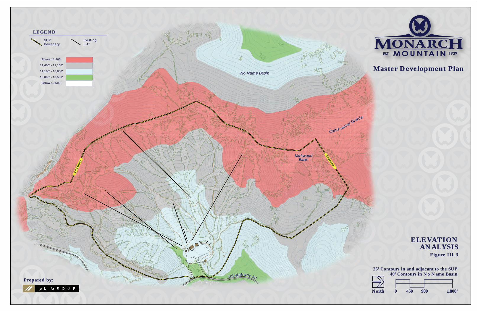
1. Topography Monarch’s base lodge and parking lot are located at an approximate elevation of 10,825 feet above sea level. The highest lift-accessible point (via the Panorama lift) is approximately 11,800 feet above sea level, while the “hike to” terrain in Mirkwood Basin tops out at 11,942 feet above sea level (refer to Figure III-3). Therefore, the vertical rise at Monarch is approximately 1,110 feet. The steepest slopes on the mountain are located in Mirkwood Basin. The steepest lift served terrain is generally above the 11,250-foot contour and is accessed by the Panorama and Garfield lifts. Slopes are generally uniform, with the steepest areas near the top and lowest grades at the bottom.
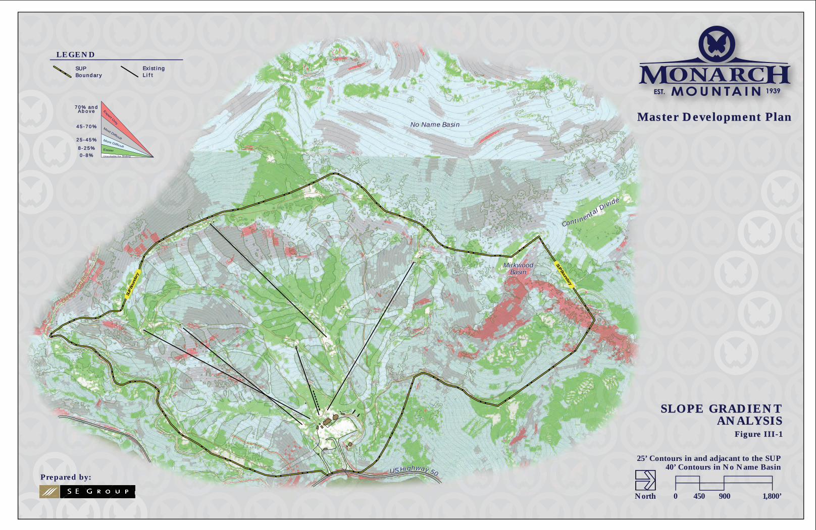
2. Slope Gradients The Slope Gradient Analysis for the study area is shown in Figure III-1. The full range of skiable gradients has been color coded, in order to depict the primary skill classifications for skiers. The color designations are described below:
• White: slope gradients between 0 and 8% (0 to 5 degrees) are too flat for skiing, but ideal for base area accommodations, and other support facility development
• Green: slope gradients between 8 and 25% (5 to 15 degrees) are ideal for beginner to novice skiers, and typically can support some types of development
• Blue: slope gradients between 25 and 45% (15 to 25 degrees) are ideal for intermediate skiers, and typically are too steep for development
• Grey: slope gradients between 45 and 70% (25 to 35 degrees) are ideal for expert skiers, and pose intermittent avalanche hazards
• Red: slope gradients greater than 70% (40 degrees and over) are gradients too steep for all but the highest level of skiing. Areas of this high slope are typically allocated as expert only and are closely managed by the ski area operator
Overall, the slope analysis shows a good mix of ability level designations. As demonstrated in Figure III-1, the middle and lower portions of the SUP provide a variety of easy to low-intermediate terrain with a sufficient amount of slope gradients between 8 to 25% to access the base area. Intermediate terrain, with slope gradients between 26 to 45%, can be found throughout the SUP area and can be accessed by all of Monarch’s chairlifts. A limited amount of advanced terrain with slope gradients between 45 to 70% is available within the SUP area. Expert terrain with gradients 70% and above are limited and primarily found within Mirkwood Basin.
A slope analysis performed for terrain within No Name Basin (proposed for lift-served skiing) indicates that the area would primarily cater to the intermediate, advanced-intermediate ability levels. Some proposed gladed terrain could be signed as expert ability level due to the skill set required to navigate through trees. In addition, as demonstrated in Figure III-1, the high alpine terrain on the northern extent of No Name Basin includes terrain with slope gradients between 46 to 70%, which attracts guests of advanced and expert ability levels. Additional advanced to expert terrain can be
Monarch Mountain Master Development Plan - 2011
III-2
found in other “pockets” of No Name Basin. The majority of terrain primarily has a slope gradient between 26 to 45%, which caters to the intermediate ability level.
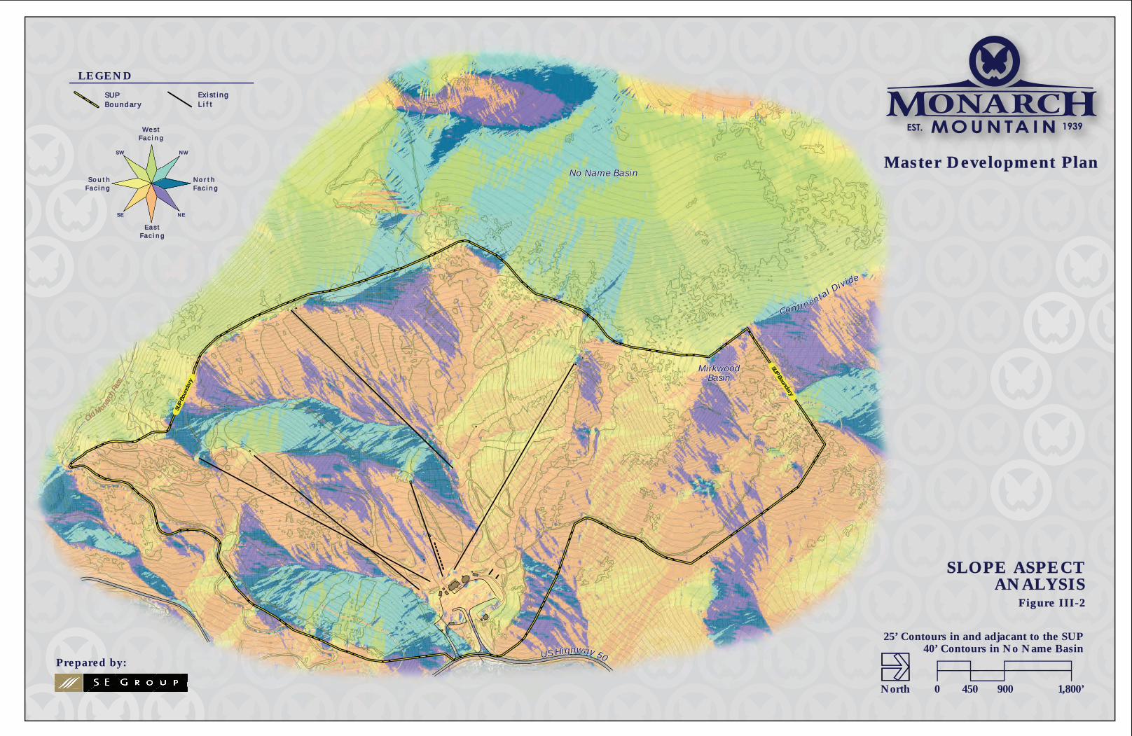
3. Slope Aspect The existing Monarch SUP area is located in a large bowl below a long ridge line with a few protruding sub ridges. Individual portions of developed runs have exposures to every aspect, but the majority of terrain has northeast, east and southeast facing aspects (refer to Figure III-2). Slope aspect plays an important role in snow quality and retention at this latitude. The variety of exposures present opportunities to provide a range of slope aspects that can respond to the changes in sun angle. The various angles of exposure are discussed below.
Similar to the Slope Gradient Analysis, a Slope Aspect Analysis was completed for the terrain within No Name Basin (refer to Figure III-2). This area is located on the western ridge of the Continental Divide. As such, terrain within No Name Basin have general exposures to the northwest, west, and southwest. In addition to slope aspect, the high altitude nature of the area would also ensure consistent quality snow conditions. The various angles of sun exposure are discussed below:
• North-facing: ideal for snow retention, minimal wind scour, minimal sun exposure
• Northeast-facing: ideal for snow retention, minimal wind scour, minimal sun exposure
• East-facing: good for snow retention, some wind scour, morning sun exposure
• Southeast-facing: fair for snow retention, moderate wind scour, morning and early afternoon sun exposure
• South-facing: poor for snow retention, moderate wind scour, full sun exposure
• Southwest-facing: poor for snow retention, high wind scour, full sun exposure
• West-facing: fair for snow retention, high wind scour, late morning and afternoon sun exposure
• Northwest-facing: good for snow retention, high wind scour, afternoon sun exposure
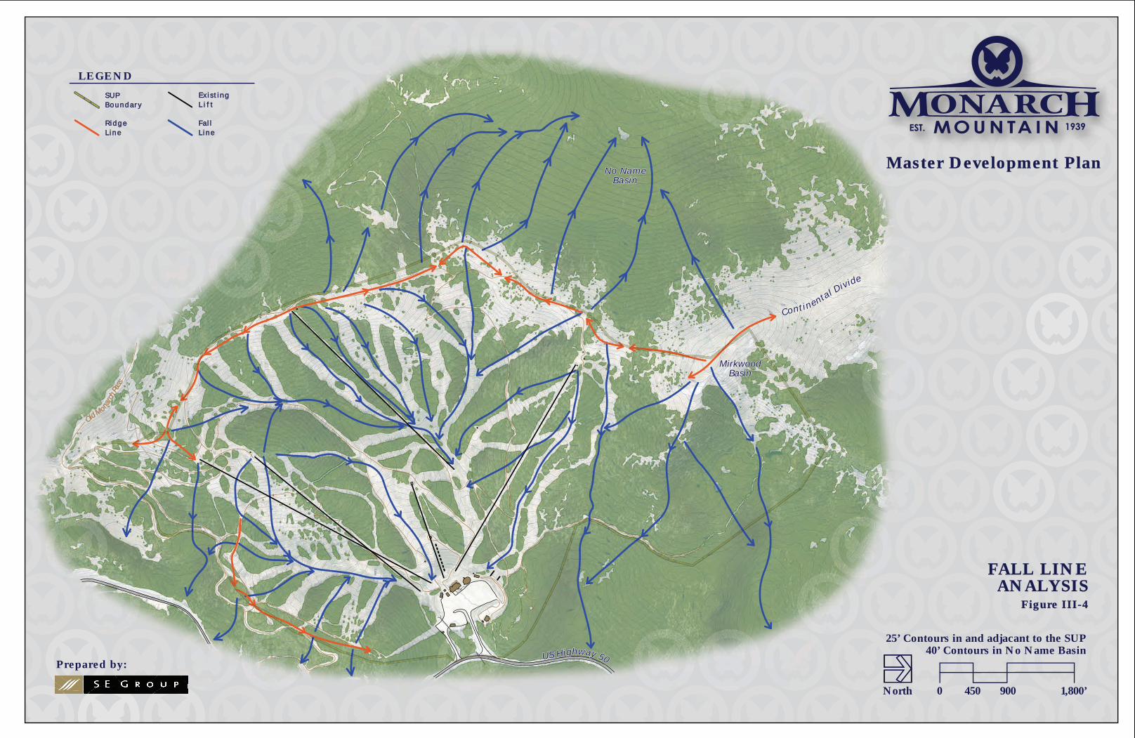
4. Fall Line The Fall Line Analysis evaluates the natural fall lines of mountainous terrain, with the fall line representing the path an object would take as it descends a slope under the influence of gravity. Fall line paths indicate the natural flow of potential ski trail routes, from the top of mountain ridges to the valleys and base areas below. Consistency of fall line provides for the best recreational skiing experience and results in the least amount of environmental disruption due to the minimal amount of terrain modification required for trail construction.
As shown in Figure III-4, the terrain within No Name Basin is characterized by long, consistent fall lines that cover the majority of the area. These features indicate the potential to develop a well-integrated and efficient trail system that would be enjoyable to ski and cause minimal topographic disturbance for construction.

Monarch Mountain Master Development Plan - 2011
III-3
B. PERMIT BOUNDARY AND LAND OWNERSHIP
1. Existing SUP Monarch operates on 800 acres of NFS land under a 40-year term SUP authorization from the Pike and San Isabel National Forests (refer to Figure IV-1). The 1984 LRMP designates the Monarch SUP under Management Area 1B-1 (Existing Winter Sports Sites). See Chapter II for a description of Management Area 1B-1. Additionally, Monarch operates its snowcat tours on approximately 900 acres of adjacent NFS lands located north of the developed ski area under an annually renewable Forest Service Outfitter and Guide Permit. Since the snowcat tours operation is administered under a separate Forest Service Permit, this MDP does not include further discussion on the snowcat operation.
Existing skiing terrain encompasses 58 trails on approximately 270 acres of lift-served terrain, as well as an additional 141 acres of managed hike-to terrain, with a vertical drop of 1,110 feet. Monarch’s bowls, glades, and trails provide a wide variety of skiing, with approximately 38 acres (14%) of the trail capacity distribution classified as novice, 52 acres (19%) as low intermediate, 58 acres (21%) as intermediate, 76 acres (28%) as advanced intermediate, and 44 acres (16%) classified as expert; these numbers include only lift-served skiing and not hike-to terrain or terrain offered by snowcat tours (due to rounding, these do not total 100%).19
2. Proposed SUP Adjustment Refer to Chapter VI for a discussion of a SUP boundary adjustment that would be required for the development of No Name Basin as lift-served skiing.
C. ENVIRONMENTAL RECONNAISSANCE In developing the proposed design for the No Name Basin terrain, an environmental review team has preliminarily surveyed the area for wetland, wildlife and cultural considerations. The initial design of the No Name Basin pod (refer to Figure VI-1) has taken this information into consideration to ensure that resource parameters and ski terrain function were integrated in the proposed design.
19 It should be noted that Monarch provides approximately 0.2 acre dedicated to beginner terrain located in the Safari teaching area.
OOld Monarc
h Pas
s
SUP Boundary
SUP
Boun
dary
U S H i ghway 50
Con t i n e ntal Div ide
MirkwoodMirkwoodBasinBasin
N o N a m e B a s i nN o N a m e B a s i n
U S H i ghway 50
Con t i n e ntal Div ide
MirkwoodBasin
N o N a m e B a s i n
SLOPE GRADIENTSLOPE GRADIENTANALYSISANALYSIS
Figure III-1Figure III-1
LEGEND
E x i s t i n gE x i s t i n gL i f tL i f t
S U PS U PB o u n d a r yB o u n d a r y
0 450 900 1,800’
25’ Contours in and adjacant to the SUP40’ Contours in No Name Basin
North
Master Development PlanMaster Development Plan7 0 % a n d7 0 % a n d
A b o v eA b o v e
4 5 - 7 0 %4 5 - 7 0 %
2 5 - 4 5 %2 5 - 4 5 %
8 - 2 5 %8 - 2 5 %
0 - 8 %0 - 8 %
Prepared by:
OOld Monarc
h Pas
s
SUP Boundary
SUP
Boun
dary
U S H i ghway 50
Con t i n e ntal Div ide
MirkwoodMirkwoodBasinBasin
N o N a m e B a s i nN o N a m e B a s i n
U S H i ghway 50
Con t i n e ntal Div ide
MirkwoodBasin
N o N a m e B a s i n
SLOPE ASPECTSLOPE ASPECTANALYSISANALYSIS
Figure III-2Figure III-2
N o r t hN o r t hF a c i n gF a c i n g
S o u t hS o u t hF a c i n gF a c i n g
E a s tE a s tF a c i n gF a c i n g
W e s tW e s tF a c i n gF a c i n g
N WN W
N EN E
S WS W
S ES E
LEGEND
Ex i s t ingEx i s t ingL i f tL i f t
SUPSUPBoundar yBoundar y
0 450 900 1,800’
25’ Contours in and adjacant to the SUP40’ Contours in No Name Basin
North
Master Development PlanMaster Development Plan
Prepared by:
OOld Monarc
h Pas
s
SUP Boundary
SUP
Boun
dary
U S H i ghway 50
Con t i n e ntal Div ide
MirkwoodMirkwoodBasinBasin
N o N a m e B a s i nN o N a m e B a s i n
U S H i ghway 50
Con t i n e ntal Div ide
MirkwoodMirkwoodBasinBasin
N o N a m e B a s i nN o N a m e B a s i n
ELEVATIONELEVATIONANALYSISANALYSIS
Figure III-3Figure III-3
LEGEND
E x i s t i n gE x i s t i n gL i f tL i f t
S U PS U PB o u n d a r yB o u n d a r y
0 450 900 1,800’
25’ Contours in and adjacant to the SUP40’ Contours in No Name Basin
North
Below 10,500’Below 10,500’
10,800’ - 10 ,500’10,800’ - 10 ,500’
11,100’ - 10 ,800’11,100’ - 10 ,800’
11,400’ - 11 ,100’11,400’ - 11 ,100’
Above 11,400’Above 11,400’
Prepared by:
Master Development PlanMaster Development Plan
OOld Monarc
h Pas
s
MirkwoodMirkwoodBasinBasin
U S H i ghway 50
Con t i n e ntal Div ide
N o N a m eN o N a m eB a s i nB a s i n
MirkwoodBasin
U S H i ghway 50
Con t i n e ntal Div ide
N o N a m eB a s i n
0 450 900 1,800’
25’ Contours in and adjacant to the SUP40’ Contours in No Name Basin
North
LEGEND
Ex i s t ingEx i s t ingL i f tL i f t
SUPSUPBoundar yBoundar y
FALL LINEFALL LINEANALYSISANALYSIS
Figure III-4Figure III-4
Fa l lFa l lL ineL ine
R idgeR idgeL ineL ine
Prepared by:
Master Development PlanMaster Development Plan
Chapter 4 Existing Facilities
Inventory & Analysis

Monarch Mountain Master Development Plan - 2011
IV-1
IV. EXISTING FACILITIES INVENTORY AND ANALYSIS
The following section contains an examination and analysis of existing skier facilities at Monarch. Completion of a thorough resort inventory is the first step in the master planning process and involves the collection of data pertaining to Monarch’s existing facilities. This inventory includes ski lifts, ski trails, base area structures, skier services, and day-use parking area. The analysis of the inventoried data involves the application of ski industry standards to Monarch’s existing conditions. This process allows for the comparison of Monarch’s existing ski facilities to those facilities commonly found at comparison ski areas of similar size and composition.
The overall balance of the existing ski area is evaluated by calculating the skier capacities of various facility components and then comparing these capacities to the ski area’s current CCC. This capacity examination helps identify Monarch’s strengths and deficiencies. The next step is the identification of improvements that would bring the existing facilities into better equilibrium, and assist the ski area in meeting the ever-changing expectations of their skier marketplace. Accomplishing these objectives will result in a well-balanced ski area that provides an adequate array of services and experiences to satisfy guest expectations for an excellent recreation experience.
A. SUMMARY OF GUEST EXPERIENCE Determining the ski area’s CCC is an important first step because it enables planners to understand the overall balance of the ski area. Personal observation and close examination of Monarch’s principal components reveal some key surpluses and deficiencies.
Monarch’s daily lift capacity is determined by analyzing the ski area’s supply of, and demand for, vertical transport. The capacity of the lift network was determined to be approximately 2,870 guests (refer to Table 5 in Appendix A for a detailed lift calculation). The planning analysis recognizes limitations and constraints with regards to space and seating at Monarch’s base area guest service facilities. This deficit may directly influence guests’ enjoyment and comfort at the ski area. In addition, the slight shortage of rental/repair space may be a deterrent for beginners who are typically the majority of rental customers.
The remainder of this chapter briefly describes the qualitative nature of Monarch’s guest facilities, as well as Monarch’s other ancillary operations (e.g., ski patrol, first aid, maintenance, etc.) and ski area infrastructure. Monarch’s existing facilities are discussed below.
B. ALPINE FACILITIES (LIFTS AND TERRAIN)
1. Lifts Monarch’s lift network currently consists five aerial chairlifts and two surface conveyor lifts. These lifts include the following:
• Fixed-grip Quad Chair: (Pioneer)
• Fixed-grip Double Chairlifts: (Garfield, Breezeway, Panorama, and Tumbelina)
Monarch Mountain Master Development Plan - 2011
IV-2
• Conveyor Lifts: (Safari and Congo)20
• Total Uphill Chairlift Design Capacity per Hour: 7,300 guests
All chairlifts and surface lifts are located entirely on NFS lands. Monarch’s existing lifts service the terrain efficiently except for some hard to reach areas, such as the trails from North Forty through Gunbarrel northeast of the top terminal of Pioneer lift and the hike-to terrain in Mirkwood Basin.
The Breezeway lift serves intermediate, advanced-intermediate, and expert terrain in the northern portion of the ski area and provides Monarch’s guests with access to the staging area for the Monarch Snowcat Tours. Breezeway also provides access to the K2 Terrain Park. The terrain serviced by the Breezeway lift features the mountain’s longest intermediate runs and has relatively short lift lines. The popularity of Breezeway’s terrain is enhanced by machine grooming efforts and long periods of sun on spring days. However, due to Breezeway pod’s southern exposure, the snow surface tends to freeze due to spring conditions.
The bottom terminal of the Breezeway lift is located on a 10-foot earthen platform which adds to the amount of vertical that a guest has to traverse from the parking lots to the Breezeway lift. This steep traverse is difficult for many of Monarch’s guests that come from lower elevations or are unfamiliar with walking in ski boots. The bottom terminal also adds to the congestion of the base area because of its close proximity to the base area facilities.
The Garfield and Pioneer lifts service a wide variety of terrain in the southern portion of the ski area, from the challenging Gunbarrel trail to the widely utilized Sleepy Hollow trail. These lifts provide access to approximately 80% of Monarch’s novice terrain. The Pioneer lift was installed in 1999 to provide additional out of base capacity and take pressure off the Garfield double chair, which was installed in 1969.21
The Panorama lift (fixed-grip double) is Monarch’s only up mountain lift that cannot be accessed directly from the base area. The Panorama lift serves the predominately advanced-intermediate and expert terrain situated in the central portion of the ski area. In addition to satisfying the desires of Monarch’s advanced skiers and snowboarders, the Panorama lift also serves novice to intermediate ability level guests that choose to ride the lift primarily for the spectacular vistas afforded by the scenic Continental Divide. Panorama’s Skywalker trail is designed to ensure that the lower ability level guests (except first-time beginners) are able to egress from the lift’s upper terminal to the popular Sleepy Hollow trail, which is rated as a novice ability level trail.
The Tumbelina lift is very popular with guests of the beginner and novice ability levels. Installed in 1981, the Tumbelina lift features a relatively slow rope speed of 350 feet per minute (FPM).22 Guests that ride Tumbelina enjoy novice and low intermediate terrain and easy access to the Panorama lift.
20 An additional conveyor lift is planned to be constructed adjacent to the Tumbelina Chairlift during the 2011 summer construction season. This conveyor lift is shown in the existing condition figures that accompany Chapters 1 through 4, but is not discussed in the existing conditions analysis since it has not operated during any portion of the previous ski season. The detailed specifications of this conveyor lift are discussed in Chapters 5 and 6. 21 The lower drive terminal of the Garfield lift was completely replaced with a new terminal in 2010. 22 The Tumbelina lift is designed for a rope speed of 500 FPM, but running it at 350 FPM provides a better guest experience for the beginner guest.
Monarch Mountain Master Development Plan - 2011
IV-3
As the main beginner lift and terrain, the Tumbelina lift typically endures the highest utilization of any lift on the mountain, especially during peak periods such as weekends and holidays. Lift line wait times for the Tumbelina lift can often exceed 20 minutes, which consequently adds to the congestion within the base area. The majority of the guests on the Tumbelina lift disembark at the mid-station, and a small number of guests continue up to the top terminal. Improved utilization of upper trails access by Tumbelina lift could be achieved through a reconfiguration of teaching terrain and limited use of the mid-unload terminal.
The Safari and Congo lifts are Monarch’s only conveyor lifts and provide access to a small first-time beginner teaching area located on the Safari teaching slope. This area is only utilized by the children’s ski and ride school since it is in a location separate from areas of skier circulation. However, access to the Safari and Congo lifts can become difficult for some small children due to the relatively large distance between the ski school building and Safari and Congo lifts.
The lift specifications in Table 1 in Appendix A provide specific information by individual lift.
2. Alpine Terrain The existing developed trail network is comprised of 56 trails that account for a total of 270 acres of lift-served skiable terrain. An additional 130 acres of managed, hike-to terrain is offered in Mirkwood Basin, which is accessed via the Breezeway lift and a short hike. The maximum vertical drop of the trail network is 1,110 feet—from the top of Mirkwood Basin to the base facilities. An additional 900 acres of off-piste terrain are offered through Monarch Snowcat Tours, which operates under a separate Forest Service Outfitter and Guide Permit. This terrain is located immediately adjacent to Monarch’s existing SUP boundary on the northern and western boundaries. The terrain specifications in Table 3 in Appendix A provide specific information by individual ski trail.
a. Lift-Served Terrain Trail development at Monarch maximizes the potential of the site’s natural terrain features and topographic relief while respecting the mountain’s contours and fall lines. However, some notable challenges are evident in Monarch’s trail design. These include the hiking required to access Tele Alley, Gunbarrel, and North Forty trails after the saddle in the ridge, as well as the narrow and less visible traverse from the top of Garfield that occasionally restricts some use of the northern trail network, including: Examiner, Upper No Name, Lobo, Upper Christmas Tree, and Lower No Name. An additional challenge exists for skier/snowboarders accessing the base area from Lower Tango due to a significant elevation differential Moreover, the bottom of Lower Tango and the Garfield lift bottom terminal are at a lower elevation compared to the base area facilities and the other out-of-base lifts. Trail widening and improved signage along Lower Tango would allow guests to directly access base area facilities without an uncomfortable hike out of the lower elevation.
For the most part, Monarch’s trails have been cleared to widths that allow for a relatively free flow of skiers and snowboarders. However, during periods of peak demand, some of Monarch’s more popular trails experience uncomfortable levels of congestion. Widening of known pressure points, particularly on portions of Sleepy Hollow, Upper Christmas Tree, Lower No Name, and K2, as well as modifications to other trails throughout the ski area, would improve the circulation of Monarch’s terrain, specifically during periods of peak demand.

Monarch Mountain Master Development Plan - 2011
IV-4
Terrain Distribution by Ability Level Monarch’s developed ski trail network accommodates the entire range of skier ability levels, from novice to expert.
Due to the natural topography, Monarch’s terrain distribution by ability level is slightly skewed toward the novice to low-intermediate ability levels (refer to Table IV-1 below). Comprising approximately 39 acres of the maintained trail network, Monarch’s novice terrain is concentrated in the mid-southern portion of the ski area’s SUP boundary. Some of Monarch’s most popular trails, Sleepy Hollow, Glade, Lower Tango, and Skywalker are within the ability of guests with novice skills.
Approximately 52 acres of Monarch’s terrain dedicated to the low-intermediate ability level, which can be found in the southern half of the ski area. The Garfield and Pioneer lifts provide conveyance to some very attractive, low-intermediate terrain, including the following trails: Freeway, North Forty, and Tele Alley.
Due to the disproportionate amount of novice and low-intermediate terrain, Monarch’s intermediate skiers and snowboarders are largely limited to the terrain serviced by the Breezeway lift and a few small areas off the Panorama lift. Comprising approximately 59 acres of Monarch’s terrain, some popular intermediate trails include Little Mo, K2, Lower No Name, Turbo, and Snowburn.
Monarch’s advanced-intermediate and expert terrain comprise approximately 76 acres and 45 acres, respectively. The trails served by the Panorama lift are categorized as advanced-intermediate and expert terrain (e.g., Mirage, Sheer-Rock-O, High Anxiety, Frazzle, Zipper, Dire Straits, and Picante). Similar terrain is also available to Monarch guests that choose to ski and snowboard the Breezeway and Garfield terrain pods.
Monarch’s distribution of terrain by ability level is provided in Table IV-1 and Chart IV-1. The far right column in Table IV-1 represents the estimated ski level distribution of Monarch’s targeted markets. Table IV-1 and Chart IV-1 demonstrate how Monarch’s terrain distribution compares with the estimated skill level distribution of Monarch’s clientele.
Table IV-1: Terrain Distribution by Ability Level – Existing Conditions
Skier/Rider Ability Level
Trail Area
Skier/Rider Capacity
Monarch Skier/Rider Distribution
Monarch Skier/Rider
Market
(acres) (guests) (%) (%)
Beginner 0.6 18.3 1 5 Novice 37.9 682.4 25 15 Low Intermediate 52.0 728.6 27 25 Intermediate 58.6 586.1 22 35 Adv. Intermediate 76.4 535.0 20 15 Expert 44.6 133.8 5 5
TOTAL 270.2 2,684 100 100

Monarch Mountain Master Development Plan - 2011
IV-5
Chart IV-1: Terrain Distribution by Ability Level – Existing Conditions
The terrain distribution table and chart indicate a shortage of Beginner and Intermediate terrain, and a surplus of Novice, Low-Intermediate and Advanced-Intermediate terrain as compared to the ski industry rider market. To remain competitive in an evolving marketplace, Monarch must provide a distribution of terrain capacity to meet the needs and expectations of guests across the spectrum of ability levels. The primary need is for additional intermediate ability level terrain.
b. Managed Hike-To Terrain In addition to the developed trail network, Monarch maintains approximately 130 acres of managed, hike-to terrain in Mirkwood Basin. This terrain is accessed from the Breezeway lift and a short (approximately 12 to 15 minutes) hike along a groomed cat-track (this route also serves as access to snowcat skiing addressed below). Mirkwood Basin offers guests approximately 1,110 vertical feet of advanced and expert terrain. Due to minimal vegetation removal and development, Mirkwood Basin provides guests of an advanced ability level with a unique “off-piste” recreation experience not found anywhere else on the mountain. Monarch actively manages the hike-to terrain by providing regular ski patrol services and snow stabilization measures.
3. Terrain Parks Terrain parks have become a vital part of most ski area’s operations, and are now considered an essential mountain amenity. Popularity of terrain parks continue to increase, and is dependent on the regional location of the ski area, demographics of the ski area’s target guests, and most importantly, the quality of the parks. In past decades, much of the increase in ski area visitation is a result from the emergence of snowboarding, with the development and evolution of terrain parks following. The presence of terrain parks at ski areas changed various operational and design elements. The
0%
5%
10%
15%
20%
25%
30%
35%
40%
Beginner Novice Low Intermediate
Intermediate Adv. Intermediate
Expert
Perc
ent o
f Ski
ers/
Rid
ers
Skier/Rider Ability Level
Existing Skier/Rider Distribution Skier/Rider Market
Monarch Mountain Master Development Plan - 2011
IV-6
demand for grooming can increase, as terrain parks often require specialized or dedicated operators, grooming machines, and equipment (such as half-pipe cutting tools). Terrain parks typically require significant quantities of snow, either natural or machine produced, often increasing snowmaking demands. Terrain parks can affect circulation on the mountain, as the parks are often a guest destination. Many resorts have either installed terrain park specific lifts, or locate their parks in areas that can easily be repeatedly skied using adjacent lifts. As animation is a significant attraction for the youth market, half pipes and terrain parks often have music, flags, and other items as part of the animation.
Terrain park operations at Monarch for the 2011-12 season will take place in two locations; the Tilt beginner park on Lower Glade and along the entire length of K2. Previously, three terrain parks were maintained on Freeway, Lower Glade, and K2. These small parks were comprised of features such as multiple quarterpipes and rollers, log slides, table top jumps, rails, and boxes. Monarch will continue to maintain the beginner park on Lower Glade (as the grades are appropriate for beginners), but will move the Aftershock park from Freeway to K2. Consolidating these parks on K2 will improve the efficiency of the terrain park operations, but also create an exciting and dynamic environment for the terrain park users from intermediate to advanced ability levels. The terrain parks at Monarch have smaller features since the ski area currently does not have a snowmaking system to support large terrain features. Monarch makes up for the lack of snow by constructing features with more rails and boxes for guests to enjoy.
C. COMFORTABLE CARRYING CAPACITY (CCC) The daily carrying capacity of a ski area is described as the Comfortable Carrying Capacity (CCC). CCC is not indicate a maximum level of visitation, but is rather a planning tool defined as the number of daily visitors a resort can comfortably or efficiently accommodate at one time without overburdening the ski area’s infrastructure. The CCC is derived from the ski area’s supply of vertical transport (the combined uphill hourly capacities of the lifts) and demand for vertical transport (the aggregate number of demanded runs multiplied by the associated vertical rise). The CCC is calculated by dividing vertical supply (VTF/Day) by Vertical Demand.
As stated earlier, the accurate estimation of a ski area’s CCC is an important, complex analysis and is the single most important planning criterion for the ski area. All other related skier service facilities can be planned based on the proper identification of the mountain’s capacity. The detailed calculation of Monarch’s current CCC is described in Table 5 in Appendix A and is calculated at 2,870 guests per day. It is typical for ski areas to experience peak days during which skier visitation exceeds the CCC. However, from a planning perspective, it is not recommended to consistently exceed the CCC due to the resulting decrease in the quality of the recreational experience, and thus the ski area’s market appeal. In the case of Monarch, the CCC of 2,870 is often exceeded during the holiday periods and during weekends after decent snow fall. During these high visitation periods, the ski area’s market appeal may suffer from a degradation of quality as guests experience crowding and longer wait times at lifts and in food service facilities. This degradation of quality and market appeal is anticipated to continue until the ski area’s infrastructure is upgraded and expanded to meet the existing demand.
Monarch Mountain Master Development Plan - 2011
IV-7
D. SKI TRAIL DENSITY ANALYSIS An important aspect of ski area design is the balancing of uphill lift capacity with downhill trail capacity. Trail densities are derived by contrasting the uphill, at-one-time capacity of each lift system (CCC) with the trail acreage associated with each lift pod. At any one time, skiers are dispersed throughout the ski area, while using guest facilities and milling areas, waiting in lift mazes, riding lifts, or enjoying descents. For the trail density analysis, 25% of each lift’s capacity is presumed to be inactive—using guest service facilities or milling areas.
The active skier population can be found in lift lines, on lifts, or on trails. The number of skiers waiting in line at each lift is a function of the uphill hourly capacity of the lift and the assumed length of wait time at each lift. The number of guests on each lift is the product of the number of carriers on the uphill line and the capacity of the lift’s carriers. The remainder of the skier population (the CCC minus the number of guests using guest facilities, milling in areas near the base area, waiting in lift mazes, and actually riding lifts) is assumed to be enjoying downhill descents.
Trail density is calculated for each lift pod by dividing the number of guests on the trails by the amount of trail area that is available within each lift pod. The trail density analysis compares the calculated trail density for each lift pod to the desired trail density for that pod (i.e., the product of the ideal trail density for each ability level and the lift’s trail distribution by ability level).
Monarch’s trail density analysis considers only the acreage associated with the ski area’s lift-served trail network, not including terrain in Mirkwood Basin and terrain accessed via snowcat. The trail density analysis assumes that skiers are spread evenly on each acre of available terrain through the ski area’s entire trail network—an unrealistic assumption. Furthermore, on days Monarch is operating at or above its CCC, the majority of skiers are at or around the intermediate ability level range and skiing on intermediate ability level trails. The congestion on certain trails and high trail densities during certain periods of the ski day are a result of the current deficit of intermediate terrain when compared with Monarch’s skier/rider market (refer to Table IV-1).
Strictly from a mountain planning standpoint, the Tumbelina lift has the highest densities of terrain served by aerial chairlifts in terms of the relative trail densities or the density index, which is the difference in calculated density and the desired density (refer to Table 7 in Appendix A). As attendance nears Monarch’s CCC, the Tumbelina pod becomes more congested. The higher densities (not necessarily “density index”) are due in large part to the terrain ability levels this lift serves (i.e., lower ability level terrain has a higher designed trail density), the egress role associated with the Freeway trail as skiers return to the base area, as well as the ski school function of the terrain that the Tumbelina lift serves. Higher skier densities are acceptable on ski school terrain since instructors provide oversight for the various ski school groups utilizing the same terrain.
Through visual observations made by Monarch staff and guests, high trail densities, primarily on the beginner and low-intermediate trails, do occur during high visitation periods. This can be attributed to the clientele that primarily visits Monarch (beginner to low-intermediate skier), making certain pods at Monarch more popular than others, and as a result, receive a disproportionate concentration of use. For complete detail regarding Monarch’s lift pod densities, refer to Table 7 in Appendix A.

Monarch Mountain Master Development Plan - 2011
IV-8
E. SNOWMAKING COVERAGE Currently, Monarch does not have snowmaking capabilities. However, Monarch management does have snowmaking water rights—0.35 cubic feet per second (cfs) priority #51—from White Ditch #1. Approved via the 1999 Decision Notice, if desired, Monarch management may withdraw water for snowmaking purposes for the period of October 15 through December 1.23 It would be beneficial for Monarch to develop a snowmaking system focused on covering “hot-spots” on the lower half of the resort and areas near the base area. This “hot-spot” system would enable the ski area to provide high quality and consistent snow coverage during the early season, low-snow seasons, and the important holiday periods.
F. GROOMING OPERATIONS Monarch grooms the snow surface of their trails to help ensure a quality trail surface, especially during the early and late stages of the season when climatic and snow conditions are less than optimal. Monarch’s grooming fleet consists of four grooming vehicles, all of which are in good working condition. Monarch reserves two tour snowcats for the Snowcat Tour program.
Monarch’s grooming vehicles are equipped with a variety of grooming implements, such as power tillers, rollers, compactor bars, and powder-makers. These implements help Monarch maximize the utility and efficiency of each grooming vehicle.
Monarch’s grooming crews prepare approximately 130 acres of ski terrain on a regular basis. On average, each vehicle is able to groom approximately 4.3 acres per hour or 43 acres over a 10-hour shift. With a fleet of four vehicles, Monarch’s optimal, nightly grooming capacity is approximately 172 acres of terrain.
G. SKIER SERVICES SPACE AND FOOD SERVICE SEATING
1. Skier Services From a planning perspective, Monarch’s base area staging location is considered a “gateway” facility with three main functions:
• Receiving arriving guests (from a parked car or bus),
• Distributing the skiers onto the mountain’s lift and trail systems, and
• Providing the necessary services for guests at the ski area (tickets, rentals).
The buildings and facilities that accommodate visitor services must be sized and located such that they complement the mountain’s CCC. Monarch’s existing visitor services are located primarily in the Day Lodge structure within the base area. However, daycare operations, ski school administration, lift operations, employee lockers/lounge, first aid and clinic space, and the racing program are housed in buildings spread throughout the base area. Table IV-2 provides a summary of ski area-wide space use and identifies existing deficiencies/surpluses in space square footage by function. From a capacity standpoint, Monarch currently provides a guest services capacity to support 2,730 guests. This total is arrived at by dividing the total existing square footage (37,458) by
23 USDA Forest Service, 1999. Monarch Ski Area Master Development Plan Decision Notice and Finding of No Significant Impact.
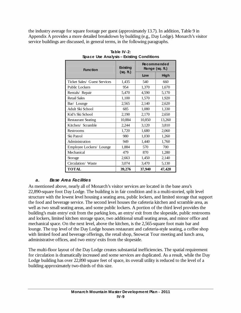
Monarch Mountain Master Development Plan - 2011
IV-9
the industry average for square footage per guest (approximately 13.7). In addition, Table 9 in Appendix A provides a more detailed breakdown by building (e.g., Day Lodge). Monarch’s visitor service buildings are discussed, in general terms, in the following paragraphs.
Table IV-2: Space Use Analysis – Existing Conditions
Function Existing (sq. ft.)
Recommended Range (sq. ft.)
Low High
Ticket Sales/ Guest Services 1,435 540 660 Public Lockers 954 1,370 1,670 Rentals/ Repair 5,470 4,590 5,170 Retail Sales 1,100 1,570 1,920 Bar/ Lounge 2,565 2,140 2,620 Adult Ski School 685 1,080 1,330 Kid’s Ski School 2,190 2,170 2,650 Restaurant Seating 10,884 10,850 13,260 Kitchen/ Scramble 2,244 3,120 3,810 Restrooms 1,720 1,680 2,060 Ski Patrol 980 1,030 1,260 Administration 949 1,440 1,760 Employee Lockers/ Lounge 1,884 570 700 Mechanical 479 870 1,280 Storage 2,663 1,450 2,140 Circulation/ Waste 3,074 3,470 5,130 TOTAL 39,276 37,940 47,420
a. Base Area Facilities As mentioned above, nearly all of Monarch’s visitor services are located in the base area’s 22,890-square foot Day Lodge. The building is in fair condition and is a multi-storied, split level structure with the lowest level housing a seating area, public lockers, and limited storage that support the food and beverage service. The second level houses the cafeteria kitchen and scramble area, as well as two small seating areas, and some public lockers. A portion of the third level provides the building’s main entry/exit from the parking lots, an entry/exit from the slopeside, public restrooms and lockers, limited kitchen storage space, two additional small seating areas, and minor office and mechanical space. On the next level, above the kitchen, is the 2,565-square foot main bar and lounge. The top level of the Day Lodge houses restaurant and cafeteria-style seating, a coffee shop with limited food and beverage offerings, the retail shop, Snowcat Tour meeting and lunch area, administrative offices, and two entry/exits from the slopeside.
The multi-floor layout of the Day Lodge creates substantial inefficiencies. The spatial requirement for circulation is dramatically increased and some services are duplicated. As a result, while the Day Lodge building has over 22,890 square feet of space, its overall utility is reduced to the level of a building approximately two-thirds of this size.
Monarch Mountain Master Development Plan - 2011
IV-10
Located north of the Day Lodge is the Rental and Lesson Center Sprung structure, which was constructed in 2006 and is in excellent condition. The structure is approximately 8,600 square feet in size with its primary function providing rentals/repair services to Monarch’s guests. However, the structure also houses Monarch’s Lesson Center, rental will call, ski school administration offices, and restrooms, as well as required mechanical and circulation space.
An existing retaining wall and staircase located adjacent to the Rental and Lesson Center is in disrepair and will require reconstruction.
The Children’s Center, located north of the Day Lodge, was constructed in 1987, and is in good condition. The approximately 2,600 square foot facility houses play spaces for the daycare, and young children’s ski programs on its main floor and employee lockers in the basement floor. A 750 square foot yurt housing ski school programs for 7-10 year olds sits adjacent to the Children’s Center. Unfortunately, these buildings are a considerable distance from a lift—a factor that limits the utility of the Safari slope and hampers Monarch’s ability to provide the best possible service to the family market. The Children’s Center’s distance from the Day Lodge which houses the Ski School Sales Desk and related guest services (e.g., administration, restrooms, etc.) also results in duplicated spaces and general inefficiencies, which substantially compromises its utility.
The Ski Patrol Building was constructed in 1986, and is in good condition. This facility is located southeast of the Day Lodge with on-grade access to both the trails and parking lot. The 1,492-square foot, single-level structure is dedicated entirely to ski patrol functions. The building is comprised of clinic space, administrative space, patrol locker room, patrol/clinic restrooms, space for patrol radio dispatch, and an office for the Monarch Snowcat Tours.
The 1,300-square foot Tent Deck, adjacent to the Day Lodge, was relocated to its current location in 2006 and is in fair condition. This facility is used to accommodate large groups. While it has seating, there are no attached services that relate to the seating, such as food service and restrooms. As a result, the space within the Tent Deck has only marginal utility and is mostly used by guest bringing their “brown bag” lunches to the resort.
The Restroom facility was constructed in 2006 and is in excellent condition. The approximately 756-square foot structure is located just south of the Day Lodge and adjacent to the Tent Deck.
b. On-Mountain Facilities Monarch’s on-mountain facilities are limited to three small ski patrol shacks and four race buildings. The ski patrol buildings are located at the top of the Breezeway, Garfield, and Panorama lifts each are respectively 192, 96, and 120 square feet. There are four small race buildings (ranging from 36 to 132 square feet in size). None of the on-mountain buildings have public space associated with them.
2. Food Service Seating Food service seating at Monarch is provided in the Day Lodge and the Tent Deck. There are 808 indoor, outdoor, and cafeteria-style seats available to Monarch guests. Nearly 15% of the indoor seats (107 seats) are located in the Tent Deck and are considered to have marginal utility given the physical separation between the Tent Deck and the services offered in the Day Lodge. The lowest level of the Day Lodge (old rental shop) is not available to food & beverage except for the food
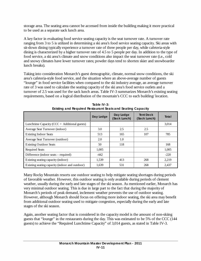
Monarch Mountain Master Development Plan - 2011
IV-11
storage area. The seating area cannot be accessed from inside the building making it more practical to be used as a separate sack lunch area.
A key factor in evaluating food service seating capacity is the seat turnover rate. A turnover rate ranging from 3 to 5 is utilized in determining a ski area’s food service seating capacity. Ski areas with sit-down dining typically experience a turnover rate of three people per day, while cafeteria-style dining is characterized by a higher turnover rate of 4.5 to 5 people per day. In addition to the type of food service, a ski area’s climate and snow conditions also impact the seat turnover rate (i.e., cold and snowy climates have lower turnover rates; powder days tend to shorten skier and snowboarder lunch breaks).
Taking into consideration Monarch’s guest demographic, climate, normal snow conditions, the ski area’s cafeteria-style food service, and the situation where an above-average number of guests “lounge” in food service facilities when compared to the ski industry average, an average turnover rate of 3 was used to calculate the seating capacity of the ski area’s food service outlets and a turnover of 2.5 was used for the sack lunch areas. Table IV-3 summarizes Monarch’s existing seating requirements, based on a logical distribution of the mountain’s CCC to each building/location.
Table IV-3: Existing and Required Restaurant Seats and Seating Capacity
Day Lodge Day Lodge (Sack Lunch)
Tent Deck (Sack Lunch) Total
Lunchtime Capacity (CCC + Additional guests) 3,014 Average Seat Turnover (indoor) 3.0 2.5 2.5 Existing Indoor Seats 513 165 107 785 Average Seat Turnover (outdoor) 2.0 1.0 Existing Outdoor Seats 50 118 168 Required Seats 1,005 1,005 Difference (indoor seats – required) -442 -220 Existing seating capacity (indoor) 1,539 413 268 2,219
Existing seating capacity (indoor and outdoor) 1,639 531 268 2,437
Many Rocky Mountain resorts use outdoor seating to help mitigate seating shortages during periods of favorable weather. However, this outdoor seating is only available during periods of clement weather, usually during the early and late stages of the ski season. As mentioned earlier, Monarch has very minimal outdoor seating. This is due in large part to the fact that during the majority of Monarch’s periods of peak demand, inclement weather prevents the use of outdoor seating. However, although Monarch should focus on offering more indoor seating, the ski area may benefit from additional outdoor seating used to mitigate congestion, especially during the early and late stages of the ski season.
Again, another seating factor that is considered in the capacity model is the amount of non-skiing guests that “lounge” in the restaurants during the day. This was estimated to be 5% of the CCC (144 guests) to achieve the “Required Lunchtime Capacity” of 3,014 guests, as stated in Table IV-3.
Monarch Mountain Master Development Plan - 2011
IV-12
H. PARKING CAPACITY The table below indicates that Monarch maintains 853 parking spaces within the base area, and at a current CCC of 2,870, Monarch should maintain 851 parking spaces. However, after periods of snow, Monarch’s parking capacity is reduced due to the increased area needed for snow storage. This area fluctuates throughout the season and can dramatically reduce the amount of parking available for guests.
Currently, Monarch experiences visitation during periods of the ski season in the range of 3,000 to 4,000 guests as demonstrated in the attached charts. On these days, not all guest vehicles can be accommodated in our current parking lot, and approximately 60 to 80 vehicles must park in the highway easement. In addition to parking guests in the highway easement, Monarch runs two shuttle buses form employees from Salida and the remaining employees park off-site at the Madonna Mine. The range of 3,000 to 4,000 guests that fit within the current parking system is driven by the number of people per car, which will fluctuate depending on the type of visitation we are experiencing. Parking vehicles and commuting employees in this manner creates an unsafe environment for guests and employees, as well as the general public traveling on U.S. Highway 50. By reducing the need to park vehicles along the highway, Monarch would substantially lower the risk of vehicle/pedestrian conflicts as guests and employees access base area facilities from their vehicles.
Access to Monarch is generally satisfactory. Situated immediately adjacent to U.S. Highway 50, Monarch’s access road is 600 feet long (refer to Figure IV-1). Maintained by Monarch management, the access road has a paved surface and meets generally accepted design standards. As mentioned above, overflow employee parking (60 to 100 spaces) is provided at the Madonna Mine lot located approximately 1 mile east on U.S. Highway 50 of the Monarch entrance. Moreover, when Monarch anticipates a peak day, employees are required to park at the overflow lot to maximize guest parking in the base area.
On-site, guest parking is available at the base area’s 8.3-acre surface parking lot as well as the entrance and exit roads. Monarch’s parking area is both paved and has a three-quarter inch gravel surface and is in good condition (i.e., no major washouts, sink holes, or other areas of distress). While the parking lot is relatively flat, Forest Service personnel have expressed concern about the lot’s propensity to contribute sediment to nearby streams (primarily through Monarch’s snow removal operations). Monarch has implemented mitigation measures to minimize impacts to water quality. These measures include: a sediment basin and drainage control efforts.
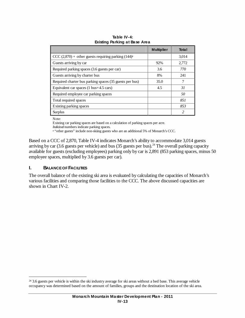
Monarch Mountain Master Development Plan - 2011
IV-13
Table IV-4:
Existing Parking at Base Area
Multiplier Total
CCC (2,870) + other guests requiring parking (144)a 3,014
Guests arriving by car 92% 2,772 Required parking spaces (3.6 guests per car) 3.6 770 Guests arriving by charter bus 8% 241 Required charter bus parking spaces (35 guests per bus) 35.0 7 Equivalent car spaces (1 bus=4.5 cars) 4.5 31 Required employee car parking spaces 50 Total required spaces 851 Existing parking spaces 853 Surplus 2
Note: Existing car parking spaces are based on a calculation of parking spaces per acre. Italicized numbers indicate parking spaces. a “other guests” include non-skiing guests who are an additional 5% of Monarch’s CCC.
Based on a CCC of 2,870, Table IV-4 indicates Monarch’s ability to accommodate 3,014 guests arriving by car (3.6 guests per vehicle) and bus (35 guests per bus).24 The overall parking capacity available for guests (excluding employees) parking only by car is 2,891 (853 parking spaces, minus 50 employee spaces, multiplied by 3.6 guests per car).
I. BALANCE OF FACILITIES The overall balance of the existing ski area is evaluated by calculating the capacities of Monarch’s various facilities and comparing those facilities to the CCC. The above discussed capacities are shown in Chart IV-2.
24 3.6 guests per vehicle is within the ski industry average for ski areas without a bed base. This average vehicle occupancy was determined based on the amount of families, groups and the destination location of the ski area.

Monarch Mountain Master Development Plan - 2011
IV-14
Chart IV-2: Ski Area Balance – Existing Conditions
As the above chart indicates, the existing ski area needs to achieve an improved balance of skier support facilities, in particular related to restaurant seating. Restaurant seating space is recognized as a specific constraint at Monarch. This is attributable to the low turnover rate due to families staying within the base area longer, especially those with small children not participating in ski school. Another reason for the low seating capacity is that there are 270 indoor day lodge seats essentially dedicated to sack lunch seating due to the lack of connectivity to the organized food service areas in the lodge. These factors contribute to the restaurant seating capacity being considerably lower than the existing CCC of 2,870.
J. ALTERNATIVE WINTER RECREATION Currently, Monarch does not provide alternative recreational opportunities for guests. Variety in guest opportunities would allow guests of different ages to engage in experiences that are currently not offered; thereby, improving the overall guest experience.
K. OPERATIONS (MAINTENANCE, UTILITIES)
1. Maintenance Facility Monarch’s only maintenance facility is located adjacent to the guest parking lot and is visible from the base area.
Comprised of approximately 3,100 square feet, the facility is a steel, wood, and concrete structure, heated by gas and wood systems. The facility is responsible for all major vehicle and lift maintenance operations and also features space for vehicle storage, parts storage, lift operations storage,
2,870 2,863
1,539
2,437
2,891
-
500
1,000
1,500
2,000
2,500
3,000
3,500
Lift and Trail Network Capacity
Guest Services Capacity
Food Service Seat Capacity (indoor)
Food Service Seat Capacity (including outdoor and sack
lunch)
Parking Capacity
GU
EST
S
CAPACITIES
Monarch Mountain Master Development Plan - 2011
IV-15
restrooms, and administrative space. In addition to the primary maintenance facility, there is a small storage building (approximately 250 square feet) adjacent to the maintenance building.
From an equipment standpoint, the facility is adequately equipped with tools that are common to ski facilities of Monarch’s size. Structurally, the maintenance facility appears to be in fair to good condition. However, the facility is much too small to service Monarch’s vehicles and provide maintenance to Monarch’s lifts and other base area buildings. Preliminary estimates show the facility being undersized by approximately 3,650 square feet.
2. Utilities
a. Water Monarch’s domestic water is supplied by two wells. One well produces an estimated maximum flow of 15 gallons per minute (gpm), while the other produces approximately 14 gpm. Domestic water storage is supplied by two, underground, concrete storage tanks which each feature a storage capacity of 24,000 gallons for a total of 48,000 gallons of storage. Monarch’s existing water supply and water storage system appears adequate to meet the ski area’s peak domestic water demand.
b. Sewage Monarch presently owns and operates a tertiary sewage treatment system that has a 23,000 gallon per day capacity. This system runs at 45 to 55% of its capacity in the winter and 5% of its capacity in the summer. The system was built in such a way that it can be expanded to double the capacity, as mandated by the State when the limits are reached. The system currently meets both State and Federal requirements.
c. Electricity Electrical power is supplied to Monarch over a Xcel 25,000 kVa transmission which provides the ski area with three-phase, incoming power (110-208-430v). Xcel also furnishes Monarch’s major transformers and distribution lines. Currently, the ski area’s electrical service requirements amount to approximately one-third of the existing power supply, or an estimated 8,000 kVa. Consequently, Monarch’s power supply is more than adequate for existing ski area operations.
d. Communication U.S. West Communications provides phone service to Monarch. Presently, the ski area has 32 incoming lines (system capacity of 200) which feed into a Nortel Network System. Telephone lines connect each building to each lift system, and telephone lines link the upper and lower terminals of each lift system. In addition, Monarch as two T1 lines—one for phone and one for internet/networking capabilities.
Monarch’s on-mountain telephone network is augmented with hand-held and mobile radios, two mobile stations, two base stations, a repeater and an approved tower location. The radio system services 70 hand-held radios. Monarch’s radio communication system affords a direct means of communication for Monarch’s management team, maintenance personnel, and the ski patrol operation. Monarch’s radios range from fair to good condition.
Monarch Mountain Master Development Plan - 2011
IV-16
Recently, the GMUG National Forest has installed a radio antenna which is attached and integrated into the infrastructure of the Monarch’s radio tower at the top of the Panorama lift. This additional antenna improved the radio coverage west of the continental divide for the USFS.
e. Weather Station Weather data collection is necessary for purpose of avalanche forecasting for both the ski area and for the Colorado Avalanche Information Center. Critical data such as wind speed/ direction, barometric pressure, and temperatures are collected from a weather station located at the highest point on the ridge above Mirkwood Basin. The weather instruments are located on a 10 foot tower and uses radio signals to transmit the data to Ski Patrol Headquarters. This weather station has been in place since 1990.
f. Fuel Storage Monarch’s fuel storage system is adequate to meet existing demand and is located above ground adjacent to the Maintenance Facility on the eastern portion of the SUP boundary. The fuel storage system is comprised of:
• 2 diesel storage tanks (6,000 and 250 gallons)
• 1 unleaded gasoline tank (4,000 gallons
• 5 propane tanks ([2]500 gallon tanks, 125 gallon tank, and [2]1,000 gallon tanks)
L. SUMMER RECREATIONAL OPPORTUNITIES Monarch operates primarily as a day-use, winter sports recreation area. Therefore, Monarch does not support summer operations such as mountain biking, hiking, chairlift rides, special events, etc.
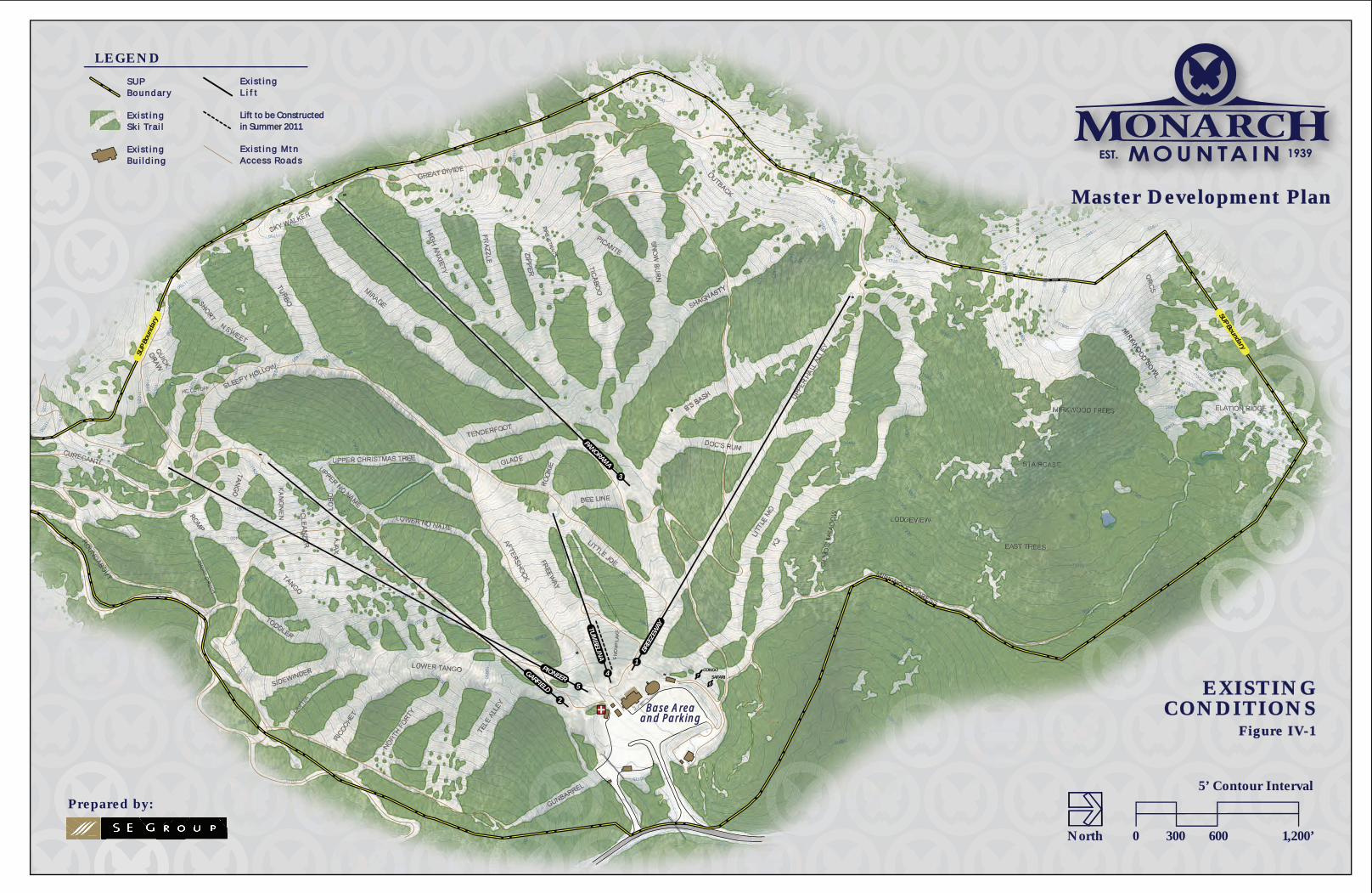
SUP BoundarySU
P Bo
unda
ry
BREEZEW
AY1
GARFIELD
2
PANORAMA
3
TUM
BELINA
4SAFARI
6
CONGO7
PIONEER5
Base AreaBase Areaand Parkingand Parking
0 300 600 1,200’
5’ Contour Interval
North
Prepared by:
LEGEND
E x i s t i n gE x i s t i n gL i f tL i f t
E x i s t i n g M t nE x i s t i n g M t nA c c e s s R o a d sA c c e s s R o a d s
S U PS U PB o u n d a r yB o u n d a r y
E x i s t i n gE x i s t i n gS k i Tr a i lS k i Tr a i l
E x i s t i n gE x i s t i n gB u i l d i n gB u i l d i n g
EXISTINGEXISTINGCONDITIONSCONDITIONS
Figure IV-1Figure IV-1
Master Development PlanMaster Development Plan
Lift to be ConstructedLift to be Constructedin Summer 2011in Summer 2011

WatsewaterWatsewaterTreatmentTreatment
PlantPlant
Equipment RentalsEquipment RentalsSprung StructureSprung Structure
Ski PatrolSki PatrolHeadquartersHeadquarters
Tent DeckTent Deck
RestroomsRestrooms
Children’s Ski School/Children’s Ski School/DaycareDaycare
Day LodgeDay LodgeVehicleVehicle
MaintenanceMaintenanceBuildingBuilding
SUP Boundary
BREEZEW
AY
1
GARFIELD
2
TUM
BELINA
4SAFARI
6
CONGO7
PIONEER5
Entry Road
WatsewaterTreatment
Plant
Exit Road
US Highway 50
Equipment RentalsSprung Structure
Ski PatrolHeadquarters
Tent Deck
Restrooms ParkingLot
Children’s Ski School/Daycare
Day LodgeVehicle
MaintenanceBuilding
Lift Maintenance OfficeLift Maintenance Office(Historic Cabin)(Historic Cabin)
Lift Maintenance Office(Historic Cabin)
Employee Ski and BoardEmployee Ski and BoardStorage BuildingStorage Building
Employee Ski and BoardStorage Building
Carpet to be Constructed
Carpet to be Constructed
in Summ
er 2011
in Summ
er 2011
Carpet to be Constructed
in Summ
er 2011
0 150 300 600’
5’ Contour Interval
North
BASE AREABASE AREADETAILDETAIL
Figure IV-2Figure IV-2
Deck

Chapter 5 Previously Approved Projects,
Not Yet Implemented
Monarch Mountain Master Development Plan - 2011
V-1
V. PREVIOUSLY APPROVED PROJECTS, NOT YET IMPLEMENTED
The projects detailed in this section have been previously approved, but have not yet been implemented. It is anticipated that the majority of these projects will ultimately be implemented as capital for on-mountain improvements becomes available. Prior to project implementation, the Forest Service will review project consistency with the 1984 LRMP for the Pike and San Isabel Nationals Forests standards and guidelines and determine if additional analysis is warranted due to changed environmental and social conditions, and/or new planning and regulatory guidance. Applicable analysis and approvals are contained in the following documents:
• 1998 Monarch Ski Area Master Development Plan, Environmental Assessment
• 1999 Monarch Ski Area Master Development Plan, Decision Notice and Finding of No Significant Impact
All of the projects listed below were previously approved via the 1999 Decision Notice and Finding of No Significant Impact Monarch Ski Area Master Development Plan (1999 DN).
A. LIFTS The previously approved lift upgrades detailed here have been included in the appropriate proposed capacity calculations within this MDP.
1. Breezeway Lift The Forest Service approved the upgrade of the Breezeway lift as a bottom-drive, fixed-grip, four-person chairlift. The previous approval authorized the relocation and realignment of the chairlift. Although, new planning has revealed that the current alignment of the Breezeway lift is appropriate, but the bottom terminal should be relocated up the lift line approximately 100 feet. In addition, new planning revealed that a four-person chair is not warranted and only a triple is needed. These modifications to the previous approval are addressed in further detail in Chapter VI.
2. Snowflake Surface Lift25 The Forest Service approved the installation of the Snowflake surface lift to be located between the Tumbelina and Breezeway lifts. This MDP proposes a modification to the previous approval; moreover, the Snowflake surface lift would be installed as a conveyor lift in a different location. The alignment of the conveyor lift would parallel the Tumbelina lift, avoiding wetlands in the previously-approved alignment. These modifications to the previous approval are addressed in further detail in Chapter VI.
B. TERRAIN The Forest Service approved a 36-acre increase to Monarchs’ trail network. The majority of the increase will be the result of trail widening, with a minor amount of new trail construction. To date, Monarch has implemented a portion of this approved trail clearing. Therefore, this MDP proposes to complete the previously-approved upgrades to Monarch’s terrain network through new trail construction and trail widening.
25 This lift is scheduled to be constructed during the 2011 summer construction season.
Monarch Mountain Master Development Plan - 2011
V-2
1. Trail Development The Forest Service approved development of a new trail connecting Turbo and Sleepy Hollow with Mirage. The trail will require approximately 3.5 acres of vegetation removal and will improve skier circulation within the terrain serviced by the Panorama lift. The previously-approved trail will have an average skiable width of approximately 110 feet and offer advanced-intermediate skiers a new terrain option.
2. Trail Widening The Forest Service approved additional terrain modifications to facilitate necessary widening and trail connection projects. These projects were approved to relieve congestion and improve the ski area’s overall skier circulation. As stated, Monarch intends to complete this approval by removing approximately 14 acres of vegetation. Previously-approved trail widening applies, but is not limited to the following trails: Romp, Drifter, Sleepy Hollow, Upper Christmas Tree, Upper No Name, Lower No Name, Glade, Snowburn, K2, and areas within the Safari teaching area.
C. FACILITIES
1. Mountain-Top Facility The Forest Service approved the construction of a mountain-top facility to be located adjacent to the top terminal of the Panorama lift. The 700-square foot yurt type facility will accommodate seating for 50 guests and provide limited food service. In addition, the facility will have composting toilets and will function as a warming hut. The previously-approved ski patrol function for the Mountain-top facility is not part of this MDP.
2. Mid-Mountain Facility The Forest Service also approved construction of a small mid-mountain facility, sun deck, and associated restrooms facility as part of the 1999 DN. This facility was approved to be approximately 300 square feet in size and offer limited food preparation (barbeque) as well as restroom facilities in the form of composting toilets. The attached sun deck will accommodate approximately 150 people. Also included with the mid-mountain facility is the relocation of the 1,300-square foot Tent Deck currently located at the base area. The Tent Deck would be located adjacent to the mid-mountain facility and provide additional on-mountain seating.
D. SNOWMAKING The Forest Service approved the development of snowmaking capabilities on approximately 33 acres of skiable terrain to improve early snow conditions and ensure adequate coverage on popular novice and intermediate terrain. The snowmaking system will utilize high efficiency, fan-type (airless) snowmaking equipment to augment natural snowfall by approximately 9 inches on each of the proposed trails to be covered. Monarch is previously approved to provide snowmaking coverage on the following trails: Safari, Sleepy Hollow, Freeway, Glade, Little Jo, and Snowflake.
The outstanding previously-approved snowmaking coverage requires the construction of a snowmaking pond located immediately south of the guest parking lots. Supplied by an unnamed tributary that flows through the base area, the pond will be approximately 1 acre in size with an average depth of 3 feet. Necessary water lines and power lines will require approximately 11,000 feet of trenching.

Monarch Mountain Master Development Plan - 2011
V-3
E. PREVIOUSLY APPROVED PROJECTS NOT CONTAINED WITHIN THIS MDP The Forest Service approved projects that Monarch will not pursue and are therefore not included in the upgrading plan contained within this MDP. These projects include the Gunbarrel surface lift, a snowplay area, and a Maintenance Facility.
1. Gunbarrel Surface Lift The Forest Service approved a surface lift located on the southeast portion of Monarch’s SUP area. This lift was approved to be approximately 1,125 feet long with a capacity of 600 people per hour. Its primary function was to eliminate the uphill walk required for accessing the Tele Alley, North Forty and Gunbarrel trails. This previously approved project is not included in this MDP because Monarch determined that the terrain this lift is supposed to service would remain underutilized, even with installation of this lift. Therefore, the lack of an improvement to the recreation experience does not justify the increase in operational costs associated with this lift.
2. Snowplay Area The Forest Service approved the creation of a snowplay area to be located along the northeastern edge of the parking lot, north of the Safari trail. The snowplay area would have been serviced by a small handle tow, would allow sledding, tubing, shallow halfpipes, and a lengthy run out/ transition zone. Monarch has elected not to include the original design that was previously-approved. Recent planning has developed an improved site plan for a snow tubing facility. This facility is discussed in Chapter VI.
3. Maintenance Facility The Forest Service approved for Monarch to expand and relocate the existing Maintenance Facility north of the base area. The upgraded facility would have been approximately 10,000 square feet in size and would have provided facilities for vehicle maintenance and operations personnel. This previously-approved project is not included in this MDP because of the excessive costs associated with moving the facility. Moreover, the previously-approved location for the Maintenance Facility can be better utilized for overflow parking. The addition of a new vehicle maintenance facility is planned adjacent to the existing maintenance facility; refer to Chapter VI for the detailed discussion of this facility.

Chapter 6 Proposed Upgrading Plan
Monarch Mountain Master Development Plan - 2011
VI-1
VI. PROPOSED UPGRADING PLAN
A. SUMMARY OF UPGRADING PLAN The purpose of this upgrading plan is to provide direction for the future development of Monarch, which ensures a balance of facilities and variety of amenities to provide an exceptional guest experience and operational efficiencies. This plan will allow Monarch to remain competitive in the destination and day-skier market, help retain existing guests, and attract new visitors. The upgrading plan is depicted in Figures VI-1 and VI-2.
Monarch will perform a series of ski area upgrades as detailed in this section. These projects include:
• Chairlift upgrades and installation
• Conveyor lift installations
• Upgrades to existing trail network
• Installation of previously approved snowmaking infrastructure
• Adjustment of Monarch’s SUP boundary to include lift-served skiing in No Name Basin
• Installation of new on-mountain guest service facilities
• Increase in parking capacity
• Upgrades to existing guest service facilities
• Construction of snow tubing facility
The proposed upgrading plan includes on-mountain and base area improvements designed to meet guest expectations that provide an enjoyable recreational and social experience at the ski area. As stated in Chapter I, Monarch provides a skiing experience for a diverse range of clientele.
B. ALPINE FACILITIES (LIFTS AND TERRAIN)
1. Ski Area-Wide Upgrades (Front-side and No Name Basin) Monarch currently operates five chairlifts and two conveyor lifts. With the upgrading plan:
• 1 new chairlift would be installed
• 1 existing chairlift would be upgraded
• 1 existing conveyor lift would be relocated
• 2 new conveyor lifts would be installed
• 1 new conveyor lift to service a snow tubing facility
• Implement the previously approved conveyor lift adjacent to the Tumbelina Chairlift (to be installed during the 2011 summer construction season)
Monarch Mountain Master Development Plan - 2011
VI-2
The existing developed ski trail network accommodates a wide range of skier ability levels, from novice to expert.26 With the upgrading plan Monarch would:
• Implement the previously approved trail widening within existing terrain network
• Implement previously approved new trail development
• Develop two short trail segments within Monarch’s current terrain network
• Provide additional gladed tree skiing within Monarch’s current terrain network
• Develop new trails and gladed tree skiing opportunities within No Name Basin
Additionally, Monarch plans on providing another recreational opportunity with a snow tubing facility adjacent to the Safari teaching area. The snow tubing facility is discussed in section J of this chapter and should be noted that the tubing lift and associated buildings are not included in the analysis of the skier services facilities and on-mountain lifts. Furthermore, the conceptual plan of the snow tubing facility would be to attract guests from the current and expected guests that would be skiing and arriving at the ski area with skiers. Therefore, facilities do not need to be planned to accommodate additional guests above the Upgrading Plan CCC.
In summary, the upgrading plan includes additions to Monarch’s existing lift-served trail network both within and outside the current SUP boundary. Monarch’s trail network currently offers approximately 270 acres of lift-served terrain and approximately 130 acres of managed hike-to terrain within Mirkwood Basin. The proposed developed lift-served trail network at Monarch will total approximately 347 acres of skiable terrain. In addition to developed trails, Monarch would also glade existing inter-trail tree islands on the front-side and in No Name Basin totaling 21 acres and 58 acres, respectively. Monarch would augment the existing 130 acres of managed, hike-to terrain in Mirkwood Basin with 27 acres of additional gladed terrain. Together, these total approximately 583 acres that Monarch would patrol, control and maintain for skiing.
a. Lift-Served Terrain In addition to the previously-approved trail projects discussed in Chapter V, with this upgrading plan, Monarch also proposes several trail widening/tree clearing projects to improve identified skier circulation concerns. Approximately 1.5 acres of widening and clearing and approximately 6 acres of grading is proposed on the front-side (refer to Figure VI-1).
Terrain Distribution by Ability Level The following table and chart compares the existing distribution of terrain capacity by skier ability level with the distribution after upgrading. These exhibits show that the upgraded trail network at Monarch will continue to accommodate a range of skier ability levels from novice to expert. With the proposed upgrades, the terrain distribution figures demonstrate that a shortage of beginner and intermediate terrain will persist given the skier/ rider market. In addition, the terrain distributions for the low-intermediate and advanced-intermediate ability levels increase, while the novice and expert distributions slightly decrease. The reduction in terrain capacity distribution of the novice and expert categories is primarily a result of changing the overall percentages due to the increases in acreages for low-intermediate, intermediate, and advanced-intermediate ability levels.
The upgrading plan includes the addition of approximately 0.6 acre of beginner terrain. As previously stated, a shortage of beginner terrain would persist. This is due to the limited slope angles available at Monarch. Over the past several years, Monarch has made ski school operational decisions that have improved the usability and efficiency of the beginner terrain, which has improved the guest experience.
26 It should be noted that Monarch provides approximately 0.2 acre dedicated to beginner terrain located in the Safari teaching area. However, this terrain is exclusively utilized for children’s ski and ride school.
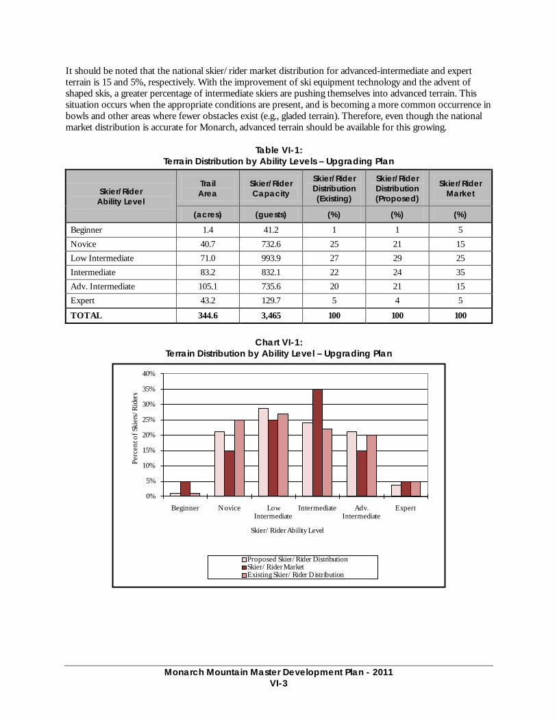
Monarch Mountain Master Development Plan - 2011
VI-3
It should be noted that the national skier/rider market distribution for advanced-intermediate and expert terrain is 15 and 5%, respectively. With the improvement of ski equipment technology and the advent of shaped skis, a greater percentage of intermediate skiers are pushing themselves into advanced terrain. This situation occurs when the appropriate conditions are present, and is becoming a more common occurrence in bowls and other areas where fewer obstacles exist (e.g., gladed terrain). Therefore, even though the national market distribution is accurate for Monarch, advanced terrain should be available for this growing.
Table VI-1: Terrain Distribution by Ability Levels – Upgrading Plan
Skier/Rider Ability Level
Trail Area
Skier/Rider Capacity
Skier/Rider Distribution (Existing)
Skier/Rider Distribution (Proposed)
Skier/Rider Market
(acres) (guests) (%) (%) (%)
Beginner 1.4 41.2 1 1 5 Novice 40.7 732.6 25 21 15 Low Intermediate 71.0 993.9 27 29 25 Intermediate 83.2 832.1 22 24 35 Adv. Intermediate 105.1 735.6 20 21 15 Expert 43.2 129.7 5 4 5
TOTAL 344.6 3,465 100 100 100
Chart VI-1:
Terrain Distribution by Ability Level – Upgrading Plan
0%
5%
10%
15%
20%
25%
30%
35%
40%
Beginner Novice Low Intermediate
Intermediate Adv. Intermediate
Expert
Perc
ent o
f Ski
ers/
Rid
ers
Skier/Rider Ability Level
Proposed Skier/Rider DistributionSkier/Rider MarketExisting Skier/Rider Distribution
Monarch Mountain Master Development Plan - 2011
VI-4
Managed Hike-To Terrain In addition to the proposed developed trail network, Monarch would maintain approximately 130 acres of managed hike-to skiing in Mirkwood Basin. A glading project is proposed in Mirkwood Basin to enhance the existing managed, hike-to terrain experience (refer to Figure VI-1). Managed hike-to terrain is growing in popularity within the Colorado skier market as evidenced by the proliferation and popularity of off-piste terrain within controlled ski area boundaries.
2. Front-side Lifts and Terrain
a. Lifts The lift upgrading plan calls for the relocation of the previously approved upgraded Breezeway lift’s bottom terminal and the installation of two new conveyor lifts and relocation of one existing conveyor lift within the Safari children’s teaching terrain.
Breezeway Lift As stated in Chapter V, Monarch is including within this MDP the previously-approved upgrade of the Breezeway lift. Monarch has decided to upgrade Breezeway from a fixed-grip double (1,000 people per hour) to a fixed-grip triple (1,800 people per hour) instead of a fixed-grip, four-person chair. However, not included in this upgrading plan is the previously-approved relocated alignment to the northeast. In this MDP, the bottom terminal of the Breezeway lift would be moved approximately 100 feet upslope (northeast) of the bottom terminal’s existing location to an approximate elevation of 10,840 feet. In addition, grading would occur in the area of the relocated bottom terminal to provide a smoother and consistent terrain gradient that provides easier access for guests to the Breezeway lift from the base area and parking lots.
Relocating the bottom terminal would also benefit the Snowflake teaching terrain adjacent to Monarch’s base area through terrain widening and reducing the existing bottleneck effect occurring between the bottom terminals of the Tumbelina and Breezeway lifts.
Breezeway’s top terminal would remain in the location of the existing terminal at approximately 11,675 feet.
Tumbelina Lift The existing Tumbelina lift is well aligned and maintains an adequate lift capacity for the terrain it serves. To better serve the terrain, Monarch proposes the discontinued use of the existing mid-unload station. Discontinuing the use of the mid-unload can be accomplished in conjunction with the installation of the Snowflake Conveyor. The removal of the mid-unload and the installation of the Snowflake Conveyor will better disperse skiers across terrain that is currently underutilized.
Safari Lift System To enhance the children’s learning experience, the existing Congo conveyor lift would be relocated and two additional conveyor lifts installed within Monarch’s Safari children’s teaching area (refer to Figure VI-2).
The Congo conveyor would be slightly relocated to provide access to the Safari teaching area from the new Children’s Center with an average slope gradient of 8%. Safari will remain in its current location on the existing grade of approximately 10%. To compliment and expand upon the existing lifts, two additional conveyors will be installed adjacent to the Congo and Safari conveyors. An 80-foot long and 150-foot long conveyor lifts would be installed on 10% and 12% slopes. This proposed lift configuration would provide a more natural learning progression as the successive conveyor lifts each services a slightly steeper grade than the preceding lift.
Monarch Mountain Master Development Plan - 2011
VI-5
b. Terrain In addition to the previously-approved trail projects that are carried forward in this MDP, two relatively short trail segments, several trail widening/tree clearing projects are proposed to improve identified skier circulation concerns. Approximately 0.8 acres between two short trail segments, 1.5 acres of widening and clearing, and approximately 6 acres of grading is planned on the front-side (refer to Figure VI-1), including:
• Two trail segments are planed to be developed. One between High Anxiety and Mirage and the other between Rookie and Glade, respectively 0.6 acres and 0.2 acres would be cleared. These trail connections would improve skier and rider circulation on the mountain.
• Trail widening and clearing for the bypass trail from K2 to Little Mo, which would route skiers on K2 above the Safari beginner area.
• Trail widening on Sleepy Hollow and Ticaboo trails to improve skier circulation.
• Grading on Romp trail in conjunction with previously-approved trail widening would improve skier circulation by reducing a “break-over” on the trail, which currently creates trail congestion.
3. SUP Boundary Adjustment and Associated Lift and Terrain As stated in Chapter II, the existing 800 acre SUP boundary would increase to 1,144 acres to include No Name Basin. Therefore, the proposed SUP boundary would occur on the Pike and San Isabel National Forests and the Grand Mesa, Uncompaghre, and Gunnison (GMUG) National Forests. No Name Basin lies on the west side of the Continental Divide, and includes portions that are currently used by the Monarch Snowcat Tours. Approximately 344 acres within No Name Basin are proposed to offer 139 acres of lift-served skiing under this MDP.
No Name Basin is located on NFS lands managed by the GMUG. As such, the 1991 GMUG LRMP designates No Name Basin under Management Prescription 1B (Provides for existing and potential winter sports sites). Management Prescription 1B includes a much larger area of terrain (approximately 5,400 acres) when compared to the proposed SUP area. Management Prescription 1B states:
Management emphasis provides for downhill skiing on existing sites and maintains selected inventoried sites for future downhill skiing recreation opportunities.27
Therefore, the proposed SUP boundary adjustment and development of the proposed ski terrain would be consistent with the 1991 GMUG LRMP. During future site-specific NEPA analysis for No Name Basin, the SUP boundary would be adjusted to accommodate No Name Basin projects. Details of proposed upgrades to No Name Basin are addressed below.
a. No Name Lift A new fixed-grip double chair is proposed to be installed in No Name Basin; located on the backside of the existing Monarch ski area on public lands managed by the GMUG National Forests. The No Name lift would have a slope length of approximately 2,725 feet and an hourly design capacity of approximately 1,200 people per hour.
The top terminal of the proposed No Name lift would be located at approximately 11,700 feet in elevation on top of a natural bench along the Continental Divide separating No Name Basin from the existing developed ski area. This location was selected due to the existing 10% decline on either side of the lift’s terminal, which would provide efficient skier egress from the terminal area and easy access to the terrain within No Name 27 USDA Forest Service. 1983, as amended in 1991. Land and Resource Management Plan – Pike and San Isabel National Forests; Comanche and Cimarron Grasslands. p. III-92

Monarch Mountain Master Development Plan - 2011
VI-6
Basin. The bottom terminal would be located at approximately 10,740 feet in elevation at the bottom of the revised SUP area (addressed above) within No Name Basin. As indicated in Figure VI-1, the proposed alignment would be located within the north central part of No Name Basin. The top and bottom terminals would meet the Forest Service scenic quality standards of “Modification.”
Construction and maintenance of the No Name lift bottom terminal in the proposed remote location can be accomplished without construction of a road. Furthermore, all infrastructure, equipment, and tools would be transported to the bottom terminal through a combination of the following methods: use of a helicopter, over-the-snow via snowcat or snowmobile, or carried down by hand in the summer. Grading and tower excavation would be accomplished by utilizing low-impact excavating equipment and hand digging.28
b. No Name Basin Terrain The new lift would offer guests of Monarch access to approximately 62 acres of developed trails encompassing low intermediate, intermediate and advanced-intermediate terrain, with a vertical rise of approximately 960 feet. Approximately 58 acres of gladed terrain will also be developed in conjunction with this proposed lift and trails project. Therefore, the proposed terrain within No Name Basin would total approximately 120 acres, which would be initially accessed from the front-side of the ski area via the Breezeway or Panorama lift.
The development of No Name Basin for downhill skiing would enhance the recreation experience for guests of Monarch through offering new terrain that caters specifically to the intermediate ability level. This type of advanced terrain would be a high-quality addition to Monarch’s existing advanced terrain, as Monarch currently lacks lift-served, gladed tree skiing. The addition of No Name Basin would better accommodate the increasing visitation Monarch is experiencing. This terrain would better disperse guests across the proposed SUP and allow guests to feel even closer to nature in No Name Basin. No Name Basin would perpetuate the role that Monarch leads in the community of attracting families, and children in particular, to the Forest.
The specifics of the No Name Basin lift and trails proposal are illustrated on Figure VI-1.
C. COMFORTABLE CARRYING CAPACITY The calculation of Monarch’s Upgrading Plan CCC is described in Table VI in Appendix A. As illustrated, the upgrading program increases the CCC of the lift and trail network at Monarch to 3,490 guests per day, an increase of 620 guests, or 22%. The CCC for Monarch is related to lift capacity and the functions that lifts serve to move and distribute guests around the mountain. As stated in Chapter IV, visitation at Monarch has exceeded the existing CCC of 2,870 several times throughout the past few seasons due to the affordability and broad range of guests the ski area serves. The goal of this MDP and the upgrading plan is to better accommodate existing visitation levels within the upgraded capacity of 3,490 guests on a comfortable day.
D. SKI TRAIL DENSITY ANALYSIS The trail density analysis compares the calculated trail density for each lift pod to the desired trail density for that area.
When the planned skiers per acre are correctly balanced resort-wide, the existing densities at Monarch are at desirable levels. As stated in Existing Conditions, this is not a typical occurrence as the intermediate trails are occasionally congested and this situation is anticipated to increase in frequency as visitation continues to increase in the future. Since significant increases in skier density would decrease the quality of the skiing experience, it is a goal of the upgrading plan to balance increases in lift capacity with commensurate increases in skiing terrain capacity. The density analysis for the upgrading plan at Monarch is illustrated in Table 8 in
28 “Low-impact” refers to excavating equipment that is specifically designed to have low ground pressure.

Monarch Mountain Master Development Plan - 2011
VI-7
Appendix A. At the planned capacity level, the Tumbelina lift would continue to exhibit the highest trail density of any other lift on the mountain. This increase in the density index over existing conditions is acceptable due to the nature of the terrain the Tumbelina lift serves (novice and ski school terrain) where it is acceptable to have more people skiing at slow speeds within a concentrated area.
The addition of intermediate, advanced-intermediate, and advanced terrain as well as the No Name Basin lift under the upgrading plan, serves to distribute skier densities across similar ability level terrain serviced by the Garfield and Panorama lifts. Thus, lower trail densities within these lift pods would occur as indicated in Table 8 in Appendix A. This is a result of fewer people skiing Panorama’s terrain pod as they would now be skiing similar terrain within No Name Basin. Under the upgrading plan, Monarch’s overall trail density index would be reduced providing even more space for guests skiing throughout the ski area.
E. SNOWMAKING COVERAGE The upgrading plan calls for the implementation of previously-approved snowmaking infrastructure and a coverage area for the snow tubing facility to be operated within Monarch’s existing SUP boundary (refer to Figure VI-1). As described in Chapter V, the Forest Service approved the development of snowmaking coverage on approximately 33 acres of skiable terrain to improve early snow conditions and ensure adequate coverage on popular novice and intermediate terrain. The snow tubing facility would need 1.6 acres of snowmaking coverage.
Chapter V also discussed the Forest Service approval of a snowmaking pond immediately south of the guest parking lots. This location would have a dual function – a snowmaking pond and a snow storage area for parking lot removal. At this location, disclosed on Figures VI-1 and VI-2, Monarch maintains the option to increase the capacity of the snowmaking pond by either digging the pond deeper or increasing the surface area. This will allow for flexibility in future snowmaking needs.
F. GROOMING OPERATIONS With implementation of the upgrading plan, Monarch would groom terrain similar to current conditions. This would include the grooming of intermediate and certain advanced-intermediate terrain proposed within No Name Basin.
G. SKIER SERVICES SPACE AND FOOD SERVICE SEATING Sufficient guest service space should be provided to accommodate the upgraded ski area’s CCC of 3,490 guests per day. The CCC is the design standard and planning tool defined as the number of daily visitors a ski area can comfortably or efficiently accommodate at one time without overburdening the ski area’s infrastructure. In essence, CCC is a guest attendance level that can be serviced by the ski area while operations remain optimally functional. As such, the distribution of the CCC is utilized to determine guest service capacities and spatial requirements for skier services at the base area and previously-approved on-mountain facilities. The CCC should be distributed between each guest service facility location according to the number of guests that would be utilizing the lifts and terrain associated with each facility.
Based upon a CCC of 3,490 skiers, the distribution described in Table 13 in Appendix A and Chart VI-2 below, compares the upgraded space use allocations of the visitor service functions to industry standards for a ski area of similar market orientation and regional context as Monarch. Square footage figures contained in the table are calculated to illustrate how the ski area compares to industry averages, and should not be considered absolute requirements.
Monarch Mountain Master Development Plan - 2011
VI-8
1. Skier Services Under the upgrading plan, Monarch’s base area would continue to be the only staging location at the ski area. This staging location would be expanded to offer more diverse commercial skier services such as retail, rental, and food services. Under the upgrading plan, Monarch would:
a. Base Area • Construct additions to the existing Day Lodge
• Enclose the loading dock at the Day Lodge for additional storage
• Construct a ski school/ children’s center building adjacent to the Safari teaching area
• Construct a two story building that would replace existing tent deck for overflow seating and administrative offices
• Replace stairs and retaining wall structure adjacent to Day Lodge and install a wheelchair lift along side the new stairs
• Replace the existing Ski Patrol building with a two story building that will include a Patrol Headquarters on the upper floor and medical clinic on the lower floor
• Relocate the existing Ski Patrol building adjacent to the maintenance shop to be used as offices for the Lift and Slope Maintenance departments
• Construct an approximately 750-square yurt adjacent to the existing Ski Patrol building for the Monarch Snowcat Tours, meeting location, check-in, lunch, and check-out
b. On-Mountain • Construct the previously-approved mountain-top warming hut at the near the top of the Panorama
lift
• Construct the previously-approved mid-mountain food and beverage facility near the bottom of the Panorama lift with sun deck and adjacent composting toilet building (relocate the existing Tent Deck from base area and historic cabin from the maintenance shop lot to this location)
• Relocate the existing Children’s Center modular building to function as a guest service building at the planned the tubing facility
• Construct a planned warming hut at the bottom of the proposed No Name lift
c. Base Area Buildings In order to provide easy and efficient skier access and circulation within the base area, Monarch is proposing various upgrades to the base area infrastructure. Upgrades include but are not limited to expanding existing guest services in the Day Lodge. The specifics of the proposal are illustrated on Figure VI-2.
As shown in Table 10 in Appendix A, at 58,229 square feet, Monarch’s proposed base area guest service space falls just above the recommended range of 41,840 to 52,200 square feet. This increase in guest service space from the existing condition will improve the guests experience as they flow through the base area facilities.
Day Lodge The Day Lodge would continue to be the primary service area for guests of Monarch. Although well maintained, the Day Lodge is an older building and accommodates 100% of the guests skiing at Monarch. As such, in order to continue to provide quality guest services, and accommodate existing and future skier visitation, the Day Lodge is in need of upgrades. The goal is to maintain and improve the guest service level
Monarch Mountain Master Development Plan - 2011
VI-9
at the base area location by providing convenience and easy access to the base area and adjacent lifts from the parking lot, and to provide a better balance between the number of guests and the amount of guest service space.
To accommodate the anticipated increase in skier visitation, the Day Lodge would need to be considerably expanded and upgraded over existing conditions. Tables 9 and 10 in Appendix A illustrate existing and proposed space use of Monarch’s base area buildings. Under the upgrading plan, the Day Lodge would be expanded to include an additional 3,420 square feet. Restaurant and bar seating (500 seats) along with the sack lunch area with be expanded and improved with this addition. Monarch plans to enclose the existing 720-square foot Day Lodge loading dock and convert that area storage space, and shipping and receiving. Along with this the house freezer and refrigeration area would be expanded.
Monarch has also indicated that additional ticket windows are needed. As the Day Lodge roof line is extended to enclose the existing loading dock, the new roof section would continue towards the existing ticket windows allowing new ticket windows to be covered by the roof extension.
As stated in Chapter IV, the existing staircase and retaining walls adjacent to the Day Lodge are in disrepair. Monarch proposes to reconstruct these structures to the appropriate appearance and quality that a guest would expect. Monarch also plans to install a wheelchair lift that would be ADA accessible taking guests from the parking lot level to the snowfront level.
The space recommendations contained in Table IV-2 are directly related to the distribution of the ski area’s capacity to the various guest service facilities located in the base area and on-mountain. This distribution responds to the guest demographic of Monarch as well as guest behavior and movement around the mountain and base area throughout the day. As such, it is important to provide adequately sized facilities to respond to this guest demographic and circulation.
A complete inventory of existing and proposed resort-wide guest services space use is described in Table 13 in Appendix A.
Ski School and Children’s Center In order to improve the children’s learning experience, the upgrade plan calls for the construction of an approximately 8,000-square foot, two story structure. This structure would be located immediately adjacent to the existing Children’s Center and the Safari teaching area. The slope level, which is located approximately 100 feet from the Safari teaching slope, would accommodate the Children’s Center and Junior Mountain program. Functions on the lower level would include a Ski School meeting room, a lift operations office, and locker rooms for lift operations, guest services, rental operations.
The current Ski School meeting room and offices in the Rental Sprung will be converted to retail sales and additional seating.
Overflow Seating and Administrative Offices Building An overflow seating facility is proposed in the location of the existing tent deck adjacent to the Day Lodge. This two story facility would be approximately 5,000 square feet and would provide seating room for 300 guests during busy weekends and when large groups visit the ski area. Limited food service would be available at this facility. A small porting of this building, 700 square feet, would be dedicated to administrative offices.
Monarch Snowcat Tours Facility Currently Snowcat Tours guests meet in a small room on the upper floor of the day lodge. Monarch plans to construct a dedicated facility for those guests to meet and check-in at the beginning of their day, have lunch,
Monarch Mountain Master Development Plan - 2011
VI-10
and to wrap up their day. This facility would be a yurt-type structure approximately 750 square feet located adjacent to the Ski Patrol Building.
d. On-Mountain Facilities Further detail of each individual guest service location is required to illustrate specific locations and amount of additional space recommended throughout the ski area, in order to optimize opportunities for improvements to the guest experience. Tables 10 and 12 contained in the Appendix A address the proposed upgraded space which calls for the addition of two previously approved on-mountain facilities and new proposed facility.
Previously-Approved On-Mountain Facilities Mountain-top Facility
○ The previously-approved mountain-top facility would be located near the top of the Panorama lift. This yurt-type warming hut would include 50 seats, limited pre-packaged food service and restroom facilities. At approximately 750 square feet.
Mid-mountain Facility ○ The previously approved mid-mountain facility would be located near the bottom terminal of the
Panorama lift and approximately 300 square feet in size with a 150-seat outdoor sun deck. Additional seating would be provided by the existing tent deck currently located in the base area, which is proposed to be relocated adjacent to the Mid-mountain facility. The 1,300-square foot tent deck would provide approximately 100 indoor seats, since it is anticipated that the central location of mid-mountain facility would make it a popular on-mountain destination.
○ A composting toilet building is also planned to be constructed adjacent to the mid-mountain facility
Proposed On-Mountain Facilities Tubing Facility Guest Service Facility
○ The existing Children’s Center modular building is planned to be relocated at the bottom of the tubing facility and adjacent to the proposed parking. This building would have functions of ticketing/check-in, food service limited to pre-packaged beverage and food items, and a guest warming facility.
○ The small employee ski and board storage building adjacent to the existing Children’s Center will also be relocated to the tubing facility to provide additional storage.
No Name Basin Hut ○ To accommodate guests within No Name Basin, a small warming hut is proposed to be located
adjacent to the bottom terminal of the proposed No Name lift. The proposed warming hut would be approximately 750 square feet in size and provide seating for approximately 50 guests. In conjunction with the proposed and previously-approved on-mountain facilities, the No Name warming hut facility would help distribute guests skiing on Monarch and eliminate the need for all skiers to descend to the base area for basic services such as food, restroom, and protection from adverse weather.

Monarch Mountain Master Development Plan - 2011
VI-11
2. Food Service Seating Food service seating at Monarch would be provided at the following locations:
• Expanded Day Lodge
• Proposed overflow seating facility
• Previously-approved mountain-top facility
• Previously approved mid-mountain facility
• Proposed No Name Basin hut
As stated in Chapter IV, a key factor in evaluating restaurant capacity is the turnover rate of the seats. A turnover rate of 3 to 5 times is the standard range utilized in determining restaurant capacity. Sit-down dining at ski areas typically results in a turnover rate of three, while “fast food” cafeteria style dining is characterized by a higher turnover rate. Furthermore, weather has an influence on turnover rates at ski areas, as on snowy days skiers would spend more time indoors than on sunny days. Due to the family oriented demographic and high-altitude inclement weather, an average turnover rate of 2.5 to 3 was used for the indoor base area facilities, 3 was used for on-mountain facilities at Monarch. Lower turnover rates were used for the outdoor seating and sack lunch areas due to the situation where an above-average number of guests “lounge” in these areas.
Seating and restaurant space recommendations are directly related to the lunchtime capacity. The lunchtime capacity is determined by the distribution of each lift pod’s CCC. It is assumed that skiers would prefer to dine at the facility closest to the area where they are skiing. To allow for this convenience, it is important to provide on-mountain dining services to accommodate the lunchtime capacity of the area.
Table 14 in Appendix A summarizes the seating requirements at Monarch, based on a logical distribution of the CCC to each food service building and location. As shown Table 14 in Appendix A, under the upgrading plan, there is a slight surplus of 37 indoor seats at Monarch. The Day Lodge and the proposed Overflow Seating Building within Monarch’s base area displays the largest surplus in seating capacity by 30 seats. On-mountain seating would be balanced (surplus of six seats) when compared to the CCC allocations. Additional seating provided by the on-mountain guest service facilities would meet the desired needs of guests. When considering the remaining seats that are designated as sack lunch (165 seats), the Base Area shows a surplus of 195 seats. The total resort is relatively balanced in relationship to the proposed CCC, especially with the additional sack lunch and outdoor seating. It is not ideal to rely on these additional seats, but with strategic organization of groups during peak periods, Monarch should be able to accommodate the proposed CCC.
H. PARKING CAPACITY The proposed upgrading plan includes the development of approximately 2.7 acres of parking space that would supplement Monarch’s existing parking capacity by 320 spaces, bringing total parking capacity to 1,173 spaces. The proposed parking would be located along the entrance and exit roads (80 spaces) and above the existing maintenance building (240 spaces). The lot above the maintenance building would involve an access road with requisite grading and vegetation removal (refer to Figure VI-2). In addition to these projects, two retaining walls are planned to be developed along the Northeastern edge of the parking lot to “square up” the lot to make the adjacent areas better utilized.29 Table VI-2 provides Monarch’s parking capacity according to the upgrading plan.
29 Prior to implementation of proposed parking lots, Monarch will provide a Stormwater Management and Erosion Control Plan for Forest Service review and acceptance. This Plan will address existing and proposed conditions to achieve and maintain consistency with Forest Plan standards and guidelines.
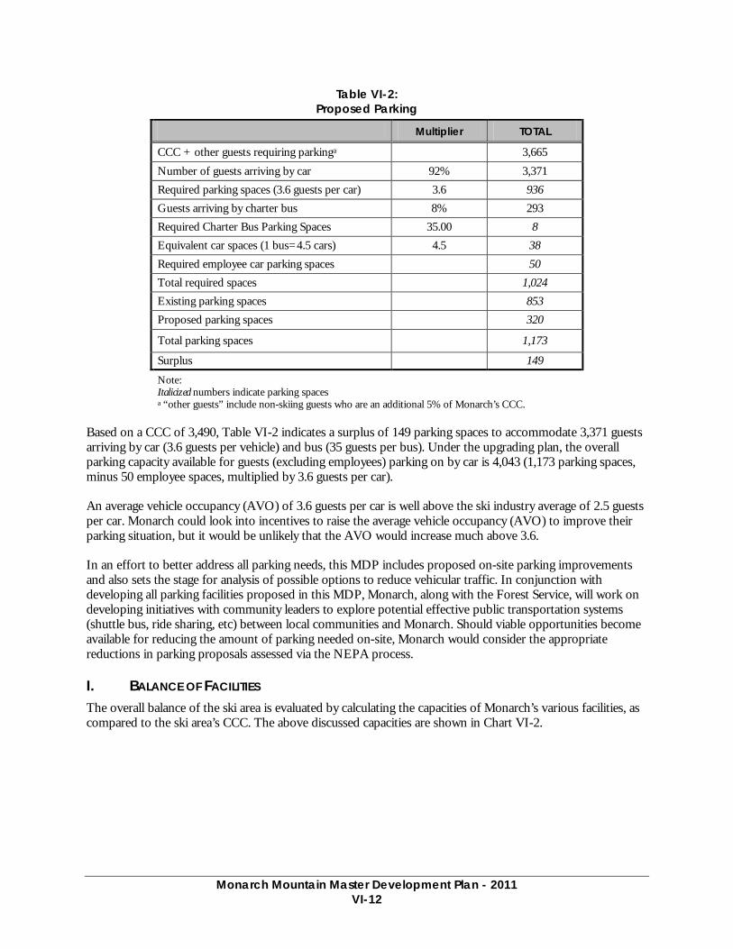
Monarch Mountain Master Development Plan - 2011
VI-12
Table VI-2: Proposed Parking
Multiplier TOTAL
CCC + other guests requiring parkinga 3,665
Number of guests arriving by car 92% 3,371 Required parking spaces (3.6 guests per car) 3.6 936 Guests arriving by charter bus 8% 293 Required Charter Bus Parking Spaces 35.00 8 Equivalent car spaces (1 bus=4.5 cars) 4.5 38 Required employee car parking spaces 50 Total required spaces 1,024 Existing parking spaces 853 Proposed parking spaces 320
Total parking spaces 1,173
Surplus 149
Note: Italicized numbers indicate parking spaces a “other guests” include non-skiing guests who are an additional 5% of Monarch’s CCC.
Based on a CCC of 3,490, Table VI-2 indicates a surplus of 149 parking spaces to accommodate 3,371 guests arriving by car (3.6 guests per vehicle) and bus (35 guests per bus). Under the upgrading plan, the overall parking capacity available for guests (excluding employees) parking on by car is 4,043 (1,173 parking spaces, minus 50 employee spaces, multiplied by 3.6 guests per car).
An average vehicle occupancy (AVO) of 3.6 guests per car is well above the ski industry average of 2.5 guests per car. Monarch could look into incentives to raise the average vehicle occupancy (AVO) to improve their parking situation, but it would be unlikely that the AVO would increase much above 3.6.
In an effort to better address all parking needs, this MDP includes proposed on-site parking improvements and also sets the stage for analysis of possible options to reduce vehicular traffic. In conjunction with developing all parking facilities proposed in this MDP, Monarch, along with the Forest Service, will work on developing initiatives with community leaders to explore potential effective public transportation systems (shuttle bus, ride sharing, etc) between local communities and Monarch. Should viable opportunities become available for reducing the amount of parking needed on-site, Monarch would consider the appropriate reductions in parking proposals assessed via the NEPA process.
I. BALANCE OF FACILITIES The overall balance of the ski area is evaluated by calculating the capacities of Monarch’s various facilities, as compared to the ski area’s CCC. The above discussed capacities are shown in Chart VI-2.
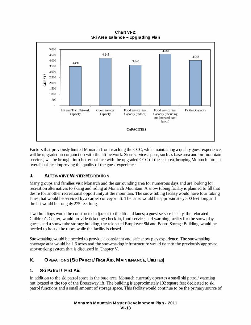
Monarch Mountain Master Development Plan - 2011
VI-13
Chart VI-2: Ski Area Balance – Upgrading Plan
Factors that previously limited Monarch from reaching the CCC, while maintaining a quality guest experience, will be upgraded in conjunction with the lift network. Skier services space, such as base area and on-mountain services, will be brought into better balance with the upgraded CCC of the ski area, bringing Monarch into an overall balance improving the quality of the guest experience.
J. ALTERNATIVE WINTER RECREATION Many groups and families visit Monarch and the surrounding area for numerous days and are looking for recreation alternatives to skiing and riding at Monarch Mountain. A snow tubing facility is planned to fill that desire for another recreational opportunity at the mountain. The snow tubing facility would have four tubing lanes that would be serviced by a carpet conveyor lift. The lanes would be approximately 500 feet long and the lift would be roughly 275 feet long.
Two buildings would be constructed adjacent to the lift and lanes; a guest service facility, the relocated Children’s Center, would provide ticketing/check-in, food service, and warming facility for the snow play guests and a snow tube storage building, the relocated Employee Ski and Board Storage Building, would be needed to house the tubes while the facility is closed.
Snowmaking would be needed to provide a consistent and safe snow play experience. The snowmaking coverage area would be 1.6 acres and the snowmaking infrastructure would tie into the previously approved snowmaking system that is discussed in Chapter V.
K. OPERATIONS (SKI PATROL/FIRST AID, MAINTENANCE, UTILITIES)
1. Ski Patrol / First Aid In addition to the ski patrol space in the base area, Monarch currently operates a small ski patrol/warming hut located at the top of the Breezeway lift. The building is approximately 192 square feet dedicated to ski patrol functions and a small amount of storage space. This facility would continue to be the primary source of
3,490
4,245
3,640
4,583
4,043
-
500
1,000
1,500
2,000
2,500
3,000
3,500
4,000
4,500
5,000
Lift and Trail Network Capacity
Guest Services Capacity
Food Service Seat Capacity (indoor)
Food Service Seat Capacity (including outdoor and sack
lunch)
Parking Capacity
GU
EST
S
CAPACITIES
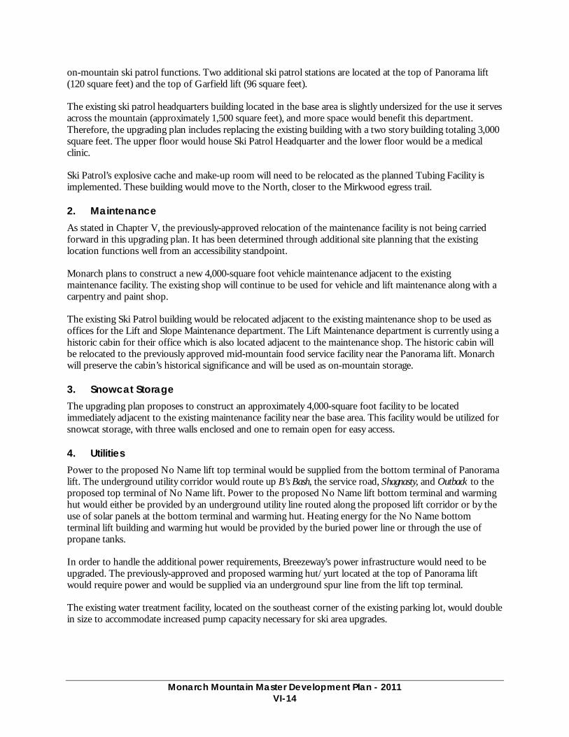
Monarch Mountain Master Development Plan - 2011
VI-14
on-mountain ski patrol functions. Two additional ski patrol stations are located at the top of Panorama lift (120 square feet) and the top of Garfield lift (96 square feet).
The existing ski patrol headquarters building located in the base area is slightly undersized for the use it serves across the mountain (approximately 1,500 square feet), and more space would benefit this department. Therefore, the upgrading plan includes replacing the existing building with a two story building totaling 3,000 square feet. The upper floor would house Ski Patrol Headquarter and the lower floor would be a medical clinic.
Ski Patrol’s explosive cache and make-up room will need to be relocated as the planned Tubing Facility is implemented. These building would move to the North, closer to the Mirkwood egress trail.
2. Maintenance As stated in Chapter V, the previously-approved relocation of the maintenance facility is not being carried forward in this upgrading plan. It has been determined through additional site planning that the existing location functions well from an accessibility standpoint.
Monarch plans to construct a new 4,000-square foot vehicle maintenance adjacent to the existing maintenance facility. The existing shop will continue to be used for vehicle and lift maintenance along with a carpentry and paint shop.
The existing Ski Patrol building would be relocated adjacent to the existing maintenance shop to be used as offices for the Lift and Slope Maintenance department. The Lift Maintenance department is currently using a historic cabin for their office which is also located adjacent to the maintenance shop. The historic cabin will be relocated to the previously approved mid-mountain food service facility near the Panorama lift. Monarch will preserve the cabin’s historical significance and will be used as on-mountain storage.
3. Snowcat Storage The upgrading plan proposes to construct an approximately 4,000-square foot facility to be located immediately adjacent to the existing maintenance facility near the base area. This facility would be utilized for snowcat storage, with three walls enclosed and one to remain open for easy access.
4. Utilities Power to the proposed No Name lift top terminal would be supplied from the bottom terminal of Panorama lift. The underground utility corridor would route up B’s Bash, the service road, Shagnasty, and Outback to the proposed top terminal of No Name lift. Power to the proposed No Name lift bottom terminal and warming hut would either be provided by an underground utility line routed along the proposed lift corridor or by the use of solar panels at the bottom terminal and warming hut. Heating energy for the No Name bottom terminal lift building and warming hut would be provided by the buried power line or through the use of propane tanks.
In order to handle the additional power requirements, Breezeway’s power infrastructure would need to be upgraded. The previously-approved and proposed warming hut/yurt located at the top of Panorama lift would require power and would be supplied via an underground spur line from the lift top terminal.
The existing water treatment facility, located on the southeast corner of the existing parking lot, would double in size to accommodate increased pump capacity necessary for ski area upgrades.

Monarch Mountain Master Development Plan - 2011
VI-15
5. Snow Storage The snow storage area located to the south of the existing Ski Patrol building is planned to be expanded by implementing a portion of the tree clearing that was previously approved for the snowmaking pond described in Chapter 5. The tree clearing would allow Monarch to make better use of this space as snow storage and therefore improving the parking lot utilization.
L. SUMMER RECREATION No summer recreation is proposed.

aaaaaaaaaaarrrrrrrrrrrrrrrrrrrrrrrrrrrrrrrrcccccrrrcccccccccccccccccccccrrrrrrrccccccccccccccccccchhhhhhhhhhhhhhhhhhhhhhhhhhhh
PPPPPPPPPPPP
Upgra
de to
C-3
SUP Boundary
SUP
Boun
dary
BREEZEW
AY
GARFIELD
PANORAMA
TUM
BELINA
PIONEER
No
Nam
e Li
ft
GladedSkiing
GladedSkiing
GladedSkiing
GladedSkiing
GladedSkiing
Gladed
Skiing
GladedSkiing
GladedSkiing
GladedSkiing
GladedSkiing
Food Service, Sun Deck,Food Service, Sun Deck,Composting Toilets,Composting Toilets,
and Relocated Cabinand Relocated Cabin
WarmingWarmingHutHut
Prev. ApprovedPrev. ApprovedMountain TopMountain Top
FacilityFacility
Prev. ApprovedMountain Top
Facility
WarmingHut
See Figure VI-2See Figure VI-2For Base Area DetailFor Base Area Detail
See Figure VI-2For Base Area Detail
Food Service, Sun Deck,Composting Toilets,
and Relocated Cabin
0 450 900 1,800’
25’ Contours in and adjacant to the SUP40’ Contours in No Name Basin
North
Prepared by:
PREVIOUSLYPREVIOUSLYAPPROVED ANDAPPROVED AND
PLANNED PROJECTSPLANNED PROJECTSFigure VI-1Figure VI-1
LEGEND
E x i s t i n gE x i s t i n gL i f tL i f t
P l a n n e d L i f tP l a n n e d L i f tU p g r a d eU p g r a d e
P l a n n e dP l a n n e dL i f tL i f t
S U PS U PB o u n d a r yB o u n d a r y
P l a n n e d S U PP l a n n e d S U PB o u n d a r yB o u n d a r y
E x i s t i n gE x i s t i n gB u i l d i n gB u i l d i n g
E x i s t i n gE x i s t i n gS k i Tr a i lS k i Tr a i l
Prev. ApprovedPrev. ApprovedS k i Tr a i lS k i Tr a i l
Prev. ApprovedPrev. ApprovedSnowmakingSnowmaking
PlannedPlannedSnowmakingSnowmaking
P l a n n e d S k iP l a n n e d S k iTrail and ClearingTrail and Clearing
Planned TerrainPlanned TerrainGradingGrading
Planned ThinningPlanned ThinningFor Gladed SkiingFor Gladed Skiing
Lift to be ConstructedLift to be Constructedin Summer 2011in Summer 2011
Prev. ApprovedPrev. ApprovedB u i l d i n gB u i l d i n g
R e l o c a t e dR e l o c a t e dB u i l d i n gB u i l d i n g
Master Development PlanMaster Development Plan
P l a n n e dP l a n n e dB u i l d i n gB u i l d i n g
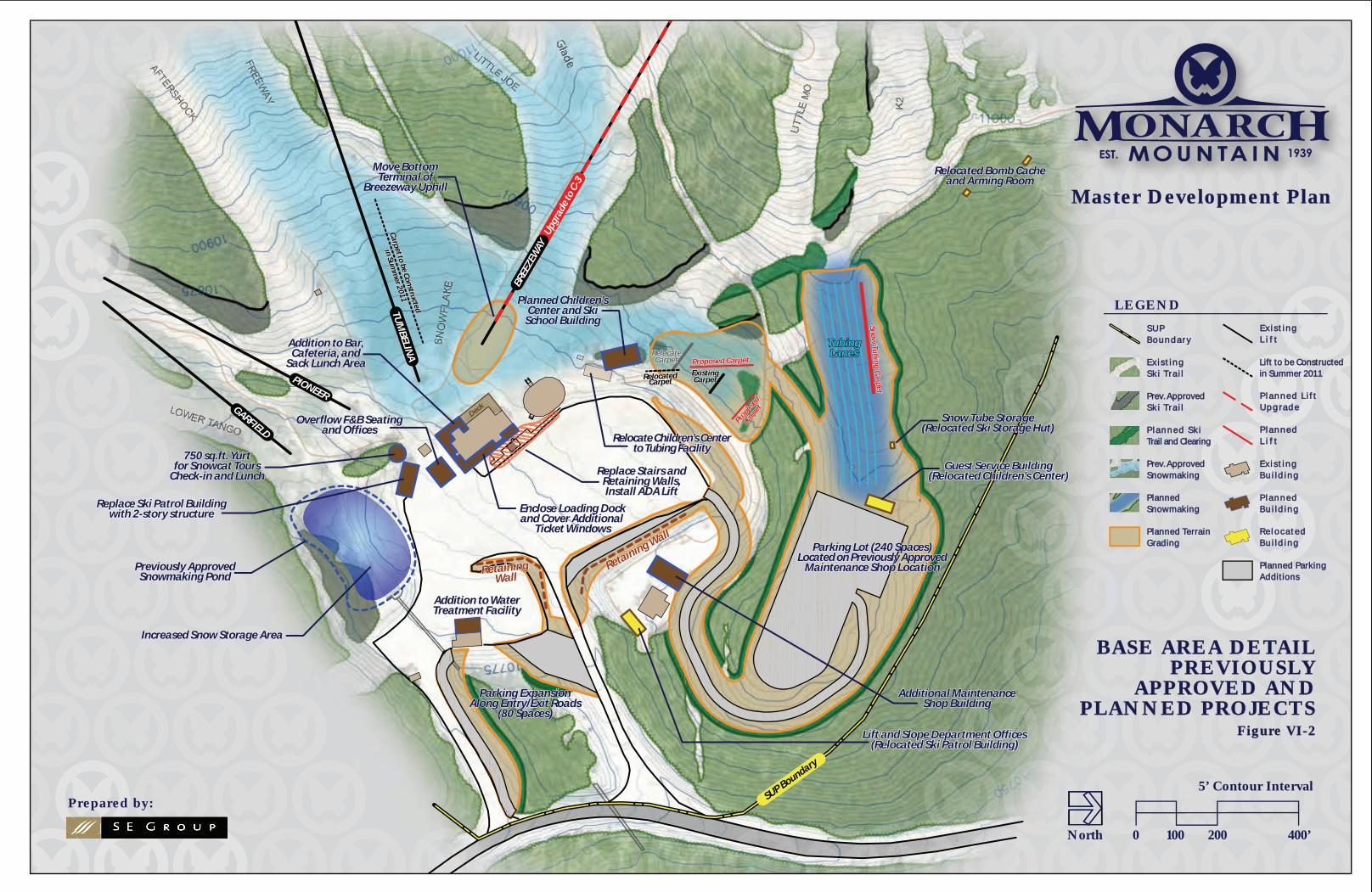
dddeeeGGladadadeeGlG aGGG
ddddeGlGlGladadadaadeeeGlGladadadeeeGlGladadadadGladaddddddeeeedddeee
Snow
Tub
ing
Ca
rpet
Snow
Tub
ing
Carp
et
Proposed CarpetProposed Carpet
Propose
d
Propose
dCarp
et
Carpet
Carpet to be Constructed
Carpet to be Constructed
in Summ
er 2011
in Summ
er 2011
Carpet to be Constructed
in Summ
er 2011
Upgra
de to
C-3
SUP Boundary
BREEZEW
AY
GARFIELD
TUM
BELINA
PIONEER
Addition to WaterAddition to WaterTreatment FacilityTreatment Facility
Additional MaintenanceAdditional MaintenanceShop BuildingShop Building
Additional MaintenanceShop Building
Parking ExpansionParking ExpansionAlong Entry/Exit RoadsAlong Entry/Exit Roads
(80 Spaces)(80 Spaces)
Move BottomMove BottomTerminal ofTerminal of
Breezeway UphillBreezeway Uphill
Proposed Carpet
Propose
dCarp
et
Snow
Tub
ing
Ca
rpet
Snow Tube StorageSnow Tube Storage(Relocated Ski Storage Hut)(Relocated Ski Storage Hut)
TubingTubingLanesLanes
TubingLanes
Increased Snow Storage AreaIncreased Snow Storage Area
Parking Lot (240 Spaces)Parking Lot (240 Spaces)Located on Previously ApprovedLocated on Previously Approved
Maintenance Shop LocationMaintenance Shop Location
Enclose Loading DockEnclose Loading Dock
Planned Children’sPlanned Children’sCenter and SkiCenter and Ski
School BuildingSchool Building
Addition to WaterTreatment Facility
Parking ExpansionAlong Entry/Exit Roads
(80 Spaces)
Move BottomTerminal of
Breezeway Uphill
Guest Service BuildingGuest Service Building(Relocated Children’s Center)(Relocated Children’s Center)
Guest Service Building(Relocated Children’s Center)
Addition to Bar,Addition to Bar,Cafeteria, andCafeteria, and
Sack Lunch AreaSack Lunch Area
Addition to Bar,Cafeteria, and
Sack Lunch Area
Overflow F&B SeatingOverflow F&B Seatingand Officesand Offices
Overflow F&B Seatingand Offices
Replace Ski Patrol BuildingReplace Ski Patrol Buildingwith 2-story structurewith 2-story structure
Replace Ski Patrol Buildingwith 2-story structure
750 sq.ft. Yurt750 sq.ft. Yurtfor Snowcat Toursfor Snowcat Tours
Check-in and LunchCheck-in and Lunch
Increased Snow Storage Area
Parking Lot (240 Spaces)Located on Previously Approved
Maintenance Shop Location
Enclose Loading DockEnclose Loading Dockand Cover Additional and Cover Additional
Ticket WindowsTicket Windows
Replace Stairs andRetaining Walls,Install ADA Lift
Enclose Loading Dockand Cover Additional
Ticket Windows
Relocate Children’s CenterRelocate Children’s Centerto Tubing Facilityto Tubing Facility
Relocate Children’s Centerto Tubing Facility
Planned Children’sCenter and Ski
School Building
Previously ApprovedPreviously ApprovedSnowmaking PondSnowmaking Pond
Previously ApprovedSnowmaking Pond
RelocateRelocateCarpetCarpet
RelocateCarpet
RelocatedRelocatedCarpetCarpet
RelocatedCarpet
ExistingExistingCarpetCarpet
ExistingCarpet
750 sq.ft. Yurtfor Snowcat Tours
Check-in and Lunch
Retaining Wall
Retaining Wall
RetainingRetainingWallWall
Retaining Wall
RetainingWall
Lift and Slope Department OfficesLift and Slope Department Offices(Relocated Ski Patrol Building)(Relocated Ski Patrol Building)
Lift and Slope Department Offices(Relocated Ski Patrol Building)
Snow Tube Storage(Relocated Ski Storage Hut)
Relocated Bomb CacheRelocated Bomb Cacheand Arming Roomand Arming Room
Relocated Bomb Cacheand Arming Room
0 100 200 400’
5’ Contour Interval
North
Prepared by:
BASE AREA DETAILBASE AREA DETAILPREVIOUSLYPREVIOUSLY
APPROVED ANDAPPROVED ANDPLANNED PROJECTSPLANNED PROJECTS
Figure VI-2Figure VI-2
LEGEND
E x i s t i n gE x i s t i n gL i f tL i f t
P l a n n e d L i f tP l a n n e d L i f tU p g r a d eU p g r a d e
P l a n n e dP l a n n e dL i f tL i f t
S U PS U PB o u n d a r yB o u n d a r y
E x i s t i n gE x i s t i n gB u i l d i n gB u i l d i n g
E x i s t i n gE x i s t i n gS k i Tr a i lS k i Tr a i l
Prev. ApprovedPrev. ApprovedS k i Tr a i lS k i Tr a i l
Prev. ApprovedPrev. ApprovedSnowmakingSnowmaking
PlannedPlannedSnowmakingSnowmaking
P l a n n e d S k iP l a n n e d S k iTrail and ClearingTrail and Clearing
Planned TerrainPlanned TerrainGradingGrading
Planned ParkingPlanned ParkingAdditionsAdditions
P l a n n e dP l a n n e dB u i l d i n gB u i l d i n g
Deck
Master Development PlanMaster Development Plan
Lift to be ConstructedLift to be Constructedin Summer 2011in Summer 2011
R e l o c a t e dR e l o c a t e dB u i l d i n gB u i l d i n g
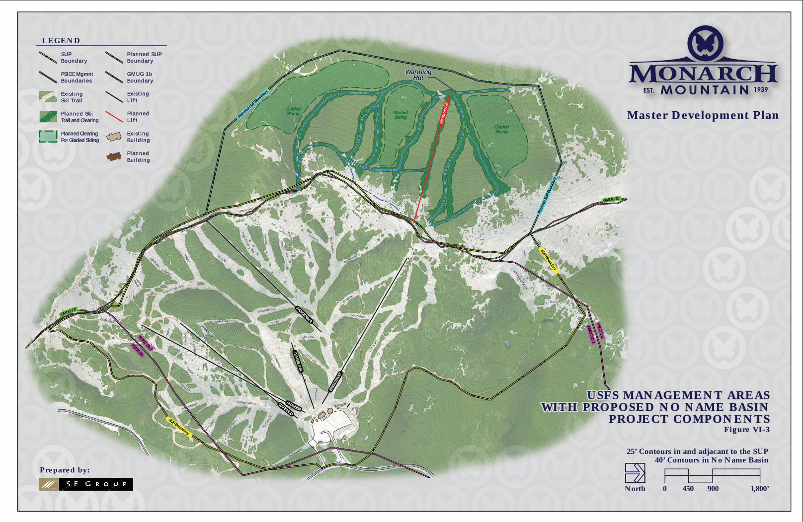
aaaaaaaaaaarrrrrrrrrrrrrrrrrrrrrrrrrrrrrrrrcccccrrrcccccccccccccccccccccrrrrrrrccccccccccccccccccchhhhhhhhhhhhhhhhhhhhhhhhhhhh
PPPPPPPPPPPP
SUP Boundary
BREEZEW
AY
GARFIELD
PANORAMA
TUM
BELINA
PIONEER
No
Nam
e Li
ft
WarmingWarmingHutHut
WarmingHut
SUP Boundary
Plan
ned
SUP
Boun
dary
Planned SUP Boundary
GMUG 1b
GMUG 1b
PSICC 1b-1
PSICC 2bPSICC 1b-1
PSICC 2b
GladedSkiing
GladedSkiing
GladedSkiing
0 450 900 1,800’
25’ Contours in and adjacant to the SUP40’ Contours in No Name Basin
North
Prepared by:
USFS MANAGEMENT AREASUSFS MANAGEMENT AREASWITH PROPOSED NO NAME BASINWITH PROPOSED NO NAME BASIN
PROJECT COMPONENTSPROJECT COMPONENTSFigure VI-3Figure VI-3
USFS MANAGEMENT AREASUSFS MANAGEMENT AREASWITH PROPOSED NO NAME BASINWITH PROPOSED NO NAME BASIN
PROJECT COMPONENTSPROJECT COMPONENTSFigure VI-3Figure VI-3
LEGEND
E x i s t i n gE x i s t i n gL i f tL i f t
P l a n n e dP l a n n e dL i f tL i f t
S U PS U PB o u n d a r yB o u n d a r y
P l a n n e d S U PP l a n n e d S U PB o u n d a r yB o u n d a r y
E x i s t i n gE x i s t i n gB u i l d i n gB u i l d i n g
E x i s t i n gE x i s t i n gS k i Tr a i lS k i Tr a i l
P l a n n e d S k iP l a n n e d S k iTrail and ClearingTrail and Clearing
Planned ClearingPlanned ClearingFor Gladed SkiingFor Gladed Skiing
P l a n n e dP l a n n e dB u i l d i n gB u i l d i n g
Master Development PlanMaster Development Plan
PSICC MgmntPSICC MgmntB o u n d a r i e sB o u n d a r i e s
G M U G 1 bG M U G 1 bB o u n d a r yB o u n d a r y
Chapter 7 Glossary

Monarch Mountain Master Development Plan - 2011
VII-1
VII. GLOSSARY
Ability Level: The relative rank of a skier or snowboarder, or the relative rank given to alpine terrain. The ten ability levels relied upon by SE Group are as follows: first-time beginner, beginner, advanced beginner, novice, low intermediate, intermediate, advanced intermediate, expert, advanced expert, and extreme.
Acceptable Trail Density: The maximum number of skiers and snowboarders that can slide on an acre of trail at any given time without causing uncomfortable crowding on the trail. Acceptable trail density is measured in skiers and snowboarders per acre. As a general rule, the difficulty of the trail and acceptable trail density share an inverse relationship.
Acre Foot: The amount of water, or snow, necessary to cover 1 acre to a depth of 1 foot.
Active Skiers and Snowboarders: Skiers and snowboarders are considered active if they are: (1) waiting in a lift line, (2) riding a lift, or (3) enjoying a downhill descent. Depending primarily upon weather and snow conditions, 70 to 85% of a resort’s skiers and snowboarders are active. The remaining 15 to 30% of a resort’s skiers and snowboarders are either using a resort’s support facilities and amenities or are circulating in a resort’s various staging and milling areas. These guests are considered non-active.
Alpine Comfortable Carrying Capacity (Alpine CCC): Alpine CCC is the comfortable, daily capacity of a resort’s skiing/snowboarding lifts. In short, Alpine CCC is derived from the supply of vertical transport (i.e., the combined uphill hourly capacities of the lifts) and the demand for vertical transport (i.e., the aggregate number of runs demanded multiplied by the vertical rise associated with those runs). In some instances, Alpine CCC is also called skiers-at-one-time (SAOT) capacity.
Best Management Practices (BMPs): Methods, measures, and practices specifically adopted for local conditions that deal effectively and practically with a given problem. BMPs include, but are not limited to, construction practices, structural and nonstructural controls, operations protocol, and maintenance procedures.
Comfortable Carrying Capacity: Comfortable Carrying Capacity (CCC) is a planning tool used to determine the optimum level of utilization that facilitates a pleasant recreational experience. This is a planning figure only and does not represent a regulatory cap on visitation. CCC is used to ensure that different aspects of a resort’s facilities are designed to work in harmony, that capacities are equivalent across facilities, and sufficient to meet anticipated demand. CCC is based on factors such as vertical transport and trail capacities.
Cubic Foot Per Second (cfs): The unit used to measure stream flow or similar discharge. One cfs is equivalent to 449 gallons per minute, or approximately 2 acre feet per day.
Day-Use Skier/Snowboarder: Generally speaking, a skier or snowboarder that lives within the resort’s day-use skier/snowboarder market. Given normal road and weather conditions, the day skier/snowboarder market is defined as the geographic area found within a 100-mile radius, or two-hour drive, of the resort. Day-use skiers and snowboarders drive to the resort and park in day-use lots.
Destination Skier/Snowboarder: Generally speaking, a skier or snowboarder that resides beyond a 250-mile, or five-hour, drive from the resort. On average, destination skiers and snowboarders stay at a resort for longer periods of time (i.e., ranging from three to seven days) and commonly comprise a majority of a resort’s mid-week visitation. Destination skiers/snowboarders typically rely
Monarch Mountain Master Development Plan - 2011
VII-2
upon air travel and shuttle service for transport to the resort, and obligate overnight lodging and numerous other resort amenities.
Detachable Grip Chairlift: An aerial tramway system on which chairs circulate around the system—alternately attaching and detaching from a moving haul rope. Chairlift detachment occurs at the lower and upper terminals for ease of lift loading and unloading.
Fall-Line: The path an object would naturally take as it descends a slope under the influence of gravity. Fall-line paths indicate the natural flow of potential trails, from the top of ridges to the elevations below. Fall-line terrain allows skiers and snowboarders to make equally weighted, left and right turns.
Fixed-Grip Chairlift: An aerial tramway system on which chairs remain attached to a haul rope.
Food Service Seat Turnover Rate: The turnover rate is used to evaluate a resort’s aggregate food service seating capacity. The turnover rate is the estimated number of times a food service seat is used during a resort’s peak food service operations. Sit-down dining at a resort lodge typically has a turnover rate of 3, while cafeteria-style dining is characterized by a turnover rate in the range of 4 to 5. In addition to the type of food service, a resort’s climate also impacts turnover rate (i.e., cold and snowy climates have lower turnover rates).
Formal Trail Network: The trails and other named terrain delineated on a resort’s trail map. In addition to traditional trail corridors, the network might include named and patrolled bowls, glades, chutes, couloirs, hike-to areas, and tree skiing/snowboarding areas.
Glading: The removal of a slope’s trees, which enables a tree stand to be skied or rode by a larger percentage of a resort’s guests. Varying degrees of tree removal can be conducted to achieve a positive guest experience, based on existing stand structure.
Gradient: The vertical distance divided by the horizontal distance (i.e., commonly known as “rise over run”), which is measured as a percent, or a degree. Slope gradient is used to determine the ability level distribution of a resort’s alpine terrain.
Guest Services Facilities or Guest Services: Facilities or services that are supplied by a resort to accommodate guests and enhance the quality of the recreational experience. Examples of guest services facilities include: restaurants, warming huts, general information desks, resort lost and found departments, restrooms and lounges, ski school, daycare, public lockers and ski-check facilities, ski patrol, first aid clinics, etc.
Halfpipe: A channel constructed in the snow, ranging from 75 to 400 feet long, with consistent 6- to 12-foot walls on both sides. The walls of the channel are contoured from horizontal to vertical and the bottom of the channel is generally flat.
Maze: A waiting area used to line up skiers and snowboarders just prior to lift loading (i.e., the corral area immediately adjacent to the loading point of the lift).
Mitigation: Actions taken to avoid, minimize, or compensate for adverse environmental impacts.
Morning Access Capacity: The resort’s capacity to carry skiers and snowboarders to other, up-mountain lifts within an acceptable time frame. By comparing the aggregate staging requirement for each access lift to the access lift’s uphill access capacity, the length of the access period for each access lift can be determined. Per industry standards, a destination resort should have dedicated access lifts (with sufficient hourly capacities) that supply the resort’s up-mountain lifts with guests
Monarch Mountain Master Development Plan - 2011
VII-3
(numbers commensurate with lift hourly capacities) within an access period ranging from 90 to 120 minutes.
Mountain Work Roads: On-mountain primary and secondary roads that provide summertime access (for rubber tire vehicles) to all mountain buildings and lift terminal locations.
National Environmental Policy Act of 1970 (NEPA): The federal act which requires federal agencies to prepare detailed reports on the environmental effects of proposed actions on public lands.
Off Fall-Line: The path an object takes as it crosses the fall-line slope. Off fall-line terrain compels skiers and snowboarders to make alternating long and short turns (turns that are not equally weighted) in order to accommodate the off fall-line condition. In some instances, and if properly designed, off fall-line terrain can be enjoyable to snowboarders.
Ollie Roll: A mound of snow, either naturally occurring or manmade, in the middle of a snowboard park that provides a jump or a hit. An ollie ranges from 3 to 6 feet in height and typically 10 feet in diameter.
Off-Piste: Alpine terrain not associated with a named and maintained ski trail.
Peak Day Carrying Capacity (PDCC): The anticipated visitation for holiday periods and for winter weekends with optimal snow and weather conditions (i.e., powder days). PDCC is estimated after a resort has established its Resort Comfortable Carrying Capacity (RCCC) threshold. In addition to RCCC, PDCC must reflect historic visitation records (i.e., the frequency with which attendance exceeds RCCC and the magnitude by which peak visitation exceeds RCCC). PDCC typically exceeds RCCC by anywhere from 105 to 150%.
Pod: A delineated parcel of land that, due to its favorable terrain characteristics, is suitable for lift and trail development. Pods are areas of relatively consistent terrain (both slope gradient and fall-line) that may be serviced by one or more lifts and may be easily integrated into the existing skier and snowboarder circulation patterns.
Prominent Ridge: The line of separation (i.e., a divide) between drainage basins.
Quad: A common abbreviation for a four-passenger chairlift.
Rider: A commonly used term for a snowboarding guest.
Round-Trip Interval (RTI): The round-trip interval represents the aggregate time spent waiting in the lift line, riding the lift, and skiing or riding a particular trail of the lift. The RTI is used to calculate the number of runs an average skier/snowboarder is expected to take on a particular lift over the course of a day. Ultimately, the RTI is used to calculate the daily vertical demand of an average skier/snowboarder.
Skier/Snowboarder Circulation Analysis: An on-slope survey in which skier and snowboarder circulation characteristics are recorded for the full spectrum of ability levels. The on-slope survey is performed for each lift, yielding an accurate determination of the lift’s average RTI and Alpine CCC.
Skiway: A trail that allows skiers and snowboarders to traverse the mountain and avoid additional chairlift rides. Skiways, or traverses, are also used in pods of intermediate, advanced intermediate, and expert terrain to provide an appropriate descent for guests of beginner and novice ability levels. A skiway is typically designed to maintain an average slope gradient of 10%.
Space Use Definitions
Monarch Mountain Master Development Plan - 2011
VII-4
• Administration All resort operations office space not already incorporated in the square footage totals for the service functions listed below.
• Bar/Lounge All serving and seating areas designated as restricted use for the serving and consumption of alcoholic beverages. If bar/lounge space is used for restaurant seating, these restricted seats should be included in the overall restaurant seat count.
• Circulation/Waste All circulation space and associated spaces, including hallways, stairwells, lobbies, elevators, etc.
• Daycare/Nursery Includes all daycare/nursery facilities, registration area, and lunch rooms associated with this function. Storage, employee lockers, restrooms, and administrative space directly associated with daycare/nursery should be included in this total. Areas associated with rental equipment should be included in the Rentals/Repair square footage total.
• Employee Lockers/Lounge All employee space not previously allocated to the other service functions listed under the space use definition section.
• Guest Services Services including general resort information desks and lost and found departments. The milling area beyond the information desks should be included in the guest services square footage total.
• Kitchen/Scramble The area where food preparation, food service, and food storage occurs. Employee lockers, employee restrooms, and administrative space directly associated with food services should be included in the kitchen/scramble square footage total.
• Mechanical All space designated to mechanical functions, including telephone rooms, furnace rooms, and space occupied by water heaters.
• Outdoor Deck Seats Included in restaurant seat count in some clement areas (e.g., resorts with a significant number of sunny, warm days), but not in areas of inclement weather.
• Public Lockers All public locker and changing rooms. Any public lockers located along the walls of circulation space should be included (add an additional 2 square feet of space per locker to account for space associated with locker use).
• Rentals/Repair All rental shops, repair services, and associated storage areas.
• Restaurant Seating All areas designated for food service seating, including restaurants, cafeterias, brown bag areas, and bar/lounge space dedicated to food service. Major circulation aisles through food service seating areas should be categorized as circulation space.
• Retail All retail shops and associated storage areas. Base area retail operations, as well as on-mountain outlets (selling sunscreen, sunglasses, goggles, hats, gloves, etc.), should be included in the retail square footage total.
• Ski Patrol Space associated with all first aid facilities and clinics. Storage, ski patrol lockers and restrooms, and administrative space directly associated with ski patrol should be included in the square footage total.
• Ski School Includes ski school registration area and any indoor staging areas. Storage, employee lockers, restrooms, and administrative space directly associated with ski school should be included in the ski school square footage total.
Monarch Mountain Master Development Plan - 2011
VII-5
• Storage All storage space not previously allocated to the other service functions listed under the space use definition section.
• Ticket Sales The space associated with ticketing and season pass sales and associated administrative space. Exterior milling areas associated with ticket sales should not be included in this total. Interior milling areas should be categorized as circulation space.
• Staging: An area, or zone, where guests assemble and are prepared for a particular recreational pursuit. Examples of staging areas include milling and maze areas, check-in and guest drop-off areas, plazas, etc.
• Surface Lift: A lift on which passengers are propelled by means of a circulating overhead wire rope while remaining in contact with the snow surface. Connection between the overhead wire and the passenger is by means of a towing device (e.g., T-bar, J-bar, platter, etc.) attached and circulating with the lift’s haul rope. (Note: For definitional purposes, conveyor and belt lifts are considered surface lifts.)
• Table Top: A mound of snow on the slope that is cut flat on the top providing a place for snowboarders to land on top or jump over.
• Terrain Park: An area dedicated to the development and maintenance of a collection of alternative terrain features, which may include, but is not limited to, elements like halfpipes, quarterpipes, big air hits, ollies, spines, jibbing elements, barrel bonks, table tops, etc.
• Trail Density Per Acre: The number of skiers and snowboarders that occupy an acre of trail at any one given time. Trail density is reported in a persons-per-acre ratio.
• Uphill Hourly Capacity: A calculation of the number of skiers and snowboarders transported—per hour—from the lower to the upper terminal of the lift. A resort’s combined uphill hourly capacity is the aggregation of the resort’s individual lift capacities.
• Vertical Demand: The vertical demand of a lift is the by-product of the lift’s vertical rise, the average round-trip interval (i.e., number of runs per hour), and the number of hours the lift is used by an average skier or snowboarder. In short, vertical demand is the product of the lift’s vertical rise and the number of runs skied/rode in a day of typical operation.
• Vertical Transport Feet per Hour (VTF/hr.) (000): The number of persons a lift is able to transport 1,000 vertical feet in 1 hour. VTF/hour is derived by multiplying a lift’s uphill capacity (measured in persons per hour) by the lift’s vertical rise (measured in feet) and dividing by 1,000.

Appendix A
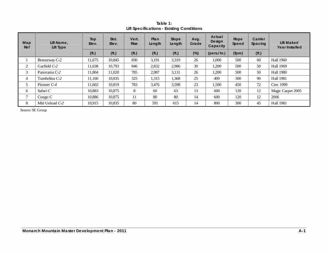
Monarch Mountain Master Development Plan - 2011 A-1
Table 1:
Lift Specifications - Existing Conditions
Map Ref
Lift Name, Lift Type
Top Elev.
Bot. Elev.
Vert. Rise
Plan Length
Slope Length
Avg. Grade
Actual Design
Capacity
Rope Speed
Carrier Spacing Lift Maker/
Year Installed (ft.) (ft.) (ft.) (ft.) (ft.) (%) (pers./hr.) (fpm) (ft.)
1 Breezeway C-2 11,675 10,845 830 3,191 3,319 26 1,000 500 60 Hall 1960 2 Garfield C-2 11,638 10,793 846 2,832 2,986 30 1,200 500 50 Hall 1969 3 Panorama C-2 11,804 11,020 785 2,987 3,131 26 1,200 500 50 Hall 1980 4 Tumbelina C-2 11,160 10,835 325 1,315 1,368 25 400 300 90 Hall 1981 5 Pioneer C-4 11,602 10,819 783 3,476 3,598 23 1,500 450 72 Ctec 1999 6 Safari C 10,883 10,875 8 60 63 13 600 120 12 Magic Carpet 2005 7 Congo C 10,886 10,875 11 80 80 14 600 120 12 2006 8 Mid Unload C-2 10,915 10,835 80 591 615 14 800 300 45 Hall 1981
Source: SE Group

Monarch Mountain Master Development Plan - 2011 A-2
Table 2:
Lift Specifications - Upgrade Plan
Map Ref
Lift Name, Lift Type
Top Elev.
Bot. Elev.
Vert. Rise
Plan Length
Slope Length
Avg. Grade
Actual Design
Capacity
Rope Speed
Carrier Spacing Lift Maker/
Year Installed (ft.) (ft.) (ft.) (ft.) (ft.) (%) (pers./hr.) (fpm) (ft.)
1 Shortened and Upgraded Breezeway C-3 11,675 10,840 835 3,080 3,203 26 2,000 500 60 New
2 Garfield C-2 11,638 10,793 846 2,832 2,986 30 1,200 500 50 Hall 1969 3 Panorama C-2 11,804 11,020 785 2,987 3,131 26 1,200 500 50 Hall 1980 4 Tumbelina C-2 11,160 10,835 325 1,315 1,368 25 1,200 400 40 Hall 1981 5 Pioneer C-4 11,602 10,819 783 3,476 3,598 23 1,800 450 60 Ctec 1999 8 Proposed No Name C-2 11,700 10,740 960 2,550 2,725 37 1,200 500 50 New 9 Snowflake Carpet 10,894 10,843 51 450 453 14 400 120 18 New 6 Safari C 10,878 10,873 5 60 60 10 600 120 12 Magic Carpet 2005 7 Proposed Carpet III C 10,893 10,875 18 150 151 12 600 120 12 2006 10 Congo C 10,882 10,874 8 80 80 8 400 120 18 New 11 Proposed Carpet IV C 10,882 10,874 8 80 80 10 400 120 18 New
Legend: Existing, Upgraded/Modified Lifts New, Proposed Lifts Previously Approved Lift, to be installed in Summer 2011
Source: SE Group
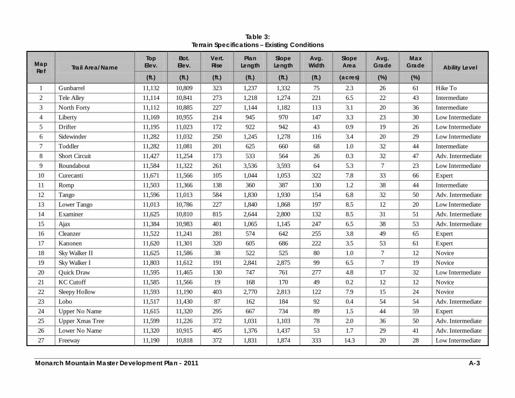
Monarch Mountain Master Development Plan - 2011 A-3
Table 3:
Terrain Specifications – Existing Conditions
Map Ref Trail Area/Name
Top Elev.
Bot. Elev.
Vert. Rise
Plan Length
Slope Length
Avg. Width
Slope Area
Avg. Grade
Max Grade Ability Level
(ft.) (ft.) (ft.) (ft.) (ft.) (ft.) (acres) (%) (%)
1 Gunbarrel 11,132 10,809 323 1,237 1,332 75 2.3 26 61 Hike To 2 Tele Alley 11,114 10,841 273 1,218 1,274 221 6.5 22 43 Intermediate 3 North Forty 11,112 10,885 227 1,144 1,182 113 3.1 20 36 Intermediate 4 Liberty 11,169 10,955 214 945 970 147 3.3 23 30 Low Intermediate 5 Drifter 11,195 11,023 172 922 942 43 0.9 19 26 Low Intermediate 6 Sidewinder 11,282 11,032 250 1,245 1,278 116 3.4 20 29 Low Intermediate 7 Toddler 11,282 11,081 201 625 660 68 1.0 32 44 Intermediate 8 Short Circuit 11,427 11,254 173 533 564 26 0.3 32 47 Adv. Intermediate 9 Roundabout 11,584 11,322 261 3,536 3,593 64 5.3 7 23 Low Intermediate 10 Curecanti 11,671 11,566 105 1,044 1,053 322 7.8 33 66 Expert 11 Romp 11,503 11,366 138 360 387 130 1.2 38 44 Intermediate 12 Tango 11,596 11,013 584 1,830 1,930 154 6.8 32 50 Adv. Intermediate 13 Lower Tango 11,013 10,786 227 1,840 1,868 197 8.5 12 20 Low Intermediate 14 Examiner 11,625 10,810 815 2,644 2,800 132 8.5 31 51 Adv. Intermediate 15 Ajax 11,384 10,983 401 1,065 1,145 247 6.5 38 53 Adv. Intermediate 16 Cleanzer 11,522 11,241 281 574 642 255 3.8 49 65 Expert 17 Kanonen 11,620 11,301 320 605 686 222 3.5 53 61 Expert 18 Sky Walker II 11,625 11,586 38 522 525 80 1.0 7 12 Novice 19 Sky Walker I 11,803 11,612 191 2,841 2,875 99 6.5 7 19 Novice 20 Quick Draw 11,595 11,465 130 747 761 277 4.8 17 32 Low Intermediate 21 KC Cutoff 11,585 11,566 19 168 170 49 0.2 12 12 Novice 22 Sleepy Hollow 11,593 11,190 403 2,770 2,813 122 7.9 15 24 Novice 23 Lobo 11,517 11,430 87 162 184 92 0.4 54 54 Adv. Intermediate 24 Upper No Name 11,615 11,320 295 667 734 89 1.5 44 59 Expert 25 Upper Xmas Tree 11,599 11,226 372 1,031 1,103 78 2.0 36 50 Adv. Intermediate 26 Lower No Name 11,320 10,915 405 1,376 1,437 53 1.7 29 41 Adv. Intermediate 27 Freeway 11,190 10,818 372 1,831 1,874 333 14.3 20 28 Low Intermediate
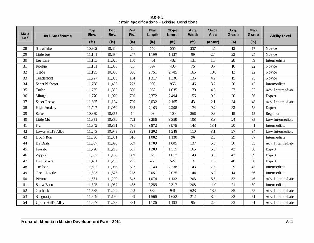
Monarch Mountain Master Development Plan - 2011 A-4
Table 3: Terrain Specifications – Existing Conditions
Map Ref Trail Area/Name
Top Elev.
Bot. Elev.
Vert. Rise
Plan Length
Slope Length
Avg. Width
Slope Area
Avg. Grade
Max Grade Ability Level
(ft.) (ft.) (ft.) (ft.) (ft.) (ft.) (acres) (%) (%)
28 Snowflake 10,902 10,834 68 550 555 357 4.5 12 17 Novice 29 Little Joe 11,141 10,894 247 1,109 1,137 90 2.4 22 25 Novice 30 Bee Line 11,153 11,023 130 461 482 131 1.5 28 39 Intermediate 31 Rookie 11,151 11,088 63 397 403 75 0.7 16 22 Novice 32 Glade 11,195 10,838 356 2,751 2,785 165 10.6 13 22 Novice 33 Tenderfoot 11,227 11,033 194 1,317 1,336 136 4.2 15 25 Novice 34 Short N Sweet 11,708 11,435 273 908 953 146 3.2 30 45 Intermediate 35 Turbo 11,755 11,395 360 966 1,035 170 4.0 37 53 Adv. Intermediate 36 Mirage 11,770 11,070 700 2,372 2,494 156 9.0 30 56 Expert 37 Sheer Rocko 11,805 11,104 700 2,032 2,165 43 2.1 34 48 Adv. Intermediate 38 High Anxiety 11,747 11,059 688 2,163 2,298 174 9.2 32 58 Expert 39 Safari 10,869 10,855 14 98 100 266 0.6 15 15 Beginner 40 Little Mo 11,651 10,859 792 3,256 3,359 108 8.3 24 35 Low Intermediate 41 K2 11,672 10,891 781 3,872 3,975 143 13.1 20 41 Intermediate 42 Lower Hall’s Alley 11,273 10,945 328 1,202 1,248 110 3.1 27 34 Low Intermediate 43 Doc’s Run 11,396 11,081 316 1,082 1,130 96 2.5 29 37 Intermediate 44 B’s Bash 11,567 11,028 539 1,789 1,885 137 5.9 30 53 Adv. Intermediate 45 Frazzle 11,720 11,215 505 1,203 1,315 165 5.0 42 58 Expert 46 Zipper 11,557 11,158 399 926 1,017 143 3.3 43 59 Expert 47 Dire Straits 11,481 11,255 225 468 522 131 1.6 48 60 Expert 48 Ticaboo 11,692 11,066 627 2,140 2,238 143 7.3 29 45 Intermediate 49 Great Divide 11,803 11,525 278 2,051 2,075 144 6.9 14 36 Intermediate 50 Picante 11,551 11,209 342 1,074 1,132 203 5.3 32 46 Adv. Intermediate 51 Snow Burn 11,525 11,057 468 2,255 2,317 208 11.0 21 39 Intermediate 52 Outback 11,535 11,242 293 889 941 623 13.5 35 55 Adv. Intermediate 53 Shagnasty 11,649 11,150 499 1,566 1,652 212 8.0 32 51 Adv. Intermediate 54 Upper Hall’s Alley 11,667 11,293 374 1,126 1,193 95 2.6 33 51 Adv. Intermediate

Monarch Mountain Master Development Plan - 2011 A-5
Table 3: Terrain Specifications – Existing Conditions
Map Ref Trail Area/Name
Top Elev.
Bot. Elev.
Vert. Rise
Plan Length
Slope Length
Avg. Width
Slope Area
Avg. Grade
Max Grade Ability Level
(ft.) (ft.) (ft.) (ft.) (ft.) (ft.) (acres) (%) (%)
55 Geno’s Meadow 11,273 11,010 264 790 835 452 8.7 33 46 Adv. Intermediate 56 Tumbelina Lift Line 11,157 10,932 225 647 688 89 1.4 35 37 Intermediate 57 Mirkwood Basin 11,925 11,175 750 3,000 3,186 1,888 138.1 25 67 Hike To 58 Mirkwood Basin Egress 11,175 11,000 175 2,400 2,429 53 2.9 7 65 Hike To
TOTAL 83,660 413.5
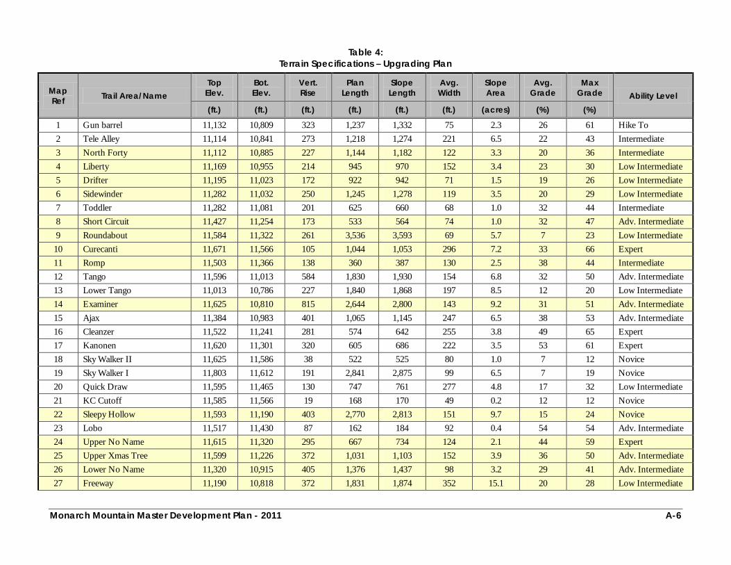
Monarch Mountain Master Development Plan - 2011 A-6
Table 4:
Terrain Specifications – Upgrading Plan
Map Ref Trail Area/Name
Top Elev.
Bot. Elev.
Vert. Rise
Plan Length
Slope Length
Avg. Width
Slope Area
Avg. Grade
Max Grade Ability Level
(ft.) (ft.) (ft.) (ft.) (ft.) (ft.) (acres) (%) (%)
1 Gun barrel 11,132 10,809 323 1,237 1,332 75 2.3 26 61 Hike To 2 Tele Alley 11,114 10,841 273 1,218 1,274 221 6.5 22 43 Intermediate 3 North Forty 11,112 10,885 227 1,144 1,182 122 3.3 20 36 Intermediate 4 Liberty 11,169 10,955 214 945 970 152 3.4 23 30 Low Intermediate 5 Drifter 11,195 11,023 172 922 942 71 1.5 19 26 Low Intermediate 6 Sidewinder 11,282 11,032 250 1,245 1,278 119 3.5 20 29 Low Intermediate 7 Toddler 11,282 11,081 201 625 660 68 1.0 32 44 Intermediate 8 Short Circuit 11,427 11,254 173 533 564 74 1.0 32 47 Adv. Intermediate 9 Roundabout 11,584 11,322 261 3,536 3,593 69 5.7 7 23 Low Intermediate 10 Curecanti 11,671 11,566 105 1,044 1,053 296 7.2 33 66 Expert 11 Romp 11,503 11,366 138 360 387 130 2.5 38 44 Intermediate 12 Tango 11,596 11,013 584 1,830 1,930 154 6.8 32 50 Adv. Intermediate 13 Lower Tango 11,013 10,786 227 1,840 1,868 197 8.5 12 20 Low Intermediate 14 Examiner 11,625 10,810 815 2,644 2,800 143 9.2 31 51 Adv. Intermediate 15 Ajax 11,384 10,983 401 1,065 1,145 247 6.5 38 53 Adv. Intermediate 16 Cleanzer 11,522 11,241 281 574 642 255 3.8 49 65 Expert 17 Kanonen 11,620 11,301 320 605 686 222 3.5 53 61 Expert 18 Sky Walker II 11,625 11,586 38 522 525 80 1.0 7 12 Novice 19 Sky Walker I 11,803 11,612 191 2,841 2,875 99 6.5 7 19 Novice 20 Quick Draw 11,595 11,465 130 747 761 277 4.8 17 32 Low Intermediate 21 KC Cutoff 11,585 11,566 19 168 170 49 0.2 12 12 Novice 22 Sleepy Hollow 11,593 11,190 403 2,770 2,813 151 9.7 15 24 Novice 23 Lobo 11,517 11,430 87 162 184 92 0.4 54 54 Adv. Intermediate 24 Upper No Name 11,615 11,320 295 667 734 124 2.1 44 59 Expert 25 Upper Xmas Tree 11,599 11,226 372 1,031 1,103 152 3.9 36 50 Adv. Intermediate 26 Lower No Name 11,320 10,915 405 1,376 1,437 98 3.2 29 41 Adv. Intermediate 27 Freeway 11,190 10,818 372 1,831 1,874 352 15.1 20 28 Low Intermediate
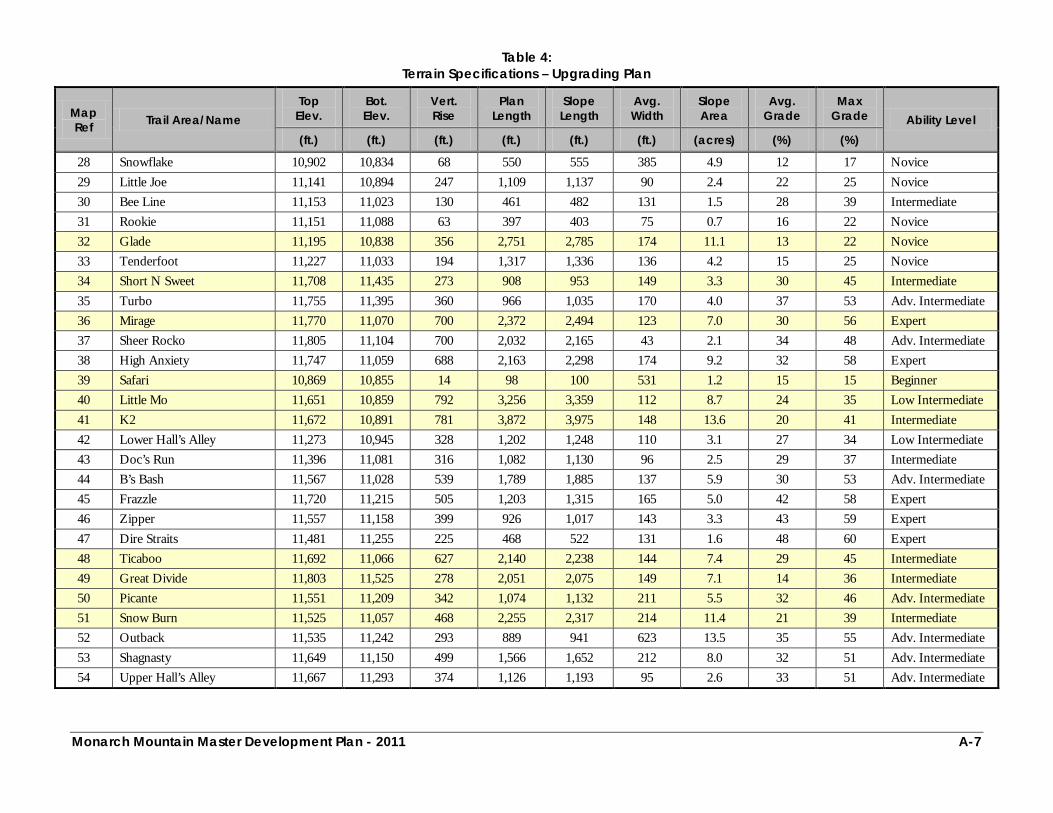
Monarch Mountain Master Development Plan - 2011 A-7
Table 4: Terrain Specifications – Upgrading Plan
Map Ref Trail Area/Name
Top Elev.
Bot. Elev.
Vert. Rise
Plan Length
Slope Length
Avg. Width
Slope Area
Avg. Grade
Max Grade Ability Level
(ft.) (ft.) (ft.) (ft.) (ft.) (ft.) (acres) (%) (%)
28 Snowflake 10,902 10,834 68 550 555 385 4.9 12 17 Novice 29 Little Joe 11,141 10,894 247 1,109 1,137 90 2.4 22 25 Novice 30 Bee Line 11,153 11,023 130 461 482 131 1.5 28 39 Intermediate 31 Rookie 11,151 11,088 63 397 403 75 0.7 16 22 Novice 32 Glade 11,195 10,838 356 2,751 2,785 174 11.1 13 22 Novice 33 Tenderfoot 11,227 11,033 194 1,317 1,336 136 4.2 15 25 Novice 34 Short N Sweet 11,708 11,435 273 908 953 149 3.3 30 45 Intermediate 35 Turbo 11,755 11,395 360 966 1,035 170 4.0 37 53 Adv. Intermediate 36 Mirage 11,770 11,070 700 2,372 2,494 123 7.0 30 56 Expert 37 Sheer Rocko 11,805 11,104 700 2,032 2,165 43 2.1 34 48 Adv. Intermediate 38 High Anxiety 11,747 11,059 688 2,163 2,298 174 9.2 32 58 Expert 39 Safari 10,869 10,855 14 98 100 531 1.2 15 15 Beginner 40 Little Mo 11,651 10,859 792 3,256 3,359 112 8.7 24 35 Low Intermediate 41 K2 11,672 10,891 781 3,872 3,975 148 13.6 20 41 Intermediate 42 Lower Hall’s Alley 11,273 10,945 328 1,202 1,248 110 3.1 27 34 Low Intermediate 43 Doc’s Run 11,396 11,081 316 1,082 1,130 96 2.5 29 37 Intermediate 44 B’s Bash 11,567 11,028 539 1,789 1,885 137 5.9 30 53 Adv. Intermediate 45 Frazzle 11,720 11,215 505 1,203 1,315 165 5.0 42 58 Expert 46 Zipper 11,557 11,158 399 926 1,017 143 3.3 43 59 Expert 47 Dire Straits 11,481 11,255 225 468 522 131 1.6 48 60 Expert 48 Ticaboo 11,692 11,066 627 2,140 2,238 144 7.4 29 45 Intermediate 49 Great Divide 11,803 11,525 278 2,051 2,075 149 7.1 14 36 Intermediate 50 Picante 11,551 11,209 342 1,074 1,132 211 5.5 32 46 Adv. Intermediate 51 Snow Burn 11,525 11,057 468 2,255 2,317 214 11.4 21 39 Intermediate 52 Outback 11,535 11,242 293 889 941 623 13.5 35 55 Adv. Intermediate 53 Shagnasty 11,649 11,150 499 1,566 1,652 212 8.0 32 51 Adv. Intermediate 54 Upper Hall’s Alley 11,667 11,293 374 1,126 1,193 95 2.6 33 51 Adv. Intermediate
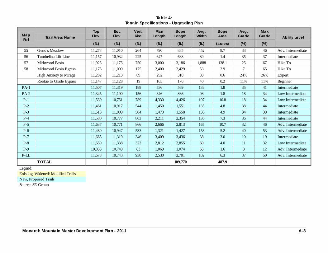
Monarch Mountain Master Development Plan - 2011 A-8
Table 4: Terrain Specifications – Upgrading Plan
Map Ref Trail Area/Name
Top Elev.
Bot. Elev.
Vert. Rise
Plan Length
Slope Length
Avg. Width
Slope Area
Avg. Grade
Max Grade Ability Level
(ft.) (ft.) (ft.) (ft.) (ft.) (ft.) (acres) (%) (%)
55 Geno’s Meadow 11,273 11,010 264 790 835 452 8.7 33 46 Adv. Intermediate 56 Tumbelina Lift Line 11,157 10,932 225 647 688 89 1.4 35 37 Intermediate 57 Mirkwood Basin 11,925 11,175 750 3,000 3,186 1,888 138.1 25 67 Hike To 58 Mirkwood Basin Egress 11,175 11,000 175 2,400 2,429 53 2.9 7 65 Hike To High Anxiety to Mirage 11,282 11,213 69 292 310 83 0.6 24% 26% Expert Rookie to Glade Bypass 11,147 11,128 19 165 170 40 0.2 11% 11% Beginner
PA-1 11,507 11,319 188 536 569 138 1.8 35 41 Intermediate PA-2 11,345 11,190 156 846 866 93 1.8 18 34 Low Intermediate P-1 11,539 10,751 789 4,330 4,426 107 10.8 18 34 Low Intermediate P-2 11,461 10,917 544 1,450 1,551 135 4.8 38 44 Intermediate P-3 11,513 11,009 504 1,473 1,558 136 4.9 34 39 Intermediate P-4 11,580 10,777 803 2,211 2,354 136 7.3 36 44 Intermediate P-5 11,637 10,771 866 2,666 2,813 165 10.7 32 46 Adv. Intermediate P-6 11,480 10,947 533 1,321 1,427 158 5.2 40 53 Adv. Intermediate P-7 11,665 11,319 346 3,409 3,436 38 3.0 10 19 Intermediate P-8 11,659 11,338 322 2,812 2,855 60 4.0 11 32 Low Intermediate P-9 10,833 10,749 83 1,069 1,074 65 1.6 8 12 Adv. Intermediate
P-LL 11,673 10,743 930 2,530 2,701 102 6.3 37 50 Adv. Intermediate
TOTAL 109,770 487.9 Legend: Existing, Widened/Modified Trails New, Proposed Trails Source: SE Group

Monarch Mountain Master Development Plan - 2011 A-9
Table 5:
Daily Lift Capacity – CCC – Existing Conditions
Map Ref.
Lift Name, Lift Type
Slope Length
Vertical Rise
Actual Design
Capacity
Oper. Hours
Up-Mtn. Access
Role
Misloading/ Lift
Stoppages
Adjusted Hourly Cap. VTF/Day Vertical
Demand
Daily Lift
Capacity
(ft.) (ft.) (guests/hr.) (hrs.) (%) (%) (guests/hr.) (000) (ft./day) (guests)
1 Breezeway C-2 3,319 830 1,000 7.00 - 10 900 5,229 15,431 340 2 Garfield C-2 2,986 846 1,200 7.00 - 10 1,080 6,394 13,545 470 3 Panorama C-2 3,131 785 1,200 6.75 - 10 1,080 5,720 8,283 690 4 Tumbelina C-2 1,368 325 400 7.00 15 10 300 682 3,613 190 5 Pioneer C-4 3,598 783 1,500 7.00 10 5 1,275 6,988 9,268 750 6 Safari C 63 8 600 7.00 - 5 570 32 685 50 7 Congo C 84 11 600 7.00 - 5 570 44 860 50 8 Mid Unload C-2 615 80 800 7.00 - 15 680 381 1,146 330
TOTAL 15,164 7,300 6,455 25,470 2,870
Source: SE Group
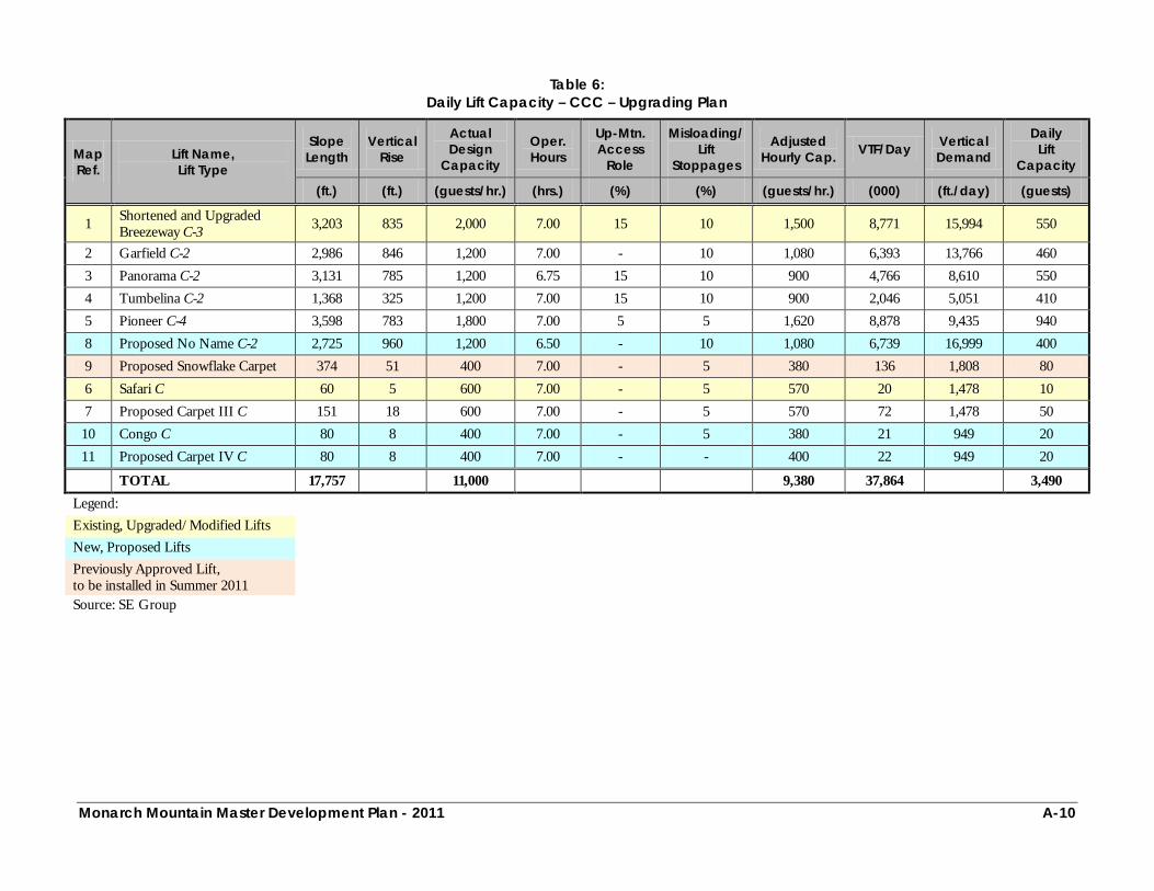
Monarch Mountain Master Development Plan - 2011 A-10
Table 6:
Daily Lift Capacity – CCC – Upgrading Plan
Map Ref.
Lift Name, Lift Type
Slope Length
Vertical Rise
Actual Design
Capacity
Oper. Hours
Up-Mtn. Access
Role
Misloading/ Lift
Stoppages
Adjusted Hourly Cap. VTF/Day Vertical
Demand
Daily Lift
Capacity
(ft.) (ft.) (guests/hr.) (hrs.) (%) (%) (guests/hr.) (000) (ft./day) (guests)
1 Shortened and Upgraded Breezeway C-3 3,203 835 2,000 7.00 15 10 1,500 8,771 15,994 550
2 Garfield C-2 2,986 846 1,200 7.00 - 10 1,080 6,393 13,766 460 3 Panorama C-2 3,131 785 1,200 6.75 15 10 900 4,766 8,610 550 4 Tumbelina C-2 1,368 325 1,200 7.00 15 10 900 2,046 5,051 410 5 Pioneer C-4 3,598 783 1,800 7.00 5 5 1,620 8,878 9,435 940 8 Proposed No Name C-2 2,725 960 1,200 6.50 - 10 1,080 6,739 16,999 400 9 Proposed Snowflake Carpet 374 51 400 7.00 - 5 380 136 1,808 80 6 Safari C 60 5 600 7.00 - 5 570 20 1,478 10 7 Proposed Carpet III C 151 18 600 7.00 - 5 570 72 1,478 50 10 Congo C 80 8 400 7.00 - 5 380 21 949 20 11 Proposed Carpet IV C 80 8 400 7.00 - - 400 22 949 20
TOTAL 17,757 11,000 9,380 37,864 3,490 Legend: Existing, Upgraded/Modified Lifts New, Proposed Lifts Previously Approved Lift, to be installed in Summer 2011
Source: SE Group

Monarch Mountain Master Development Plan - 2011 A-11
Table 7:
Density Analysis – Existing Conditions
Map Reference Daily Lift Capacity
Guest Dispersal Density Analysis Density Index Support
Fac./Milling Lift
Lines On Lift
On Terrain
Terrain Area
Terrain Density
Desired Trail Density Diff.
(guests) (guests) (guests) (guests) (acres) (guests/ac.) (guests/ac.) (+/-) (%)
Breezeway C-2 340 85 45 100 110 206.8 1 3 -2 33 Garfield C-2 470 118 126 108 118 71.3 2 10 -8 20 Panorama C-2 690 173 126 113 278 91.9 3 8 -5 38 Tumbelina C-2 190 48 60 23 59 7.8 8 14 -6 57 Pioneer C-4 750 188 149 170 243 30.2 8 14 -6 57 Mid Unload C-2 330 83 136 23 88 4.1 21 18 3 117
TOTAL 2,770 695 642 537 896 412.1 6 11 -5 59
Source: SE Group

Monarch Mountain Master Development Plan - 2011 A-12
Table 8:
Density Analysis – Upgrading Plan
Map Reference Daily Lift Capacity
Guest Dispersal Density Analysis Density Index Support
Fac./Milling Lift
Lines On Lift
On Terrain
Terrain Area
Terrain Density
Desired Trail Density Diff.
(guests) (guests) (guests) (guests) (acres) (guests/ac.) (guests/ac.) (+/-) (%)
Shortened and Upgraded Breezeway C-3 550 138 75 160 177 207.5 1 3 -2 33
Garfield C-2 460 115 126 108 111 78.6 1 10 -9 10 Panorama C-2 550 138 105 94 213 104.9 2 9 -7 22 Tumbelina C-2 410 103 105 51 151 8.7 17 14 3 121 Pioneer C-4 940 235 189 216 300 34.0 9 14 -5 64 Proposed No Name C-2 400 100 72 98 130 47.8 3 9 -6 33
TOTAL 3,310 829 672 727 1,082 481.5 6 10 -5 56
Source: SE Group
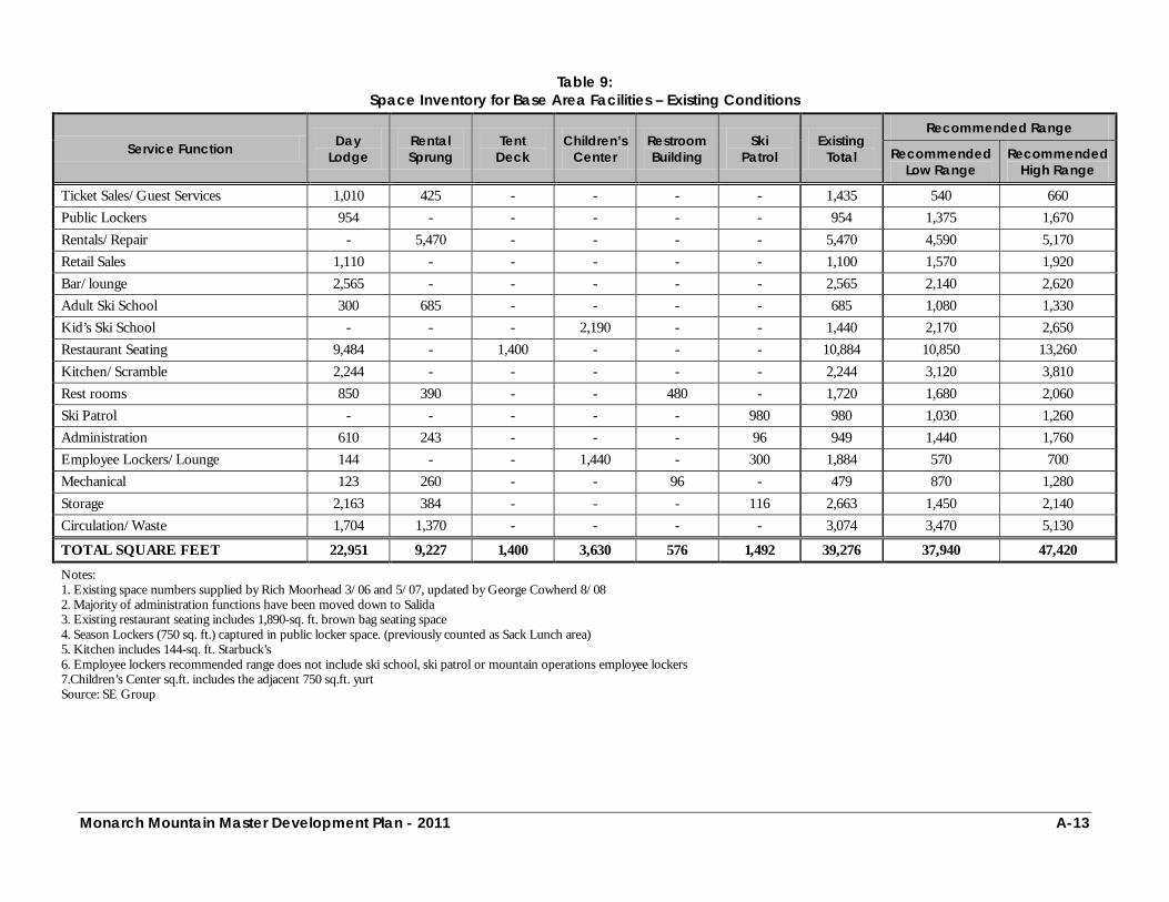
Monarch Mountain Master Development Plan - 2011 A-13
Table 9:
Space Inventory for Base Area Facilities – Existing Conditions
Service Function Day Lodge
Rental Sprung
Tent Deck
Children’s Center
Restroom Building
Ski Patrol
Existing Total
Recommended Range
Recommended Low Range
Recommended High Range
Ticket Sales/Guest Services 1,010 425 - - - - 1,435 540 660 Public Lockers 954 - - - - - 954 1,375 1,670 Rentals/Repair - 5,470 - - - - 5,470 4,590 5,170 Retail Sales 1,110 - - - - - 1,100 1,570 1,920 Bar/lounge 2,565 - - - - - 2,565 2,140 2,620 Adult Ski School 300 685 - - - - 685 1,080 1,330 Kid’s Ski School - - - 2,190 - - 1,440 2,170 2,650 Restaurant Seating 9,484 - 1,400 - - - 10,884 10,850 13,260 Kitchen/Scramble 2,244 - - - - - 2,244 3,120 3,810 Rest rooms 850 390 - - 480 - 1,720 1,680 2,060 Ski Patrol - - - - - 980 980 1,030 1,260 Administration 610 243 - - - 96 949 1,440 1,760 Employee Lockers/Lounge 144 - - 1,440 - 300 1,884 570 700 Mechanical 123 260 - - 96 - 479 870 1,280 Storage 2,163 384 - - - 116 2,663 1,450 2,140 Circulation/Waste 1,704 1,370 - - - - 3,074 3,470 5,130
TOTAL SQUARE FEET 22,951 9,227 1,400 3,630 576 1,492 39,276 37,940 47,420
Notes: 1. Existing space numbers supplied by Rich Moorhead 3/06 and 5/07, updated by George Cowherd 8/08 2. Majority of administration functions have been moved down to Salida 3. Existing restaurant seating includes 1,890-sq. ft. brown bag seating space 4. Season Lockers (750 sq. ft.) captured in public locker space. (previously counted as Sack Lunch area) 5. Kitchen includes 144-sq. ft. Starbuck’s 6. Employee lockers recommended range does not include ski school, ski patrol or mountain operations employee lockers 7.Children’s Center sq.ft. includes the adjacent 750 sq.ft. yurt Source: SE Group
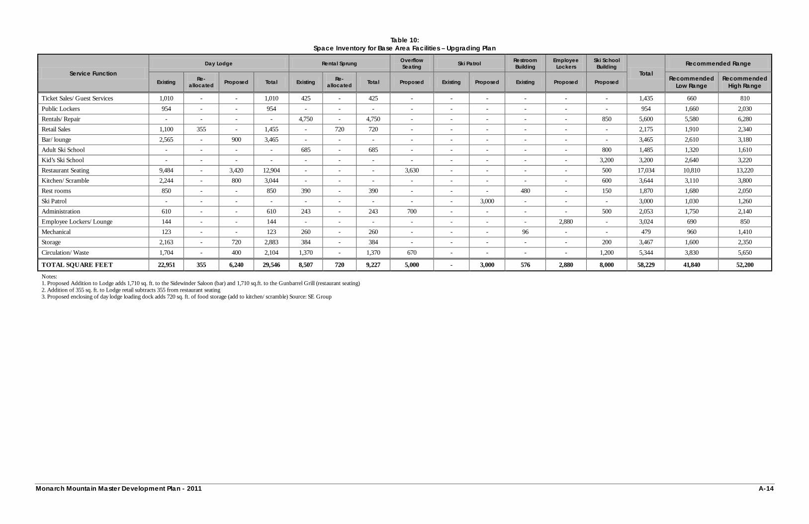
Monarch Mountain Master Development Plan - 2011 A-14
Table 10: Space Inventory for Base Area Facilities – Upgrading Plan
Service Function Day Lodge Rental Sprung Overflow
Seating Ski Patrol Restroom Building
Employee Lockers
Ski School Building
Total Recommended Range
Existing Re-allocated Proposed Total Existing Re-
allocated Total Proposed Existing Proposed Existing Proposed Proposed Recommended Low Range
Recommended High Range
Ticket Sales/Guest Services 1,010 - - 1,010 425 - 425 - - - - - - 1,435 660 810
Public Lockers 954 - - 954 - - - - - - - - - 954 1,660 2,030 Rentals/Repair - - - - 4,750 - 4,750 - - - - - 850 5,600 5,580 6,280 Retail Sales 1,100 355 - 1,455 - 720 720 - - - - - - 2,175 1,910 2,340 Bar/lounge 2,565 - 900 3,465 - - - - - - - - - 3,465 2,610 3,180 Adult Ski School - - - - 685 - 685 - - - - - 800 1,485 1,320 1,610 Kid’s Ski School - - - - - - - - - - - - 3,200 3,200 2,640 3,220 Restaurant Seating 9,484 - 3,420 12,904 - - - 3,630 - - - - 500 17,034 10,810 13,220 Kitchen/Scramble 2,244 - 800 3,044 - - - - - - - - 600 3,644 3,110 3,800 Rest rooms 850 - - 850 390 - 390 - - - 480 - 150 1,870 1,680 2,050 Ski Patrol - - - - - - - - - 3,000 - - - 3,000 1,030 1,260 Administration 610 - - 610 243 - 243 700 - - - - 500 2,053 1,750 2,140 Employee Lockers/Lounge 144 - - 144 - - - - - - - 2,880 - 3,024 690 850 Mechanical 123 - - 123 260 - 260 - - - 96 - - 479 960 1,410 Storage 2,163 - 720 2,883 384 - 384 - - - - - 200 3,467 1,600 2,350
Circulation/Waste 1,704 - 400 2,104 1,370 - 1,370 670 - - - - 1,200 5,344 3,830 5,650
TOTAL SQUARE FEET 22,951 355 6,240 29,546 8,507 720 9,227 5,000 - 3,000 576 2,880 8,000 58,229 41,840 52,200
Notes: 1. Proposed Addition to Lodge adds 1,710 sq. ft. to the Sidewinder Saloon (bar) and 1,710 sq.ft. to the Gunbarrel Grill (restaurant seating) 2. Addition of 355 sq. ft. to Lodge retail subtracts 355 from restaurant seating 3. Proposed enclosing of day lodge loading dock adds 720 sq. ft. of food storage (add to kitchen/scramble) Source: SE Group
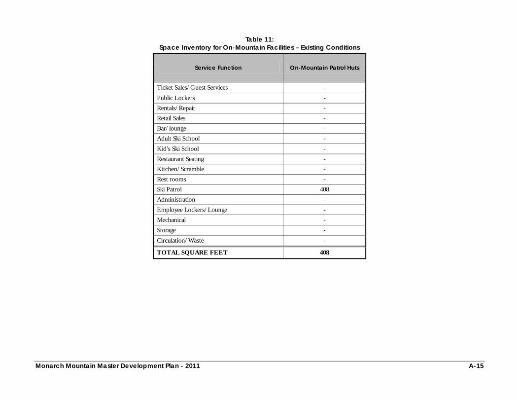
Monarch Mountain Master Development Plan - 2011 A-15
Table 11: Space Inventory for On-Mountain Facilities – Existing Conditions
Service Function On-Mountain Patrol Huts
Ticket Sales/Guest Services -
Public Lockers - Rentals/Repair - Retail Sales - Bar/lounge - Adult Ski School - Kid’s Ski School - Restaurant Seating - Kitchen/Scramble - Rest rooms - Ski Patrol 408 Administration - Employee Lockers/Lounge - Mechanical - Storage -
Circulation/Waste -
TOTAL SQUARE FEET 408
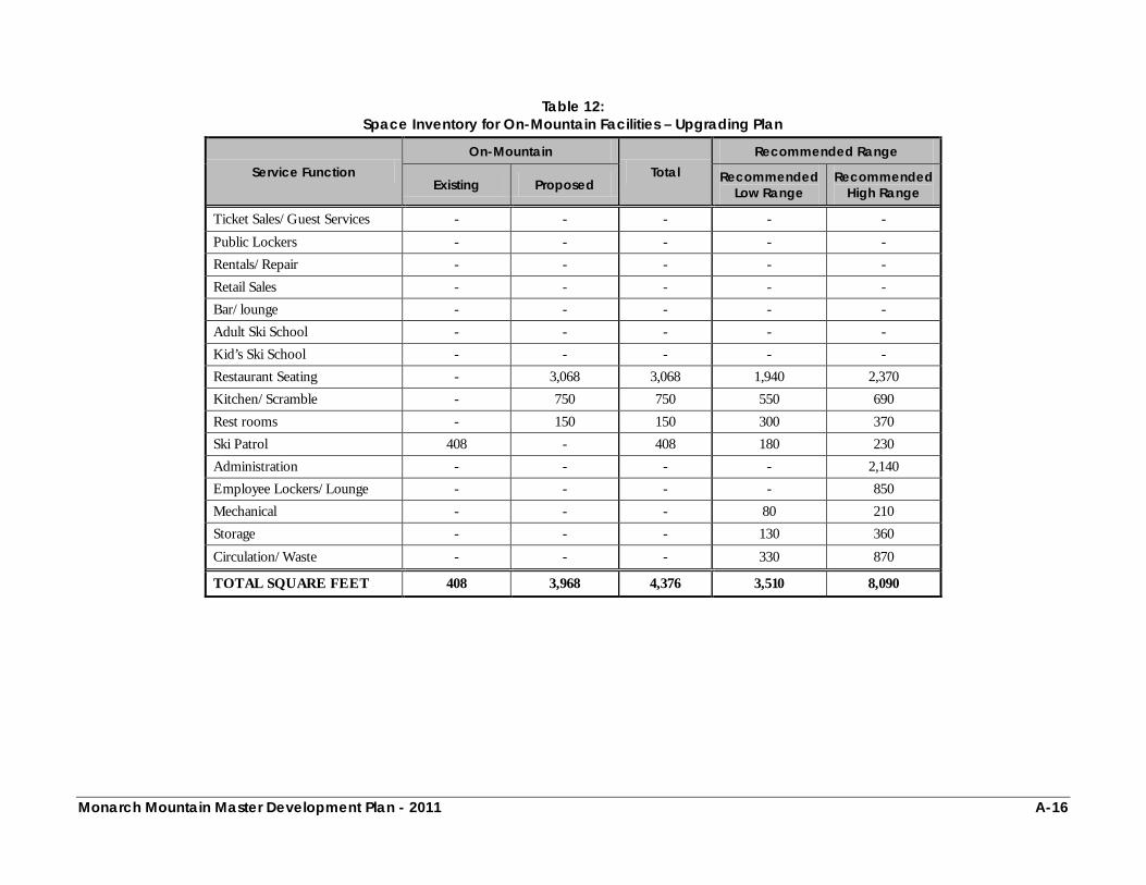
Monarch Mountain Master Development Plan - 2011 A-16
Table 12:
Space Inventory for On-Mountain Facilities – Upgrading Plan
Service Function On-Mountain
Total Recommended Range
Existing Proposed Recommended Low Range
Recommended High Range
Ticket Sales/Guest Services - - - - -
Public Lockers - - - - - Rentals/Repair - - - - - Retail Sales - - - - - Bar/lounge - - - - - Adult Ski School - - - - - Kid’s Ski School - - - - - Restaurant Seating - 3,068 3,068 1,940 2,370 Kitchen/Scramble - 750 750 550 690 Rest rooms - 150 150 300 370 Ski Patrol 408 - 408 180 230 Administration - - - - 2,140 Employee Lockers/Lounge - - - - 850 Mechanical - - - 80 210 Storage - - - 130 360
Circulation/Waste - - - 330 870
TOTAL SQUARE FEET 408 3,968 4,376 3,510 8,090
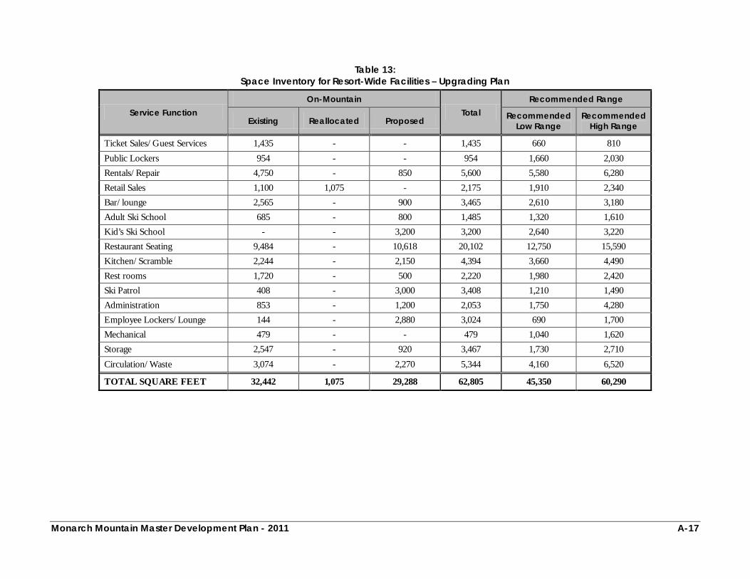
Monarch Mountain Master Development Plan - 2011 A-17
Table 13:
Space Inventory for Resort-Wide Facilities – Upgrading Plan
Service Function On-Mountain
Total Recommended Range
Existing Reallocated Proposed Recommended Low Range
Recommended High Range
Ticket Sales/Guest Services 1,435 - - 1,435 660 810
Public Lockers 954 - - 954 1,660 2,030 Rentals/Repair 4,750 - 850 5,600 5,580 6,280 Retail Sales 1,100 1,075 - 2,175 1,910 2,340 Bar/lounge 2,565 - 900 3,465 2,610 3,180 Adult Ski School 685 - 800 1,485 1,320 1,610 Kid’s Ski School - - 3,200 3,200 2,640 3,220 Restaurant Seating 9,484 - 10,618 20,102 12,750 15,590 Kitchen/Scramble 2,244 - 2,150 4,394 3,660 4,490 Rest rooms 1,720 - 500 2,220 1,980 2,420 Ski Patrol 408 - 3,000 3,408 1,210 1,490 Administration 853 - 1,200 2,053 1,750 4,280 Employee Lockers/Lounge 144 - 2,880 3,024 690 1,700 Mechanical 479 - - 479 1,040 1,620 Storage 2,547 - 920 3,467 1,730 2,710
Circulation/Waste 3,074 - 2,270 5,344 4,160 6,520
TOTAL SQUARE FEET 32,442 1,075 29,288 62,805 45,350 60,290
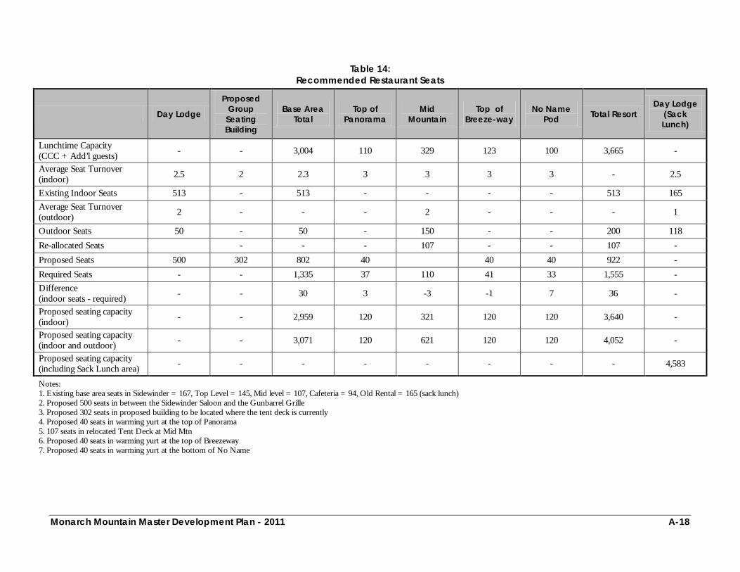
Monarch Mountain Master Development Plan - 2011 A-18
Table 14:
Recommended Restaurant Seats
Day Lodge
Proposed Group
Seating Building
Base Area Total
Top of Panorama
Mid Mountain
Top of Breeze-way
No Name Pod Total Resort
Day Lodge (Sack Lunch)
Lunchtime Capacity (CCC + Add’l guests) - - 3,004 110 329 123 100 3,665 -
Average Seat Turnover (indoor) 2.5 2 2.3 3 3 3 3 - 2.5
Existing Indoor Seats 513 - 513 - - - - 513 165 Average Seat Turnover (outdoor) 2 - - - 2 - - - 1
Outdoor Seats 50 - 50 - 150 - - 200 118 Re-allocated Seats - - - 107 - - 107 - Proposed Seats 500 302 802 40 40 40 922 - Required Seats - - 1,335 37 110 41 33 1,555 - Difference (indoor seats - required) - - 30 3 -3 -1 7 36 -
Proposed seating capacity (indoor) - - 2,959 120 321 120 120 3,640 -
Proposed seating capacity (indoor and outdoor) - - 3,071 120 621 120 120 4,052 -
Proposed seating capacity (including Sack Lunch area) - - - - - - - - 4,583
Notes: 1. Existing base area seats in Sidewinder = 167, Top Level = 145, Mid level = 107, Cafeteria = 94, Old Rental = 165 (sack lunch) 2. Proposed 500 seats in between the Sidewinder Saloon and the Gunbarrel Grille 3. Proposed 302 seats in proposed building to be located where the tent deck is currently 4. Proposed 40 seats in warming yurt at the top of Panorama 5. 107 seats in relocated Tent Deck at Mid Mtn 6. Proposed 40 seats in warming yurt at the top of Breezeway 7. Proposed 40 seats in warming yurt at the bottom of No Name