Embed Size (px)
Citation preview

1
CAIRT Newsletter of the Scottish Maps Forum
Issue 22 January 2013
In this issue:
• Bartholomew Archive exhibition and news
• New Map Images website
• Recent digitisation
• Survey Atlas facsimile
• Ordnance Survey map series cataloguing
• Westmorland man
• Recent acquisition – Minchiate maps
_____________________
SCOTTISH MAPS FORUM
The Forum was initiated by the National Library of Scotland in 2002: � To encourage multi-disciplinary map use, study and research, particularly relating to Scottish maps and mapmakers �To disseminate information on Scottish maps and map collections �To record information on maps and mapmaking, particularly in a Scottish context �To liaise with other groups and individuals with map related interests �To build on, and to continue, the work of Project Pont
CAIRT
The newsletter is issued twice a year. "Cairt" is Gaelic & 17th century Scots for map. For further information, or to be added to the mailing list, please contact:
Scottish Maps Forum
National Library of Scotland 159 Causewayside
Edinburgh EH9 1PH
Tel: 0131 623 3970 Fax: 0131 623 3971
E-mail: [email protected]
ISSN 1477-4186 © 2013 NLS Editor: C. Fleet Technical Ed: J. Parkerson
Bartholomew Archive Exhibition
After almost a year of preparation, we are happy to bring you the news that our winter/spring exhibition, Putting Scotland on the Map: The World of John Bartholomew and Son opened in December. This free exhibition is housed in our main George IV Bridge building and will run until the 7th May 2013.
Using material from the Bartholomew Archive, this exhibition brings Bartholomew’s Duncan Street premises back to life, as we explore how Bartholomew produced their world-renowned maps.
The exhibition follows the life of a map from the compilation of source material, to hand-made engraving tools, to the bustle of the printing room floor. Visitors will have the chance to meet one of Bartholomew’s most influential characters, John George Bartholomew; to enter the upside down and back to front world of the copperplate engravers and to view some of the treasures of the John Bartholomew collection of rare and antiquarian atlases, including the second ever printed map of North America, Forlani’s Il disegno del discoperto della noua Franza (1566).
This is the first major exhibition at NLS on a cartographic theme since Scotland’s First Atlas: The Nation Displayed by Joan Blaeu, in 2004. We hope that it will be a fitting celebration of this influential firm and we hope to see you there. (cont. overleaf)
2
In addition to the exhibition, there are a series of Bartholomew-related events scheduled for the New Year. John Eric Bartholomew, the eldest son of John Christopher Bartholomew, will deliver a richly illustrated talk about the family and firm from his uniquely personal perspective. It promises to be a very illuminating and entertaining event, held in our George IV Bridge building on 31 January at 18.00. This is a free event, but as it is ticketed and likely to be extremely popular, early booking is recommended; see below for details. We are also extremely excited to announce the appointment of two artists-in-residence, one textile artist and one writer, who will be working with the Bartholomew Archive and our map collections in general, between February and May 2013. Diane Garrick is a Shetland-based textile artist who has exhibited widely at venues across Shetland. Diane is particularly interested in exploring sensory maps and the cultural impact that cartography has had on Scottish society. Tom Pow is an extremely experienced and highly respected writer and broadcaster who has an infectious enthusiasm for the subject.
Both Diane and Tom have drawn on maps as a source of inspiration for previous work. We are looking forward to exploring our collections through Diane and Tom’s eyes. There will be a series of public events related to this joint residency, with details to follow. 2012 has been a very exciting year for the Bartholomew Archive Project, with the exhibition as arguably the crowning glory. We hope that as a result, we can make 2013 our best year ever, not least because this will be the final year of the Project.
Karla Baker Bartholomew Archive Curator
Bartholomew Archive (contd.) – events and artists-in-residence
Further exhibition information http://www.nls.uk/exhibitions/bartholomew Event bookings can be made at http://www.nls.uk/events/booking or by calling 0131 623 3734
New NLS Map Images website
In November we revised our maps website homepage and structure to try to improve search and navigation. One of the main aims behind this is to promote geographic, map-based access to all 48,000 online maps through our Find by Place application. The related and traditional search method by browsable textual lists is now called Browse by category. These two main search methods are available as quick button links on all pages, integrating the georeferenced search applications with the main map content. It is also possible to search by mapmakers / surveyors / engravers and by keyword. We have also tried to improve navigation by giving all pages a consistent header, footer and breadcrumb trail, showing the position of the page in the overall structure.
For those who link to our website, the good news is that we have kept all URLs to maps the same - everything at http://maps.nls.uk... is the same as before. However, the georeferenced search applications formerly under http://geo.nls.uk have been moved under the http://maps.nls.uk/ domain. In addition, the site is now completely dedicated to viewing maps, deliberately separate from the main NLS website. An "Order this map" button in the header allows photocopies, printouts and images to be ordered of anything on the website. We have also renamed the Maps of Scotland website as Map Images, to reflect the initial content beyond Scotland which we expect to grow in future. Finally, the zoomable image viewers have been updated to now make them fully smartphone / mobile compatible. We would be very happy to receive feedback or suggestions relating to the Map Images website as we continue to develop and add content to it.

3
New website addition - Bartholomew half-inch maps of Great Britain (1897-1909)
In connection with the NLS Bartholomew exhibition we added a set of Bartholomew half-inch to the mile mapping for Great Britain (1897-1909) to our website. This includes 29 sheets covering Scotland and 37 sheets covering England and Wales:
http://maps.nls.uk/series/bart_half_scotland.html and http://maps.nls.uk/series/bart_half_england.html
You can also explore Bartholomew half-inch maps through two related applications on our Bartholomew Archive website:
1. Great Britain time traveller ( http://geo.nls.uk/maps/bartholomew/ great_britain/index.html ) allows Bartholomew half-inch maps from a century ago to be compared to modern maps, including a modern Collins Geo Touring map. 2. Cairngorms layer colour explorer ( http://geo.nls.uk/maps/bartholomew/ layers/index.html ) allows six Bartholomew half-inch maps (1890-1905), with their different palettes for contour layer colouring to be compared to each other and to modern Google terrain and other layers. (see image, right)
Recent digitisation projects
These two book digitisation projects have been scanned with the Internet Archive and are currently available on their website. They will be integrated into the NLS website during 2013.
From August, ScotlandsPlaces ( http://www.scotlandsplaces.gov.uk ) started adding digitised versions of the Ordnance Survey Name Books for Scotland as a subscription-based resource. The Name Books contain uniquely valuable information on the form of names used on the OS first edition mapping, including the alternative name forms, authorities consulted, and descriptive remarks. The Name Book entries have been indexed and link through to the relevant OS 25 inch mapping showing the name. The plan is to make all counties available by the autumn of 2013.
• Ordnance Survey Books of Reference for Scotland, 1850s-1880s 22 volumes of OS Books of Reference, including acreages and land use information for all land parcels shown on the first edition 25 inch maps (see image, right):
http://archive.org/details/osbooksofreference
• Descriptive Gazetteers of Scotland (19th century) A collection of 20 volumes of descriptive gazetteers of Scotland, dating between 1803 and 1901 by Chambers, Wilson, Fullarton and Groome, etc. Also includes John Wood's Descriptive account of the principal towns in Scotland (1828): http://archive.org/details/scottishgazetteers
4
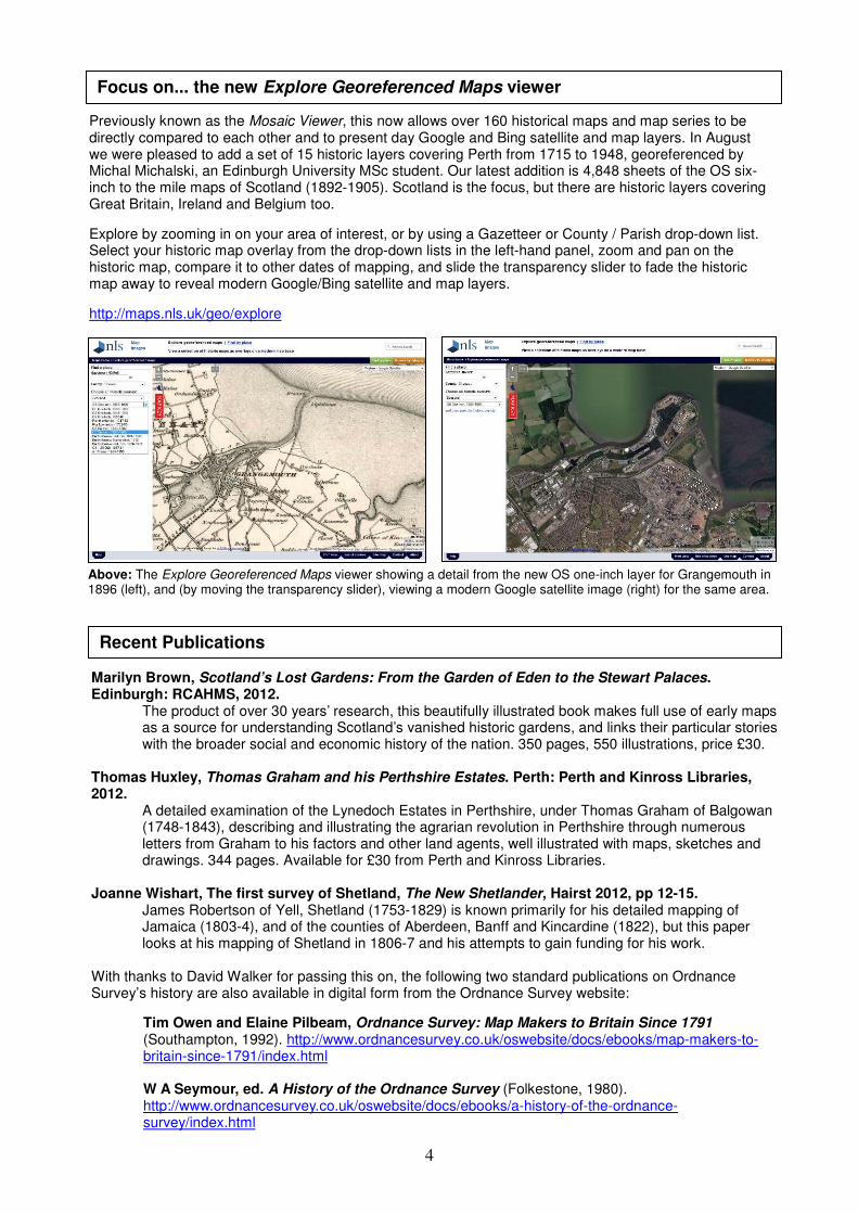
Previously known as the Mosaic Viewer, this now allows over 160 historical maps and map series to be directly compared to each other and to present day Google and Bing satellite and map layers. In August we were pleased to add a set of 15 historic layers covering Perth from 1715 to 1948, georeferenced by Michal Michalski, an Edinburgh University MSc student. Our latest addition is 4,848 sheets of the OS six-inch to the mile maps of Scotland (1892-1905). Scotland is the focus, but there are historic layers covering Great Britain, Ireland and Belgium too.
Explore by zooming in on your area of interest, or by using a Gazetteer or County / Parish drop-down list. Select your historic map overlay from the drop-down lists in the left-hand panel, zoom and pan on the historic map, compare it to other dates of mapping, and slide the transparency slider to fade the historic map away to reveal modern Google/Bing satellite and map layers.
http://maps.nls.uk/geo/explore
Focus on... the new Explore Georeferenced Maps viewer
Above: The Explore Georeferenced Maps viewer showing a detail from the new OS one-inch layer for Grangemouth in 1896 (left), and (by moving the transparency slider), viewing a modern Google satellite image (right) for the same area.
Recent Publications
Marilyn Brown, Scotland’s Lost Gardens: From the Garden of Eden to the Stewart Palaces. Edinburgh: RCAHMS, 2012. The product of over 30 years’ research, this beautifully illustrated book makes full use of early maps
as a source for understanding Scotland’s vanished historic gardens, and links their particular stories with the broader social and economic history of the nation. 350 pages, 550 illustrations, price £30.
Thomas Huxley, Thomas Graham and his Perthshire Estates. Perth: Perth and Kinross Libraries, 2012.
A detailed examination of the Lynedoch Estates in Perthshire, under Thomas Graham of Balgowan (1748-1843), describing and illustrating the agrarian revolution in Perthshire through numerous letters from Graham to his factors and other land agents, well illustrated with maps, sketches and drawings. 344 pages. Available for £30 from Perth and Kinross Libraries.
Joanne Wishart, The first survey of Shetland, The New Shetlander, Hairst 2012, pp 12-15.
James Robertson of Yell, Shetland (1753-1829) is known primarily for his detailed mapping of Jamaica (1803-4), and of the counties of Aberdeen, Banff and Kincardine (1822), but this paper looks at his mapping of Shetland in 1806-7 and his attempts to gain funding for his work.
With thanks to David Walker for passing this on, the following two standard publications on Ordnance Survey’s history are also available in digital form from the Ordnance Survey website:
Tim Owen and Elaine Pilbeam, Ordnance Survey: Map Makers to Britain Since 1791 (Southampton, 1992). http://www.ordnancesurvey.co.uk/oswebsite/docs/ebooks/map-makers-to-britain-since-1791/index.html
W A Seymour, ed. A History of the Ordnance Survey (Folkestone, 1980). http://www.ordnancesurvey.co.uk/oswebsite/docs/ebooks/a-history-of-the-ordnance-survey/index.html
5
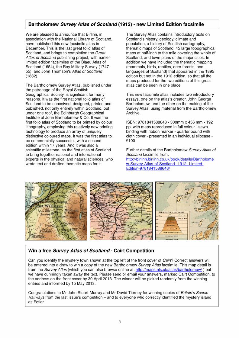
Bartholomew Survey Atlas of Scotland (1912) - new Limited Edition facsimile
We are pleased to announce that Birlinn, in association with the National Library of Scotland, have published this new facsimile atlas in December. This is the last great folio atlas of Scotland, and brings to completion the Great Atlas of Scotland publishing project, with earlier limited edition facsimiles of the Blaeu Atlas of Scotland (1654), the Roy Military Survey (1747-55), and John Thomson's Atlas of Scotland (1832). The Bartholomew Survey Atlas, published under the patronage of the Royal Scottish Geographical Society, is significant for many reasons. It was the first national folio atlas of Scotland to be conceived, designed, printed and published, not only entirely within Scotland, but under one roof, the Edinburgh Geographical Institute of John Bartholomew & Co. It was the first folio atlas of Scotland to be printed by colour lithography, employing this relatively new printing technology to produce an array of uniquely distinctive coloured maps. It was the first atlas to be commercially successful, with a second edition within 17 years. And it was also a scientific milestone, as the first atlas of Scotland to bring together national and international experts in the physical and natural sciences, who wrote text and drafted thematic maps for it.
The Survey Atlas contains introductory texts on Scotland's history, geology, climate and population, a history of Scottish cartography, thematic maps of Scotland, 45 large topographical maps at half-inch to the mile covering the whole of Scotland, and town plans of the major cities. In addition we have included the thematic mapping (mammals, birds, reptiles, deer forests, and languages of Scotland) that appeared in the 1895 edition but not in the 1912 edition, so that all the maps produced for the two editions of this great atlas can be seen in one place. This new facsimile atlas includes two introductory essays, one on the atlas's creator, John George Bartholomew, and the other on the making of the Survey Atlas, using material from the Bartholomew Archive. ISBN: 9781841588643 - 300mm x 456 mm - 192 pp. with maps reproduced in full colour - sewn binding with ribbon marker - quarter bound with cloth cover - presented in an individual slipcase - £100 Further details of the Bartholomew Survey Atlas of Scotland facsimile from: http://birlinn.birlinn.co.uk/book/details/Bartholomew-Survey-Atlas-of-Scotland--1912--Limited-Edition-9781841588643/
Win a free Survey Atlas of Scotland - Cairt Competition Can you identify the mystery town shown at the top left of the front cover of Cairt? Correct answers will be entered into a draw to win a copy of the new Bartholomew Survey Atlas facsimile. This map detail is from the Survey Atlas (which you can also browse online at: http://maps.nls.uk/atlas/bartholomew/ ) but we have cunningly taken away the text. Please send or email your answers, marked Cairt Competition, to the address on the front cover by 30 April 2013. The winner will be picked randomly from the winning entries and informed by 15 May 2013. Congratulations to Mr John Stuart-Murray and Mr David Tierney for winning copies of Britain's Scenic Railways from the last issue’s competition – and to everyone who correctly identified the mystery island as Fetlar.

6
Ordnance Survey map ‘series’ cataloguing project
Over the last few months, staff at National Library of Scotland, Map Collections have completed a project to identify and catalogue the Library’s holdings of Ordnance Survey maps. The OS catalogue entries that can be accessed through the NLS website http://www.nls.uk/catalogues reflect our interpretation of the OS series, and are not an attempt to reflect all the distinctions and relationships that such a complex map collection could be divided into.
The OS did not always describe map series with an ‘official’ series title, and so map users and researchers have sometimes had to invent their own titles. We have been guided by the titles that were sometimes printed on OS maps, and also by the ‘traditional’ names given to OS maps in debates and written articles. A glance at the following partial lists illustrates our interpretation and description of some of the OS series.
Such lists are necessarily subjective, but the NLS series titles are intended to place the OS maps held at NLS within the broader collections in a consistent way. For example, it was decided to retain OS printed titles (‘Popular’), but if no title was offered by the OS, then a ‘traditional’ title was employed (‘Coloured Parishes’).
National Library of Scotland Title for OS series date range (holdings across all series)
Scotland England & Wales
Northern Ireland
Great Britain
Ireland
Town Plan
1:500. 1841-1910 -(NI 2008) D p
p
1:1056. 1841-1895 -(NI 2008) D p
County Parish edition 1:2500. 1855-1882 D
p
Parish Combined Reprints 1:2500. 1855-1882 D
2nd & later editions 1:2500. 1892-1949 D
1st edition 1:10,560. 1823-1882 D p
p
p
2nd & later editions 1:10,560. 1892-1960 D p p
One-inch
1st edition. 1829-1891 -(Ire.1920) D p p
Coloured Parishes. 1898-1904 D
2nd edition. 1842-1900 D p p
3rd edition. 1901-1912 -(NI 1979) D p p
Popular. 1909-1945 -(NI 1958) D p p
Popular with National Grid. 1945-1955 D
5th edition. 1928-1937 p
New Popular edition. 1945-1947 p
7th edition. 1952-1961 D
The OS surveys of the British Isles were usually distinct for each of the nations, before the Second World War, and the NLS series titles reflect the reality of these national distinctions by defining series by ‘national survey’, ‘series’ & ‘edition’. So the series title that is entered into the NLS Main Catalogue for the Parish edition covering Scotland, would be; Ordnance Survey Scotland County Series : Parish edition 1:2500, and for the OS One-inch to the mile maps of Great Britain, Seventh Series, 1952-1961, the title would be; Ordnance Survey Great Britain One-inch Series : 7th edition.
The OS catalogue project also involved attaching web-links from the NLS Main Catalogue entries to the OS maps that are available on-line as digital-copy formats and are a part of the NLS Digital Collection http://maps.nls.uk. This enables a researcher who is not using, or is not aware, of the NLS Map Images website, to directly access the OS historic map digital copies directly from the NLS catalogue. The table below illustrates that NLS has concentrated on providing digital web-access to OS maps that are specifically related to Scotland and are out of copyright, but future projects should increase the number of OS map series that are digitally copied and available through the NLS Map Images website and the NLS catalogue.
On the lists of titles in this table ‘D’ indicates a catalogue entry with a web-link to NLS digital copies, & ‘p’ is an
NLS catalogue entry for the original paper copies. Robert Harold
NLS Ordnance Survey Catalogue Project
7
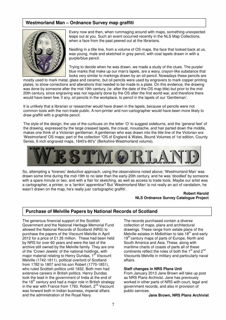
Westmorland Man – Ordnance Survey map graffiti
Every now and then, when rummaging around with maps, something unexpected leaps out at you. Such an event occurred recently in the NLS Map Collections, when a face from the past peered out at the librarians.
Nestling in a title line, from a volume of OS maps, the face that looked back at us, was young, male and sketched in grey pencil, with coat lapels drawn in with a purple/blue pencil.
Trying to decide when he was drawn, we made a study of the clues. The purple/ blue marks that make up our man’s lapels, are a waxy, crayon-like substance that looks very similar to markings drawn by an oil-pencil. Nowadays these pencils are
mostly used to mark metal, glass and ceramic, but oil pencils were used by engravers to mark copper printing plates, to show corrections and alterations that needed to be made to a plate. On this evidence, the drawing was done by someone after the mid 19th century, (ie: after the date of the OS map title) but prior to the mid 20th century, since engraving was not regularly done by the OS after the first world war, and therefore there would have been few, if any, oil pencils in the workplace, to pencil in the lapels of our ‘Gentleman’. It is unlikely that a librarian or researcher would have drawn in the lapels, because oil pencils were not common tools with the non-trade public. A non-printer and non-cartographer would have been more likely to draw graffiti with a graphite pencil. The style of the design, the use of the curlicues on the letter ‘O’ to suggest sideburns, and the ‘general feel’ of the drawing, expressed by the large creased lapels, the cravat, moustache, and hair parted down the middle, makes one think of a Victorian gentleman. A gentleman who was drawn into the title line of the Victorian era ‘Westmorland’ OS maps; part of the collection “OS of England & Wales, Bound Volumes of 1st edition, County Series, 6 inch engraved maps, 1840's-80's” (Berkshire-Westmorland volume).
So, attempting a ‘forensic’ deductive approach, using the observations noted above; ‘Westmorland Man’ was drawn some time during the mid-19th to no later than the early-20th century, and he was ‘doodled’ by someone with a spare minute or two, and with a flair for sketching, as well as access to trade tools. Maybe our artist was a cartographer, a printer, or a ‘larrikin’ apprentice? But ‘Westmorland Man’ is not really an act of vandalism, he wasn’t drawn on the map, he’s really just ‘cartographic graffiti’.
Robert Harold NLS Ordnance Survey Catalogue Project
The generous financial support of the Scottish Government and the National Heritage Memorial Fund allowed the National Records of Scotland (NRS) to purchase the papers of the Viscount Melville in April 2012 for a price of £1.35 million. These had been held by NRS for over 60 years and were the last of the archive still owned by the Melville family. They are one of the ‘Crown Jewels’ of the national holdings, with major material relating to Henry Dundas, 1
st Viscount
Melville (1742-1811), political overlord of Scotland from 1782 to 1807 and his son Robert (1770-1851), who ruled Scottish politics until 1832. Both men had extensive careers in British politics. Henry Dundas took the lead in the government of India at the end of the 18
th century and had a major role in British strategy
in the war with France from 1793. Robert, 2nd
Viscount was forward both in Indian business, imperial affairs and the administration of the Royal Navy.
Purchase of Melville Papers by National Records of Scotland
The records purchased contain a diverse collection of maps, plans and architectural drawings. These range from estate plans of the Melville estates in Midlothian to late 18
th and early
19th
century maps of parts of Europe, North and South America and Asia. These, along with maritime charts of coasts of parts all of these continents reflect the roles of both the 1
st and 2
nd
Viscounts Melville in military and particularly naval affairs. Staff changes in NRS Plans Unit From January 2013 Jane Brown will take up post as NRS Plans Archivist. Jane has previously worked in other parts of NRS with court, legal and government records, and also in provision of public services.
Jane Brown, NRS Plans Archivist

8
NLS Recent Acquisitions - Minchiate maps
Two recent, small arrivals in the Maps Collection at the NLS are examples from an unusual and rare set of playing cards. Scozia settentrionale anticamente Codanonia and Scozia meridionale anticamente Codanonia depict maps of north and south Scotland and were published by Augusto da Rabatta and Jean Baptiste Baillou in Florence in 1779 for a Minchiate deck.
The Minchiate game originated in medieval Florence, and its deck of 92 cards includes an expanded major arcana, or set of trumps. A game of collecting tricks, its popularity spread through most of Europe before dying out in the early twentieth century. The deck’s significance today is in helping scholars establish the original meanings or significance of the symbols and pictures in its sister deck the Tarrochi, or tarot, which has similar although fewer cards in its major arcana. Both games focus around the unnumbered Fool card. Indeed “minchiate” is a dialect word meaning “nonsense”. The two cards are the 7 and 8 of cups from the minor arcana. Each of the number or pip cards in this set were printed with a small map from all across the known world, a key to the main towns and features of that country, as well as their suit symbol of cups, coins, swords or batons. The key takes up more than half the card; it’s hard not to think that they could just have used the space for bigger maps and then not needed the key at all! They were engraved by Aniello Lamberti and included with all the maps in a pocket atlas Nuovo Atlante Generale Metodico, ed Elementare Tascabile.
Paula Williams, Senior Map Curator
Old Maps Online
This project and website continues to grow and is now the world’s largest portal to discovering online images of historical maps. The website provides free access to over 140,000 maps, including nearly 50,000 maps of Scotland. http://www.oldmapsonline.org
We are very pleased to announce that the Royal Society of Edinburgh have funded a research workshop and follow-on knowledge exchange event on the theme of Mapping the Nation: representations of Scotland, 1200-1700. The project is led by Dr Anna Groundwater of Edinburgh University, with Chris Fleet of the National Library of Scotland. The research workshop will be held in the summer of 2013 at the NLS. A second larger conference engaging with representatives from secondary education is planned for January 2014. We will be sending out further details in March 2013, and for further information, please see http://www.nls.uk/events from April 2013. We hope to hold the next Scottish Maps Forum seminar in the autumn and advertise it in the next issue of Cairt.
Forthcoming workshop: Mapping the Nation: representations of Scotland, 1200-1700