Embed Size (px)
Citation preview
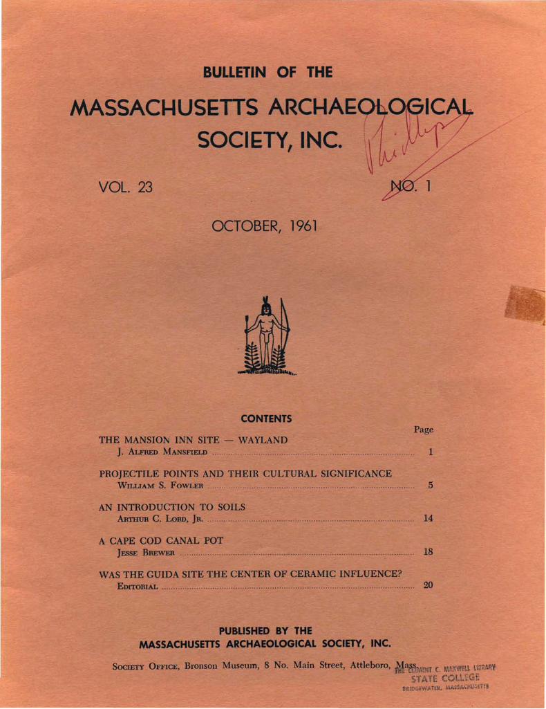
BUllETIN OF THE
MASSACI-IUSETTS ARCI-IAESOCIETY, I C.
VOL. 23
PageCONTENTS
1
OCTOBER, 1961
PROJECTILE POINTS AND THEIR CULTURAL SIGNIFICANCEWILLIAM S. FOWLER 5
PUBUSHED BY THEMASSACHUSETTS ARCHAEOLOGICAL SOCIETY, INC.
AN INTRODUCTION TO SOILSARTHUR C. :LoaD, Ja. 14
A CAPE COD CANAL POTJESSE BBEWER , 18
WAS THE GUIDA SITE THE CENTER OF CERAMIC INFLUENCE?Eorro1uAL ,. 20
Sc:x::mTY OFFICE, Bronson Museum, 8 No. Main Street, Attleboro, !NT c. weu. UllllARV
S1ATE COLI. ~IRIOGEW"TEa. MASS/O'HU:; Til
THE MANSION INN SITE - WAYLANDJ. A1.FRED MANSFIELD ..
MASSACHUSEITS ARCHAEOLOGICAL SOCIETY
OFFICERS
PresidentViggo C. Petersen 4 Cottage Street. Marion. Mass.
First Vice PresidentArthur C. Lord 38 Worcester Street. Bridgewater. Mass.
Second Vice PresidentHarold F. Nye Marion. Mass.
SecretaryMaurice Robbins Bronson Museum. Attleboro. Mass.
TreasurerArthur C. Staples Segreganset. Mass.
EditorWilliam S. Fowler Bronson Museum. Attleboro. Mass.
TftI8IeeB
Society Of6cers and Past Presidents. Ex OfficioWalter Thomas. Jr. William D. Brierly Laurence K. GahanGuy Mellgren. Jr. Donald C. Wilder Robert Valyou
MASSACHUSEITS ARCHAEOLOGICAL SOCIETY BULLETIN published in four Numbers of one Volume each year. commencing in October.
Price this issue: $ .75
(Subscription by membership in the Society: $3.(0)
Note: Address aU f'equem concerning membership to the Secretary; aU ordersfor back Bulletin numbers (4 for $1.00 to members) to the Editor; and maaSociety dues to the Treasurer.
BRONSON MUSEUM
This is the Society's museum. 5th Floor of the 8 North Main Street Building.Attleboro. Mass. - Museum hours are from 9:30 to 4:30. Mondays. Tuesdays.and Thursdays. For special arrangements to visit on other days. contact theDirector. Maurice Robbins. or the Curator. William S. Fowler by mail at theSociety Office. Bronson Museum. Attleboro. Mass.
The Museum includes exhibits of artifacts and seven dioramas portrayingman's prehistoric occupation of New England. The displays are arranged so asto show man's development through four culture stages. from early post glacialtimes.
The most recent diorama extends 15 feet across the front of the museum.It depicts an Archaic village of seven large and unique wigwams as indicatedby their foundations. excavated at Assowampsett Lake by the Cohannet Chapter.Human figures to scale make the scene come alive and help create whatunquestionably is an outstanding addition to our ever growing museum displays.
THE MANSION INN SITE - WAYLANO*
J. .A1.FREo MANSFIELD
1
This site is situated on a high Hat knoll, approximately 20 feet higher than the narrow ridge,which separates Dudley Pond from Lake Cochituatein Wayland, Massachusetts. It lies about 200 yardsequidistant from both bodies of water, and only ashort way from the Sudbury River. This affordedcontact by water travel with other parts of thecountry. In historic times, the main Indian trail,known to the English as the Old Connecticut Path,connecting the Boston area with Connecticut regions, ran close by the site. One day in 1959, whiledriving to see friends in Saxonville, I noticed thatthe place, where the old Mansion Inn had formerlystood - recently destroyed by fire - was bulldozed,and a steam shovel had commenced to excavate.Intrigued by the possibility of new discoveries, Idecided to return after the first good rain, especiallysince this site was one of the best I knew of, fromwhich many artifacts had been recovered, by surface hunting in past years.
The following week, on a Sunday afternoon, Ireturned with Leslie Longworth, also a member ofthe Massachusetts Archaeological Society. The soilwas very dry - no rain had fallen since my firstvisit - and no occupational evidence appeared onthe surface. However, we were attracted to onespot, where almost pure charcoal had been exposedby bulldozer operations. It covered an area about6 x 8 feet in size. Here, we noticed several brokenstone knife blades sticking out of the charcoal atvarious angles. Realizing that excavation was necessary, we procured trowels from our cars, laid outthe disturbed space in 3 foot squares, and began toexcavate the charcoal-filled area. We felt impelledto hasten as much as possible, for fear of impendingdestruction by building operations, in evidence onall sides.
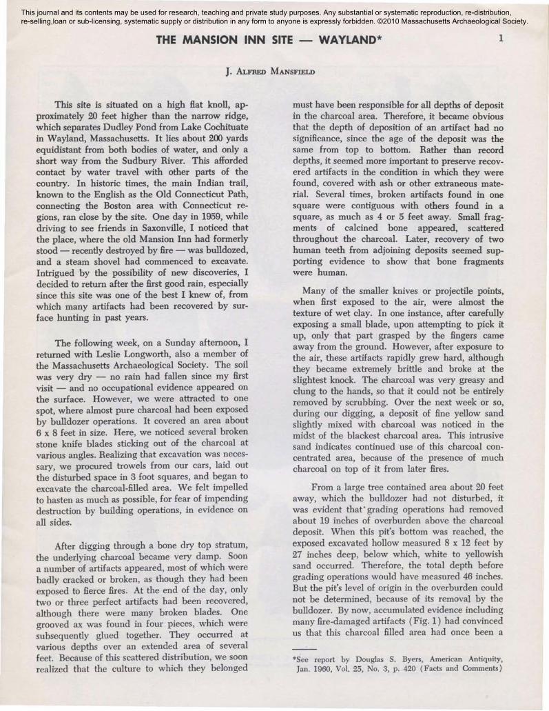
After digging through a bone dry top stratum,the underlying charcoal became very damp. Soona number of artifacts appeared, most of which werebadly cracked or broken, as though they had beenexposed to fierce fires. At the end of the day, onlytwo or three perfect artifacts had been recovered,although there were many broken blades. Onegrooved ax was found in four pieces, which weresubsequently glued together. They occurred atvarious depths over an extended area of severalfeet. Because of this scattered distribution, we soonrealized that the culture to which they belonged
must have been responsible for all depths of depositin the charcoal area. Therefore, it became obviousthat the depth of deposition of an artifact had nosignificance, since the age of the deposit was thesame from top to bottom. Rather than recorddepths, it seemed more important to preserve recovered artifacts in the condition in which they werefound, covered with ash or other extraneous material. Several times, broken artifacts found in onesquare were contiguous with others found in asquare, as much as 4 or 5 feet away. Small fragments of calcined bone appeared, scatteredthroughout the charcoal. Later, recovery of twohuman teeth from adjoining deposits seemed supporting evidence to show that bone fragmentswere human.
Many of the smaller knives or projectile points,when first exposed to the air, were almost thetexture of wet clay. In one instance, after carefullyexposing a small blade, upon attempting to pick itup, only that part grasped by the fingers cameaway from the ground. However, after exposure tothe air, these artifacts rapidly grew hard, althoughthey became extremely brittle and broke at theslightest knock. The charcoal was very greasy andclung to the hands, so that it could not be entirelyremoved by scrubbing. Over the next week or so,during our digging, a deposit of fine yellow sandslightly mixed with charcoal was noticed in themidst of the blackest charcoal area. This intrusivesand indicates continued use of this charcoal concentrated area, because of the presence of muchcharcoal on top of it from later fires.
From a large tree contained area about 20 feetaway, which the bulldozer had not disturbed, itwas evident that' grading operations had removedabout 19 inches of overburden above the charcoaldeposit. When this pit's bottom was reached, theexposed excavated hollow measured 8 x 12 feet by27 inches deep, below which, white to yellowishsand occurred. Therefore, the total depth beforegrading operations would have measured 46 inches.But the pit's level of origin in the overburden couldnot be determined, because of its removal by thebulldozer. By now, accumulated evidence includingmany fire-damaged artifacts (Fig. 1) had convincedus that this charcoal filled area had once been a
*See report by Douglas S. Byers, American Antiquity,Jan. 1960, Vol. 25, No.3, p. 420 (Facts and Comments)
This journal and its contents may be used for research, teaching and private study purposes. Any substantial or systematic reproduction, re-distribution, re-selling,loan or sub-licensing, systematic supply or distribution in any form to anyone is expressly forbidden. ©2010 Massachusetts Archaeological Society.
2 MASSACHUSETTS ARCHAEOLOGICAL SOCIETY
...... ...,"\.
I,IIIII,
I,.,,,,,,I,
II
I,/.#'
17 18
9
Fig. 1. CREMATORY GOODS - Mansion Inn Site. 1·3. Celh; 4. 5. Full Grooved Axes; 6. 7, Short Plain Gouges; 8. 9. Hatcheh; 10. Pestle;11. 12. Side.notched Points; 13, 14. Eared Points; 16. 17. Tapered Stem Poinh; 15. 5temle.. Knife; 18. Eared Drill. (1·10. 15. Scattered throughout;11.14. 16-18. in cache at bottom of crematory).
THE MANSION INN SITE - WAYLAND 3
crematory, where human bodies were burned before burial. If this were so, then, we reasoned,there should be secondary burial deposits nearby.Impressed by the importance of the find, we werecareful to fill in the excavated area at the end ofeach day, especially since several homes were infull view, and the roadway was only about 40 feetaway, although fortunately above and out of sight.
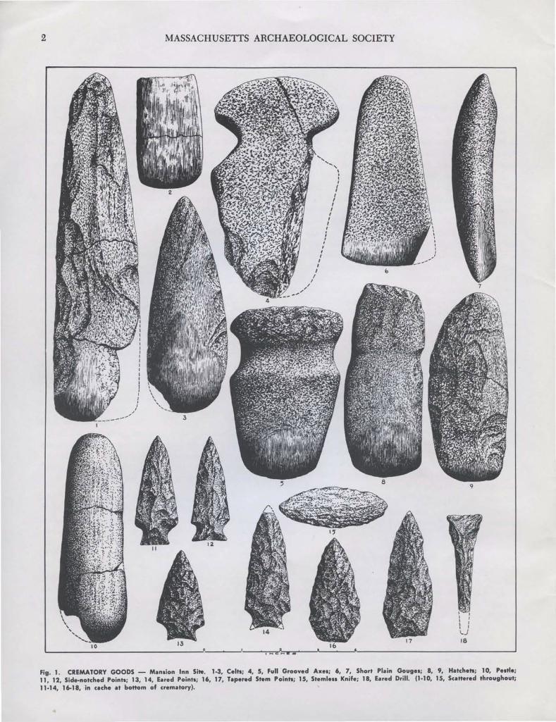
Excavating just beyond the crematory, the firstof many secondary burials was exposed. It contained but one artifact, a small copper ax (Fig. 2,#10). This lay in a rather large shallow accumulation of yellow sand, and was surrounded by a thincircle of red ochre. Adhering to the ax were fragments of bone (presumably human), covered withcharcoal dust. These, evidently, had become fusedtogether by fire, which indicated original deposition in the crematory.
On another evening, a heavy concentration ofcharcoal was located outside the crematory pit. Init appeared a fractured grooved ax, and a waterwashed stone 3 x 5 x 1" size, with one edge wornaway by rubbing. Both specimens were coveredwith red ochre stains. As the work of excavationprogressed, two more secondary burials were discovered at the edge of the crematory, badly damaged, their pits resting on fine yellow sand. In oneappeared 22 cache blades of from 2" to 3~" inlength. Most were fractured and in a state of disintegration, apparently caused by intense heat fromthe crematory fires. However, indication that theyhad been redeposited in this secondary burial wasevident from the fact that they were surrounded bya small circle of red powdered ochre. In the otherburial occurred 12 cache blades of the same sizeand condition as those of the first, also surroundedwith red ochre.
In another direction at one side of the crematory, a fifth secondary burial was uncovered, butthis one contained no red ochre. The buried artifacts consisted of 34 well made blades (probablypoints or knives), 1 x 3~" in size, and in excellentcondition. With them appeared a small amount ofburnt bone (presumably human), and charcoal.They had been carefully placed in the grave ingroups of 4 or 5 each, one group on top of another,with the points of some in one direction, and thoseof others in the reverse. In no case did the bladeslie crosswise, and the charcoal and bone fragmentscovered only about half of them. It should be notedthat 9 blades were of red felsite, 6 had a gray-bluetinge, and the balance a sandy gray color, probablyfelsite.
By this time, news of the discovery hadleaked out, in spite of our utmost caution. Beforelong, many intruders commenced to excavate. Theyopened more secondary burials and recovered someoutstanding large knife blades (Fig. 2, #3,4). (Inthe case of these two specimens, exhibit #3 appearsto be of Kineo felsite and #4 of Coxsackie Hint. Theformer is smeared with red ochre stains, and thelatter has incrustations of iron, possibly fromdecomposition of a pyrites strike-a-light-Ed.). Oneof the most significant recoveries made at this timewas a soapstone bowl, about 14 inches long with thecustomary lugs at either end. It appeared in asecondary burial along with stone blades of variouskinds. No potsherds, shell refuse, or bone artifactswere found in the crematory or in any of thesecondary burials. Many of the blades were madeof indigenous felsite; only two were of white quartz,one of which, a knife, is illustrated (Fig. 1, #15).
CONCLUSION
It seems likely that the large charcoal depositwas a crematory, where bodies of the deceased wereburned. Afterwards, bone residue and ash werescooped up and redeposited in secondary burials.These lay within an area about the crematoryextending outward from it about 40 feet. Evidently,the practice of placing implements - perhaps belonging to the deceased - first in the crematoryduring the burning, and then removing some ofthem for re-burial was followed. Also, additionalimplements were sometimes placed in the secondaryburials, some of which may have been deliberatelybroken or "killed," although many were undamaged.
Here is an inventory of our recovered artifacts,some of which were in fragments, but identifiable:Grooved Ax 13 Honing Stone 2Pestle (small) 8 Celt............................ 8Hatchets 2 Drill...................... 2Gouge 2 Rubbing Stone 18
Projectile Points and Knives 650
Watertown, Mass.June 22, 1961
APPENDIX
(Editorial Comment)
Here again at the Mansion Inn site is evidenceof a cremation complex similar to that reported atthe Boats, Wapanucket 6, and the Coburn sites. Atall three stations and as reported for the Coburnsite by Frank Kremp, Bulletin of the Massachusetts
4 MASSACHUSETTS ARCHAEOLOGICAL SOCIETY
II
,--, ,, ,, \, \, \, \I \
I \, ,I \, \
II
12
19
4
Fig. 2. SECONDARY BURIAL GOODS - Mansion Inn Site. I, Grooved Ax; 2, Plain Gouge; 3, 4, Stem Knives; 5, 6, Stemle.. Knives; 1, T Drill;8,9, Stem Scrapers; 10, Copper Ax; 11-13,20, 21 J.pered Stem Points; 14-16, E.-ed Points; 11, Red Ochre; 18, Sid....notched Point; 19, DiamondPoint; 22, Honing Stone
PROJECTILE POINTS AND THEIR CULTURAL SIGNIFICANCE 5
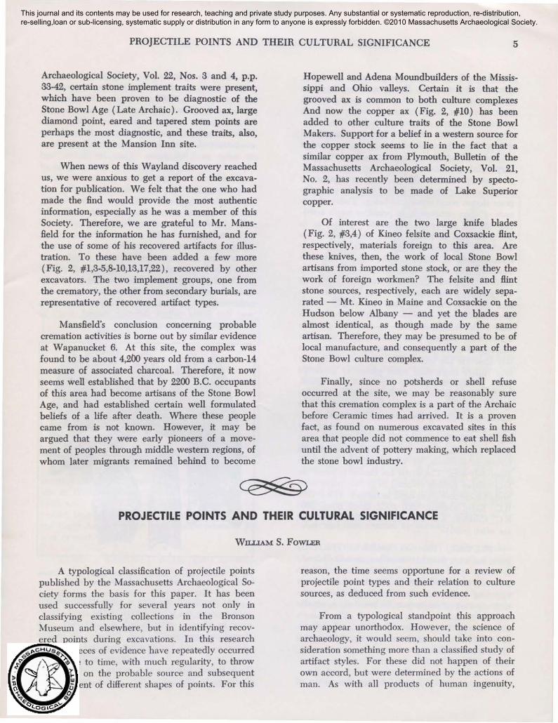
Archaeological Society, Vol. 22, Nos. 3 and 4, p.p.33-42, certain stone implement traits were present,which have been proven to be diagnostic of theStone Bowl Age (Late Archaic). Grooved ax, largediamond point, eared and tapered stem points areperhaps the most diagnostic, and these traits, also,are present at the Mansion Inn site.
When news of this Wayland discovery reachedus, we were anxious to get a report of the excavation for publication. We felt that the one who hadmade the find would provide the most authenticinformation, especially as he was a member of thisSociety. Therefore, we are grateful to Mr. Mansfield for the information he has furnished, and forthe use of some of his recovered artifacts for illustration. To these have been added a few more(Fig. 2, #1,3-5,8-10,13,17,22), recovered by otherexcavators. The two implement groups, one fromthe crematory, the other from secondary burials, arerepresentative of recovered artifact types.
Mansfield's conclusion concerning probablecremation activities is borne out by similar evidenceat Wapanucket 6. At this site, the complex wasfound to be about 4,200 years old from a carbon-14measure of associated charcoal. Therefore, it nowseems well established that by 2200 B.C. occupantsof this area had become artisans of the Stone BowlAge, and had established certain well formulatedbeliefs of a life after death. Where these peoplecame from is not known. However, it may beargued that they were early pioneers of a movement of peoples through middle western regions, ofwhom later migrants remained behind to become
Hopewell and Adena Moundbuilders of the Mississippi and Ohio valleys. Certain it is that thegrooved ax is common to both culture complexesAnd now the copper ax (Fig. 2, #10) has beenadded to other culture traits of the Stone BowlMakers. Support for a belief in a western source forthe copper stock seems to lie in the fact that asimilar copper ax from Plymouth, Bulletin of theMassachusetts Archaeological Society, Vol. 21,No.2, has recently been determined by spectographic analysis to be made of Lake Superiorcopper.
Of interest are the two large knife blades(Fig. 2, #3,4) of Kineo felsite and Coxsackie Hint,respectively, materials foreign to this area. Arethese knives, then, the work of local Stone Bowlartisans from imported stone stock, or are they thework of foreign workmen? The felsite and Hintstone sources, respectively, each are widely separated - Mt. Kineo in Maine and Coxsackie on theHudson below Albany - and yet the blades arealmost identical, as though made by the sameartisan. Therefore, they may be presumed to be oflocal manufacture, and consequently a part of theStone Bowl culture complex.
Finally, since no potsherds or shell refuseoccurred at the site, we may be reasonably surethat this cremation complex is a part of the Archaicbefore Ceramic times had arrived. It is a provenfact, as found on numerous excavated sites in thisarea that people did not commence to eat shell fishuntil the advent of pottery making, which replacedthe stone bowl industry.
PROJECTILE POINTS AND THEIR CULTURAL SIGNIFICANCE
WILLIAM S. FOWLER
A typological classification of projectile pointspublished by the Massachusetts Archaeological Society forms the basis for this paper. It has beenused successfully for several years not only inclassifying existing collections in the BronsonMuseum and elsewhere, but in identifying recovered points during excavations. In this researchcertain pieces of evidence have repeatedly occurredfrom time to time, with much regularity, to thrownew light on the probable source and subsequentdevelopment of different shapes of points. For this
reason, the time seems opportune for a review ofprojectile point types and their relation to culturesources, as deduced from such evidence.
From a typological standpoint this approachmay appear unorthodox. However, the science ofarchaeology, it would seem, should take into consideration something more than a classified study ofartifact styles. For these did not happen of theirown accord, but were determined by the actions ofman. As with all products of human ingenuity,
This journal and its contents may be used for research, teaching and private study purposes. Any substantial or systematic reproduction, re-distribution, re-selling,loan or sub-licensing, systematic supply or distribution in any form to anyone is expressly forbidden. ©2010 Massachusetts Archaeological Society.
6 MASSACHUSETTS ARCHAEOLOGICAL SOCIETY
each projectile point style was produced, no doubt,to meet a definite need. For upon the effectivenessof spear or arrow depended man's very survival.First, there was the problem of how best to attachpoints to the shaft, which perhaps from the beginning was the foremost factor in determining basalshapes. Then there was the consideration of whatmethod of hunting was to be used, whether forharpooning, javelin or dart throwing, spear jabbing,or arrow projecting. These too, were importantproblems to be resolved before suitable projectilepoint shapes could come into being. Today, thousands of years removed from primitive man's activities, we can only make constructive guesses as towhat went on in earlier times. Nevertheless, wewould be negligent indeed if we did not use ourhuman faculty of reason to make logical deductionsbased upon recovered evidence. We should not beindifferent, in our aesthetic appraisal of intriguingand beautiful point shapes, to the human motivesthat inspired them. In fact, we should try toassociate variously styled stone points with the menwho made them, and learn as much as possibleabout what bearing their cultures had upon theshaping of these points. Investigative thought inthis direction has lead in recent years to relativelyfirm beliefs concerning some phases of projectilepoint development in this part of New England.While this paper expresses the personal convictionsof the writer, it has been written after numerousdiscussions with other interested individuals. However, it can be no more than an approximation ofthe truth, as in archaeology we can only tend toprove something. For here we are dealing withunwritten evidence, of which we can never beabsolutely sure. The writer has chosen to name thefour culture periods referred to in this paper withprobable chronological dates as follows: Paleo, 7000B.C.; Early Archaic, 4500 B.C.; Stone Bowl, 3000B.G; Ceramic, A.D. 300. (Other names for severalare often used).
FLUTED, (Paleo or Ancient). This earlypoint has wide distribution on low excavated levelsin nearly every state in the Union, as well as inEcuador and Chile. It has hollowed out facesopposing each other. In New England it occurswith tapering or nearly parallel based sides, usuallyslightly ground or finely reworked. The base isconcave with basal corners generally well defined.In South America a modified type appears, as wellas the standard, having a short relatively wide stem,which is fluted on both faces.
Characterized by facial fluting this group of
points has been associated closely with charcoal orother organic samples having Carbon-14 measuresof approximately 10,000 years ago at Folsom, NewMexico and Lubbock, Texas; 9,000 years at Ipswich,Massachusetts (Bull Brook site); and 7,000 years inChile. The Sandia points of Sandia, New Mexicoare presumed to ante-date fluted points by perhapsas many as 3,000 years. They lay below andseparated from fluted points by a thick deposit ofcarbonate of lime droppings in a Sandia cave. However, this earlier arrival has been identified in onlya few places in the far West other than Sandia,which suggests only sparse occupation. On theother hand, the extensive distribution of flutedpoints indicates a prolific race of hunters, perhapsthe. first dominant culture to leave its mark uponthe country. It seems significant that fluted pointshave been found in Alaska, one on the north side ofthe Brooks Mountains, and broken specimens nearPoint Barrow lying below Eskimo culture remains,separated by a layer of clayey silt. However, whichway this fluted culture diffusion moved, north orsouth, still remains unresolved.
Fig. 3. FLUTED POINTS. Sources: 1·3, Bull Brook, Mass.; 4, TwinRivers, R. I.; S, Assowampsett, Mass.
As illustrated, the flute in some specimens mayextend nearly the whole length of the point. However, in others it extends only a short way, eventhough the stone may be flint. Probably the qualityof the stone used, flint or other material, had something to do with it. The narrow specimen fromTwin Rivers, Rhode Island, seems to indicate this.It is made from quartzite, which has a much
PROJECTILE POINTS AND THEIR CULTURAL SIGNIFICANCE 7
inferior concoidal fracture to that of flint. Thispoint may represent certain modifications, wqichundoubtedly took place toward the close of flutedpoint manufacture. Its parallel basal sides arecarefully reworked for :Ii", and one at least is eitherworn or intentionally ground, as is the case withmany flint specimens. Its narrow proportions seemto indicate a change is taking place from thebroader blades of most fluted points.
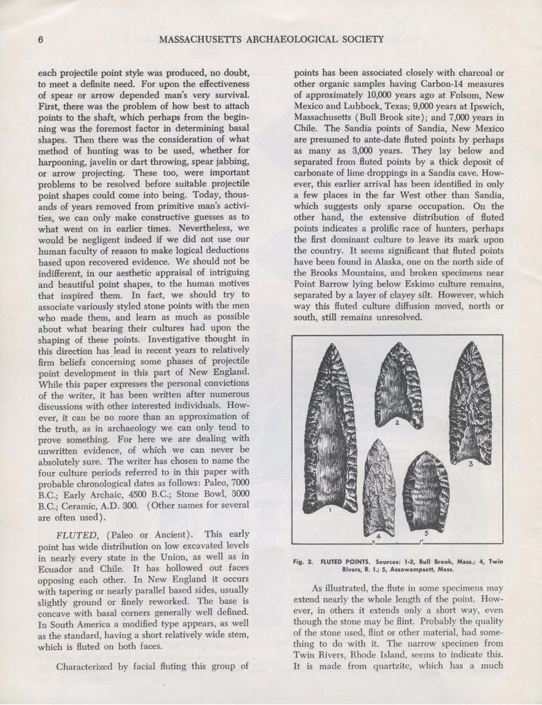
white sand level associated with small stone hearthremains and one Corner-removed #2 point, believed to represent end of the Paleo period. Thissuggests that racial continuity probably existsbetween Paleo and Early Archaic times, since in thelatter overlying zone at Titicut and elsewhere occuran increasing number of type #9 with type #8added. Also, in this zone appears type #5, which ispresent on similar Early Archaic levels at TwinRivers and Green Point sites in Rhode Island.
Fig. 5. CORNER·REMOVED #5, 8, 9.
CORNER-REMOVED #3, (Early ArchaicthroQ.gh Ceramic). Relatively narrow with a lengthof .1W' or more, this point seems to have been madeby various peoples in widely separated areasthroughout the last three culture periods of NewEngland. Its base has a short or long stem, as thecase may be, formed by removal of basal corners,and is often quite thick with a minimum of thinning. While only a few appear in the Early Archaiczone, their number increases rapidly throughout theremaining overlying zones. Therefore, this type isnot believed to be culturally diagnostic. Apparently,its convenient shape seemed to suggest itself to
'-- ----" _--=:..-_1· ---"'9 ~
5
Another feature these three types seem to havein common is their adaptability to the same methodof hafting. Excavated evidence at Twin Rivers suggests that first, the pith of the spear shaft wasremoved at the point end with a drill to a depth ofabout half an inch. Then a groove may have beensawed across the end. With these two operations,any of these points could have been inserted in theshaft and then secured by lashing.
Although these types at most sites seem to havean Early Archaic provenience, it is possible thatthey overlap into the following industrial cultureperiod of stone bowl making. For at Wapanucket 6,Assowampsett Lake, they occur with evidence ofearly Stone Bowl times (Late Archaic).
At Titicut type #9 first appears on the lowest
CORNER-REMOVED #5,8,9, (Early Archaic).These three different types have one thing in common: they occur at levels underlying Stone Bowlremains at several sites. Basically, they resembleeach other in that they are relatively long and havetheir basal corners sharply removed to form narrowtapering short stems, terminating in a slight bifurcation, a point, or a rounded end respectively, asillustrated. Tapering of the stem always starts fromwell indented shoulders.
CORNER-REMOVED #2, (Transitional)Paleo to Early Archaic). This type of point has awide stem nearly the width of the blade with almostparallel reworked sides, which produces only slightindentations or none at all where shoulders normally appear on other stem points. It is suggestiveof similar traits found on early Yuma points of theWest, thought to be associated there with flutedpoints. It has occurred infrequently in New England. At a Wayland site in Massachusetts it appeared at a low level underlying Early Archaic
remains (illustration, second specimen). At Titicutsite in Bridgewater it appeared in the low whitesand zone, thought to represent end of the Paleoperiod, because fluted points were absent, whereasthe Early Archaic point type, Corner-removed #9was present.
'-- ' _--',__'0·'::='-;;:: .......1
- Fig; 4. CORNER·REMOVED #2.
8 MASSACHUSETTS ARCHAEOLOGICAL SOCIETY
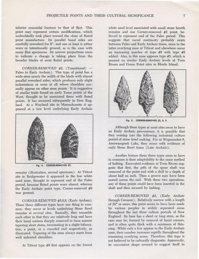
barbs, which are often serrated. Its stem is roundedand deeply bifurcated. At Titicut this type firstappears on the transitional white sand level with aC-14 measure of about 6,000 years ago, indicatingthe beginning of the Early Archaic, and continuesinto the overlying subsoil of this horizon. At theNunkatuset site it occurs deep in the subsoil underlying the Stone Bowl zone, identified as the EarlyArchaic horizon.
Fig. 8. BIFURCATED.
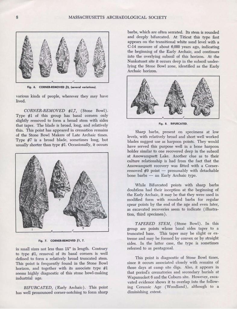
TAPERED STEM, (Stone Bowl). In thisgroup are points whose basal sides taper to atruncated base. This taper may be slight or extreme and may be formed by convex or by straightsides. In the latter case, the type is sometimesreferred to as pentagonal.
While Bifurcated points with sharp barbsdoubtless had their inception at the beginning ofthe Early Archaic, it may be that they were used inmodified form with rounded barbs for regularspear points by the end of the age and even later,as excavated recoveries seem to indicate (illustration, third specimen).
This point is diagnostic of Stone Bowl times,since it occurs associated closely with remains ofthose days at camp site digs. Also, it appears inthat period's crematories and secondary burials atWapanucket 6 and the Coburn site. However, excavated evidence shows it to overlap into'the following Ceramic Age (Woodland), although to adiminishing extent.
Sharp barbs, present on specimens at lowlevels, with relatively broad and short well workedblades suggest use as harpoon points. They wouldhave served this purpose well in a bone harpoonholder similar to one recovered deep in the subsoilat Assowampsett Lake. Another clue as to theirculture relationship is had from the fact that theAssowampsett recovery was fitted with a Cornerremoved #9 point - presumably with detachablebone barbs - an Early Archaic type.
'-- O'_-'~_I· __J
Fig. 7. CORNER·REMOVED #1, 7.
various kinds of people, wherever they may havelived.
Fig. 6. CORNER-REMOVED #3, (Ieveral variationl).
BIFURCATED, (Early Archaic). This pointhas well pronounced corner-notching to form sharp
CORNER-REMOVED #1,7, (Stone Bowl).Type #1 of this group has basal corners onlyslightly removed to form a broad stem with sidesthat taper. The blade is broad, long, and relativelythin. This point has appeared in cremation remainsof the Stone Bowl Makers of Late Archaic times.Type #7 is a broad blade, sometimes long, butusually shorter than type #1. Occasionally, it occurs
in small sizes not less than 1}f' in length. Contraryto type #1, removal of its basal corners is welldefined to form a relatively broad tnmcated stem.This point is frequently found in the Stone Bowlhorizon, and together with its associate type #1seems highly diagnostic of this stone bowl-makingindustrial age.
'-- ":0__"--_'_· -J
PROJECTILE POINTS AND THEIR CULTURAL-SIGNIFICANCE 9
o ,"
it seems likely that the pointed base was created tofacilitate hafting.
It should be noted that beautifully made 311
to 6" long, broad blades in the diamond shape, inone instance with irregular side notches above itstapering sides (illustration, Boats site), have recently appeared in Stone Bowl crematories orsecondary burials at Dighton, East Orleans, andWayland. Therefore, large blades like these shouldbe diagnostic of the Stone Bowl Age. Further, itseems possible that these large blades set the pattern for the smaller diamond points of later days.
Fig. 11. TRUNCATED AND LEAF.
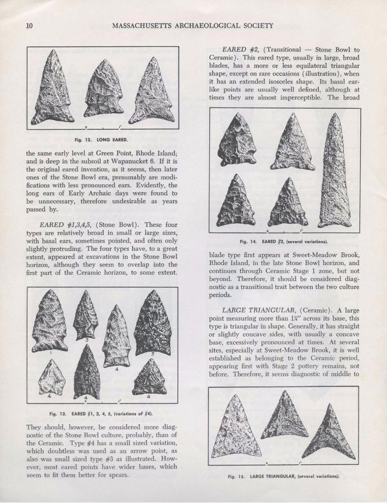
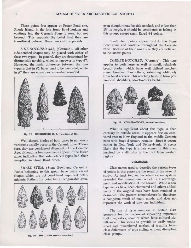
TRUNCATED, (Stone Bowl). This point typeis long and broad, having nearly parallel basalsides and a truncated base. Infrequently, it occursin small sizes. It appears in Stone Bowl cultureremains at Wapanucket 6 and in the Coburn site'scremation burials. Therefore, it should be diagnostic of Stone Bowl times. Its broad blade adds onemore style to broad blades of that industrial age.
LEAF, (Ceramic). In this type the base isrounded from co~vex sides, which converge without shoulders. Not much is known about this pointexcept it seems to be absent in Archaic and presentin Ceramic horizons; therefore, may be diagnosticof the latter. Its source at this time is not at allclear, but it may have been inspired by any ofseveral artifacts having a similar shape.
'--__"_U_H_C_A_T_f:D__.O-•__......._,·_--.,;'-;.:f:;.;,;A.;.F -'
o
Fig. 9. TAPERED.STEM, (a.veral variational.
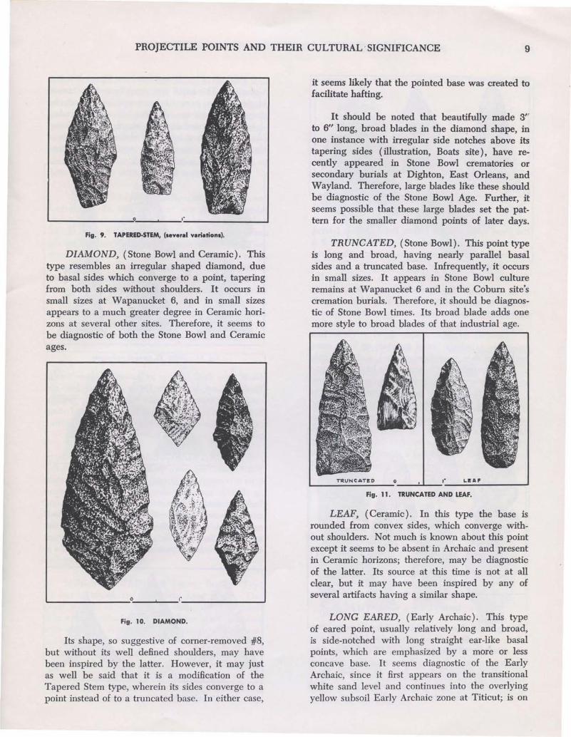
DIAMOND, (Stone Bowl and Ceramic). Thistype resembles an irregular shaped diamond, dueto basal sides which converge to a point, taperingfrom both sides without shoulders. It occurs insmall sizes at Wapanucket 6, and in small sizesappears to a much greater degree in Ceramic horizons at several other sites. Therefore, it seems tobe diagnostic of both the Stone Bowl and Ceramicages.
Fig. 10. DIAMOND.
Its shape, so suggestive of corner-removed #8,but without its well defined shoulders, may havebeen inspired by the latter. However, it may justas well be said that it is a modification of theTapered Stem type, wherein its sides converge to apoint instead of to a truncated base. In either case,
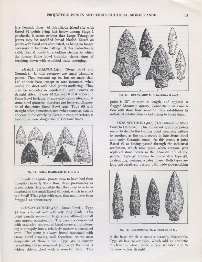
LONG EARED, (Early Archaic). This typeof eared point, usually relatively long and broad,is side-notched with long straight ear-like basalpoints, which are emphasized by a more or lessconcave base. It seems diagnostic of the EarlyArchaic, since it first appears on the transitionalwhite sand level and continues into the overlyingyellow subsoil Early Archaic zone at Titicut; is on
10 MASSACHUSETTS ARCHAEOLOGICAL SOCIETY
,"
EARED #2, (Transitional - Stone Bowl toCeramic). This eared type, usually in large, broadblades, has a more or less equilateral triangularshape, except on rare occasions (illustration), whenit has an extended isosceles shape. Its basal earlike points are usually well defined, although attimes they are almost imperceptible. The broad
blade type first appears at Sweet-Meadow Brook,Rhode Island, in the late Stone Bowl horizon, andcontinues through Ceramic Stage 1 zone, but notbeyond. Therefore, it should be considered diagnostic as a transitional trait between the two cultureperiods.
Fig. 14. EARED #2, (several variations).
Fig. 15. LARGE TRIANGULAR, (several variations).
LARGE TRIANGULAR, (Ceramic). A largepoint measuring more than lW' across its base, thistype is triangular in shape. Generally, it has straightor slightly concave sides, with usually a concavebase, excessively pronounced at times. At severalsites, especially at Sweet-Meadow Brook, it is wellestablished as belonging to the Ceramic period,appearing first with Stage 2 pottery remains, notbefore. Therefore, it seems diagnostic of middle to
Fig. 12. LONG EARED.
Fig. 13. EAR.ED #1, 3, 4, 5, (variations of #4).
They should, however, be considered more diagnostic of the Stone Bowl culture, probably, than ofthe Ceramic. Type #4 has a small sized variation,which doubtless was used as an arrow point, asalso was small sized type #3 as illustrated. However, most eared points have wider bases, whichseem to fit them better for spears.
EARED #1,3,4,5, (Stone Bowl). These fourtypes are relatively broad in small or large sizes,with basal ears, sometimes pointed, and often onlyslightly protruding. The four types have, to a greatextent, appeared at excavations in the Stone Bowlhorizon, although they seem to overlap into thefirst part of the Ceramic horizon, to some extent.
the same early level at Green Point, Rhode Island;and is deep in the subsoil at Wapanucket 6. If it isthe original eared invention, as it seems, then laterones of the Stone Bowl era, presumably are modifications with less pronounced ears. Evidently, thelong ears of Early Archaic days were found tobe unnecessary, therefore undesirable as yearspassed by.
'-- ---''--_,_'' ...J
PROJECTILE POINTS AND THEIR CULTURAL SIGNIFICANCE 11
late Ceramic times. At this Rhode Island site withEared #2 points lying just below among Stage 1potsherds, it seems evident that Large Triangularpoints may be modified broad bladed Eared #2points with basal ears eliminated, as being no longernecessary to facilitate hafting. If this deduction isvalid, then it points to a culture change in whichthe former Stone Bowl tradition shows signs ofbreaking down with modified traits emerging.
SMALL TRIANGULAR, (Stone Bowl andCeramic). In this category are small triangularpoints. They measure up to, but no more than1}4" at their base, except in rare instances, whenblades are short with basal points outflaring. Theymay be isosceles or equilateral, with convex orstraight sides. Types #1,3,4, and 6 first appear inStone Bowl horizons at excavated camp sites, and atstone bowl quarries; therefore are believed diagnostic of the entire Stone Bowl Age. Type #5 withstraight sides, sometimes somewhat concave, usuallyappears in the overlying Ceramic zone; therefore, isheld to be more diagnostic of Ceramic times.
Fig. 16. SMALL TRIANGULAR #1,3,4, S, 6.
Small Triangular points seem to have had theirinception in early Stone Bowl days, presumably asarrow points. It is possible that they may have beeninspired by the small Eared #4 point, which in effectis a Small Triangular with ears, that may have beendropped as unnecessary.
SIDE-NOTCHED #1,4, (Stone Bowl). Type#1 has a broad and relatively long blade. Thispoint usually occurs in large sizes, although smallones appear occasionally. The base is side-notchedwith extensive removal of basal corners, transforming it abruptly into a relatively narrow sidenotchedstem. This point is always found associated withStone Bowl remains, and therefore, seems mostdiagnostic of those times. Type #4 is narrowresembling Corner-removed #3, except the stem iswidely side-notched with a rounded base. This
1..- ---: ,_---''---_1· --'
Fig. 17. SIDE·NOTCHED #1, 4, (variations of each).
point is 1~" or more in length, and appears atRagged Mountain quarry, Connecticut, in association with stone bowl remains. This establishes itsindustrial relationship as belonging to those days.
SIDE-NOTCHED #3,6, (Transitional- StoneBowl to Ceramic). This important group of pointsseems to denote the turning point from one cultureto another, as the trait occurs in late Stone Bowland early Ceramic zones. In this sense, it joinsEared #2 as having passed through the industrialrevolution, which took place when ceramic potsreplaced stone bowls in the domestic life of thepeople. Type #6 appears to follow after type #3,as denoting, perhaps, a later phase. Both types arelong and relatively narrow with wide side-notching
I..--------,--~-'.--__~_____J
Fig. 18. SIDE·NOTCHED #3, 6, (variations of #3).
at the base, which at times is scarcely discernible.Type #6 has convex sides, which add an aesthetictouch to the whole, while in type #3 sides tend tobe more or less straight.
12 MASSACHUSETIS ARCHAEOLOGICAL SOCIETY
These points first appear at Potter Pond site,Rhode Island, in the late Stone Bowl horizon andcontinue into the Ceramic Stage 1 zone, but notbeyond. This supports the belief that they aretransitional between these two culture periods.
SIDE-NOTCHED #5,7, (Ceramic). All otherside-notched shapes may be placed with either ofthese two types. In general, they are determined bydistinct side-notching, which is narrower in type #7.However, the main difference between the twotypes is that in #5, bases tend to be truncated, while
.in #7 they are convex or somewhat rounded.
'--__5 ,0:..-. 1· -'
Fig. 19. SIDE-NOTCHED #5, 7, (variations of #5).
Well shaped blades of both types in numerousvariations usually occur in the Ceramic zone. Therefore, they are considered diagnostic of the CeramicAge, although a few specimens appear in the lowerzone, indicating that side-notched types had theirinception in Stone Bowl times.
SMALL STEM, (Stone Bowl and Ceramic).Points belonging to this group have many variedshapes, which are not considered important determinants. Rather, if a point has a recognizable stem,
Fig. 20. SMALL STEM, (several variations).
even though it may be side-notched, and is less than1~" in length, it should be considered to belong inthis group, except small Eared #4 points.
Small Stem points appear first in the StoneBowl zone, and continue throughout the Ceramiczone. Because of their small size they are believedto be arrow points.
CORNER-NOTCHED, (Ceramic). This typeapplies to both large as well as small, relativelybroad blades, which have well defined notches,some broader than others, extending obliquelyfrom basal corners. This notching tends to form pronounced shoulders, sometimes as barbs.
Fig. 21. CORNER·NOTCHED, (several variations).
What is significant about this type is that,contrary to outside areas, it appears first on excavated sites in New England in the middle Ceramiczone with Stage 2 pottery remains. Since it occursearlier in New York and Pennsylvania, it seemslikely that the type is a late comer in this area,inspired by a diffusion of the trait from westernregions.
DISCUSSION
Class names used to describe the various typesof points in this paper are the result of ten years ofstudy. At least two earlier classification systemspreceded the present one, which is a rearrangement and modification of the former. While a fewtype names have been eliminated and others added,many of the original ones have been retained asdesirable. The present nomenclature IS, therefore,a composite result of many minds, and does notrepresent the work of anyone individual.
The use of type numbers in certain classgroups is for the purpose of separating importanttrait diagnostics, some of which have cultural significance. This seems to provide an easily understood and remembered method of treating interclass differences of type styling without disruptingclass groups.
PROJECTILE POINTS AND THEIR CULTURAL SIGNIFICANCE 13
The illustrations are faithful copies of actualspecimens from sites in Massachusetts and RhodeIsland, except one Comer-removed #2 from NewHampshire, and one Side-notched #4 from Connecticut. However, they do not represent by anymeans all possible variations. Within any typegroup, other minor variations from those shownmay occur and should be expected. Also, type sizesmay vary within certain limits, as has been- indicated, and projectile points as illustrated do notrepresent exact size standards, only approximatethem.
In developing this classification, culture relationship has been recognized as an important factorin man's production of the different point styles.But even now, with what research has been accomplished, we are able only to see dimly which cultures apply to which types. However, with continued research, in time we may come to know agreat deal more about this problem.
One question frequently suggests itself: Whatconstitutes an arrow point as distinguished- from aspear point? Considerable difference of opinionmakes solution of this problem difficult. It has beenmaintained by some that because a point has a widebase and is comparatively heavy is no reason toclaim that it is not an arrow point. They argue thatarrow shafts in the beginning, at least, may not haveused feathers to guide the Hight. If this is so, thena heavier weighted tip made by point and an enlarged bulkier shaft at this end would have beenrequired to keep the arrow straight in flight, although restricted to shorter distances than arrowswith feathers. Recently, a 19" arrow of Indiansource of about 1790 from Norwell natives has beendonated by a Society member, in whose family thearrow and a 3' bow (now missing) have beenhanded down through six generations. It has aKl' diameter, and toward the point end expands to~". This shaft was used without feathers, andwould accommodate a narrow as well as a widebased point. Here is proof that featherless arrowswere used in historic times, as well as featheredones reported by early commentators. The featherless shaft may have been traditionally influencedfrom the remote past, and may have been the firstinvention.
If the enlarged tip end of a shaft was serviceable in the case of arrows, then certainly it wouldhave been equally so for spears, which presumably
were made without feathers. The enlarged shaftend would then have been useful in providing aproper seat for such wide based points as LongEared; Eared #1,2,5; Comer-removed #1,2; andother wide based types. Their extreme width wouldseem to suggest their use on spears rather thanarrows.
However, an arrow with feathers is a universalinvention of man, and must, therefore, be considered as a probability in the hunting equipment ofearly times. For this reason, the writer inclines tothe belief that Small Triangular and Small Stempoints proclaim without much doubt the arrival ofbow-and-arrow, doubtless with feathers, on levelswhere they first appear. Whether arrows with orwithout feathers were used before these smallpoints appear is a moot question, and probably willalways remain so.
Spear points, it seems, should be those largerand heavier points with bases measuring more thana half inch in width for shaft attachment. Halfinch or narrower bases usually found on Comerremoved #3 points would be adaptable for use onarrow shafts. Light weight and short points with ahalf inch or less base width like some Comernotched points, also were doubtless used on arrowshafts. On the other hand, some short but stubbyEared #4 points with a base spread of ~" or morebetween side-notching could better have beenhafted on a spear rather than an arrow shaft. Onesuch point is illustrated measuring only 1W' inlength. By this reasoning, a point to qualify for aspear need not have great length. The determinantseems rather to be a wide base spread of morethan ~" between side-notching, comer-notching,or corner-removing.
It is also possible that points having extremebasal shaft widths of one inch or more were sometimes used on large ceremonial spear shafts, or onjabbing spears, whose shafts must have been bulkyto make them sturdy. Because of this, diameter oftheir shafts must have been somewhat greater thanthat for thrown spears or javelins. Furthermore, itseems fair to speculate that small thrown spears ordarts were also in use, and were here before thearrival of bow-and-arrow. This might then accountfor the presence of smaller Early Archaic pointsoccasionally found on that early culture level.
Bronson MuseumJune 22, 1961
14 AN INTRODUCTION TO SOILS
ARTHUR C. LoRD, JR.
The purpose of this article is to present asimplified description of soils with particular emphasis on those factors with which archaeologistsare most concerned: the soil profile, rate of soilformation, and factors contributing to erosion.
Webster's dictionary defines soil as, "the loosematerial of the earth in which plants grow". Thesoil scientist desires a more extensive definitionbecause soil is a mixture of minerals, organic matter, air and water which may vary in depth from a
.few inches to hundreds of feet.
FORMATION
Soil is formed as a result of the combinedactivity of four different agents: I) parent material, 2) organic matter (vegetable and animal),3) climate, and 4) time. The possible combinationsof these factors are infinite, and, although no singleagent is responsible for the production of a soiltype, climate is the most important factor. Therefore, soils may be characterized in terms of threegeneral climatic processes: laterization, calcification, and podzolization. Laterization is a processof the hot-humid tropics which removes all of theelements, except iron and aluminum, from the soilby excessive rainfall and ground waters. Theprocess of removal of the elements by ground wateris called "leaching". The iron and aluminum compounds, hardened by leaching and tropical heat,produce a hard, brick-like laterite soil which is veryinfertile. Calcification is a process of the arid grasslands where rainfall is insufficient to produceleaching. Since the decayed grass produces a greatdeal of humus and the calcium and magnesiumhave not been leached out, these natural grasslandsproduce the most fertile soils in the world, of whichthe Chernozem is the best example. Podzolizationis a process of the cool and humid forest regions ofthe world, which includes New England. Organicmatter decays slowly in this climate producing athin humus zone with highly leached soil. Soil produced by this process is usually very shallow, andmay be only two or three feet deep unless based ondeeper glacial deposition. This soil is not fertile andrequires much attention to produce crops otherthan trees.
The type of soil produced is the result of morethan just the climatic processes. It also depends onthe other three agents: parent material, organicdebris, and time. Slope is of great importance when
considering the depth of the soil. If there is adequateslope and a lack of vegetation, erosion can and doesremove the topmost layer of the soil if not checkedby conservation methods. Of course, it is realizedthat climate is the single most important factor andthat climate is the main determinant of the degreeof leaching, the profile, and the fertility of the soil.The parent material is of importance as this is theraw material from which the various elementsoriginate. It determines what the texture of thesoil will be and also what nutrients will be available for plant life. The amount and type of organicmatter is a result of the climatic type. If animals,insects and worms are not present, the soil willbecome so hard packed that air and water will beunable to penetrate. In the formation of soils, timeis also of importance as the controls work veryslowly and most soils are not mature but in somestage of development. Realizing that erosion worksin reverse to time, the stage of a soil may be expressed as time minus erosion. A good rainstormmay remove from a plowed field which lies on aslope the amount of soil that all the other controlstook hundreds of years to develop.
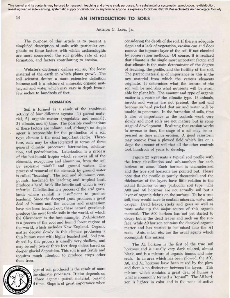
Figure 22 represents a typical soil profile withthe letter classification and sub-numbers for eachhorizon or zone. .Each horizon is characterizedand the true soil horizons are pointed out. Pleasenote that the profile is purely theoretical and thethicknesses of the layers have little relation to theactual thickness of. any particular soil type. TheAOO and AO horizons are not actually soil but alayer of organic debris on the surface. To be a truesoil, they would have to contain minerals, water andoxygen. Dead leaves, sticks and grass as well asroots make up the major source of this organicmaterial. The AOO horizon has not yet started todecay but is the dead leaves and such on the surface, while AO horizon contains the decayed organicmatter and has started to be mixed into the Alzone. Ants, mice, etc. are the usual agents whichaccomplish this mixing.
The Al horizon is the first of the true soilhorizons and is usually very dark colored, almostblack, and is a mixture of organic humus and minerals. In an area which has been plowed, the AOO,AO, and Al horizons have been mixed by the plowand there is no distinction between the layers. Thismixture which contains a great deal of humus iswhat is commonly termed a "topsoil". The A2 horizon is lighter in color and is the zone of active
This journal and its contents may be used for research, teaching and private study purposes. Any substantial or systematic reproduction, re-distribution, re-selling,loan or sub-licensing, systematic supply or distribution in any form to anyone is expressly forbidden. ©2010 Massachusetts Archaeological Society.
AN INTRODUCTION TO SOILS
SOIL PROFILE
15
True Soil
Zone ofLeaching
Zone ofAccumulation
~" ,l£o. ""
Aoo~----
Aor
AI
... -----A2
------, A3
I 81~--- - -
-< 82
... - - ---\. 83
C
D
Fig. 22.
Leaves and organic debris
Decomposed organic debris
Dark colored horizon, humus
Light colored zone, leachlno
Transition to B
Transition to A
Deeper colored horizon zone ofaccumulation
Transition to C
Crude Soil, many rocks
Unbroken Bedrock
leaching as both the humus and the minerals arebeing continually removed. The transition from Ato B is not a clear line but a gradual change; therefore, we include two zones of transition, the A3and Bl which are difficult to distinguish.
The B2 horizon is a deeper colored zone and isthe zone of accumulation. It is usually a deeperrusty red or a dark grey because the minerals andelements removed from the A horizon by groundwater have been concentrated here. These colorsmay result from iron, manganese or calcium compounds. This layer is quite often very hard and issometimes called a "hardpan" or a hardpan layer.Horizon C is not actually soil but broken rockrubble and contains no humus. Many parts ofMassachusetts are covered by a thick layer of rockand rock fragments, glacial till, which would provide a very thick C horizon. Horizon D is the solidbedrock which is buried deep in many parts ofMassachusetts while exposed at the surface in otherspots.
In Massachusetts, to be specific, the AOO andthe AO horizon are comprised of a thin layer ofleaves and decayed material over a brown or grey-
brown humus and mineral layer (AI). They, inturn, lie over a lighter, reddish brown A2 zone whichblends into a deeper reddish-yellow B zone. Thisusually is of much finer material containing moreclay than do the surface layers. The C layer iseither a result of glacial deposition or bedrock whichthen would be near the surface. If the area hasbeen plowed, the AOO, AO and Al horizons havebeen mixed and are found as a layer of browncolored topsoil that contains both minerals andhumus. There is a distinct break between thehumus-bearing topsoil, the transition, and the Bhorizon exposed underneath. This break whichcould be taken from the Al and A2 line then isactually the lower plow marks and is called bymany "the junction".
CLASSIFICATION
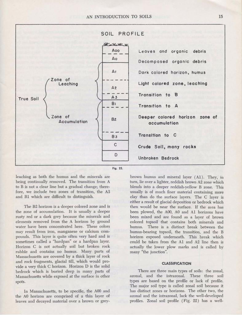
There are three main types of soils: the zonal,azonal, and the intrazonal. These three soiltypes are based on the profile or lack of profile.The major soil type is called zonal soil because ithas distinct zones or horizons. The other two, theazonal and the intrazonal, lack the well-developedprofiles. Zonal soil profile (Fig. 22) has a well-
16 MASSACHUSETTS ARCHAEOLOGICAL SOCIETY
developed profile which results from a definiteclimatic influence on well drained land.
The intrazonal soils are those in which thedevelopment of a profile has been impeded by thelack of drainage. Soils in a marsh, swamp or bogwould be examples of the intrazonal soils. Theazonal soils are those which lack a profile becausethere has not been sufficient time elapsed since theywere deposited to develop a mature soil profile.Examples of the azonal soils would be river deltas,alluvium deposits or active sand dunes.
. The zonal soils are the larger group, the mostuniversal, and also the one with which we will bemost concerned. The other two type~ must alwaysbe analysed as individual cases while, on the otherhand, the zonal soil types are universal and a podzolis a podzol whether it is found in Canada, U.S.S.R.,or the United States.
There are two distinct categories of the zonalsoils (Fig. ,23), the Pedocal and the Pedalfer, thecriteria for division being basically the amount ofrainfall. The Pedocal soil, a result of the calcification process of soil formation, is a soil of the aridregions of the earth and is not found in EasternUnited States. A Pedocal soil is characterized bycalcium accumulation near the surface as there isno leaching. The Grey Desert Soil is an example ofa soil of the very arid regions, deserts, and can be
fertile if given water, as many irrigated areas of theWest prove. The Chernozem Soil, the so-called"Black Earth", is the most fertile soil found on theearth. It is formed in the semi-arid grasslandswhich while arid enough to hinder leaching, stillhave enough rain to produce a good grass cover.The grass, in turn, supplies a great deal of organicmatter which when decayed produces a very thickhumus layer in the profile.
The Pedalfer soils, on the other hand, are soilsof the more humid regions, of which Eastern UnitedStates is an example, and therefore are highlyleached soils. The humus layer is much thinnerbecause of a forest cover, and the B horizon isreddish-yellow in color as there is accumulationhere of iron compounds. The subtypes of thePedaIfers include the Prairie Soils which are lessleached than the other PedaIfers. They are of thetransitional forest-grasslands and receive less rainfall than do the other Pedalfers. The Podzolic soilsare infertile soils of the cool-humid forest regions,which includes New England, and have a thin Ahorizon. While not on the diagram (Fig. 23), thesubtypes of the Podzols that are found in SouthernNew England are the Podzols of Cape Cod, theGrey-Brown Podzols of the Narragansett Bay Region of Rhode Island, and the Brown Podzols of therest of the area with the exception of the Berkshires. The last of the Pedalfers are the lateritic
SOIL CLASSIFICATION
Grasslands)
orest - Grasslands)
serts)
mid Forest>
soGAzona rov esert oll~
(Arid De
Pedocal(Arid)
Chernozem S~J.I$
Soli I Zonal (Semiarid
Prairie Soll~
(Humid F
Pedalfer Podzollc Solis(Humid) (Cool-Hu
In1razonal
:L aterlte Soils(Tropical For.s1s a Grasslands) 01
Fig. 23.
AN INTRODUCTION TO SOILS 17
soils of the humid tropics and subtropics, includingSouth Eastern United States. The soils are deepred in color from the iron concentration due to theleaching of the soils by excessive rainfall and heatof the region. It must be realized that these areonly a few of the types and subtypes, but these arerepresentative types and indicate the influence ofclimate and vegetation on soil.
EFFECTS OF EROSION ON SOIL
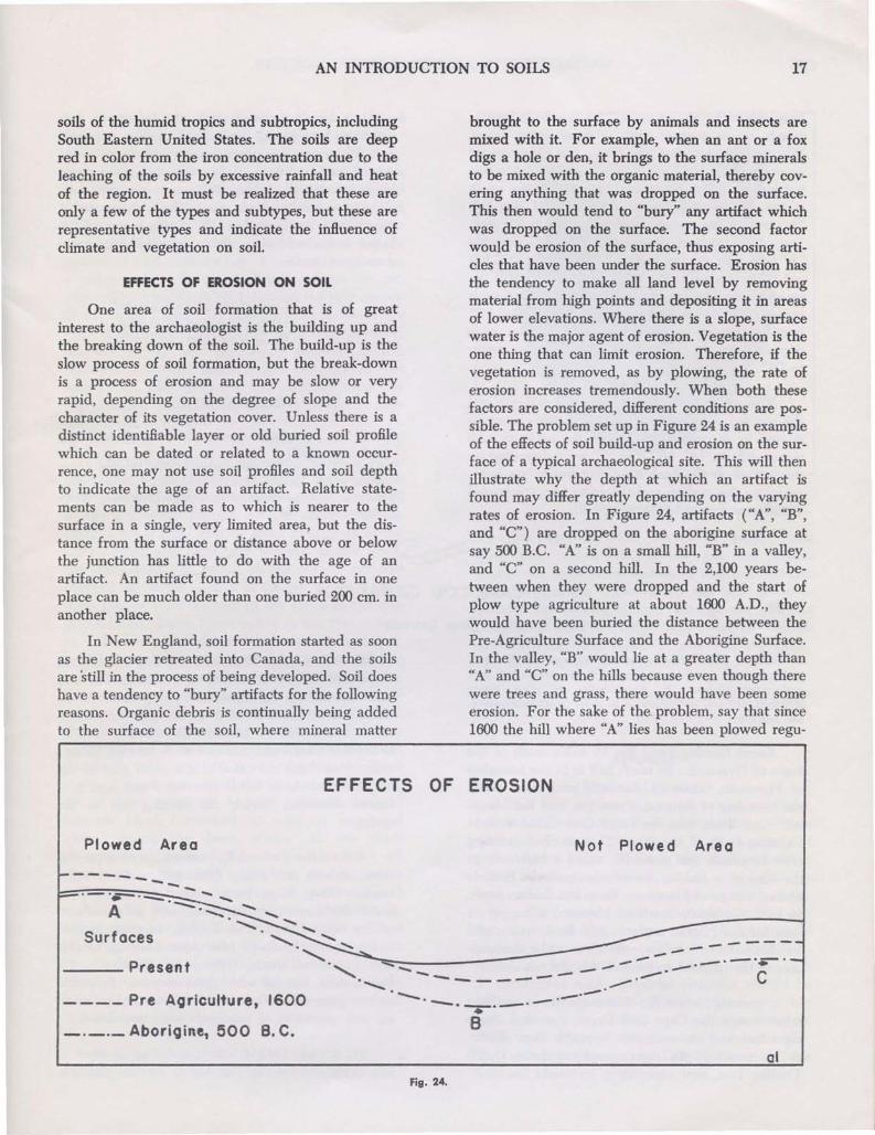
One area of soil formation that is of greatinterest to the archaeologist is the building up andthe breaking down of the soil. The build-up is theslow process of soil formation, but the break-downis a process of erosion and may be slow or veryrapid, depending on the degree of slope and thecharacter of its vegetation cover. Unless there is adistinct identifiable layer or old buried soil profilewhich can be dated or related to a known occurrence, one may not use soil profiles and soil depthto indicate the age of an artifact. Relative statements can be made as to which is nearer to thesurface in a single, very limited area, but the distance from the surface or distance above or belowthe junction has little to do with the age of anartifact. An artifact found on the surface in oneplace can be much older than one buried 200 em. inanother place.
In New England, soil formation started as soonas the glacier retreated into Canada, and the soilsare still in the process of being developed. Soil doeshave a tendency to "bury" artifacts for the followingreasons. Organic debris is continually being addedto the surface of the soil, where mineral matter
EFFECTS
brought to the surface by animals and insects aremixed with it. For example, when an ant or a foxdigs a hole or den, it brings to the surface mineralsto be mixed with the organic material, thereby covering anything that was dropped on the surface.This then would tend to "bury" any artifact whichwas dropped on the surface. The second factorwould be erosion of the surface, thus exposing articles that have been under the surface. Erosion hasthe tendency to make all land level by removingmaterial from high points and depositing it in areasof lower elevations. Where there is a slope, surfacewater is the major agent of erosion. Vegetation is theone thing that can limit erosion. Therefore, if thevegetation is removed, as by plowing, the rate oferosion increases tremendously. When both thesefactors are considered, different conditions are possible. The problem set up in Figure 24 is an exampleof the effects of soil build-up and erosion on the surface of a typical archaeological site. This will thenillustrate why the depth at which an artifact isfound may differ greatly depending on the varyingrates of erosion. In Figure 24, artifacts ("A", "B",and "C") are dropped on the aborigine surface atsay 500 B.C. "A" is on a small hill, "B" in a valley,and "c" on a second hill. In the 2,100 years between when they were dropped and the start ofplow type agriculture at about 1600 A.D., theywould have been buried the distance between thePre-Agriculture Surface and the Aborigine Surface.In the valley, "B" would lie at a greater depth than"A" and "c" on the hills because even though therewere trees and grass, there would have been someerosion. For the sake of the problem, say that since1600 the hill where "A" lies has been plowed regu-
OF EROSION
Plowed Area
-----..!.--,,,.,-:=-::-=-------- -
'_."--.---.:.~
A '-...Surfaces
___ Present
- --- Pre Agriculture, 1600
_._._ Aborigine, 500 B. C.
Not Plowed Area
-------...... ,...- ............. ---.---,.-........... --- --- -.-- C............... --- - ----- ~ ..--. .-.-.----._...-- .. --•
B
01
Fig. 24.
18 MASSACHUSETTS ARCHAEOLOGICAL SOCIETY
larly, while the hill where "C" lies has been kept inwoods or in pasture with a good grass cover.Whether the valley where "B" lies has been plowedor not matters little, as it is an area of depositionnot erosion. The hill where "A" rests is the resultof the erosion of 360 years, 1600 to 1960. On Hill"A", erosion has removed the soil down to the position of the artifact dropped at 500 B.C., so that"A" now rests on the surface. The hill at "C" hasnot been eroded at the same rate as "A" Hill because of the vegetation covering, and "C" remainsburied. "B" is even more deeply buried than "C"because the soil removed from Hill "A" has beendeposited in the valley and added further coverto "B".
This example illustrates how the soil depth andthe position of an artifact in a soil profile cannot betrusted as an indication of age for artifacts. Allthree artifacts, "A", "B", and "C" were deposited onthe surface at the same time, but today 0ne is exposed on the surface and the other two are buriedat different depths in the soil profile.
It is hoped that this short introduction to soilswill be of help in any future field work in archaeology. There are many fine texts on soils available inmost libraries. I have always found that the threebooks listed in the bibliography are very helpful onall matters dealing with soils. The Department ofAgriculture Yearbook for 1957, Soils, is one of thebetter books and is available free-of-charge fromyour congressman.
Central Michigan UniversityMount Pleasant, MichiganNovember 1960
BIBLIOGRAPHY
HIGBEE, ED., American Agriculture, (New York, Wileyand Sons, 1958).
MILLER, C. E., etc., Fundamentals of Soil Science, (NewYork, Wiley and Sons, 1951).
Soils, (U. S. Department of Agriculture Yearbook, Washington, D. C., 1957).
A CAPE COD CANAL POT
JESSE BREWER
Editor's Note: This remarkable recovery of sherds ata Stage 4 pot required courage, skill, an iron hand grip,and resourcefulness. It demonstrates to what extentarchaeologists will sometimes go in order to retrieve important artifacts.
Great Herring Pond lies 15 miles south of thetown of Plymouth. Its north half is in the townshipof Plymouth, while its southerly end falls withinthe township of Bourne. From this end the Manomet river Hows into the Cape Cod Canal a shortdistance south of the lake. This small connectingriver originally ran south for about a half mile tothe base of a plateau, on which stood the historicIndian village of Manomet. From this Indian town,in 1622, Governor Bradford obtained a supply ofcom for the Pilgrim settlers. "And here, today, stilllive four or five families, who claim to be descendants of the original Indians of this district.
Formerly, when the Manomet River reachedwhat is now the Cape Cod Canal, it took a sharpright turn and ran west into Buzzards Bay. There,at the mouth of the river, was located the DutchTrading Post, now completely restored.
In 1911 August Belmont & Co. dug the originalCape Cod Canal. It started in Buzzards Bay andcame directly up the Manomet River past the bend, "already referred to. Here, it cut through the plateauwhere once stood the Indian village, and passed onto Scroton Creek and Sandwich. A herring ladder,today, runs from the canal into a small part of theoriginal river from Great Herring Pond, and is atourist attraction during the herring run in thespring.
Before the Federal Government took over thecanal, it was just a big ditch with natural earthbanks. When large boats passed" through, greatwater disturbance would result, with much erosionof the canal banks. This erosion, in time, formednearly vertical banks on both sides. Throughout thisarea for several years, William W. Whiting and Ihad surface hunted with good success. Projectilepoints, grooved hammerstones, a beautiful polishedax, and quantities of potsherds were recovered.
In August, 1942, Whiting and I again went tothis canal site for the purpose of surface hunting.
This journal and its contents may be used for research, teaching and private study purposes. Any substantial or systematic reproduction, re-distribution, re-selling,loan or sub-licensing, systematic supply or distribution in any form to anyone is expressly forbidden. ©2010 Massachusetts Archaeological Society.
A CAPE COD CANAL POT 19
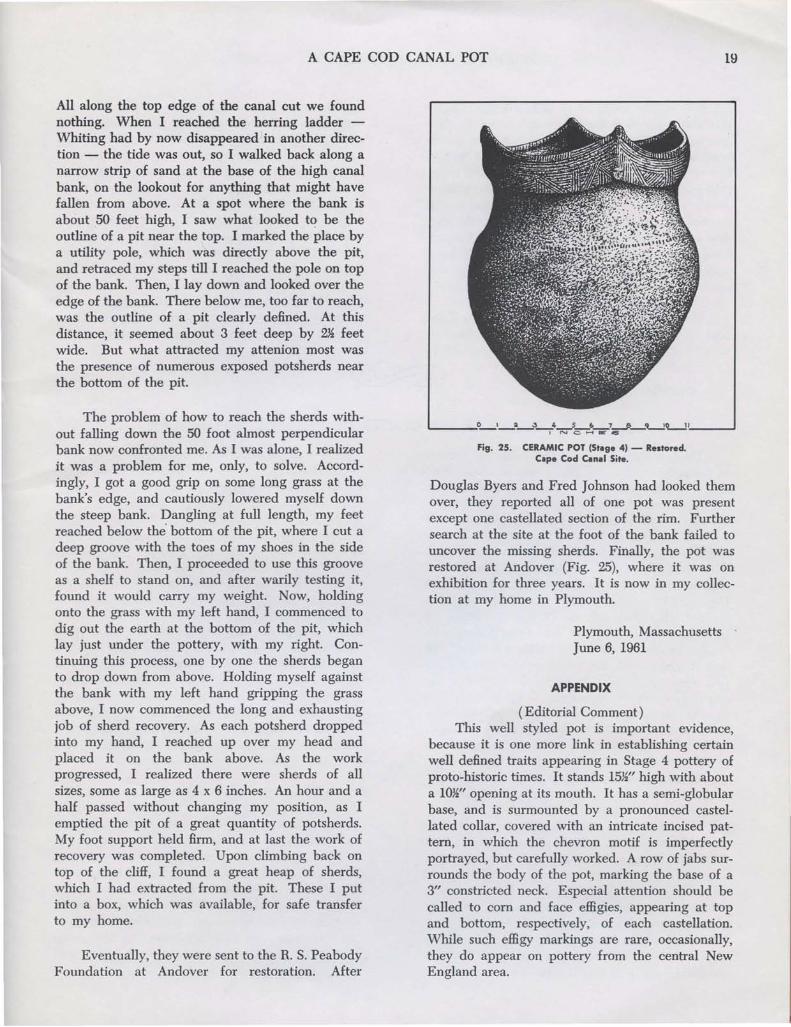
All along the top edge of the canal cut we foundnothing. When I reached the herring ladder Whiting had by now disappeared in another direction - the tide was out, so I walked back along anarrow strip of sand at the base of the high canalbank, on the lookout for anything that might havefallen from above. At a spot where the bank isabout 50 feet high, I saw what looked to be theoutline of a pit near the top. I marked the place bya utility pole, which was directly above the pit,and retraced my steps till I reached the pole on topof the bank. Then, I lay down and looked over theedge of the bank. There below me, too far to reach,was the outline of a pit clearly defined. At thisdistance, it seemed about 3 feet deep by 2~ feetwide. But what attracted my attenion most wasthe presence of numerous exposed potsherds nearthe bottom of the pit.
The problem of how to reach the sherds without falling down the 50 foot almost perpendicularbank now confronted me. As I was alone, I realizedit was a problem for me, only, to solve. Accordingly, I got a good grip on some long grass at thebank's edge, and cautiously lowered myself downthe steep bank. Dangling at full length, my feetreached below the' bottom of the pit, where I cut adeep groove with the toes of my shoes in the sideof the bank. Then, I proceeded to use this grooveas a shelf to stand on, and after warily testing it,found it would carry my weight. Now, holdingonto the grass with my left hand, I commenced todig out the earth at the bottom of the pit, whichlay just under the pottery, with my right. Continuing this process, one by one the sherds beganto drop down from above. Holding myself againstthe bank with my left hand gripping the grassabove, I now commenced the long and exhaustingjob of sherd recovery. As each potsherd droppedinto my hand, I reached up over my head andplaced it on the bank above. As the workprogressed, I realized there were sherds of allsizes, some as large as 4 x 6 inches. An hour and ahalf passed without changing my position, as Iemptied the pit of a great quantity of potsherds.My foot support held firm, and at last the work ofrecovery was completed. Upon climbing back ontop of the cliff, I found a great heap of sherds,which I had extracted from the pit. These I putinto a box, which was available, for safe transferto my home.
Eventually, they were sent to the R. S. PeabodyFoundation at Andover for restoration. After
L-_----"O_'_~_3_,4_"'-5C-~-_-7~-~O-','-__-,
Fig. 25. CERAMIC POT (Stage 4) - Restored.Cape Cod Canal Site.
Douglas Byers and Fred Johnson had looked themover, they reported all of one pot was presentexcept one castellated section of the rim. Furthersearch at the site at the foot of the bank failed touncover the missing sherds. Finally, the pot wasrestored at Andover (Fig. 25), where it was onexhibition for three years. It is now in my collection at my home in Plymouth.
Plymouth, MassachusettsJune 6, 1961
APPENDIX
(Editorial Comment)This well styled pot is important evidence,
because it is one more link in establishing certainwell defined traits appearing in Stage 4 pottery ofproto-historic times. It stands 15~" high with abouta lOW' opening at its mouth. It has a semi-globularbase, and is surmounted by a pronounced castellated collar, covered with an intricate incised pattern, in which the chevron motif is imperfectlyportrayed, but carefully worked. A row of jabs surrounds the body of the pot, marking the base of a3" constricted neck. Especial attention should becalled to corn and face effigies, appearing at topand bottom, respectively, of each castellation.While such effigy markings are rare, occasionally,they do appear on pottery from the central NewEngland area.
20 MASSACHUSETIS ARCHAEOLOGICAL SOCIETY
It is widely accepted in archaeological circlesthat this Stage 4 pottery was influenced by Iroquoian contacts of one kind or another. The castellated collar styling appears as an emergent trait inlate pre-lroquoian times in New York State,referred to as Owasco. It seems to have beendeveloped from this earlier elemental source andreached its zenith in Iroquoian ware. Similar evidence of preliminary rudimentary conceived castellated collared pots in New England is lacking,which seems to support the theory of an lroquoiansource for this coastal area.
However, to pick out some spot in New England - like the Guida site (Byers and Rouse) -
and say that all pottery ideas flowed from there toother sections of New England is misleading reasoning. It tends to discredit potters in other sectionsas having no ability to create and develop patternsand pottery contours for themselves. It seems muchbetter logic - perhaps nearer the truth - to creditpotters in other New England locals as being ashuman in their urge to invent, and as skillful inmaking beautiful pots, as those Guida artisans ofWestfield. In support of this statement, there willappear in future issues of this Bulletin additionalevidence in the form of restored pots recoveredfrom New England sites. These will serve to remindus that skillful performance goes hand in hand withinventive genius, not with supine imitation.
EDITORIAL
WAS THE GUIDA SITE THE CENTER OF CERAMIC INFLUENCE?
The last Bulletin of the Archaeological Societyof Connecticut, Number 30, is entirely devoted toan interpretation of evidence from the Guida Farmsite in Westfield, Massachusetts. In this lengthyreport, "A Re-examination of the Guida Farm," theauthors, Douglas S. Byers and Irving Rouse, haveattempted to establish this site as the source fromwhich ceramic traits and influence diffused into allregions of central New England during the finalCeramic (Woodland) period. To do this, they havecreated what they call the "Guida Tradition" ofceramics, which consists of Guida 'site pottery with"collars bearing the so-called Iroquois designs," butwith designs, which are "relatively complex and areso narrow and so closely spaced as to give a distinctively cramped appearance." They claim thatprior to this period other earlier pottery types are inevidence at Guida closely resembling similar onesfrom parts of New York State, including traditionsof Point Peninsula, East River, and Owasco. Also,they claim to find among the Guida sherds evidenceof ceramic traits from as far south as New Jersey.
After going into much detail to establish theirthesis, they conclude that even if a replacement ofGuida occupants by peoples from western andsouthern adjoining regions did not take place - notprobable - ceramic creative ideas flowed into theWestfield area from these outside culture areas. Ignoring important ceramic recoveries made by members of the Massachusetts Archaeological Society inthe Connecticut Valley and the Narragansett Archaeological Society in Rhode Island, all carefully re-
corded and reported, they refer only to isolatedrecoveries at Ipswich and on Cape Cod in which thesenior author was involved, as being too sporadically classified for more than passing notice. Because of this fallacious omission of important central New England evidence, which creates for thema ceramic void in this area, they are deluded intomaking an unreasonable suggestion. They wouldhave southern ceramic influences diffused into theWestfield area by what seems to this writer to be _a devious and unlikely overland route. They wouldhave us believe that New Jersey and East Rivercreative design motifs found their way up theHudson, then across to the Housatonic River, andfinally overland again over the Berkshire Hills intothe Westfield Valley. As a native of these regions,the writer feels certain that a more logical routewithout interference from natural mountain barrierswould have been up the Connecticut and WestfieldRivers by canoe; certainly a less circuitous route.
That ceramic influences were coming into NewEngland from outside regions is obvious because oftrait similarities, but to go to such length as foundin the report by Byers and Rouse in attempting toestablish their exact sources seems non-essential.The fact is that native potters of New England weredoubtless as human as anyone else, and modifiedwith inventive ingenuity the styling of vessel shapesand development of design motifs, which may havereached them from their neighbors. In fact, Byersand Rouse in their conclusion seem to agree withthis probability.
This journal and its contents may be used for research, teaching and private study purposes. Any substantial or systematic reproduction, re-distribution, re-selling,loan or sub-licensing, systematic supply or distribution in any form to anyone is expressly forbidden. ©2010 Massachusetts Archaeological Society.
creative ideas Bowed is irresponsible logic, for whocan say how ideas were carried. Furthermore, whoknows how many superior sites lie still buried oralready destroyed by modem building construction. It seems to this writer more logical and ofgreater value to concentrate on evaluation of pottery techniques and vessel styles for the purpose ofassigning them to the temporal stages of ceramicdevelopment to which excavation may dictate theybelong. Using site names, such as "Guida," todescribe potte~ types or what is worse, to name atradition of types, all for the express purpose ofpre-empting ceramic trait sources, is misleading andof questionable value. Once this is done, all similarware in the area, whether actually inftuenced by itor not, must of necessity carry the established name,as in this case, "Guida." Thus, a pot found byJesse Brewer near Cape Cod Canal must now becalled, according to Byers and Rouse: Guida Incised. How much more realistic it would be tofollow the system of classification, as used in theBronson Museum and by members of this Society,and list the Brewer pot as belonging to Stage 4, thelast of four stages of ceramic development. For,these stages are generally recognized by all, no matter how many place names may be assigned todifferent pottery types. After all, it is the chronological significance of pottery types, in the lastanalysis, which is the ultimate goal in research.And this may only be reached through controlledexcavation of pottery sites with due regard to stratigraphic position. of sherds. Place names allotted topottery types are just so ,much window dressing ofno chronological value. On the other hand, identification of pottery shapes, designs, and techniques,as related to their stratigraphic position, providessufBcient descriptive matter, it would seem, withoutplace names to confuse the issue, to permit allocation of variously styled pots to their respectivestages of development.
WAS THE GUIDA SITE THE CENTER OF CERAMIC INFLUENCE?
However, it would appear that they are following a questionable course of action in trying tosuperimpose an arbitrarily created Guida traditionover all central New Egland ceramics; a traditionincluding five different types: Guida Cord Marked,Fabric Marked, Incised, Plain, and Stamped. Ineffect, they are claiming that -here at this smallGuida site was a master group of potters - aridiculous hypothesis - who set the style for potters in other parts of Massachusetts and RhodeIsland. If this be so, then it also applies to northernareas of Connecticut and other adjacent regions.This conclusion is based on a study of only 664sherds, of which 54 are hom Guida's collection, 108from Brook's, 32 from Young's, 153 from the Springfield Museum, 224 from Phillips' coUection, thelargest single group (surface finds from the FrogHole area nearby - not &om the Guida site at all),and 93 from other sources. And yet, the authorssay that on this admittedly small Guida plot morepottery has been found than on any other site incentral New England; a fallacious statement whichcannot be substantiated. In making this claim theyhave deliberately ignored extensive work of theNarragansett Archaeological Society in their controlled excavation of the important Sweet-MeadowBrook pottery site in Apponaug, Rhode Island,reported in Bulletin of the Massachusetts Archaeological Society, Vol. 18, No.1. The reason given isbecause of failure there to allot classification placenames to each type of pottery found. Apparently,they consider unorthodox the c1assiflcation systemas used, which allots type variations to four stagesof development. Because of this, the site's severalthousand recovered sherds with a high degree ofstratigraphic reliahility become, in effect, nonexistent and of no account.
To say that any site, no matter how strategically located or how well supplied with highlysignificant pottery types, is the source from which
~NOTICE
It is with great pleasure that we announce theaddition of a new member on the staff of theBronson Museum, Dr. Joseph H. Waters. A graduate of the University of Michigan, he will make hisheadquarters at the museum after July 25th. Hisinterest is in the field of paleo-biology and he willmake a study of the fauna associated with prehistoric man in the Northeast.
You can assist in this valuable study by sendingto the Bronson Museum all bone material encoun-
tered in the course of your field work this summer.It is important that as much data as possibleaccompany this material. Please identify the site,the associations with which the bone was found,depths, type of soil, approximate distance to nearestwater (fresh or salt), etc.
At a later date more detailed information willbe published. Your cooperation in this study isearnestly solicited.
Maurice Robbins, Museum Director