Embed Size (px)
Citation preview
Chapter 1
Introduction
R.G. Cooper
From:Cooper, R.G. (2007) Mass Movements in Great Britain, Geological Conservation Review Series, No. 33, Joint Nature Conservation Committee, Peterborough, 348 pages, ISBN 978 1 86107 481 2For more information see: http://www.jncc.gov.uk/page-3015

Mass movements in context
3
MASS MOVEMENTS IN CONTEXT
Mass movements in the Britishcontext
Jones and Lee (1994) describe ‘mass movement’as ‘a broad spectrum of gravity[-driven] slopemovements’, of which the larger discretemovements are generally described as ‘land-slides’.
These mass-movement phenomena are amajor influence on much of the landscape ofGreat Britain, but vary considerably in scale.Some mass-movement processes are shallow(operating near the land surface), slow, andaffect large areas. For example, ‘soil creep’ hasbeen taking place on nearly all terrestrial slopessince the retreat of glaciers during the DevensianStage (the last glacial period of the PleistoceneEpoch in Britain, which ended about 11 500calendar years ago). Similarly, many landscapes(e.g. Dartmoor) are mantled by ‘solifluction’sheets of sediment (slow downslope-movingsaturated soil or rock debris), the process thatcreated them usually being ascribed to formerperiglacial (tundra-like) climatic conditions.
At the other end of the scale are deep-seated‘landslides’, whose occurrence under presentclimatic conditions in Britain is relatively rareboth areally and temporally (except on parti-cular stretches of the east and south coasts).Many of these have clearly taken place in thepast under conditions more conducive to massmovements and are very widespread. Thesemass-movement features are the principalsubject of the present volume.
A study undertaken in 1984–1987 for theformer Department of the Environment (DoE)by Geomorphological Services Ltd (GSL; pub-lished in 1988) in association with RendelPalmer & Tritton, that produced an inventory of8835 landslides in Great Britain has beenanalysed by Jones and Lee (1994). A majorconclusion drawn from the analysis is that mostinland landslides in Great Britain are relict butdormant (i.e. capable of being re-activated byengineering works, building or other disruptiveactivities). In contrast, coastal landsliding is apresent-day process, possibly associated withrising sea level and drainage.
A particular value of the inventory has beenthe provision of information for local andregional planners (Clark et al., 1996), who haveto deal with the consequences of landslides –
present-day, recent and relict – in relation toland-development applications.
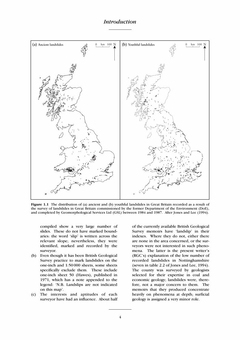
No other Geological Conservation Review(GCR) volume has had the benefit of such amajor survey of the features with which it isconcerned carried out by another organizationat a critically important time. The survey tookplace around the time of the period of GCR field-work in the 1980s. The GSL survey, however,was concerned with landslides that have beenmentioned or shown in documents. Thereforeit does not purport to be a complete inventoryof known landslides in Great Britain. Thedistribution of landslides identified by thesurvey, described as ‘ancient’ and ‘youthful’, isshown in Figure 1.1.
The present writer (RGC) was involved as acollector of data for north-east England in theGSL exercise, which led to the production of thedistribution map (Figure 1.1). It was clear thatwhen plotted on a 1:125 000 scale map, thedistribution of reported landslides in north-eastEngland alone was likely to be a very poor rep-resentation of the true distribution of landslidesactually identifiable in the field. A major reasonfor this was that landslides were not recordedequally well in the different surveyed areas,creating apparent, but not actual, demarcationsof high- and low-density areas of landslides (seebelow). The demarcations, as recorded in theliterature, often correlated to the boundariesbetween the various map areas of individualBritish Geological Survey maps, memoirs, andMineral Assessment Reports. Examples includeda cluster of landslides in North Yorkshireimmediately west of Ripon, another aroundBarnard Castle in County Durham, and a grouparound Bellingham in Northumberland. Since itis unlikely that landslide density correlates toBritish Geological Survey map-sheet areas, thismust indicate unevenness in the documentationbetween the sheets, memoirs or reports foradjacent areas. There are several reasons forsuch unevenness:
(a) It is clear that for areas surveyed up to sometime in the 1930s, landslides were simplynot marked on the resulting publishedBritish Geological Survey sheets. Examina-tion of the one-inch sheets of the NorthYork Moors area produced from surveysmade by C. Fox-Strangways between 1880and 1910 reveals no landslides at all. Yetthe six-inch maps from which they were
Introduction
4
compiled show a very large number of slides. These do not have marked bound-aries: the word ‘slip’ is written across therelevant slope; nevertheless, they wereidentified, marked and recorded by thesurveyor.
(b) Even though it has been British GeologicalSurvey practice to mark landslides on theone-inch and 1:50 000 sheets, some sheetsspecifically exclude them. These includeone-inch sheet 50 (Hawes), published in1971, which has a note appended to thelegend: ‘N.B. Landslips are not indicatedon this map’.
(c) The interests and aptitudes of eachsurveyor have had an influence. About half
of the currently available British GeologicalSurvey memoirs have ‘landslip’ in theirindexes. Where they do not, either thereare none in the area concerned, or the sur-veyors were not interested in such pheno-mena. The latter is the present writer’s(RGC’s) explanation of the low number ofrecorded landslides in Nottinghamshire(seven in table 2.2 of Jones and Lee, 1994).The county was surveyed by geologistsselected for their expertise in coal andeconomic geology; landslides were, there-fore, not a major concern to them. Thememoirs that they produced concentrateheavily on phenomena at depth; surficialgeology is assigned a very minor role.
Figure 1.1 The distribution of (a) ancient and (b) youthful landslides in Great Britain recorded as a result ofthe survey of landslides in Great Britain commissioned by the former Department of the Environment (DoE),and completed by Geomorphological Services Ltd (GSL) between 1984 and 1987. After Jones and Lee (1994).
Mass movements in context
5
Taking a national view, even where ‘landslip’ canbe found in the index of a British GeologicalSurvey memoir, recorded coverage of such massmovements is very variable. The area under consi-deration may contain a single large and obviousslide, recorded as such and which a surveyorcould hardly fail to mention, but smaller move-ments in the region may be overlooked or neg-lected. Alternatively, an area may have no majormass movements, but the surveyor may have aparticular interest in landslides, perhapsbecause of Quaternary research interests, and somay record comparatively many more occur-rences. Differences in the interests and apti-tudes of surveyors is the only tenable explana-tion of why some of the recently surveyed one-inch and 1:50 000 sheets of Northumberland arereplete with landslides (sheet 13 (Bellingham)has 71) while some of the adjacent sheets, withsimilar geology and comparable terrain – but dif-ferent surveyors – show none at all.
Similar observations were made about otherparts of the country by other collectors of datafor the exercise, leading Jones and Lee (1994) toobserve that ‘the patchiness of the distributionraises questions as to the extent to which theconcentrations displayed in the map [hereFigure 1.1] reflect the true pattern of landslideson the ground as against spatially variablereporting’. They continue:
‘It now seems certain that the pattern merelyhighlights those landslides which happen tohave been investigated, mapped and reported,and the extent to which the total availablecorporate knowledge of landsliding wastapped by the survey. It is undoubtedly truethat many reports of landslides publishedin obscure journals and old newspapers werenot accessed by the survey, and the same istrue of the data held in the files of numerousindividual professionals, companies andeven some national organizations. It mustalso be stressed that there must be numerousother landslides that have not yet beenrecorded because they exist in remote areas,are concealed by woodland, are relativelyinsignificant or have yet to be actuallyrecognized as landslides. This is clearlyillustrated by the results of the ... AppliedEarth Science Mapping of the Torbay area(1988) which raised the total of known andreported landslides from 4 to 304. Even inthe South Wales Coalfield, which has been
the subject of a major landslide inventoryexercise by the British Geological Survey, adetailed mapping programme in the Rhonddavalleys resulted in an increase in the numberof recorded landslides from 102 to 346.Clearly, in some areas, the harder you lookthe more examples you find. Indeed,extrapolation leads to the inevitable conclu-sion that the actual number of landslides inGreat Britain is many times in excess of the8835 recorded so far by this survey.’
The Torbay study referred to is described inGeomorphological Services Ltd (1988) andDoornkamp (1988). As stated by Jones and Lee(1994), the pattern of landslides displayed onthe map (Figure 1.1) must be treated withcaution in that it reflects under-representation ofthe true pattern, as an artefact of investigativeinterests and recording bias.
Mass movements in the Europeancontext
A large amount of research has been carried outon mass movements in Europe, particularly inrelation to three broad factors: climate, topography and geology. It is worth noting,however, that this tripartite division does notcreate exclusive, distinct categories. Geologyand topography, in particular, are intimatelylinked, with the geology (lithology andstructure) controlling the topography in somedetail. Also, few mass movements can beascribed to a single causal factor, or even to asingle type of causal factor.
(a) Climatic factors
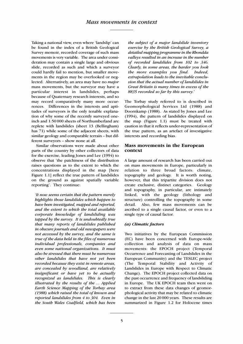
Two initiatives by the European Commission(EC) have been concerned with Europe-widecollection and analysis of data on massmovements: the EPOCH project (TemporalOccurrence and Forecasting of Landslides in theEuropean Community) and the TESLEC project(The Temporal Stability and Activity ofLandslides in Europe with Respect to ClimaticChange). The EPOCH project collected data onthe past occurrence and frequency of landslidingin Europe. The UK EPOCH team then went onto extract from these data changes of geomor-phological activity that may be related to climaticchange in the last 20 000 years. These results aresummarized in Figure 1.2 for Holocene times
Introduction
6
based on dates of named landslides in the UK and for selected European countries,respectively (Brunsden and Ibsen, 1997; Ibsenand Brunsden, 1997). They suggest that land-slide activity may be related to specific climaticperiods and that the existing knowledge of thiscould be substantially improved.
The TESLEC project has been concerned withthe effects and modelling of climate change onmass movements in Europe. This has involvedcontinued collation of data on the pastdistribution of landslides. This work has shownthat there are few decades when landslide eventshave not occurred in certain regions such as theSpanish Pyrenees and Barcelonette in theFrench Alps (Brunsden et al., 1996a).
The ‘Landslide Recognition’ survey (Dikau etal., 1996; the production of the survey was aninitial objective of the TESLEC project), and theDoE review revealed that in Great Britain themajor problem with respect to climate changescenarios is the potential for the re-activation ofdormant landslide complexes, rather than thepotential for first-time slides. By far the biggestpotential problem is the possibility that climatechange might generate widespread movement inthe very large landslide complexes that lie at thefoot of many of the escarpments in Mesozoicstrata. These complexes are, however, ratherrare on Chalk, for example the Chiltern Hills,Salisbury Plain and the Marlborough Downs,and along the North and South Downs.However, where clay is exposed at the base of aslope in Chalk strata, occasional landslide
complexes are to be found, for example theCastle Hill landslide at the entrance of theChannel Tunnel, the coastal termination of theNorth Downs at Folkestone Warren (seeChapter 7), the Dorset coast, and inland atBirdsall Brow in North Yorkshire.
(b) Topographical factors
The investigations of climatic factors alsorequired other influences on mass movementsto be identified, such as unloading, sea-levelrise, seasonal ground freezing, and caprockloading (Brunsden and Ibsen, 1997). However,the European chapters of a worldwide survey ofthe extent and economic significance of land-slides (Brabb and Harrod, 1989) point to theover-riding importance of individual high-intensity weather events, rather than climatictrends, as a precipitating factor for many massmovements. As stated, this has happened inGreat Britain, but only rarely. However, a land-slip in Yorkshire in 1755 took place 149 daysafter a very high-intensity, short-duration, smallarea rainfall event. The reason for this time-lagis not known, but it is within the range of flow-through times from precipitation of water on theground surface to its emergence at groundwater-fed springs in the area. An earthquake canprobably be ruled out as the immediate triggerof this landslide (Cooper, 1997).
France (Flageollet, 1989) has importanttopographical differences from Great Britain,including relatively new mountain ranges with
Figure 1.2 Indicative periods of major landslide activity in Europe derived from EPOCH data (c = radiocarbon(C14) dates; D = important individual dates from the historical record). After Brunsden and Ibsen (1997).
Mass movements in context
7
steep, high slopes, such as the Alps and thePyrenees. This topography leads to a similarrange of types of mass movements to GreatBritain, but the proportions are different.Particularly instructive are the variations of styleof failure along the Bessin Cliffs on the northcoast of Normandy, at Pointe du Hoc, Raz de laPercée, le Bouffay, le Chaos and Cap Manvieux(Maquaire and Gigot, 1988).
(c) Geological factors
Generally, where areas of Europe have geolo-gical situations not found in Great Britain, theyalso have types of mass movement not foundthere. The most obvious case is the quickclaydeposits of Norway and Sweden, where marineclays deposited during Holocene times havebeen uplifted isostatically to become part of theland surface (Gregersen and Sandersen, 1989).Since emerging from the sea, these depositshave been subject to subaerial erosion, and thesalt water has leached out from the soil matrix.This leaching increases the sensitivity (st) of theclay from, typically, an st value of 3–6, to a valuegreater than st = 20. When the salt content fallsbelow 1 g l–1, the clay becomes a quickclay. An unleached marine clay remains plastic on re-moulding, but a quickclay can transform intoa liquid (Bjerrum, 1954; Bjerrum et al., 1969).
Norway also has a large area of hard-rockmountains, liable to rockfalls and rockslides,rather like the Scottish Highlands.
Mass movements in the globalcontext
From the global perspective, mass movements inGreat Britain are unremarkable for their size,frequency, the hazards they pose, and their over-all variety. They are, perhaps, remarkable for thesmall proportion that are currently active, andconversely for the large proportion that aregenerally attributed to past climatic conditionsrather than those of the present day, in particularperiglacial conditions and immediate post-glacial conditions.
The reasons for this limited manifestation ofmass movements here are not hard to find. TheBritish Isles are not located close to a tectonicplate boundary, and have not been subject tovolcanic activity or significant seismic activity formany millions of years, so these potentialtriggering mechanisms do not play a major role.
Isostatic re-adjustment to the melting of themost recent Quaternary glaciers, and retreat ofthe last ice-sheet, may still produce minor earth-quakes, but these are infrequent, and hardly ofsignificance even in the triggering of the fewactive mass movements that are located in theScottish Highlands.
The principal limiting factor for British massmovements seems to be available relief. Thehighest point in Great Britain, the summit ofBen Nevis, reaches only 1343 m above OD; long,steep slopes are, therefore, something of a rarity.However, Great Britain’s steep slopes in uplandareas have been the sites of debris flows, butcomparatively only a few rockfall avalanches.
Great Britain’s temperate maritime climatehas seldom produced extremes of rainfallcapable of giving rise to a large-scale spate ofmass-movement events in an area over atimescale of a few hours. This has been knownto happen, for example on Exmoor in August1952 (Gifford, 1953; Delderfield, 1976), butsuch events are very uncommon, althoughclimate change may increase their frequency inthe future. Likewise, although solifluction hasbeen an important mass-movement processacross much of Great Britain, it is only in theextremes of upland Britain that conditions aresufficiently cold for periglacial processes such as solifluction to be currently taking place(Ballantyne and Harris, 1994).
On the other hand, Great Britain has animmense variety of landforms, which occur onbedrock of varied geological age and reflectdifferences in lithology (rock-type) and geolo-gical structure (such as faults and folds). Thisvariety has given rise to slopes that, in valley-sides, expose rocks of greatly varying resistanceto erosion, and so produce a variety of degreesof slope steepness. Many slopes of the uplandareas have been steepened relatively recently byglacial erosion. Likewise many kilometres of theBritish coast consist of vertical or sub-verticalcliffs, of variable height. As would be expected,these features have led to the development of a great number of mass-movement sites. Whilethe majority are unremarkable, collectively theydemonstrate a variety of features associated withQuaternary erosion, scarp retreat, and landscapeshaping.
There is, however, one aspect of the massmovements in Great Britain that has had asubstantial, and possibly disproportionate,influence globally. This is their role in the
Introduction
8
development of knowledge of mass movements,their mechanisms and their countermeasures(Hutchinson, 1984). Thus, one of the mass-movement sites chosen for the GCR includes,arguably, the first ever large-scale landslide to be described by geologists, the Bindon land-slide, part of the Axmouth–Lyme Regis mass-movement GCR site. In addition, a long series of studies of the behaviour of London Clay(Eocene-age deposits) has illuminated the mass-movement behaviour of all clay strata.More recently, the recognition of toppling as a separate and distinct type of slope failure has depended upon the study of Britishexamples.
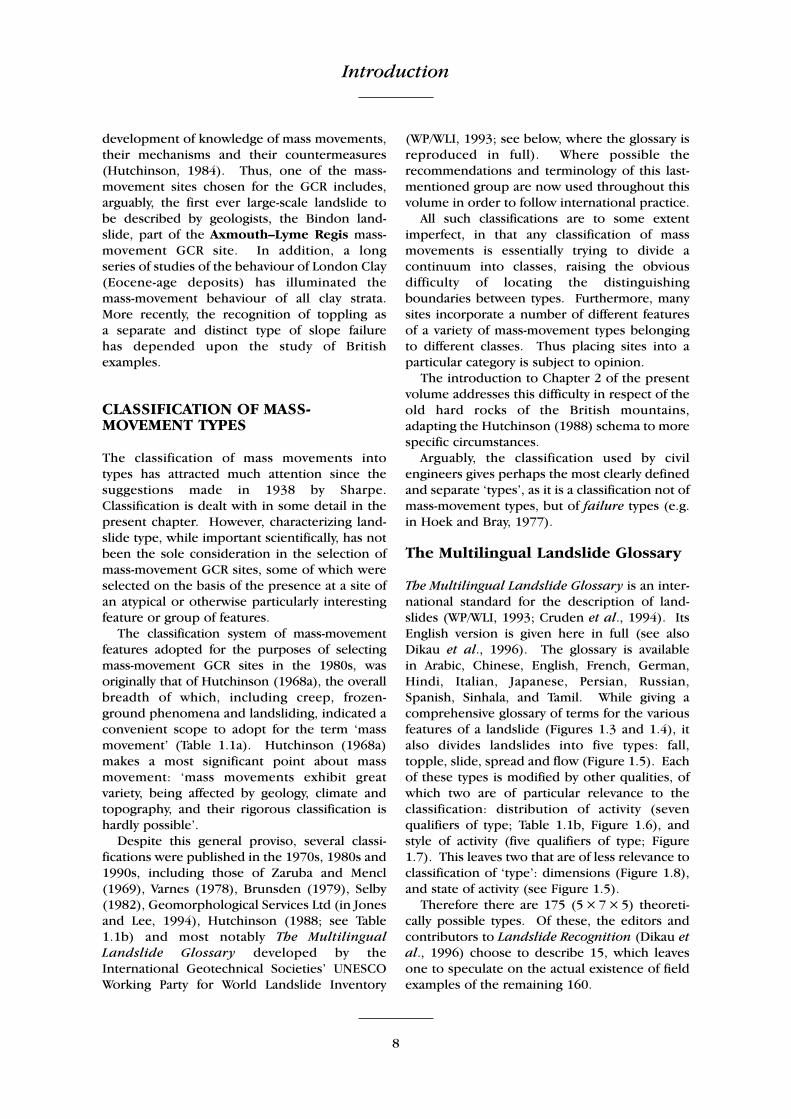
CLASSIFICATION OF MASS-MOVEMENT TYPES
The classification of mass movements into types has attracted much attention since thesuggestions made in 1938 by Sharpe.Classification is dealt with in some detail in thepresent chapter. However, characterizing land-slide type, while important scientifically, has notbeen the sole consideration in the selection ofmass-movement GCR sites, some of which wereselected on the basis of the presence at a site ofan atypical or otherwise particularly interestingfeature or group of features.
The classification system of mass-movementfeatures adopted for the purposes of selectingmass-movement GCR sites in the 1980s, wasoriginally that of Hutchinson (1968a), the overallbreadth of which, including creep, frozen-ground phenomena and landsliding, indicated aconvenient scope to adopt for the term ‘massmovement’ (Table 1.1a). Hutchinson (1968a)makes a most significant point about massmovement: ‘mass movements exhibit greatvariety, being affected by geology, climate andtopography, and their rigorous classification ishardly possible’.
Despite this general proviso, several classi-fications were published in the 1970s, 1980s and1990s, including those of Zaruba and Mencl(1969), Varnes (1978), Brunsden (1979), Selby(1982), Geomorphological Services Ltd (in Jonesand Lee, 1994), Hutchinson (1988; see Table1.1b) and most notably The MultilingualLandslide Glossary developed by theInternational Geotechnical Societies’ UNESCOWorking Party for World Landslide Inventory
(WP/WLI, 1993; see below, where the glossary isreproduced in full). Where possible therecommendations and terminology of this last-mentioned group are now used throughout thisvolume in order to follow international practice.
All such classifications are to some extentimperfect, in that any classification of massmovements is essentially trying to divide acontinuum into classes, raising the obviousdifficulty of locating the distinguishingboundaries between types. Furthermore, manysites incorporate a number of different featuresof a variety of mass-movement types belongingto different classes. Thus placing sites into aparticular category is subject to opinion.
The introduction to Chapter 2 of the presentvolume addresses this difficulty in respect of theold hard rocks of the British mountains,adapting the Hutchinson (1988) schema to morespecific circumstances.
Arguably, the classification used by civilengineers gives perhaps the most clearly definedand separate ‘types’, as it is a classification not ofmass-movement types, but of failure types (e.g.in Hoek and Bray, 1977).
The Multilingual Landslide Glossary
The Multilingual Landslide Glossary is an inter-national standard for the description of land-slides (WP/WLI, 1993; Cruden et al., 1994). ItsEnglish version is given here in full (see alsoDikau et al., 1996). The glossary is available in Arabic, Chinese, English, French, German,Hindi, Italian, Japanese, Persian, Russian,Spanish, Sinhala, and Tamil. While giving acomprehensive glossary of terms for the variousfeatures of a landslide (Figures 1.3 and 1.4), italso divides landslides into five types: fall,topple, slide, spread and flow (Figure 1.5). Eachof these types is modified by other qualities, ofwhich two are of particular relevance to theclassification: distribution of activity (sevenqualifiers of type; Table 1.1b, Figure 1.6), andstyle of activity (five qualifiers of type; Figure1.7). This leaves two that are of less relevance toclassification of ‘type’: dimensions (Figure 1.8),and state of activity (see Figure 1.5).
Therefore there are 175 (5 × 7 × 5) theoreti-cally possible types. Of these, the editors andcontributors to Landslide Recognition (Dikau etal., 1996) choose to describe 15, which leavesone to speculate on the actual existence of fieldexamples of the remaining 160.
Classification of mass-movement types
9
(1)
Shal
low
, pre
do
min
antl
y se
aso
nal
cre
ep
(a
) So
il cr
eep
(b
) T
alu
s cr
eep
(2)
Dee
p-s
eate
d c
on
tin
uo
us
cree
p; m
ass
cree
p
(3)
Pro
gres
sive
cre
ep
CR
EE
P
(4)
Free
ze–t
haw
mo
vem
ents
(a)
Solif
luct
ion
(b
) C
ambe
rin
g an
d v
alle
y-bu
lgin
g (c
) St
on
e st
ream
s (d
) R
ock
gla
cier
s
FRO
ZE
N G
RO
UN
D
PHE
NO
ME
NA
(5)
Tra
nsl
atio
nal
slid
es(a
) R
ock
slid
es; b
lock
glid
es
(b)
Slab
, or
flak
e sl
ides
(c
) D
etri
tus,
or
deb
ris
slid
es
(d)
Mu
dflo
ws
(i)
Clim
atic
mu
dfl
ow
s (i
i) V
olc
anic
mu
dfl
ow
s (e
) B
og
flo
ws;
bo
g bu
rsts
(f
) Fl
ow
failu
res
(i)
Loes
s fl
ow
s (i
i) F
low
slid
es
(6)
Ro
tati
on
al s
lips
(a)
Sin
gle
rota
tio
nal
slip
s (b
) M
ult
iple
ro
tati
on
al s
lips
(i)
in s
tiff
, fis
sure
d c
lay
(ii)
in s
oft
, ext
ra-s
ensi
tive
cla
ys;
clay
flo
ws
(c)
Succ
essi
ve, o
r st
epp
ed r
ota
tio
nal
sl
ips
(7)
Falls
(a)
Sto
ne
and
bo
uld
er fa
lls
(b)
Ro
ck a
nd
so
il fa
lls
(8)
Sub-
aqu
eou
s sl
ides
LAN
DSL
IDE
S
(a)
Flo
w s
lides
(b
) U
nd
er-c
on
solid
ated
cla
y sl
ides
Tab
le 1
.1(a
) H
utc
hin
son
’s c
lass
ifica
tio
n o
f m
ass
mo
vem
ents
on
slo
pes
(19
68a)
; (b
) H
utc
hin
son
’s (
1988
) cl
assi
ficat
ion
(fir
st t
wo
lev
els
on
ly).
A R
ebo
un
d
1 M
ove
men
ts a
sso
ciat
ed w
ith
man
-mad
e ex
cava
tio
ns
2 M
ove
men
ts a
sso
ciat
ed w
ith
nat
ura
lly e
rod
ed v
alle
ys
B
Cre
ep
1 Su
per
ficia
l, p
red
om
inan
tly
seas
on
al c
reep
; man
tle
cree
p
2 D
eep
-sea
ted
, co
nti
nu
ou
s cr
eep
; mas
s cr
eep
3
Pre-
failu
re c
reep
; pro
gres
sive
cre
ep
4 Po
st-fa
ilure
cre
ep
C
Sagg
ing
of m
ou
nta
in s
lop
es
1 Si
ngl
e-si
ded
sag
gin
g as
soci
ated
wit
h t
he
init
ial s
tage
s o
f lan
dsl
idin
g
2
Do
ubl
e-si
ded
sag
gin
g, a
sso
ciat
ed w
ith
th
e in
itia
l sta
ges
of d
ou
ble
lan
dsl
idin
g, le
adin
g to
rid
ge s
pre
adin
g
3
Sagg
ing
asso
ciat
ed w
ith
mu
ltip
le t
op
plin
g D
La
nd
slid
es
1 C
on
fined
failu
res
2 R
ota
tio
nal
slip
s
3
Com
pou
nd
failu
res
(mar
ked
ly n
on-c
ircu
lar,
wit
h lis
tric
or
bi-p
lan
ar s
lip)
4 T
ran
slat
ion
al s
lides
E
D
ebri
s m
ove
men
ts o
f flo
w-li
ke fo
rm
1 M
ud
slid
es (
no
n-p
erig
laci
al)
2 Pe
rigl
acia
l mu
dsl
ides
(ge
liflu
ctio
n o
f cla
ys)
3 Fl
ow
slid
es
4 D
ebri
s fl
ow
s, v
ery
to e
xtre
mel
y ra
pid
flo
ws
of w
et d
ebri
s
5
Stu
rzst
rom
s, e
xtre
mel
y ra
pid
flo
ws
of d
ry d
ebri
s F
To
pp
les
1 T
op
ple
s bo
un
ded
by
pre
-exi
stin
g d
isco
nti
nu
itie
s
2
To
pp
les
rele
ased
by
ten
sio
n fa
ilure
at
rear
of m
ass
G
Falls
1
Prim
ary,
invo
lvin
g fr
esh
det
ach
men
t o
f mat
eria
l; r
ock
an
d s
oil
falls
2
Seco
nd
ary,
invo
lvin
g lo
ose
mat
eria
l, d
etac
hed
ear
lier;
sto
ne
falls
H
C
om
ple
x sl
op
e m
ove
men
ts
1 C
ambe
rin
g an
d v
alle
y-bu
lgin
g
2
Blo
ck-t
ype
slo
pe
mo
vem
ents
3
Aban
do
ned
cla
y cl
iffs
4 La
nd
slid
es b
reak
ing
do
wn
into
mu
dsl
ides
or
flo
ws
at t
he
toe
5 Sl
ides
cau
sed
by
seep
age
ero
sio
n
6 M
ult
i-tie
red
slid
es
7 M
ult
i-sto
reye
d s
lides
(a)
(b)
Introduction
10
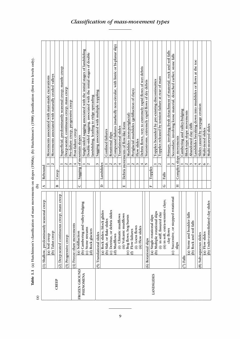
Landslide features (Figure 1.3)
(1) Crown: the practically undisplaced materialstill in place and adjacent to the highestparts of the main scarp (2).
(2) Main scarp: a steep surface on the undis-turbed ground at the upper edge of thelandslide, caused by movement of thedisplaced material (13) away from theundisturbed ground. It is the visible part ofthe surface of rupture (10).
(3) Top: the highest point of contact betweenthe displaced material (13) and the mainscarp (2).
(4) Head: the upper parts of the landslidealong the contact between the displacedmaterial (13) and the main scarp (2).
(5) Minor scarp: a steep surface on thedisplaced material (13) of the landslideproduced by differential movements withinthe displaced material (13).
(6) Main body: the part of the displacedmaterial (13) of the landslide that overliesthe surface of rupture (10) between themain scarp (2) and the toe of the surface ofrupture (11).
(7) Foot: the portion of the landslide that hasmoved beyond the toe of the surface ofrupture (11) and overlies the originalground surface (20).
(8) Tip: the point on the toe (9) farthest fromthe top (3) of the landslide.
(9) Toe: the lower, usually curved margin ofthe displaced material (13) of a landslide;it is the most distant margin of the land-slide from the main scarp (2).
(10) Surface of rupture: the surface thatforms (or which has formed) the lowerboundary of the displaced material (13)below the original ground surface (20).
(11) Toe of the surface of rupture: the inter-section (usually buried) between the lowerpart of the surface of rupture (10) and theoriginal ground surface (20).
(12) Surface of separation: the part of theoriginal ground surface (20) overlain bythe foot (7) of the landslide.
(13) Displaced material: material displacedfrom its original position on the slope bymovement in the landslide. It forms thedepleted mass (17) and the accumulation(18).
(14) Zone of depletion: the area of the land-slide within which the displaced material(13) lies below the original ground surface(20).
(15) Zone of accumulation: the area of the landslide within which the displacedmaterial (13) lies above the originalground surface (20).
(16) Depletion: the volume bounded by themain scarp (2), the depleted mass (17),and the original ground surface (20).
(17) Depleted mass: the volume of thedisplaced material (13) which overlies thesurface of rupture (10) but underlies theoriginal ground surface (20).
Figure 1.3 Terminology of landslides used in TheMultilingual Landslide Glossary; profile and planviews. See text for explanation of numbers. AfterWP/WLI (1993).
Classification of mass-movement types
11
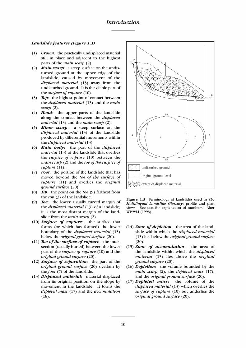
(18) Accumulation: the volume of thedisplaced material (13) which lies abovethe original ground surface (20).
(19) Flank: the undisplaced material adjacentto the sides of the surface of rupture (10).Compass directions are preferable indescribing the flanks, but if left and rightare used, they refer to the flanks as viewedfrom the crown (1).
(20) Original ground surface: the surface ofthe slope that existed before the landslidetook place.
Landslide dimensions (Figure 1.4)
(1) The width of the displaced mass, Wd, isthe maximum breadth of the displacedmass perpendicular to the length of thedisplaced mass, Ld (4).
(2) The width of the rupture surface, Wr, isthe maximum width between the flanks ofthe landslide, perpendicular to the lengthof the rupture surface, Lr (5).
(3) The total length, L, is the minimum fromthe tip of the landslide to the crown.
(4) The length of the displaced mass, Ld, isthe minimum distance from the tip to thetop.
(5) The length of the rupture surface, Lr, isthe minimum distance from the toe of thesurface of rupture to the crown.
(6) The depth of the displaced mass, Dd, isthe maximum depth of the displaced mass,measured perpendicular to the plane con-taining Wd (1) and Ld (4).
(7) The depth of the rupture surface, Dr, is the maximum depth of the rupturesurface below the original ground surfacemeasured perpendicular to the planecontaining Wr (2) and Lr (5).
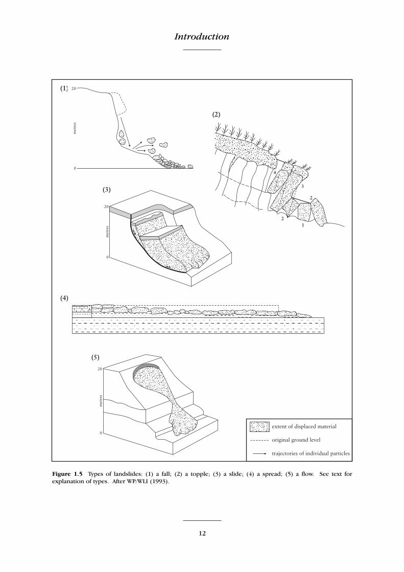
Types of landslides (Figure 1.5)
(1) A fall starts with detachment of soil or rockfrom a steep slope along a surface on whichlittle or no shear displacement takes place.The material then descends largely throughthe air by falling, saltation or rolling.
(2) A topple is the forward rotation, out of theslope, of a mass of soil or rock about apoint or axis below the centre of gravity ofthe displaced mass.
(3) A slide is the downslope movement of asoil or rock mass occurring dominantly onsurfaces of rupture or relatively thin zonesof intense shear strain.
(4) A spread is an extension of a cohesive soilor rock mass combined with a general sub-sidence of the fractured mass of cohesivematerial into softer underlying material.The rupture surface is not a surface ofintense shear. Spreads may result from theliquefaction or flow (and extrusion) of thesofter material.
(5) A flow is a spatially continuous movementin which surfaces of shear are short-lived,closely spaced and usually preserved. Thedistribution of velocities in the displacingmass resembles that in a viscous fluid.
Figure 1.4 Landslide dimensions recommended inThe Multilingual Landslide Glossary. See text forexplanation of numbers. Based on WP/WLI (1993)and Cruden et al. (1994).
Introduction
12
Figure 1.5 Types of landslides: (1) a fall; (2) a topple; (3) a slide; (4) a spread; (5) a flow. See text forexplanation of types. After WP/WLI (1993).
Classification of mass-movement types
13
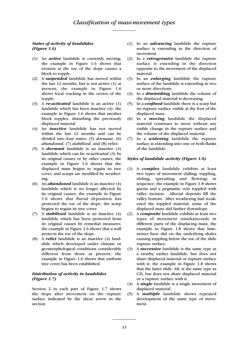
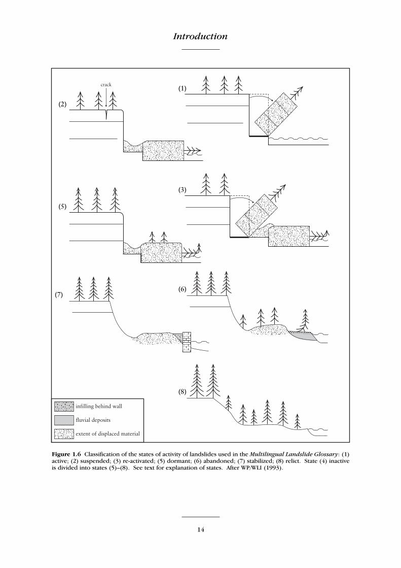
States of activity of landslides (Figure 1.6)
(1) An active landslide is currently moving;the example in Figure 1.6 shows thaterosion at the toe of the slope causes ablock to topple.
(2) A suspended landslide has moved withinthe last 12 months, but is not active (1) atpresent; the example in Figure 1.6 shows local cracking in the crown of thetopple.
(3) A re-activated landslide is an active (1)landslide which has been inactive (4); theexample in Figure 1.6 shows that anotherblock topples, disturbing the previouslydisplaced material.
(4) An inactive landslide has not movedwithin the last 12 months and can bedivided into four states: (5) dormant, (6)abandoned, (7) stabilized, and (8) relict.
(5) A dormant landslide is an inactive (4)landslide which can be re-activated (3) byits original causes or by other causes; theexample in Figure 1.6 shows that thedisplaced mass begins to regain its treecover, and scarps are modified by weather-ing.
(6) An abandoned landslide is an inactive (4)landslide which is no longer affected by its original causes; the example in Figure1.6 shows that fluvial deposition hasprotected the toe of the slope; the scarpbegins to regain its tree cover.
(7) A stabilized landslide is an inactive (4)landslide which has been protected fromits original causes by remedial measures;the example in Figure 1.6 shows that a wallprotects the toe of the slope.
(8) A relict landslide is an inactive (4) land-slide which developed under climatic orgeomorphological conditions considerablydifferent from those at present; theexample in Figure 1.6 shows that uniformtree cover has been established.
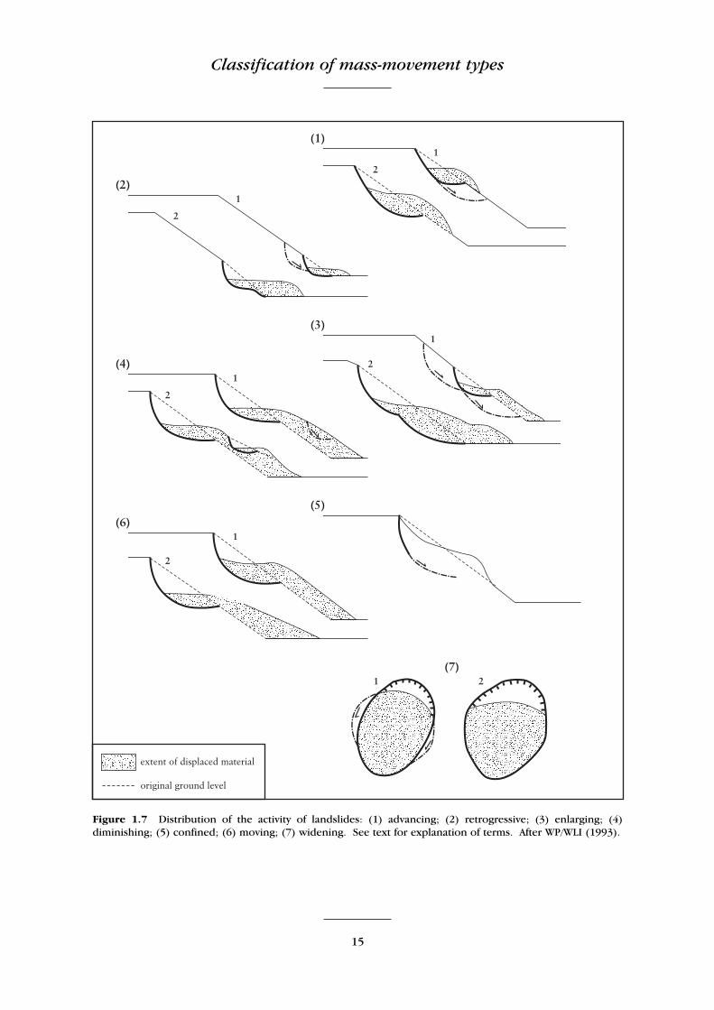
Distribution of activity in landslides(Figure 1.7)
Section 2 in each part of Figure 1.7 shows the slope after movement on the rupture surface indicated by the shear arrow in thesection.
(1) In an advancing landslide the rupturesurface is extending in the direction ofmovement.
(2) In a retrogressive landslide the rupturesurface is extending in the directionopposite to the movement of the displacedmaterial.
(3) In an enlarging landslide the rupturesurface of the landslide is extending in twoor more directions.
(4) In a diminishing landslide the volume ofthe displaced material is decreasing.
(5) In a confined landslide there is a scarp butno rupture surface visible at the foot of thedisplaced mass.
(6) In a moving landslide the displacedmaterial continues to move without anyvisible change in the rupture surface andthe volume of the displaced material.
(7) In a widening landslide the rupturesurface is extending into one or both flanksof the landslide.
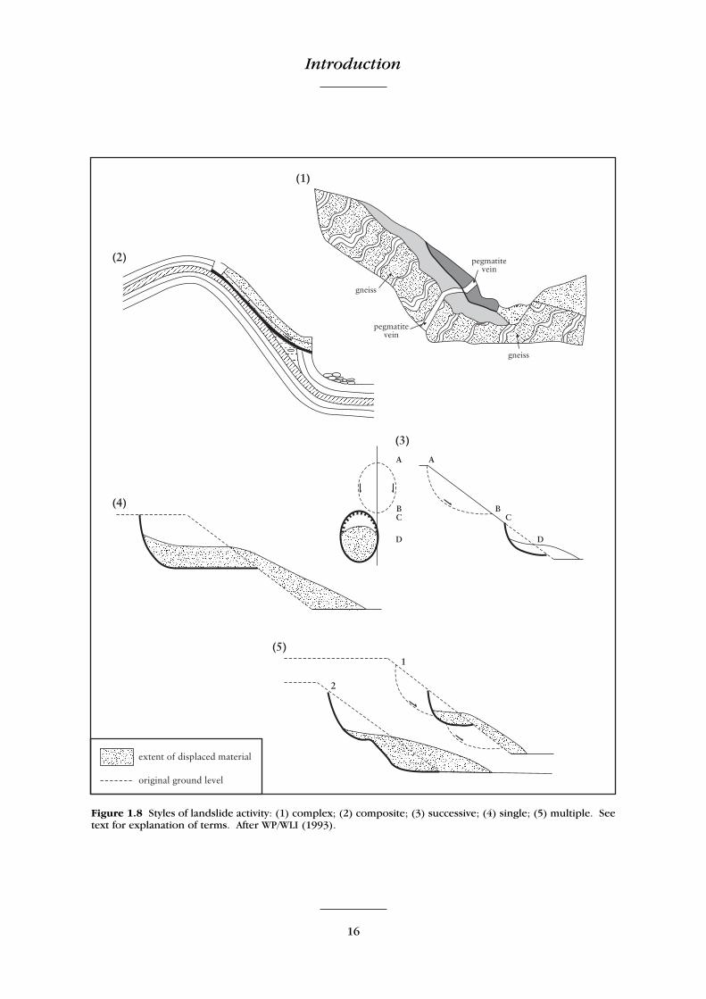
Styles of landslide activity (Figure 1.8)
(1) A complex landslide exhibits at least two types of movement (falling, toppling,sliding, spreading and flowing) insequence; the example in Figure 1.8 showsgneiss and a pegmatite vein toppled withvalley incision. Alluvial deposits fill thevalley bottom. After weathering had weak-ened the toppled material, some of thedisplaced mass slid farther downslope.
(2) A composite landslide exhibits at least twotypes of movement simultaneously indifferent parts of the displacing mass; theexample in Figure 1.8 shows that lime-stones have slid on the underlying shalescausing toppling below the toe of the sliderupture surface.
(3) A successive landslide is the same type asa nearby, earlier landslide, but does notshare displaced material or rupture surfacewith it; the example in Figure 1.8 showsthat the latter slide, AB, is the same type asCD, but does not share displaced materialor a rupture surface with it.
(4) A single landslide is a single movement ofdisplaced material.
(5) A multiple landslide shows repeateddevelopment of the same type of move-ment.
Introduction
14
Figure 1.6 Classification of the states of activity of landslides used in the Multilingual Landslide Glossary: (1)active; (2) suspended; (3) re-activated; (5) dormant; (6) abandoned; (7) stabilized; (8) relict. State (4) inactiveis divided into states (5)–(8). See text for explanation of states. After WP/WLI (1993).
Classification of mass-movement types
15
Figure 1.7 Distribution of the activity of landslides: (1) advancing; (2) retrogressive; (3) enlarging; (4)diminishing; (5) confined; (6) moving; (7) widening. See text for explanation of terms. After WP/WLI (1993).
Introduction
16
Figure 1.8 Styles of landslide activity: (1) complex; (2) composite; (3) successive; (4) single; (5) multiple. Seetext for explanation of terms. After WP/WLI (1993).
GCR site selection
17
GCR SITE SELECTION
Methodology
The rationale, methodology and history of theselection of sites for inclusion within theGeological Conservation Review programme hasbeen discussed in detail by Wimbledon et al.(1995) and in the introductory GCR volume(Ellis et al., 1996). The main factors consideredduring the selection process can be summarizedas:
(a) importance to the international Earthscientist community;
(b) presence of exceptional (classic, rare oratypical) geological/geomorphological fea-tures; and
(c) national importance for features that arerepresentative of geological events orprocesses that are fundamental to under-standing the geological/geomorphologicalhistory of Great Britain.
There are also the principles in GCR siteselection that a chosen site should be the bestavailable example of its kind, and that thereshould be a minimum of duplication of featuresbetween GCR sites.
To adapt these criteria specifically to massmovements has been particularly difficult, com-pared to geological (rather than geomorpholog-ical) selection categories.
Given Hutchinson’s (1968a) classification,one particular ‘type’ of mass movement might be represented by several sites to show thedifferent circumstances in which that ‘type’typically occurs. However, during original GCRsite selection it was not envisaged that, forexample, the ‘type’ called ‘rotational slips’would be represented in the ultimate GCRregister by an example in strata from each of thegeological periods, or in each region of thecountry, in which that type is found. Using theGCR ethos (Wimbledon et al., 1995; Ellis et al.,1996), the method of GCR site selection followedfor mass movements was that set out below.
1. A first-tranche list of 23 candidate GCR siteswas assembled, following literature surveyand initial research. This list was circulatedto relevant members of the geological,geomorphological and civil engineering
communities, with the suggestion that theymight delete some sites from the list, andrecommend other sites not on the list.
2. The result was that 116 candidate sites weresuggested for selection for the GCR by theconsultees (Table 1.2) – a five-fold increasein the originally circulated list. A statisticalsummary was produced, which waspublished in February 1982 in EarthScience Conservation (Anon. [Cooper] inBlack, 1982). The text of part of this articleis reproduced here:
‘…Of these [sites suggested for considera-tion], 65% are located in England (13%South-East, 22% Midlands, 20% North), 24%are located in Scotland, and 11% in Wales.One third have coastal locations, and 14%are on offshore islands. Just over a quarterof the sites suggested are in Carboniferousrocks, with the Namurian of the central andsouthern Pennines prominent. As might beexpected, the scarp-and-vale topography ofthe Jurassic is also a major location ofrecommended features (23%). Other impor-tant locations are the Precambrian (14%)and the Cretaceous (12%). Sites in theDevonian and Quaternary each make up6% of the total, while Cambrian, Triassicand Quaternary sites each provide 3%.Permian, Silurian and Ordovician siteseach provide less than 2% of the total.
The responses to the postal surveyexposed several general problems associatedwith site selection. Firstly, there is theproblem of the transience of most medium-and small-scale mass movement phenomena.Features which yield valuable informationand are educationally instructive immedi-ately after the mass movement has takenplace, may after a few years become totallyobscured by the smaller-scale processes thattend to even-out irregularities on slopes. Inother words, the value of such sites oftenresides in their freshness. There would belittle point in selecting for conservationsites which are unlikely to persist, since,unlike quarry sections, mass movementsites can seldom be ‘cleaned up’ withoutdestroying those features in which theiracademic interest resides. Secondly, thewell-known mass movement classificationsof Hutchinson and of Varnes include types

Introduction
18
So
uth
ern
En
glan
d
En
glis
h M
idla
nd
s N
ort
her
n E
ngl
and
W
ales
Sco
tlan
d
Axm
inst
er
Alp
ort
Cas
tles
As
krig
g Ab
erfa
n–C
ilfyn
ydd
An
Tea
llach
Ax
mo
uth
–Lym
e R
egis
B
red
on
Hill
B
ilsd
ale
Bla
ck M
ou
nta
ins
Arra
n n
ort
h c
oas
t B
ath
Un
iver
sity
B
rett
on
Clo
ugh
B
ird
sall
Blo
ren
ge
Arro
char
B
each
y H
ead
C
har
lesw
ort
h
Bu
ckla
nd
’s W
ind
ypit
B
od
afo
n M
ou
nta
in
Bei
nn
a’G
hlò
B
lack
Ven
C
row
den
C
anya
rds
Hill
s C
efn
-y-G
ader
B
ein
n A
lligi
n
Bla
ckn
or
Clif
fs
Dee
r H
ole
s C
astl
e E
den
Den
e C
raig
Cer
ig G
leis
iad
B
en A
tto
w (
Bei
nn
Fh
ada)
B
righ
ton
–Sal
tdea
n
Go
lden
Val
ley,
Ch
alfo
rd
Cau
tley
Sp
ou
t C
wm
ystw
yth
B
en L
awer
s C
hal
e B
ay c
liffs
G
rin
des
grai
n T
or
Dee
, Wir
ral
Llan
golle
n s
cree
s B
en T
ian
avai
g C
har
mo
uth
fore
sho
re
Hey
den
Bro
ok
Farn
dal
e Ll
yn-y
-Fan
Fâc
h B
en W
yvis
C
love
lly
Ho
b’s
Ho
use
Fr
emin
gto
n E
dge
N
ant
Gar
eg-I
wyd
B
raer
iach
Fo
lkes
ton
e W
arre
n
Jack
field
G
ord
ale
scre
es
Pon
terw
yd
Cas
tle
Ew
en
Go
lden
Cap
Lo
cker
bro
ok
Hei
ghts
H
ilbec
k Fe
ll T
al-y
-Lly
n v
alle
y C
no
c R
oll
Had
leig
h
Lon
gden
dal
e H
old
ern
ess
coas
t T
aren
-y-G
igfr
an
Co
ire
Gab
hai
l H
ern
e B
ay
Lud
’s C
hu
rch
K
ettl
enes
s, S
tait
hes
Ys
gyry
d F
awr
Cu
illin
scr
ees
Hig
h H
alst
ow
M
am T
or
Lake
Dis
tric
t sc
rees
Dru
mo
chte
r Pa
ss
Ho
g’s
Bac
k cl
iffs
No
rfo
lk C
oas
t M
alh
am
E
igg
Ho
oke
n C
liff,
Bee
r N
ort
han
ts ir
on
sto
ne
field
M
arsk
e
Gle
ann
an
Du
bh-L
och
ain
H
yth
e–Ly
mp
ne–
Ald
ingt
on
Pe
ter’
s R
ock
Pe
ak S
car
G
len
Pea
n
Ken
t an
d S
uss
ex C
hal
k cl
iffs
Post
lip W
arre
n
Ro
sed
ale
G
len
Tilt
K
eyn
sham
rai
lway
cu
ttin
g R
ock
ingh
am
Ro
wle
e Pa
stu
re
G
ribu
n, M
ull
Mai
dst
on
e ca
mbe
rin
g St
ow
-on
-th
e-W
old
R
un
swic
k B
ay
Ju
ra
Oak
en W
oo
d, M
edw
ay
Th
e W
on
der
Sc
arbo
rou
gh
La
irig
Gh
ru
Osm
ingt
on
W
este
nd
Val
ley
Spee
ton
Bay
Loch
Tea
chu
is
Seve
no
aks
byp
ass
Wyt
ham
Hill
T
eesd
ale
Lo
chn
agar
Sp
ot
Lan
e, M
aid
sto
ne
W
aker
ley
Q
uir
ain
g St
on
ebar
row
Wh
ites
ton
e C
liff
H
alla
ig, R
aasa
y V
entn
or
Un
der
cliff
Ru
dh
a G
orb
hai
g W
ard
en P
oin
t
St K
ilda
Win
terf
ord
Hea
th
St
orr
St
reap
T
into
Hill
s
Tab
le 1
.2T
he
can
did
ate
mas
s-m
ove
men
t G
CR
sit
es s
ugg
este
d b
y th
e p
anel
of
exp
erts
co
nsu
lted
in
th
e 19
80s.
GCR site selection
19
which are either of little importance orabsent altogether in Great Britain. Somecorrespondents expressed the view thatcoverage should include as wide a range ofexamples of mass movement types aspossible, while others suggested that onlysites with a pronounced morphologicalexpression, either on the surface or insection, should be considered. A thirdproblem is that many continuouslyoperating, small-scale processes, which areof great importance in Great Britain, do notgive rise to recognizable features either onthe surface or in section. For this reasonthey are not readily conservable. However,such processes, for example soil creep, areso widespread and commonplace that theyare deemed not to require conservation at afew, specified, ‘representative’ sites. Apragmatic solution has been adopted,whereby, as far as possible, Great Britain’s‘best’ example of each mass movement typeis only to be selected if that example is alsoa ‘good’ one when viewed from a globalperspective.
Of the individual sites recommended inthe responses to the postal survey, thecomplex of rotational slips on the southcoast between Axmouth and Lyme Regis wasthe most often mentioned, closely followedby the slumps in Quaternary deposits on thenorth Norfolk coast around Cromer andTrimingham. Next most frequently suggestedwas Warden Point on the coast of the Isle ofSheppey, followed jointly by FolkestoneWarren in Kent, the solifluction lobes on theLower Greensand escarpment nearSevenoaks, the Undercliff on the south coastof the Isle of Wight, the slips at Chale Bay onthe Isle of Wight, and the massive features atQuiraing and The Storr, in the Trotternishpeninsula of the Isle of Skye. Other much-mentioned sites included High Halstow inKent, the area around Bath, screes in theLake District and near Llangollen, Mam Torin the Peak District, and the abandonedcliff at Hadleigh Castle in Essex. Evenbetween these most mentioned sites, thereare obvious overlaps of mechanism, of sur-face form, and of cross-sectional features,so that the inclusion of all of them in theReview would involve unwarranted dupli-cation. Conversely, several sites havealready been assessed as suitable for inclu-
sion, even though each was only suggestedby a single correspondent.
At the close of the 1981 field season, 62%of the recommended sites had been eitherexamined in the field, or excluded from theexercise without a visit. The latter coursehas been taken either through prior personalknowledge of the site in question, orbecause a reading of the literature showsthe site to be an inferior duplicate. Manysites have been examined in aerial view atthe Cambridge University Collection of AirPhotographs. This has proved a mostvaluable aid to site selection or elimina-tion. It is anticipated that between twentyand thirty sites will eventually be selectedfor inclusion in the Review; the final choiceawaits completion of the programme offield visits.’
3. After sifting the original and emended lists,the remaining sites were all visited in thefield during 1981 and 1982 by the presentauthor (RGC). Photographs were takenalong with some measurements, facilitatingdirect comparison of what might be termed‘competitive’ candidate sites (the GCRbeing a minimalist scheme, see Ellis et al.,1996). The aim at this stage was to ensurethat a complete network of sites was estab-lished to represent the variety of mass-movement types and forms found in GreatBritain. After consultation and revision, alist of 28 sites was finally produced; thislist, with short descriptions, has been pub-lished in Jones and Lee (1994, pp. 242–7).This is the list (Table 1.3) that was finallyadopted, and is described in the presentbook, with the exception of the site at SpotLane Quarry near Maidstone in Kent,described by Worssam (1963), which wasincluded as an example of strata exhibitingtwo superficial structures: cambering andgulling. However, between 1980 when thesite was visited, and a return visit in 1996, ahousing estate had been extended onto thearea concerned. A small exposure has beenpreserved there on account of the fossilfauna of a gull filling (selected for theQuaternary of South-East England GCRBlock), but otherwise this remnant expo-sure now shows camber and gull featuresno better than many other sites across thecountry.
20
GCR Editor’s note:
A review of the Scottish Highland mass move-ments carried out after Roger Cooper’s deathshowed that there were eight sites, which, as aresult of recent investigations by ColinBallantyne and David Jarman, met GCRstandards. The new sites (described in Chapter2) are listed in Table 1.4. Had this informationbeen available at the time of the original scopingexercise, when none of these sites were suggested,
there is little doubt that they would have beenincluded. The review also showed that applyingthe ‘minimalist’ principle, one site, Glen Pean,would not now have been included in the GCR.Revised site information also became availablefor several of the already selected Scottish sites(Coire Gabhail – Chapter 4; and the TrotternishEscarpment (Quiraing and The Storr) – Chapter6). Tables 1.5 and 1.6 have been revised torecognize these changes.
Site classification
The style and type categories from The Multi-lingual Landslide Glossary, with the codes fromHutchinson’s classifications of 1968a and 1988,are shown along-side brief descriptions for eachof the mass-movement sites selected for the GCR,in Table 1.5. However, the GCR deals with sites(areas of land with a defined boundary), and theclassifications deal with the types of movementinvolved in a displaced mass, or mass undergoingdisplacement. Thus, Warden Point, for example,is recorded as composite in style, involving bothsliding and toppling. This could give the mis-leading impression that at Warden Point mass-movement events characteristically involve bothtoppling and sliding together. In fact, WardenPoint shows the results of several mass-movementevents, side by side along the coast. Of these,most are slides, but one shows toppling.
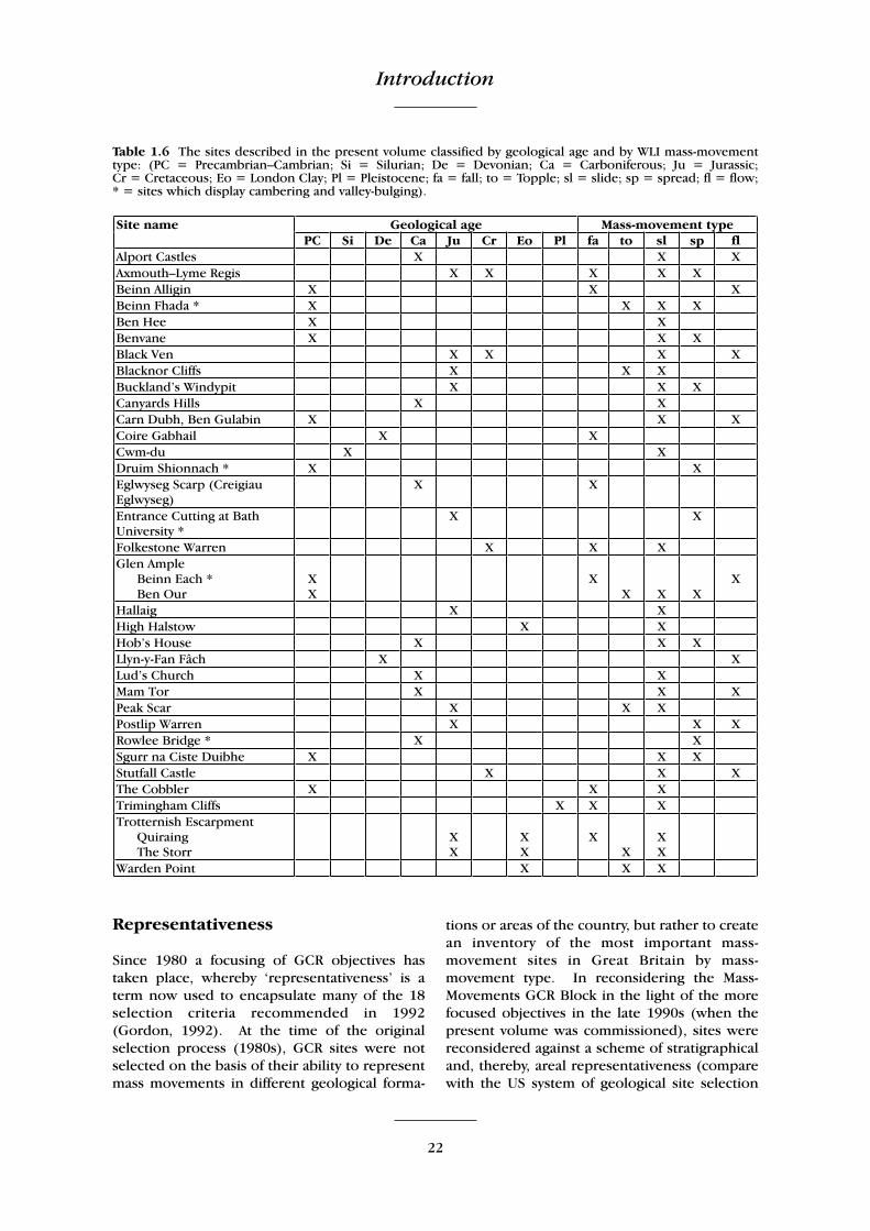
Table 1.6 shows the mass-movement GCR sitesdescribed in the present volume, classified intwo ways. First, by the stratigraphical order ofthe major geological systems in which the mass-movement phenomena occur in Great Britain.The second classification shows the broad move-ment mechanisms by which material movesdownslope. According to this classification lessthan half of the sites exhibit more than one typeof mass movement, but a few exhibit more thantwo types. There is some correlation with theareal extent of a site and the number of typespresent, but this is not always the case. Forexample, the Axmouth–Lyme Regis GCR siteruns along about 10 km of coastline, and exhibitssix of Hutchinson’s (1968a) types, while Quiraing,part of the Trotternish Escarpment GCR site,also a very large site, exhibits just one type. Mostsites of small areal extent, however, exhibit asingle type of mass movement. Rotational slips(groups 6a and 6bi) are the most common; thecharacter of this type is discussed in furtherdetail below.
Alport Castles, DerbyshireAxmouth–Lyme Regis, Devon–Dorset
Beinn Fhada, HighlandBlack Ven, Dorset
Blacknor Cliffs, DorsetBuckland’s Windypit, North Yorkshire
Canyards Hills, SheffieldCoire Gabhail, Highland
Eglwyseg Scarp (Creigiau Eglwyseg), ClwydEntrance Cutting at Bath University, Avon
Cwm-du, CeredigionFolkestone Warren, Kent
Glen Pean, Highland*Hallaig, Isle of Raasay, Highland
High Halstow, KentHob’s House, Derbyshire
Llyn-y-Fan Fâch, CarmarthenshireLud’s Church, North Staffordshire
Mam Tor, DerbyshirePeak Scar, North Yorkshire
Postlip Warren, GloucestershireRowlee Bridge, DerbyshireSpot Lane Quarry, Kent*
Stutfall Castle, Kent Trimingham Cliffs, Norfolk
Trotternish Escarpment, Isle of Skye, Highland (The Storr and Quiraing)
Warden Point, Kent
Table 1.3 The final list of selected mass-movementsites as drawn up in the early 1980s.
Beinn Alligin, HighlandBen Hee, Highland
Benvane (Beinn Bhàn), StirlingCarn Dubh, Ben Gulabin, Perthshire
The Cobbler (Beinn Artair), Argyll and ButeDruim Shionnach, Highland
Glen Ample, StirlingSgurr na Ciste Duibhe, Highland
Table 1.4 The supplementary sites added to the GCRfollowing recent research in Scotland.
Introduction
* Glen Pean and Spot Lane Quarry have now beendeleted from the Mass-Movements GCR ‘Block’ (selec-tion category) – see text.

GCR site selection
21
Sit
e A
uth
ors
’ cl
assi
fica
tio
ns
Sty
le
Typ
e H
utc
hin
son
cat
ego
ries
1968a
1988
Alp
ort
Cas
tles
M
ass
rock
cre
ep, r
etro
gres
sive
ro
tati
on
al, t
ran
slat
ion
al
Co
mp
osi
te
Slid
e, fl
ow
2,
5a,
6bi
B
2, D
2, D
4 Ax
mo
uth
–Lym
e R
egis
T
ran
slat
ion
al, r
ota
tio
nal
, su
bsid
ence
C
om
ple
x Sl
ide,
sp
read
5a
, 6bi
, 6a,
6c,
7a
, 7b
D2,
D3,
D4
Bei
nn
Fh
ada
(Ben
Att
ow
) La
rge-
scal
e sl
op
e d
efo
rmat
ion
, lo
cal s
lides
, po
ssib
le s
ags
or
forw
ard
to
pp
les
Co
mp
lex
Spre
ad
2, 5
a A2
, B2,
C1,
D
4, F
1 B
ein
n A
lligi
n
Larg
e ro
ckfa
ll w
ith
exc
ess
run
-ou
t Si
ngl
e Fa
ll, fl
ow
5f
ii, 7
b E
3, G
1 B
en H
ee
Arre
sted
tra
nsl
atio
nal
slid
e M
ult
iple
Sl
ide
5a
D4
Ben
van
e Sl
op
e d
efo
rmat
ion
an
d t
ran
slat
ion
al s
lide
Mu
ltip
le
Spre
ad, s
lide
2, 5
a B
2, D
4 B
lack
Ven
M
ud
slid
es
Co
mp
lex
Slid
e 5d
i E
1 B
lack
no
r C
liffs
B
lock
slid
e, s
lab
failu
re
Co
mp
lex
Slid
e, t
op
ple
5a
D
4 B
uck
lan
d’s
Win
dyp
it
Blo
ck s
lides
M
ult
iple
Sl
ide
5a
, 4b
D4
Can
yard
s H
ills
Tra
nsl
atio
nal
wit
h b
reak
up
into
rid
ges,
late
ral e
xten
sio
n
Mu
ltip
le
Slid
e 5a
D
4 C
arn
Du
bh, B
en G
ula
bin
Tra
nsl
atio
nal
slid
e to
flo
w
Sin
gle
Slid
e, fl
ow
5a
, 5fii
D
4, E
4 C
oir
e G
abh
ail
Ro
ckfa
lls, l
and
slid
e d
am, r
un
-up
op
po
site
M
ult
iple
Fa
ll 7b
G
1 C
wm
-du
Su
b-sn
ow
so
liflu
ctio
n s
hee
ts O
R ‘l
and
slid
es’
Mu
ltip
le
Slid
e 4a
, 5c
E2
Dru
im S
hio
nn
ach
In
-sit
u s
lop
e d
efo
rmat
ion
pro
gres
sin
g to
to
pp
ling
Co
mp
osi
te
Spre
ad
2 B
2, C
3 E
glw
yseg
Sca
rp (
Cre
igia
u E
glw
yseg
) Ac
tive
scr
ees
and
rel
ict
clit
ter
slo
pes
M
ult
iple
Fa
ll
7a, 7
b G
E
ntr
ance
Cu
ttin
g at
Bat
h U
niv
ersi
ty
Gu
lls, c
ambe
rs, d
ip-a
nd
-fau
lt s
tru
ctu
re
Co
mp
osi
te
Spre
ad
4b
H
Folk
esto
ne
War
ren
R
ock
falls
, cla
y ex
tru
sio
n, r
ota
tio
nal
C
om
ple
x Fa
ll, s
lide
6bi
D2,
G, H
H
alla
ig
Ro
tati
on
al s
lide,
po
ssib
ly s
eism
ical
ly t
rigg
ered
Si
ngl
e Sl
ide
6a
D2
Gle
n A
mp
le
B
ein
n E
ach
Ben
Ou
r C
om
pre
ssio
nal
slo
pe
def
orm
atio
n, l
oca
l ro
ckfa
ll E
xten
sio
nal
slo
pe
def
orm
atio
n, s
lides
, to
pp
les
Mu
ltip
le
Co
mp
lex
Spre
adSp
read
2, 7
b 2,
5a
A2, G
1 B
2, C
1, D
4,F1
H
igh
Hal
sto
w
Shal
low
su
cces
sive
ro
tati
on
al s
lips,
hill
was
h, s
oil
cree
p
Succ
essi
ve
Slid
e 1a
, 6bi
, 6c
B, D
2 H
ob’
s H
ou
se
Ro
tati
on
al s
lip
Sin
gle
Sl
ide
6a
D
2 Ll
yn-y
-Fan
Fâc
h D
ebri
s fl
ow
M
ult
iple
Fl
ow
5c
E
3 Lu
d’s
Ch
urc
h
Bed
-on
-bed
tra
nsl
atio
nal
slid
ing
wit
hin
a r
ota
tio
nal
mas
s Si
ngl
e Sl
ide
5a, 6
a D
2, D
4 M
am T
or
Slu
mp
-ear
thfl
ow
M
ult
iple
Sl
ide,
flo
w
6c, 5
c D
3, E
3, H
4 Pe
ak S
car
Blo
ck s
lide,
to
pp
les
Co
mp
lex
Slid
e, t
op
ple
5a
D
4, F
Po
stlip
War
ren
La
rge-
scal
e gr
avit
atio
nal
slip
s, ‘f
ou
nd
ers’
Su
cces
sive
Sp
read
5a
, 4b
H
Ro
wle
e B
rid
ge
Val
ley-
bulg
e C
om
ple
x Sp
read
4b
H
Sg
urr
na
Cis
te D
uib
he
Ext
ensi
on
al s
lop
e d
efo
rmat
ion
s an
d s
lides
C
om
ple
x Sp
read
, slid
e 2,
5a
B2,
D4
Stu
tfal
l Cas
tle
Soil
cree
p, e
arth
flo
w, t
ran
slat
ion
al
Co
mp
lex
Flo
w, s
lide
1a, 5
c, 6
b B
, D4,
E1
Th
e C
obb
ler
Sho
rt-t
rave
l arr
este
d t
ran
slat
ion
al s
lide;
als
o s
ub-
cata
clas
mic
Si
ngl
e Sl
ide,
fall
5a, 7
b D
4, E
3
Tri
min
gham
Clif
fs
Blo
ckfa
ll, s
eep
age
failu
re, m
ud
slid
es, r
ota
tion
al s
lip
Co
mp
osi
te
Fall,
slid
e 5d
i, 6a
D
2, E
1, G
, H
Tro
tter
nis
h E
scar
pm
ent
Q
uir
ain
g
Th
e St
orr
R
etro
gres
sive
tra
nsl
atio
nal
slid
e, r
ock
fall
Ret
rogr
essi
ve t
ran
slat
ion
al s
lide,
to
pp
les
Mu
ltip
le
Mu
ltip
le
Slid
e, fa
ll Sl
ide,
to
pp
le
5a, 7
b 5a
, 7b
D4,
G1
D4,
F2
War
den
Po
int
Ro
tati
on
al, t
op
ple
s C
om
po
site
Sl
ide,
to
pp
le
6b
D2,
F
Tab
le 1
.5T
he
mas
s-m
ove
men
t G
CR
sit
es c
des
crib
ed i
n t
he
pre
sen
t vo
lum
e; s
tyle
an
d t
ype
are
acco
rdin
g to
th
e W
orl
d L
and
slid
e In
ven
tory
(W
P/W
LI 1
993)
,cl
assi
ficat
ion
s ar
e ac
cord
ing
to H
utc
hin
son
(19
68a)
an
d (
1988
) –
des
crib
ed i
n T
able
1.1
a,b.
Introduction
22
Representativeness
Since 1980 a focusing of GCR objectives hastaken place, whereby ‘representativeness’ is aterm now used to encapsulate many of the 18selection criteria recommended in 1992(Gordon, 1992). At the time of the originalselection process (1980s), GCR sites were notselected on the basis of their ability to representmass movements in different geological forma-
tions or areas of the country, but rather to createan inventory of the most important mass-movement sites in Great Britain by mass-movement type. In reconsidering the Mass-Movements GCR Block in the light of the morefocused objectives in the late 1990s (when thepresent volume was commissioned), sites werereconsidered against a scheme of stratigraphicaland, thereby, areal representativeness (comparewith the US system of geological site selection
Geological age Mass-movement type Site name PC Si De Ca Ju Cr Eo Pl fa to sl sp fl
Alport Castles X X X Axmouth–Lyme Regis X X X X X Beinn Alligin X X X Beinn Fhada * X X X X Ben Hee X X Benvane X X X Black Ven X X X X Blacknor Cliffs X X X Buckland’s Windypit X X X Canyards Hills X X Carn Dubh, Ben Gulabin X X X Coire Gabhail X X Cwm-du X X Druim Shionnach * X X Eglwyseg Scarp (Creigiau Eglwyseg)
X X
Entrance Cutting at Bath University *
X X
Folkestone Warren X X X Glen Ample Beinn Each * Ben Our
XX
X
X X XX
Hallaig X X High Halstow X X Hob’s House X X X Llyn-y-Fan Fâch X X Lud’s Church X X Mam Tor X X X Peak Scar X X X Postlip Warren X X X Rowlee Bridge * X X Sgurr na Ciste Duibhe X X X Stutfall Castle X X X The Cobbler X X X Trimingham Cliffs X X X Trotternish Escarpment Quiraing The Storr
XX
XX
XX
XX
Warden Point X X X
Table 1.6 The sites described in the present volume classified by geological age and by WLI mass-movementtype: (PC = Precambrian–Cambrian; Si = Silurian; De = Devonian; Ca = Carboniferous; Ju = Jurassic; Cr = Cretaceous; Eo = London Clay; Pl = Pleistocene; fa = fall; to = Topple; sl = slide; sp = spread; fl = flow;* = sites which display cambering and valley-bulging).
GCR site selection
23
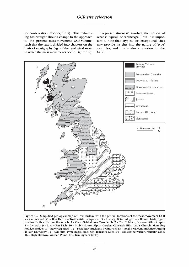
for conservation; Cooper, 1985). This re-focus-ing has brought about a change to the approachto the present mass-movement GCR volume,such that the text is divided into chapters on thebasis of stratigraphy (age of the geological stratain which the mass movements occur; Figure 1.9).
‘Representativeness’ involves the notion ofwhat is typical, or ‘archetypal’, but it is impor-tant to note that ‘atypical’ or ‘exceptional’ sitesmay provide insights into the nature of ‘type’examples, and this is also a criterion for theGCR.
Figure 1.9 Simplified geological map of Great Britain, with the general locations of the mass-movement GCRsites numbered: (1 – Ben Hee: 2 – Trotternish Escarpment: 3 – Hallaig; Beinn Alligin: 4 – Beinn Fhada; Sgurrna Ciste Duibhe; Druim Shionnach: 5 – Coire Gabhail: 6 – Carn Dubh: 7 – The Cobbler; Benvane; Glen Ample:8 – Cwm-du: 9 – Llyn-y-Fan Fâch: 10 – Hob’s House; Alport Castles; Canyards Hills; Lud’s Church; Mam Tor;Rowlee Bridge: 11 – Eglwyseg Scarp: 12 – Peak Scar; Buckland’s Windypit: 13 – Postlip Warren; Entrance Cuttingat Bath University: 14 – Axmouth–Lyme Regis; Black Ven; Blacknor Cliffs: 15 – Folkestone Warren; Stutfall Castle:16 – High Halstow: Warden Point: 17 – Trimingham Cliffs).
Introduction
24
Revision of the GCR in the future
Mass-movements studies, like any other science,are ever-developing, with new discoveries beingmade, and existing models being subject tocontinual testing and modification as new datacome to light. Increased or hitherto unrecog-nized significance may be seen in new sites.Therefore, it is possible that further sites worthyof conservation will be identified in future yearsfor the study of mass movements in Britain, asresearch continues. However, it must bestressed that the GCR is intended to be aminimalist scheme, with the selection for theGCR of only the best and most representativeexample of a geological feature, rather than theselection of a series of sites showing closelyanalogous features.
Legal protection of GCR sites
V.J. May and N.V. Ellis
The list of GCR sites has been used as a basis forestablishing Earth science Sites of SpecialScientific Interest (SSSIs), protected under theWildlife and Countryside Act 1981 (as amended)by the statutory nature conservation agencies(the Countryside Council for Wales, NaturalEngland and Scottish Natural Heritage).
The SSSI designation is the main protectionmeasure in the UK for sites of importance toconservation because of the wildlife theysupport, or because of the geological andgeomorphological features that are found there.About 8% of the total land area of Britain isdesignated as SSSIs. Well over half of the SSSIs,by area, are internationally important for aparticular conservation interest and areadditionally protected through internationaldesignations and agreements.
About one third of the SSSIs have a geological/geomorphological component that constitutesat least part of the ‘special interest’. Althoughsome SSSIs are designated solely because of theimportance to wildlife conservation, there aremany others that have both such features andgeological/geomorphological features of ‘specialinterest’. Furthermore, there are localities that,regardless of their importance to wildlifeconservation, are conserved as SSSIs solely onaccount of their importance to geological orgeomorphological studies.
Therefore, many SSSIs are composite, withsite boundaries drawn from a ‘mosaic’ of one ormore GCR sites and wildlife ‘special interest’areas; such sites may be heterogeneous incharacter, in that different constituent parts maybe important for different features.
Many of the SSSIs that are designated solelybecause of their Earth science features haveinteresting wildlife and habitat features, under-lining the inextricable links between habitat,biodiversity and the underlying geology andgeomorphology.
It is evident from some of the individual sitereports in this volume, describing sites in coastallocations, that the conservation interest of thegeomorphological features is likely to beaffected by shoreline management activities out-side of the site itself, especially where the GCRsites lie within large sediment-transport cells. Anumber of the sites have landslide toes whichextend below low-water mark of spring tides.However, since SSSI notification of GCR sitespresently extends to mean low-water mark inEngland and Wales and low-water mark of spring tides in Scotland, there is no statutoryprotection of these landslide toes below low-water mark, unless they are co-incidentally partof some other conservation designation (e.g.Special Protection Areas or Special Areas ofConservation – see below).
International measures
Presently, there is no formal internationalconservation convention or designation forgeological/geomorphological sites below thelevel of the ‘World Heritage Convention’ (the‘Convention concerning the Protection of theWorld Cultural and Natural Heritage’). WorldHeritage Sites are declared by the UnitedNations Educational, Scientific and CulturalOrganisation (UNESCO). The objective of theWorld Heritage Convention is the protection ofnatural and cultural sites of global significance.Many of the British World Heritage Sites are‘cultural’ in aspect, but the Giant’s Causeway inNorthern Ireland and the Dorset and East DevonCoast (‘the Jurassic Coast’) are inscribedbecause of their importance to the Earthsciences as part of the ‘natural heritage’ – theDorset and East Devon Coast World HeritageSite is of particular relevance here insofar as itwas the outstanding geology and coastal geo-
Organization of the mass-movements GCR volume
25
morphology (including sites described in thisvolume and other sites described in the CoastalGeomorphology of Great Britain GCR volume(May and Hansom, 2003) that include mass-movement phenomena).
In contrast to the Earth sciences, there aremany other formal international conventions –particularly at a European level – concerning theconservation of wildlife and habitat. Of course,many sites that are formally recognizedinternationally for their contribution to wildlifeconservation are underpinned by their geological/geomorphological character, but this fact is onlyimplicit in such designations. Nevertheless, someof the sites described in the present volume arenot only geomorphological SSSIs, but alsohabitat sites recognized as being internationallyimportant. These areas are thus afforded furtherprotection by international designations abovethe provisions of the SSSI system.
Special Areas of Conservation (SACs)Of special relevance to the present volume arethose coastal and mountain habitats that aredependent upon coastal or mountain geomor-phology and are conserved as Special Areas ofConservation (SACs). In 1992 the EuropeanCommunity adopted Council Directive92/43/EEC on the conservation of natural habi-tats and of wild fauna and flora, commonlyknown as the ‘Habitats Directive’. This is animportant piece of supranational legislation forwildlife conservation under which a Europeannetwork of sites is selected, designated and pro-tected. The aim is to help conserve the 169 habi-tat types and 623 species identified in Annexes Iand II of the Directive.
Special Protection Areas (SPAs)Special Protection Areas are strictly protectedsites classified in accordance with Article 4 of the EC Directive on the conservation of wild birds (79/409/EEC), also known as the ‘BirdsDirective’, which came into force in April 1979.They are classified for rare and vulnerable birds,listed in Annex I to the Birds Directive, and forregularly occurring migratory species.
Although SACs and SPAs are identified for theconservation importance of their biologicalfeatures, individually or collectively, many alsoinclude scientifically important geomorpho-logical features.
GCR site selection in conclusion
It is clear from the foregoing that many factorshave been involved in selecting and protectingthe sites described in this volume. Sites rarelyfall neatly into one category or another; normallythey have attributes and characteristics thatsatisfy a range of the GCR guidelines andpreferential weightings (Ellis et al., 1996). A fullappreciation of the reasons for the selection ofindividual sites cannot be gained from these fewparagraphs. The full justification and argumentsbehind the selection of particular sites are onlyexplained satisfactorily by the site accounts givenin the subsequent chapters of the present volume.
ORGANIZATION OF THE MASS-MOVEMENTS GCR VOLUME
The original plan for this volume was to divide itinto chapters on the basis of mass-movementtype. Thus, there would be a chapter onrotational slide sites, another on bedding-planecontrolled slide sites, and so on. It was quicklyrealized that this would fail to representadequately the network of GCR sites actuallyselected. In particular it separated some sites,which, when placed together, illustrated verywell the variety of mass movements found inparticular areas of the country, for example thesouthern Pennines. Since most of the sitesillustrate complex landslides involving severaltypes of failure, rather than single mechanisms,classification would be difficult.
However, a succession of chapters, some ofwhich were based on mass-movement type, whileothers were based on regional considerations,gave a disorganized impression. Accordingly thepresent stratigraphical arrangement was adopted.This is still less than ideal. While it works well inhighlighting the main mass-movement producingsystems in Great Britain: Carboniferous, Jurassicand Cretaceous strata (which together accountfor 75% of the landslides identified in the DoEsurvey; Jones and Lee, 1994), it is less successfulfor sites in other geological systems. Since all ofthe mass movements in Great Britain representedby the sites described in the present volume havetaken place in Quaternary times, the relevanceof the age of the rocks in which they have takenplace is indirect. More significant factorsinclude the attitude of bedding, the frequency of
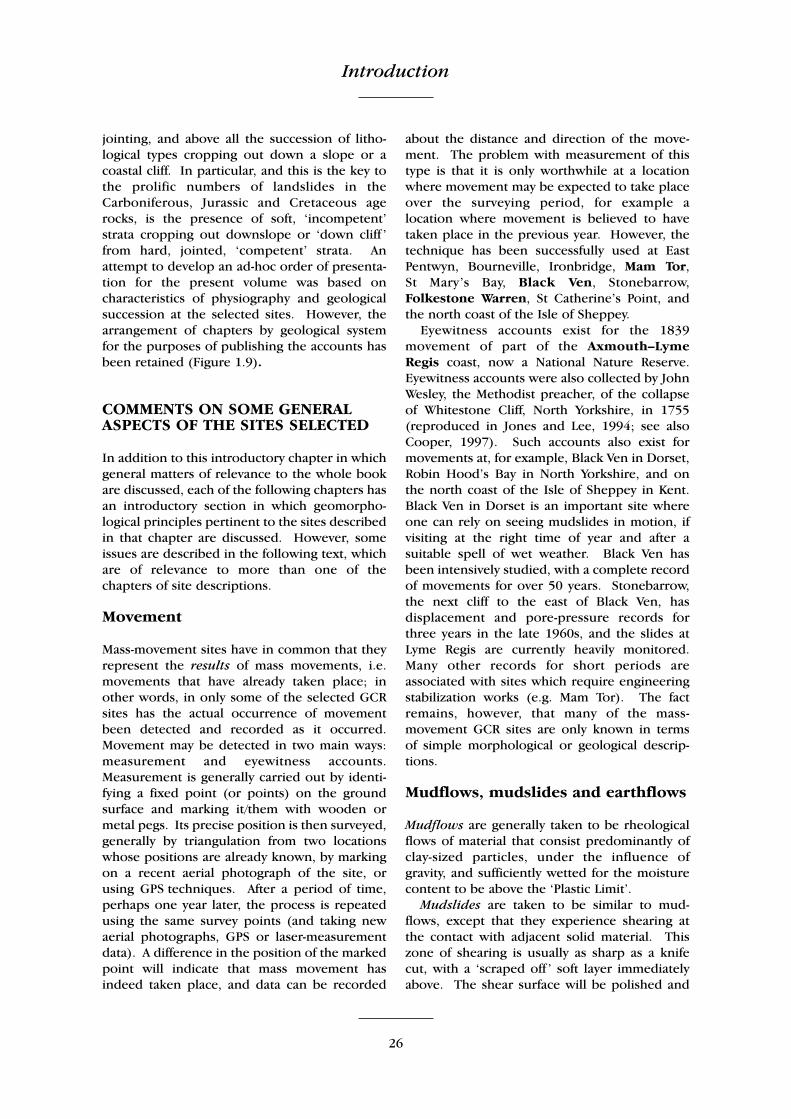
26
jointing, and above all the succession of litho-logical types cropping out down a slope or acoastal cliff. In particular, and this is the key tothe prolific numbers of landslides in theCarboniferous, Jurassic and Cretaceous agerocks, is the presence of soft, ‘incompetent’strata cropping out downslope or ‘down cliff ’from hard, jointed, ‘competent’ strata. Anattempt to develop an ad-hoc order of presenta-tion for the present volume was based oncharacteristics of physiography and geologicalsuccession at the selected sites. However, thearrangement of chapters by geological systemfor the purposes of publishing the accounts hasbeen retained (Figure 1.9).
COMMENTS ON SOME GENERALASPECTS OF THE SITES SELECTED
In addition to this introductory chapter in whichgeneral matters of relevance to the whole bookare discussed, each of the following chapters hasan introductory section in which geomorpho-logical principles pertinent to the sites describedin that chapter are discussed. However, someissues are described in the following text, whichare of relevance to more than one of thechapters of site descriptions.
Movement
Mass-movement sites have in common that theyrepresent the results of mass movements, i.e.movements that have already taken place; inother words, in only some of the selected GCRsites has the actual occurrence of movementbeen detected and recorded as it occurred.Movement may be detected in two main ways:measurement and eyewitness accounts.Measurement is generally carried out by identi-fying a fixed point (or points) on the groundsurface and marking it/them with wooden ormetal pegs. Its precise position is then surveyed,generally by triangulation from two locationswhose positions are already known, by markingon a recent aerial photograph of the site, orusing GPS techniques. After a period of time,perhaps one year later, the process is repeatedusing the same survey points (and taking newaerial photographs, GPS or laser-measurementdata). A difference in the position of the markedpoint will indicate that mass movement hasindeed taken place, and data can be recorded
about the distance and direction of the move-ment. The problem with measurement of thistype is that it is only worthwhile at a locationwhere movement may be expected to take placeover the surveying period, for example alocation where movement is believed to havetaken place in the previous year. However, thetechnique has been successfully used at EastPentwyn, Bourneville, Ironbridge, Mam Tor, St Mary’s Bay, Black Ven, Stonebarrow,Folkestone Warren, St Catherine’s Point, andthe north coast of the Isle of Sheppey.
Eyewitness accounts exist for the 1839movement of part of the Axmouth–Lyme Regis coast, now a National Nature Reserve.Eyewitness accounts were also collected by JohnWesley, the Methodist preacher, of the collapseof Whitestone Cliff, North Yorkshire, in 1755(reproduced in Jones and Lee, 1994; see alsoCooper, 1997). Such accounts also exist formovements at, for example, Black Ven in Dorset,Robin Hood’s Bay in North Yorkshire, and onthe north coast of the Isle of Sheppey in Kent.Black Ven in Dorset is an important site whereone can rely on seeing mudslides in motion, ifvisiting at the right time of year and after asuitable spell of wet weather. Black Ven hasbeen intensively studied, with a complete recordof movements for over 50 years. Stonebarrow,the next cliff to the east of Black Ven, hasdisplacement and pore-pressure records forthree years in the late 1960s, and the slides atLyme Regis are currently heavily monitored.Many other records for short periods areassociated with sites which require engineeringstabilization works (e.g. Mam Tor). The factremains, however, that many of the mass-movement GCR sites are only known in terms of simple morphological or geological descrip-tions.
Mudflows, mudslides and earthflows
Mudflows are generally taken to be rheologicalflows of material that consist predominantly ofclay-sized particles, under the influence ofgravity, and sufficiently wetted for the moisturecontent to be above the ‘Plastic Limit’.
Mudslides are taken to be similar to mud-flows, except that they experience shearing atthe contact with adjacent solid material. Thiszone of shearing is usually as sharp as a knifecut, with a ‘scraped off ’ soft layer immediatelyabove. The shear surface will be polished and
Introduction

Comments on some general aspects of the sites selected
27
striated. Deep-seated slides and extrusion layersmay have a thicker zone of displacement.Mudslides can form within mudslides as they dryout, but still they are bounded by separate, clearshears (Brunsden, 1984).
This distinction largely became acknowledgedwith the publication of an important paper byHutchinson and Bhandari (1971), in which itwas explicitly recognized that many of the massmovements previously described as mudflowsactually advance by sliding on discrete boundaryshear surfaces, and that such mass movementsare better termed ‘mudslides’, a term used byFleming (1978) and by Cailleux and Tricart(1950). It was demonstrated that very often thesurging forward of a ‘mudflow’ was caused notby flowage, but by undrained loading of itsrearward parts, the whole mass moving down-slope by sliding. However, the term ‘mudflow’is still valid for very fine-grained flows, but it isalso an old term for mudslides. Hutchinson’s1968a ‘climatic mudflows’ (see Table 1.1a above)are now mudslides (Brunsden, 1984).
In the World Landslide Inventory (WP/WLI1993) classification, the American usage ‘Earth-flow’ is preferred. Buma and van Asch state inLandslide Recognition (Dikau et al., 1996) that‘the American usage ‘earthflow’ is replaced inEuropean literature by ‘mudslide’’. However,‘earthflow’ is used by Skempton et al. (1989) indescribing part of the landslide at Mam Tor(see Chapter 5). Varnes (1978), the principalAmerican source on such matters, does notendorse this one-to-one correspondence interminology. Stating that earthflows range inwater content from above saturation toessentially dry, he places mudflows at the wetend of the scale, as ‘soupy end members of the family of predominantly fine-grained earthflows’. This neglects the importantobservation that the ‘stiffer’ forms slide ondiscrete surfaces.
Undrained loading
Hutchinson and Bhandari (1971) provided anexpanded account of a suggestion made byHutchinson (1970) which applies to manymudslides and also to a variety of other types ofmass movement. They observed that many‘mudflows’ were advancing downslope byshearing on slopes that were of considerablylower angle than the slope of limitingequilibrium for residual strength on the sliding
surface and groundwater co-incident with andflowing parallel to the slope surface. Forexample, with slopes at Bouldnor, Isle of Wightthat have residual strength of cr' = 0, ør' = 13.5°(where cr' is residual cohesion and ør' is angle of internal friction), it was shown using infinite slope analysis (Skempton andDelory, 1957) that the lowest slope angle atwhich sliding could occur is 6.1°. Measurementof these slopes showed that they stand at angles as low as 3.9° (Hutchinson and Bhandari,1971). They suggested that the sliding isbrought about by the virtually undrainedloading of the headward parts of the mudslidesby debris discharged from steeper slopes to the rear. This undrained loading develops aforward thrust in the rear part of the mudslide,where the basal slip-surface is inclined fairlysteeply downwards, giving rise to shearingmovements on very low angle slopes (Figure1.10), even at slopes of zero or negativeinclination for short distances (Hutchinson andBhandari, 1971).
Collapse of caprocks
There is a group of mass movements, generallycharacterized by a hard but possibly jointedcaprock, which does not have to be thin and canbe several tens of metres in thickness, overlyinga stratum or series of strata characterized by‘incompetence’, the inability to support theoverlying ‘competent’ caprock at locationswhere erosion has cut down to expose theincompetent strata. This can lead, according tolocal circumstances, to one or more of a varietyof recognized mass-movement types, in theterms of Hutchinson (1988) rebound associatedwith naturally eroded valleys, post-failure creep,and complex failures of types (1) cambering andvalley bulging, and (2) block-type slope move-ments.
This phenomenon has been more widelyaccepted in continental Europe and other partsof the world than in Great Britain (Brunsden,1996a). Possibly, British workers, who naturallyare those who have been most closely concernedwith British mass movements, have been toocircumspect. Why invoke a thick mobile stratumwhen a thin one will do? This shows confusionbetween theory and verification. In a highlyempirical subject like geology such theorizingmust give way to evidence that shows nature tobe more complex than expected.
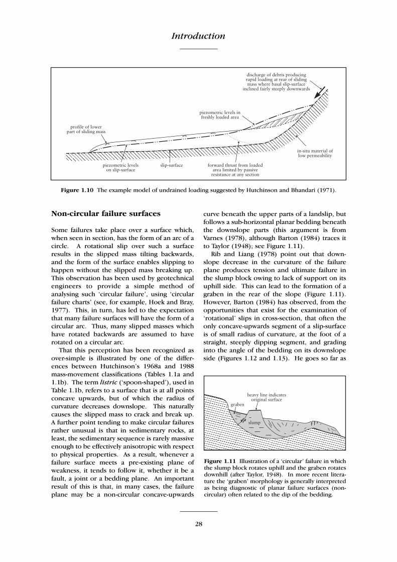
Introduction
28
Non-circular failure surfaces
Some failures take place over a surface which,when seen in section, has the form of an arc of acircle. A rotational slip over such a surfaceresults in the slipped mass tilting backwards,and the form of the surface enables slipping tohappen without the slipped mass breaking up.This observation has been used by geotechnicalengineers to provide a simple method ofanalysing such ‘circular failure’, using ‘circularfailure charts’ (see, for example, Hoek and Bray,1977). This, in turn, has led to the expectationthat many failure surfaces will have the form of acircular arc. Thus, many slipped masses whichhave rotated backwards are assumed to haverotated on a circular arc.
That this perception has been recognized asover-simple is illustrated by one of the differ-ences between Hutchinson’s 1968a and 1988mass-movement classifications (Tables 1.1a and1.1b). The term listric (‘spoon-shaped’), used inTable 1.1b, refers to a surface that is at all pointsconcave upwards, but of which the radius ofcurvature decreases downslope. This naturallycauses the slipped mass to crack and break up.A further point tending to make circular failuresrather unusual is that in sedimentary rocks, atleast, the sedimentary sequence is rarely massiveenough to be effectively anisotropic with respectto physical properties. As a result, whenever afailure surface meets a pre-existing plane ofweakness, it tends to follow it, whether it be afault, a joint or a bedding plane. An importantresult of this is that, in many cases, the failureplane may be a non-circular concave-upwards
curve beneath the upper parts of a landslip, butfollows a sub-horizontal planar bedding beneaththe downslope parts (this argument is fromVarnes (1978), although Barton (1984) traces itto Taylor (1948); see Figure 1.11).
Rib and Liang (1978) point out that down-slope decrease in the curvature of the failureplane produces tension and ultimate failure inthe slump block owing to lack of support on itsuphill side. This can lead to the formation of agraben in the rear of the slope (Figure 1.11).However, Barton (1984) has observed, from theopportunities that exist for the examination of‘rotational’ slips in cross-section, that often theonly concave-upwards segment of a slip-surfaceis of small radius of curvature, at the foot of astraight, steeply dipping segment, and gradinginto the angle of the bedding on its downslopeside (Figures 1.12 and 1.13). He goes so far as
Figure 1.11 Illustration of a ‘circular’ failure in whichthe slump block rotates uphill and the graben rotatesdownhill (after Taylor, 1948). In more recent litera-ture the ‘graben’ morphology is generally interpretedas being diagnostic of planar failure surfaces (non-circular) often related to the dip of the bedding.
Figure 1.10 The example model of undrained loading suggested by Hutchinson and Bhandari (1971).
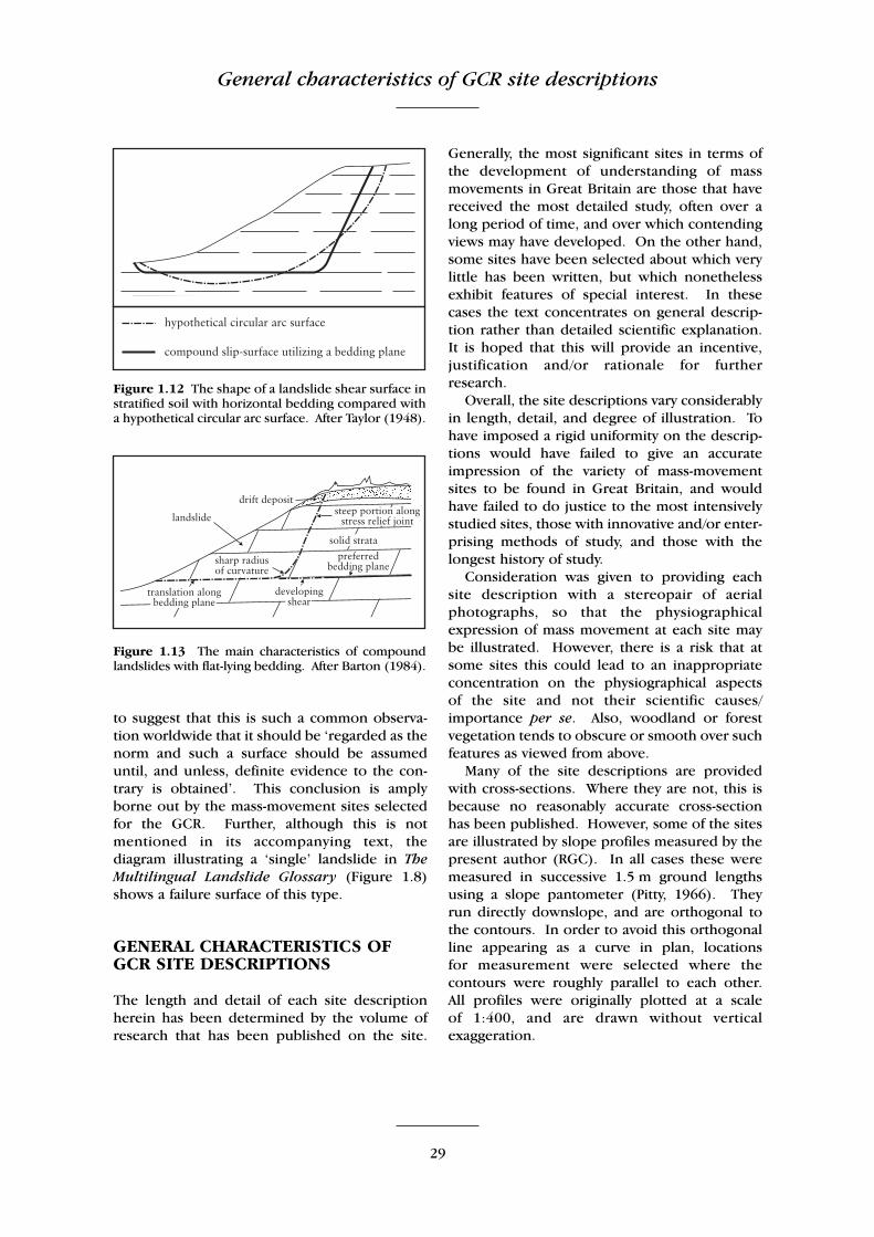
General characteristics of GCR site descriptions
29
to suggest that this is such a common observa-tion worldwide that it should be ‘regarded as thenorm and such a surface should be assumeduntil, and unless, definite evidence to the con-trary is obtained’. This conclusion is amplyborne out by the mass-movement sites selectedfor the GCR. Further, although this is notmentioned in its accompanying text, thediagram illustrating a ‘single’ landslide in TheMultilingual Landslide Glossary (Figure 1.8)shows a failure surface of this type.
GENERAL CHARACTERISTICS OFGCR SITE DESCRIPTIONS
The length and detail of each site descriptionherein has been determined by the volume ofresearch that has been published on the site.
Generally, the most significant sites in terms ofthe development of understanding of massmovements in Great Britain are those that havereceived the most detailed study, often over along period of time, and over which contendingviews may have developed. On the other hand,some sites have been selected about which verylittle has been written, but which nonethelessexhibit features of special interest. In thesecases the text concentrates on general descrip-tion rather than detailed scientific explanation.It is hoped that this will provide an incentive,justification and/or rationale for furtherresearch.
Overall, the site descriptions vary considerablyin length, detail, and degree of illustration. Tohave imposed a rigid uniformity on the descrip-tions would have failed to give an accurateimpression of the variety of mass-movementsites to be found in Great Britain, and wouldhave failed to do justice to the most intensivelystudied sites, those with innovative and/or enter-prising methods of study, and those with thelongest history of study.
Consideration was given to providing eachsite description with a stereopair of aerialphotographs, so that the physiographicalexpression of mass movement at each site maybe illustrated. However, there is a risk that atsome sites this could lead to an inappropriateconcentration on the physiographical aspectsof the site and not their scientific causes/importance per se. Also, woodland or forestvegetation tends to obscure or smooth over suchfeatures as viewed from above.
Many of the site descriptions are providedwith cross-sections. Where they are not, this isbecause no reasonably accurate cross-sectionhas been published. However, some of the sitesare illustrated by slope profiles measured by thepresent author (RGC). In all cases these weremeasured in successive 1.5 m ground lengthsusing a slope pantometer (Pitty, 1966). They run directly downslope, and are orthogonal tothe contours. In order to avoid this orthogonalline appearing as a curve in plan, locations for measurement were selected where thecontours were roughly parallel to each other. All profiles were originally plotted at a scale of 1:400, and are drawn without verticalexaggeration.
Figure 1.12 The shape of a landslide shear surface instratified soil with horizontal bedding compared witha hypothetical circular arc surface. After Taylor (1948).
Figure 1.13 The main characteristics of compoundlandslides with flat-lying bedding. After Barton (1984).