Embed Size (px)
Citation preview
RY ........
/_ MAR 1 b· 19Ba'"° 5 )MASHINGTON J
GEOLOGIC NEWSLETTER
Volume 16 Number 1 February 1988 I
I
Division of Geology and Earth Resources
1/
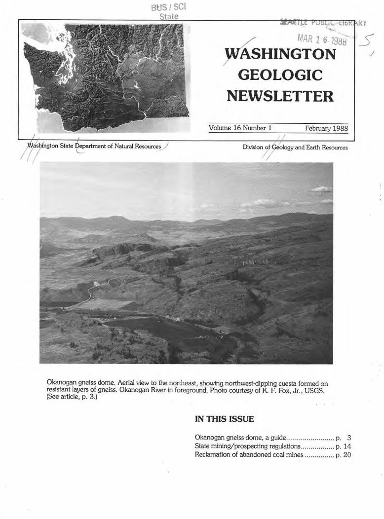
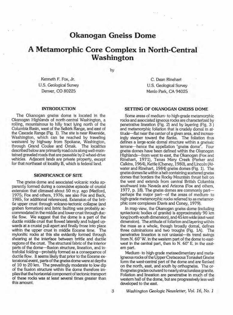
Okanogan gneiss dome. Aerial view to the northeast, showing northwest-dipping cuesta formed on resistant layers of gneiss. Okanogan River in foreground. Photo courtesy of K. F. Fox, Jr., USGS. (See article, p. 3.)
IN THIS ISSUE
Okanogan gneiss dome, a guide ................ .... .. .. p. 3 State mining/prospecting regulations ................. p. 14 Reclamation of abandoned coal mines ..... .......... p. 20
WASHINGTON
GEOLOGIC
NEWSLETTER
The Washington GeologJc Newsletter ls pubUshed quarterly by the Division of Geology and Earth Resources, Department of Natural Resources. The newsletter Is free upon request. The Division also publishes bulletins, Information circulars, reports of Investigations, and geologlc maps. A list of these publications will be sent upon request.
DEPARTMENT OF NATURAL RESOURCES
Brian J . Boyle Commissioner of Public Lands
Art Stearns Supervisor
DIVISION OF GEOLOGY AND EARTH RESOURCES
Raymond Lasmanis State Geologist
J. Eric Schuster Asst. State Geologist
Geologists (Olympia)
Geologists (Spokane)
Librarian
Research Technician
Editor
Cartographers
Bonnle B. Bunning Michael A. Korosec William S. Lingley, Jr. Robert L. (Josh) Logan William M. Phillips
Nancy L. Joseph
Weldon W. Rau Katherine M. Reed Henry W. Schasse
Gerald W. Thorsen Timothy J. Walsh
Keith L. Stoff.el
Connie J. Manson
Arnold Bowman
Katherine M. Reed
Nancy E. Herman Donald W. Hiller
Keith G. Ikerd
Word Processor Operator
Administrative Assistant
Clerical Staff
J . C. Armbruster
Susan P. Davis
Loretta M. Andrake Willa Bonaparte
Joy Fleenor
Regulatory Clerical Staff Barbara A. Preston
Main Office:
Field Office:
MAILING ADDRESSES
Department of Natural Resources Division of Geology and Earth Resources Mall Stop PY,12 Olympia, WA 98504 Phone: (206) 459-6372
Department of Natural Resources Division of Geology and Earth Resources Spokane County Agricultural Center N. 222 Havana Spokane, WA 99202 Phone: (509) 456-3255
NOTE: Publications available from Olympia address only.
Washington Geologic Newsletter, Vol. 16, No. 1 2
LIFE CYCLE OF A MINERAL PROPERTY
by Raymond Lasmanis To the general public and upper management of
some natural resource companies, there is frequently confusion about what constitutes a mineral property, a property under development, or even a mine. The following sketch of the life history of a mineral property, based on work done for Canadian Superior E.xploration Ltd. in 1980, will describe the distinction of one from another and what processes or outside influences impact mineral project classification.
The lay person can use this scheme as a tool to understand the significance or condition of a mineral property when offered speculative investment opportunity. It will help that person ask the "right" questions. The classification can also be used by exploration or mining companies to set up mineral lands inventories.
There are many possible paths from discovery to production, and not all properties take a direct route. The flow chart (Rg. 1, p. 12) indicates 1:1:ie several stages in a property's life, as well as the potential short circuits. This flow chart basically describes the property life cycle in a private company. A similar life cycle concept, tabulated below, is used to determine federal agency jurisdiction over mineral deposits on federal lands The named points in the cycle differ somewhat from those in Rgure 1, but here too, the decisions to proceed are basically controlled by economics.
Mineral deposit history as used by federal agencies (F. S. Fisher, USGS, oral commun., Nov. 5, 1987)
USBM jurisdiction USGS jurisdiction
Manufacturing Fabrication Materials development Mineral beneficiation Mining Development E.xploration Resource analysis Resource appraisal Geologic availability
(Continued on page 12)
DIVISION LOCATION
Okanogan Gneiss Dome
A Metamorphic Core Complex in North-Central Washington
Kenneth F. Fox, Jr.
U.S. Geological Survey
Denver, CO 80225
INTRODUCTION
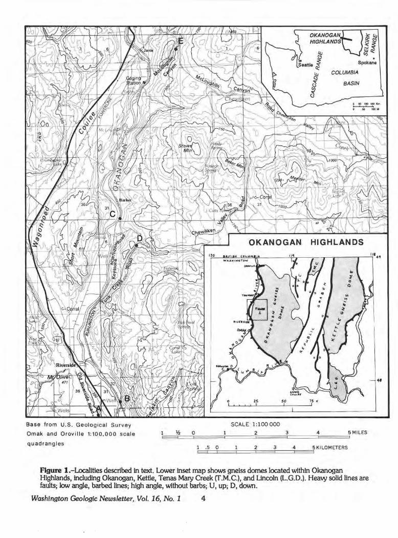
The Okanogan gneiss dome is located in the Okanogan Highlands of north-central Washington, a rolling, mountainous to hilly tract lying north of the Columbia Basin, west of the Selkirk Range, and east of the Cascade Range (Fig. 1). The site is near Riverside, Washington, which can be reached by traveling westward by highway from Spokane, Washington, through Grand Coulee and Omak. The localities described below are primarily road cuts along well-maintained graveled roads that are passable by 2-wheel"rive vehicles. Adjacent lands are private property, except for that northeast of locality B, which is federal land.
SIGNIACANCE OF SITE
The gneiss dome and associated volcanic rocks apparently formed during a conwlsive episode of crustal extension that climaxed about 50 m.y. ago (Medford, 1975; Fox and others, 1976; see also Fox and Beck, 1985, for additional references). Extension of the brittle upper crust through volcano-tectonic collapse (and graben formation) and listric faulting was probably accommodated in the middle and lower crust through ductile flow. We suggest that the dome is a part of the ductile middle crust that flowed laterally and bulged upwards at a crustal pull-apart and finally froze into place within the upper crust in middle Eocene time. The mylonitic rocks at this site evidently formed through shearing at the interface between brittle and ductile regions of the crust. The structural fabric of the interior parts of the dome-fluxion structure, lineation, and intrafolial folding- probably formed as a consequence of ductile flow. It seems likely that prior to the Eocene extensional event, parts of the gneiss dome were at depths of 10 to 20 km. The prevailingly moderate to low dip of the fluxion structure within the dome therefore implies that the horirontal component of tectonic transport of these rocks was at least several times greater than this amount.
by
3
C. Dean Rinehart
U.S. Geological Survey
Menlo Park, CA 94025
SETIING OF OKANOGAN GNEISS DOME
Some areas of medium- to high-grade metamorphic rocks and associated igneous rocks are characterized by penetrative lineation (Fig. 2) and by layering (Fig. 3 ) and metamorphic foliation that is crudely domal in attitude-flat near the center of a given area, and increasingly steeper toward the flanks. The foliation thus defines a large-scale domal structure within a gneissic terrane-hence the appellation "gneiss dome". Four gneiss domes have been defined within the Okanogan Highlands-from west to east, the Okanogan (Fox and Rinehart, 1971), Tenas Mary Creek (Parker and Calkins, 1964), Kettle (Cheney, 1980), and Lincoln (Atwater and Rinehart, 1984) gneiss domes (Fig. 1). The gneiss domes lie within a belt containing scattered gneiss domes that borders the Rocky Mountain thrust belt on the west and extends from central British Columbia southward into Nevada and Arizona (Fox and others, 1977, p. 18). The gneiss domes are commonly partperhaps the major part-of the areas of medium- to high-grade metamorphic rocks ref erred to as metamorphic core complexes (Davis and Coney, 1979).
In map view, the Okanogan gneiss dome (including syntectonic bodies of granite) is approximately 90 km long (north-south dimension), and 45 km wide (east-west dimension). The attitude of foliation and layering within the mass as a whole, though broadly domal, defines three culminations and two troughs (Fig. lA). The penetrative lineation is not uniaxial-its trend swings from N. 60" W. in the western part of the dome to eastwest in the central part, then to N. 60" E. in the eastern part.
Medium- to high-grade metasedimentary and metaigneous rocks of the Upper Cretaceous Tonasket Gneiss form the west-central part of the dome and are flanked on the north, east, and south by orthogneiss. The orthogneiss grades outward to nearly structureless granite. Foliation and lineation are penetrative in much of the western half of the dome, but are progressively less well developed to the east.
Washington Geologic Newsletter, Vol. 16, No. 1
OKANOGAN HIGHLANDS
. Spokane
Base from U.S. Geological Survey
Omak and Oroville 1:100,000 scale
quadrangles
COLUMBIA
BASIN
0 25 50 75 IC
SCALE 1:100 000
~ O 2 3 4 5 MILES E:::::::=t::==::E:::::::=:==:=!::===:==::~====l::=======E::=:====3
1 .5 0 5 KI LOMETERS E=:C:::E=:==:~==::E==3::===.E===3
2 3 4
Figure 1 .-Localities described in text. Lower inset map shows gneiss domes located within Okanogan Highlands, including Okanogan, Kettle, Tenas Mary Creek (T.M.C.), and Lincoln (L.G.D.). Heavy solid lines are faults; low angle, barbed lines; high angle, without barbs; U, up; D, down.
Washington Geo/ogle Newsletter, Vol. 16, No. 1 4
+I
119' 30'
0
0
10
Mt. Hull • Chesaw /
/ Haley Mtn. / .,,.
+' /
119' 15'
20
10
30
48" 15'
Nespelem •
119' 00' m:;
40 Km
20 Mi
Strike and dip of foliation
Okanogan gneiss dome boundary
Thrust fault
Figure lA.-Structures within the Okanogan gneiss dome as indicated by foliation. See inset, lower right, Figure 1, for dome location.
5
Between Omak and Tonasket, Washington, the Tonasket Gneiss is exposed in a spectacular series of west-dipping cuestas carved out of the western flank of the gneiss dome by the Okanogan River and its late-glacial meltwater tributaries (cover photo). The Tonasket Gneiss is informally divided into three compositional units: (1) felsic gneiss; (2) mafic gneiss; and (3) the orthogneiss of Anglin (Fig. 3). Within the map area these units are bordered on the south by the orthogneiss of Omak Lake (Fig. 4). These compositional units are deformed, sheared, and recrystallized to varying degrees. Within the resulting spectrum of dynamically metamorphosed rocks, several different intergradational classes of rock, referred to as structural facies, were defined by Waters and Krauskopf (1941). These facies, with names of the first three modified to accord with the classification ynd terminology of cataclastic rocks by Higgins (1971) are as follows: (1) mylonitic and ultrarnylonitic facies (Ag. 5); (2) protomylonitic facies; (3) blastomylonitic facies (Fig. 3); and (4) swirled gneiss facies (Ag. 6). These structural facies form a coherent map pattern superimposed on the compositional units of the Tonasket Gneiss listed above. In general, the ultramylonite and mylonite form the western margin and grade eastward to protomylonite, which in tum grades to blastomylonite, and that in tum grades eastward to swirled gneiss.
The mylonitic rocks are probably erosional remnants of a formerly continuous mylonitic carapace about 2 km thick that covered the western half of the dome. The contact of that mylonitic carapace with country rock south and west of the dome is commonly covered, but at the several places where it is exposed or closely bracketed by outcrop it is marked by a 5- to 10-m-thick zone of chloritic breccia and microbreccia.
DESCRIPTION OF LOCALITIES
The principal features of the gneiss dome can be observed at outcrops along secondary roads near Riverside and Tonasket. These communities are situated along U.S. Highway 97, which follows the alluviated
1 Higgins ( 1971) divides cataclastic rocks into two broad groups according to whether or not they have fluxion structure (a cataclastically produced foliation). Those that do are further subdivided according to whether cataclasis was dominant over recrystallization (protomylonite, mylonite, ultramylonite) or the reverse (mylonite gneiss, blastomylonite). Following Higgins (1971), we define the following rocks: Ultramylonite-Consists of sparse porphyroclasts generally less than 0.2 mm in diameter dispersed through an aphanitic matrix of finely crushed minerals. Mylon!te-Consists of 10 to 50 percent porphyroclasts generally larger than O .2 mm embedded in an aphanitic to very fine grained matrix of crushed minerals. Protomylonite-Consists of lenticular masses of rock separated by megascopic gliding surfaces filled with finely crushed rock. Blastomy/onite-Similar in megascopic fabric to the rocks listed above, but porphyroclasts are embedded in a granular mosaic of unstrained, metamorphically recrystallized minerals.
Washington Geologic Newsletter, Vol. 16, No. 1
valley of the Okanogan River northward from its confluence with the Columbia River near Brewster to Oroville (Fig. 1).
From Omak to Oroville, a distance of 60 mi, Highway 97 approximately follows the western contact of the gneiss dome, which is concealed beneath the alluvium, terrace deposits, and fan deposits of the Okanogan River and tributary streams.
The five localities described below are indicated on Figure 1 and can be visited in any order. For the convenience of those interested in a more formal program, we include a brief road log.
Beginning point. Intersection of U.S. Highway 97 and Old Riverside
Road, on southern outskirts of Riverside. From this intersection, proceed south on Old Riverside Road approximately 1.8 mi to locality A. Park off east side of highway at intersection with access road to power line to east.
Locality A. This vantage point overlooks the western flank of the
gneiss dome (Fig. 7). The prominent valley to the northnorthwest is Wagonroad Coulee, an abandoned segment of the pre-glacial channel of the Okanogan River. The rocky cliffs forming the western wall of the coulee expose Triassic dolomite and limestone of the Cave Mountain Formation (Rinehart and Fox, 1976). The contact with the gneiss dome, concealed by glacial drift, is probably located near the axis of the coulee. The low hills on the east of the coulee are underlain by mylonitic
Washington Geologic Newsletter, Vol. 16, No. 1 6
Figure 2.-Lineation (parallel to pocket knife) on foliation planes within porphyrolastic orthogneiss (orthogneiss of Omak Lake, 3 mi (5 km) east of Omak). (This photo and other figures, this article, courtesy of K. F. Fox, Jr., USGS.)
to protomylonitlc orthogneiss of the gneiss dome. The strike of foliation (fluxion structure) in the orthogneiss parallels the westwardly convex curvilinear trace of Wagonroad Coulee: the dip is westward 15· to 20· steepening to 60. near H1e Okanogan River north of Riverside. The erosional form of the west-dipping cuestas ~arking the western margin of the gneiss dome (and visible to the north) is controlled by this foliation.
The prominent southwest-sloping wall of rock east of our position exposes mylonitic granitic gneiss at the stripped and eroded exterior surf ace of the gneiss dome. Southeastward, the gneiss dome underlies almost all of the upland in view east of the Okanogan River. Bedrock west of the river consists of volcanic breccia and lava flows of probable F.ocene age. The contact between these rocks and the gneiss dome is concealed beneath the terraced gravel deposits and alluvial deposits flooring the Okanogan River valley. Farther south the western contact is clearly a fault rone dipping west at a moderate to low angle and marked by chlorite breccia (Goodge and Hansen, 1983). Snook (1965) hypothesized that movement on the fa ult forming the western contact was distributed through the 2-km-thick mylonitic carapace of the gneissic rocks to the east.
Return to junction of Old Riverside Road and Highway 97. Cross Highway 97 and continue northward 0.4 mi into Riverside. Tum right (northeastward) on Tunk Creek road and proceed 0.25 mi, crossing Okanogan River and railroad tracks. At road junction, turn south and proceed approximately 2.0 mi to locality B.
Locality B.
Park off road on western shoulder. Road cut on east side of road exposes medium light gray porphyroclastic mylonitic granite gneiss containing felsic layers as much as 1 cm thick, medium gray microporphyroclastic layers as much as 5 cm thick, and black ultramylonite layers ~s much as 1 cm thick. The gneiss is penetratively lmeated and foliated. The mylonitic foliation strikes N. 25 • E., and dips 33· to 40· to the west-northwest. Layering and foliation are generally concordant. The lineation lies in the plane of foliation and trends N. 3r W. Several high-angle micro-faults striking N. 35· E. to N. 60. E. offset layering vertically about 2 cm.
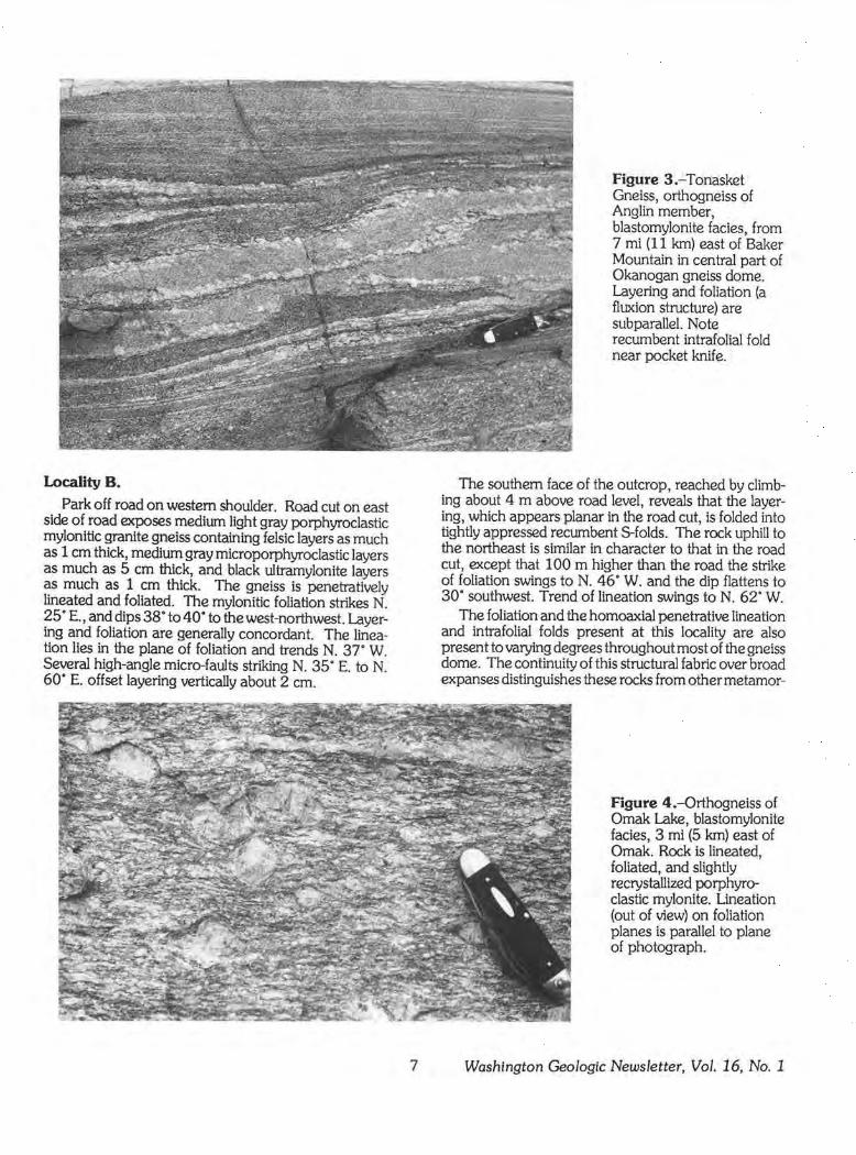
Figure 3.- Tonasket Gneiss, orthogneiss of Anglin member, blastomylonite f acies, from 7 mi (11 km) east of Baker Mountain in central part of Okanogan gneiss dome. Layering and foliation (a fluxion structure) are subparallel. Note recumbent intrafolial fold near pocket knife.
The southern face of the outcrop, reached by climbing about 4 m above road level, reveals that the layering, which appears planar in the road cut, is folded into tightly appressed recumbent S-folds. The rock uphill to the northeast is similar in character to that in the road cut, except that 100 m higher than the road the strike of foliation swings to N. 46. W. and the dip flattens to 30· southwest. Trend of llneation swings to N. 62. W.
The foliation and the homoaxial penetrative lineation and intrafolial folds present at this locality are also present to varying degrees throughout most of the gneiss dome. The continuity of this structural fabric over broad expanses distinguishes these rocks from other metamor-
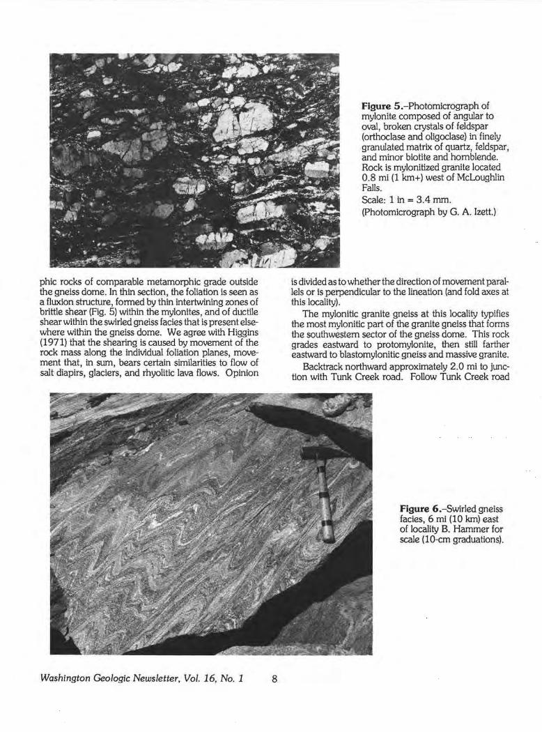
Figure 4.-0rthogneiss of Omak Lake, blastomylonite fades, 3 mi (5 km) east of Omak. Rock is lineated, foliated, and slightly recrystallized porphyroclastic mylonite. Lineation (out of view) on foliation planes is parallel to plane of photograph.
7 Washington Geologic Newsletter, Vol. 16, No. 1
phic rocks of comparable metamorphic grade outside the gneiss dome. In thin section, the foliation is seen as a fluxion structure, formed by thin intertwining zones of brittle shear (Fig. 5) within the mylonites, and of ductile shear within the swirled gneiss facies that is present elsewhere within the gneiss dome. We agree with Higgins (1971) that the shearing is caused by movement of the rock mass along the individual foliation planes, movement that, in sum, bears certain similarities to flow of salt diapirs, glaciers, and rhyolitic lava flows. Opinion
Washington Geologic Newsletter, Vol. 16, No. 1 8
Figure 5 .-Photomicrograph of mylonite composed of angular to oval, broken crystals of feldspar (orthoclase and oligoclase) in finely granulated matrix of quart.z, feldspar, and minor biotite and hornblende. Rock is mylonitized granite located 0.8 mi (1 km+) west of Mcl oughlin Falls. Scale: 1 in= 3.4 mm. (Photomicrograph by G. A. lzett.)
is divided as to whether the direction of movement parallels or is perpendicular to the lineation (and fold axes at this locality).
The mylonitic granite gneiss at this locality typifies the most mylonitic part of the granite gneiss that forms the southwestern sector of the gneiss dome. This rock grades eastward to protomylonite, then still farther eastward to blastomylonitic gneiss and massive granite.
Backtrack northward approximately 2.0 mi to junction with Tunk Creek road. Follow Tunk Creek road
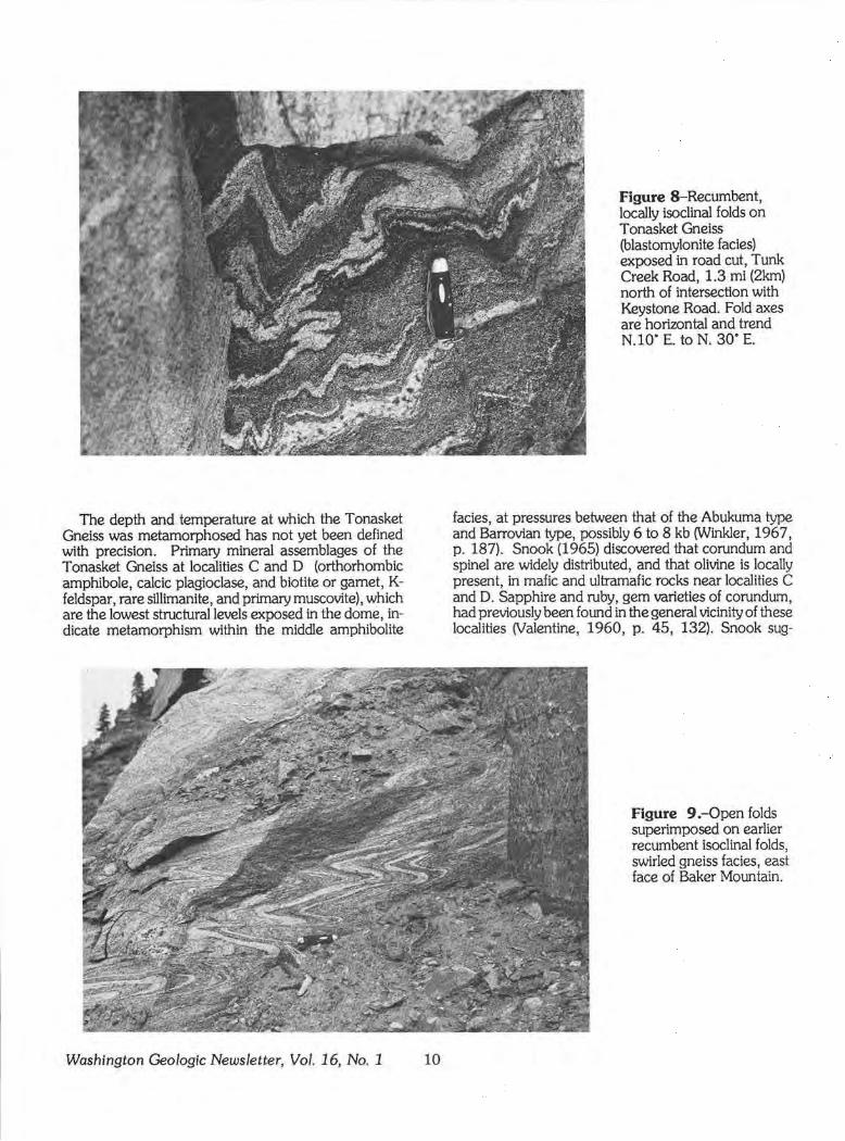
Figure 6.-Swirled gneiss facies, 6 mi (10 km) east of locality B. Hammer for scale (10-cm graduations).
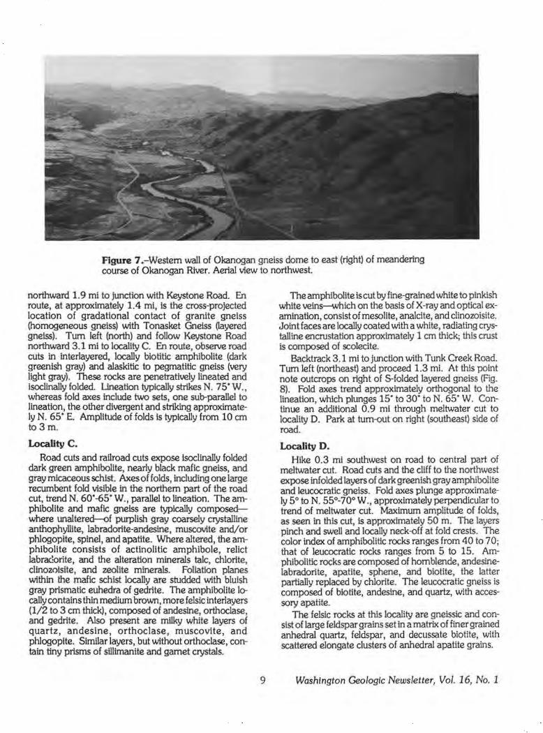
Figure 7 .-Western wall of Okanogan gneiss dome to east (right) of meandering course of Okanogan River. Aerial view to northwest.
northward 1.9 mi to Junction with Keystone Road. En route, at approximately 1.4 ml, Is the cross-projected location of gradatlonal contact of granite gneiss (homogeneous gneiss) with Tonasket Gneiss Oayered gneiss). Tum left (north) and follow Keystone Road northward 3.1 mi to locality C. En route, observe road cuts in interlayered, locally biotitlc amphibolite (dark greenish gray) and alaskitic to pegmatitic gneiss (very light gray). These rocks are penetratively lineated and isoclinally folded. Uneation typically strikes N. 75• W., whereas fold axes include two sets, one sub-parallel to lineation, the other divergent and striking approximately N. 65· E. Amplitude of folds ls typically from 10 cm to3 m.
Locality C. Road cuts and railroad cuts expose isoclinally folded
dark green amphibolite, nearly black mafic gneiss, and gray micaceous schist. Axes of folds, including one large recumbent fold visible in the northern part of the road cut, trend N. 60.-65. W., parallel to lineation. The amphibolite and mafic gneiss are typically composedwhere unaltered-of purplish gray coarsely crystalline anthophyllite, labradorite-andesine, muscovite and/or phlogopite, spine!, and apatite. Where altered, the amphibolite consists of actinolitic amphibole, relict labra<lorite, and the alteration minerals talc, chlorite, clinozolsite, and zeolite minerals. Foliation planes within the mafic schist locally are studded with bluish gray prismatic euhedra of gedrite. The amphibolite ler cally contains thin medium brown, more felsic interlayers (1/2 to 3 cm thick), composed of andesine, orthoclase, and gedrite. Also present are milky white layers of quartz, andesine, orthoclase, muscovite, and phlogoplte. Similar layers, but without orthoclase, contain tiny prisms of silllmanite and garnet crystals.
9
The amphibolite is cut by fine-grained white to pinkish white veins--which on the basis of X-ray and optical examination, consist of mesolite, analcite, and clinozoisite. Joint faces are locally coated with a white, radiating crystalline encrustation approximately 1 cm thick; this crust is composed of scolecite.
Backtrack 3.1 mi to junction with Tunk Creek Road. Tum left (northeast) and proceed 1.3 mi. At this point note outcrops on right of $-folded layered gneiss (Fig. 8). Fold axes trend approximately orthogonal to the lineation, which plunges 15· to 30· to N. 65. W. Continue an additional 0.9 mi through meltwater cut to locality D. Park at tum-out on right (southeast) side of road.
Locality D. Hike 0.3 ml southwest on road to central part of
meltwater cut. Road cuts and the cliff to the northwest expose infolded layers of dark greenish gray amphibolite and leucocratic gneiss. Fold axes plunge approximately 5° to N. 55°-70° W. , approximately perpendicular to trend of meltwater cut. Maximum amplitude of folds, as seen in this cut, is approximately 50 m. The layers pinch and swell and locally neck-off at fold crests. The color index of amphibolitic rocks ranges from 40 to 70; that of leucocratic rocks ranges from 5 to 15. Amphibolitic rocks are composed of hornblende, andesinelabradorite, apatite, sphene, and biotite, the latter partially replaced by chlorite. The leucocratic gneiss is composed of biotite, andeslne, and quartz, with accessory apatite.
The f elsic rocks at this locality are gneissic and consist of large feldspar grains set in a matrix of finer grained anhedral quartz, feldspar, and decussate biotite, with scattered elongate clusters of anhedral apatite grains.
Washington Geologic Newsletter, Vol. 16, No. 1
The depth and temperature at which the Tonasket Gneiss was metamorphosed has not yet been defined with precision. Primary mineral assemblages of the Tonasket Gneiss at localities C and D (orthorhombic amphibole, calcic plagioclase, and biotite or garnet, Kfeldspar, rare sillimanite, and primary muscovite), which are the lowest structural levels exposed in the dome, indicate metamorphism within the middle amphibolite
Washington Geologic Newsletter, Vol. 16, No. 1 10
Figure 8-Recumbent, locally isoclinal folds on Tonasket Gneiss (blastomylonlte facies) exposed in road cut, Tunk Creek Road, 1.3 ml (2km) north of intersection with Keystone Road. Fold axes are horizontal and trend N.10· E. to N. 30· E.
facies, at pressures between that of the Abukuma type and Barrovian type, possibly 6 to 8 kb (Winkler, 1967, p. 187). Snook (1965) discovered that corundum and spine! are widely distributed, and that olivine is locally present, in mafic and ultramaf ic rocks near localities C and D. Sapphire and ruby, gem varieties of corundum, had previously been found in the general vicinity of these localities (Valentine, 1960, p. 45, 132). Snook sug-
Figure 9 .-Open folds superimposed on earlier recumbent isoclinal folds, swirled gneiss facies, east face of Baker Mountain.
gested that the rocks in this area had been retrograded from granulite facles, perhaps implying metamorphism at even greater temperature and pressure.
Regional gravity highs associated with the gneiss domes suggest that (1) the domes are the surface expression of a zone of dense infrastructure and (2) that the deep cores of the gneiss domes contain pelitic or mafic rocks rather than granitic rocks (Cady, 1980). Hence the gradation from mafic and ultramafic rocks at localities C and D to f els!c rocks at structurally higher levels (of localities B and E) may correlate with compositional changes attributed to compositional zonation found elsewhere at mid-crustal depths (Hamilton, 1981). If so, these rocks are a tectonically much-thinned premiddle Eocene crust.
Return to vehicle and drive 2. 7 mi eastward to junction with Chewiliken Valley Road. The route crosses interlayered amphlbolite and felsic gneiss, locally mantled by glacial drift. Tum left (north) at the road junction and proceed northward on Chewiliken Valley Road. At Baker Mountain, approximately 3.6 mi north of the road junction, note the high cliffs to the west that form the western wall of a deep meltwater cut. The cliffs expose flat-lying, thinly layered, multiply folded gneiss (Fig. 9). These rocks are part of the swirled gneiss facles (Fig. 6) of Waters and Krauskopf (1941). An early foliation, defined by thin layers of moderately contrasting color index, is closely folded and cross-cut by a later generation of nearly flat-lying sub-planar foliations spaced 2 to 15 cm apart. The peculiar fabric of the swirled gneiss, as seen between localities D and E, may have formed through ductile flow in a two-stage process: (1) initial turbulent flow (the swirling of early foliation), and (2) subsequent laminar flow (forming the later crosscutting fluxion structure). The west-northwest lineation typical of the dome ls present on both the early and later foliation surfaces.
Continue northward and then eastward 1.4 mi to junction with McLoughlin Canyon Road. Tum left at this road junction, and follow Mcloughlin Canyon Road 5.3 mi to locality E. Park on shoulder or off road to left (south) at tum-out at westernmost switchback. A sign identifies this as a historical site.
Locality E. The deep meltwater cut to west is McLoughlin Canyon.
Road cuts and cliffs expose lineated, thinly interlayered granitoid gneiss and gnelssic pegmatite dipping 20° to 30° to the northwest (Fig. 2). Dark layers visible in the distance to the northwest and north are amphibolitic gneiss. The overall aspect of the gneiss is that of a homoclinal sequence of zones several meters to several tens of meters thick and distinguished only by differences in color index. Within some zones, however, the gneiss Is highly folded on a small scale. Most folds are recumbent, highly appressed, with fold axes subparallel to the lineation, which is ubiquitous and plunges in the plane of the foliation approximately N. 55° W. A younger set of small~scale folds is overprinted on the older set in places,
11
as can be observed at road cuts in the upper part of the road grade approximately 0.2 mi to the west. These small-scale folds are generally open, with steeply dipping axial planes, and have fold axes that strike, on average, about north-northeast, nearly perpendicular to the lineation.
The gneiss at this locality is cut by unfoliated steeply dipping alaskite-pegmatite dikes, 5 to 20 cm thick, which, like the later folds, strike north-northeast.
The gneiss dome probably formed during a regional episode of west-northwest extension. However, the late-stage north-northeast-trending folds suggest westnorthwest compression, possibly reflecting partial deflation of the dome through outflow of its deeper and still ductile parts. The later north-northeast-trending dikes imply renewed west-northwest extension.
Continue westward on Mcloughlin Canyon road, rejoining Highway 97 approximately 2.5 mi west of Locality E.
Acknowledgments The authors are grateful to B. F. Atwater, J. W.
Goodge, V. L. Hansen, W. Holder, G. A McCarley Holder, J.C. Moore, S. H. Singer, andJ. R. Wilson for contributing their observations and ideas about the evolution of the gneiss dome during many spirited campfire and field discussions.
REFERENCES CITED
Atwater, B. F.; Rinehart, C. D., 1984, Preliminary geologic map of the Colville Indian Reservation, Ferry and Okanogan Counties, Washington: U.S. Geological Survey Open-File Report 84-389, 1 sheet with pamphlet, scale 1: 100,000.
Cady, J. W., 1980, Gravity highs and crustal structure, Omineca crystalline belt, northeastern Washington and southeastern British Columbia: Geology, v. 8, no . 7, p. 328-332.
Cheney, E. S., 1980, Kettle dome and related structures of northeastern Washington: Geological Society of America Memoir 153, p. 463-483.
Davis, G. H.; Coney, P. J., 1979, Geologic development of the Cordilleran metamorphic core complexes: Geology, v. 7, no. 3, p. 120-124.
Fox, K. F., Jr.; Beck, M. E., Jr., 1985, Paleomagnetic results for Eocene volcanic rocks from northeastern Washington and the Tertiary tectonics of the Pacific Northwest: Tectonics, v. 4, no. 3, p . 323-341.
Fox, K. F., Jr.; Rinehart, C. D., 1971, Okanogan gneiss dome [abstract). In Metamorphism in the Canadian Cordillera: Program and abstracts, Canada Geological Association, Cordilleran Section Meeting, Vancouver, British Columbia, p . 10.
Fox, K. F., Jr.; Rinehart, C. D.; Engels, J.C.; Stem, T. W., 1976, Age of emplacement of the Okanogan gneiss dome, north-central Washington: Geological Society of America Bulletin, v. 87, no. 9, p. 1217-1224.
Washington Geologic Newsletter, Vol. 16, No. 1
Fox, K. F., Jr.; Rinehart, C. D; Engels, J. C., 1977, Plutonism and orogeny in north-central Washington- Timing and regional context: U.S. Geological Survey Professional Paper 989, 27 p.
Goodge, J. W.; Hansen, V. L., 1983, Petrology and structure of rocks in the southwest portion of Okanogan dome, north-central Washington: Northwest Geology, v. 12, p. 13-24.
Hamilton, Warren, 1981, Crustal evolution by arc magmatism: Philosophical Transactions of the Royal Society of London, v. A-301, p. 279-291.
Higgins, M. W., 1971, Cataclastic rocks: U.S. Geological Survey Professional Paper 687, 97 p.
Medford, G. A., 1975, K-Ar and fission track geochronometry of an Eocene thermal event in the Kettle River (West Half) Map Area, southern British Columbia: Canadian Journal of Earth Sciences, v. 12, p. 836-843.
Parker, R. L.; Calkins, J. A., 1964, Geology of the Curlew quadrangle, Ferry County, Washington: U.S. Geological Survey Bulletin 1169, 95 p.
Rinehart, C. D.; Fox, K. F., Jr., 1976, Bedrock geology of the Conconully quadrangle, Okanogan County, Washington: U.S. Geological Survey Bulletin 1402, 58 p.
Snook, J. R., 1965, Metamorphic and structural history of "Colville Batholith" gneisses, north-central Washington: Geological Society of America Bulletin, v. 76, no. 7, p. 759-776.
Valentine, G. M., 1960, Inventory of Washington minerals, Part I, Nonmetallic minerals 2d edition revised by M. T. Huntting: Washingto~ Division of Mines and Geology Bulletin 37, v. 1, 175 p.
Waters, A. C.; Krauskopf, Konrad, 1941, Protoclastic border of the Colville Batholith (Washington): Geological Society of America Bulletin v. 52 p. 1355-1417. ' '
Winkler, H. G. F., 1967, Petrogenesisof Metamorphic Rocks; revised second edition: New York, Springer Verlag, 237 p.
STAFF NOTES
Nancy L. Joseph presented a paper "Highlights of Mineral Development in Washington, 1987" at the 93rd annual Northwest Mining Association convention in Spokane in early December. She also gave two talks at the October meeting of the Washington Science Teachers Association; the titles of the talks were "Innovative ideas for local geologic adventures" and "What do we mine and what Is it used for?"
Timothy J. Walsh will be teaching an introductory geology course at the South Puget Sound Community College.
Washington Geologic Newsletter, Vol. 16, No. 1 12
LIFE CYCLE OF A MINERAL PROPERTY
(Continued from page 2)
A ORE PRODUCING EXHAUSTION ,.... PROPERTIES POOR
ECONOMICS
r B IMPROVED D
DEVELOPMENT ECONOMICS - PROPERTIES POOR DORMANT ECONOMICS
r PROPERTIES
YINS WITH BU
C IMPROVED RESOURCES
,... PRE-DEVELOPMENT ECONOMICS
PROPERTIES POOR ECONOMICS
l HIGH CARRYING
E COSTS SPECULATIVE NEGATIVE .... PROPERTIES RESULTS
f GRASSROOTS F
PROJECTS DEAD -PROPERTIES
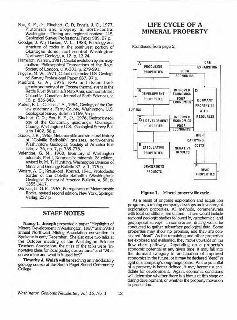
Figure !.-Mineral property life cycle.
As a result of ongoing exploration and acquisition programs, a mining company develops an inventory of exploration properties. All methods, commensurate with local conditions, are utilized. These would include regional geologic studies followed by geochemical and geophysical surveys. In some areas, drilling would be conducted to gather subsurface geological data. Some properties may show no promise, and they are considered "dead". As the remaining and other properties are explored and evaluated, they move upwards on the flow chart pathway. Depending on a property's economic potential at any given time, It may fall into the dormant category in anticipation of improved economics in the future, or it may be declared "dead" in light of a company's long-range plans. As the potential of a property is better defined, it may become a candidate for development. Again, economic conditions will determine whether there is a hiatus at this stage or during development, or whether the property moves on to production.
Companies may buy in (obtain part interest in) properties at virtually any stage in their life cycle. The factors that determine the pathway remain the same, however.
A brief definition of each mineral property class follows:
A. Producing Properties: Properties with current full-scale economic production.
B. Development Properties: Properties for which there are current plans for production supported by a feasibility study or detailed pre-development study that demonstrates economic viability based on proven reserves and a tested metallurgical process.
C. Pre-Development Properties: Properties for which feasibility studies are planned or are in progress and which demonstrate potential economic viability and have reserves based on preliminary drilling and/ or geologic study.
D. Dormant Properties with Resources: Properties with significant mineral deposits currently believed to be uneconomic but with potential for future development.
E. Speculative Properties: Properties with definite indications of economic mineralization but without suf-
ficient data to determine the extent or economic viability of same except by reference to mines in the area or a favorable geologic setting.
F. Dead Properties: Properties with exhausted ore reserves or without potential for future economic development or sale which are being held pending the lapse of claims or expiration of mineral leases.
Note than favorable or poor economics drive the classification. Poor economics may be due to a recession, unreasonable lease terms compared to the grade of ore, escalating operating costs due to inflation, high cost of venture capital, or refractory ores for which a successful metallurgical process was not found.
On the other hand, breakthroughs in metallurgy, rising mineral commodity prices compared to other costs, renegotiation of royalty agreements, or introduction of favorable taxation laws may move a property from dormancy to development and production.
Taking a prospect through all of the stages to a producing mine is full of risks and requires complex analyses in geology, metallurgy, engineering, and finance. Environmental considerations also play an important role in today's decision-making process.
Washington's Nonfuel Mineral Industry in 1987 The estimated value of nonfuel mineral production in
Washington for 1987 was $402 million, an increase of nearly 7 percent from that recorded in 1986, according to the Bureau of Mines, U.S. Department of the Interior. Increases in the production of gold, sand and gravel, and silver contributed largely to the gain. Nonmetallic minerals accounted for about 51 percent of the State's nonfuel mineral value. Washington ranked 20th nationally in that value in 1987.
Witco Chemical Corp. produced diatomite from two pits in Grant County. Columbia River Carbonates produced ground limestone from stockpiled material at the Woodland plant. Silica was produced in Stevens County by Lane Mountain Silica Co, in Pend Oreille County by Bockman Construction Co., and by L-Bar Products and Ash Grove Cement West in King County. Dolomite was produced from several quarries in Stevens County. AIMCOR produced olivine from the Twin Sisters quarry, Skagit County, and Olivine Corp. mined olivine in Whatcom County. Production from the state's four cement plants declined in 1987; Columbia Northwest Cement Corp., Bellingham, was sold in September to Tillbury Cement Co., of Delta, British Columbia, Canada. Interpace Industries began expansion of the Mica brick plant, Spokane County.
Asamera Minerals (U.S.) Inc. produced at capacity at the Cannon gold mine, Wenatchee. Hecla Mining Co. dedicated the Golden Promise shaft at the Republic Unit., Ferry County, and continuied production and development on the Golden Promise ore zone. Vulcan
13
Mountain Inc. continued precious metal production at the Gold Dike and Gold Hill properties near Danville. Echo Bay Mines Ltd. explored for gold at four sites in the Kettle River project, and Newmont Exploration Ltd., ASARCO Inc. , Westmont Mining Inc., and U.S. Borax & Chemical Corp. explored for precious metals in Ferry County. Steelhead Resources Ltd. explored and planned redevelopment at the old Great Excelsior gold-silvar mine, Whatcom County.
Washington's depressed aluminum industry made a partial recovery during the year. Vanalco reopened the former Aluminum Co. of America (Alcoa) smelter at Vancouver, and Columbia Amuminum Co. purchased and restarted the former Commonwealth Aluminum Co. reduction plant at Goldendale. Kaiser Aluminum & Chemical Corp. restarted two potlines at the Mead smelter, bringing the plant up to 87 percent of full capacity. Reynold Metals Co. , Vanalco, and Kaiser Aluminum applied to the Bonneville Power Administration (BPA) to modernize their smelters under BPA's conservation and modernization incentive program. Northwest Alloys, an Alcoa subsidiary, operated a magnesium metal plant near Addy at full capacity in 1987.
(Text from a Bureau of Mines release, January 1988. Prepared in the Bureau's Spokane Regional Office in cooperation with the Washington Division of Geology and Earth Resources.)
NOTE: The Division's annual summary of mineral exploration and production will appear in the spring newsletter.
Washington Geologic Newsletter, Vol. 16, No. 1
State Releases Revised Mining and Prospecting Regulations
by
Ronald F. Teissere Washington Department of Natural Resources
Division of Land Leasing and Recreation
The new rules implementing the statutory changes made to the state of Washington's laws governing the leasing of state-owned mineral rights were adopted on October 9, 1987, and became effective November 10, 1987. The basic procedures for obtaining mineral leases remain unchanged. The major changes were made to the annual rental, advance minimum royalty payments, the length of the term of a prospecting lease, and the ability of the Department of Natural Resources to use public auction procedures to issue placer gold mining contracts and to designate areas for recreational prospecting. A new requirement, the submission of a plan of operations, was added. The plan of operations must be approved by the Department prior to the commencement of any prospecting operations. Notice of the dates that prospecting or mining operations are expected to begin each year must also be given to the Department.
Minor changes were made in a number of areas to bring the rules into compliance with the statutory changes and to clarify requirements. The sections most affected by the changes were those dealing with timber, surface rights, prospecting and development work, and the submission of technical data.
The rental rates, advance minimum royalty rates, and application fees are now set by the Board of Natural Resources. The application fee for mineral leases is now $25.00, consistent with the applications fee for other types of leases issued by the Department.
The term of a prospecting lease can now be for up to seven years. Most upland leases will be issued for the full seven years, while most leases for aquatic lands will generally be issued for short terms, usually one to two years. This approach recognizes the blurred distinction between prospecting and mining when using dredging equipment. Mining contracts issued on conversion of a prospecting lease for both uplands and aquatic lands will be for a full twenty years, with no deduction for the prospecting period. Mining contracts issued at public auction for placer gold mining will have five-year terms.
Prior to commencement of work on the property, the holders of prospecting leases must submit a detailed plan of operations to the Department for approval. Plans calling for extensive disturbance of the surf ace, or other significant environmental impacts may require an analysis of the environmental impacts in accordance with the State Environmental Policy Act. The lessee is required to keep operations within the scope of the ap-
Washington Geologic Newsletter, Vol. 16, No. 1 14
proved plan. All proposed changes to the plan must be submitted to the Department for approval. A detailed plan of mine development, which also addresses reclamation, must be submitted at the time a prospecting lease holder applies to convert a prospecting lease to a mining contract. All aspects of the mine development plan and the reclamation plan need to be addressed in the environmental checklist that accompanies it.
Finally, the prospecting lease and mining contract documents have been revised to incorporate the statutory and rule changes, as well as some changes to other statutes that affect prospecting and mining operations, such as the laws dealing with hazardous waste.
CHAPTER 332-16 WAC
Mineral Prospecting Leases and Mining Contracts
WAC 332-16-035 Prospecting Leases and Mining Contracts- Rental Rates, Advance Minimum Royalty, Prospecting Work Requirement, Development Work Requirement and Production Royalty. The annual rental for years one through three of a mineral prospecting lease shall be $2.00 per acre, or $100. 00, whichever is greater. The annual rental for years four through seven of the lease shall be $3. 00 per acre, or $120. 00, whichever is greater. The department may require that more than one year's annual rental be paid in advance prior to issuing the lease.
The annual prospecting work requirement for a mineral prospecting lease shall be $3.00 per acre.
The annual advance minimum royalty for years one through five of a mining contract shall be $5.00 per acre, or $250.00, which ever is greater. The annual advance minimum royalty for years six through ten of a mining contract shall be $10.00 per acre, or $500.00, whichever is greater. The annual advance minimum royalty for years eleven through twenty of a mining contract shall be $20. 00 per acre, or $1,000.00, whichever is greater. ·
The production royalty rate for mining contracts shall be 5% of the gross receipts. The rate to be incorporated into a mining contract issued upon conversion from a prospecting lease shall be the rate in effect on the date the prospecting lease was issued.
The annual development work requirement for a mining contract shall be $5.00 per acre.
All annual rental payments and annual advance minimum royalty payments must be made in advance, and lack of notice of payment due does not relieve the lessee of the obligation to make payments when due.
WAC 332-16-045 Recreational Prospecting Permit Fee. The fee for an annual permit for prospecting and collecting in designated recreational prospecting areas shall be $1 O. 00.
WAC 332-16-055 Application for Prospecting Lease. Applications for prospecting leases will be received during business hours in the office of the Department of Natural Resources, Olympia, Washington. Applications must be submitted on forms prescribed by the department and accompanied by the application fee.
All applications received by any means other than United States Mail will be stamped with the date and time of receipt in the Olympia office. Applications received by United States Mail will be considered received as of the close of business on that day. Applications will be accepted in the order received and priority of leasing will be established on this basis. The priority among applications filed simultaneously will be by drawIng of lots.
If an application is rejected by the department, the application fee will be refunded and the applicant informed of the reason for rejection. If a portion of the lands applied for are encumbered or otherwise not available, such portion will be deleted from the application and the applicant notified of the change.
WAC 332-16-065 Conversion of a Prospecting Lease to a Mining Contract. An application to convert a prospecting lease to a mining contract must be submitted to the department at least one hundred eighty days prior to the expiration of the prospecting lease, together with the application fee.
The application shall include a plan of development which describes the development, operation and reclamation of the property, an environmental checklist and evidence that the prospecting work requirements of the lease have been met.
WAC 332-16-075 Prospecting Lease Not Renewable. A prospecting lease not converted to a mining contract shall not be renewable. The holder of an expired prospecting lease, or the holder's agents, shall not be entitled to a new lease on the premises covered by the prior lease for one year from the date of the expired prospecting lease.
WAC 332-16-085 Failure to Execute Prospecting Leases and Mining Contracts. When an applicant fails to sign a lease or contract and return the signed document with the rental or minimum royalty within thirty days, the application will be rejected and the application fee forfeited. Additional time for compliance with this section may be granted by the department if the applicant submits a written request for
15
additional time to the department within the thirty day period.
WAC 332-16-095 Renewal of Mining Contract. The lessee may apply for renewal of a mining contract, except placer gold mining contracts issued pursuant to RCW 79.01.617, by submitting an application, and the application fee, within the ninety days prior to the expiration of the contract.
The terms of the renewal contract shall be the same as those contained in the previous contract unless valuable minerals or specified materials are not being produced. The terms of a renewal contract on.a nonproducing lease shall be governed by the rules and rates in effect at the time the renewal contract is issued.
WAC 332-16-105 Performance Security. The department may, at its option, require the lessee to file a cash bond, savings account assignment, approved corporate surety bond or other form of security satisfactory to the department in an amount sufficient to guarantee performance of the terms and conditions of the lease or contract. Such security, if required, shall be submitted prior to the commencement of prospecting or mining operations. The department may reduce or increase the amount of the security as a result of operational changes requiring different levels of performance. The department may allow a lessee to file a single security device, acceptable to the state, in an amount set by the department covering all of the lessee's state leases.
WAC 332-16-115 Timber. No forest products owned by the department shall be cut, removed or destroyed unless approved In advance by the department. The lessee shall appropriately mark all forest products proposed to be cut. Unless the department elects to directly dispose of the forest products, the department will appraise the forest products and the lessee shall pay the appraised value of such forest products within thirty days of billing unless there is a written extension of time by the department, and in any event, prior to their cutting.
WAC 332-16-125 Surface Rights. Where the surf ace rights for the lands described in the prospecting lease or mining contract are held by a third party, the holder of the prospecting lease or mining contract shall make arrangements with the holder of the surface rights to protect the surf ace interests and submit to the department evidence of such arrangements, prior to the commencement of prospecting or mining activities, in one of the following forms:
(1) Waiver of Damages executed by the holder(s) of the surface rights;
(2) Agreement In the form of a letter, contract or memorandum of understanding executed by both the mineral lessee and the holder(s) of the surface rights which provides for the settlement of all disputes and damages;
(3) A court order resolving the issues of access, damage claims and other disputes.
Washington Geologic Newsletter, Vol. 16, No. 1
WAC 332-16-135 Use of Leased Premises. The holder of a prospecting lease may use the leased premises as provided in the lease and the approved plan of operations, subject to existing rights and payments as otherwise provided. Such uses shall be those reasonably necessary for the exploration of the premises.
The holder of a prospecting lease may remove valuable minerals or specified materials of a value not exceeding $100 for the purpose of testing and assaying. The removal of valuable minerals or specified materials in excess of this amount requires prior written approval of the department, and may be subject to the payment of royalties.
The holder of a mining contract may use the leased premises as provided in the contract and the approved plan of operations, subject to existing rights and payment as otherwise provided. Such uses shall be those reasonably necessary for the exploration, development, operation and production of valuable minerals or specified materials.
WAC 332-16-145 Prospecting and Development Work. Prospecting leases shall require that the lessee perform the required annual prospecting work that contributes to the mineral evaluation of the premises. The lessee may make payment to the department in lieu of prospecting work for not more than three years during the term of the lease.
Mining contracts, except those issued for placer gold mining pursuant to RCW 79.01.617, shall require that the lessee perform the required annual development work that contributes to the mineral development of, and production from, the property. The lessee may make payment to the department in lieu of the performance of development work.
Prospecting work or development work actually accomplished during any one lease or contract year in excess of the lease or contract requirements may be applied toward the next succeeding year only, provided that the work is reported to the department at the end of the year in which it was performed, accompanied by a written request that the excess be applied to the next succeeding year.
All prospecting and development work reported is subject to evaluation and confirmation by the department. Work that does not directly contribute to the mineral evaluation or development of the property will not be accepted. The department shall have the right to inspect the work done and to examine all books and records pertaining to prospecting and development work reported. Prospecting and development work reports shall contain sufficient information, including adequate maps, plans, diagrams, locations, and costs to indicate the location, amount and type of work accomplished on or adjacent to the property and an explanation of how this work contributed to the mineral evaluation or development of the property.
Washington Geologic Newsletter, Vol. 16, No. 1 16
Upon the written request of the lessee at the time the prospecting or development work report is submitted to the department, the report shall be considered confidential until a written release is obtained from the lessee or the termination, cancellation, surrender or expiration of the lease or contract.
WAC 332-16-155 Production Royalty.Production royalties shall be payable as provided in the mining contract upon all valuable minerals, specif led materials or any products whatever which are mined, saved, sold or removed from the leased premises.
The production royalty shall be calculated on the gross receipts, including all bonuses and allowances paid, earned, or received, at the point of sale of the first marketable valuable mineral(s) produced from the leased premises, whether or not such valuable mineral(s) are produced through chemical or mechanical processes, subject only to the deduction of transportation costs which transportation costs are part of the development plan approved by the department.
The department may set or calculate the production royalty in the case of specified materials and other products produced from the leased premises based on the volume of material removed from the leased premises.
WAC 332-16-165 Field Inspections and Audits. Any person designated by the department shall have the right at any time to inspect and examine the lease premises and the facilities thereon, and shall have the right during lessee's business hours to examine such books, records, tax returns, and accounts of the lessee as are directly connected with the determination of royalties.
WAC 332-16-175 Technical Data. In the Interest of further developing the mineral resources of the state of Washington, lessees shall submit to the department copies of all geological, geophysical, geochemical, engineering and metallurgical data relating to the property held under lease or contract within ninety days of the termination, cancellation, surrender or expiration of the lease or contract. All of the following data, collected or prepared, are to be submitted:
(1) geologic maps; (2) geochemical surveys, including sample location
maps and results of tests for each sample; (3) geophysical surveys, including accurate station
maps, measurements for each station and the results of data reduction, but not proprietary interpretations;
(4) lithologic logs and geochemical analyses for exploratory drill holes;
(5) map showing the location and orientation of exploratory drill holes;
(6) results of metallurgical tests performed on samples from the premises;
(7) results of engineering studies relating to the competence and stability of slopes;
(8) surveyed level maps for underground workings.
WAC 332-16-185 Assignments. The assignment of any lease or contract may be made, subject to written approval by the department, upon submitting the request on the prescribed form to the department, together with the required assignment fee. The assignee shall be subject to and governed by the terms and conditions of the lease or contract. The approval of an assignment by the department shall not waive compliance with any terms and conditions of the lease or contract. No assignment of a lease or contract will be approved if any delinquencies exist with respect to any of the terms or provisions of the lease or contract.
WAC 332-16-195 Consolidation of Mining Contracts. The holder or holders of two or more mining contracts may apply to the department for the consolidation of their contracts under a common management to facilitate operation of a larger-scale development.
If the department finds the consolidation to be in the best interests of the state, the consolidation will be ai:r proved.
WAC 3 32-16-205 Plan of Operations. Prior to the commencement of prospecting activities which disturb the surface, the holder of a prospecting lease shall submit a plan of operations which shall include but is not limited to the following:
(1) The type, location, and schedule of exploratory drilling and trenching activities;
(2) Location of other significant activities, Including type and depth of drilling, trenching, and underground development;
(3) Proposed roads; (4) Proposed e rosion control plans for roads, land
ings, drilling locations, and trenches; and (5) Reclamation, Including the method of plugging
and sealing drill holes and underground openings. Prior to the commencement of exploration, develoi:r
ment or mining activities, the holder of a mining contract shall submit a plan of operations which includes items (1) through (5), above, and the implementation of the plan of development and reclamation submitted as part of the application for the mining contract.
If the lessee desires changes to the approved plan of operations, department approval is required.
WAC 332-16-215 Notice oflntent to Conduct Prospecting or Operations. The department must be notified at least fifteen days in advance of the commencement of work that includes activities approved as part of the lessee's plan of operations, which disturb the surf ace. If the surface rights on all or a portion of the leased premises are held by a third party, that party shall be provided a copy of the notification of intent to conduct prospecting or operations at the same time the department Is notified.
Activities which are not part of the lessee's approved plan of operations cannot be included in the notice of intent.
17
WAC 332-16-225 Plugging and Abandonment Procedures for Exploration Drill Holes. All exploration drill holes shall be properly plugged and abandoned by the lessee in accordance with procedures approved by the department.
WAC 332-16-235 Public Auction of Known Deposits of Valuable Minerals or Specified Materials. The department may offer mining contracts at public auction on lands for which the department has information for the existence of commercially significant mineral deposits.
WAC 332-16-245 Public Auction of Placer Gold Mining Contracts. The department may off er contracts for the mining of placer gold at public auction. Mining contracts for placer gold issued at public auction shall be for a term of 5 years and be nonrenewable. Payment shall be by bonus bid, if any, and an annual rental.
WAC 332-16-255 Recreational Prospecting Areas. The department may consider and evaluate written requests to designate specific areas as recreational prospecting areas. The criteria for the evaluation of such proposals shall include, but not be limited to, use conflicts, the presence of minerals in non-commercial quantities, public access and environmental sensitivity.
The department shall establish the amount of collecting, the type of equipment and method(s) of collecting and/or prospecting to be allowed in each designated recreational prospecting area. Such rules will be based on the character of each area, the mineral or minerals sought, and regulations imposed by other state agencies.
Following the determination by the department that a site may be suitable for designation as a recreational prospecting area, the department shall hold a public hearing in the county where the lands are located. At least fifteen days but not more than thirty days before the hearing, the department shall publish a public notice setting forth the date, time, and place of the hearing, at least once in one or more daily newspapers of general circulation in the county and at least once in one or more weekly newspapers circulated in the area.
After a recreational prospecting area has been designated by the department, the boundaries of the area will be marked.
A recreational prospecting permit Issued by the department of natural resources is required by all persons 16 years of age or older for the use of designated recreational prospecting areas for prospecting and mineral collecting. The term of the permit shall be a calendar year.
(Text of WACs from material supplied by R. F. Teissere.)
Washington Geologic Newsletter, Vol. 16, No. 1
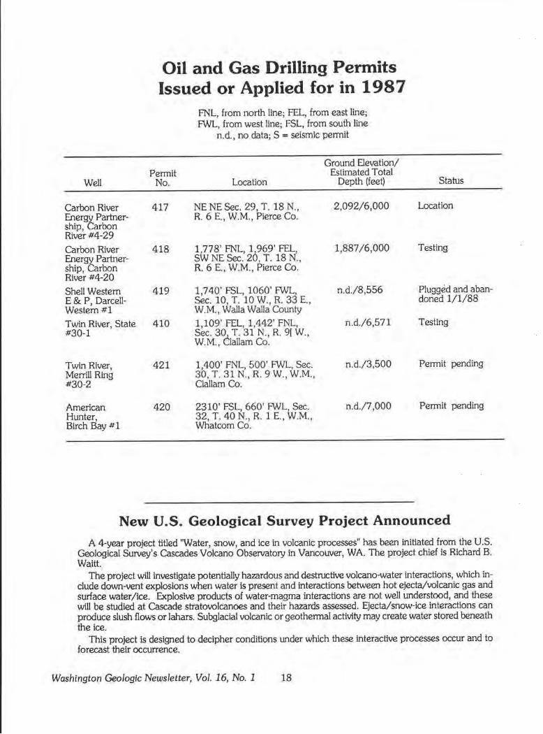
Oil and Gas Drilling Permits Issued or Applied for in 1987
FNL, from north line; FEL, from east line; FWL, from west line; FSL, from south line
n.d., no data; S = seismic permit
Ground Elevation/ Permit Estimated Total
Well No. Location Depth (feet) Status
Carbon River 417 NENESec. 29, T.18N., 2,092/6,000 Location Energt Partner- R. 6 E., W.M., Pierce Co. ship, arbon River #4-29
Carbon River 418 1,778' FNL, 1,969' FEL, 1,887 /6,000 Testing Energy Partner- SW NE Sec. 20, T. 18 N., ship, Carbon R. 6 E., W.M., Pierce Co. River #4-20
Shell Western 419 1,740' FSL, 1060' FWL, n.d./8,556 Plugged and aban-E & P, Darcell- Sec. 10, T. 10 W., R. 33 E., doned 1/1/88 Westem#l W.M., Walla Walla County
Twin River, State 410 1,109' FEL, 1,442' FNL, n.d./6,571 Testing #30-1 Sec. 30, T. 31 N., R. 9[ W.,
W.M., Clallam Co.
Twin River, 421 1,400' FNL, 500' FWL, Sec. n.d./3,500 Permit pending Merrill Ring 30, T. 31 N., R. 9 W., W.M., #30-2 Clallam Co.
American 420 2310' FSL, 660' FWL, Sec. n.d./7,000 Permit pending Hunter, 32, T. 40 N., R. 1 E., W.M. , Birch Bay #l Whatcom Co.
New U.S. Geological Survey Project Announced
A 4-year project titled 'Water, snow, and ice in volcanic processes" has been initiated from the U.S. Geological Survey's Cascades Volcano Observatory in Vancower, WA. The project chief is Richard B. Waitt.
The project will investigate potentially hazardous and destructive volcano-water interactions, which include down-vent explosions when water is present and interactions between hot ejecta/volcanic gas and surface water/ice. Explosive products of water-magma interactions are not well understood, and these will be studied at Cascade stratovolcanoes and their hazards assessed. Ejecta/snow-ice interactions can produce slush flows or lahars. Subglacial volcanic or geothermal activity may create water stored beneath the ice.
This project is designed to decipher conditions under which these interactive processes occur and to forecast their occurrence.
Washington Geologic Newsletter, Vol. 16, No. 1 18
High-Altitude Photos for Washington State Now Available to Public
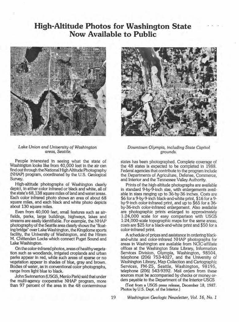
Lake Union and University of Washington areas, Seattle.
People interested in seeing what the state of Washington looks like from 40,000 feet in the air can find out through the National High Altitude Photography (NHAP) program, coordinated by the U.S. Geological Survey.
High-altitude photographs of Washington clearly depict, in either color infrared or black and white, all of the state's 68,138 square miles of land and water areas. Each color infrared photo shows an area of about 68 square miles, and each black and white photo depicts about 130 square miles.
Even from 40,000 feet, small features such as airfields, parks, large buildings, highways, lakes and streams are easily Identifiable. For example, the NHAP photography of the Seattle area clearly shows the "floating bridge" over Lake Washington, the Kingdome sports facility, the University of Washington, and the Hiram M. Chittenden Locks which connect Puget Sound and Lake Washington.
On the color-inf rared photos, areas of healthy vegetation such as woodlands, irrigated croplands and urban parks appear in red, while such areas of sparse or no vegetation appear in shades of blue, gray and brown. Bodies of water, as in conventional color photographs, range from light blue to black.
John Swinnerton (USGS, Menlo Park) said that under the multi-agency cooperative NHAP program, more than 97 percent of the area in the 48 conterminous
19
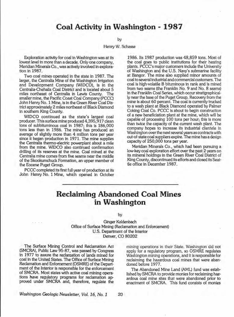
Downtown Olympia, including State Capitol grounds.
states has been photographed. Complete coverage of the 48 states is expected to be completed in 1988. Federal agencies that contribute to the program include the Departments of Agriculture, Defense, Commerce, and Interior and the Tennessee Valley Authority.
Prints of the high-altitude photographs are available in standard 9-by-9-inch siz.e, with enlargements available in siz.es ranging up to 36-by-36 inches. Costs are $6 for a 9-by-9-inch black-and-white prin~ $16 for a 9-by-9-inch color-infrared print, and up to :i,65 for a 36-by-36-inch color-infrared enlargement. Also available are photographic prints enlarged to approximately 1:24,000 scale for easy comparison with USGS 1:24,000-scale topographic maps for the same areas; costs are $25 for a black-and-white print and $50 for a color-infrared print.
A schedule of pric;es and assistance in ordering blackand-white and color-infrared NHAP photographs for areas in Washington are available from NCIC-affiliate offices at the Washington State Library, Information Services Division, Olympia, Washington, 98504, telephone (206) 753-4027, and the University of Washington Library, Map Collection and Cartographic Services, FM-25, Seattle, Washington, 98195, telephone (206) 543-9392. Mail orders from these sources must be accompanied by checks or money orders payable to the Department of the Interlor-USGS
(fext from a USGS press release, December 18, 1987. Photos by U.S. Dept. of the Interior.)
Washington Geologic Newsletter, Vol. 16, No. 1
Coal Activity in Washington - 1987
by
Henry W. Schasse
Exploration activity for coal in Washington was at its lowest level in more than a decade. Only one company, Meridian Minerals Co., was actively involved in exploration in 1987.
Two coal mines operated in the state in 1987. The larger, the Centralia Mine of the Washington Irrigation and Development Company (WIDCO), is in the Centralia-Chehalis Coal District and is located about 5 miles northeast of Centralia in Lewis County. The smaller mine, the Pacific Coast Coal Company (PCCC) John Henry No. 1 Mine, is in the Green River Coal District approximately 2 miles northeast of Black Diamond in southern King County.
WIDCO continued as the state's largest coal producer. This surface mine produced 4,395,917 clean tons of subbituminous coal in 1987; this is 186,000 tons less than in 1986. The mine has produced an average of slightly more than 4 million tons per year since it began production in 1971. The mine supplies the Centralia thermo-electric powerplant about a mile from the mine. WIDCO also continued confirmation drilling of its reserves at the mine. Coal mined at the Centralia mine comes from five seams near the middle of the Skookumchuck Formation, an upper member of the Eocene Puget Group.
PCCC completed its first full year of production at its John Henry No. 1 Mine, which opened in October
1986. Its 1987 production was 48,859 tons. Most of the coal goes to public institutions for their heating plants. PCCC' s major customers include the University of Washington and the U.S. Navy's submarine facility at Bangor. The mine also supplied minor amounts of coal to several industrial and commercial customers. The coal is high-volatile B bituminous in rank and is mined from two seams (the Franklin No. 9 and No. 8 seams) in the Franklin Coal Series, which occur stratigraphically near the base of the Puget Group. Recovery from the mine is about 60 percent. The coal is currently trucked to a wash plant at Black Diamond operated by Palmer Coking Coal Co. PCCC is about to begin construction of a new beneficlation plant at the mine, which will be capable of processing 100 tons per hour; this is more than twice the capacity of the current wash plant. The company hopes to increase its industrial clientele in Washington over the next several years as contracts with out-of-state coal suppliers expire. The mine has a design capacity of 250,000 tons per year.
Meridian Minerals Co., which had been pursuing a low-key coal exploration effort over the past 2 years on its mineral holdings in the Green River Coal District of King County, discontinued its efforts and closed its Seattle office in December 1987.
Reclaiming Abandoned Coal Mines in Washington
by
Ginger Kaldenbach Office of Surface Mining (Reclamation and Enforcement)
U.S. Department of the Interior Denver, CO 80202
The Surface Mining Control and Reclamation Act {SMCRA), Public Law 95-87, was passed by Congress in 1977 to assure the reclamation of lands mined for coal in the United States. The Office of Surface Mining Reclamation and Enforcement {OSMRE) of the Department of the Interior Is responsible for the enforcement of SMCRA. Most states with active coal mining operations have regulatory programs for reclamation approved under SMCRA and, therefore, regulate the
Washington Geologic Newsletter, Vol. 16, No. 1 20
mining operations in their State. Washington did not apply for a regulatory program, so OSMRE regulates Washington mining operations, and it is responsible for reclaiming the hazardous coal mines that were abandoned before 1977.
The Abandoned Mine Land (AML) fund was established by SMCRA to provide monies for reclaiming hazardous coal mine sites that were abandoned prior to enactment of SMCRA. This fund consists of monies
collected from active coal mine operations. Each mine contributes 35 cents per ton for strip-mined coal and 15 cents per ton for underground-mined coal. Washington mining operations have contributed about $16 million to the AML since 1977. AML monies will be collected until 1992, unless Congress rules to continue collection past this date.
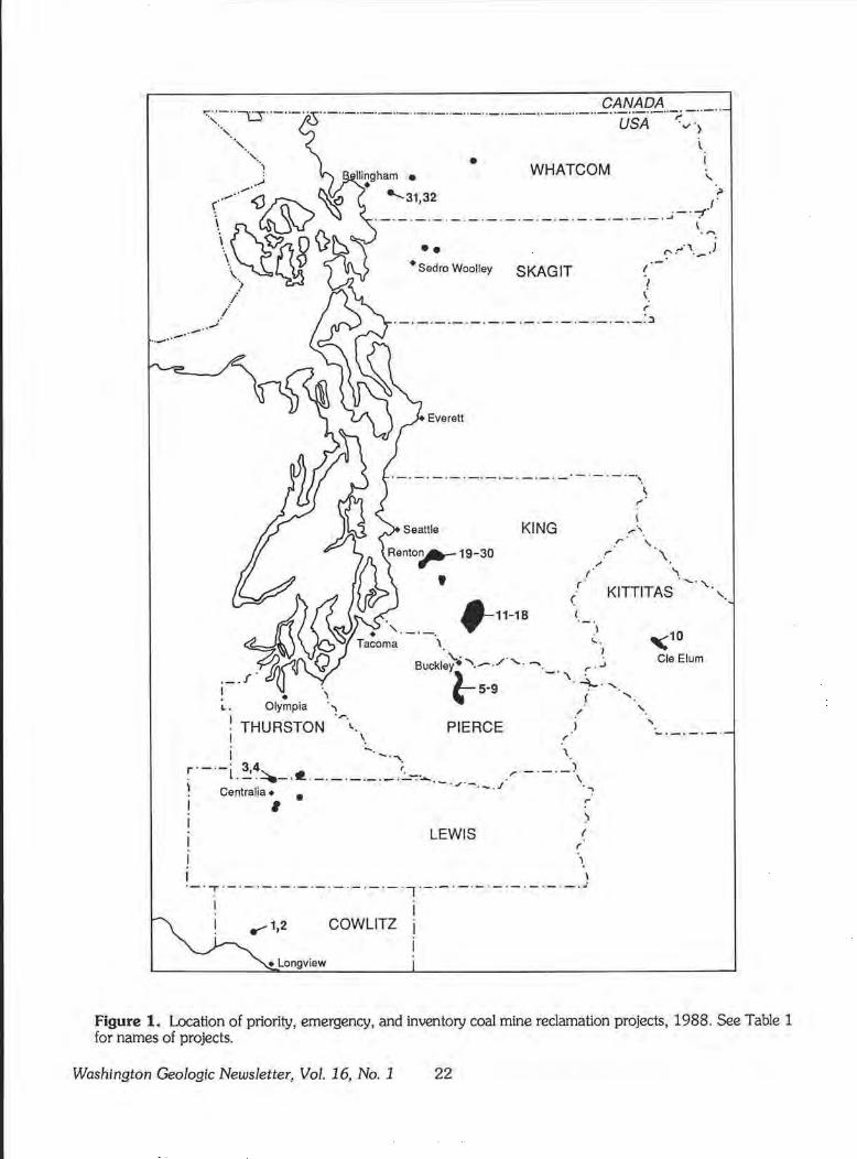
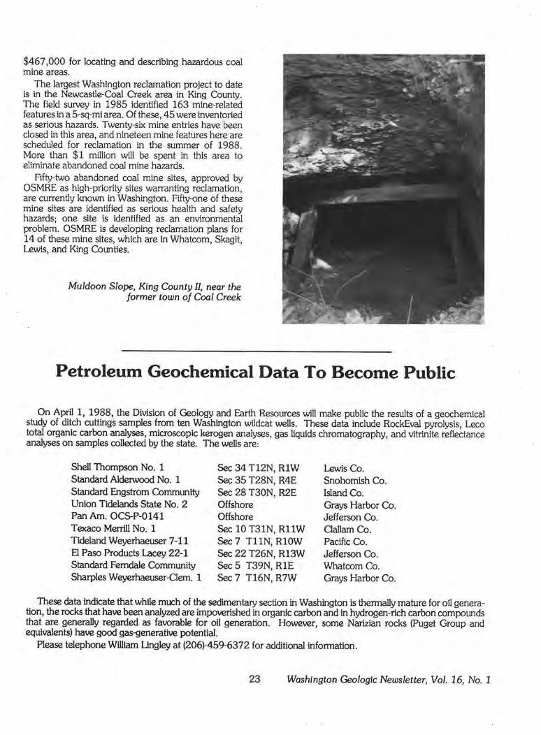
Since 1978, OSMRE has completed 32 reclamation projects in Washington. (See Figure 1 and Table 1.) Nineteen of these were emergency projects, required primarily by the sudden collapse of mine workings or shafts. The total cost of these emergency projects is $297,352. The remaining 13 projects were considered high priority, and $851,054 was expended there. Work at the priority projects primarily involved closing mine entries and shafts; some projects consist of several dozen or more mine features. $466,982 was spent to inventory and evaluate additional coal mine hazards. A total of $1,615,388 has been expended on Washington's abandoned coal mine sites.
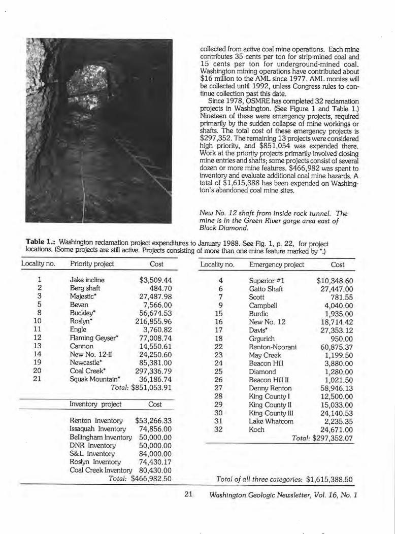
New No. 12 shaft from inside rock tunnel. The mine is in the Green River gorge area east of Black Diamond.
Table 1.: Washington reclamation project expenditures to January 1988. See Fig. 1, p. 22, for project locations. (Some projects are still active. Projects consisting of more than one mine feature marked by • .)
Locality no.
1 2 3 5 8
10 11 12 13 14 19 20 21
Priority project Cost
Jake incline $3,509.44 Berg shaft 484. 7 0 Majestic* 27,487.98 Bevan 7,566.00 Buckley• 56,674.53 Roslyn* 216,855.96 Engle 3,760.82 Flaming Geyser* 77,008.74 Cannon 14,550.61 New No. 12-Il 24,250.60 Newcastle* 85,381.00 Coal Creek* 297,336.79 Squak Mountain* 36,186.74
Total: $851,053.91
Inventory project Cost
Renton Inventory $53,266.33 Issaquah Inventory 74,856.00 Bellingham Inventory 50,000.00 DNR Inventory 50,000.00 S&L Inventory 84,000.00 Roslyn Inventory 74,430.17 Coal Creek Inventory 80,430.00
Total: $466,982.50
Locality no.
4 6 7 9
15 16 17 18 22 23 24 25 26 27 28 29 30 31 32
Emergency project
Superior #l Gatto Shaft Scott Campbell Burdic New No. 12 Davis*
Cost
$10,348.60 27,447.00
781.55 4,040.00 1,935.00
18,714.42 27,353.12
950.00 60,875.37
1,199.50 3,880.00 1,280.00 1,021.50
58,946.13 12,500.00 15,033.00 24,140.53
2,235.35
Grgurich Renton-Noorani May Creek Beacon Hill Diamond Beacon Hill II Denny Renton King County I King County II King County III Lake Whatcom Koch 24,671.00
Total: $297,352.07
Total of all three categories: $1,615,388.50
21 Washington Geologic Newsletter, Vol. 16, No. 1
CANADA ,;;~-"""""\J"_"_"
··,. ··-··-··-··-··-· ·- ··-··-··-··-··-·-··-··-··-··-··-··-··-··-,..;
USA ·v'> l
• WHATCOM t
;,
·-·- ·-·-·- ·- ·- ·- ·-·-·- ·- ·- ·-· - ·-·~- ·-:( .(
•• • Sedro Woolley SKAGIT I
'1 ( r
·-·-·-·-·-·-·- ·- ·- ·- ·- ·- ·-·-·~
Everett
·-·-·-· - ·- ·- ·- ·- ·- ·- ·- ·-· - ·-~
KING
: I
r\ r \.
\ . '"'
r:- :·''·- .J
: \
(
f
r ·
,,,
\ ' · . '\., . 1
" KITTITAS.'-· '·,.
"10 Cle Elum
L • •
Olympia "'
Buckley)~..--./'·--._. '\ ~·J
~5·9 ·t ...... , / '· ·~.
PIERCE I \ !
THURSTON '-. ' I .. - . ..,. \
r·-·-· 34 t ) . L • ....! .,::::._.~ ·-·- ·-·-·-·.:....-::..... . .... - ·-·-\ \ - · .r- ./ . Centralia• • · - · · ~ ! • ,. I > I LEWIS t
(
' I I ·-·:·-·-·-·- ·- ·- ·- ·- ·-·-·, ·-·- ·- ·- ·-·-·-·-·-·~ I .
I , 112 COWLITZ
• Longview
Figure 1. Location of priority, emergency, and inventory coal mine reclamation projects, 1988. See Table 1 for names of projects.
Washington Geologic Newsletter, Vol. 16, No. 1 22
$467,000 for locating and describing hazardous coal mine areas.
The largest Washington reclamation project to date is in the Newcastle-Coal Creek area in King County. The field survey in 1985 identified 163 mine-related features in a 5-sq-mi area. Of these, 45 were inventoried as serious hazards. Twenty-six mine entries have been closed in this area, and nineteen mine features here are scheduled for reclamation in the summer of 1988. More than $1 million will be spent in this area to eliminate abandoned coal mine hazards.
Rfty-two abandoned coal mine sites, approved by OSMRE as high-priority sites warranting reclamation, are currently known in Washington. Fifty-one of these mine sites are identified as serious health and safety hazards; one site is identified as an environmental problem. OSMRE is developing reclamation plans for 14 of these mine sites, which are in Whatcom, Skagit, Lewis, and King Counties.
Muldoon Slope, King County II, near the former town of Coal Creek
Petroleum Geochemical Data To Become Public
On April 1, 1988, the Division of Geology and Earth Resources will make public the results of a geochemical study of ditch cuttings samples from ten Washington wildcat wells. These data include RockEval pyrolysis, Leco total organic carbon analyses, microscopic kerogen analyses, gas liquids chromatography, and vitrinite reflectance analyses on samples collected by the state. The wells are:
Shell Thompson No. 1 Sec 34 T12N, RlW Lewis Co. Standard Alderwood No. 1 Sec 35 T28N, R4E Snohomish Co. Standard Engstrom Community Sec 28 T30N, R2E Island Co. Union Tidelands State No. 2 Offshore Grays Harbor Co. Pan Am. OCS-P-0141 Offshore Jefferson Co. Texaco Merrill No. 1 Sec 10 T31N, RllW Clallam Co. Tideland Weyerhaeuser 7-11 Sec 7 TllN, RlOW Pacific Co. El Paso Products Lacey 22-1 Sec 22 T26N, R13W Jefferson Co. Standard Ferndale Community Sec 5 T39N, RlE Whatcom Co. Sharples Weyerhaeuser-Clem. 1 Sec 7 T16N, R7W Grays Harbor Co.
These data indicate that while much of the sedimentary section in Washington is thermally mature for oil generation, the rocks that have been analyzed are impoverished in organic carbon and in hydrogen-rich carbon compounds that are generally regarded as favorable for oil generation. However, some Narizian rocks (Puget Group and equivalents) have good gas-generative potential.
Please telephone William Lingley at (206)-459-6372 for additional information.
23 Washington Geologic Newsletter, Vol. 16, No. 1
A New Dinosaur for the Burke Museum
by
Keith Kaler
The Burke Museum, located on the University of Washington campus in Seattle is the only place in Washington, Idaho, or Oregon where the public can view a complete dinosaur skeleton. On display is A//osaurus, a late Jurassic meat-eater recovered in Utah. Now the museum is planning to add another well-known type of dinosaur to its dinosaur exhibit-the threehomed plant-eater Triceratops.
Triceratops
The first steps in acqwnng the remains of the Triceratops began in June 1986. Dr. John Rensberger, Curator of Vertebrate Paleontology at the museum, and six student volunteers ventured on a fossil-hunting expedition to eastern Montana. The area had been previously scouted by Dr. Rensberger.
The team could spend only five days that June in the search for fossils, as time and money were at a premium. By the final day the only remains that had been found were scattered fragments of bone. Then, at almost the last hour before the return to Seattle, a skull of a Triceratops was found. Only the rear edge of the frill of the skull was exposed, but this was enough to warrant its excavation. However, until they returned for the next field season, the fossil had to be left in place.
The excavation efforts began in June 1987 and lasted about 8 weeks. The goal was to excavate the skull found the previous summer and to hunt for more fossils. Two students, John Stiller and Greg Erickson, together with Dr. Rensberger, had been members of original discovery team; the rest of the group were new recruits. During the course of this season a second skull was discovered (Fig. 1), excavated, and covered with plaster. The horns of this skull appeared to be in much better condition than those of the first, but it was more difficult to extract. The now plaster-encased and protected skull had to be moved several hundred feet up a 35-degree slope to a waiting van. For 7 hours on one hot day, the crew ratcheted a crude sled carrying the fossil up the slope, a half inch at a time (Fig. 2).
Washington Geologic Newsletter, Vol. 16, No. 1 24
At the end of the field season, both skulls were brought back to Seattle, where they are still undergoing preparation.
Rensberger's objective is to recover and display a complete skeleton of Triceratops. Associated with the skulls were several post-cranial bones- vertebrae and limb fragments- but no major parts of a skeleton. Unexcavated bones were discovered at other sites in the area. Rensberger and his assistants hope these finds will prove to be the tip of the proverbial iceberg. With continued luck, financial support, and time, the paleontologists feel certain that more skeletal remains will be brought back to Seattle permitting an entire Triceratops skeleton to be assembled- and even, perhaps, other dinosaurs as well.
The Burke Museum is responding to the public's everincreasing interest in dinosaurs. One museum event, well on its way to becoming a tradition, is Dinosaur Day. On this day, the museum presents special displays and
Figure 1 .-Burke Museum paleontologists with unexcavated Triceratops skull; broken horn at left arrow, frill at rear of skull at right arrow.
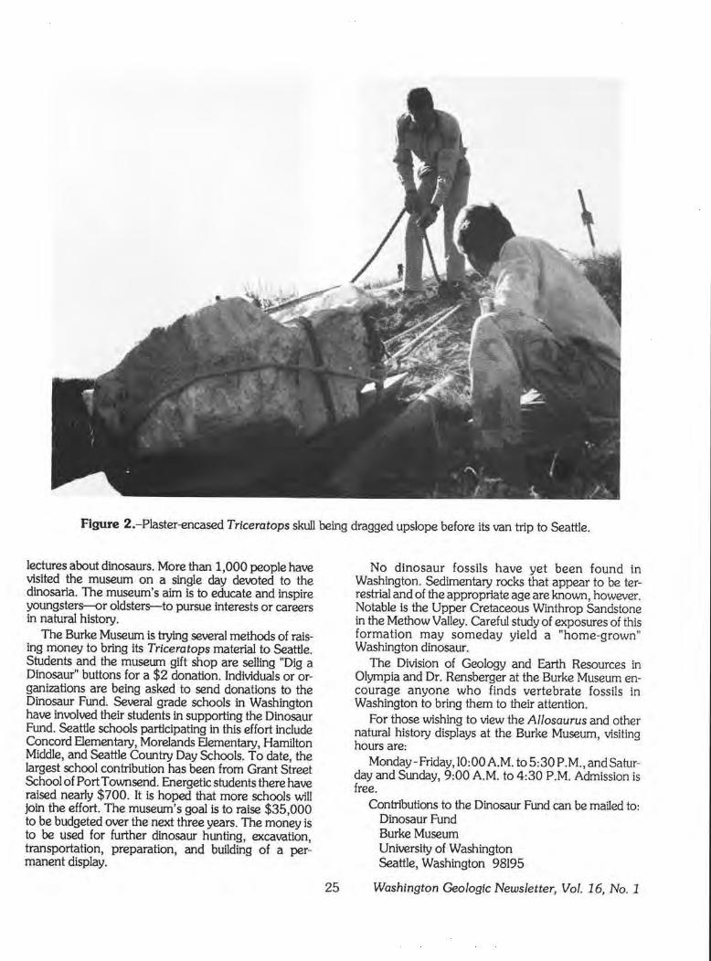
Figure 2.-Plaster-encased Triceratops skull being dragged upslope before its van trip to Seattle.
lectures about dinosaurs. More than 1,000 people have visited the museum on a single day devoted to the dinosaria. The museum's aim is to educate and inspire youngsters-or oldsters--to pursue interests or careers in natural history.
The Burke Museum is trying several methods of raising money to bring its Triceratops material to Seattle. Students and the museum gift shop are selling "Dig a Dinosaur'' buttons for a $2 donation. Individuals or organi1.ations are being asked to send donations to the Dinosaur Fund. Several grade schools in Washington have involved their students in supporting the Dinosaur Fund. Seattle schools participating in this effort include Concord Elementary, Morelands Elementary, Hamilton Middle, and Seattle Country Day Schools. To date, the largest school contribution has been from Grant Street School of Port Townsend. Energetic students there have raised nearly $ 7 00. It is hoped that more schools will join the effort. The museum's goal is to raise $35,000 to be budgeted over the next three years. The money is to be used for further dinosaur hunting, excavation, transportation, preparation, and building of a permanent display.
25
No dinosaur fossils have yet been found in Washington. Sedimentary rocks that appear to be terrestrial and of the appropriate age are known, however. Notable is the Upper Cretaceous Winthrop Sandstone in the Methow Valley. Careful study of exposures of this formation may someday yield a "home-grown" Washington dinosaur.
The Division of Geology and Earth Resources in Olympia and Dr. Rensberger at the Burke Museum encourage anyone who finds vertebrate fossils in Washington to bring them to their attention.
For those wishing to view the Al/osaurus and other natural history displays at the Burke Museum, visiting hours are:
Monday-Friday, 10:00AM. to5:30 P.M., and Saturday and Sunday, 9:00 AM. to 4:30 P.M. Admission is free.
Contributions to the Dinosaur Fund can be mailed to: Dinosaur Fund Burke Museum University of Washington Seattle, Washington 98195
Washington Geologic Newsletter, Vol. 16, No. 1
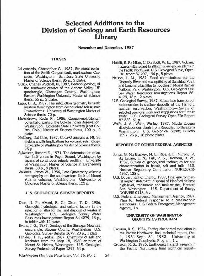
Selected Additions to the Division of Geology and Earth Resources
Library
November and December, 1987
TIIESES
Dileonardo, Christopher G., 1987, Structural evolution of the Smith Canyon fault, northeastern Cascades, Washington: San Jose State University Master of Science thesis, 85 p., 2 plates.
Gulick CharlesWyckoff,III, 1987, Bedrock geology of th~ southwest quarter of the Aeneas Valley 15' quadrangle, Okanogan County, Washington: F.astern Washington University Master of Science thesis, 55 p., 2 plates.
Lapp, D. B., 1987, The subduction geometry beneath western Washington from deconvolved teleseismic P-waveforms: University of Washington Master of Science thesis, 70 p.
McAndrews, Kevin P., 1986, Copper-molybdenum potential of parts of the Colville Indian Reservation, Washington: Colorado State University [Fort Collins, Colo.] Master of Science thesis, 100 p., 4 plates.
McClurg, Dai Cole, 1987, Coda-Q analysis at Mt. St. Helens and its implications for volcanic seismology: University of Washington Master of Science thesis, 75p.
Sylwester, Richard E. , 1971, The determination of active fault zones in Puget Sound, Washington by means of continuous seismic profiling: University of Washington Master of Science in Engineering thesis, 88 p., 9 plates.
Vallance, James W., 1986, Late Quaternary volcanic stratigraphy on the southwestern flank of Mount Adams volcano, Washington: University of Colorado Master of Science thesis, 122 p.
U.S. GEOLOGICAL SURVEY REPORTS
Dion, N. P.; Alvord, R. C.; Olson, T. D., 1986, Geologic, hydrologic, and cultural factors in the selection of sites for the land disposal of wastes in Washington: U.S. Geological Survey Water Resources Investigations Report 84-4279, 16 p., in folder with 12 plates.
Evans, J. G., 1987, Geology of the Stensgar Mountain quadrangle, Stevens County, Washington: U.S. Geological Survey Bulletin 1679, 23 p., 1 plate.
Hinkley, T. K., editor, 1987, Chemistry of ash and leachates from the May 18, 1980 eruption of Mount St. Helens, Washington: U.S. Geological Survey Professional Paper 1397, 64 p.
Washington Geologic Newsletter, Vol. 16, No. 1 26
Hoblitt, R. P.; Miller, C. D.; Scott, W. E., 1987, Volcanic hazards with regard to siting nuclear-power plants in the Pacific Northwest: U.S. Geological Survey OpenFtle Report 87-297, 196 p., 5 plates.
Nelson, L. M., 1987, Flood characteristics for the Nisqually River and susceptibility of Sunshine ~o~nt and Longmire facilities to flooding in Mount Rainier National Park, Washington: U.S. Geological Survey Water Resources Investigations Report 86-4179, 18 p., 2 plates.
U.S. Geological Survey, 1987, Subsurface transport of radionuclides in shallow deposits of the Hanford nuclear reservation, Washington- Review of selected previous work and suggestions for further study: U.S. Geological Survey Open-File Report 87-222, 61 p.
Wolfe, J. A.; Wehr, Wesley, 1987, Middle Eocene dicotyledonous plants from Republic, northeastern Washington: U.S. Geological Survey Bulletin 1597, 25 p., 16 photo plates.
REPORTS OF OTHER FEDERAL AGENCIES
Jones, G. M.; Blackey, M. E.; Rice, J.E.; Murphy, V. J.; Levine, E. N.; Fisk, P. S.; Bromery, R. W., 1987, Survey of geophysical techniques for site characterization in basalt, salt and tuff: U.S. Nuclear Regulatory Commission NUREG/CR-4957, 138 p.
U.S. Department of Energy, 1987, Final environmental impact statement, disposal of Hanford defense high-level, transuranic and tank wastes, Hanford Site, Washington: U.S. Department of Energy DOE/EIS-0113, 5 V.
U.S. Federal Emergency Management Agency, 1987, Plan for federal response to a catastrophic earthquake: U.S. Federal Emergency Management Agency, 1 v.
UNIVERSITY OF WASHINGTON GEOPHYSICS PROGRAM
Crosson, R. S., 1984, Earthquake hazarq evaluation in the Pacific Northwest; final technical report, Oct. 1, 1981-Sept. 31, 1982: University of Washington Geophysics Program, 1 v.
Crosson, R. S., 1986, F.arthquake hazard research in the Pacific Northwest; final technical report--
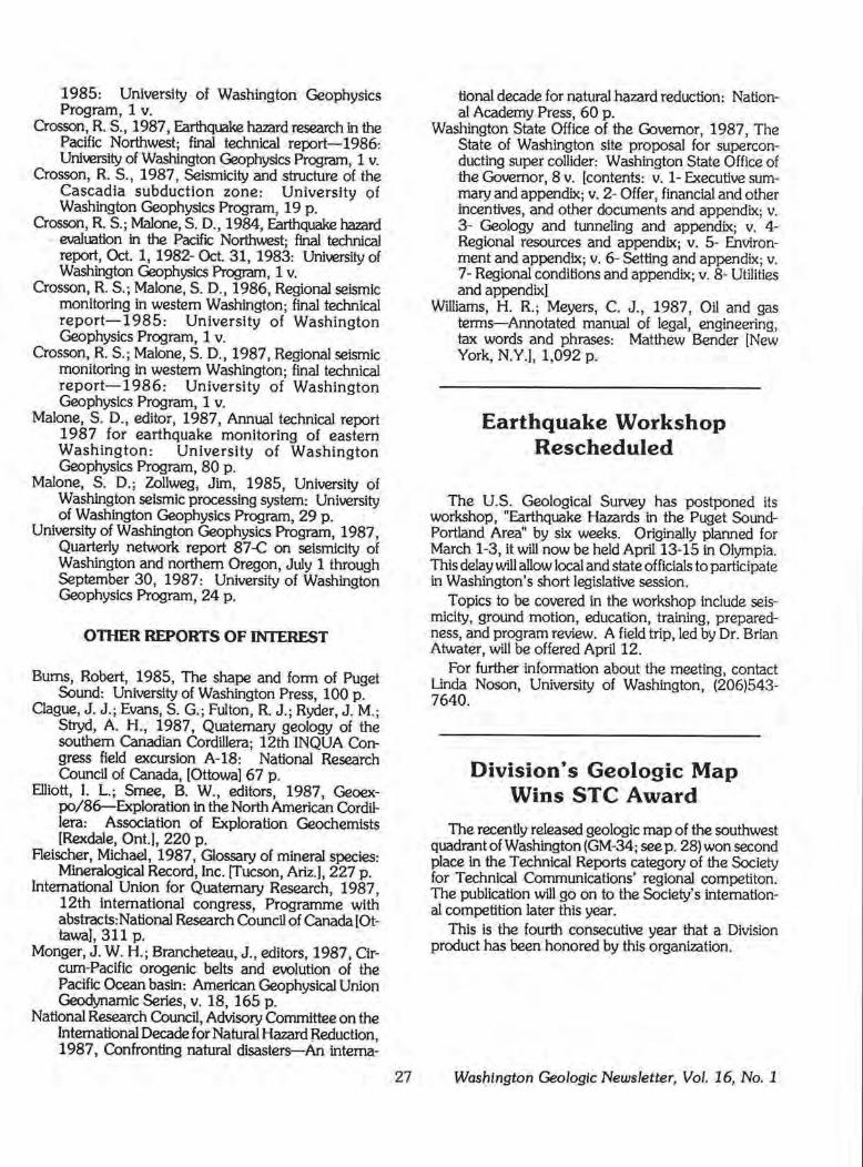
1985: University of Washington Geophysics Program, 1 v.
Crosson, R. S., 1987, Earthquake hazard research in the Pacific Northwest; final technical report-1986: University of Washington Geophysics Program, 1 v.
Crosson, R. S., 1987, Seismicity and structure of the Cascadia subduction zone: University of Washington Geophysics Program, 19 p.
Crosson, R. S.; Malone, S. D., 1984, Earthquake hazard evaluation in the Pacific Northwest; final technical report, Oct. 1, 1982-Oct.31, 1983: University of Washington Geophysics Program, 1 v.
Crosson, R. S.; Malone, S. D., 1986, Regional seismic monitoring in western Washington; final technical report-1985: University of Washington Geophysics Program, 1 v.
Crosson, R. S.; Malone, S. D. , 1987, Regional seismic monitoring in western Washington; final technical report-1986: University of Washington Geophysics Program, 1 v.
Malone, S. D., editor, 1987, Annual technical report 1987 for earthquake monitoring of eastern Washington: University of Washington Geophysics Program, 80 p.
Malone, S. D.; Zollweg, Jim, 1985, University of Washington seismic processing system: University of Washington Geophysics Program, 29 p.
University of Washington Geophysics Program, 1987, Quarterly network report 87-C on selsmicity of Washington and northern Oregon, July 1 through September 30, 1987: University of Washington Geophysics Program, 24 p.
OTHER REPORTS OF INTEREST
Bums, Robert, 1985, The shape and form of Puget Sound: University of Washington Press, 100 p.
Clague, J. J .; Evans, S. G.; Fulton, R. J.; Ryder, J.M.; Stryd, A H., 1987, Quaternary geology of the southern Canadian Cordillera; 12th INQUA Congress field excursion A-18: National Research Council of Canada, [Ottowa) 67 p.
Elliott, I. L.; Smee, B. W., editors, 1987, Geoexpo/86-Exploration in the North American Cordillera: Association of Exploration Geochemists [Rexdale, Ont.), 220 p.
Fleischer, Michael, 1987, Glossary of mineral species: Mineralogical Record, Inc. [Tucson, Ariz.), 227 p .
International Union for Quaternary Research, 1987, 12th international congress, Programme with abstracts:National Research Council of Canada [Ottawa), 311 p.
Monger, J. W. H.; Brancheteau, J., editors, 1987, Circum-Pacific orogenic belts and e\K>lution of the Pacific Ocean basin: American Geophysical Union Geodynamic Series, v. 18, 165 p.
National Research Council, Advisory Committee on the International Decade for Natural Hazard Reduction, 1987, Confronting natural disasters-An intema-
27
tional decade for natural hazard reduction: National Academy Press, 60 p.
Washington State Office of the Governor, 1987, The State of Washington site proposal for superconducting super collider: Washington State Office of the Governor, 8 v. [contents: v. 1- Executive summary and appendix; v. 2- Offer, financial and other incentives, and other documents and appendix; v. 3- Geology and tunneling and appendix; v. 4-Regional resources and appendix; v. 5- Environment and appendix; v. 6- Setting and appendix; v. 7- Regional conditions and appendix; v. 8- Utilities and appendix)
Williams, H. R.; Meyers, C. J., 1987, Oil and gas terms-Annotated manual of legal, engineering, tax words and phrases: Matthew Bender [New York, N.Y.), 1,092 p.
Earthquake Workshop Rescheduled
The U.S. Geological Survey has postponed its workshop, "Earthquake Hazards in the Puget SoundPortland Area" by six weeks. Originally planned for March 1-3, it will now be held April 13-15 in Olympia. This delay will allow local and state officials to participate in Washington's short legislative session.
Topics to be covered in the workshop include seismicity, ground motion, education, training, preparedness, and program review. A field trip, led by Dr. Brian Atwater, will be offered April 12.
For further information about the meeting, contact Linda Noson, University of Washington, (206)543-7640.
Division's Geologic Map Wins STC Award
The recently released geologic map of the southwest quadrant of Washington (GM-34; seep. 28) won second place In the Technical Reports category of the Society for Technical Communications' regional competlton. The publication will go on to the Society's international competition later this year.
This is the fourth consecutive year that a Division product has been honored by this organization.
Washington Geologic Newsletter, Vol. 16, No. 1
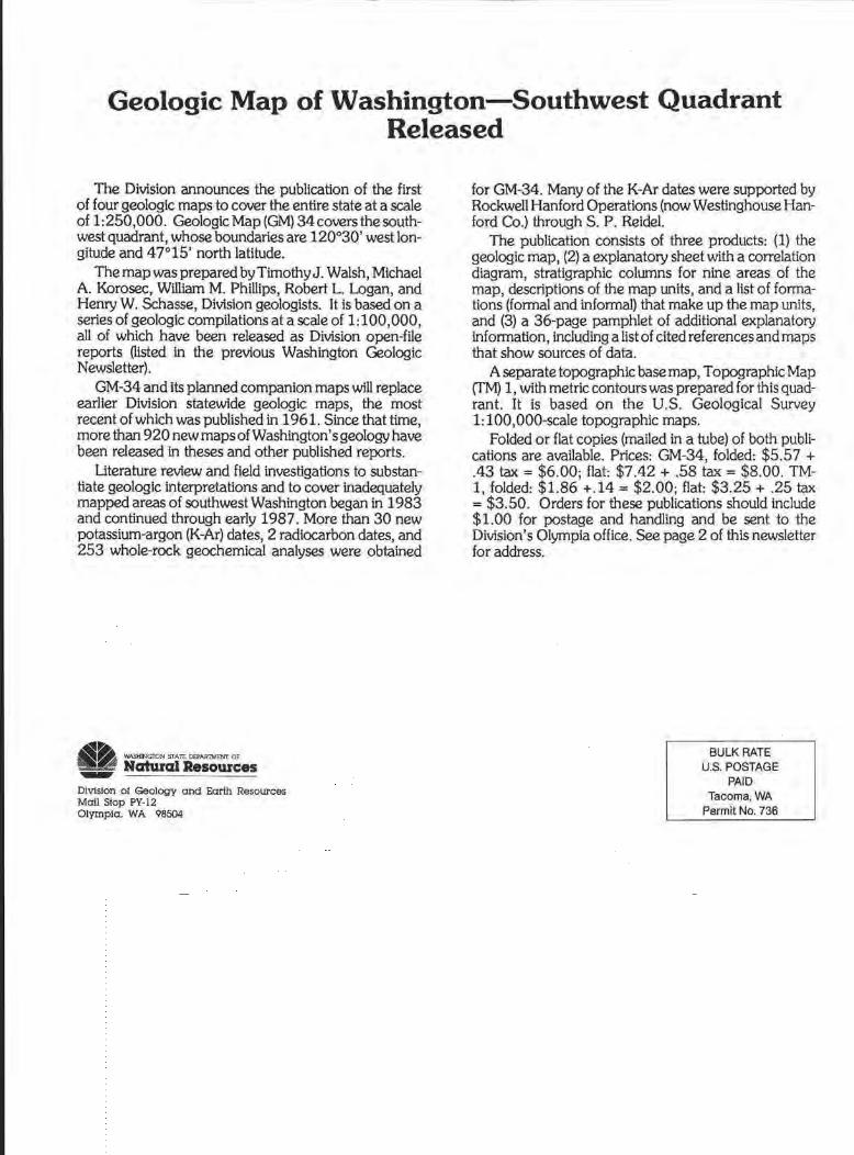
Geologic Map of Washington-Southwest Quadrant Released
The Division announces the publication of the first of four geologic maps to cover the entire state at a scale of 1: 250,000. Geologic Map (GM) 34 covers the southwest quadrant, whose boundaries are 120°30' west longitude and 47°15' north latitude.
The map was prepared by Timothy J. Walsh, Michael A. Korosec, William M. Phillips, Robert L. Logan, and Henry W. Schasse, Division geologists. It is based on a series of geologic compilations at a scale of 1: 100,000, all of which have been released as Division open-file reports Oisted in the previous Washington Geologic Newsletter).
GM-34 and its planned companion maps will replace earlier Division statewide geologic maps, the most recent of which was published in 1961. Since that time, more than 920 new maps of Washington's geology have been released in theses and other published reports.
Literature review and field investigations to substantiate geologic interpretations and to cover inadequately mapped areas of southwest Washington began in 1983 and continued through early 1987. More than 30 new potassium-argon (K-Ar) dates, 2 radiocarbon dates, and 253 whole-rock geochemical analyses were obtained
11~ WASHING'ION STAlt OO'ARTM>NT OF _ Natural Resources
DiVision of Geology and Earth Resources Mail Stop PY-12 Olympia. WA 98504
for GM-34. Many of the K-Ar dates were supported by Rockwell Hanford Operations (now Westinghouse Hanford Co.) through S. P. Reidel.
The publication consists of three products: (1) the geologic map, (2) a explanatory sheet with a correlation diagram, stratigraphic columns for nine areas of the map, descriptions of the map units, and a list of formations (formal and informal) that make up the map units, and (3) a 36-page pamphlet of additional explanatory information, including a list of cited references and maps that show sources of data.
A separate topographic base map, Topographic Map (TM) 1, with metric contours was prepared for this quadrant. It is based on the U.S. Geological Survey 1: 100,000-scale topographic maps.
Folded or flat copies (mailed in a tube) of both publications are available. Prices: GM-34, folded: $5.57 + .43 tax= $6.00; flat: $7.42 + .58 tax= $8.00. TM-1, folded: $1.86 +.14 = $2.00; flat: $3.25 + .25 tax = $3.50. Orders for these publications should include $1.00 for postage and handling and be sent to the Division's Olympia office. See page 2 of this newsletter for address.
BULK RATE U.S. POSTAGE
PAID Tacoma, WA
Permit No. 736