Embed Size (px)
Citation preview
CITY OF BEVERLY HILLS
TRAFFIC & PARKING COMMISSION
July 7, 2016
Traffic & Parking Commission
Aaron Kunz, Deputy Director of TransportationMartha Eros, Transportation Planner
Pedestrian Crossing Evaluation
A. Fehr & Peers MemorandumB. Continental Crosswalk Markings and SignageC. Public Notice
TO:
FROM:
SUBJECT:
ATTACHMENTS:
Introduction
The City retained Fehr & Peers, the City’s on-call traffic engineering firm, to conduct anindependent evaluation of pedestrian crossings at the City. Jaimee Bourgeois of Fehr & Peerswill provide a presentation at the July 7, 2016 Traffic & Parking Commission of theirrecommendations resulting from their study.
Discussion
Fehr & Peers presentation will include two parts:
1. Results of their evaluation and recommendations for crosswalk treatments for sevenlocations in the City as outlines in Attachment A. Staff seeks Commission input andrecommendations regarding prioritization of these crosswalk treatments.
2. Crosswalk treatments at schools. Fehr & Peers conducted research regardingexisting standards and benefits of high visibility “continental” crosswalks and policiesby other local agencies. Based on this evaluation, staff is moving forward withconverting “traditional” crosswalks to “continental” crosswalks beginning in July.
3. Staff is also moving forward with Fehr & Peers’ recommendation to installsupplemental in-street signage at El Rodeo School to remind motorists of the legalrequirement to yield to pedestrians in crosswalks. Attachment B provides examplesof crosswalk markings and proposed in-street signage.
Fehr & Peers is also evaluating crossings along the decomposed granite (DG) path. Staff willforward the results of this evaluation after coordinating with plans for the Beverly GardensMaster Plan and Santa Monica Boulevard Reconstruction Project.
The proposed improvements along Park Way, South Santa Monica Boulevard/Lasky Drive andWilshire Boulevard/South Palm Drive would require preparation of plans, specifications andestimates (PS&E), which is estimated to take 8-10 months to complete after project approval.Following design, the projects would go out for bids and be constructed within roughly a sixmonth time frame.
07.07.16 TPC: Pedestrian Crossing EvaluationPage 2
Public Notice
Notices advising of the Traffic & Parking Commission’s review of pedestrian crosswalks at theJuly 7, 2016 meeting were mailed to the three religious institutions on North Santa MonicaBoulevard; the 500 blocks of North Rodeo, Beverly, Canon and Crescent Drives; the BeverlyHills Unified School District; the General Manager of the Peninsula Hotel; and the propertymanagement companies of the buildings adjacent to the Lasky Drive and South Palm Drivecrosswalks.
Recommendation
That the Traffic & Parking Commission provide input on the Fehr & Peers Evaluation andprovide recommendations regarding prioritization of crosswalk treatments.
m z
FEHRk PEERs
MEMORANDUM
Date: June 30, 2016
To: Aaron Kunz, City of Beverly Hills
From: Rachel Neumann and Jaimee Bourgeois
Subject: Pedestrian Crossing EvaluationRe1 LAI5-2772
This technical memorandum summarizes the results of crosswalk treatment evaluations conducted forseveral existing marked and unmarked crossings at unsignalized intersections in the City of Beverly Hills:the north-south crosswalk across South Santa Monica Boulevard at the intersection with Lasky Drive, thenorth-south crosswalk across Wilshire Boulevard at the intersection with South Palm Drive, the east-weststop-controlled crosswalks across North Rexford Drive in front of City Hall, and the various unmarkedcrosswalks along the south side of Park Way adjacent to Beverly Gardens Park at North Rodeo Drive,North Beverly Drive, North Canon Drive and North Crescent Drive.
The crosswalk evaluations were undertaken to assess the appropriateness of existing or new crossingtreatments given that these crossing locations are at unsignalized intersections along busy arterial streets.All of the evaluations included a site visit, and some also included data collection of 24-hour trafficvolumes, peak hour traffic volumes, pedestrian peak hour volumes, five-year pedestrian collision history.The evaluations are based on guidance provided in the California Manual on Uniform Traffic ControlDevices (CA MUTCD), academic research, national best practices, professional experience, specific siteconditions, and an internal crosswalk treatment identification tool. The tool combines academic researchon crosswalk treatment effectiveness with national best practices and has been peer-reviewed bymembers of the Institute of Transportation Engineer’s Pedestrian and Bicycle Council executivecommittee. Specific roadway conditions considered include speed limit, pedestrian volumes, crossingdistance, number of travel lanes, presence of bicyclists, presence of transit, presence of a median,presence of on-street parking, and expected motorist compliance.
A description of existing conditions and recommended treatment improvements are provided below foreach location separately.
Aaron KunzCity of Beverly HillsJune 30, 2016Page 2
SOUTH SANTA MONICA BOULEVARD & LASKY DRIVE
Existing Conditions
The T-intersection of Lasky Drive with South Santa Monica Boulevard is a side-street stop-controlledintersection located in the City of Beverly Hills immediately west of the major arterial intersection of SantaMonica Boulevard, South Santa Monica Boulevard, and Wilshire Boulevard. South Santa Monica Boulevardprovides two lanes for through traffic in either direction, as well as parking on both sides of the road. Thecurb-to-curb width is 60 feet. The speed limit is 25 miles per hour. At the intersection with Lasky Drive,South Santa Monica Boulevard is divided by a raised median and turning movements from Lasky Drive arelimited to right turns only. A stop-controlled right turn lane from Santa Monica Boulevard onto SouthSanta Monica Boulevard is located almost directly across the raised center median from Lasky Drive,effectively creating a southbound fourth leg to the intersection.
A standard crosswalk extends diagonally north to south across South Santa Monica Boulevardimmediately to the west of the intersection with Lasky Drive. The diagonal nature of the marked crosswalkextends the pedestrian crossing distance across South Santa Monica Boulevard to 85 feet. Pedestrianvisibility is limited on the eastbound approach by parked cars and from the southbound approach by thealignment of the access lane from Santa Monica Boulevard. Existing red curb extends for 20 feet inadvance of the eastbound approach and 15 feet in advance of the westbound approach.
In traffic counts collected on a Tuesday in March, 2016, more than 23,000 daily vehicle trips were recordedon South Santa Monica Boulevard, including almost 1,900 vehicle trips during the morning commute peakhour. Pedestrian volumes were collected during the typical pedestrian peak hour, which occurs in themiddle of the day on a Saturday. Sixty pedestrians were observed using the crosswalk on South SantaMonica Boulevard in the pedestrian peak hour, for an average of one pedestrian per minute.
A five year pedestrian- and bicycle-involved collision review revealed no collisions at or near theintersection between January 2010 and December 2014.
Crosswatk Treatment Options Considered But Rejected
A range of improvements was considered for this location but ultimately rejected as described below:
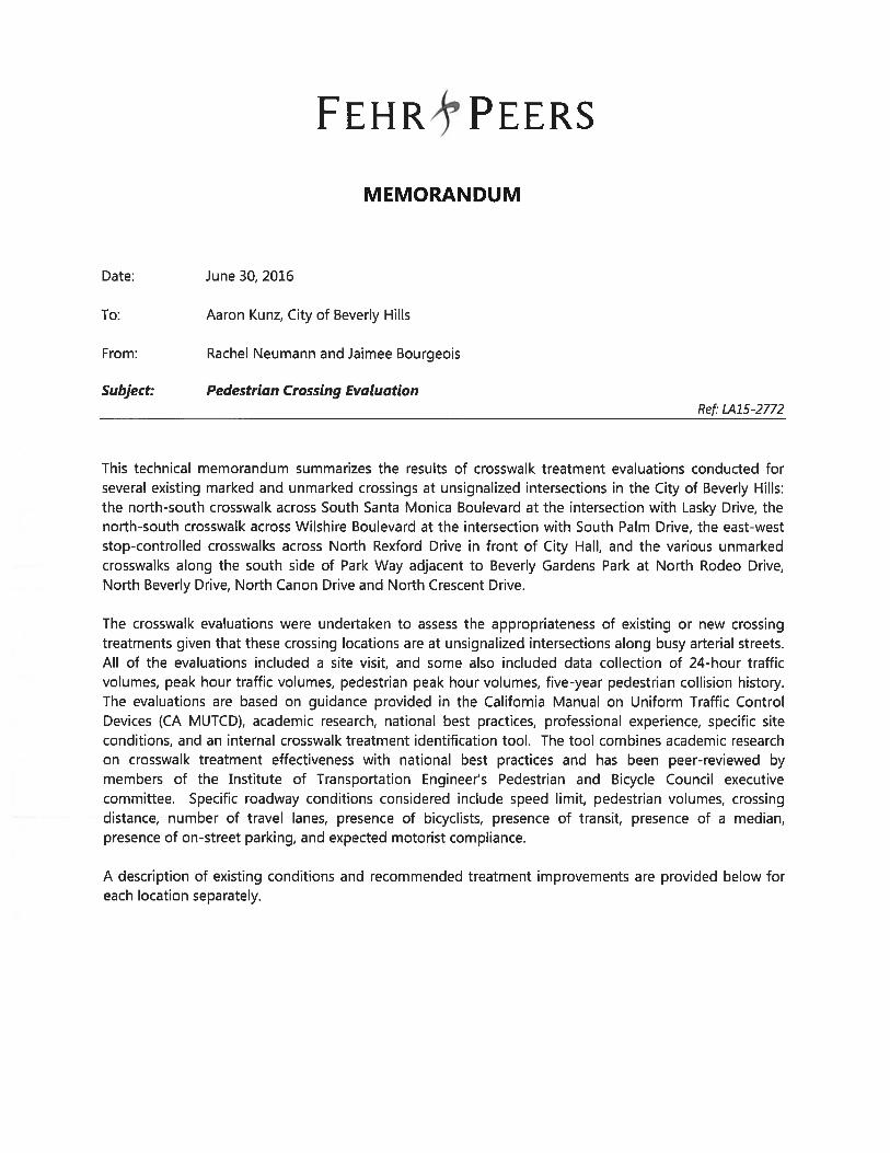
Do Nothing — The combination of high vehicular volume and pedestrian activity results in a largenumber of conflicting movements. The multi-lane configuration further exacerbates thelikelihood of a conflict given the potential for multiple-threat crashes. Multiple-threat crashesoccur when a driver in one lane yields to a pedestrian in a crosswalk, obscuring the pedestrianfrom view of a driver in the adjacent lane, increasing the risk that the vehicle in the other lane willstrike the pedestrian as the pedestrian clears the vehicle in the first lane and steps out in front ofthe second vehicle. Figure 1 illustrates a typical multiple-threat scenario. As such, maintainingthe existing condition is not recommended.
Aaron KunzCity of Beverly HillsJune 30, 2016Page 3 k
• Remove Crosswalk — According to staff, this crosswalk was originally installed in 1962 with thecondition that a crossing guard be provided for the high school. The crossing guard was latermoved to another location but the crosswalk remained. There have been discussions dating backto the late 1960’s about whether to keep the crosswalk at this location. The City’s current TrafficEngineer has advocated for removal of this crosswalkin recent years, so this was examined as anoption. During the weekend peak hour, there were 60 pedestrians counted using this crossing.Activity is likely higher during the peak hour on a weekday given the active, adjacent commercialland use. Legally pedestrians can cross at any location along South Santa Monica Boulevardbetween the signals at Charleville Boulevard and Wilshire Boulevard. This is because there is anintervening unsignalized intersection at Lasky Drive, so crossing the street anywhere betweenCharleville Boulevard and Wilshire Boulevard would not meet the definition of jaywalking asdefined in the California Vehicle Code (Section 21955). As such, removing this crosswalk wouldlikely result in pedestrians still crossing at this location or some other mid-block location nearby.Instead, strategies to increase vehicular-pedestrian separation and enhance motorist awarenesswere further explored. Technologies have advanced significantly since the crosswalk wasoriginally installed, and these technologies have become commonplace as a way of creating morewalkable communities.
• Pedestrian hybrid beacon, or HAWK - A HAWK displays flashing yellow upon pedestrianactuation, followed by steady yellow, followed by steady red, followed by flashing red. It thenreverts to dark until the next actuation. At its shortest distance, the marked crosswalk is less than150 feet to the intersection with Wilshire Boulevard. Eastbound traffic on South Santa MonicaBoulevard waiting to cross Wilshire Boulevard at the signalized intersection frequently queues uppast the intersection with Lasky Drive. Similarly, traffic stopped in the westbound direction by theHAWK could queue back to Wilshire Boulevard. As such, a HAWK signal was not furtherconsidered for this location.
Figure 1. Illustration of multiple-threat crashes.
Aaron KunzCity of Beverly HillsJune 30, 2016Page 4
Recommended Treatment Improvements
kThe recommended improvements for the uncontrolled crossing across South Santa Monica Boulevard atLasky Drive, illustrated in Figure 2 (next page) will maintain existing crosswalk operations withoutimpacting traffic operations at the signalized intersection with Wilshire Boulevard, while providing greatercomfort for pedestrians utilizing the facility, more separation between vehicles and pedestrians, andenhanced warning for motorists approaching the crosswalk. The recommended improvements include thefollowing:
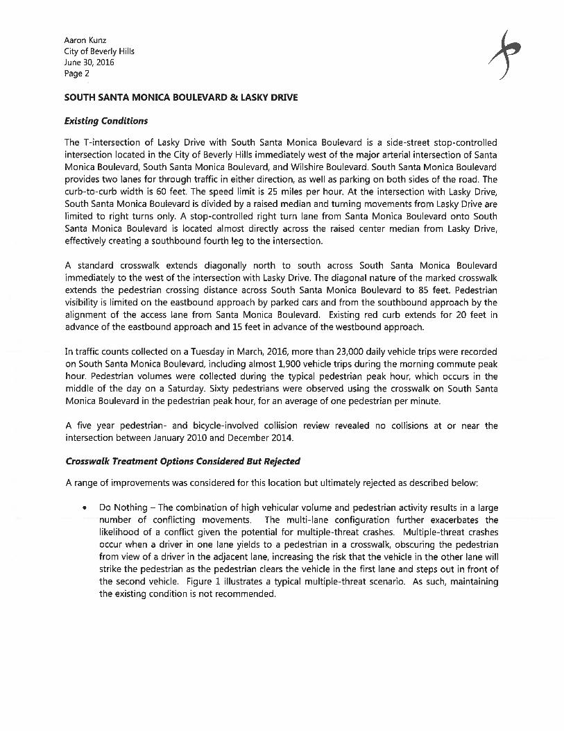
Triple-four high vi5ibitity crosswalk or continentat crosswalk. Crosswalks with the triple-four pattern areso called because an unpainted center channel is bound with high-visibility striped markings on eitherside, with the markings and the center channel forming three 4-foot wide zones. The center channelguides pedestrians along the safest path within the crossing and prevents pedestrians from strayingoutside the crossing. Reflectors placed facing on-coming traffic in each direction of travel provide anadditional alert to drivers about the crosswalk. See Figure 3 for an illustration of a triple-fourcrosswalk. Alternatively, a continental crosswalk can be installed as it provides a similarly high level ofvisibility to the on-coming driver.
Raised median. The crosswalk is bounded on the east side by a narrow raised median. Installation of asmall raised median on the west side of the crosswalk is recommended to provide a pedestrian refugearea in the event that a pedestrian is able to only cross one direction of travel at a time.
Figure 3. Triple-four high visibility crosswalk.
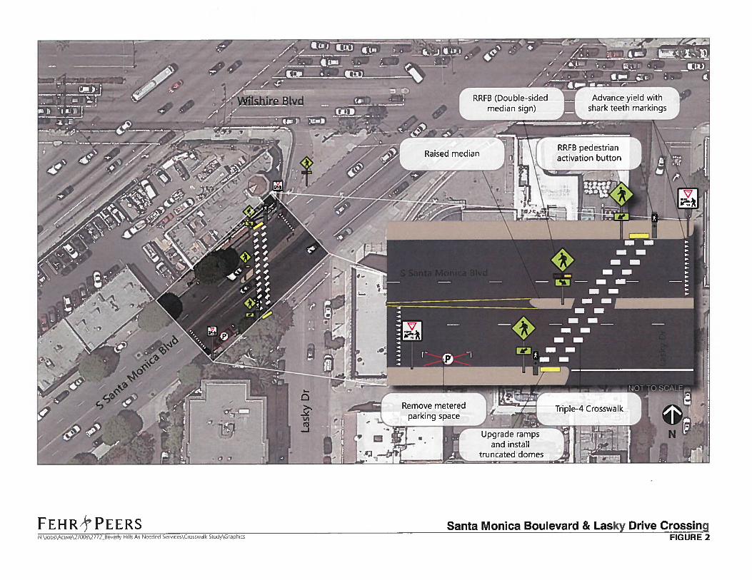
RRFB (Double-sidedmedian sign)
Advance yield withshark teeth markings
RRFB pedestrianactivation button
s. %;,4
FEHR’c’ PEERsN \Jobs\Acsve\27GO\2772 Beverly Hills As Needed Services\Crosswalk Study\Grapbics
Triple-4 Crosswalk
Santa Monica Boulevard & Lasky Drive CrossingFIGURE 2
Raised medianT
Aaron KunzCity of Beverly HillsJune 30, 2016Page 6 k
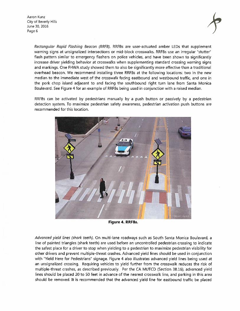
Rectangutar Rapid Ftashing Beacon (RRFB). RRFBs are user-actuated amber LEDs that supplementwarning signs at unsignalized intersections or mid-block crosswalks. RRFBs use an irregular “stutter”flash pattern similar to emergency flashers on police vehicles, and have been shown to significantlyincrease driver yielding behavior at crosswalks when supplementing standard crossing warning signsand markings. One FHWA study showed them to also be significantly more effective than a traditionaloverhead beacon. We recommend installing three RRFBs at the following locations: two in the newmedian to the immediate west of the crosswalk facing eastbound and westbound traffic, and one inthe pork chop island adjacent to and facing the southbound right turn lane from Santa MonicaBoulevard. See Figure 4 for an example of RRFBs being used in conjunction with a raised median.
Advanced yield tines (shark teeth). On multi-lane roadways such as South Santa Monica Boulevard, aline of painted triangles (shark teeth) are used before an uncontrolled pedestrian crossing to indicatethe safest place for a driver to stop when yielding to a pedestrian to maximize pedestrian visibility forother drivers and prevent multiple-threat crashes. Advanced yield lines should be used in conjunctionwith “Yield Here for Pedestrians” signage. Figure 4 also illustrates advanced yield lines being used atan unsignalized crossing. Requiring vehicles to yield further from the crosswalk reduces the risk ofmultiple-threat crashes, as described previously. Per the CA MUTCD (Section 3B.16), advanced yieldlines should be placed 20 to 50 feet in advance of the nearest crosswalk line, and parking in this areashould be removed. It is recommended that the advanced yield line for eastbound traffic be placed
RRFBs can be activated by pedestrians manually by a push button or passively by a pedestriandetection system. To maximize pedestrian safety awareness, pedestrian activation push buttons arerecommended for this location.
Figure 4. RRFBs.
Aaron KunzCity of Beverly HillsJune 30, 2016Page 7
the maximum 50 feet in advance of the crosswalk with adjacent “Yield Here” signage, along with theremoval of one metered parking space. The advanced yield line for the westbound approach shouldbe placed at the minimum recommended 20 feet from the crosswalk in order to also capture thesouthbound right turn lane from Santa Monica Boulevard.
Signage upgrades. Currently, there are roadside pedestrian crosswalk warning signs for bothapproaches. The signage for the westbound approach includes a W54(CA) (pedestrian symbol withcrosswalk lines) with a “PED XING” plaque located beneath on a street light immediately before thecrosswalk. The larger sign is bent and leaning because it extends beyond the sidewalk into theroadway and is likely hit by larger vehicles turning right from the access lane from Santa MonicaBoulevard. The same two signs are in place for the eastbound approach on a street light locatedabout 20 feet before the crosswalk. This combination of signs has been deleted from the CaliforniaManual on Uniform Traffic Control Devices (CA MUTCD) and replaced with the W11-2 (pedestriansymbol without crosswalk lines) and W16-7P (downward pointing arrow). The existing signs shouldbe replaced and upgraded to fluorescent yellow-green for greater conspicuity.
Ramp Upgrades and truncated domes. Truncated domes or tactile warning strips are brightly coloredground surface indicators to assist pedestrians who are blind or visually impaired detect the transitionbetween the sidewalk and the street. The curb is the most reliable cue pedestrians with visionimpairments use to identify this transition. Curb ramps which enhance access for wheelchair userscreate hazards for the visually impaired. A detectable warning at the bottom of the curb ramp canprovide the information pedestrians with visual impairments need to safely cross the street. A 36 inchstrip of detectable warnings should be installed at the bottom of the curb ramp on either approach tothe crosswalk along with curb ramp reconstruction to satisfy other ADA curb ramp requirements, suchas slope limitations and clearance at the top of the ramp.
WILSHIRE BOULEVARD & SOUTH PALM DRIVE
Existing Conditions
The offset intersection of Palm Drive with Wilshire Boulevard is a side-street stop-controlled intersectionlocated in the City of Beverly Hills between the signalized intersections at Rexford Drive and DohenyDrive. Wilshire Boulevard provides three peak-hour travel lanes for through traffic in both directions, andtwo travel lanes with parking on both sides of the road outside of the peak periods. Traffic on WilshireBoulevard at this location is uncontrolled, and the speed limit is 25 miles per hour. The curb-to-curb widthis 68 feet. At the intersection with South Palm Drive, pavement markings create a center median islanddividing Wilshire Boulevard. The north and south legs of Palm Drive, which are stop-controlled, are offsetfrom one another by approximately 100 feet.
A ladder crosswalk extends north to south across Wilshire Boulevard immediately to the west of theintersection with South Palm Drive. The pedestrian crossing distance across Wilshire Boulevard is 68 feet.Pedestrian visibility by approaching motorists is clear due to the straight, flat nature of the roadway at thislocation; however, it may be limited by other moving vehicles during times of heavy traffic flow. Existingred curb extends for 65 feet in advance of the eastbound approach and 32 feet in advance of thewestbound approach.
Aaron KunzCity of Beverly HillsJune 30, 2016Page 8
In traffic counts collected on a Tuesday in March, 2016, more than 47,000 daily vehicle trips were recordedon Wilshire Boulevard, including almost 3,400 vehicle trips during the afternoon commute peak hour.Pedestrian volumes were collected during the typical pedestrian peak hour, which occurs in the middle ofthe day on a Saturday. Twenty pedestrians were observed using the crosswalk on Wilshire Boulevardduring that time period, for an average of one pedestrian every three minutes. Due to the office-orientedland uses near the crosswalk, a higher number of pedestrians might be observed on a weekday.
A five year pedestrian- and bicycle-involved collision review revealed one collision near the intersectionbetween January 2010 and December 2014, when a pedestrian was struck crossing in the unmarkedcrossing at the intersection with North Palm Drive (located 100’ from South Palm Drive).
Crosswalk Treatment Options Considered But Rejected
Do Nothing — The combination of high vehicular volume and pedestrian activity results in a largenumber of conflicting movements. The multi-lane configuration further exacerbates thelikelihood of a conflict given the potential for multiple-threat crashes. Multiple-threat crashesoccur when a driver in one lane yields to a pedestrian in a crosswalk, obscuring the pedestrianfrom view of a driver in the adjacent lane, increasing the risk that the vehicle in the other lane willstrike the pedestrian as the pedestrian clears the vehicle in the first lane and steps out in front ofthe second vehicle. Figure 1 illustrates a typical multiple-threat scenario. As such, maintainingthe existing condition is not recommended.
• Remove Crosswalk — During the weekend peak hour, there were 20 pedestrians counted usingthis crossing. It is expected that activity is higher during the peak hour on a weekday given theadjacent office land use. Removing the marked crosswalk would likely result in pedestrians stillcrossing at this location or some other uncontrolled location nearby since the distance to eitheradjacent signalized crosswalk is about 600 feet. The additional walking distance to cross thestreet by using one of the adjacent controlled, marked crosswalks could be as much as one-quarter mile. It is unrealistic to expect that pedestrians would detour so far out of their way toutilize a controlled, marked crossing and legally pedestrians can cross at any location alongWilshire Boulevard between the signals at North Rexford Drive to the west and North DohenyDrive to the east. Because the crosswalk at South Palm Drive is located almost exactly halfwaybetween the adjacent signalized intersections, it is a good location to channelize pedestrianactivity. As such, strategies to increase vehicular-pedestrian separation and enhance motoristawareness were further explored for this location as well.
• Pedestrian hybrid beacon, or HAWK - A HAWK was also considered at this location but rejected asit would likely interfere with signal coordination along the heavily travelled Wilshire Boulevard.
Aaron KunzCity of Beverly HillsJune 30, 2016Page 9
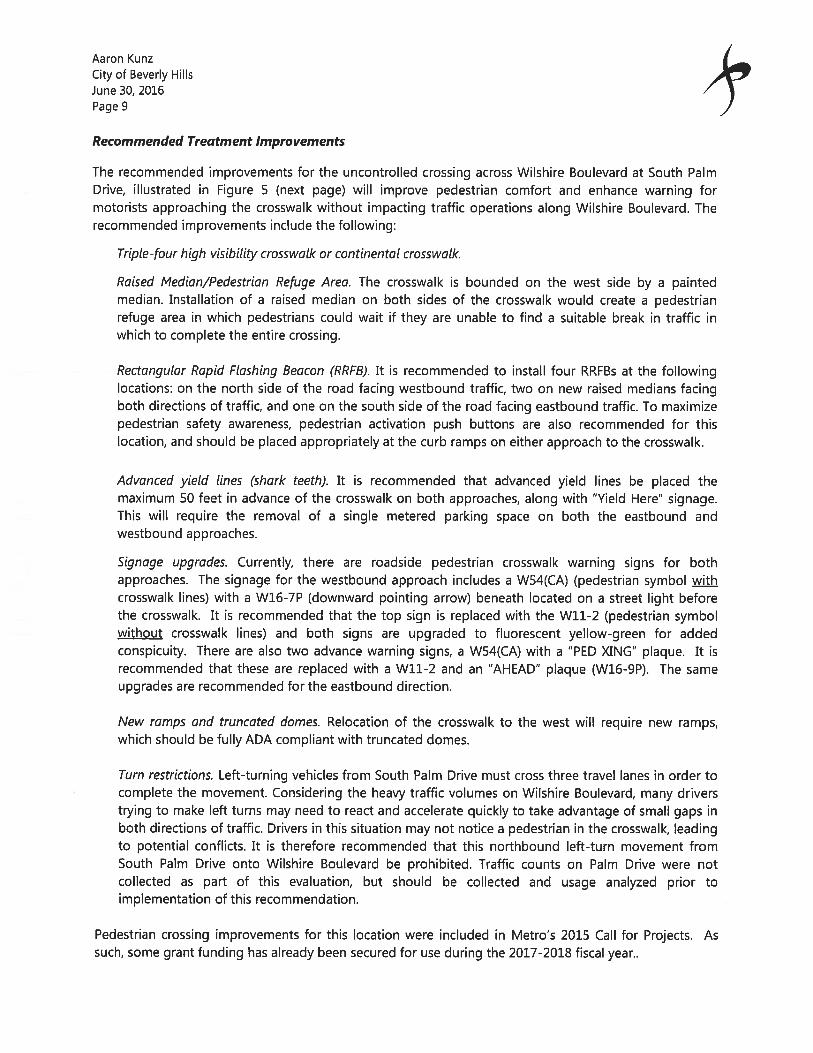
Recommended Treatment Improvements
The recommended improvements for the uncontrolled crossing across Wilshire Boulevard at South PalmDrive, illustrated in Figure 5 (next page) will improve pedestrian comfort and enhance warning formotorists approaching the crosswalk without impacting traffic operations along Wilshire Boulevard. Therecommended improvements include the following:
Triple-four high visibility crosswalk or continentat crosswalk.
Raised Median/Pedestrian Refuge Area. The crosswalk is bounded on the west side by a paintedmedian. Installation of a raised median on both sides of the crosswalk would create a pedestrianrefuge area in which pedestrians could wait if they are unable to find a suitable break in traffic inwhich to complete the entire crossing.
Rectangutar Rapid Ftashing Beacon (RRFB). It is recommended to install four RRFBs at the followinglocations: on the north side of the road facing westbound traffic, two on new raised medians facingboth directions of traffic, and one on the south side of the road facing eastbound traffic. To maximizepedestrian safety awareness, pedestrian activation push buttons are also recommended for thislocation, and should be placed appropriately at the curb ramps on either approach to the crosswalk.
Advanced yield lines (shark teeth). It is recommended that advanced yield lines be placed themaximum 50 feet in advance of the crosswalk on both approaches, along with “Yield Here” signage.This will require the removal of a single metered parking space on both the eastbound andwestbound approaches.
Signage upgrades. Currently, there are roadside pedestrian crosswalk warning signs for bothapproaches. The signage for the westbound approach includes a W54(CA) (pedestrian symbol withcrosswalk lines) with a W16-7P (downward pointing arrow) beneath located on a street light beforethe crosswalk. It is recommended that the top sign is replaced with the W11-2 (pedestrian symbolwithout crosswalk lines) and both signs are upgraded to fluorescent yellow-green for addedconspicuity. There are also two advance warning signs, a W54(CA) with a “PED XING” plaque. It isrecommended that these are replaced with a W11-2 and an “AHEAD” plaque (W16-9P). The sameupgrades are recommended for the eastbound direction.
New ramps and truncated domes. Relocation of the crosswalk to the west will require new ramps,which should be fully ADA compliant with truncated domes.
Turn restrictions. Left-turning vehicles from South Palm Drive must cross three travel lanes in order tocomplete the movement. Considering the heavy traffic volumes on Wilshire Boulevard, many driverstrying to make left turns may need to react and accelerate quickly to take advantage of small gaps inboth directions of traffic. Drivers in this situation may not notice a pedestrian in the crosswalk, leadingto potential conflicts. It is therefore recommended that this northbound left-turn movement fromSouth Patm Drive onto Wilshire Boulevard be prohibited. Traffic counts on Palm Drive were notcollected as part of this evaluation, but should be collected and usage analyzed prior toimplementation of this recommendation.
Pedestrian crossing improvements for this location were included in Metro’s 2015 Call for Projects. Assuch, some grant funding has already been secured for use during the 2017-2018 fiscal year..
Advance yield withshark teeth markings
Raised median
ILU
I-Iire Blvd
Remove 1 meteredparking space
4Triple-4 Crosswalk
Prohibited left turns
FEHRk PEERS Wilshire Boulevard & Palm Drive CrossingFIGURE 5N \iobs\Actve\27OO\2772_BeverIy Hills As Needed Services\Crosswalk StudsGtaphiCS
Aaron KunzCity of Beverly HillsJune 30, 2016Page 11
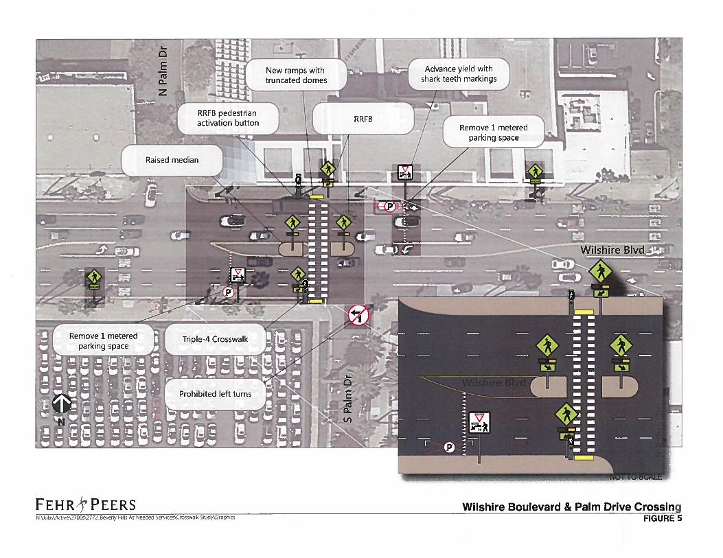
NORTH REXFORD DRIVE AND PARKING GARAGE
Existing Conditions
The intersection of North Rexford Drive with the City Hall parking garage is three-way stop controlled.The intersection underwent reconstruction in 2014 to narrow the garage driveway by removing a circularfeature. This modification also brought the two marked crosswalks across North Rexford Drive closertogether. Each approach is controlled with a STOP sign and STOP pavement legend. While North RexiordDrive provides one lane in each direction, there is an additional left-turn lane on the southboundapproach for access to the garage. Advance limit (stop) lines are provided for each approach set back 4’from the crosswalk to create separation between stopped motorists and pedestrians. In both thenorthbound and southbound directions, signs are provided at the second crossing (far side ofintersection) notifying motorists to yield to pedestrians (Caltrans Ri-S signs). A fire station is located justsouth of the intersection on the west side of North Rexford Drive.
Recommended Treatment Improvements
Our evaluation of this intersection did not include data collection but rather was limited to a site visit,review of existing traffic control and identification of enhancements, if any, that could help increasemotorist compliance with stopping and yielding to pedestrians. During our field investigation, it wasnoted that a majority of trips traveling through the intersection are not associated with City Hall.Motorists appeared to be inpatient due to having to wait in the queue to pass through the intersection.While the majority of vehicles were observed coming to a complete stop and yielding to pedestrians,some were observed rolling through the stop and not properly yielding to pedestrians.
According to the CA MUTCD in Section 2B.ii, the yield to pedestrians sign (Ri-5) shall be used whenyield lines are used in advance of a marked crosswalk that crosses an uncontrolled multi-lane approach.There are no other applications specified in the CA MUTCD for the use of this sign. Therefore, werecommend replacing existing signage with a pedestrian crossing (Wli-2) warning sign, supplementedwith a diagonal arrow (W16-7), post mounted with a seven foot clearance to more conspicuously warnmotorists of the presence of pedestrians.
The CA MUTCD provides an option in Section 2B.i2 to place In-Street Pedestrian Crossing signs (R1-6) atunsignalized pedestrian crosswalks to remind users of laws pertaining to right-of-way. When used, thesesigns are recommended to be placed in the roadway at the crosswalk location on the center line, on alane line, or on a median island.
Figure 6 shows the study location and the recommended placement of the aforementioned signs.Staff hasalready ordered the recommended in-street signs.
Aaron KunzCity of Beverly HillsJune 30, 2016Page 12
PARK WAY AT BEVERLY GARDENS PARK
k
In response to concerns for pedestrian safety on North Rodeo Drive communicated by representatives ofthe Beverly Hills Presbyterian Church, City staff asked for an evaluation of whether a marked crosswalkwould be appropriate across North Rodeo Drive at Park Way. Based on initial field observations and thelevel of pedestrian activity at this location as well as the intersections to the east along Beverly GardensPark, it was recommended that the review be expanded to include North Beverly Drive, North Canon Driveand North Crescent Drive.
Existing Conditions
Park Way functions as an alley west of North Rodeo Drive and east of North Crescent Drive. BetweenNorth Rodeo Drive and North Crescent Drive, including intersections with North Beverly Drive and NorthCanon Drive, it is a two lane roadway adjacent to and north of Beverly Gardens Park with angled, meteredparking on the south side and parallel parking on the north side. Park Way is considered the side streetand is stop controlled at each of these four intersections. All four of the major streets are uncontrolled.Although there are no marked crosswalks along Park Way to cross the major streets at these fourintersections, pedestrians can legally cross the street at any intersection per the California Vehicle Codeunless posted otherwise. The only location with crossing prohibition signage is on the south side of ParkWay at North Rodeo Drive. The signs direct pedestrians to use the signalized crossing at the Santa
1
____
Figure 6. North Rexford Drive Signage Recommendations
Aaron KunzCity of Beverly HillsJune 30, 2016Page 13
Monica Boulevard traffic signal. Despite this signage, there are many pedestrians observed crossing atthis location.
Vehicle and pedestrian counts were collected to quantify the level of activity at these locations. Data onpedestrian activity was collected across multiple high-activity periods, including the pedestrian peak houras identified in the Southern California Council of Governments Bicycle Count Training Manual (Saturdaysfrom 12:00 — 2:00 PM), on Sunday mornings between services at the adjacent Beverly Hills PresbyterianChurch (Sundays from 9:30 — 11:30 AM), and on weekday mornings during the church’s preschool drop-off time (Tuesdays from 8:00 — 10:00 AM). Following data collection, we then applied our internalcrosswalk tool and completed a site visit to conduct a context sensitive analysis.
The peak hour north/south vehicle volume on Rodeo Drive was identified as 673 vehicles. Pedestriancounts were collected across a range of high-level pedestrian activity times on a weekday morning, aSaturday afternoon, and a Sunday mid-morning. During the heaviest one-hour peak (occurring Sundaymorning), 85 pedestrians crossed in the east/west direction. Of the 85 pedestrians who crossed east/west,25 — almost 30% — crossed away from the intersection, mid-block between Park Way and Santa MonicaBoulevard. The remaining 60 pedestrians crossed at the intersection. Interestingly, 23 of those crossingsoccurred on the south side of the intersection where crossings are prohibited. There were only fourbicycles counted during the entire period, one traveling east along Park Way, and three traveling south onRodeo Drive.
The peak hour north/south vehicle volume on Beverly Drive was identified as 1,121 vehicles. Pedestriancounts were collected on a Saturday afternoon and a Sunday mid-morning. During the heaviest one-hourpeak (occurring Sunday morning), 49 pedestrians crossed in the east/west direction. Of the 49pedestrians who crossed east/west, five crossed away from the intersection, mid-block between Park Wayand Santa Monica Boulevard. The remaining 44 pedestrians crossed at the intersection. There were onlynine bicycles counted during the entire period, one traveling east along Park Way, and eight travelingnorth or south on Beverly Drive.
The peak hour north/south vehicle volume on Canon Drive was identified as 960 vehicles. Pedestriancounts were collected on a Saturday afternoon and a Sunday mid-morning. During the heaviest one-hourpeak (occurring Saturday afternoon), 124 pedestrians crossed in the east/west direction. Of the 124pedestrians who crossed east/west, 33 — more than a quarter — crossed away from the intersection, mid-block between Park Way and Santa Monica Boulevard. The remaining 91 pedestrians crossed at theintersection. There were only six bicycles counted during the entire period, five traveling east or westalong Park Way, and one traveling north on Canon Drive.
The peak hour north/south vehicle volume on Crescent Drive was identified as 903 vehicles. Pedestriancounts were collected on a Saturday afternoon and a Sunday mid-morning. During the heaviest one-hourpeak (occurring Sunday morning), 22 pedestrians crossed in the east/west direction. Of the 22pedestrians who crossed east/west, 12 — more than half — crossed away from the intersection, mid-blockbetween Park Way and Santa Monica Boulevard. The remaining 11 pedestrians crossed at theintersection. There were only 11 bicycles counted during the entire period, five traveling east or westalong Park Way, and six traveling north or south on Crescent Drive.
Aaron KunzCity of Beverly HillsJune 30, 2016Page 14
Wallis Annenberg Center for the Performing Arts was contacted to determine whether some of thepedestrian activity could be related to patrons parking in the area and walking to the Center. There wereshows on the Saturday and Sunday of data collection, and the first show time was noon each day. Thepeak hour of pedestrian activity occurred Sunday morning at Rodeo Drive, Beverly Drive and CrescentDrive and was likely more influenced by activity associated with the Presbyterian Church and BeverlyGardens Park visitors. The peak hour of pedestrian activity at Canon Drive occurred Saturday afternoon at12:45-1:45 PM. Due to its close proximity to the Center and higher pedestrian volume in comparison tothe other locations, this peak may reflect more activity associated with the Center; however, the Sundaymorning volume at this location was also higher than the other locations.
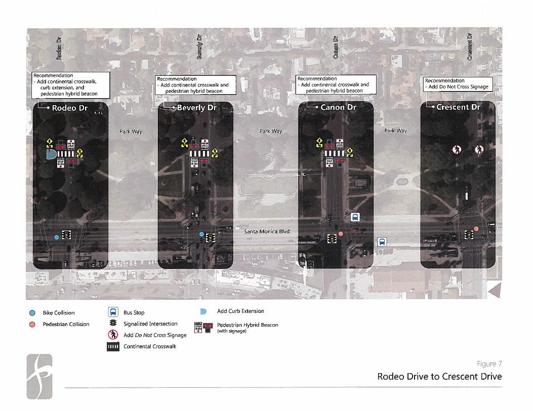
Recommended Treatment Improvements
Along each of the four major streets, the side-street stop-controlled intersection with Park Way isapproximately 250 feet north of each signalized intersection with Santa Monica Boulevard. A markedcrosswalk is recommended at a location near a pedestrian generator and within 300 feet of an existingcrosswalk only if over 40 pedestrians use the crossing per hour. While the intersection with Park Way isless than 300 feet from the intersection with Santa Monica Boulevard, pedestrian volumes are highenough to warrant marked pedestrian crossings at Rodeo Drive, Beverly Drive and Canon Drive. Thepedestrians observed crossing east to west, whether at Park Way or mid-block, were likely park-goersutilizing the grounds and sights within Beverly Gardens Park and crossing east/west to continue their parksojourn along pre-established park paths, or were congregants of Beverly Hills Presbyterian Churchseeking the shortest route to the public parking spaces along Park Way north of Beverly Gardens Park.Some may also be associated with the Center for Performing Arts when shows are happening.
Given the high pedestrian activity at Rodeo Drive, Beverly Drive, and Canon Drive, a marked crosswalkwith high level safety enhancements are recommended, including a pedestrian hybrid beacon and acontinental crosswalk along the south leg of each intersection. The fact that a large number of crossingstake place across Rodeo Drive where there is currently crossing prohibition signagedemonstrates thedemand for crossing at this location. An additional feature recommended at Rodeo Drive is a curbextension (or bulb-out) on the west side of the street to improve visibility associated with the curvature inthe roadway, on-street parking and a large tree immediately north of where the crosswalk would belocated. Removal or relocation of one accessible parking stall would also be needed.
A pedestrian hybrid beacon provides for a protected crossing similar to a traditional traffic signal. Thevehicle indications are dark when no pedestrians are present. Upon arrival, the pedestian would see anUpraised Hand (symbolizing don’t walk) pedestrian indication. The pedestrian would press a push buttonsimilar to a traditional traffic signal to alert the signal control equipment that there is demand for acrossing. The vehicle signal would then display flashing yellow, followed by steady yellow, followed bysteady red. Concurrent with the steady red vehicular indication, the pedestrian indication would changeto a Walking Person (symbolizing walk). After a pre-determined number of seconds, the pedestrianindication would change to a flashing Upraised Hand (symbolizing do not start crossing) and the vehicleindication would change to flashing red, which means that after coming to a stop vehicles may proceedwith caution. The signal indication then reverts back to dark until the next actuation. A benefit of thistype of control is that pedestrians cannot cross at any time resulting in a continuous interruption to trafficflow as they can do today but rather are grouped together. Furthermore, the system can be designed tocommunicate and coordinate with the adjacent signal to stop traffic at preferred times.
Aaron KunzCity of Beverly HillsJune 30, 2016Page 15
The CA MUTCD Section 4F.02 — Guidance, Part A recommends that pedestrian hybrid beacons be installedat least 100 feet from side streets or driveways controlled by stop or yield signage. However, recentstudies conducted by TTI and the City of Tucson, Arizona determined that pedestrian hybrid beaconsplaced at minor intersections or major driveways were successful at reducing pedestrian-involvedcollisions. The CA MUTCD guidance was developed prior to publication of these studies. Additionally, theCA MUTCD statement regarding pedestrian hybrid beacon placement is guidance (“should”) and not arequirement (“shall”). Thus, engineering judgment is permitted for interpretation and, at these locations, apedestrian hybrid beacon is most appropriate.
Due to the lower volumes observed on Crescent Drive (22 during the peak hour) as well as its location atthe terminus of Beverly Gardens Park with no path continuation on the east side, a marked crosswalk isnot recommended at this location. Instead, crossing prohibition signage is recommended directingpedestrians to the signalized crossing at Santa Monica Boulevard.
All of the recommended improvements along Park Way are illustrated on Figure 7.
ii
Park Way
I
• Bike Collision
Pedestrian Collision
Santa Monica Blvd
Add Curb Extension
Pedestrian Hybrid Beacon...‘ (with signage)
Continental Crosswalk
Figure 7
Rodeo Drive to Crescent Drive
Recommendation- Add continental crosswalk,
curb extension, andpedestrian hybrid beacon
Recommendation- Add continental crosswalk and
pedestrian hybrid beacon
Recommendation Recommendation- Add continental crosswalk and
- Add Do Not Cross Signagepedestrian hybrid beacon
Park Way
Bus Stop
§ Signalized Intersection
Add Do Not Cross Signage
m z w
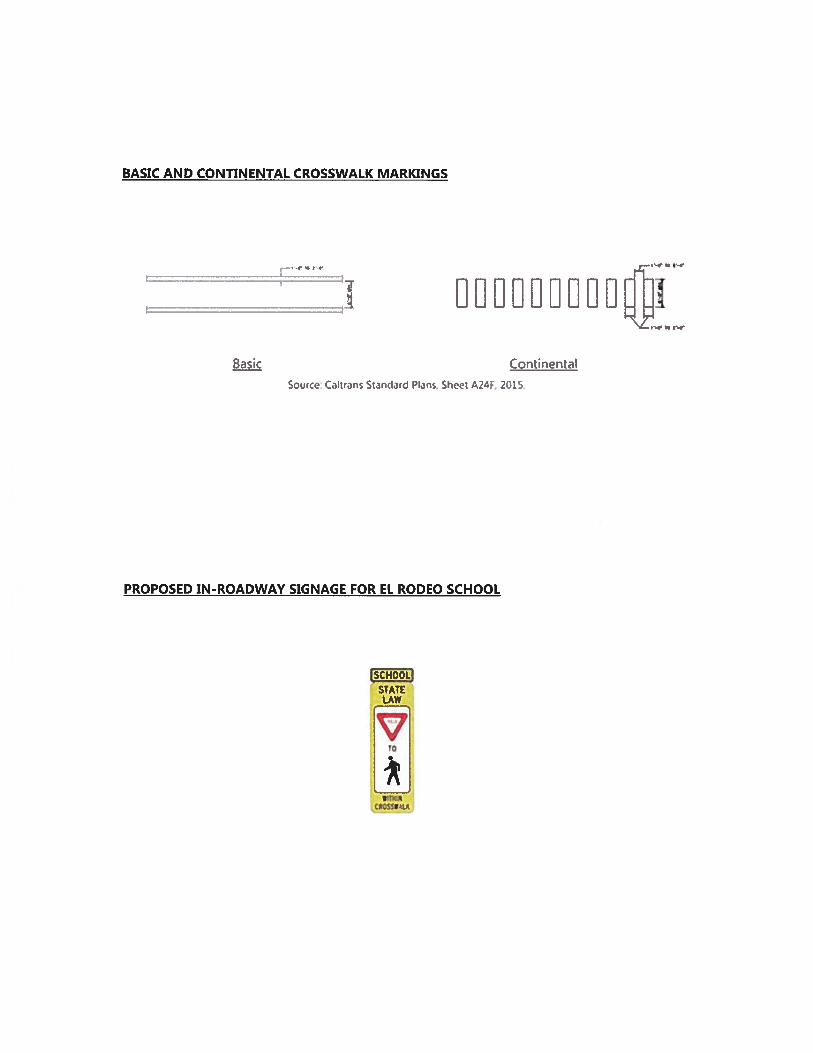
BASIC AND CONTINENTAL CROSSWALK MARKINGS
Basic Continental
Source Caitans Standard Plans, Sheet A24F, 2015.
PROPOSED IN-ROADWAY SIGNAGE FOR EL RODEO SCHOOL
ISCHOOLISTATE
*
ATTACHMENT C
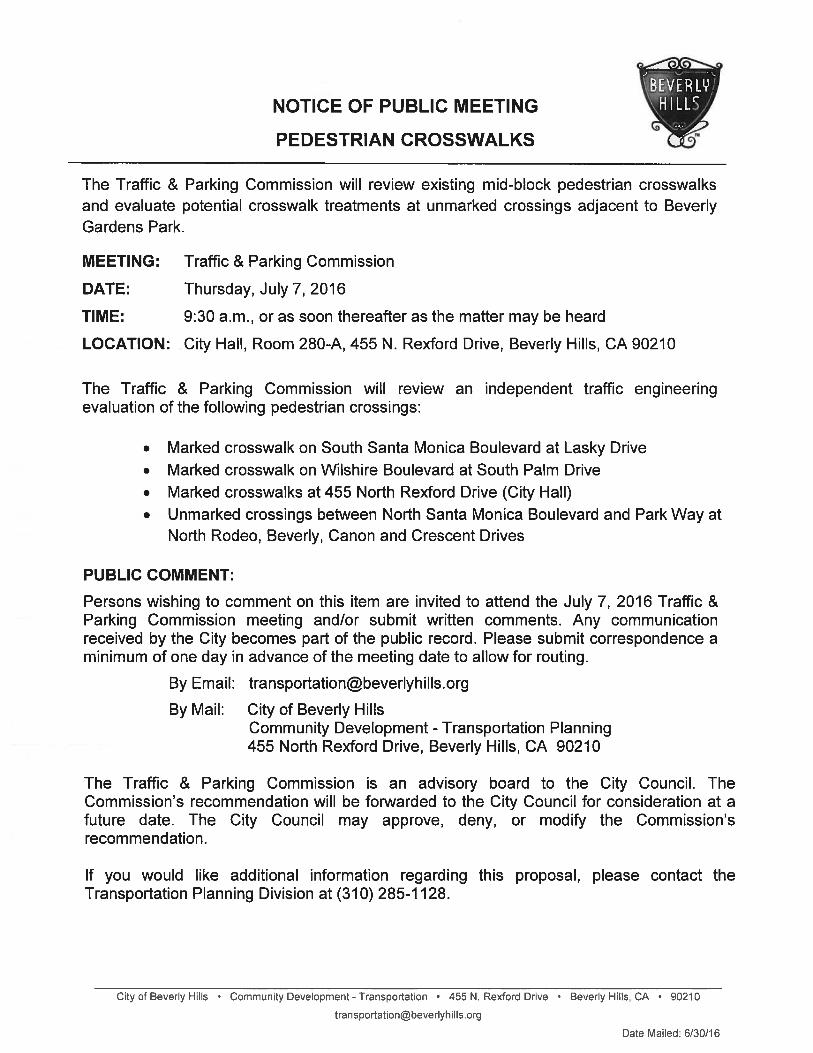
NOTICE OF PUBLIC MEETING
PEDESTRIAN CROSSWALKS
Gardens Park.
MEETING: Traffic & Parking Commission
Thursday, July 7, 2016
9:30 a.m., or as soon thereafter as the matter may be heard
. Marked crosswalk on Wilshire Boulevard at South Palm Drive
. Marked crosswalks at 455 North Rexford Drive (City Hall)
PUBLIC COMMENT:
\HILLS /‘—p
The Traffic & Parking Commission will review existing mid-block pedestrian crosswalksand evaluate potential crosswalk treatments at unmarked crossings adjacent to Beverly
LOCATION: City Hall, Room 280-A, 455 N. Rexford Drive, Beverly Hills, CA 90210
The Traffic & Parking Commission will review an independent traffic engineeringevaluation of the following pedestrian crossings:
• Marked crosswalk on South Santa Monica Boulevard at Lasky Drive
• Unmarked crossings between North Santa Monica Boulevard and Park Way atNorth Rodeo, Beverly, Canon and Crescent Drives
Persons wishing to comment on this item are invited to attend the July 7, 2016 Traffic &Parking Commission meeting and/or submit written comments. Any communicationreceived by the City becomes part of the public record. Please submit correspondence aminimum of one day in advance of the meeting date to allow for routing.
The Traffic & Parking Commission is an advisory board to the City Council. TheCommission’s recommendation will be forwarded to the City Council for consideration at afuture date. The City Council may approve, deny, or modify the Commission’srecommendation.
If you would like additional information regarding this proposal, please contact theTransportation Planning Division at (310) 285-1128.
City of Beverly Hills • Community Development-Transportation 455 N. Rexford Drive • Beverly Hills, CA 90210
Date Mailed: 6/30/16
By Email: transportationbeverIyhiIIs.org
By Mail: City of Beverly HillsCommunity Development - Transportation Planning455 North Rexford Drive, Beverly Hills, CA 90210
DATE:
TIME: