Embed Size (px)
Citation preview
National Aeronautics and Space Administration
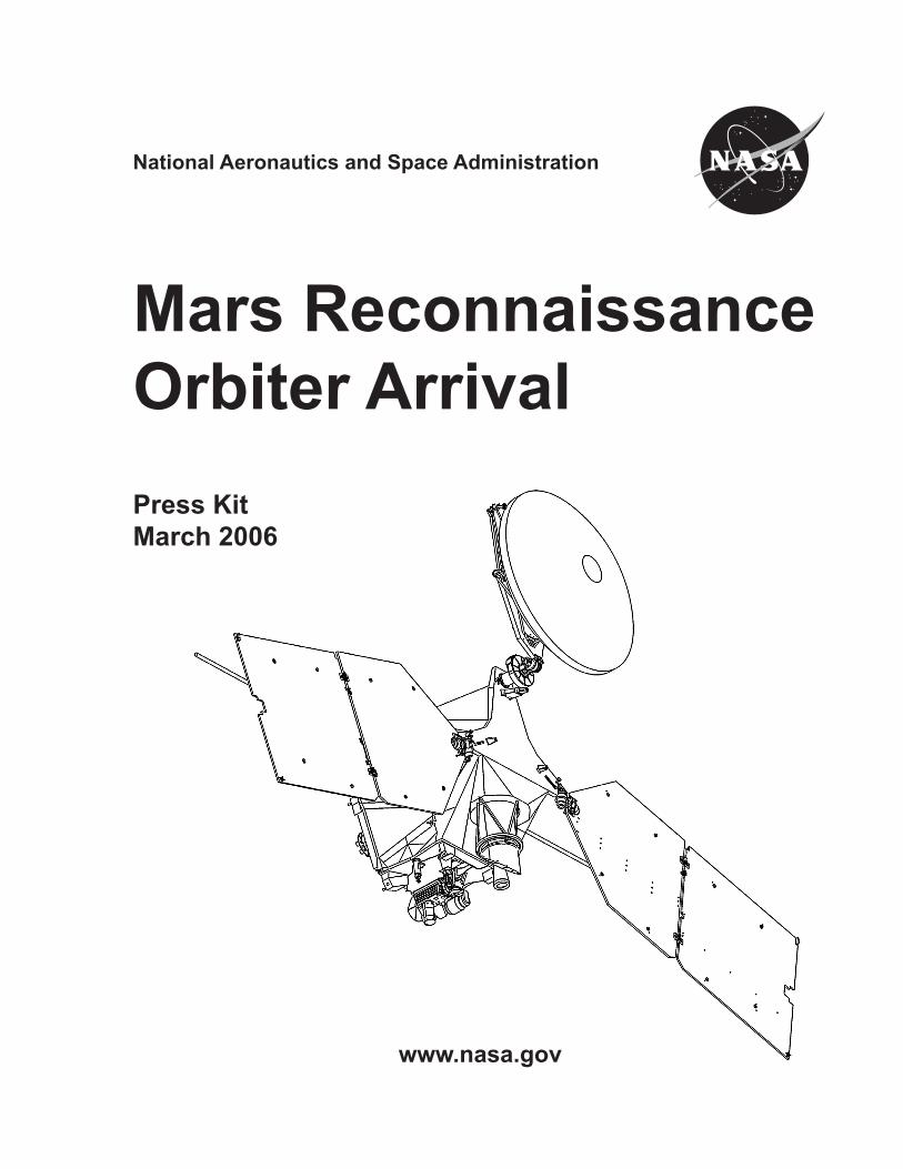
Mars ReconnaissanceOrbiter ArrivalPress KitMarch 2006
www.nasa.gov

�
�
Media Contacts
Dwayne Brown NASA’s Mars Program (�0�) �58-17�6Headquarters [email protected], D.C.
Guy Webster Mars Reconnaissance Orbiter Mission (818) �54-5011Jet Propulsion Laboratory, [email protected], Calif.
Gary Napier Spacecraft & Launch Vehicle (�0�) 971-401�Lockheed Martin Space Systems [email protected], Colo.
Contents
General Release .................................………………………..........................................…........ 5Media Services Information ………………………………………..........................................…...... 7Quick Facts ………………………………………………………................................….…….......… 8Mars at a Glance ………………………………………………………..................................……..... 9Where We’ve Been and Where We’re Going ……………………................…………................. 10Science Investigations ............................................................................................................... 14Technology Objectives ............................................................................................................... ��Mission Overview ……………...………………………………………...............................…….…. �4Spacecraft .................................................................................................................................. �6Mars: The Water Trail …………………………………………………………………...................… 41Historical Mars Missions …………………………………………………....................................… 47Program/Project Management ……………………………………………..................................… 48

4
5
GENERAL RELEASE:
NASA’S NEXT LEAP IN MARS EXPLORATION NEARS ARRIVAL
As it nears Mars on March 10 a NASA spacecraft designed to examine the red planet in unprecedented detail from low orbit will point its main thrusters forward then fire them to slow itself enough for Mars’ gravity to grab it into orbit.
Ground controllers for Mars Reconnaissance Orbiter expect a signal shortly after 1:�4 p.m. (Pacific Time) that this mission-critical engine burn has begun. However, the burn will end during a suspenseful half hour with the spacecraft behind Mars and out of radio contact.
“This mission will greatly expand our scientific understanding of Mars, pave the way for our next robotic missions later in this decade, and help us prepare for sending humans to Mars,” said Doug McCuistion, director of NASA’s Mars Exploration Program. “Not only will Mars Science Laboratory’s landing and research areas be determined by MRO, but the first boots on Mars will probably get dusty at one of the many potential landing sites the Mars Reconnaissance Orbiter will inspect all over the planet.”
The orbiter carries six instruments for studying every level of Mars from underground layers to the top of the atmosphere. Among them, the most powerful telescopic cam-era ever sent to a foreign planet will reveal rocks the size of a small desk. An advanced mineral-mapper will be able to identify water-related deposits in areas as small as a baseball infield. Radar will probe for buried ice and water. A weather camera will monitor the entire planet daily. An infrared sounder will monitor atmospheric temperatures and the movement of water vapor.
The instruments will produce torrents of data. The orbiter can pour data to Earth at about 10 times the rate of any previous Mars mission, using a dish antenna � meters (10 feet) in diameter and a transmitter powered by 9.5 square meters (10� square feet) of solar cells. “This spacecraft will return more data than all previous Mars missions combined,” said Jim Graf, project manager for Mars Reconnaissance Orbiter at NASA’s Jet Propulsion Laboratory, Pasadena, Calif.
Scientists will analyze the information to gain a better understanding of changes in Mars’ atmosphere and the processes that have formed and modified the planet’s sur-face. “We’re especially interested in water, whether it’s ice, liquid or vapor.” said JPL’s Dr. Richard Zurek, project scientist for the orbiter. “Learning more about where the water is today and where it was in the past will also guide future studies about whether Mars has ever supported life.”
A second major job for Mars Reconnaissance Orbiter, in addition to its own investiga-tion of Mars, is to relay information from missions working on the surface of the planet. During its planned five-year prime mission, it will support the Phoenix Mars Scout, which
6
is being built to land on icy soils near the northern polar ice cap in �008, and the Mars Science Laboratory, an advanced rover under development for launch in �009.
However, before Mars Reconnaissance Orbiter can begin its main assignments, it will spend half a year adjusting its orbit with an adventurous process called aerobraking. The initial capture by Mars’ gravity on March 10 will put the spacecraft into a very elon-gated, �5-hour orbit. The planned orbit for science observations is a low-altitude, nearly circular, two-hour loop. To go directly into an orbit like that when arriving at Mars would have required carrying much more fuel for the main thrusters, requiring a larger and more expensive launch vehicle and leaving less payload weight for science instruments. Aerobraking will use hundreds of carefully calculated dips into the upper atmosphere -- deep enough to slow the spacecraft by atmospheric drag, but not deep enough to overheat the orbiter.
“Aerobraking is like a high-wire act in open air,” Graf said. “Mars’ atmosphere can swell rapidly, so we need to monitor it closely to keep the orbiter at an altitude that is effective but safe.” Current orbiters at Mars will provide a daily watch of the lower atmosphere, an important example of the cooperative activities between Mars missions at Mars.
Additional information about Mars Reconnaissance Orbiter is available online at: http://www.nasa.gov/mro.
The mission is managed by JPL, a division of the California Institute of Technology, Pasadena, for the NASA Science Mission Directorate, Washington. Lockheed Martin Space Systems, Denver, is the prime contractor for the project and built the spacecraft.
- End of General Release -
7
Media Services InformationNASA Television Transmission
The NASA TV Media Channel is available on an MPEG-� digital C-band signal ac-cessed via satellite AMC-6, at 7� degrees west longitude, transponder 17C, 4040 MHz, vertical polarization. In Alaska and Hawaii, it’s available on AMC-7 at 1�7 degrees west longitude, transponder 18C, at 4060 MHz, horizontal polarization. A Digital Video Broad-cast compliant Integrated Receiver Decoder is required for reception. For digital down-link information for NASA TV’s Media Channel, access to NASA TV’s Public Channel on the Web and a schedule of programming for Mars Reconnaissance Orbiter activities, visit www.nasa.gov/ntv.
Newsroom at Jet Propulsion Laboratory
News media representatives who would like to cover the Mars Orbit Insertion in person at the Jet Propulsion Laboratory in Pasadena, Calif., should contact the JPL Media Re-lations Office at (818) 354-5011 for more information.
Briefings
An overview of the mission and the spacecraft’s Mars-arrival events will be presented to news media during a briefing at 1:00 p.m. Eastern Time on March 8. NASA TV Media Channel will broadcast the briefing from the Jet Propulsion Laboratory in Pasadena, Calif. On March 10 an update briefing about mission status on Mars-arrival day will be telecast from JPL at noon Eastern Time, and a briefing after the day’s key events will be telecast from JPL at 7 p.m. Eastern Time. For information to participate in these brief-ings, news media representatives should call the JPL Media Relations Office at (818) 354-5011. Information about upcoming briefings, as they are scheduled, will be kept current on the Internet at www.nasa.gov/mro.
Live Feed
A live feed of video from the mission’s control room at JPL during key Mars-arrival events will be carried on NASA TV Media Channel between �:�0 and 5:�0 p.m. Eastern Time on March 10. Internet Information
Extensive information on the Mars Reconnaissance Orbiter project including an elec-tronic copy of this press kit, press releases, fact sheets, status reports, briefing schedule and images, is available at www.nasa.gov/mro . More detailed information on the mis-sion is available at the Mars Reconnaissance Orbiter project Web site at mars.jpl.nasa.gov/mro.
8
Quick FactsOrbiter Dimensions: Height 6.5 meters (�1 feet) with �-meter-diameter (10-foot) dish antenna; width 1�.6 meters (45 feet) with pair of 5.�5- by �.5�-meter (17.56- by 8.�0-foot) solar panelsMass: �,180 kilograms (4,806 pounds) total at launch, consisting of 1�9 kilograms (�06 pounds) science payload, 89� kilograms (1,967 pounds) other dry weight, plus 1,149 kilograms (�,5�� pounds) of propellant and pressurantPower: �0 square meters (��0 square feet) of solar panels providing �,000 watts at mission’s farthest point from the Sun, plus nickel-hydrogen batteries for periods when the panels are not in sunshineScience instruments: Hyper-spectral imaging spectrometer, very-high-resolution camera, context camera, color camera, climate sounder, shallow subsurface radar
Launch VehicleType: Atlas V-401 (two-stage Atlas booster with Centaur upper stage)Height with payload: 57.4 meters (188 feet)Mass fully fueled: ���,000 kilograms (7�0,000 pounds)
MissionLaunch: August 1�, �005, from Cape Canaveral Air Force Station, FloridaEarth-Mars distance at launch: 115 million kilometers (71 million miles)Mars arrival: March 10, �006Earth-Mars distance at arrival: �15 million kilometers (1�4 million miles)One-way speed-of-light time from Mars to Earth on March 10, �006: 1� minutesTotal distance traveled, Earth to Mars: About 500 million kilometers (�10 million miles)Aerobraking phase: March to October �006Primary science phase: November �006 to December �008Orbit during science phase: Near-polar orbit at altitudes ranging from �55 kilometers (158 miles) to ��0 kilometers (199 miles); 11� minutes per orbitQuantity of planned science data return: �6 terabits or moreCommunications relay phase: January �009 to December �010 (mission extensions possible)
ProgramCost: About $7�0 million total, consisting approximately of $450 million spacecraft development and science instruments; $90 million launch; $180 million mission operations, science processing and relay support for 5.5 years
9
Mars at a GlanceGeneralq One of five planets known to ancients; Mars was Roman god of war, agriculture and the stateq Yellowish brown to reddish color; occasionally the third brightest object in the night sky after the moon and Venus
Physical Characteristicsq Average diameter 6,780 kilometers (4,�1� miles); about half the size of Earth, but twice the size of Earth’s moonq Same land area as Earth, reminiscent of a rocky desertq Mass 1/10th of Earth’s; gravity only �8 percent as strong as Earth’sq Density �.9 times greater than water (compared to Earth’s 5.5 times greater than water)q No planet-wide magnetic field detected; only localized ancient remnant fields in various regions
Orbitq Fourth planet from the Sun, the next beyond Earthq About 1.5 times farther from the Sun than Earth isq Orbit elliptical; distance from Sun varies from a minimum of �06.7 million kilometers (1�8.4 millions miles) to a maximum of �49.� million kilometers (154.8 million miles); average distance from the Sun ��7.7 million kilometers (141.5 million miles)q Revolves around Sun once every 687 Earth daysq Rotation period (length of day) �4 hours, �9 min, �5 sec (1.0�7 Earth days)q Poles tilted �5 degrees, creating seasons similar to Earth’s
Environmentq Atmosphere composed chiefly of carbon dioxide (95.3%), nitrogen (2.7%) and argon (1.6%)q Surface atmospheric pressure less than 1/100th that of Earth’s averageq Surface winds up to 40 meters per second (80 miles per hour)q Local, regional and global dust storms; also whirlwinds called dust devilsq Surface temperature averages -5� C (-64 F); varies from -1�8 C (-199 F) during polar night to �7 (80 F) at equator during midday at closest point in orbit to Sun
Featuresq Highest point is Olympus Mons, a huge shield volcano about �6 kilometers (16 miles) high and 600 kilometers (�70 miles) across; has about the same area as Arizonaq Canyon system of Valles Marineris is largest and deepest known in solar system; extends more than 4,000 kilometers (�,500 miles) and has 5 to 10 kilometers (� to 6 miles) relief from floors to tops of surrounding plateaus
Moonsq Two irregularly shaped moons, each only a few kilometers wideq Larger moon named Phobos (“fear”); smaller is Deimos (“terror”), named for attributes personified in Greek mythology as sons of the god of war
10
Where We’ve Been and Where We’re GoingBuilding on scientific discoveries and lessons learned from past and ongoing missions, NASA’s Mars Exploration Program is working over many years to establish a sustained observational presence both around and on the surface of Mars. This includes orbiters that view the planet from above and act as telecommunications relays; surface-based mobile laboratories; robots that probe below the planet’s surface; and, ultimately, mis-sions that return soil and rock samples to Earth and prepare for human landing. With international cooperation, the long-term program is guided by compelling questions that scientists are interested in answering about Mars, developing technologies to make mis-sions possible within available resources. The program’s strategy is to seek to uncover profound new insights into Mars’ past environment, the roles and abundance of water, and the potential for development of habitats that may support past or present life.
As part of the NASA’s Vision for Space Exploration, these missions of discovery foresee human exploration of the moon, Mars and beyond in coming decades, and take early measurements necessary for human landing and habitation.
The following are the most recently completed, ongoing and near-term future Mars mis-sions of exploration by NASA and its international partners:
q Mars Pathfinder (December 1996 - March 1998): The first completed mission in NASA’s Discovery Program of low-cost, rapidly developed planetary missions with highly focused scientific goals, Mars Pathfinder far exceeded its expectations and out-lived its primary design life. This lander, which released its Sojourner rover at the Mar-tian surface, returned �.� billion bits of information, including more than 17,000 images and more than 15 chemical analyses of rocks and soil and extensive data on winds and other types of weather. Investigations carried out by instruments on both the lander and the rover suggest that Mars had liquid water on its surface and a thicker atmosphere. The lander and rover functioned far beyond their planned lifetimes (�0 days for the lander and seven days for the rover), but eventually, after about three months on the Martian surface, depletion of the lander’s battery and a drop in the lander’s operating temperature are thought to have ended the mission.
q Mars Global Surveyor (November 1996 - present): During its primary mapping mis-sion from March 1999 through January �001, NASA’s Mars Global Surveyor collected more information than any other previous Mars mission. Today the orbiter continues to gather data in a second extended mission. As of May 1, �00�, it has completed more than �0,000 orbits of Mars and returned more than 1�7,000 images, 671 million laser-altimeter shots and 151 million spectrometer measurements. Some of the mission’s most significant findings include: evidence of possibly recent liquid water at the Martian surface; evidence for layering of rocks that points to widespread ponds or lakes in the planet’s early history; topographic evidence that most of the southern hemisphere is higher in elevation than most of the northern hemisphere, so that any downhill flow of
11
water and sediments would have tended to be northward; identification of gray hematite, a mineral suggesting a wet environment when it was formed; and extensive evidence for the role of dust in reshaping the recent Martian environment. Global Surveyor provided valuable details for evaluating the risks and attractions of potential landing sites for the Mars Exploration Rover missions, and served as a communications relay for the rovers during and after their landings.
q Mars Odyssey (April �001 - present): This NASA orbiter’s prime mapping mission began in March �00�. Its suite of gamma-ray spectrometer instruments has provided strong evidence for large quantities of frozen water mixed into the top layer of soil in the �0 percent of the planet near its north and south poles. By one estimate -- likely an underestimate -- the amount of water ice near the surface, if melted, would be enough water to fill Lake Michigan twice. Odyssey’s infrared camera system has also provided detailed maps of minerals in rocks and soils. A layer of olivine-rich rock in one canyon near Mars’ equator suggests that site has been dry for a long time, since olivine is eas-ily weathered by liquid water. Nighttime infrared imaging by Odyssey’s camera system provides information about how quickly or slowly surface features cool off after sunset, which gives an indication of where the surface is rocky and where it is dusty. Odyssey’s observations helped evaluate potential landing sites for the Mars Exploration Rovers, and relays via this orbiter have been the rovers’ main way of sending information to Earth. About 90 percent of data from the rovers has been relayed via Odyssey, which passes over each rover twice a day.
q Mars Exploration Rover Spirit (June �00� - present): Spirit and its twin, Opportuni-ty, are mobile robotic field geologists sent to examine geological clues about the envi-ronmental history, particularly the history of water, at carefully selected sites. Together, they make up NASA’s Mars Exploration Rover Project. Spirit is exploring inside Gusev Crater, a bowl 150 kilometers (95 miles) in diameter. Orbital images suggest Gusev may have once held a lake fed by inflow from a large valley network that channels into the crater from highlands to the south. Spirit landed in January �004 in a level plain pocked with small craters and strewn with loose rocks. The rover found that the rocks on the plain are volcanic with slight alteration by exposure to water. By June �004, Spirit had driven to a range of hills about �.6 kilometers (1.6 miles) from the landing site in a quest for exposed bedrock. Exploring in the hills since then, Spirit has found an assortment of rocks and soils bearing evidence of extensive exposure to water, including the iron-hy-drogen-oxide mineral goethite and sulfate salts.
q Mars Exploration Rover Opportunity (July �00� - present): This rover was sent to a flat region named Meridiani Planum, where the spectrometer on Mars Global Surveyor had discovered a large exposure of a type of hematite that usually, but not always, forms in the presence of water. In January �004, Opportunity landed inside a crater only �� meters (7� feet) in diameter and immediately saw exposed bedrock in the crater’s inner slope. During the next few weeks, the rover’s examination of that outcrop settled the long-running debate about whether Mars ever had sustained liquid water on its surface. Composition and textures showed that the rocks not only had been saturated
1�
with water, but had actually been laid down under gently flowing surface water. For six months beginning in June �004, Opportunity examined deeper layers of rock inside a stadium-sized crater about 700 meters (half a mile) from the landing site. The rocks had all soaked in water, but textures in some showed that periods of dry, wind-blown depo-sition alternated with periods when water covered the surface. After examining its own heat shield and a nickel-iron meteorite near this crater, Opportunity drove more than � kilometers (� miles) southward to reach a different type of terrain in search of rocks with different information to add about the region’s wet history.
q Mars Express (�00� - present): This is a European Space Agency orbiter with NASA participation in two of its seven instruments. The spacecraft has been returning color images and other data since January �004 after entering orbit in late December �00�. It has confirmed water ice in Mars’ south polar cap and added information about how the solar wind has been removing water vapor from Mars’ atmosphere for billions of years. Mars Express has found traces of methane in Mars’ atmosphere. Scientists propose that this gas would break down rapidly enough to be undetectable if there is not an ac-tive source, either biological or non-biological, maintaining the amount. The orbiter has also mapped variations in the concentration of water vapor in the lower portion of the atmosphere. The spacecraft’s June �005 deployment of the antenna for a ground-pen-etrating radar instrument prepares for a search for layers bearing ice and possibly water beneath the surface of Mars.
q Phoenix Mars Scout (2007): The first in a planned series of competitively selected NASA Mars Scout missions, Phoenix will land in icy soils near the north polar ice cap of Mars and explore the history of the water in these soils while checking for organic chemicals and monitoring polar climate. It is scheduled to launch in August �007 and land in May �008. The stationary lander will operate for up to three months. Its robotic arm is designed to dig a trench up to half a meter (�0 inches) deep and deliver samples from it to an onboard laboratory to analyze the samples’ chemistry and physical proper-ties. The mission will serve as NASA’s first exploration of this ice-rich region and renew the search for carbon-bearing compounds, last attempted by the Viking landers of the 1970s. The Phoenix mission plan, developed by a team led by a University of Arizona scientist, was one of 25 proposals submitted to become the first Mars Scout mission. NASA selected Phoenix from among four finalist proposals in 2003. Major roles for Mars Reconnaissance Orbiter will be to provide additional information for characterizing potential landing sites for Phoenix and, in �008, to serve as the primary communications relay for Phoenix.
q Mars Science Laboratory (�009): This NASA mission will use precision landing technologies to put a roving science laboratory at a selected site on Mars with a payload of science instruments more than 10 times as massive as those of earlier Mars rovers. The laboratory is designed to operate for more than a Martian year (687 Earth days) and travel across a much greater range than previous rovers. To help scientists assess whether the landing area ever had or still has environmental conditions favorable to microbial life, the rover will analyze dozens of samples scooped from the soil and cored
1�
from rocks, with instruments typically found in Earth-based science laboratories but min-iaturized to be carried inside the rover. Instruments have been selected that could iden-tify and inventory the chemical building blocks of life in the samples and identify features that may show effects of biological processes. The mission will mark major advances in measurement capabilities and surface access. It will demonstrate technologies for ac-curate landing that will be necessary for sending later missions to sites that are scientifi-cally compelling but difficult to reach, and it will prove techniques that will contribute to human landing systems.
q Additional Mars Scouts (�011 and later): Mars Scouts are competitively proposed missions intended to supplement and complement, at relatively low cost, the core mis-sions of NASA’s Mars Exploration Program. Phoenix is the first. The next round of pro-posals and selection targets a launch in �011.
q Beyond 2011: For the second decade of this century, NASA is planning additional missions to examine the geological record, environmental conditions and potential for habitability at selected sites on Mars, possibly including extended surface operations and subsurface exploration. The flexible program includes many options driven by the discoveries of missions such as Mars Reconnaissance Orbiter and Mars Science Labo-ratory, and technology developments such as life-detection investigations and drilling to reach underground sites. q In support of the Vision for Space Exploration, NASA has also begun preparations for sending human explorers to Mars and beyond. An early step in realizing the vision will be development of a crew exploration vehicle in the next few years; a crucial inter-mediate step will be return of astronauts to the moon by �0�0, this time for a sustained presence there. Meanwhile, the scientific robotic program will take measurements and apply technologies in its planned missions to help pave the way for astronauts, such as including a surface radiation monitor on the Mars Science Laboratory in �009. Some challenges that astronauts will face are environmental factors, such as dust and radia-tion. Others are technological requirements, such as reliable precision landing and an adequate energy supply.
14
Science Investigations Water is a key to at least four of the most critical questions about Mars: Has Mars had life? Could Mars support human outposts? Can Mars teach us helpful information about climate change? Do Mars and Earth share the same geological processes?
Water is a prerequisite for life, a potential resource for human explorers and a major agent of climate and geology. That’s why NASA has pursued a strategy of “follow the water” with spacecraft sent to Mars in recent years, resulting in discoveries such as fresh gullies carved by fluid, copious ice mixed into the top layer of surface material and ancient rock layers formed under flowing water.
The Mars Reconnaissance Orbiter mission will follow the water further. The string of water-related discoveries by spacecraft currently at Mars leave many questions that this orbiter is well equipped to investigate. We now know there was standing water on the planet. How extensively? How long? How often? Where did it well up from underground and where did it flow down from uphill drainage networks?
Deciphering the relationships among today’s layers of material at and near the surface will help scientists answer these questions and raise new ones. For example, Mars Reconnaissance Orbiter may be able to resolve whether layers seen in the walls of canyons such as Valles Marineris are pasted on from the slumping of walls above them, as they might be if water emerged from the walls, or exposures of underlying layers emplaced before the deepening of the canyon cut through them, like in Arizona’s Grand Canyon. How large an area and how long a period is evidenced in the water-related layers around Opportunity’s landing site in Meridiani Planum? Observations by Mars Reconnaissance Orbiter may improve estimates of the answers by tracing the edges of layers and following where one extends beneath another.
Mars has shown surprises each time researchers have used increased resolution to examine it. The surface bears diversity in mineral composition and physical structure down to the smallest scales discernable from orbit so far. Researchers anticipate that the considerably higher resolution and coverage possible with Mars Reconnaissance Orbiter will reveal more. For example, the mission might find deposits of water-related minerals that don’t cover enough ground to be detected by previous orbiters.
Science Objectives
Since its early planning stages, the Mars Reconnaissance Orbiter mission has had three underlying science objectives:
1. Advance our understanding of Mars’ current climate, the processes that have formed and modified the surface of the planet, and the extent to which water has played a role in surface processes.
15
�. Identify sites where possible effects of liquid water indicate environments that may have been conducive to biological activity or might even now harbor life.
�. Identify and characterize sites for future Mars landings.
In pursuit of these objectives, the mission will make observations and measurements to:
q Assess Mars’ seasonal and time-of-day variations in water, dust and carbon dioxide in the atmosphere. q Characterize Mars’ global atmospheric structure and surface changes. q Search for sites with evidence of water or hydrothermal activity. q Examine the detailed stratigraphy (layers laid down over time), geologic struc-ture and composition of Mars’ surface features. q Probe beneath the surface for evidence of subsurface layering, reservoirs of water or ice, and the internal structure of polar ice caps. q Map and monitor the Martian gravity field to improve knowledge about Mars’ crust and variations in atmospheric mass. q Identify and characterize prospective landing sites with high potential for dis-coveries by future missions.
Research Strategy
The orbiter will use a wide range of wavelengths for its investigations, from ultraviolet through visible and infrared to short-wave radio. It will see Mars’ surface in greater detail than any previous Mars orbiter.
The tremendous amount of data generated by observations in many wavelengths and at high resolutions dictates the importance of the orbiter’s large high-gain antenna and high-powered telecommunications system for sending the data to Earth. Nevertheless, limits on time and data capacity mean that only a small fraction of Mars can be exam-ined at the highest resolution. The surface of Mars covers an area about the same as all the dry land on Earth. Surprises detectable with this orbiter’s capable instruments could lie anywhere. Choosing where to look closely will affect what discoveries are made.
To make the most effective use of the highest-resolution capabilities, the mission’s sci-ence team will employ a strategy of mixing three distinct modes of observations: daily global-scale monitoring, regional surveys and targeted high-resolution observations. The broader views will aid interpretation of the higher-resolution data and will identify additional sites for targeted observations. Some instruments can observe in more than one mode. Targeted observations may combine nearly simultaneous data collection by more than one instrument, providing context for interpreting each other’s data.
16
Science Instruments
Mars Reconnaissance Orbiter will carry six science instruments. Two additional investi-gations will use the spacecraft itself as an instrument.
q The High Resolution Imaging Science Experiment will photograph selected places on Mars with the most powerful telescopic camera ever built for use at a foreign planet. It will reveal features as small as a kitchen table in images covering swaths of Mars’ surface 6 kilometers (3.7 miles) wide. Combining images taken through filters admitting three different portions of the spectrum will produce color images in the central portion of the field of view. Paired images of top-priority target areas taken from slightly different angles during different orbits will yield three-dimensional views revealing differences in height as small as �5 centimeters (10 inches).
Of the orbiter’s three research modes (global monitoring, regional survey and targeted observations), this instrument’s role will be in the targeted-observation mode. Research-ers will use the high-resolution camera to examine shapes of deposits and other land-forms produced by geologic and climatic processes. As one example, they will look for boulders in what appear to be flood channels, which would be evidence that the chan-nels were cut by great flows of water, rather than glaciers or lava flows. And they will check the scale of layering in polar deposits. Those layers are believed to result from cyclical variations in Mars’ climate; their thickness could be an indication of the time scale of climate cycles. Some layers are at least as thin as the current limit of resolution in orbital images, so higher-resolution imaging will add more information for deciphering climate history. Other anticipated targets include gullies, dunes and patterned ground.
This camera has a primary mirror diameter of 50 centimeters (20 inches) and a field of view of 1.15 degrees. At its focal plane, the instrument holds an array of 14 electronic detectors, each covered by a filter in one of three wavelength bands: 400 to 600 nano-meters (blue-green), 550 to 850 nanometers (red), or 800 to 1000 nanometers (near infrared). Ten red detectors are positioned in a line totaling �0,0�8 pixels across to cover the whole width of the field of view. Two each of the blue-green and near-infrared de-tectors lie across the central 20 percent of the field. Pixel size in images taken from an altitude of �00 kilometers (186 miles) will be �0 centimeters (1� inches) across, about a factor of two better than the highest-resolution down-track imaging possible from any earlier Mars orbiter and a factor of five better than any extended imaging to date. As a rule of thumb, at least three pixels are needed to show the shape of a feature, so the smallest resolvable features in the images will be about a meter (� feet) across for an object with reasonable contrast to its surroundings. The instrument uses a technology called time delay integration to accomplish a high signal-to-noise ratio for unprecedent-ed image quality.
Dr. Alfred McEwen of the University of Arizona, Tucson, is the principal investigator for the High Resolution Imaging Science Experiment. Ball Aerospace, Boulder, Colo., built the instrument for the university to provide to the mission. Additional information about
17
the instrument is available at hirise.lpl.arizona.edu.
q The Compact Reconnaissance Imaging Spectrometer for Mars will extend the search for water-related minerals on Mars by providing spectra that can be used to identify the mineral composition of the surface. Each spectrum will indicate measure-ments of the amount of light that Mars surface materials reflect or emit in many different wavelengths, or colors, of visible and infrared light. Most minerals expected in the Mar-tian crust, and especially those formed by water-related processes, have characteristic fingerprints in spectra of these wavelengths. The spectrometer will collect information that could find key minerals in patches as small as a house, using resolution about 10 times sharper than in any previous look at Mars in infrared wavelengths and sharp enough to discover a deposit left by an individual hot spring or evaporated pond, if such deposits exist.
The imaging spectrometer will work both in targeted and survey modes. It will target a few thousand selected areas for inspection at highest spatial resolution -- 18 meters (60 feet) per pixel -- and spectral resolution -- 544 different wavelengths. It will spend more of its time surveying the entire planet at resolutions of 100 to �00 meters (��0 to 660 feet) per pixel in and about 70 different spectral channels (“colors”). The survey will find candidate sites for targeted inspection. The search for water-related minerals such as carbonates, clays and salts gets top priority for use of this instrument. Researchers are planning observations of sites such as smooth interiors of ancient craters that may have held lakes and volcanic regions that may have produced hot springs. They will also use the spectrometer to monitor seasonal changes in dust and ice particles suspended in the atmosphere.
The spectrometer has a telescope with a 10-centimeter (4-inch) aperture and a �-de-gree field of view. That field of view produces images of swaths of Mars’ surface about 10 kilometers (6 miles) wide. The instrument records the intensities of light in a range of wavelengths from �70 nanometers (violet) to �,940 nanometers (near infrared) and divides that range into bands as small as 6.55 nanometers wide. It is mounted on a gim-bal, which allows it to follow a target on the surface as the orbiter passes overhead.
The principal investigator for the Compact Reconnaissance Imaging Spectrometer for Mars is Dr. Scott Murchie of the Johns Hopkins University Applied Physics Laboratory, Laurel, Md., which provided the instrument. Additional information about the spectrom-eter is available at crism.jhuapl.edu.
q The orbiter’s Context Camera will return images of swaths �0 kilometers (18.6 miles) wide. Many of its images will be centered on the narrower swaths being imaged simul-taneously by the high-resolution camera or the imaging spectrometer, or both. It has a resolution capable of showing the shapes of features smaller than a tennis court.
This instrument will perform roles in both the regional-survey and the targeted-observa-tion modes. For the targeted mode, it will provide broad yet detailed visual context for
18
interpreting observations by co-targeted instruments. Over the course of the primary sci-ence mission, it will produce regional surveys of about 15 percent of the planet’s surface in relatively high resolution, which is expected to identify many targets for more detailed inspection. However, its ability to provide extended area imaging at moderately high resolution will enable it to examine the stratigraphy and morphology of many regional features and thus directly address key questions about changes in the Martian surface over geologic time and the roles that water and wind have played in these changes.
The camera is monochromatic and will produce black-and-white images. It has a single passband for visible light at 500 to 700 nanometers). It has a 5.8-degree field of view recorded onto a linear array 5,000 pixels wide, providing a resolution of 6 meters (�0 feet) per pixel.
Malin Space Science Systems, San Diego, Calif., provided the Context Camera for this mission. Dr. Michael Malin is team leader for use of the instrument. Additional informa-tion about this camera is available at www.msss.com/mro/ctx.
q Mars Color Imager will produce daily global views to monitor changes in the atmo-sphere and on the surface. It can produce color images and see in ultraviolet wave-lengths. Each image through the extremely wide-angle lens will catch the planet from horizon to horizon with spatial resolution selectable from one kilometer (0.6 mile) per pixel to 10 kilometers (6 miles) per pixel.
As a key instrument for the mission’s global-monitoring mode, Mars Color Imager will provide daily weather maps of the entire planet and will track surface changes, such as the seasonal growing and shrinking of polar frosts and the movement of dust at other latitudes. Use of color filters will also enable researchers to identify the composition of clouds, which may be water ice, carbon-dioxide ice, or dust. Researchers will make use of the camera’s ultraviolet filters to examine variations in the amount of ozone in the atmosphere. Ozone serves as a reverse indicator about water in Mars’ atmosphere. Where there’s more water, there’s less ozone, and vice versa.
Mars Color Imager is essentially a copy of a camera that flew on the lost Mars Climate Orbiter mission. However the instrument on Mars Reconnaissance Orbiter has a wider fisheye lens to compensate for planned spacecraft rolls needed to target specific sites on Mars with other instruments. The camera has a field of view of 180 degrees. Its seven filters include five centered in visible-light wavelengths (425, 550, 600, 650 and 7�5 nanometers) and two in ultraviolet wavelengths (�50 and ��0 nanometers).
Malin Space Science Systems, San Diego, Calif., provided this instrument, and Dr. Michael Malin of that company is the principal investigator for it. Additional information about Mars Color Imager is available at www.msss.com/mro/marci.
q Mars Climate Sounder will study water vapor, dust, ices and temperatures in Mars’ atmosphere. It will assess how they vary with altitude, map how they are distributed
19
around the planet, and monitor their changes from day to night and from season to season. The results will aid understanding of the atmosphere’s structure and circulation, thus the planet’s weather and climate. The instrument looks both toward the horizon and straight down, in a broadband visible and in several thermal infrared channels. Looking toward the horizon, it can observe the atmosphere in vertical slices, assessing each 5-kilometer-thick (�-mile-thick) section from the surface to an altitude of 80 kilometers (50 miles). The resulting atmospheric profiles from different areas around the planet can be combined into daily, three-dimensional global weather maps for both daytime and night-time.
Mars Climate Sounder is one of the instruments serving the mission’s global-monitoring research mode. One goal for researchers using it is to examine how solar energy in-teracts with the atmosphere and the surface. The measurements will also serve under-standing of how the atmosphere moves water around the planet seasonally and the give and take between the surface and the atmosphere in quantities of water and dust. One area of regional focus is the polar regions, where measurements of the amount of solar energy absorbed by the surface ice can be used to estimate the amount of carbon diox-ide that is exchanged between the atmosphere and the surface during the Martian year.
The Mars Climate Sounder instrument will address the scientific goals of an earlier, much heavier instrument that flew on the ill-fated Mars Observer and Mars Climate Or-biter spacecraft. It uses a pair of telescopes with apertures of 4 centimeters (1.6 inches). They are mounted in a cylinder in a yoke frame articulated so that, without repositioning the spacecraft, the telescopes can point sideways to the horizon and to space, down onto the planet, or at calibration targets attached to the yoke. Detectors record the intensity of radiation in nine channels or bands of the electromagnetic spectrum. One channel covers visible and near-infrared frequencies from �00 to �,000 nanometers (0.� to � microns). The other eight channels are in the thermal infrared part of the spectrum, from 1� to 50 microns.
Principal investigator for the Mars Climate Sounder is Dr. Daniel McCleese of NASA’s Jet Propulsion Laboratory, Pasadena, Calif., and JPL provided the instrument to the mission.
q The orbiter’s Shallow Subsurface Radar will probe beneath Mars’ surface to find and map underground layers of ice, rock and, if present, liquid water. The information will come from the patterns of reflected radio waves transmitted by the instrument. The instrument will search to a depth of up to one kilometer (0.6 mile), with the actual depth of penetration depending on the composition of the upper crust of Mars. It will be able to distinguish between layers of different composition or physical state (e.g., liquid water) as thin as 10 meters (�� feet).
The Shallow Subsurface Radar is a regional-survey instrument. Researchers will use it to follow up on the discovery by Mars Odyssey that the top layer of ground in many parts of Mars holds substantial quantities of hydrogen, believed to be in the form of
�0
water ice. The Odyssey instruments provided information about the top meter (� feet) of ground. This radar will allow scientists to determine whether the ice-bearing material extends much deeper, helping scientists discern whether the ice content results from an equilibrium with the Martian atmosphere of today or persists as a remnant of a much thicker ice layer formed long ago. The instrument can distinguish icy layers from wa-ter-bearing layers. If the instrument does find any underground water, those sites could become landing-site candidates for future Mars rovers or human exploration. Research-ers also plan to use the Shallow Radar for mapping the distribution of buried channels, studying the internal structure of Mars’ ice caps, checking for liquid water underneath the ice caps, and examining the extent and relative depths of rock layers in selected regions. The structure of the upper crust may be very complex and so the use of surface observations may be critical to the proper interpretation of the radar data. Thus, areas like the Meridiani Planum region surrounding the rover Opportunity’s research area are high-priority targets for radar mapping to see how far the surface layers with their water-related minerals extend laterally beneath the surface.
The instrument will transmit “chirps” lasting 85 milliseconds each at radio frequen-cies from 15 megahertz to �5 megahertz (wavelengths of about 15 meters or 50 feet in free space) with 10 watts of power. In most cases, it will operate on the night side of the planet. Compared with the only other ground-penetrating radar instrument ever to orbit Mars, the Mars Advanced Radar for Subsurface and Ionospheric Sounding on the European Space Agency’s Mars Express, the instrument on Mars Reconnaissance Orbiter will focus on shallower layers and have higher resolution. The Shallow Subsur-face Radar’s antenna will extend five meters (16 feet) to each side of the spacecraft. It is stowed in a folded-up configuration for launch and will not be deployed until after aerobraking has been completed. During the mission’s two-year primary science phase, investigations with the Shallow Subsurface Rader are expected to return more data than the entire NASA Magellan mission, which mapped 99 percent of the surface of Venus with an orbiting radar instrument in the early 1990s.
The Italian Space Agency (ASI) selected Alenia Spazio, Rome, as the prime contrac-tor for the Shallow Subsurface Radar and selected Dr. Roberto Seu of the University of Rome La Sapienza as the principal investigator for the instrument’s science team. The Italian Space Agency provided the Shallow Subsurface Radar to NASA as a facility sci-ence instrument, with Dr. Seu as team leader. As part of this international collaboration, NASA selected a team of U.S. co-investigators, led by Dr. Roger Phillips of Washington University, St. Louis, to support Dr. Seu’s team. Further information about the radar is available at www.sharad.org.
Two additional facility science investigations will use spacecraft subsystems to conduct scientific investigations of Mars.
q The Gravity Investigation will track variations in the orbiter’s movement during the primary science phase of the mission in order to map the effects of variations in Mars’ gravity on the spacecraft. Gravity provides information on the distribution of mass on
�1
and below the surface. Previous orbiters have identified variations in the planet’s grav-ity that result from regional differences in crustal thickness, seasonal changes in polar caps and other factors. This spacecraft will yield higher-resolution data because it will be orbiting at a lower altitude, about �0 percent closer to the planet than Mars Global Surveyor or Mars Odyssey. This will allow smaller features on the surface to be resolved in gravity maps.
Researchers will use the gravity measurements to study the processes that led to for-mation of surface features. They expect to study the thinning of the crust beneath the Valles Marineris rift zone, to map how volcanic material accumulated beneath the larg-est volcanoes and to see how impact structures modified the early Martian crust. They also anticipate that the data will reveal tiny changes in mass distribution as carbon dioxide moves from the surface to the atmosphere and back again. (In its frozen form, carbon dioxide is known as dry ice.) From changes in mass revealed by the gravita-tional effect on the spacecraft, scientists expect to measure how much dry-ice snow falls at high latitudes in the winter. These measurements will contribute to understanding the weather and climate on Mars.
Team leader for this investigation is Dr. Maria Zuber of the Massachusetts Institute of Technology, Cambridge, and NASA’s Goddard Space Flight Center, Greenbelt, Md.
q The Atmospheric Structure Investigation will measure the vertical structure of Mars’ upper atmosphere using sensitive accelerometers throughout the aerobraking phase of the mission. The rate at which the spacecraft is slowed by atmospheric fric-tion (or drag) is proportional to the density of the air encountered. Thus, the upper atmosphere’s effect on the spacecraft’s velocity will be analyzed for information about changes in the density of the atmosphere on each of more than 500 orbits, at altitudes sometimes as low as 95 kilometers (59 miles) and possibly as high as �00 kilometers (1�4 miles). The information will guide safe aerobraking because knowledge of the changing upper atmosphere is critical for avoiding excessive friction that would overheat the spacecraft. This investigation will also contribute directly to the mission’s science re-sults, particularly regarding the major question of where Mars’ ancient water has gone.
From the vertical structure of atmospheric density, scientists can determine atmospheric temperature and pressure. These may be clues to the fate of the water that was clearly on the Mars surface billions of years ago. One possibility is that water molecules are broken up by solar radiation into atomic hydrogen and oxygen, with the hydrogen es-caping into outer space; another possibility is that some of the water is underground. The Atmospheric Structure Investigation will address the first possibility, loss of water via the escape of hydrogen to outer space. If the upper atmosphere is warm enough, some of the hydrogen atoms would have enough energy to escape the planet. Deter-mining the density and temperature of the atmosphere will improve estimates of this loss process.
Other information about Mars atmosphere could also come from this investigation, just
��
as discoveries resulted from the team’s similar accelerometer measurements during aerobraking phases of the earlier Mars Global Surveyor and Mars Odyssey missions. The Global Surveyor investigation determined that even intermediate-size dust storms in the southern hemisphere immediately produced threefold increases of density in the northern hemisphere at aerobraking altitudes. These increases could have put the mission at risk if the spacecraft had not been raised to a higher altitude. The team also discovered enormous planetary-scale waves in density, which could also put the space-craft at risk. Investigators developed techniques to predict when the spacecraft would fly through the peaks and valleys of these waves to establish safe aerobraking altitudes. During Odyssey’s aerobraking, the team discovered “winter polar warming” near the north pole of Mars at high altitudes. North polar Martian winter atmospheric tempera-tures were warmer than expected by about 100 degrees Kelvin (180 degrees Fahren-heit). Mars Reconnaissance Orbiter’s Atmospheric Structure investigators will search for similar winter warming near the south pole.
A new electronics design by Honeywell is expected to improve the signal-to-noise ratio of the Mars Reconnaissance Orbiter’s accelerometers by more than a factor of 100 over the accelerometers on Mars Odyssey. This should allow measurements to be made at much higher altitudes than in the past, substantially improving estimates of the environ-ment where hydrogen may escape. The investigation should also establish the nature of atmospheric changes due to variations in altitude, latitude, season, time-of-day, Mars-Sun distance, meteorological activity, dust storm activity, and solar activity.
Dr. Gerald Keating of George Washington University, Washington, is the team leader for this investigation.
��
Technology Objectives The mission objectives for Mars Reconnaissance Orbiter do not end with the space-craft’s scientific discoveries. It also has important work to do in relaying communica-tions from robots on Mars’ surface and in demonstrating communication and navigation technologies for use by future missions. Three instruments in the payload serve these purposes:
q Electra is a technology package enabling Mars Reconnaissance Orbiter to act as a navigational and communications aid for other spacecraft as they approach Mars and operate on the surface of Mars. It will use ultra-high frequency radio for relaying com-mands from Earth to stationary and mobile robots on the surface and for receiving sci-ence and engineering data to be relayed back to Earth via the orbiter’s main antenna. As spacecraft with compatible systems approach Mars, signals from the Reconnais-sance Orbiter’s Electra will provide information about the arriving spacecraft’s speed and distance relative to Mars, allowing improved precision in landing. Similarly, Doppler data from Electra communications, coupled with information about the orbiter’s position, can accurately indicate the position of a stationary lander or a rover on the surface.
The navigation and communications strategies for the Phoenix Mars Scout mission, scheduled for launch in �007, are being developed to take advantages of the capabili-ties of Electra. Phoenix is slated to arrive at Mars in May �008 and land at a site in the arctic plains.
q The Optical Navigation Camera is part of a technology demonstration of a naviga-tion technique. The demonstration is comparing the predicted positions of Mars’ two moons, Phobos and Deimos, with this camera’s observations of the moons as the spacecraft approaches Mars. While this technique is not necessary for Mars Reconnais-sance Orbiter’s own navigation, the demonstration will prepare the way for relying on it for navigating precise arrivals for future missions that land on Mars. The camera has an aperture of 6 centimeters (2.3 inches) and a narrow field of view of 1.4 degrees.
q The Ka Band Telecommunications Demonstration will allow comparison of the shorter-wavelength Ka radio band with the X band that is the standard for interplanetary spacecraft communication with Earth and the primary band for this mission. The Ka band equipment uses less power than its X-band counterpart to send the same amount of data. However, Ka band transmissions are more susceptible to being disrupted by water in Earth’s atmosphere. Mars Reconnaissance Orbiter will use both bands for sending data to Earth, providing a comparison that will aid planning of communication systems for future interplanetary missions.
�4
Mission Overview NASA’s Mars Reconnaissance Orbiter mission is putting a large, capable spacecraft into a low-altitude orbit around Mars for two years dedicated to examining the planet in un-precedented detail and, at least, an additional two years of providing communications-relay support for other missions. Before the primary science phase and the relay phase, the mission must execute four challenging phases to get where it needs to be to do its job. The launch phase and cruise phase have been completed successfully. The current phase -- approach and orbit insertion -- began in January and will end with the space-craft in an elongated elliptical orbit after reaching Mars in March �006. The aerobraking phase will gradually shrink the size of the orbit before the science phase can begin in November �006.
Launch
On Aug. 1�, �005, at 7:4� a.m., a two-stage Atlas V-401 launch vehicle lifted Mars Reconnaissance Orbiter from Space Launch Complex 41 at Cape Canaveral Air Force Station, Fla. Its powerful first stage consumed about 200 tons of fuel and oxygen in just over four minutes, then dropped away to let the Centaur upper stage finish the job of putting the spacecraft on a path toward Mars. This was the first launch of an inter-planetary mission on an Atlas V. The spacecraft’s large payload of science instruments and, even more, the high-capacity telecommunications system needed to handle the huge flow of data from high-resolution instruments, add up to a heavy spacecraft and the need for a powerful launch vehicle. The Atlas V-401, provided by Lockheed Martin Space Systems, Denver, was selected through a competitive procurement process.
As Earth and Mars race in circles around the sun, with Earth on the inside track, Earth laps Mars about every �6 months. The two planets come relatively close together at that point, which is called an opposition because Mars is temporarily on the opposite side of Earth from the sun. The best time to launch a mission to Mars, in terms of how much en-ergy is required for the trip, is a few months before that happens. NASA has used every one of these Mars launch opportunities since 1996 and plans to use future ones indefi-nitely. During the �005 opposition period, the closest approach of the two planets was on Oct. �0, when they were 69.4� million kilometers (4�.1 million miles) apart. That dis-tance, the launch vehicle’s power, the spacecraft’s weight, and the desired geometry of approach to Mars are all factors in determining the range of possible launch dates. The first possible launch date for Mars Reconnaissance Orbiter was Aug. 10. The launch was delayed from that date due to a gyroscope issue on a different Atlas V.
Once the orbiter separated from the upper stage of the launch vehicle, it unfolded its two solar-array panels from their stowed configuration, then deployed its high-gain antenna and began communicating directly with controllers.
�5
Interplanetary Cruise
The spacecraft’s trip from Earth to Mars takes about seven months. The first five months were the cruise phase. Main activities during cruise included checks and cali-brations of onboard equipment, daily monitoring of orbiter subsystems, and navigational procedures to determine and correct the vehicle’s flight path.
Cruise-phase work put various systems and scientific instruments into final working order. Antennas, cameras and reaction-control thrusters were aligned and calibrated. Camera checks included imaging of Earth’s moon and the star cluster Omega Centauri. The Electra UHF communications system was tested in a link with a ground station at Stanford, Calif. Other tests assessed electromagnetic interference among spacecraft systems and instruments in the space environment, and jitter disturbance in high-resolu-tion camera images.
The trip calendar has five scheduled opportunities for trajectory correction maneuvers. On Aug. 27, the first and largest of these maneuvers fired the orbiter’s most powerful 170-newton thrusters. Until that point, the spacecraft’s flight path had been intentionally biased slightly off-course to prevent the Centaur upper stage from following the space-craft and hitting Mars. The main thrusters burned for 15 seconds, successfully making the course adjustment calculated by navigators and also providing an operational test of these thrusters in preparation for their main job of slowing the spacecraft into orbit around Mars.
The second trajectory correction maneuver, on Nov. 18, employed the spacecraft’s intermediate-power, ��-newton thrusters instead of the more powerful set. The interme-diate thrusters burned for 19.1 seconds. All the maneuvers, including the first, also use smaller, 0.9-newton thrusters to provide attitude control during the change in velocity.
Calculations for trajectory corrections are based on very accurate determinations of the spacecraft’s position, direction of movement and velocity. The Mars Reconnaissance Orbiter navigators combine two traditional tracking techniques with a newer triangula-tion method to improve navigational precision. One of the traditional methods is ranging, which measures the distance to the spacecraft by timing precisely how long it takes for a radio signal to travel to the spacecraft and back. The other is Doppler, which mea-sures the spacecraft’s speed relative to Earth by the amount of shift in the pitch of a radio signal from the craft.
The newer method, called delta differential one-way range measurement, adds informa-tion about the location of the spacecraft in directions perpendicular to the line of sight. Pairs of antennas at Deep Space Network sites on two different continents simultane-ously receive signals from the spacecraft, then the same antennas are used to observe natural radio waves from a known celestial reference point, such as a quasar.
�6
Approaching Mars and Entering Orbit
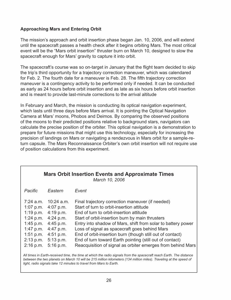
The mission’s approach and orbit insertion phase began Jan. 10, �006, and will extend until the spacecraft passes a health check after it begins orbiting Mars. The most critical event will be the “Mars orbit insertion” thruster burn on March 10, designed to slow the spacecraft enough for Mars’ gravity to capture it into orbit.
The spacecraft’s course was so on-target in January that the flight team decided to skip the trip’s third opportunity for a trajectory correction maneuver, which was calendared for Feb. 2. The fourth date for a maneuver is Feb. 28. The fifth trajectory correction maneuver is a contingency activity to be performed only if needed. It can be conducted as early as �4 hours before orbit insertion and as late as six hours before orbit insertion and is meant to provide last-minute corrections to the arrival altitude
In February and March, the mission is conducting its optical navigation experiment, which lasts until three days before Mars arrival. It is pointing the Optical Navigation Camera at Mars’ moons, Phobos and Deimos. By comparing the observed positions of the moons to their predicted positions relative to background stars, navigators can calculate the precise position of the orbiter. This optical navigation is a demonstration to prepare for future missions that might use this technology, especially for increasing the precision of landings on Mars or navigating a rendezvous in Mars orbit for a sample-re-turn capsule. The Mars Reconnaissance Orbiter’s own orbit insertion will not require use of position calculations from this experiment.
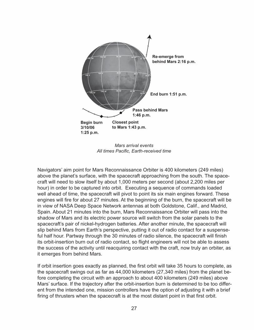
Mars Orbit Insertion Events and Approximate TimesMarch 10, 2006
Pacific Eastern Event 7:�4 a.m. 10:�4 a.m. Final trajectory correction maneuver (if needed) 1:07 p.m. 4:07 p.m. Start of turn to orbit-insertion attitude 1:19 p.m. 4:19 p.m. End of turn to orbit-insertion attitude 1:�4 p.m. 4:�4 p.m. Start of orbit-insertion burn by main thrusters 1:45 p.m. 4:45 p.m. Entry into shadow of Mars, shift from solar to battery power 1:47 p.m. 4:47 p.m. Loss of signal as spacecraft goes behind Mars 1:51 p.m. 4:51 p.m. End of orbit-insertion burn (though still out of contact) �:1� p.m. 5:1� p.m. End of turn toward Earth pointing (still out of contact) �:16 p.m. 5:16 p.m. Reacquisition of signal as orbiter emerges from behind Mars
All times in Earth-received time, the time at which the radio signals from the spacecraft reach Earth. The distance between the two planets on March 10 will be 215 million kilometers (134 million miles). Traveling at the speed of light, radio signals take 12 minutes to travel from Mars to Earth.
�7
Navigators’ aim point for Mars Reconnaissance Orbiter is 400 kilometers (�49 miles) above the planet’s surface, with the spacecraft approaching from the south. The space-craft will need to slow itself by about 1,000 meters per second (about �,�00 miles per hour) in order to be captured into orbit. Executing a sequence of commands loaded well ahead of time, the spacecraft will pivot to point its six main engines forward. These engines will fire for about 27 minutes. At the beginning of the burn, the spacecraft will be in view of NASA Deep Space Network antennas at both Goldstone, Calif., and Madrid, Spain. About �1 minutes into the burn, Mars Reconnaissance Orbiter will pass into the shadow of Mars and its electric power source will switch from the solar panels to the spacecraft’s pair of nickel-hydrogen batteries. After another minute, the spacecraft will slip behind Mars from Earth’s perspective, putting it out of radio contact for a suspense-ful half hour. Partway through the 30 minutes of radio silence, the spacecraft will finish its orbit-insertion burn out of radio contact, so flight engineers will not be able to assess the success of the activity until reacquiring contact with the craft, now truly an orbiter, as it emerges from behind Mars.
If orbit insertion goes exactly as planned, the first orbit will take 35 hours to complete, as the spacecraft swings out as far as 44,000 kilometers (�7,�40 miles) from the planet be-fore completing the circuit with an approach to about 400 kilometers (�49 miles) above Mars’ surface. If the trajectory after the orbit-insertion burn is determined to be too differ-ent from the intended one, mission controllers have the option of adjusting it with a brief firing of thrusters when the spacecraft is at the most distant point in that first orbit.
120 30'
120 0'
120 30'
90 30'
90 0'
90 30'
60 30'30 30'
30 0'
30 30'
60 0'
60 30'
150 30'
150 30'
150 0'
Begin burn3/10/061:25 p.m.
Closest pointto Mars 1:43 p.m.
Pass behind Mars1:46 p.m.
End burn 1:51 p.m.
Re-emerge frombehind Mars 2:16 p.m.
Mars arrival eventsAll times Pacific, Earth-received time
�8
Several activities are planned for the first few elongated orbits around Mars. Engineers will check the spacecraft’s health and status during the first two. The three cameras from the science payload -- the High Resolution Imaging Science Experiment, the Con-text Camera, and the Mars Color Imager -- will take their first test images of Mars as the orbiter passes low over the southern hemisphere near the end of the third orbit, on March 14. The following day, the Mars Climate Sounder instrument will scan the atmo-sphere over Mars’ northern hemisphere, a check of that instrument’s capability to aid in planning aerobraking events by identifying variations in atmospheric density. Late in the fourth orbit, on March 16, a jitter test will be conducted to determine whether image quality is affected by operating motors of other instruments at the same time the high-resolution camera is taking an image.
Also, before the start of aerobraking, the ground crew will run final rehearsals of the aerobraking procedures.
Aerobraking
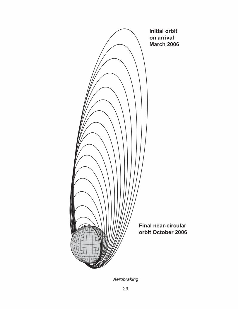
Aerobraking uses atmospheric drag with the planet’s upper atmosphere to slow the orbiting spacecraft and change the shape of its orbit. The shape of the orbit Mars Re-connaissance Orbiter should fly for making best use of its science instruments has been carefully designed. The desired orbit is a near-polar, low-altitude orbit whose most distant altitude at ��0 kilometers (199 miles) is about �5 percent farther from the planet than its closest point at �55 kilometers (158 miles). Initially, the orbit-insertion engine burn will put the spacecraft into an orbit with a very different shape, with the most distant point about 110 times farther from the planet than the closest point. Beginning about March �0, the mission will use hundreds of carefully calculated aerobraking dips into the upper atmosphere over the course of about six months to achieve that dramatic change in shape.
The process uses brief burns from the thrusters while the spacecraft is at the far end of the ellipse -- called the “apoasis.” The burns are used only to adjust how deeply the spacecraft dips into the atmosphere at the near end or “periapsis” end of the ellipse, where the orbit comes closest to the planet. It is the atmospheric drag on the spacecraft during the periapsis part of the orbit that does most of the work to decrease the apoap-sis altitude. Compared to relying only on rocket engines to shape orbits, aerobraking reduces the amount of fuel that must be launched from Earth by nearly one-half. This is the motive for aerobraking, a technique NASA has previously used with success for the Mars Global Surveyor and Mars Odyssey orbiters.
Generally, the density of a planetary atmosphere decreases with increasing altitude. However, Mars’ upper atmosphere is quite changeable in how dense it is at any given altitude. Experience gained from earlier orbiters plus monitoring by this mission’s own Atmospheric Structure Investigation will aid calculations of how low to bring the periap-sis from day to day. This constant monitoring is necessary because efficient aerobraking
�9
Initial orbiton arrivalMarch 2006
Final near-circularorbit October 2006
Aerobraking
�0
requires a balance between getting enough friction to slow the spacecraft but not too much heating. Too much friction could overheat the spacecraft. Too little could prevent getting the orbit to the right shape in time to lock it into the desired time-of-day pattern for the mission’s science phase.
In its configuration for aerobraking, the orbiter presents a frontal area of 37.5 square meters (404 square feet) including the back surfaces of the solar panels and high-gain antenna. The more compact and massive main structure of the spacecraft is out in front of these larger surfaces in the direction of travel. This configuration gives the spacecraft a self-righting stability comparable to a badminton shuttlecock.
Mars Reconnaissance Orbiter will begin the main phase of aerobraking about �0 days after arriving at Mars. This busy month will be spent on final preparations to get both the spacecraft and the teams on the ground ready for the intense months ahead. The first week will be used to monitor the health of the spacecraft and transition from the configuration used during the approach and orbit insertion phase to one that is better suited to aerobraking operations. Also during this week, three science calibrations will be performed to determine which camera settings will work best using data from Mars to adjust focus and other parameters. The final steps to enter the atmosphere of Mars will be in a “walk-in” phase during the three weeks after the science calibrations. The walk-in will gradually lower the altitude of periapsis from 400 kilometers (�49 miles) to about 100 kilometers (6� miles) over the southern hemisphere of Mars. At altitudes this low, the spacecraft will be encountering enough drag to aerobrake. The main phase of aerobraking will proceed from there, lasting about five months and concluding with a “walk-out” of the atmosphere that will take about five days.
During walk-in, thruster burns when the spacecraft is farthest from the planet will incre-mentally lower the other end of the orbit enough for the spacecraft to begin encoun-tering atmospheric drag. Once the periapsis lowers to the altitude where the optimal amount of atmospheric drag is found, the main phase of aerobraking will begin to use that drag to lower the apoapsis. As the orbit shrinks in size, it will also lessen in duration. At the start of the main phase of aerobraking, each orbit will take �5 hours to complete. By the end of the main phase, the spacecraft will be completing an orbit in less than two hours. The walk-out phase will raise the periapsis back out of the atmosphere. This will slow the final process and prevent overheating during long drag passes as the orbit becomes more circular and the speed at periapsis is significantly reduced.
After aerobraking has been completed, a few transition activities in September and October �006 will get the spacecraft ready to begin its primary science phase. These include three or four thruster-firing maneuvers for fine-tuning the shape of the orbit, de-ployment of the antenna for the radar, opening the cover on the imaging spectrometer, and final testing and calibration of scientific instruments.
The orbit and the spacecraft will be ready for the start of the mission’s main event, the primary science phase. But just before that phase begins, the geometry of the sun,
�1
Earth and Mars will interrupt communications while Mars passes behind the sun, from Earth’s perspective. This event, called a “solar conjunction,” occurs about every �6 months. Radio signals between Mars and Earth during a conjunction pass too close to the sun to be received reliably. For mission-planning purposes, the conjunction is con-sidered to last as long as Mars and the sun are less than five degrees apart in Earth’s sky, from Oct. 7, �006, to Nov. 8, �006.
Science Phase
During its primary science phase, from November �006 to December �008, Mars Re-connaissance Orbiter will examine parts of the planet in unprecedented detail and moni-tor the entire planet daily throughout a full cycle of Martian seasons. Beginning right after solar conjunction allows slightly more than one Martian year of observations with-out interruption by another conjunction. Mars will be about one-third of the way through a northern hemisphere summer in November �006.
Throughout the science phase, the orbiter will generally keep its instruments pointed at Mars to collect data and its high-gain antenna pointed at Earth to send the data home. With daily support by NASA’s Deep Space Network for receiving the data on Earth, Mars Reconnaissance Orbiter will return more than five times as much data as all previ-ous missions to Mars combined.
The primary science orbit is designed to serve the mission’s research goals. The space-craft will pass almost directly over the poles on each orbit. The orbit will remain at a fixed angle to the Sun; every time the spacecraft passes northbound over the equator, it will see mid-afternoon lighting on the ground. A complete orbit will take about 1 hour and 5� minutes. By the next time the orbiter comes around and crosses the equator again, the planet underneath will have rotated just enough that the orbiter sees the same time-of-day on the ground beneath it.
In altitude, the slightly elliptical orbit will range from �55 kilometers (158 miles) at the low point, or periapsis, to ��0 kilometers (199 miles) at the highest point, or apoapsis. The periapsis will be over the south pole, the apoapsis over the north pole. This shape reflects the slightly asymmetrical shape of Mars and so it deviates from a circular orbit. For comparison with the orbiters currently at Mars, Mars Global Surveyor flies a nearly circular orbit at about 378 kilometers (235 miles), Mars Odyssey flies one at 400 kilome-ters (250 miles), and Mars Express flies an elliptical, 7.5-hour orbit ranging from 259 to 11,560 kilometers (161 to 7,18� miles).
The primary science orbit for Mars Reconnaissance Orbiter will have two cycles of repeating its ground track to allow researchers to go back for a closer look at features seen in regional surveys. That is, �59 days after any given orbit, the spacecraft will re-peat essentially the same path as the earlier orbit. However, there is a much shorter cy-cle of 17 days in which any place on the planet can be viewed by rolling the spacecraft up to �0 degrees to the left or right of straight-downward (nadir) pointing of the instru-
��
ment deck. Thus, a given target can be viewed in any 17-day cycle or can be viewed from different direction (e.g., as need for stereo images) in two successive cycles.
Relay Phase
A two-year phase when Mars Reconnaissance Orbiter’s primary mission will be com-munications support for other missions, is scheduled to begin when the primary science phase ends in December �008 and run for two years. Important relay support will begin, however, when MRO begins its own science phase if Spirit or Opportunity is still operat-ing on the surface.
The Electra communications package on Mars Reconnaissance Orbiter will enable the orbiter to assist with navigation and communication for spacecraft arriving at Mars. It will be able to communicate with spacecraft on the surface of Mars at data rates from 1 kilobit per second to � megabits per second. The relay can work only when the orbiter is about �0 degrees or more above the horizon from the perspective of a lander or rover on the surface. Due to the orbiter’s relatively low altitude, that will limit each relay ses-sion to about five minutes or less. Communications between the orbiter and a lander or rover will take advantage of the development of an international standard, called the Proximity-1 protocol, for the data transfer. The Consultative Committee for Space Data Systems, an international partnership for standardizing techniques used for handling space data, developed Proximity-1.
The surprisingly long lives of NASA’s Mars Exploration Rovers have made it likely that Spirit or Opportunity will be the first user of Mars Reconnaissance Orbiter’s relay capa-bilities. Those rovers have relied on NASA’s Mars Odyssey for relaying more than 90 percent of the data they have returned, and have also used NASA’s Mars Global Sur-veyor and the European Space Agency’s Mars Express to relay data.
NASA’s Phoenix Mars Scout mission is in development for launch in August �007 and landing in May �008. Phoenix would land in icy soils near the north polar ice cap of Mars and spend up to three months examining the history of the water in these soils, checking for organic chemicals and monitoring polar climate. Plans for the Phoenix mis-sion envision support from Mars Reconnaissance Orbiter for navigation and communi-cation during the approach to Mars, then two to three relay contacts daily at rates of up to 1�8 kilobits per second during Phoenix’ surface operations.
NASA’s Jet Propulsion Laboratory is developing the next-generation Mars rover, with a science payload about 10 times as massive as the current rovers’. This rover, called Mars Science Laboratory, is slated for launch in October �009 and landing on Mars in October �010. Mars Reconnaissance Orbiter will have an important role as communica-tions relay for Mars Science laboratory.
��
End of Mission
The Mars Reconnaissance Orbiter’s prime mission will end Dec. �1, �010, after the two-year-long relay phase. At the end of the prime mission, the orbiter’s thrusters will take the spacecraft to a higher orbit to put it into better geometry for any future communica-tions-relay work and to extend its longevity in orbit. The end-of-mission orbit will be an ellipse ranging in altitude from about �50 to 410 kilometers (�17 to �55 miles).
The initial launch mass of the orbiter will includes more than enough propellant for the prime mission. Even after the end-of-mission maneuver, the orbiter is expected to have enough extra propellant for about five additional years of operation. Unless that propel-lant is needed for contingencies during the prime mission, NASA would have the option of assigning the orbiter an extended mission to continue support for future Mars mis-sions. From the end-of-mission orbit, Mars Reconnaissance Orbiter could supplement the relay support and would still be NASA’s most capable asset for evaluating potential landing sites for future missions even though imaging resolution would be reduced by �0 percent at the higher altitude. Assuming its atmospheric instruments were still oper-ating, the Mars Reconnaissance Orbiter could also provide near-real-time support for future landers, just as Mars Global Surveyor did for the Mars Exploration Rovers.
Communications
From launch day until the end of its operations, Mars Reconnaissance Orbiter will rely on NASA’s Deep Space Network of antenna stations on Earth. The radio links between the spacecraft and the Deep Space Network antennas will provide tracking capability during the trip to Mars; uplinked commands to the spacecraft; and downlink of all the engineering, science-instrument and relayed data from the orbiter.
The Deep Space Network transmits and receives radio signals through large dish antennas at three sites spaced approximately one-third of the way around the world from each other. This configuration ensures that spacecraft remain in view of one an-tenna complex or another as Earth rotates. The antenna complexes are at Goldstone in California’s Mojave Desert; near Madrid, Spain; and near Canberra, Australia. Each complex is equipped with one antenna 70 meters (��0 feet) in diameter, at least two antennas �4 meters (11� feet) in diameter, and smaller antennas. All three complexes communicate directly with the control hub at NASA’s Jet Propulsion Laboratory, Pasade-na, Calif. The network provided routine communications for 30 flying spacecraft during the second quarter of �005.
The orbiter is expected to return �4 terabits of data during its primary science phase, more than five times all previous Mars missions combined. Most of that data will come through two sessions per day, each about eight hours long, using �4-meter antennas. Plans call for using 70-meter antennas for supplemental coverage during the portions of the primary science when Mars is farthest from Earth.
�4
Mars and Earth will be about �84 million kilometers (�.�9 million miles) apart -- nearly their maximum distance from each other -- right at the beginning of the orbiter’s primary science phase in November �006. At that distance, radio signals traveling at the speed of light take about �1 minutes to make the one-way trip, and the orbiter is expected to send data to a �4-meter antenna on Earth at a rate of about 600 kilobits per second (about three CD-ROMs worth of data per hour). The minimum Earth-Mars distance during the orbiter’s prime mission will be in December �007, when the two planets will come within 88 million kilometers (55 million miles) of each other. Radio signals travel that distance in about four minutes, and Mars Reconnaissance Orbiter is expected to transmit to a �4-meter antenna that far away at a rate of about �.6 megabits per second (about 14 CD-ROMs worth of data per hour). The spacecraft’s maximum data-transmis-sion rate, with a 70-meter antenna on the receiving end, is expected to be about �.5 megabits per second, fast enough to fill a CD-ROM in about three minutes.The mission will use X-band radio frequencies as its principal communication chan-nel with Earth. Counting the capacity from supplemental use of 70-meter antennas as well as two daily sessions with �4-meter ones, the quantity of data received per day via X band is expected to vary from about 40 to 90 gigabits (about 60 to 140 CD-ROMs worth). The mission will also demonstrate the use of Ka band radio frequencies. After that demonstration’s goals are met, Ka band transmissions might add significantly to the total amount of science data sent to Earth by the orbiter. The Ka band equipment uses less power than its X band counterpart to send the same amount of data. However, Ka band transmissions are more susceptible to being disrupted by water in Earth’s atmo-sphere.
Planetary Protection Requirements
In the study of whether Mars has had environments conducive to life, precautions are taken against introducing microbes from Earth. The United States is a signatory to an international treaty that stipulates that exploration must be conducted in a manner that avoids harmful contamination of celestial bodies. In compliance with that treaty, the flight hardware of the Mars Reconnaissance Orbiter has been designed to meet NASA’s Planetary Protection Policy.
For a planetary orbiter mission such as this, the current policy offers two alternative strategies: by assuring a long-term orbital lifetime (more than 50 years) or by flying a very clean spacecraft (measured by a microbiological burden of no more than 50,000 microbial spores). The low-altitude orbit needed for the mission to achieve its science goals makes it unfeasible to depend on impact avoidance, since a low-altitude space-craft failure could result in an impact of Mars considerably before 50 years passes. Consequently, the project has demonstrated compliance with the total microbiological burden requirement.
In the event of a premature entry into the martian atmosphere, portions of the space-craft that will be heated to 500 degrees Celsius (9�� degrees Fahrenheit) or hotter for at least half a second during friction with Mars’ atmosphere will be sterilized by that pro-

�5
cess. For other parts of the spacecraft, a combination of dry-heat microbial reduction, manufacturing controls and cleaning are keeping the number of spores within permis-sible levels.
Another type of precaution is to be sure any hardware that doesn’t meet these stan-dards does not go to Mars accidentally. When the Atlas V’s Centaur upper stage sepa-rates from the spacecraft, the two objects are traveling on nearly identical trajectories. To prevent the possibility of the Centaur hitting Mars, that shared course is deliberately set so that the spacecraft would miss Mars if not for its first trajectory correction maneu-ver, about 15 days later.
The NASA planetary protection officer is responsible for the establishment and enforce-ment of the agency’s planetary protection regulations.
�6
Spacecraft The Mars Reconnaissance Orbiter spacecraft consists of the payload and the systems that enable the payload to do its job and send home the results.
The spacecraft has been assembled around a main structure made of strong, light-weight materials including titanium, carbon composites and aluminum honeycomb. Propulsion Subsystem
The spacecraft’s propulsion system will perform maneuvers such as trajectory correc-tions during the cruise to Mars, braking to insert the spacecraft into orbit the day it ar-rives, and orbit adjustments during aerobraking.
The orbiter carries a total of �0 small rocket engines, or thrusters, of three sizes. The six largest ones each produce about 170 newtons (�8 pounds) of thrust when they are in use. The main function for these six is to slow the spacecraft’s velocity as it first flies close to Mars so that it will be captured into orbit by Mars’ gravity. All six will fire at the same time for this mission-critical event, called Mars orbit insertion. By using relatively small engines rather than a single larger one, the mission is less susceptible to an orbit-insertion failure due to an engine malfunction. The six 170-newton thrusters will also be used for the spacecraft’s first trajectory correction maneuver, scheduled for 15 days after launch.
Six intermediate thrusters can each produce �� newtons (5 pounds) of thrust. They will be used for other trajectory correction maneuvers during the trip to Mars and for the maneuvers to adjust the altitude of aerobraking dips into the upper atmosphere. The smallest eight thrusters each produce 0.9 newtons (0.� pounds) of thrust. They can control the orientation of the spacecraft as an alternate system to attitude-control reac-tion wheels or when the momentum built up in the wheels needs to be reduced. They will also be used to control rolling of the spacecraft during orbit insertion and trajectory correction maneuvers.
All of the thrusters consume hydrazine, a propellant that does not require an oxygen source. Hydrazine is a corrosive liquid compound of nitrogen and hydrogen that decom-poses explosively into expanding gases when exposed to a catalyst in the thrusters. The spacecraft’s propellant tank can hold the 1,��0 kilograms (�,690 pounds) of hydra-zine fuel, about 70 percent of which will be used for orbit insertion. To push the hydra-zine to the thrusters, the spacecraft uses pressurized helium stored in a separate tank.
Power Subsystem
The spacecraft’s electrical power comes from two solar arrays, with a pair of nickel-hy-drogen batteries to fill in when the spacecraft is in the shadow of a planet or the arrays
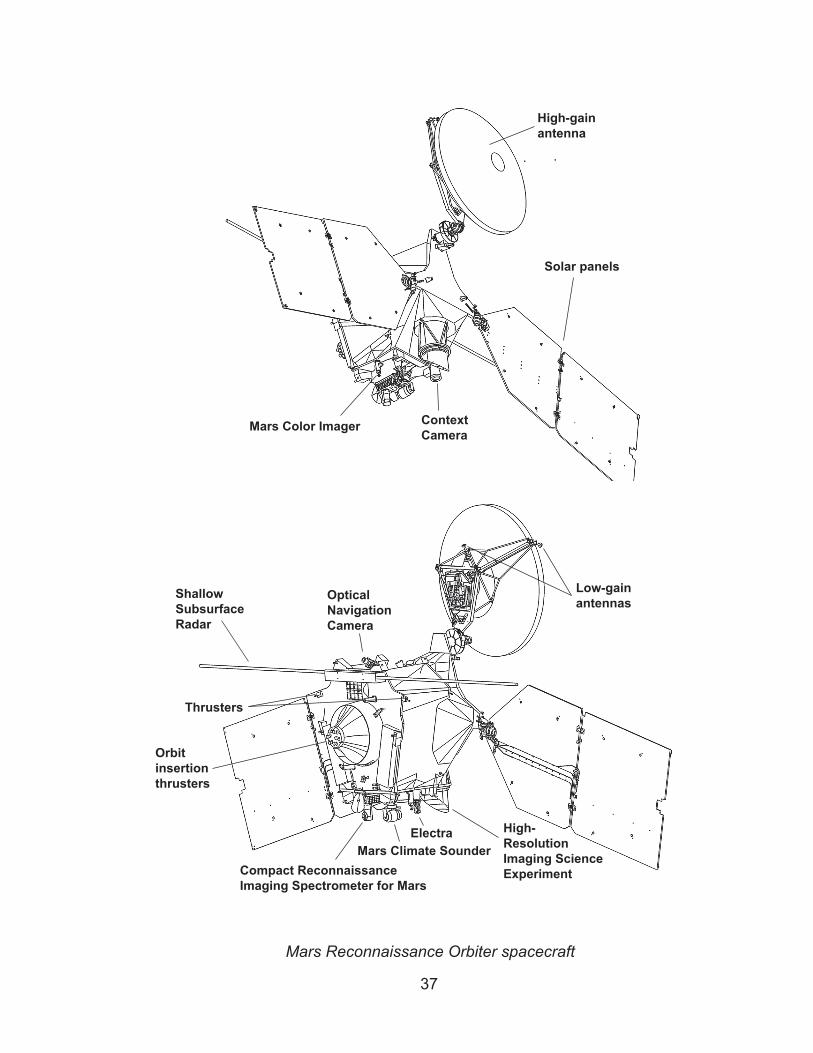
�7
Mars Color Imager ContextCamera
High-gainantenna
Solar panels
ShallowSubsurfaceRadar
Compact ReconnaissanceImaging Spectrometer for Mars
Mars Climate SounderElectra High-
ResolutionImaging ScienceExperiment
OpticalNavigationCamera
Orbitinsertionthrusters
Thrusters
Low-gainantennas
Mars Reconnaissance Orbiter spacecraft
�8
are not facing the Sun. Each array is 5.�5 meters (17.56 feet) long by �.5� meters (8.�0 feet) wide. On the front side, 9.5 square meters (10� square feet) of the surface is covered with �,744 individual photovoltaic cells. The cells can convert about �6 per-cent of the solar energy that hits them into electricity. At Earth, the two panels combined can generate about 6,000 watts. But at Mars, sunshine is weaker and the output will be �,000 watts. The arrays are mounted on opposite sides of the orbiter, with a gimbaled connection that allows them to be turned at any angle to face the Sun.
Communications Subsystem
To communicate with Earth, the spacecraft has three antennas, three amplifiers and two transponders. It has the capacity to transmit data at up to 6 megabits per second, but in practical use transmitting from Mars to Earth it’s peak rate is expected to be about �.5 megabits per second, about 10 times higher than any previous Mars mission has used.
The main antenna is the biggest thing on the spacecraft other than the solar panels. It is a parabolic dish antenna � meters (10 feet) in diameter, mounted with a gimbal that al-lows it to be pointed without needing to change the orientation of the whole spacecraft. This is the high-gain antenna, meaning it is highly effective in pulling in or sending out a signal. It must be pointed at Earth to be effective. The spacecraft’s other two antennas are smaller, low-gain antennas, which cannot communicate at such high data rates, but do not need to be pointed at Earth to work. They serve as backups for emergencies and special events, such as launch and orbit insertion. The low-gain antennas are mounted on the high-gain antenna, one facing forward and the other backward so that communi-cation with Earth will be possible regardless of the spacecraft’s orientation.
Two of the three amplifiers boost signals in the X-band of radio frequencies, planned as the primary channel for the mission. One of these is a backup in case the first fails. Each can send signals at 100 watts of power. The third amplifier supports the mission’s demonstration of using the shorter-wavelength Ka band as an alternate channel. It can send signals at �5 watts.
The orbiter’s transponders translate between digital data (the ones and zeros used by computers) and radio signals, modulating the outgoing signals to put data into them and demodulating signals received from the ground. They also have two specialized func-tions: transmitting in ways that provide spacecraft-position information to navigators and automatically responding when they detect incoming signals. One of the two transpon-ders is a backup to the other.
In addition to its subsystem for communication with Earth, Mars Reconnaissance Orbiter carries a communication package called Electra for communicating with other space-craft near Mars or on Mars. Electra will use the ultra-high-frequency radio band.
�9
Command and Data Handling Subsystem
The spacecraft will manage its data with a space flight computer and a solid-state re-corder.
The computer features an X�000 Rad 750 microprocessor, a computer chip based on a 1�� megahertz PowerPC processor but enhanced to reliably endure the natural radia-tion and other rigors of an outer-space environment. The Rad 750 provides processing power of up to 48 million instructions per second for use by payload instruments as well as the spacecraft subsystems.
The computer will run flight software, which includes many applications for operating the spacecraft, for protecting its health if problems arise and for recovering from problems.
The solid-state recorder provides storage space for up to 160 gigabits of information. It will be the primary location for holding data from the science instruments until it can be transmitted to Earth. The computer also has available 1�8 megabytes of high-speed, random-access memory.
Guidance, Navigation and Control Subsystem
To control which way it is pointing, the spacecraft will use several instruments to sense its orientation and movement, and dual systems for changing its orientation, such as for pointing of instruments.
Each of two star trackers (one of which is a backup) is a camera that takes pictures of the sky and has computer power to compare the images with a catalog of star positions and recognize which part of the sky it is facing. This gives precise information about the spacecraft’s orientation, and the trackers can update the information several times per second. Sixteen Sun sensors (eight of which are backups) are mounted at various points around the spacecraft and report whether or not sunlight is hitting them. If the spacecraft loses its bearings, these sensors enable it to locate the Sun so that it can turn the solar arrays toward the Sun.
An instrument called an inertial measurement unit, which also has a back-up dupli-cate, includes accelerometers to measure changes in the spacecraft’s velocity in any direction and ring-laser gyroscopes to measure how fast the spacecraft’s orientation is changing.
To change its orientation, the orbiter’s primary tool is a set of three 10-kilogram (��-pound) reaction wheels spinning at right angles to each other (plus a spare). Speeding up the rotation of a wheel turns the spacecraft in the opposite direction from that wheel’s spin. It’s the basic physics of every action having an opposite reaction. Orientation can also be changed with the spacecraft’s smallest thrusters. That method can accomplish a turn faster, but it uses some of the limited supply of propellant and the motion is not

40
as smooth as a turn using reaction wheels. With repeated use, the reaction wheels spin faster and faster. Occasionally they need to be slowed down. While the wheels are be-ing slowed, the thrusters are used to maintain the spacecraft’s orientation.
41
Mars: The Water TrailForty years ago, as the world eagerly awaited results of the first spacecraft flyby of Mars, everything we knew about the Red Planet was based on what sparse details could be gleaned by peering at it from telescopes on Earth. Since the early 1900s, popular culture had been enlivened by the notion of a habitable neighboring world crisscrossed by canals and, possibly, inhabited by advanced lifeforms that might have built them -- whether friendly or not. Astronomers were highly skeptical about the ca-nals, which looked more dubious the closer they looked. About the only hard information they had on Mars was that they could see it had seasons with ice caps that waxed and waned, along with seasonally changing surface markings. By breaking down the light from Mars into colors, they learned that its atmosphere was thin and dominated by an unbreathable gas, carbon dioxide.
The past four decades have completely revolutionized that view. First, hopes of a lush, Earth-like world were deflated when Mariner 4’s flyby on July 15, 1965, revealed large impact craters, not unlike those on Earth’s barren, lifeless moon. Those holding out for Martians were further discouraged when NASA’s two Viking landers were sent to the surface in 1976 equipped with a suite of chemistry experiments that turned up no con-clusive sign of biological activity. Mars as we came to know it was cold, nearly airless and bombarded by hostile radiation from both the Sun and from deep space.
But along the way since then, new possibilities of a more hospitable Martian past have emerged. Mars is a much more complex body than Earth’s moon. Scientists scrutinizing pictures from the Viking orbiters have detected potential signs of an ancient coastline that may have marked the edges of a long-lost sea. The three orbiters and two rovers active at Mars in �005 have each advanced the story. The accumulated evidence shows that the surface of Mars appears to be shaped by flowing water in hundreds of places; that some Mars rocks formed in water; and that, still today, significant amounts of water as ice or hydrated minerals make up a fraction of the top surface layer of Mars from high latitudes to some mid-latitude regions.
Although it appears unlikely that complex organisms similar to Earth’s could have exist-ed on Mars’ comparatively hostile surface, scientists are intrigued by the possibility that life in some form, perhaps very simple microbes, may have gained a foothold in ancient times when Mars may have been warmer and wetter. It is not unthinkable that life in some form could persist today in underground springs warmed by heat vents around smoldering volcanoes, or even beneath the thick ice caps. To investigate those possi-bilities, the most promising strategy is to learn more about the history of water on Mars: How much was there? How long did it last? Where were the formerly wet environments that make the best destinations for seeking evidence of past life? Where might there be wet environments capable of sustaining life today?
The consensus strategy for answering those questions uses a balance of examining se-
4�
lected sites in great detail while also conducting planet-wide surveys to provide context for interpreting the selected sites, to extrapolate from the intensively investigated sites to regional and global patterns, and to identify which specific sites make the best candi-dates for targeted examination.
One way this balance works is in the combination punch of orbital and surface missions. Mineral mapping by Mars Global Surveyor identified the hematite deposit that made Meridiani Planum one of the top-priority targets selected as landing sites for the Mars Exploration Rovers. The hematite suggested a possible water history. The rover Op-portunity’s intensive examination of the composition and fine structure of rocks where it landed confirmed that the site had been covered with water and added details about the acidity of the water and the alternation of wet and dry periods at the site. This “ground truthing” by the rover improves interpretation of current orbiters’ observations of the surrounding region; the orbiters’ observations add context for understanding how the environment that the landing-site rocks reveal about a particular place and time fits into a broader history.
The mission of the Mars Reconnaissance Orbiter is another manifestation of combin-ing targeted inspection with wider surveys. This spacecraft will examine selected sites in greater detail than any previous Mars orbiter -- with high enough resolution to see individual rocks as small as some that Opportunity has drilled into, to identify minerals in deposits no larger than the crater (dubbed “Eagle”) where Opportunity landed and to distinguish between buried layers as thin as about 7.5 meters (�5 feet) thick. It will also observe the entire planet every day and make regional surveys as context for the high-resolution observations. The mission’s goals include both providing information from orbit about the history of water on Mars and also identifying the best sites for future landings.
Myths and Reality
Mars caught public fancy in the late 1870s, when Italian astronomer Giovanni Schia-parelli reported using a telescope to observe “canali,” or channels, on Mars. A possible mistranslation of this word as “canals” may have fired the imagination of Percival Low-ell, an American businessman with an interest in astronomy. Lowell founded an ob-servatory in Arizona, where his observations of the Red Planet convinced him that the canals were dug by intelligent beings -- a view that he energetically promoted for many years.
By the turn of the last century, popular songs envisioned sending messages between worlds by way of huge signal mirrors. On the dark side, H.G. Wells’ 1898 novel “The War of the Worlds” portrayed an invasion of Earth by technologically superior Martians desperate for water. In the early 1900s novelist Edgar Rice Burroughs, known for the “Tarzan” series, also entertained young readers with tales of adventures among the exotic inhabitants of Mars, which he called Barsoom.
4�
Fact began to turn against such imaginings when the first robotic spacecraft were sent to Mars in the 1960s. Pictures from the 1965 flyby of Mariner 4 and the 1969 flybys of Mariner 6 and 7 showed a desolate world, pocked with impact craters similar to those seen on Earth’s moon. Mariner 9 arrived in 1971 to orbit Mars for the first time, but showed up just as an enormous dust storm was engulfing the entire planet. When the storm died down, Mariner 9 revealed a world that, while partly crater-pocked like Earth’s moon, was much more geologically complex, complete with gigantic canyons, volca-noes, dune fields and polar ice caps. This first wave of Mars exploration culminated in the Viking mission, which sent two orbiters and two landers to the planet in 1975. The landers included a suite of experiments that conducted chemical tests to detect life. Most scientists interpreted the results of these tests as negative, deflating hopes of identifying another world on where life might be or have been widespread. However, Viking left a huge legacy of information about Mars that fed a hungry science community for two decades.
The science community had many other reasons for being interested in Mars, apart from the direct search for life; the next mission on the drawing boards concentrated on a study of the planet’s geology and climate using advanced orbital reconnaissance. Over the next 20 years, however, new findings in laboratories and in extreme environments on Earth came to change the way that scientists thought about life and Mars.
One was the 1996 announcement by a team from Stanford University and NASA’s Johnson Space Center that a meteorite believed to have originated on Mars contained what might be the fossils of ancient bacteria. This rock and other Mars meteorites dis-covered on several continents on Earth appear to have been blasted off the Red Planet by asteroid or comet impacts. The evidence that they are from Mars comes from gases trapped in them that unmistakably match the composition of Mars’ atmosphere as mea-sured by the Viking landers. Many scientists questioned the conclusions of the team announcing the discovery of possible life in one Martian meteorite, but if nothing else the mere presence of organic compounds in the meteorites increases the odds of life forming at an earlier time on a far wetter Mars.
Another development shaping ideas about extraterrestrial life was a string of spectacu-lar findings on how and where life thrives on Earth. The fundamental requirements for life as we know it today are liquid water, organic compounds and an energy source for synthesizing complex organic molecules. In recent years, it has become increasingly clear that life can thrive in settings much harsher than what we can experience.
In the 1980s and 1990s, biologists found that microbial life has an amazing flexibility for surviving in extreme environments -- niches that by turn are extraordinarily hot, or cold, or dry, or under immense pressures -- that would be completely inhospitable to humans or complex animals. Some scientists even concluded that life may have begun on Earth in hot vents far under the ocean’s surface.
This in turn had its effect on how scientists thought about Mars. Martian life might not be
44
so widespread that it would be readily found at the foot of a lander spacecraft, but it may have thrived billions of years ago in an underground thermal spring or other hospitable environment. Or it might still exist in some form in niches below the currently frigid, dry, windswept surface, perhaps entombed in ice or in liquid water aquifers.
Each successful Mars mission reads more pages of the planet’s story. After years of studying pictures from the Viking orbiters, scientists gradually came to conclude that many features they saw suggested that Mars may have been warm and wet in an ear-lier era. Two decades after Viking, Mars Pathfinder observed rounded pebbles and sockets in larger rocks, suggesting conglomerates that formed in running water. Mars Global Surveyor’s camera has detected possible evidence for recent liquid water in many settings, including hundreds of hillside gullies. Mars Odyssey’s spectrometers have found large amounts of ice mixed in with Mars surface materials. Observations by Global Surveyor and Odyssey have also been interpreted as evidence that Mars is still adjusting from a recent ice age as part of a repeating cycle of global climate change. NASA’s Mars Exploration Rover Opportunity established that rocks in at least one part of Mars were formed underneath flowing surface water. Halfway around the planet, its twin rover, Spirit, also found rocks extensively altered by water. The European Space Agency’s Mars Express has identified exposures of water-related minerals. That space-craft and telescopic studies from Earth have found traces of atmospheric methane at Mars that might come from volcanic or biological sources.
Three Ages of Mars
Based on what they have learned from spacecraft missions, scientists view Mars as the “in-between” planet of the inner solar system. Small rocky planetary bodies such as Mercury and Earth’s moon apparently did not have enough internal heat to power volcanoes or to drive the motion of tectonic plates, so their crusts grew cold and static relatively soon after they formed when the solar system condensed into planets about 4.6 billion years ago. Devoid of atmospheres, they are riddled with craters that are relics of impacts during a period of bombardment when the inner planets were sweeping up remnants of small rocky bodies that failed to “make it as planets” in the solar system’s early times.
Earth and Venus, by contrast, are larger planets with substantial internal heat sources and significant atmospheres. Earth’s surface is continually reshaped by tectonic plates sliding under and against each other and by materials spouting forth from active volca-noes where plates are ripped apart. Both Earth and Venus have been paved over so recently that both lack any discernible record of cratering from the era of bombardment in the early solar system.
Mars appears to stand between those sets of worlds, on the basis of current yet evolv-ing knowledge. Like Earth and Venus, it possesses a myriad of volcanoes, although they probably did not remain active as long as counterparts on Earth and Venus. On Earth, a single “hot spot” or plume might form a chain of middling-sized islands such as
45
the Hawaiian Islands as a tectonic plate slowly slides over it. On Mars there are ap-parently no such tectonic plates, at least as far as we know today, so when volcanoes formed in place they had the time to become much more enormous than the rapidly moving volcanoes on Earth. Overall Mars appears to be neither as dead as Mercury and our moon, nor as active as Earth and Venus. As one scientist quips, “Mars is a warm corpse if not a fire-breathing dragon.” Thanks to the ongoing observations by current missions, however, this view of Mars is still evolving.
Mars almost resembles two different worlds that have been glued together. From lati-tudes around the equator to the south are ancient highlands pockmarked with craters from the solar system’s early era, yet riddled with channels that attest to the flow of water. The northern third of the planet, however, overall is sunken and much smoother at kilometer (mile) scales. There is as yet no general agreement on how the northern plains got to be that way. At one end of the spectrum is the theory that it is the floor of an ancient sea; at the other, the notion that it is merely the end product of innumerable lava flows. New theories are emerging thanks to the discoveries of Mars Odyssey, and some scientists believe a giant ice sheet may be buried under much of the relatively smooth northern plains. Many scientists suspect that some unusual internal process not yet fully understood may have caused the northern plains to sink to relatively low eleva-tions in relation to the southern uplands.
Scientists today view Mars as having had three broad ages, each named for a geo-graphic area that typifies it:
q The Noachian Era is the name given to the time spanning perhaps the first billion years of Mars’ existence after the planet was formed 4.6 billion years ago. In this era, scientists suspect that Mars was quite active with periods of warm and wet environ-ment, erupting volcanoes and some degree of tectonic activity. The planet may have had a thicker atmosphere to support running water, and it may have rained and snowed.
q In the Hesperian Era, which lasted for about the next 500 million to 1.5 billion years, geologic activity was slowing down and near-surface water perhaps was freezing to form surface and buried ice masses. Plunging temperatures probably caused water pooled underground to erupt when heated by impacts in catastrophic floods that surged across vast stretches of the surface -- floods so powerful that they unleashed the force of thousands of Mississippi Rivers. Eventually, water became locked up as permafrost or subsurface ice, or was partially lost into outer space.
q The Amazonian Era is the current age that began around � billion to � billion years ago. The planet is now a dry, desiccating environment with only a modest atmo-sphere in relation to Earth. In fact, the atmosphere is so thin that water can exist only as a solid or a gas, but only temporarily as a liquid. Scientist are now learning that over millions of years, the planet can vary its tilt, severely altering climate and perhaps stabil-ity of water on the surface.

46
Apart from that broad outline, there is lively debate and disagreement on the details of Mars’ history. How wet was the planet, and how long ago? What eventually happened to all of the water? That is all a story that is still being written.
Even if we ultimately learn that Mars never harbored life as we know it here on Earth, scientific exploration of the Red Planet can assist in understanding the history and evolution of life on our own home world. Much if not all of the evidence for the origin of life here on Earth has been obliterated by the incredible pace of weathering and global tectonics that have operated over billions of years. Mars, by comparison, is a composite world with some regions that may have histories similar to Earth’s crust, while others serve as a frozen gallery of the solar system’s early days.
Thus, even if life never developed on Mars -- something that we cannot answer today -- scientific exploration of the planet may yield critical information unobtainable by any other means about the pre-biotic chemistry that led to life on Earth. Mars as a fossil graveyard of the chemical conditions that fostered life on Earth is an intriguing possibil-ity.
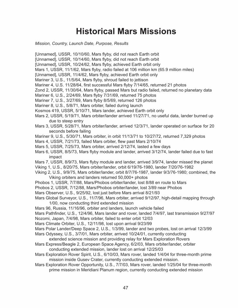
47
Historical Mars MissionsMission, Country, Launch Date, Purpose, Results
[Unnamed], USSR, 10/10/60, Mars flyby, did not reach Earth orbit[Unnamed], USSR, 10/14/60, Mars flyby, did not reach Earth orbit[Unnamed], USSR, 10/24/62, Mars flyby, achieved Earth orbit onlyMars 1, USSR, 11/1/62, Mars flyby, radio failed at 106 million km (65.9 million miles)[Unnamed], USSR, 11/4/62, Mars flyby, achieved Earth orbit onlyMariner 3, U.S., 11/5/64, Mars flyby, shroud failed to jettisonMariner 4, U.S. 11/28/64, first successful Mars flyby 7/14/65, returned 21 photosZond 2, USSR, 11/30/64, Mars flyby, passed Mars but radio failed, returned no planetary dataMariner 6, U.S., 2/24/69, Mars flyby 7/31/69, returned 75 photosMariner 7, U.S., 3/27/69, Mars flyby 8/5/69, returned 126 photosMariner 8, U.S., 5/8/71, Mars orbiter, failed during launchKosmos 419, USSR, 5/10/71, Mars lander, achieved Earth orbit onlyMars �, USSR, 5/19/71, Mars orbiter/lander arrived 11/�7/71, no useful data, lander burned up due to steep entryMars �, USSR, 5/�8/71, Mars orbiter/lander, arrived 1�/�/71, lander operated on surface for �0 seconds before failingMariner 9, U.S., 5/�0/71, Mars orbiter, in orbit 11/1�/71 to 10/�7/7�, returned 7,��9 photosMars 4, USSR, 7/21/73, failed Mars orbiter, flew past Mars 2/10/74Mars 5, USSR, 7/�5/7�, Mars orbiter, arrived �/1�/74, lasted a few daysMars 6, USSR, 8/5/73, Mars flyby module and lander, arrived 3/12/74, lander failed due to fast impactMars 7, USSR, 8/9/73, Mars flyby module and lander, arrived 3/9/74, lander missed the planetViking 1, U.S., 8/�0/75, Mars orbiter/lander, orbit 6/19/76-1980, lander 7/�0/76-198�Viking �, U.S., 9/9/75, Mars orbiter/lander, orbit 8/7/76-1987, lander 9/�/76-1980; combined, the Viking orbiters and landers returned 50,000+ photosPhobos 1, USSR, 7/7/88, Mars/Phobos orbiter/lander, lost 8/88 en route to MarsPhobos �, USSR, 7/1�/88, Mars/Phobos orbiter/lander, lost �/89 near PhobosMars Observer, U.S., 9/�5/9�, lost just before Mars arrival 8/�1/9�Mars Global Surveyor, U.S., 11/7/96, Mars orbiter, arrived 9/1�/97, high-detail mapping through 1/00, now conducting third extended mission Mars 96, Russia, 11/16/96, orbiter and landers, launch vehicle failedMars Pathfinder, U.S., 12/4/96, Mars lander and rover, landed 7/4/97, last transmission 9/27/97Nozomi, Japan, 7/4/98, Mars orbiter, failed to enter orbit 1�/0� Mars Climate Orbiter, U.S., 1�/11/98, lost upon arrival 9/��/99Mars Polar Lander/Deep Space �, U.S., 1/�/99, lander and two probes, lost on arrival 1�/�/99Mars Odyssey, U.S., �/7/01, Mars orbiter, arrived 10/�4/01, currently conducting extended science mission and providing relay for Mars Exploration RoversMars Express/Beagle �, European Space Agency, 6/�/0�, Mars orbiter/lander, orbiter conducting extended mission, lander lost on arrival 1�/�5/0�Mars Exploration Rover Spirit, U.S., 6/10/0�, Mars rover, landed 1/4/04 for three-month prime mission inside Gusev Crater, currently conducting extended mission.Mars Exploration Rover Opportunity, U.S., 7/7/0�, Mars rover, landed 1/�5/04 for three-month prime mission in Meridiani Planum region, currently conducting extended mission
48
Program/Project Management At NASA, the Mars Program is managed by the Science Mission Directorate. Dr. Mary Cleave is science associate administrator, Douglas McCuistion is Mars program direc-tor, Dr. Michael Meyer is the lead scientist for the Mars Exploration Program, Dr. Ramon DePaula is program executive for Mars Reconnaissance Orbiter and Dr. R. Stephen Saunders is program scientist for the Mars Reconnaissance Orbiter.
The Mars Program and the Mars Reconnaissance Orbiter project are managed by the Jet Propulsion Laboratory, Pasadena, Calif., for NASA’s Science Mission Directorate, Washington.
At the Jet Propulsion Laboratory, Dr. Fuk Li is the Mars program manager, Dr. Daniel McCleese is Mars chief scientist, Jim Graf is Mars Reconnaissance Orbiter project man-ager and Dr. Richard Zurek is Mars Reconnaissance Orbiter project scientist.
Lockheed Martin Space Systems, Denver, Colo., built the spacecraft and shares op-erational roles with JPL. Kevin McNeill is program manager at Lockheed Martin for the Mars Reconnaissance Orbiter.
�-�4-05
![Assimilating martian atmospheric constituents using a ... · Mars Climate Sounder (MCS) observations from NASA Mars Reconnaissance Orbiter (MRO ... (2004) JGR 109, 7004. [3] Lefèvre,](https://img.pdfslide.us/doc/110x75/5b3513497f8b9a6b548cc8ff/assimilating-martian-atmospheric-constituents-using-a-mars-climate-sounder.jpg)