Embed Size (px)
Citation preview
Market Analysis & Site Evaluations California Indian Heritage Center
Submitted to:
Ms. Maria Baranowski, Senior Architect Department of Parks and Recreation
Acquisition and Development One Capitol Mall, Suite 500
Sacramento, California 95814
By:
Edwin P. Chase, CMA, SCREA
Market Value Planners 3000 Danville Boulevard, Suite 401
Alamo, CA 94507 Telephone: 925-838-3280 Facsimile: 925-743-0843
September 16, 2004
Updated to;
May 23, 2007
Market Value Planners
Table of Contents
Section & Title Page Section I: Project Background & Concept Summary Scope and Objectives of Consulting Services .................................................................................1 Project Concept................................................................................................................................1 Facilities and Grounds .....................................................................................................................2 Candidate Sites.................................................................................................................................3 Subsequent Events & Report Updates .............................................................................................3 Section II: Sacramento Area Visitor Patterns & Estimated Heritage Center Visits Visitor Trends ..................................................................................................................................6 Travel Expenditures .........................................................................................................................7 Visitor Attractions............................................................................................................................8 The Learning Vacation ..................................................................................................................10 Seasonality of Visits ......................................................................................................................10 Estimated Visitor Flow to a California Indian Heritage Center ....................................................11 Conclusions....................................................................................................................................12 Section III: Conceptual Level Construction Cost Estimates Construction Specifications Institute Master Format Divisions ....................................................15 Comparable Project Description ....................................................................................................16 National Civil War Museum..........................................................................................................17 Estimated California Indian Heritage Center Facility Costs..........................................................19 Flood Plain Development Alternatives..........................................................................................20 Landfill...........................................................................................................................................20 Piers and Grade Beams ..................................................................................................................22 Section IV: Site Evaluations Area Map Identification of Sites....................................................................................................25 Elements of Comparison................................................................................................................26 Generic Space Use Estimates.........................................................................................................27 Traffic Flow & Parking Requirements ..........................................................................................29 Lake Natoma Bluffs.......................................................................................................................31 Freeport-Stone Lakes .....................................................................................................................36 American River Parkway...............................................................................................................41 Bushy Lake Cal Expo ....................................................................................................................42 Sutter’s Landing Park ....................................................................................................................44 Northgate Boulevard......................................................................................................................45 Northgate Richards Split Site.........................................................................................................49 East Riverfront ...............................................................................................................................52

Market Value Planners
Section & Title Page Summary of Findings & Recommendations..................................................................................59 Summary of Site Strengths & Weaknesses....................................................................................61 Conclusions....................................................................................................................................65 Other Factors..................................................................................................................................65
Section I Project Background & Concept Summary
Project Background & Concept Summary The California Indian Cultural Center Task Force, in collaboration with the Department of Parks and Recreation (DPR) is responsible for the development and operation of a California Indian Heritage Center (CIHC) dedicated to the preservation, restoration, and interpretation of tribal tradition, history, and culture. Pursuant to the provisions of SB 2063, the Task Force is required to make recommendations to the State regarding the development of the CIHC, including its location, design, content, and governance structure.1
Scope and Objectives of Consulting Services To assist the Task Force and DPR we have structured a work program to be carried out in two phases. Phase I, Market Analysis and Site Evaluation, is designed to assess the relative strengths and weaknesses of proposed site candidates. Phase II will address the estimated costs and revenues that may attach to the development and operation of a CIHC at alternative finalist sites, from start-up to stabilized operations. Our work program provides a structured approach to the evaluation of prospective sites, within the context of their market area settings. It specifies a range of comparative elements to be objectively applied in the assessment of specific site attributes in order to determine the potentials of each site to support the CIHC project concept. The recommendations resulting from our site evaluations and market area assessments are intended to position the Task Force to focus on the key factors necessary to assure the selection of a site that will offer the best potentials for a successful project. The findings and recommendations resulting from our cost and revenue estimates will position the Task Force in determining upon alternative project development schedules and in providing justification for funding approaches.
Project Concept The CIHC is intended to foster preservation, and promote restoration, of California Indian culture. It is envisioned that the CIHC will serve as a gathering place where Indian and non-Indian peoples may study and enjoy facets of native language, literature, arts, crafts, and life way traditions. The overall concept identifies the need for a central exhibit facility with adjacent space for performances, lectures, and workshops, day camps, and other structured activities. Additional open laboratory and holding space is intended for the maintenance and preservation of significant collections including loan exhibits from throughout the State. An important component of the concept is the provision for outdoor spaces to enable a more intimate connection with the land. These spaces may be used for traditional 1 Senate Bill 2063, Brulte. California Indian Cultural Center and Museum. 2002
Background & Concept Summary Page - 2
Market Value Planners
ceremonial events that may be made available for exclusive use, as well as for more public view and participation where appropriate. The outdoor element will also include various regional representations of native villages, botanical garden areas, and if adjacent to waterways, a variety of other hunting, fishing and craft demonstrations. The concept emphasizes an active and participative experience of culture, beyond the passive display of artifacts. The site should provide the opportunity for convenient interior access to the various distinctly themed indoor and outdoor venues, providing adequate buffering and separation to achieve as sense of “unique place” at each activity center. The ability to replicate and interpret a wide variety of California Native cultural settings would be a key factor in the selection of an appropriate site.
Facilities and Grounds The central built facilities were initially expected to include approximately 60,000 square feet of space. Following more focused space use analysis, this planning estimate was subsequently revised to approximately 125,000 square feet, dedicated to the following uses;2
Main exhibit hall including; lobby, studios, galleries and commercial areas Multipurpose area including, theater, exhibit preparation, demonstration, and
lecture halls, classrooms, laboratories, workshop and library areas Material and artifact collection and storage areas Administrative support offices Commercial areas such as restaurants, gift shops, artisan work and sales areas.
Outdoor spaces providing the following uses;
Native plant gardens Playing fields and public event areas Traditional meeting areas to accommodate campfire and ceremonial events for
designated groups as well as special interest and general public Indigenous village replicas with interpretive centers Overnight RV and or informal camping areas with appropriate support facilities
such as toilets and showers Other day use parking sufficient to support expected visitor volume.
The total land absorption contemplated for the fully developed operation is expected to be up to 100 acres in order to provide ample separation between the indoor, parking, access roads, and the various outdoor exhibit and activity areas.
2 “State Indian Museum Feasibility Study, Central Museum Building Architectural Needs”, California Department of Parks and Recreation, October 1992, identified the need for 60,000 SF. This estimate has since been increased to 125,000 SF based on space planning estimate prepared by EDAW, Inc. and Mark Cavagnero Associates, completed in 2006.
Background & Concept Summary Page - 3
Market Value Planners
Initial Candidate Sites The DPR in conjunction with a Task Force Site Selection Committee has received several nominations from throughout the state for the location of the CIHC. Following a preliminary screening during the summer of 2004, the Committee identified five potential sites, located in the greater Sacramento Metropolitan area. Three of the sites were located along the Lower American River Parkway, adjacent to downtown Sacramento, in the area extending from approximately the Cal Expo site, to Discovery Park. A site located within the Folsom Lake SRA, adjacent to Lake Natoma, near the City of Folsom had long be considered as a possible location and was nominated by the City of Folsom and DPR for consideration. A site located adjacent to the Stone Lakes National Wildlife Refuge, on the southern fringe of Sacramento was also evaluated. Finally, a site located within the Santa Clara County Regional Park system, in the Mount Hamilton area, southeast of San Jose was partially evaluated, but later withdrawn from nomination by the County Parks and Recreation Department. Our initial fieldwork was completed during the months of August and September of 2004 and a report of recommendations was submitted in September of that year, indicating a clear advantage attaching to the Northgate site, located on the lower American River, adjacent to Discovery Park, near its confluence with the Sacramento River.
Subsequent Events & Report Updates During the period 2005 through 2006, the Task Force and DPR worked closely with the Sacramento Area Flood Control Agency, the City of Sacramento and Sacramento County in an attempt to assemble the private and publicly controlled land parcels, to initiate the necessary preliminary master planning for the CIHC project. Specialized consultants were retained to further investigate the viability of development below floodplain levels, at the Northgate site. On July 26, 2005 the CIHC Task Force, voted to proceed with a land assembly and development program at the Northgate site. Unfortunately, the required land parcels contained within the Northgate site were unable to be assembled and several jurisdictional and planning issues were unable to be resolved. Acquisition of the privately held parcels in the originally proposed assemblage proved impracticable within the foreseeable future. The Task Force and DPR continued to work closely with the City of Sacramento to identify other adjacent or nearby accessible lands that could be included in the assemblage to accommodate a full scope project development. Several parcels, located directly to the south of the Northgate site, directly across the American River, were identified as expansion and extension potentials to the remaining available Northgate parcel(s). The expansion parcels became known as the Richards Boulevard site. These extension parcels were reviewed internally by DPR with technical support from Psomas, an engineering and land development advisory firm, to determine upon the continued viability of the Northgate / Richards split site concept.
Background & Concept Summary Page - 4
Market Value Planners
Subsequently, in 2007, the City of West Sacramento, through its Redevelopment Agency, proposed a backup site for consideration by the Task Force. This site is located on the Sacramento River, at its confluence with the American River across from Discovery Park and is referred to in this updated report as the East Riverfront property. The Task Force asked that we review this site and update our report as necessary to reflect any changes that may have occurred in the overall market environment. This revised report contains updates to the visitor trend data for the overall Sacramento market area and includes our review of the East Riverfront site in comparison with the original sites with adjustments to the Northgate / Richards split site based its revised planning environment and land assembly features.
Section II Sacramento Area Visitor Patterns & Estimated Heritage Center Visits
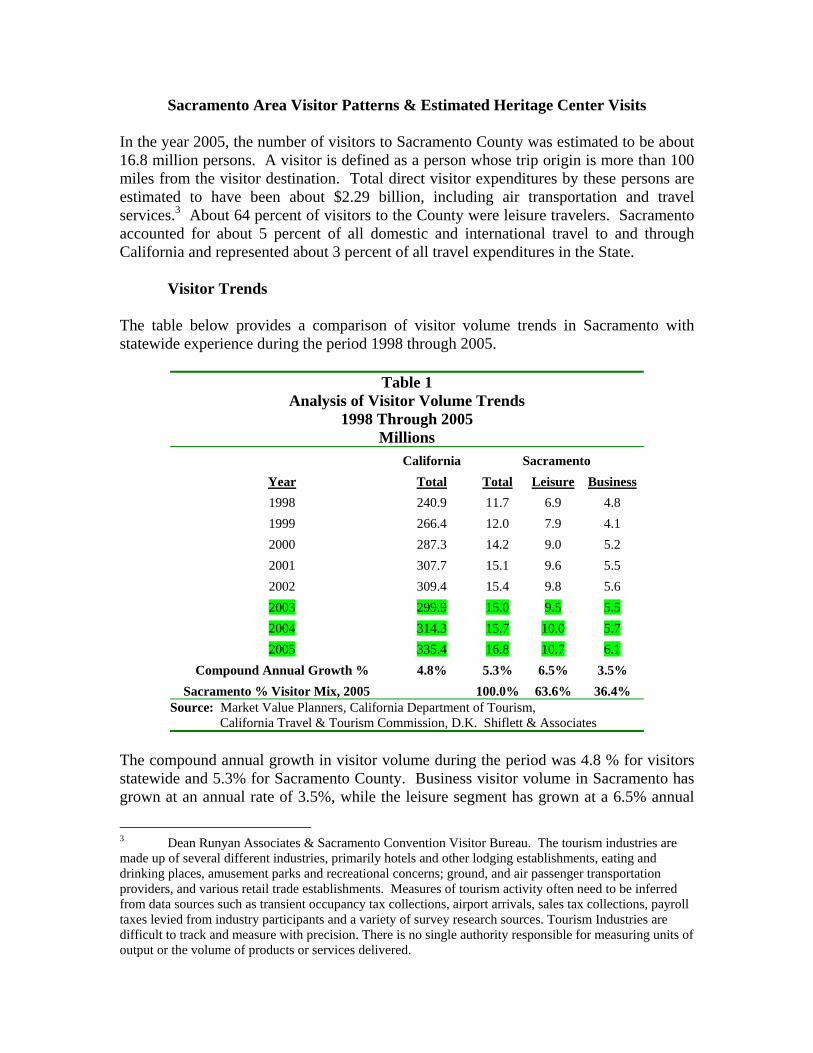
Sacramento Area Visitor Patterns & Estimated Heritage Center Visits In the year 2005, the number of visitors to Sacramento County was estimated to be about 16.8 million persons. A visitor is defined as a person whose trip origin is more than 100 miles from the visitor destination. Total direct visitor expenditures by these persons are estimated to have been about $2.29 billion, including air transportation and travel services.3 About 64 percent of visitors to the County were leisure travelers. Sacramento accounted for about 5 percent of all domestic and international travel to and through California and represented about 3 percent of all travel expenditures in the State.
Visitor Trends The table below provides a comparison of visitor volume trends in Sacramento with statewide experience during the period 1998 through 2005.
Table 1 Analysis of Visitor Volume Trends
1998 Through 2005 Millions
California Sacramento Year Total Total Leisure Business 1998 240.9 11.7 6.9 4.8 1999 266.4 12.0 7.9 4.1 2000 287.3 14.2 9.0 5.2 2001 307.7 15.1 9.6 5.5 2002 309.4 15.4 9.8 5.6 2003 299.9 15.0 9.5 5.5 2004 314.3 15.7 10.0 5.7 2005 335.4 16.8 10.7 6.1
Compound Annual Growth % 4.8% 5.3% 6.5% 3.5% Sacramento % Visitor Mix, 2005 100.0% 63.6% 36.4% Source: Market Value Planners, California Department of Tourism, California Travel & Tourism Commission, D.K. Shiflett & Associates
The compound annual growth in visitor volume during the period was 4.8 % for visitors statewide and 5.3% for Sacramento County. Business visitor volume in Sacramento has grown at an annual rate of 3.5%, while the leisure segment has grown at a 6.5% annual
3 Dean Runyan Associates & Sacramento Convention Visitor Bureau. The tourism industries are made up of several different industries, primarily hotels and other lodging establishments, eating and drinking places, amusement parks and recreational concerns; ground, and air passenger transportation providers, and various retail trade establishments. Measures of tourism activity often need to be inferred from data sources such as transient occupancy tax collections, airport arrivals, sales tax collections, payroll taxes levied from industry participants and a variety of survey research sources. Tourism Industries are difficult to track and measure with precision. There is no single authority responsible for measuring units of output or the volume of products or services delivered.
Visitor Patterns & Estimated CHC Annual Visits Page - 7
Market Value Planners
rate. The highlighted lines in Table 1 represent the updated data to this report, which indicates a continued pattern of faster visitor volume growth in the Sacramento area than in the State overall. The period 2001 through 2002 was one of general economic downturn, shocked further by the events of September 11th, yet California visitor trips showed a modest increase of 0.6% overall, while visitor volume in Sacramento County increased by nearly 2%, during this period. The Travel Industry Association of America reports that during this period non-resident leisure travel to and through California declined by approximately 7% while resident leisure travel within the state increased by slightly more than 8%, as travelers opted for closer to home, shorter trips by automobile. The Sacramento area appears to have captured more than its proportionate share of visitor volume resulting from this shift toward closer to home shorter trips by resident travelers. It is now ranked as the fifth largest visitor destination within the state.4
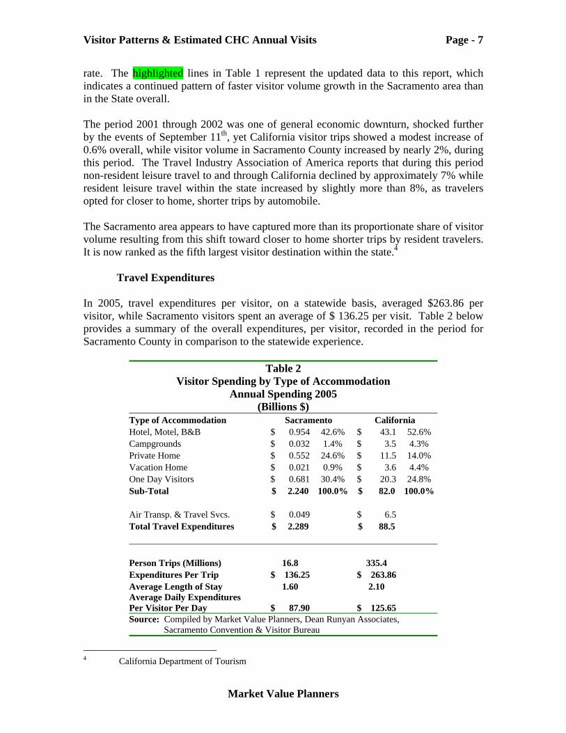
Travel Expenditures In 2005, travel expenditures per visitor, on a statewide basis, averaged $263.86 per visitor, while Sacramento visitors spent an average of $ 136.25 per visit. Table 2 below provides a summary of the overall expenditures, per visitor, recorded in the period for Sacramento County in comparison to the statewide experience.
Table 2 Visitor Spending by Type of Accommodation
Annual Spending 2005 (Billions $)
Type of Accommodation Sacramento California Hotel, Motel, B&B $ 0.954 42.6% $ 43.1 52.6% Campgrounds $ 0.032 1.4% $ 3.5 4.3% Private Home $ 0.552 24.6% $ 11.5 14.0% Vacation Home $ 0.021 0.9% $ 3.6 4.4% One Day Visitors $ 0.681 30.4% $ 20.3 24.8% Sub-Total $ 2.240 100.0% $ 82.0 100.0% Air Transp. & Travel Svcs. $ 0.049 $ 6.5 Total Travel Expenditures $ 2.289 $ 88.5 Person Trips (Millions) 16.8 335.4 Expenditures Per Trip $ 136.25 $ 263.86 Average Length of Stay 1.60 2.10 Average Daily Expenditures Per Visitor Per Day $ 87.90 $ 125.65 Source: Compiled by Market Value Planners, Dean Runyan Associates, Sacramento Convention & Visitor Bureau
4 California Department of Tourism
Visitor Patterns & Estimated CHC Annual Visits Page - 8
Market Value Planners
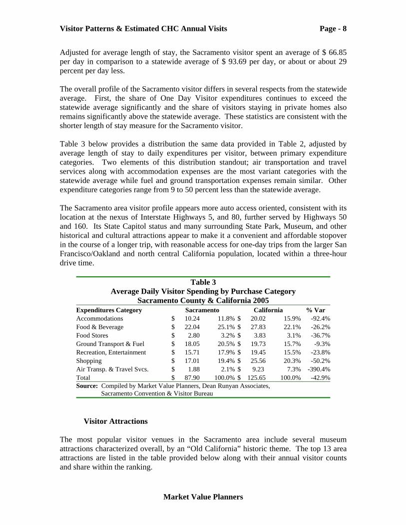
Adjusted for average length of stay, the Sacramento visitor spent an average of $ 66.85 per day in comparison to a statewide average of $ 93.69 per day, or about or about 29 percent per day less. The overall profile of the Sacramento visitor differs in several respects from the statewide average. First, the share of One Day Visitor expenditures continues to exceed the statewide average significantly and the share of visitors staying in private homes also remains significantly above the statewide average. These statistics are consistent with the shorter length of stay measure for the Sacramento visitor. Table 3 below provides a distribution the same data provided in Table 2, adjusted by average length of stay to daily expenditures per visitor, between primary expenditure categories. Two elements of this distribution standout; air transportation and travel services along with accommodation expenses are the most variant categories with the statewide average while fuel and ground transportation expenses remain similar. Other expenditure categories range from 9 to 50 percent less than the statewide average. The Sacramento area visitor profile appears more auto access oriented, consistent with its location at the nexus of Interstate Highways 5, and 80, further served by Highways 50 and 160. Its State Capitol status and many surrounding State Park, Museum, and other historical and cultural attractions appear to make it a convenient and affordable stopover in the course of a longer trip, with reasonable access for one-day trips from the larger San Francisco/Oakland and north central California population, located within a three-hour drive time.
Table 3 Average Daily Visitor Spending by Purchase Category
Sacramento County & California 2005 Expenditures Category Sacramento California % Var Accommodations $ 10.24 11.8% $ 20.02 15.9% -92.4%Food & Beverage $ 22.04 25.1% $ 27.83 22.1% -26.2%Food Stores $ 2.80 3.2% $ 3.83 3.1% -36.7%Ground Transport & Fuel $ 18.05 20.5% $ 19.73 15.7% -9.3%Recreation, Entertainment $ 15.71 17.9% $ 19.45 15.5% -23.8%Shopping $ 17.01 19.4% $ 25.56 20.3% -50.2%Air Transp. & Travel Svcs. $ 1.88 2.1% $ 9.23 7.3% -390.4%Total $ 87.90 100.0% $ 125.65 100.0% -42.9%Source: Compiled by Market Value Planners, Dean Runyan Associates, Sacramento Convention & Visitor Bureau
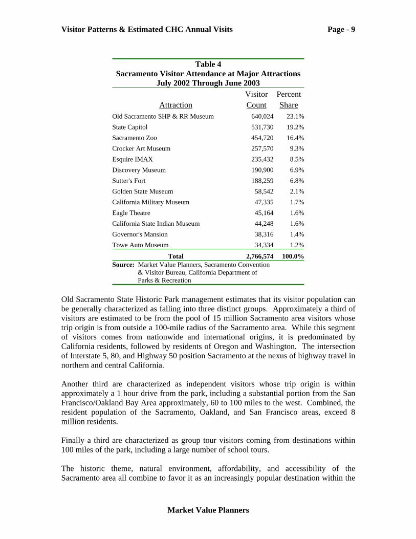
Visitor Attractions The most popular visitor venues in the Sacramento area include several museum attractions characterized overall, by an “Old California” historic theme. The top 13 area attractions are listed in the table provided below along with their annual visitor counts and share within the ranking.
Visitor Patterns & Estimated CHC Annual Visits Page - 9
Market Value Planners
Table 4
Sacramento Visitor Attendance at Major Attractions July 2002 Through June 2003
Visitor Percent Attraction Count Share
Old Sacramento SHP & RR Museum 640,024 23.1%State Capitol 531,730 19.2%Sacramento Zoo 454,720 16.4%Crocker Art Museum 257,570 9.3%Esquire IMAX 235,432 8.5%Discovery Museum 190,900 6.9%Sutter's Fort 188,259 6.8%Golden State Museum 58,542 2.1%California Military Museum 47,335 1.7%Eagle Theatre 45,164 1.6%California State Indian Museum 44,248 1.6%Governor's Mansion 38,316 1.4%Towe Auto Museum 34,334 1.2%
Total 2,766,574 100.0%Source: Market Value Planners, Sacramento Convention & Visitor Bureau, California Department of Parks & Recreation
Old Sacramento State Historic Park management estimates that its visitor population can be generally characterized as falling into three distinct groups. Approximately a third of visitors are estimated to be from the pool of 15 million Sacramento area visitors whose trip origin is from outside a 100-mile radius of the Sacramento area. While this segment of visitors comes from nationwide and international origins, it is predominated by California residents, followed by residents of Oregon and Washington. The intersection of Interstate 5, 80, and Highway 50 position Sacramento at the nexus of highway travel in northern and central California. Another third are characterized as independent visitors whose trip origin is within approximately a 1 hour drive from the park, including a substantial portion from the San Francisco/Oakland Bay Area approximately, 60 to 100 miles to the west. Combined, the resident population of the Sacramento, Oakland, and San Francisco areas, exceed 8 million residents. Finally a third are characterized as group tour visitors coming from destinations within 100 miles of the park, including a large number of school tours. The historic theme, natural environment, affordability, and accessibility of the Sacramento area all combine to favor it as an increasingly popular destination within the
Visitor Patterns & Estimated CHC Annual Visits Page - 10
Market Value Planners
California visitor market. It is well aligned with several of the key trends emerging in the travel industries. For example, a recent travel industry survey reveals that 27% of U.S. travelers included a visit to a museum or historic place on their itinerary, while 17% included a cultural event or festival on their trip. Combined, 33% of all travelers included an historic place or cultural event visit in their trip.5
The Learning Vacation In recent years a resurgence of interest has occurred in an approach first introduced by the Chautauqua Institution, located on the shore of Lake Chautauqua, in up-state New York, during the 1880’s. The popular Chautauqua Institution offered a variety of adult, and children oriented educational programs for couples, families, and individuals in combination with an array of leisure activities. Resident artists provided a diversity of music, theater productions, and lectures throughout the season. A modern day example of the concept is the Disney Institute, which recently opened its 58-acre complex in Orlando, Florida, dedicated to the expanding learning vacation niche, patterned closely after the Chautauqua Institution program. Disney offers an array of 60 classes focused within 8 broad interest categories ranging from ethnic cooking to clay figure animation, and film production to set design, and artificial finishes. A typical guest package includes a three-day stay during which two to three, one to two hour classes are attended each day. Rooms, and food and beverage services, and activities are included in each package. Another popular current example of the learning vacation concept is the Elderhostel program, designed for persons over 55, and providing a blend of recreation and light academic programs in a wide variety of subject interests. Programs are offered on a year-round basis but most are presented during the summer months and often use college and university campus facilities to house guests and conduct classes. The CIHC concept is well aligned with these increasingly popular approaches to meeting the needs of area visitors. Few opportunities are available for knowledgeable and active visitors to experience the natural, cultural, spiritual, and scenic variety of California and its native people. An accessible offering of the scale, depth, and continuity of the CIHC concept, could be expected to compete at a high level of penetration into the existing and emerging visitor market in the Sacramento area and draw heavily from its surrounding northern and central California population centers for the shorter the One Day independent and group visitor segments.
Seasonality of Visits Sacramento area visitor patterns are highly seasonal, peaking in the summer months of July and August, and falling off during the early weeks of September reaching their lowest levels during the winter period of December through February. Sacramento’s overall visitor volume pattern tends to mirror the pattern of its weather, along with the 5 Western Association of Convention Visitor Bureaus (WACVB), “Tourism in the 21st Century”.
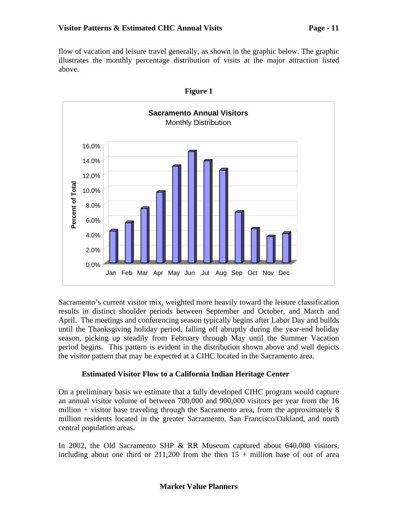
Visitor Patterns & Estimated CHC Annual Visits Page - 11
Market Value Planners
flow of vacation and leisure travel generally, as shown in the graphic below. The graphic illustrates the monthly percentage distribution of visits at the major attraction listed above.
Figure 1
0.0%
2.0%
4.0%
6.0%
8.0%
10.0%
12.0%
14.0%
16.0%
Perc
ent o
f Tot
al
Jan Feb Mar Apr May Jun Jul Aug Sep Oct Nov Dec
Sacramento Annual VisitorsMonthly Distribution
Sacramento’s current visitor mix, weighted more heavily toward the leisure classification results in distinct shoulder periods between September and October, and March and April. The meetings and conferencing season typically begins after Labor Day and builds until the Thanksgiving holiday period, falling off abruptly during the year-end holiday season, picking up steadily from February through May until the Summer Vacation period begins. This pattern is evident in the distribution shown above and well depicts the visitor pattern that may be expected at a CIHC located in the Sacramento area.
Estimated Visitor Flow to a California Indian Heritage Center On a preliminary basis we estimate that a fully developed CIHC program would capture an annual visitor volume of between 700,000 and 900,000 visitors per year from the 16 million + visitor base traveling through the Sacramento area, from the approximately 8 million residents located in the greater Sacramento, San Francisco/Oakland, and north central population areas. In 2002, the Old Sacramento SHP & RR Museum captured about 640,000 visitors, including about one third or 211,200 from the then 15 + million base of out of area
Visitor Patterns & Estimated CHC Annual Visits Page - 12
Market Value Planners
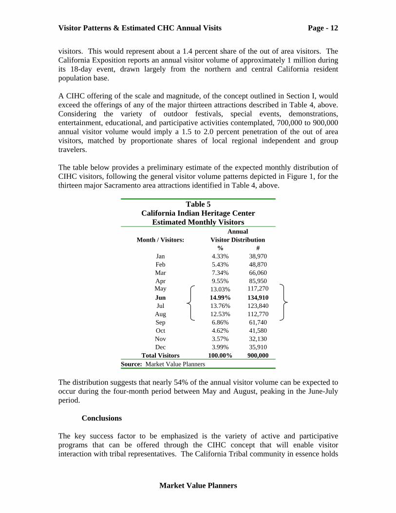
visitors. This would represent about a 1.4 percent share of the out of area visitors. The California Exposition reports an annual visitor volume of approximately 1 million during its 18-day event, drawn largely from the northern and central California resident population base. A CIHC offering of the scale and magnitude, of the concept outlined in Section I, would exceed the offerings of any of the major thirteen attractions described in Table 4, above. Considering the variety of outdoor festivals, special events, demonstrations, entertainment, educational, and participative activities contemplated, 700,000 to 900,000 annual visitor volume would imply a 1.5 to 2.0 percent penetration of the out of area visitors, matched by proportionate shares of local regional independent and group travelers. The table below provides a preliminary estimate of the expected monthly distribution of CIHC visitors, following the general visitor volume patterns depicted in Figure 1, for the thirteen major Sacramento area attractions identified in Table 4, above.
Table 5 California Indian Heritage Center
Estimated Monthly Visitors Annual
Month / Visitors: Visitor Distribution % #
Jan 4.33% 38,970 Feb 5.43% 48,870 Mar 7.34% 66,060 Apr 9.55% 85,950 May 13.03% 117,270 Jun 14.99% 134,910 Jul 13.76% 123,840
Aug 12.53% 112,770 Sep 6.86% 61,740 Oct 4.62% 41,580 Nov 3.57% 32,130 Dec 3.99% 35,910
Total Visitors 100.00% 900,000 Source: Market Value Planners
The distribution suggests that nearly 54% of the annual visitor volume can be expected to occur during the four-month period between May and August, peaking in the June-July period.
Conclusions The key success factor to be emphasized is the variety of active and participative programs that can be offered through the CIHC concept that will enable visitor interaction with tribal representatives. The California Tribal community in essence holds
Visitor Patterns & Estimated CHC Annual Visits Page - 13
Market Value Planners
the franchise on its cultural and natural resource relationships. The Tribes are the most legitimate interpreters, guides, and presenters of their natural and cultural history. The Sacramento area could be a viable location for the CIHC given its excellent highway access and air travel infrastructure. It is one of the fastest growing visitor centers in California and is quite centrally located within the state with a relatively affordable hosting capacity of other aligned attractions, lodging, and other visitor services. Our opinion is that a fully developed CIHC concept offering, including the full range of indoor and outdoor space uses, as summarized below, could attract an annual visitor volume of between 700,000 and 900,000 visitors per year. Travelers to and visitors within California have ample opportunities to take scenic drives through redwood groves, down coastal roads, through desert landscape, and past scenic rivers. And many opportunities are available to view museum exhibits and displays of every type and kind. To the extent that land and culture are inseparable, a full appreciation of either requires a holistic view of both. Few opportunities are available to have the stories of land, culture and spiritual renewal told directly, in the first person, by legitimate practitioners and presenters. In order for the CIHC to achieve its full potential the California Tribes must assume the ultimate leadership responsibility of host and educator.
Section III Conceptual Level Construction Cost Estimates
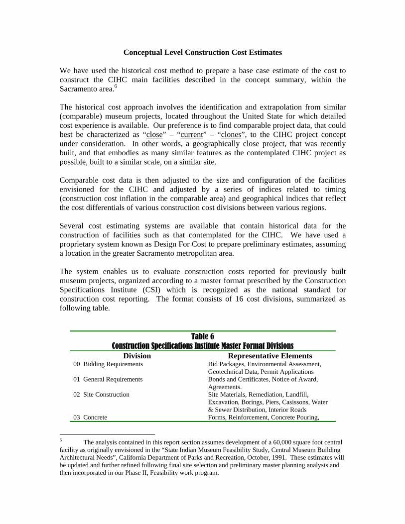
Conceptual Level Construction Cost Estimates We have used the historical cost method to prepare a base case estimate of the cost to construct the CIHC main facilities described in the concept summary, within the Sacramento area.6 The historical cost approach involves the identification and extrapolation from similar (comparable) museum projects, located throughout the United State for which detailed cost experience is available. Our preference is to find comparable project data, that could best be characterized as “close” – “current” – “clones”, to the CIHC project concept under consideration. In other words, a geographically close project, that was recently built, and that embodies as many similar features as the contemplated CIHC project as possible, built to a similar scale, on a similar site. Comparable cost data is then adjusted to the size and configuration of the facilities envisioned for the CIHC and adjusted by a series of indices related to timing (construction cost inflation in the comparable area) and geographical indices that reflect the cost differentials of various construction cost divisions between various regions. Several cost estimating systems are available that contain historical data for the construction of facilities such as that contemplated for the CIHC. We have used a proprietary system known as Design For Cost to prepare preliminary estimates, assuming a location in the greater Sacramento metropolitan area. The system enables us to evaluate construction costs reported for previously built museum projects, organized according to a master format prescribed by the Construction Specifications Institute (CSI) which is recognized as the national standard for construction cost reporting. The format consists of 16 cost divisions, summarized as following table.
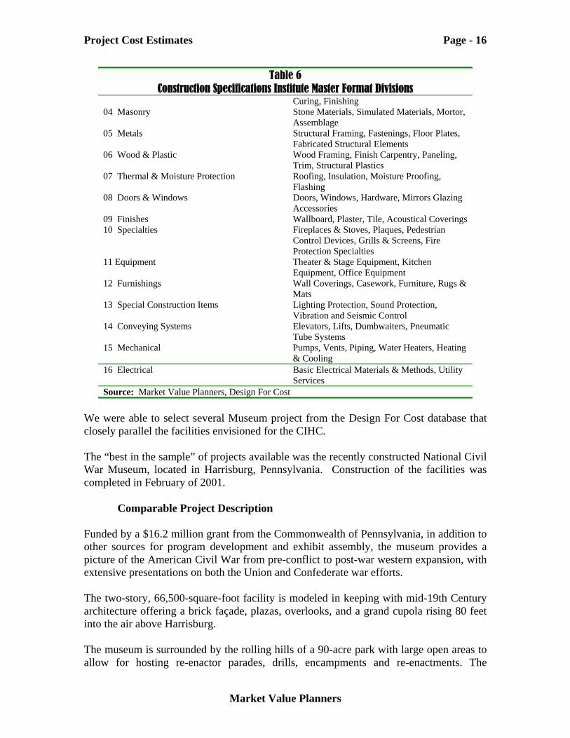
Table 6 Construction Specifications Institute Master Format Divisions
Division Representative Elements 00 Bidding Requirements Bid Packages, Environmental Assessment,
Geotechnical Data, Permit Applications 01 General Requirements Bonds and Certificates, Notice of Award,
Agreements. 02 Site Construction Site Materials, Remediation, Landfill,
Excavation, Borings, Piers, Casissons, Water & Sewer Distribution, Interior Roads
03 Concrete Forms, Reinforcement, Concrete Pouring,
6 The analysis contained in this report section assumes development of a 60,000 square foot central facility as originally envisioned in the “State Indian Museum Feasibility Study, Central Museum Building Architectural Needs”, California Department of Parks and Recreation, October, 1991. These estimates will be updated and further refined following final site selection and preliminary master planning analysis and then incorporated in our Phase II, Feasibility work program.
Project Cost Estimates Page - 16
Market Value Planners
Table 6 Construction Specifications Institute Master Format Divisions
Curing, Finishing 04 Masonry Stone Materials, Simulated Materials, Mortor,
Assemblage 05 Metals Structural Framing, Fastenings, Floor Plates,
Fabricated Structural Elements 06 Wood & Plastic Wood Framing, Finish Carpentry, Paneling,
Trim, Structural Plastics 07 Thermal & Moisture Protection Roofing, Insulation, Moisture Proofing,
Flashing 08 Doors & Windows Doors, Windows, Hardware, Mirrors Glazing
Accessories 09 Finishes Wallboard, Plaster, Tile, Acoustical Coverings 10 Specialties Fireplaces & Stoves, Plaques, Pedestrian
Control Devices, Grills & Screens, Fire Protection Specialties
11 Equipment Theater & Stage Equipment, Kitchen Equipment, Office Equipment
12 Furnishings Wall Coverings, Casework, Furniture, Rugs & Mats
13 Special Construction Items Lighting Protection, Sound Protection, Vibration and Seismic Control
14 Conveying Systems Elevators, Lifts, Dumbwaiters, Pneumatic Tube Systems
15 Mechanical Pumps, Vents, Piping, Water Heaters, Heating & Cooling
16 Electrical Basic Electrical Materials & Methods, Utility Services
Source: Market Value Planners, Design For Cost We were able to select several Museum project from the Design For Cost database that closely parallel the facilities envisioned for the CIHC. The “best in the sample” of projects available was the recently constructed National Civil War Museum, located in Harrisburg, Pennsylvania. Construction of the facilities was completed in February of 2001.
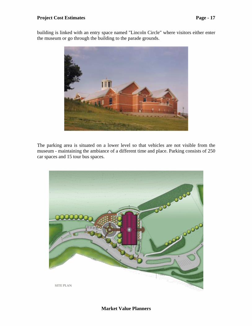
Comparable Project Description Funded by a $16.2 million grant from the Commonwealth of Pennsylvania, in addition to other sources for program development and exhibit assembly, the museum provides a picture of the American Civil War from pre-conflict to post-war western expansion, with extensive presentations on both the Union and Confederate war efforts. The two-story, 66,500-square-foot facility is modeled in keeping with mid-19th Century architecture offering a brick façade, plazas, overlooks, and a grand cupola rising 80 feet into the air above Harrisburg. The museum is surrounded by the rolling hills of a 90-acre park with large open areas to allow for hosting re-enactor parades, drills, encampments and re-enactments. The
Project Cost Estimates Page - 17
Market Value Planners
building is linked with an entry space named "Lincoln Circle" where visitors either enter the museum or go through the building to the parade grounds.
The parking area is situated on a lower level so that vehicles are not visible from the museum - maintaining the ambiance of a different time and place. Parking consists of 250 car spaces and 15 tour bus spaces.
Project Cost Estimates Page - 18
Market Value Planners
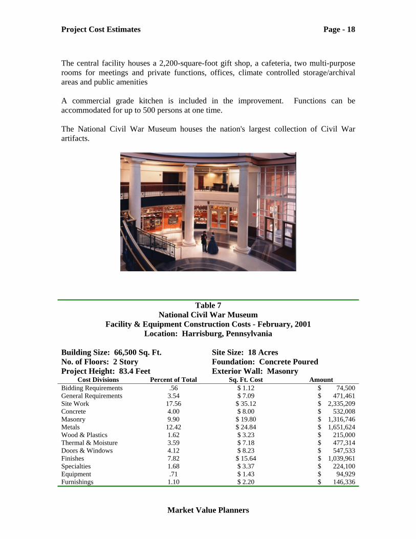
The central facility houses a 2,200-square-foot gift shop, a cafeteria, two multi-purpose rooms for meetings and private functions, offices, climate controlled storage/archival areas and public amenities A commercial grade kitchen is included in the improvement. Functions can be accommodated for up to 500 persons at one time. The National Civil War Museum houses the nation's largest collection of Civil War artifacts.
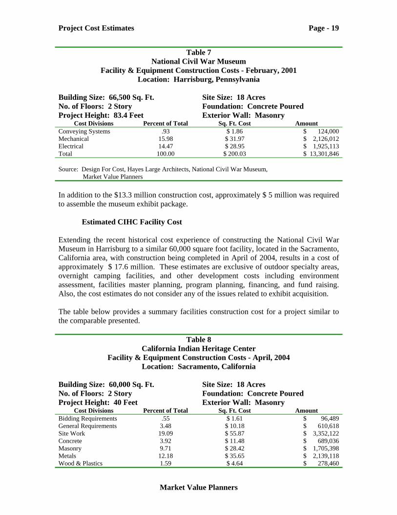
Table 7 National Civil War Museum
Facility & Equipment Construction Costs - February, 2001 Location: Harrisburg, Pennsylvania
Building Size: 66,500 Sq. Ft. No. of Floors: 2 Story Project Height: 83.4 Feet
Site Size: 18 Acres Foundation: Concrete Poured Exterior Wall: Masonry
Cost Divisions Percent of Total Sq. Ft. Cost Amount Bidding Requirements .56 $ 1.12 $ 74,500 General Requirements 3.54 $ 7.09 $ 471,461 Site Work 17.56 $ 35.12 $ 2,335,209 Concrete 4.00 $ 8.00 $ 532,008 Masonry 9.90 $ 19.80 $ 1,316,746 Metals 12.42 $ 24.84 $ 1,651,624 Wood & Plastics 1.62 $ 3.23 $ 215,000 Thermal & Moisture 3.59 $ 7.18 $ 477,314 Doors & Windows 4.12 $ 8.23 $ 547,533 Finishes 7.82 $ 15.64 $ 1,039,961 Specialties 1.68 $ 3.37 $ 224,100 Equipment .71 $ 1.43 $ 94,929 Furnishings 1.10 $ 2.20 $ 146,336
Project Cost Estimates Page - 19
Market Value Planners
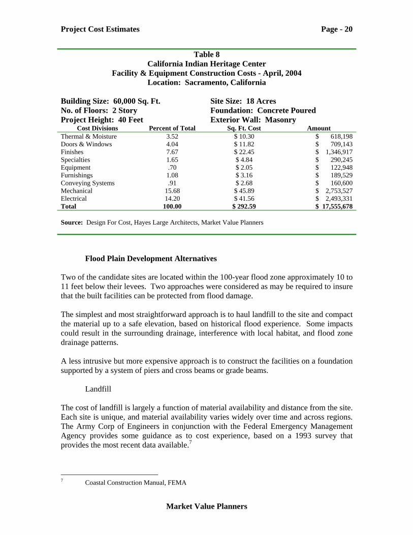
Table 7 National Civil War Museum
Facility & Equipment Construction Costs - February, 2001 Location: Harrisburg, Pennsylvania
Building Size: 66,500 Sq. Ft. No. of Floors: 2 Story Project Height: 83.4 Feet
Site Size: 18 Acres Foundation: Concrete Poured Exterior Wall: Masonry
Cost Divisions Percent of Total Sq. Ft. Cost Amount Conveying Systems .93 $ 1.86 $ 124,000 Mechanical 15.98 $ 31.97 $ 2,126,012 Electrical 14.47 $ 28.95 $ 1,925,113 Total 100.00 $ 200.03 $ 13,301,846 Source: Design For Cost, Hayes Large Architects, National Civil War Museum, Market Value Planners In addition to the $13.3 million construction cost, approximately $ 5 million was required to assemble the museum exhibit package.
Estimated CIHC Facility Cost Extending the recent historical cost experience of constructing the National Civil War Museum in Harrisburg to a similar 60,000 square foot facility, located in the Sacramento, California area, with construction being completed in April of 2004, results in a cost of approximately $ 17.6 million. These estimates are exclusive of outdoor specialty areas, overnight camping facilities, and other development costs including environment assessment, facilities master planning, program planning, financing, and fund raising. Also, the cost estimates do not consider any of the issues related to exhibit acquisition. The table below provides a summary facilities construction cost for a project similar to the comparable presented.
Table 8 California Indian Heritage Center
Facility & Equipment Construction Costs - April, 2004 Location: Sacramento, California
Building Size: 60,000 Sq. Ft. No. of Floors: 2 Story Project Height: 40 Feet
Site Size: 18 Acres Foundation: Concrete Poured Exterior Wall: Masonry
Cost Divisions Percent of Total Sq. Ft. Cost Amount Bidding Requirements .55 $ 1.61 $ 96,489 General Requirements 3.48 $ 10.18 $ 610,618 Site Work 19.09 $ 55.87 $ 3,352,122 Concrete 3.92 $ 11.48 $ 689,036 Masonry 9.71 $ 28.42 $ 1,705,398 Metals 12.18 $ 35.65 $ 2,139,118 Wood & Plastics 1.59 $ 4.64 $ 278,460
Project Cost Estimates Page - 20
Market Value Planners
Table 8 California Indian Heritage Center
Facility & Equipment Construction Costs - April, 2004 Location: Sacramento, California
Building Size: 60,000 Sq. Ft. No. of Floors: 2 Story Project Height: 40 Feet
Site Size: 18 Acres Foundation: Concrete Poured Exterior Wall: Masonry
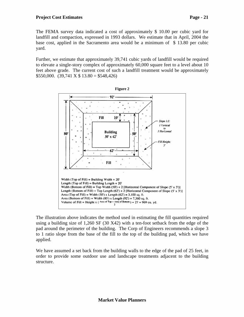
Cost Divisions Percent of Total Sq. Ft. Cost Amount Thermal & Moisture 3.52 $ 10.30 $ 618,198 Doors & Windows 4.04 $ 11.82 $ 709,143 Finishes 7.67 $ 22.45 $ 1,346,917 Specialties 1.65 $ 4.84 $ 290,245 Equipment .70 $ 2.05 $ 122,948 Furnishings 1.08 $ 3.16 $ 189,529 Conveying Systems .91 $ 2.68 $ 160,600 Mechanical 15.68 $ 45.89 $ 2,753,527 Electrical 14.20 $ 41.56 $ 2,493,331 Total 100.00 $ 292.59 $ 17,555,678 Source: Design For Cost, Hayes Large Architects, Market Value Planners
Flood Plain Development Alternatives Two of the candidate sites are located within the 100-year flood zone approximately 10 to 11 feet below their levees. Two approaches were considered as may be required to insure that the built facilities can be protected from flood damage. The simplest and most straightforward approach is to haul landfill to the site and compact the material up to a safe elevation, based on historical flood experience. Some impacts could result in the surrounding drainage, interference with local habitat, and flood zone drainage patterns. A less intrusive but more expensive approach is to construct the facilities on a foundation supported by a system of piers and cross beams or grade beams.
Landfill
The cost of landfill is largely a function of material availability and distance from the site. Each site is unique, and material availability varies widely over time and across regions. The Army Corp of Engineers in conjunction with the Federal Emergency Management Agency provides some guidance as to cost experience, based on a 1993 survey that provides the most recent data available.7
7 Coastal Construction Manual, FEMA
Project Cost Estimates Page - 21
Market Value Planners
The FEMA survey data indicated a cost of approximately $ 10.00 per cubic yard for landfill and compaction, expressed in 1993 dollars. We estimate that in April, 2004 the base cost, applied in the Sacramento area would be a minimum of $ 13.80 per cubic yard. Further, we estimate that approximately 39,741 cubic yards of landfill would be required to elevate a single-story complex of approximately 60,000 square feet to a level about 10 feet above grade. The current cost of such a landfill treatment would be approximately $550,000. (39,741 X $ 13.80 = $548,426)
Figure 2
The illustration above indicates the method used in estimating the fill quantities required using a building size of 1,260 SF (30 X42) with a ten-foot setback from the edge of the pad around the perimeter of the building. The Corp of Engineers recommends a slope 3 to 1 ratio slope from the base of the fill to the top of the building pad, which we have applied. We have assumed a set back from the building walls to the edge of the pad of 25 feet, in order to provide some outdoor use and landscape treatments adjacent to the building structure.
Project Cost Estimates Page - 22
Market Value Planners
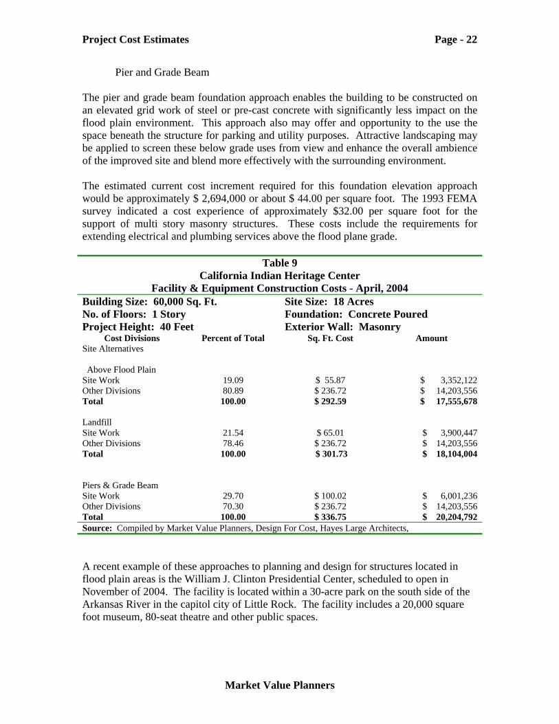
Pier and Grade Beam The pier and grade beam foundation approach enables the building to be constructed on an elevated grid work of steel or pre-cast concrete with significantly less impact on the flood plain environment. This approach also may offer and opportunity to the use the space beneath the structure for parking and utility purposes. Attractive landscaping may be applied to screen these below grade uses from view and enhance the overall ambience of the improved site and blend more effectively with the surrounding environment. The estimated current cost increment required for this foundation elevation approach would be approximately $ 2,694,000 or about $ 44.00 per square foot. The 1993 FEMA survey indicated a cost experience of approximately $32.00 per square foot for the support of multi story masonry structures. These costs include the requirements for extending electrical and plumbing services above the flood plane grade.
Table 9 California Indian Heritage Center
Facility & Equipment Construction Costs - April, 2004 Building Size: 60,000 Sq. Ft. No. of Floors: 1 Story Project Height: 40 Feet
Site Size: 18 Acres Foundation: Concrete Poured Exterior Wall: Masonry
Cost Divisions Percent of Total Sq. Ft. Cost Amount Site Alternatives Above Flood Plain Site Work 19.09 $ 55.87 $ 3,352,122 Other Divisions 80.89 $ 236.72 $ 14,203,556 Total 100.00 $ 292.59 $ 17,555,678 Landfill Site Work 21.54 $ 65.01 $ 3,900,447 Other Divisions 78.46 $ 236.72 $ 14,203,556 Total 100.00 $ 301.73 $ 18,104,004 Piers & Grade Beam Site Work 29.70 $ 100.02 $ 6,001,236 Other Divisions 70.30 $ 236.72 $ 14,203,556 Total 100.00 $ 336.75 $ 20,204,792 Source: Compiled by Market Value Planners, Design For Cost, Hayes Large Architects, A recent example of these approaches to planning and design for structures located in flood plain areas is the William J. Clinton Presidential Center, scheduled to open in November of 2004. The facility is located within a 30-acre park on the south side of the Arkansas River in the capitol city of Little Rock. The facility includes a 20,000 square foot museum, 80-seat theatre and other public spaces.
Project Cost Estimates Page - 23
Market Value Planners
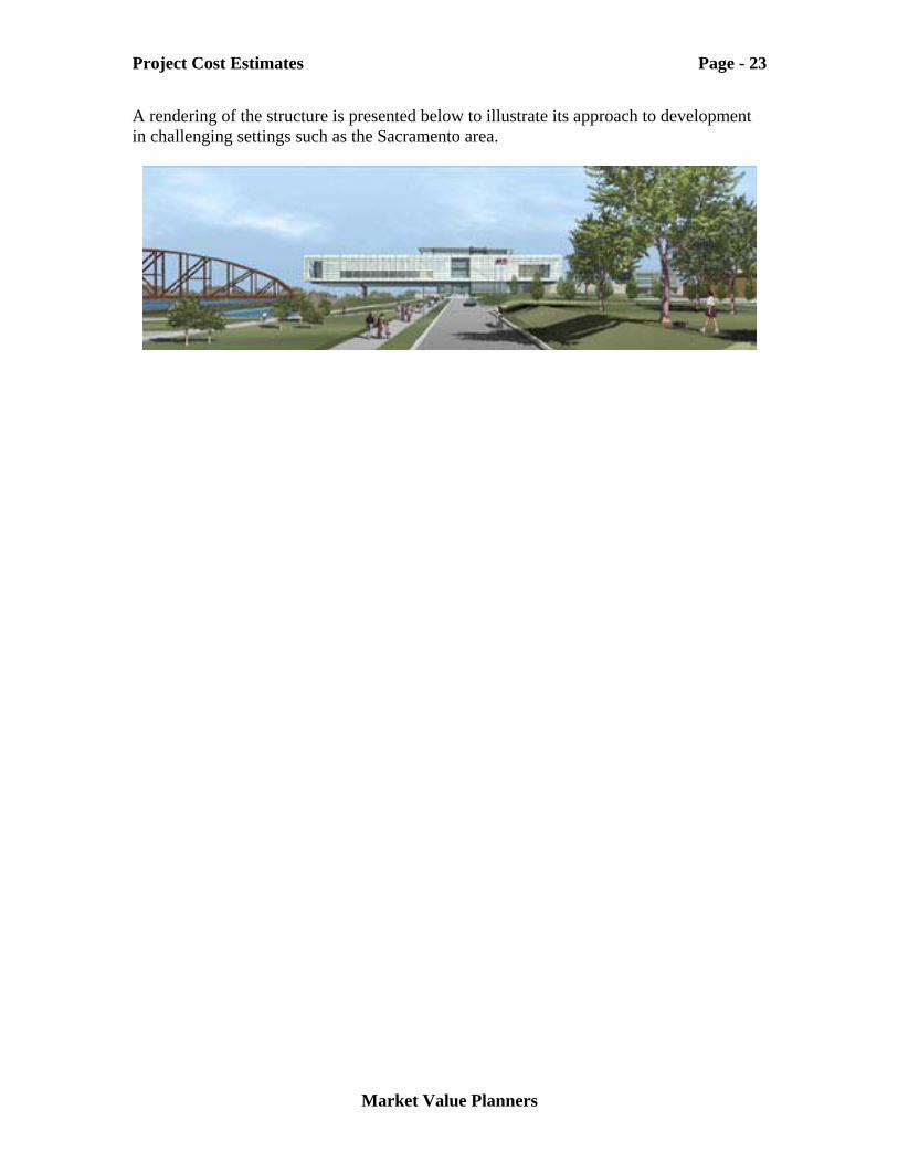
A rendering of the structure is presented below to illustrate its approach to development in challenging settings such as the Sacramento area.

Section IV Site Evaluations
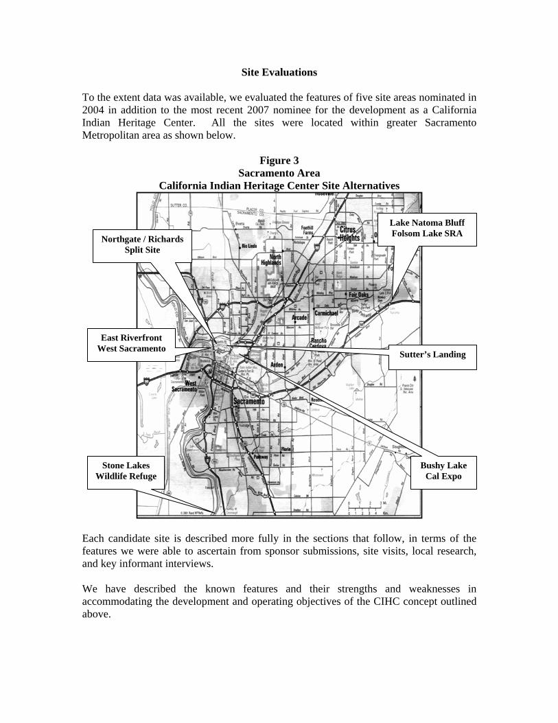
Site Evaluations To the extent data was available, we evaluated the features of five site areas nominated in 2004 in addition to the most recent 2007 nominee for the development as a California Indian Heritage Center. All the sites were located within greater Sacramento Metropolitan area as shown below.
Figure 3 Sacramento Area
California Indian Heritage Center Site Alternatives
Each candidate site is described more fully in the sections that follow, in terms of the features we were able to ascertain from sponsor submissions, site visits, local research, and key informant interviews. We have described the known features and their strengths and weaknesses in accommodating the development and operating objectives of the CIHC concept outlined above.
Northgate / Richards Split Site
Sutter’s Landing
Stone Lakes Wildlife Refuge
Lake Natoma Bluff Folsom Lake SRA
Bushy Lake Cal Expo
East Riverfront West Sacramento
Site Evaluations Page - 26
Market Value Planners
Elements of Comparison To the extent possible, each site has been evaluated on the basis of the comparative elements summarized in the follows.
Site Features
Size of specifically designated use areas for the CIHC facilities and improved use areas
Topography description including, slope, view features from areas
designated for facilities development, vegetation, and other existing landscape features
Internal roadways necessary to accommodate anticipated visitor volume
Flood hazard FEMA zone classification (insurable features) and
impact on development costs
Earthquake zone documentation
Soil conditions of designated areas within the site and ability to
support concept plan structural improvements in terms bearing capacity
Seasonal weather condition, eg. degree days, average days of sunshine, annual rainfall, etc.
Proximity to potentially adverse conditions such as noise, odors, traffic
congestion, airport flight paths, night lighting.
Infrastructure
Water sources for potable and irrigation purposes;
Sewerage treatment capacity available, eg., gallons per day, or alternatives proposed
Transportation Access Capacity, regional and local, up to the site, such
as; Roads, Public Transit, Walkways and Trails.
Power
Site Evaluations Page - 27
Market Value Planners
Communications.
Legal, Land Planning, and Administrative Attributes
Current zoning classifications of designated area(s) and identification of
planning/permitting authorities;
Applicable easements, deed restrictions, or continuing entitlements to the specifically identified sites
Estimated land assembly costs
Proposed title conveyance method, such as by fee simple or leasehold position
and conditions which may attach
Current zoning of adjacent properties and prospective land uses. Area Market Attributes and Penetration Estimates
Estimated capture of visitors to the fully developed CIHC offering potential of
the site under consideration.
Generic Space Use Estimates Using the concept and scope ideas contained in the 1991 and 1992 Indian Museum studies, along with the visitor volume estimates contained in Section II of this report we are able to refine the space use requirements of the concept a little further in order to evaluate the relative strengths and weaknesses of the candidate sites in terms of their ability to accommodate the base case CIHC concept. The concept has taken on a character far more encompassing that that of a museum and artifact exhibit center. Its objectives include an active and participative experience of California Indian Culture for native and non-native visitors. The 125,000 square foot main facility containing exhibit rooms, theatres, conferencing, archival, administrative, and other functions, taken alone, could be accommodated on a site of relatively modest size. Urban planning approaches are well advanced to meet the challenges of land scarcity by using high rise buildings, parking structures, people moving apparatus and the like. We recognize that the CIHC concept is a planning challenge that does not lend itself well to traditional urban park planning approaches. The outdoor elements, key to the participative and interactive features of the concept, require space and separation from distinct spaces in order to convey the feeling of resource abundance, in a setting of constant natural renewal through the interaction of land, water, and sky. Several “ideal sites” likely exist in California, but not in accessible,
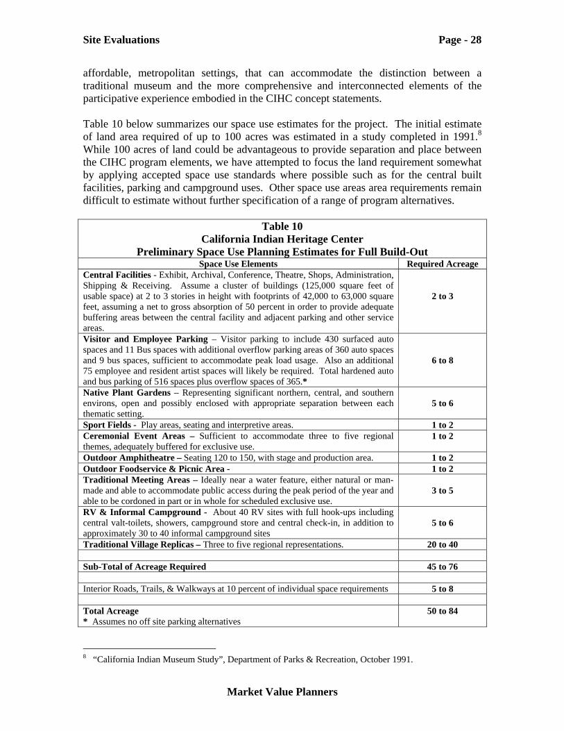
Site Evaluations Page - 28
Market Value Planners
affordable, metropolitan settings, that can accommodate the distinction between a traditional museum and the more comprehensive and interconnected elements of the participative experience embodied in the CIHC concept statements. Table 10 below summarizes our space use estimates for the project. The initial estimate of land area required of up to 100 acres was estimated in a study completed in 1991.8 While 100 acres of land could be advantageous to provide separation and place between the CIHC program elements, we have attempted to focus the land requirement somewhat by applying accepted space use standards where possible such as for the central built facilities, parking and campground uses. Other space use areas area requirements remain difficult to estimate without further specification of a range of program alternatives.
Table 10 California Indian Heritage Center
Preliminary Space Use Planning Estimates for Full Build-Out Space Use Elements Required Acreage
Central Facilities - Exhibit, Archival, Conference, Theatre, Shops, Administration, Shipping & Receiving. Assume a cluster of buildings (125,000 square feet of usable space) at 2 to 3 stories in height with footprints of 42,000 to 63,000 square feet, assuming a net to gross absorption of 50 percent in order to provide adequate buffering areas between the central facility and adjacent parking and other service areas.
2 to 3
Visitor and Employee Parking – Visitor parking to include 430 surfaced auto spaces and 11 Bus spaces with additional overflow parking areas of 360 auto spaces and 9 bus spaces, sufficient to accommodate peak load usage. Also an additional 75 employee and resident artist spaces will likely be required. Total hardened auto and bus parking of 516 spaces plus overflow spaces of 365.*
6 to 8
Native Plant Gardens – Representing significant northern, central, and southern environs, open and possibly enclosed with appropriate separation between each thematic setting.
5 to 6
Sport Fields - Play areas, seating and interpretive areas. 1 to 2 Ceremonial Event Areas – Sufficient to accommodate three to five regional themes, adequately buffered for exclusive use.
1 to 2
Outdoor Amphitheatre – Seating 120 to 150, with stage and production area. 1 to 2 Outdoor Foodservice & Picnic Area - 1 to 2 Traditional Meeting Areas – Ideally near a water feature, either natural or man-made and able to accommodate public access during the peak period of the year and able to be cordoned in part or in whole for scheduled exclusive use.
3 to 5
RV & Informal Campground - About 40 RV sites with full hook-ups including central valt-toilets, showers, campground store and central check-in, in addition to approximately 30 to 40 informal campground sites
5 to 6
Traditional Village Replicas – Three to five regional representations. 20 to 40 Sub-Total of Acreage Required 45 to 76 Interior Roads, Trails, & Walkways at 10 percent of individual space requirements 5 to 8 Total Acreage * Assumes no off site parking alternatives
50 to 84
8 “California Indian Museum Study”, Department of Parks & Recreation, October 1991.
Site Evaluations Page - 29
Market Value Planners
The estimated range of 50 to 80 acres should not to be considered hard, fast and final but is helpful as a guideline for evaluating the potentials of each site considered, where trade-offs may need to be made between a candidate site’s strengths and weaknesses in accommodating the most compelling and comprehensive expression of the CIHC concept. Although a need for up to 100 acres was initially identified, the CIHC Task Force, in their solicitation for sites, allowed for a minimum of 25 acres, if nearby available sites could be used to accommodate outdoor activities.
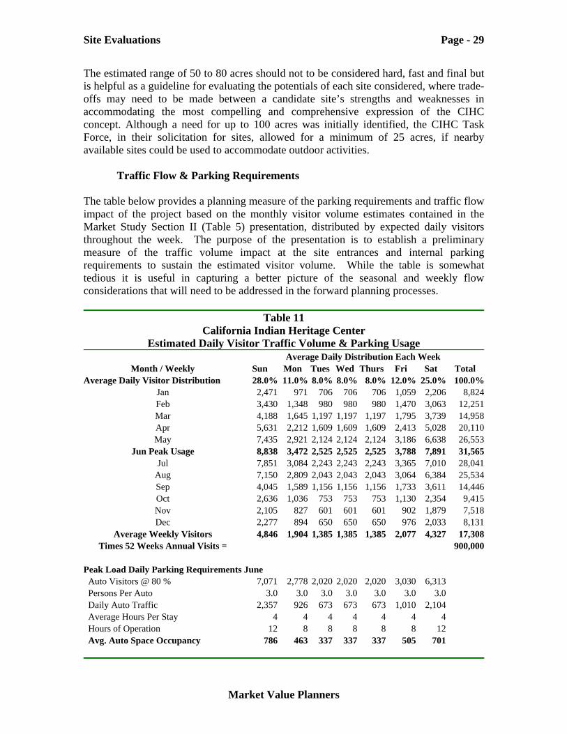
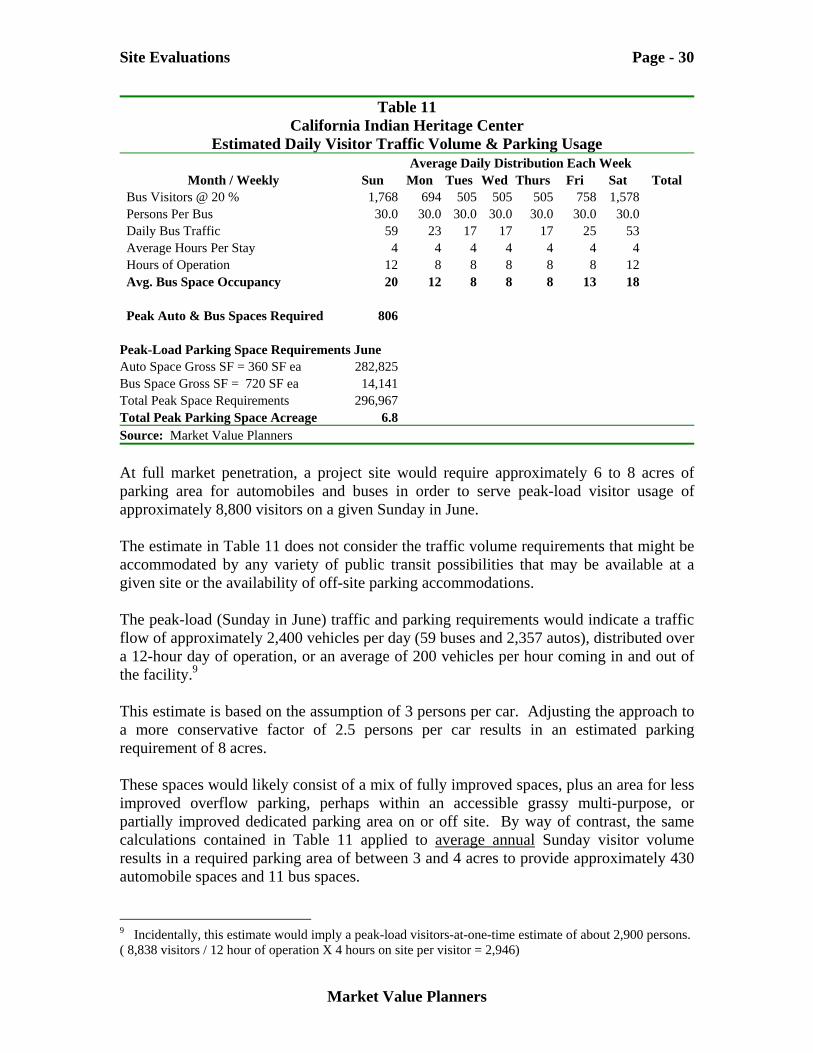
Traffic Flow & Parking Requirements The table below provides a planning measure of the parking requirements and traffic flow impact of the project based on the monthly visitor volume estimates contained in the Market Study Section II (Table 5) presentation, distributed by expected daily visitors throughout the week. The purpose of the presentation is to establish a preliminary measure of the traffic volume impact at the site entrances and internal parking requirements to sustain the estimated visitor volume. While the table is somewhat tedious it is useful in capturing a better picture of the seasonal and weekly flow considerations that will need to be addressed in the forward planning processes.
Table 11 California Indian Heritage Center
Estimated Daily Visitor Traffic Volume & Parking Usage Average Daily Distribution Each Week
Month / Weekly Sun Mon Tues Wed Thurs Fri Sat Total Average Daily Visitor Distribution 28.0% 11.0% 8.0% 8.0% 8.0% 12.0% 25.0% 100.0%
Jan 2,471 971 706 706 706 1,059 2,206 8,824 Feb 3,430 1,348 980 980 980 1,470 3,063 12,251 Mar 4,188 1,645 1,197 1,197 1,197 1,795 3,739 14,958 Apr 5,631 2,212 1,609 1,609 1,609 2,413 5,028 20,110 May 7,435 2,921 2,124 2,124 2,124 3,186 6,638 26,553
Jun Peak Usage 8,838 3,472 2,525 2,525 2,525 3,788 7,891 31,565 Jul 7,851 3,084 2,243 2,243 2,243 3,365 7,010 28,041
Aug 7,150 2,809 2,043 2,043 2,043 3,064 6,384 25,534 Sep 4,045 1,589 1,156 1,156 1,156 1,733 3,611 14,446 Oct 2,636 1,036 753 753 753 1,130 2,354 9,415 Nov 2,105 827 601 601 601 902 1,879 7,518 Dec 2,277 894 650 650 650 976 2,033 8,131
Average Weekly Visitors 4,846 1,904 1,385 1,385 1,385 2,077 4,327 17,308 Times 52 Weeks Annual Visits = 900,000
Peak Load Daily Parking Requirements June Auto Visitors @ 80 % 7,071 2,778 2,020 2,020 2,020 3,030 6,313 Persons Per Auto 3.0 3.0 3.0 3.0 3.0 3.0 3.0 Daily Auto Traffic 2,357 926 673 673 673 1,010 2,104 Average Hours Per Stay 4 4 4 4 4 4 4 Hours of Operation 12 8 8 8 8 8 12 Avg. Auto Space Occupancy 786 463 337 337 337 505 701
Site Evaluations Page - 30
Market Value Planners
Table 11 California Indian Heritage Center
Estimated Daily Visitor Traffic Volume & Parking Usage Average Daily Distribution Each Week
Month / Weekly Sun Mon Tues Wed Thurs Fri Sat Total Bus Visitors @ 20 % 1,768 694 505 505 505 758 1,578 Persons Per Bus 30.0 30.0 30.0 30.0 30.0 30.0 30.0 Daily Bus Traffic 59 23 17 17 17 25 53 Average Hours Per Stay 4 4 4 4 4 4 4 Hours of Operation 12 8 8 8 8 8 12 Avg. Bus Space Occupancy 20 12 8 8 8 13 18 Peak Auto & Bus Spaces Required 806 Peak-Load Parking Space Requirements June Auto Space Gross SF = 360 SF ea 282,825 Bus Space Gross SF = 720 SF ea 14,141 Total Peak Space Requirements 296,967 Total Peak Parking Space Acreage 6.8 Source: Market Value Planners At full market penetration, a project site would require approximately 6 to 8 acres of parking area for automobiles and buses in order to serve peak-load visitor usage of approximately 8,800 visitors on a given Sunday in June. The estimate in Table 11 does not consider the traffic volume requirements that might be accommodated by any variety of public transit possibilities that may be available at a given site or the availability of off-site parking accommodations. The peak-load (Sunday in June) traffic and parking requirements would indicate a traffic flow of approximately 2,400 vehicles per day (59 buses and 2,357 autos), distributed over a 12-hour day of operation, or an average of 200 vehicles per hour coming in and out of the facility.9 This estimate is based on the assumption of 3 persons per car. Adjusting the approach to a more conservative factor of 2.5 persons per car results in an estimated parking requirement of 8 acres. These spaces would likely consist of a mix of fully improved spaces, plus an area for less improved overflow parking, perhaps within an accessible grassy multi-purpose, or partially improved dedicated parking area on or off site. By way of contrast, the same calculations contained in Table 11 applied to average annual Sunday visitor volume results in a required parking area of between 3 and 4 acres to provide approximately 430 automobile spaces and 11 bus spaces. 9 Incidentally, this estimate would imply a peak-load visitors-at-one-time estimate of about 2,900 persons. ( 8,838 visitors / 12 hour of operation X 4 hours on site per visitor = 2,946)
Site Evaluations Page - 31
Market Value Planners
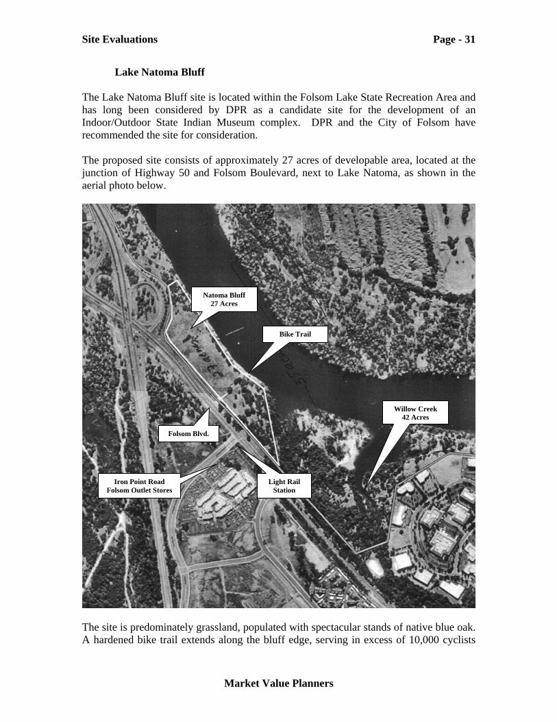
Lake Natoma Bluff The Lake Natoma Bluff site is located within the Folsom Lake State Recreation Area and has long been considered by DPR as a candidate site for the development of an Indoor/Outdoor State Indian Museum complex. DPR and the City of Folsom have recommended the site for consideration. The proposed site consists of approximately 27 acres of developable area, located at the junction of Highway 50 and Folsom Boulevard, next to Lake Natoma, as shown in the aerial photo below.
The site is predominately grassland, populated with spectacular stands of native blue oak. A hardened bike trail extends along the bluff edge, serving in excess of 10,000 cyclists
Natoma Bluff 27 Acres
Folsom Blvd.
Willow Creek 42 Acres
Light Rail Station
Bike Trail
Iron Point Road Folsom Outlet Stores
Site Evaluations Page - 32
Market Value Planners
per week, during its peak season. This bike trail extends some 34 miles from Willow Creek to Discovery Park in Sacramento as part of the American River Parkway trail system. The adjacent Willow Creek area is currently the only access point to the Natoma Bluff site via the bike trail and other walking paths. Limited parking, day use, and boat launch facilities are in place at Willow Creek. The City of Folsom has expressed its support for the location of the CIHC complex at this site.
Opportunities & Strengths Infrastructure - The site provides good access to required infrastructure. A 20” sewer lines run parallel to the site along Folsom Boulevard. Municipal water is represented to also be available along Folsom Boulevard next to the site, including power and communications. Accessibility – Generally good access and egress is available from Highway 50 at the Folsom Blvd., exit to the sight. A light rail transit station is under construction across from Folsom Blvd., adjacent to the Bluff site. This improvement will provide rail access to the site from throughout the Sacramento metropolitan area. No immediate access to the site is currently available. The City of Folsom is willing to apply for federal funding to construct a two-lane turnout and traffic control system for the site at the junction of Folsom Boulevard and Iron Point Road, adjacent to the site. The expected current cost of the project is $750,000. Traffic engineers with the City are confident that the two lane turn out proposed could accommodate up to 300 vehicles per hour, more than the 200 vehicles per hour, peak-load (Sunday-June) estimate requirement described in Table 11, above. The City of Folsom, through the Federal Housing and Urban Development Administration would apply for funding for the traffic turnout. Federal budgeting cycles typically run on a three-year time schedule from application to funding. Soil Conditions – Soil conditions in the area do not appear to pose any significant barriers to development. The site is not in a flood plain area. Land Assemblage Ownership and Control - The 27 acre parcel, shown above is owned by Department of Parks and Recreation (DPR). The Bureau of Reclamation (BOR) is the owner of the strip of land surrounding the parcel extending to Lake Natoma. These lands are administered by DPR under a lease agreement with BOR. The existing lease agreement sunsets in 2006 and discussions are underway between the agencies regarding a new ongoing agreement. The BOR has supported the concept of development of an Indian Museum at the site since its inclusion in the existing General Plan for administration of the SRA. Planning Environment – The lead agency for the project would be DPR in conjunction with BOR. The 1978 State Park General Plan identifies the possible planned use of the
Site Evaluations Page - 33
Market Value Planners
site as a State Indian Museum/Cultural Heritage Center. An update to the General Plan and the BOR Resource Management plan is now under joint development. It is expected that support for a complex, of acceptable scale and proportion, would continue to be embraced by both the DPR and BOR. Because of federal ownership of the lands, both NEPA and CEQA environmental reviews of proposed improvements would be required. Timeline of Availability – The Natoma Bluff site could be available immediately, subject to a more definitive use plan for the proposed project. The timing of the General Plan update, now under way is advantageous.
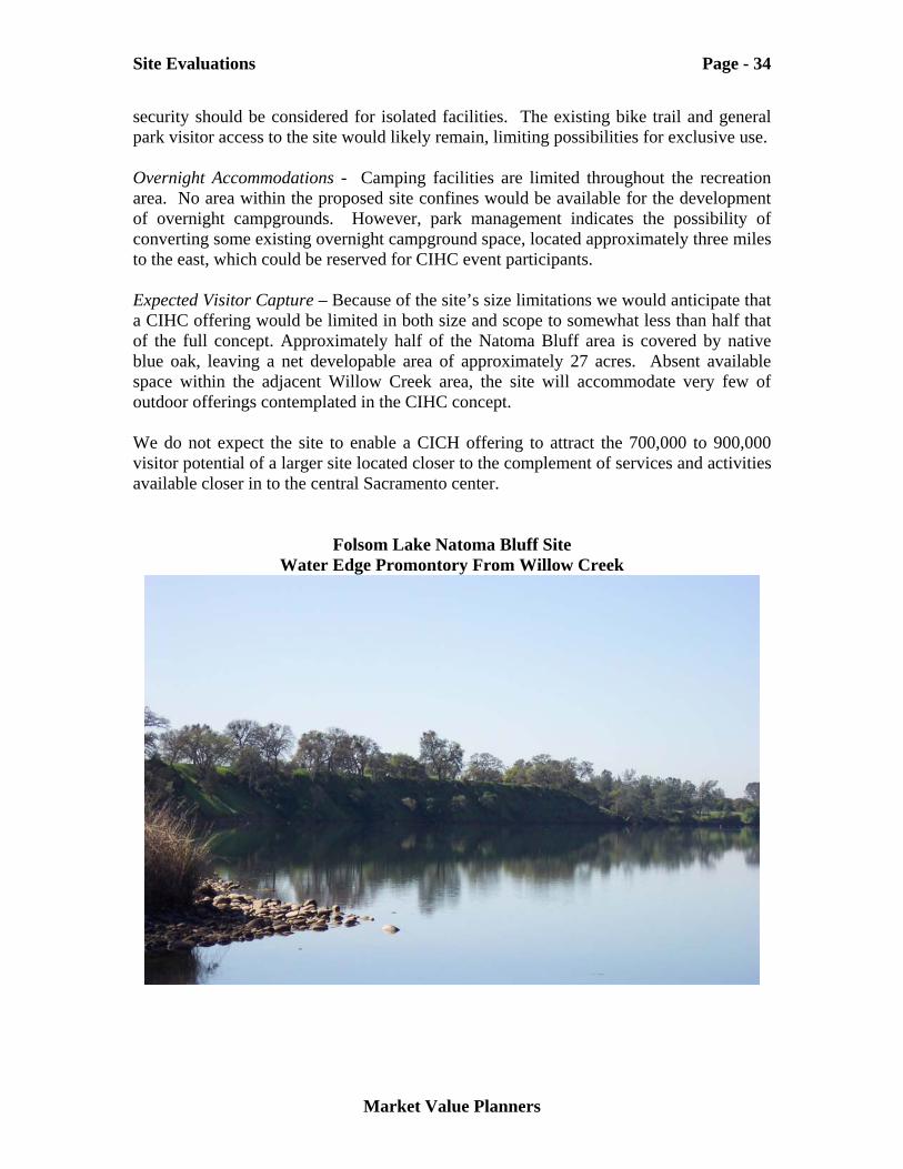
Threats & Weaknesses Site Size - Although the site offers a marvelous view out over Lake Natoma, its size (27 Acres) would significantly constrain the scope of the indoor and outdoor elements of the CIHC concept able to be offered. The orientation of the facilities would likely be away from the Folsom Blvd. corridor and over the lake. However, the existing bike and walking trail will need to remain available compromising the sense of place and exclusive use. Direct access to the water is not possible from Natoma Bluff, which is approximately 40 feet above the waterline. Water access would be possible on a non-exclusive basis via the adjacent Willow Creek day use boat launch and day-use area. Water access from Willow Creek is compromised somewhat by the stone tailings remaining from historic mining operations and will limit interpretation of pre-contact relations with the land. These tailing features are considered to be an element of historic significance in the overall SRA General Plan for the area. These features are shown in the site photo included below taken from the Willow Creek boat launch area, facing Natoma Bluff. The native blue oak grove is also a protected element of the site, which will further constrain its development potential. Parking – The site presents challenges in the development of adequate parking facilities, located close to the main cultural center. Its narrow configuration, protected oak and other plant species may constrain the ability to provide ample and convenient parking. This constraint might be mitigated to some extent by shared weekend use of planned light rail station parking facility under construction across Folsom Boulevard at the corner of Iron Point Drive. Ambiance - Although the site offers a marvelous view over Lake Natoma, the immediate area has been undergoing steady housing and commercial development over the past years. Much of bluff area on the opposite side of the lake from the park has been absorbed in residential development. The site provides some challenge in achieving an experience of being separated from the surrounding urban environment. Visitor Mix – State Park staff caution that along with the significant increase in the suburban development around the Natoma area, they have noticed an increase in the level of petty crime and vandalism incidents taking place. They caution that additional
Site Evaluations Page - 34
Market Value Planners
security should be considered for isolated facilities. The existing bike trail and general park visitor access to the site would likely remain, limiting possibilities for exclusive use. Overnight Accommodations - Camping facilities are limited throughout the recreation area. No area within the proposed site confines would be available for the development of overnight campgrounds. However, park management indicates the possibility of converting some existing overnight campground space, located approximately three miles to the east, which could be reserved for CIHC event participants. Expected Visitor Capture – Because of the site’s size limitations we would anticipate that a CIHC offering would be limited in both size and scope to somewhat less than half that of the full concept. Approximately half of the Natoma Bluff area is covered by native blue oak, leaving a net developable area of approximately 27 acres. Absent available space within the adjacent Willow Creek area, the site will accommodate very few of outdoor offerings contemplated in the CIHC concept. We do not expect the site to enable a CICH offering to attract the 700,000 to 900,000 visitor potential of a larger site located closer to the complement of services and activities available closer in to the central Sacramento center.
Folsom Lake Natoma Bluff Site Water Edge Promontory From Willow Creek
Site Evaluations Page - 35
Market Value Planners
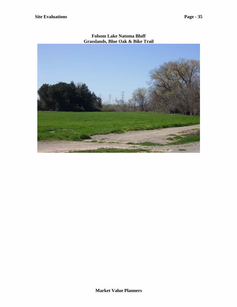
Folsom Lake Natoma Bluff
Grasslands, Blue Oak & Bike Trail
Site Evaluations Page - 36
Market Value Planners
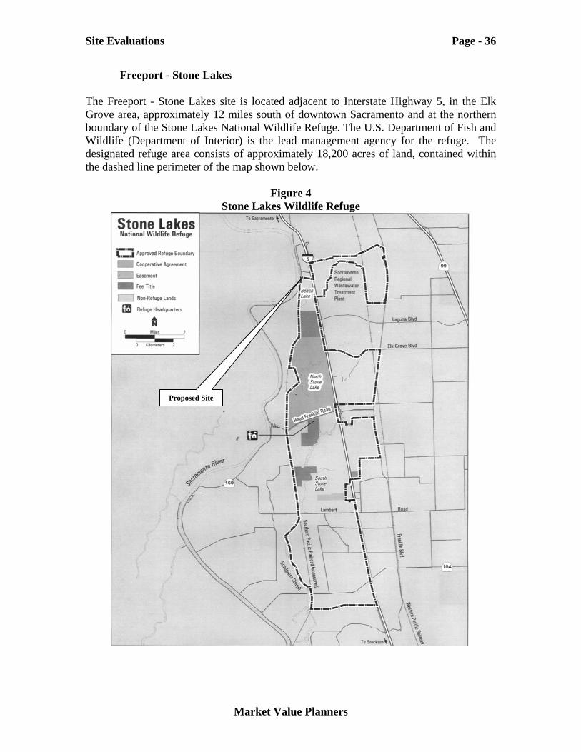
Freeport - Stone Lakes The Freeport - Stone Lakes site is located adjacent to Interstate Highway 5, in the Elk Grove area, approximately 12 miles south of downtown Sacramento and at the northern boundary of the Stone Lakes National Wildlife Refuge. The U.S. Department of Fish and Wildlife (Department of Interior) is the lead management agency for the refuge. The designated refuge area consists of approximately 18,200 acres of land, contained within the dashed line perimeter of the map shown below.
Figure 4 Stone Lakes Wildlife Refuge
Proposed Site
Site Evaluations Page - 37
Market Value Planners
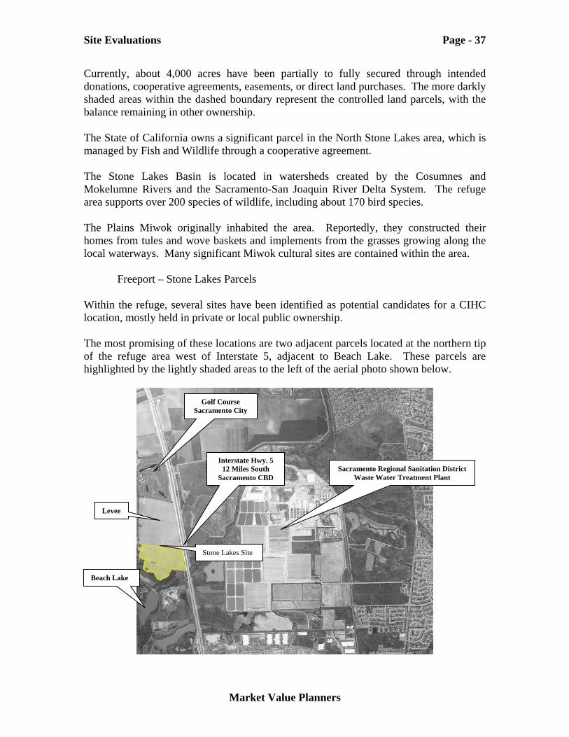
Currently, about 4,000 acres have been partially to fully secured through intended donations, cooperative agreements, easements, or direct land purchases. The more darkly shaded areas within the dashed boundary represent the controlled land parcels, with the balance remaining in other ownership. The State of California owns a significant parcel in the North Stone Lakes area, which is managed by Fish and Wildlife through a cooperative agreement. The Stone Lakes Basin is located in watersheds created by the Cosumnes and Mokelumne Rivers and the Sacramento-San Joaquin River Delta System. The refuge area supports over 200 species of wildlife, including about 170 bird species. The Plains Miwok originally inhabited the area. Reportedly, they constructed their homes from tules and wove baskets and implements from the grasses growing along the local waterways. Many significant Miwok cultural sites are contained within the area.
Freeport – Stone Lakes Parcels Within the refuge, several sites have been identified as potential candidates for a CIHC location, mostly held in private or local public ownership. The most promising of these locations are two adjacent parcels located at the northern tip of the refuge area west of Interstate 5, adjacent to Beach Lake. These parcels are highlighted by the lightly shaded areas to the left of the aerial photo shown below.
Stone Lakes Site
Sacramento Regional Sanitation District Waste Water Treatment Plant
Interstate Hwy. 5 12 Miles South
Sacramento CBD
Golf Course Sacramento City
Levee
Beach Lake
Site Evaluations Page - 38
Market Value Planners
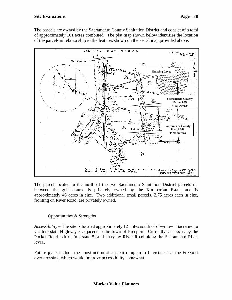
The parcels are owned by the Sacramento County Sanitation District and consist of a total of approximately 161 acres combined. The plat map shown below identifies the location of the parcels in relationship to the features shown on the aerial map provided above.
The parcel located to the north of the two Sacramento Sanitation District parcels in-between the golf course is privately owned by the Komoorian Estate and is approximately 46 acres in size. Two additional small parcels, 2.75 acres each in size, fronting on River Road, are privately owned.
Opportunities & Strengths Accessibility – The site is located approximately 12 miles south of downtown Sacramento via Interstate Highway 5 adjacent to the town of Freeport. Currently, access is by the Pocket Road exit of Interstate 5, and entry by River Road along the Sacramento River levee. Future plans include the construction of an exit ramp from Interstate 5 at the Freeport over crossing, which would improve accessibility somewhat.
Sacramento County Parcel 048
99.98 Acreas
Sacramento County Parcel 049
61.50 Acreas
Existing Levee
Golf Course
Site Evaluations Page - 39
Market Value Planners
Flood & Soil Conditions – The sites are within the 100-year flood plain and have been partially inundated as recently as 1997. These lands are within the jurisdiction of the Sacramento Area Flood Control Agency (SAFCA). A levee currently bounds the northern portion of the property. SAFCA has considered a reconfiguration of the levee so as to protect some of the area from flood hazard. Site Size - The combined size of the two parcels is approximately 160 acres. This would be sufficient to accommodate both the Heritage Center central indoor facilities and provide access to well buffered outdoor areas both within wetland environs and outside to the north of the SAFCA renovated levee. Part of a project development plan for the site might include wetlands restoration approaches providing direct water access that would be well aligned with the needs of CIHC concept and the overall Stone Lakes Wildlife Refuge mission. Partnership Potentials – The refuge management goals and objectives of the Fish and Wildlife Department are quite well aligned with those of the CIHC. In addition to their land acquisition tasks, they are also charged with a significant interpretative and wetland restoration function. Many opportunities would be available for the CIHC and the Stone Lakes Wildlife Refuge to collaborate in their program development and interpretive functions. Adjacent Land Uses – All adjacent land parcels to the south are located within the designated refuge area. Success of the refuge assemblage efforts will result in a cumulative benefit the CIHC. A municipal public golf course is located directly to the north of the property. This recreational use offers some variety in available immediate area activities for CIHC visitors.
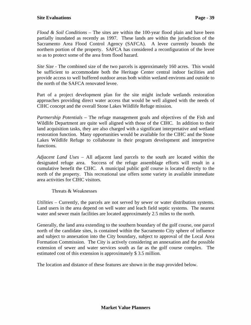
Threats & Weaknesses Utilities – Currently, the parcels are not served by sewer or water distribution systems. Land users in the area depend on well water and leach field septic systems. The nearest water and sewer main facilities are located approximately 2.5 miles to the north. Generally, the land area extending to the southern boundary of the golf course, one parcel north of the candidate sites, is contained within the Sacramento City sphere of influence and subject to annexation into the City boundary, subject to approval of the Local Area Formation Commission. The City is actively considering an annexation and the possible extension of sewer and water services south as far as the golf course complex. The estimated cost of this extension is approximately $ 3.5 million. The location and distance of these features are shown in the map provided below.
Site Evaluations Page - 40
Market Value Planners
Land Ownership – The Sacramento County Regional Sanitation District currently owns the nominated parcels. No commitment has yet been made for the sale of the parcels. Should the Sanitation District be amenable to a disposition of the parcels it may be possible for them to be purchased by Fish and Wildlife and then deeded to the State in exchange for properties of “equivalent value” held by the State, possibly within the refuge. No Federal funding has been appropriated for this purpose. Planning Environment – The planning jurisdiction for the parcel is the County of Sacramento and the parcels are currently zoned for agricultural use. Any transaction would be subject to appropriate entitlements. Land Condition – Currently the parcels are leased to a farming operation. They would require substantial restoration over an unknown period of time to restore them to their pre contact condition. The parcels do not provide direct river access. The Sacramento River flows adjacent to the parcels, across River Road, the rail line and levee to the east.
Freeport – Stone Lakes Project Site
Required Sewer & Water Extension Approx. 2.5 Miles
Sacramento City Sphere of Influence
Site Evaluations Page - 41
Market Value Planners
While proximity to Interstate Highway 5 is a positive accessibility feature, noise from the highway could impact the visitor experience. Expected Visitor Capture – While the Freeport - Stone Lakes site is located within reasonably close proximity to downtown Sacramento and the intersection of Intestate Highways 5, 80, and Highway 50, somewhat less penetration of the full visitor potential may result. The marginal visitor, planning two or three activities during their stay that are located close in to the downtown area may opt for an alternative rather than confront the time and financial cost of trip to the fringe of the city. We would characterize the location features of this site as a potential threat as opposed to a decided weakness. Of the approximately 15.4 million visitors to Sacramento reported in 2002, approximately 9 million were in the City of Sacramento or about 60 percent.10
American River Parkway Three sites were originally proposed within the Lower American River (LAR) corridor. (Bushy Lake / Cal Expo, Sutter’s Landing Park and Northgate) Generally the LAR corridor extends from Folsom Dam, approximately 35 miles to the east of downtown Sacramento along the American River to its confluence with the Sacramento River. The Sacramento Area Flood Control Agency (SAFCA) in collaboration with other regional and state agencies maintains a LAR Corridor Management Plan. At the time of the original site nominations, the LAR Corridor Plan was in the process of being updated and these nominations were considered to offer an opportunity for inclusion of concepts such as the development of a CIHC offering within its boundaries, if appropriately scoped. Lands located below the levee along the LAR corridor are administered by SAFCA. Two of the nominated sites are located below the levee structure within SAFCA’s jurisdiction (Bushy Lake and Northgate) while the Sutter’s Landing Park site is located on the south side of the American River, at or above the levee. 10 Sacramento Convention and Visitor Bureau, Dean Runyan Associates
Site Evaluations Page - 42
Market Value Planners
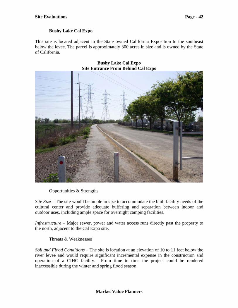
Bushy Lake Cal Expo This site is located adjacent to the State owned California Exposition to the southeast below the levee. The parcel is approximately 300 acres in size and is owned by the State of California.
Bushy Lake Cal Expo Site Entrance From Behind Cal Expo
Opportunities & Strengths Site Size – The site would be ample in size to accommodate the built facility needs of the cultural center and provide adequate buffering and separation between indoor and outdoor uses, including ample space for overnight camping facilities. Infrastructure – Major sewer, power and water access runs directly past the property to the north, adjacent to the Cal Expo site.
Threats & Weaknesses Soil and Flood Conditions – The site is location at an elevation of 10 to 11 feet below the river levee and would require significant incremental expense in the construction and operation of a CIHC facility. From time to time the project could be rendered inaccessible during the winter and spring flood season.
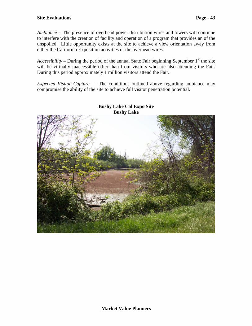
Site Evaluations Page - 43
Market Value Planners
Ambiance - The presence of overhead power distribution wires and towers will continue to interfere with the creation of facility and operation of a program that provides an of the unspoiled. Little opportunity exists at the site to achieve a view orientation away from either the California Exposition activities or the overhead wires. Accessibility – During the period of the annual State Fair beginning September 1st the site will be virtually inaccessible other than from visitors who are also attending the Fair. During this period approximately 1 million visitors attend the Fair. Expected Visitor Capture – The conditions outlined above regarding ambiance may compromise the ability of the site to achieve full visitor penetration potential.
Bushy Lake Cal Expo Site Bushy Lake
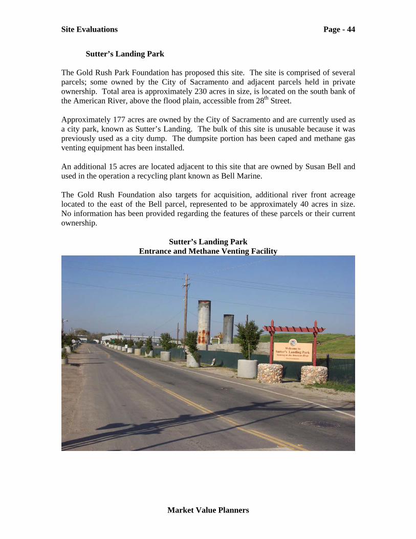
Site Evaluations Page - 44
Market Value Planners
Sutter’s Landing Park The Gold Rush Park Foundation has proposed this site. The site is comprised of several parcels; some owned by the City of Sacramento and adjacent parcels held in private ownership. Total area is approximately 230 acres in size, is located on the south bank of the American River, above the flood plain, accessible from 28th Street. Approximately 177 acres are owned by the City of Sacramento and are currently used as a city park, known as Sutter’s Landing. The bulk of this site is unusable because it was previously used as a city dump. The dumpsite portion has been caped and methane gas venting equipment has been installed. An additional 15 acres are located adjacent to this site that are owned by Susan Bell and used in the operation a recycling plant known as Bell Marine. The Gold Rush Foundation also targets for acquisition, additional river front acreage located to the east of the Bell parcel, represented to be approximately 40 acres in size. No information has been provided regarding the features of these parcels or their current ownership.
Sutter’s Landing Park Entrance and Methane Venting Facility
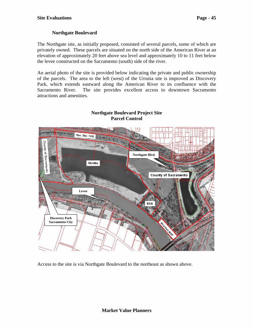
Site Evaluations Page - 45
Market Value Planners
Northgate Boulevard The Northgate site, as initially proposed, consisted of several parcels, some of which are privately owned. These parcels are situated on the north side of the American River at an elevation of approximately 20 feet above sea level and approximately 10 to 11 feet below the levee constructed on the Sacramento (south) side of the river. An aerial photo of the site is provided below indicating the private and public ownership of the parcels. The area to the left (west) of the Urrutia site is improved as Discovery Park, which extends eastward along the American River to its confluence with the Sacramento River. The site provides excellent access to downtown Sacramento attractions and amenities.
Northgate Boulevard Project Site Parcel Control
Access to the site is via Northgate Boulevard to the northeast as shown above.
Northgate Blvd.
Levee
Discovery Park Sacramento City
Site Evaluations Page - 46
Market Value Planners
Parcel ownership and sizes are summarized in the table provided below.
Table 12 Northgate Boulevard Site Ownership
Parcel Owners Acreage
Henry Urrutia 76.3 Camp Pollock Boy Scouts of America 15.2 Riverdale Mobile Home Park 6.6 Sub Total 98.1 Sacramento County 103.1 Total 201.2 Source: Sacramento County Records
SAFCA expressed an interest in working with the Task Force and the State Department of Parks and Recreation in connection with the acquisition of the privately controlled sites for the purpose of developing the CIHC project. The approach suggested was for the privately controlled parcels to be acquired by SAFCA using State sources of funding available through Proposition 250, designated for flood area improvements, and then deed the properties in fee to DPR, subject to project design approval. Proposition 250 funding was to remain available through the 2006 fiscal year. The Riverdale mobile home park parcel owner expressed an interest in divesting its property and relocating the existing lessees. The Urrutia parcel owner had not indicated a strong interest in a sale but has not rejected the concept out of hand. The Urrutia parcel has been used for several years as a gravel-mining site and would require significant restoration efforts, if included in a land assemblage program for the project. The Camp Pollock owners have not expressed a strong interest in a divesture having been long time users of the property in connection with their Scouting and area youth programs. However, contacts with the owners indicate a favorable disposition to the project and a willingness to work cooperatively and positively toward a mutually agreeable use of the surrounding properties in the interest of their constituency and the surrounding community.
Opportunities & Strengths Site Size – The site would be ample in size to accommodate the built facility needs of the CIHC concept and provide adequate buffering and separation between indoor and outdoor uses, including space for overnight camping facilities. Some terracing of the steep riverbank could provide good access to the water. While acquisition of the Urrutia
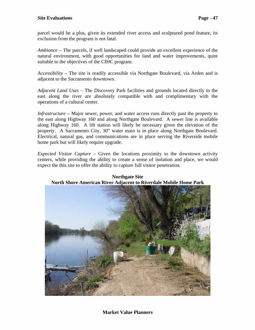
Site Evaluations Page - 47
Market Value Planners
parcel would be a plus, given its extended river access and sculptured pond feature, its exclusion from the program is not fatal. Ambiance – The parcels, if well landscaped could provide an excellent experience of the natural environment, with good opportunities for land and water improvements, quite suitable to the objectives of the CIHC program. Accessibility – The site is readily accessible via Northgate Boulevard, via Arden and is adjacent to the Sacramento downtown. Adjacent Land Uses – The Discovery Park facilities and grounds located directly to the east along the river are absolutely compatible with and complimentary with the operations of a cultural center. Infrastructure – Major sewer, power, and water access runs directly past the property to the east along Highway 160 and along Northgate Boulevard. A sewer line is available along Highway 160. A lift station will likely be necessary given the elevation of the property. A Sacramento City, 30” water main is in place along Northgate Boulevard. Electrical, natural gas, and communications are in place serving the Riverside mobile home park but will likely require upgrade. Expected Visitor Capture – Given the locations proximity to the downtown activity centers, while providing the ability to create a sense of isolation and place, we would expect the this site to offer the ability to capture full visitor penetration.
Northgate Site North Shore American River Adjacent to Riverdale Mobile Home Park
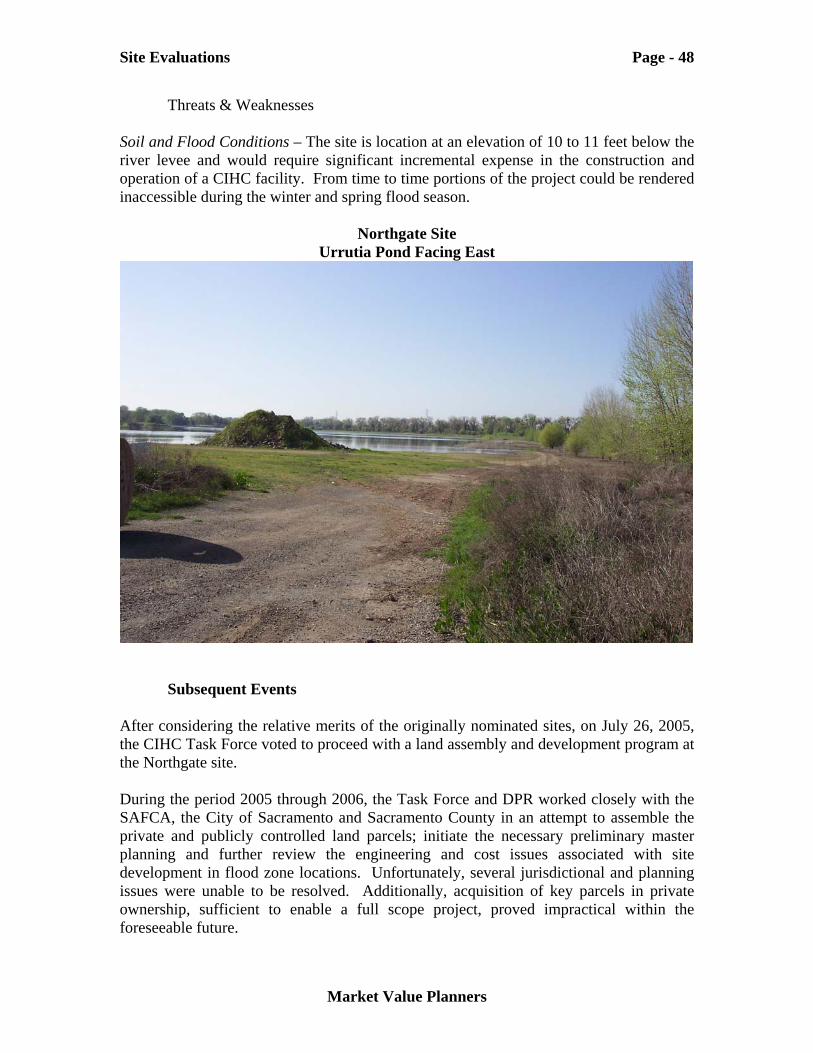
Site Evaluations Page - 48
Market Value Planners
Threats & Weaknesses Soil and Flood Conditions – The site is location at an elevation of 10 to 11 feet below the river levee and would require significant incremental expense in the construction and operation of a CIHC facility. From time to time portions of the project could be rendered inaccessible during the winter and spring flood season.
Northgate Site Urrutia Pond Facing East
Subsequent Events
After considering the relative merits of the originally nominated sites, on July 26, 2005, the CIHC Task Force voted to proceed with a land assembly and development program at the Northgate site. During the period 2005 through 2006, the Task Force and DPR worked closely with the SAFCA, the City of Sacramento and Sacramento County in an attempt to assemble the private and publicly controlled land parcels; initiate the necessary preliminary master planning and further review the engineering and cost issues associated with site development in flood zone locations. Unfortunately, several jurisdictional and planning issues were unable to be resolved. Additionally, acquisition of key parcels in private ownership, sufficient to enable a full scope project, proved impractical within the foreseeable future.
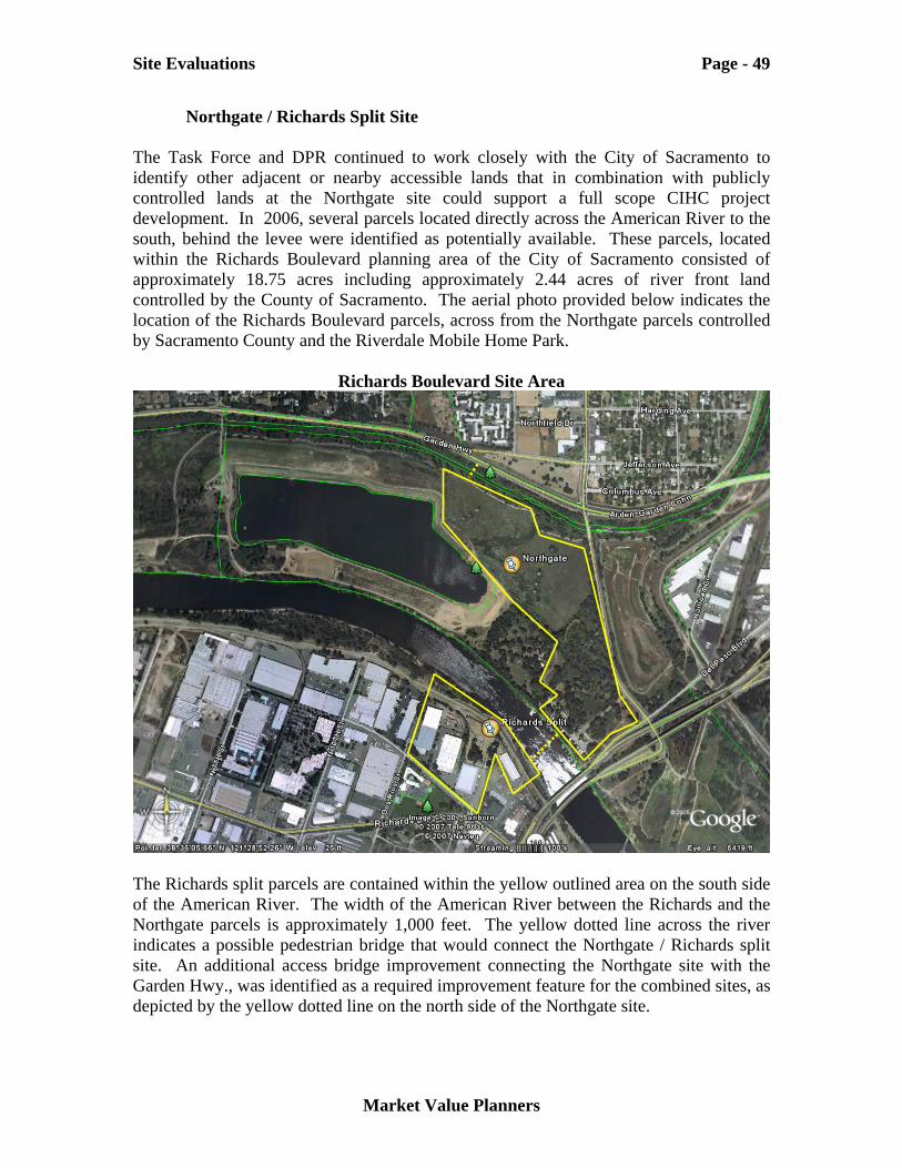
Site Evaluations Page - 49
Market Value Planners
Northgate / Richards Split Site The Task Force and DPR continued to work closely with the City of Sacramento to identify other adjacent or nearby accessible lands that in combination with publicly controlled lands at the Northgate site could support a full scope CIHC project development. In 2006, several parcels located directly across the American River to the south, behind the levee were identified as potentially available. These parcels, located within the Richards Boulevard planning area of the City of Sacramento consisted of approximately 18.75 acres including approximately 2.44 acres of river front land controlled by the County of Sacramento. The aerial photo provided below indicates the location of the Richards Boulevard parcels, across from the Northgate parcels controlled by Sacramento County and the Riverdale Mobile Home Park.
Richards Boulevard Site Area
The Richards split parcels are contained within the yellow outlined area on the south side of the American River. The width of the American River between the Richards and the Northgate parcels is approximately 1,000 feet. The yellow dotted line across the river indicates a possible pedestrian bridge that would connect the Northgate / Richards split site. An additional access bridge improvement connecting the Northgate site with the Garden Hwy., was identified as a required improvement feature for the combined sites, as depicted by the yellow dotted line on the north side of the Northgate site.
Site Evaluations Page - 50
Market Value Planners
The table below summarizes the ownership distribution of acreage that was expected to be available for acquisition in the Richards Boulevard planning area.
Table 13 Richards Boulevard Site Ownership
Parcel Owners Acreage
Private Ownership (various contiguous parcels) 16.31 Sacramento County (one riverfront parcel) 2.44 Total 18.75 Source: California, DPR
The privately controlled Richards parcels are located behind the levee in a predominately, light industry based land use area. While flood protection is a key feature of the site, access and view to the river is very limited. The Sacramento County controlled parcel is located on the wet side of the levee. In the course of more fully evaluating the Northgate site, preliminary master plan scenarios were developed and analyzed. The Task Force embraced an overall facilities design scenario encompassing approximately 125,000 square feet of enclosed facilities as an alternative of the originally anticipated 60,000 square foot planning requirement. The Northgate / Richards split site was expected to accommodate this project requirement by allocating the bulk of the permanent parking and built facilities to the Richards site parcels located behind the levee, with the remainder constructed on the Northgate site to support the seasonal operations and outdoor features. Analyses completed by consulting engineers estimated that the bulk of the Northgate would, on average, be partially submerged for about 1 month each year, during the spring flood season. Given the complexity of splitting the project between the Northgate and Richards sites, the anticipated cost of assembling the land, raising existing structures and construction of the required pedestrian bridge connecting the sites estimates as well as the Northgate –Garden Hwy., access bridge were prepared by the DPR staff and its engineering and planning consultants. The table provided below summarizes the consultant’s estimated cost of land assembly and preparation for the project at the Northgate / Richards split site.
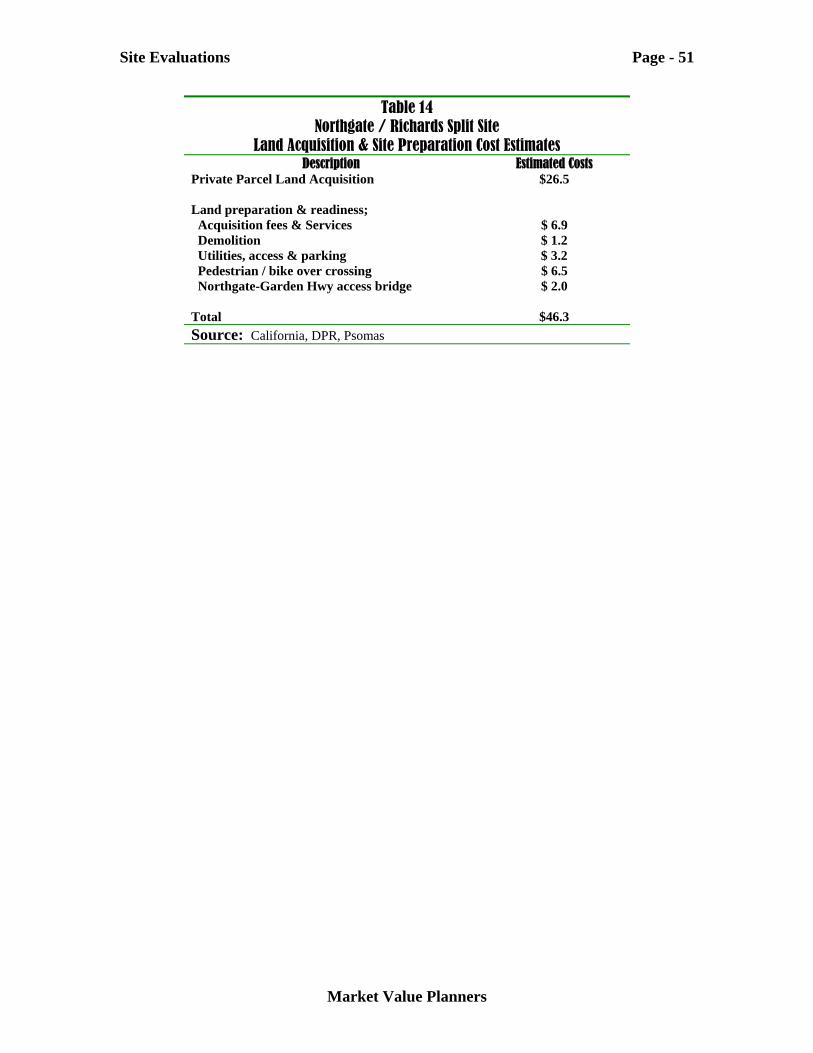
Site Evaluations Page - 51
Market Value Planners
Table 14 Northgate / Richards Split Site
Land Acquisition & Site Preparation Cost Estimates Description Estimated Costs
Private Parcel Land Acquisition $26.5 Land preparation & readiness; Acquisition fees & Services $ 6.9 Demolition $ 1.2 Utilities, access & parking $ 3.2 Pedestrian / bike over crossing $ 6.5 Northgate-Garden Hwy access bridge $ 2.0 Total $46.3 Source: California, DPR, Psomas
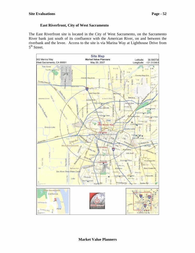
Site Evaluations Page - 52
Market Value Planners
East Riverfront, City of West Sacramento The East Riverfront site is located in the City of West Sacramento, on the Sacramento River bank just south of its confluence with the American River, on and between the riverbank and the levee. Access to the site is via Marina Way at Lighthouse Drive from 5th Street.
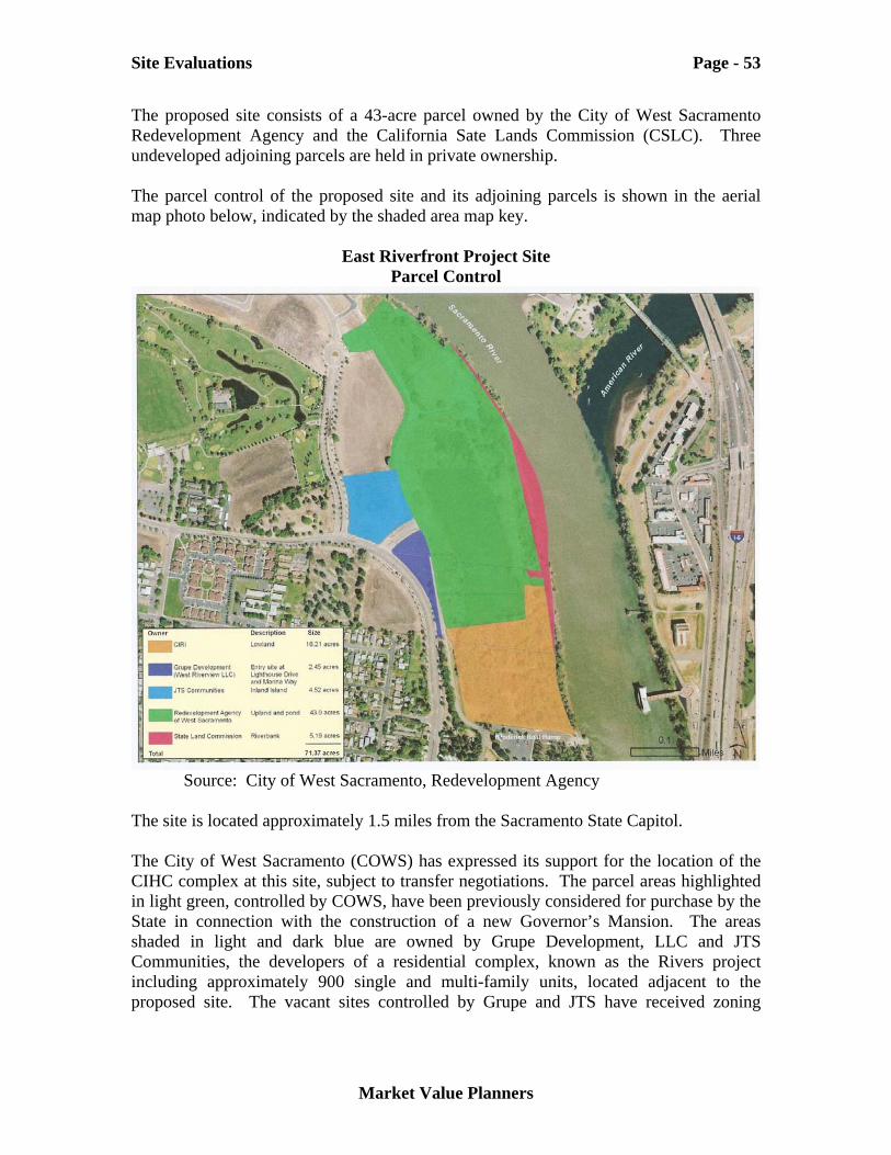
Site Evaluations Page - 53
Market Value Planners
The proposed site consists of a 43-acre parcel owned by the City of West Sacramento Redevelopment Agency and the California Sate Lands Commission (CSLC). Three undeveloped adjoining parcels are held in private ownership. The parcel control of the proposed site and its adjoining parcels is shown in the aerial map photo below, indicated by the shaded area map key.
East Riverfront Project Site Parcel Control
Source: City of West Sacramento, Redevelopment Agency The site is located approximately 1.5 miles from the Sacramento State Capitol. The City of West Sacramento (COWS) has expressed its support for the location of the CIHC complex at this site, subject to transfer negotiations. The parcel areas highlighted in light green, controlled by COWS, have been previously considered for purchase by the State in connection with the construction of a new Governor’s Mansion. The areas shaded in light and dark blue are owned by Grupe Development, LLC and JTS Communities, the developers of a residential complex, known as the Rivers project including approximately 900 single and multi-family units, located adjacent to the proposed site. The vacant sites controlled by Grupe and JTS have received zoning
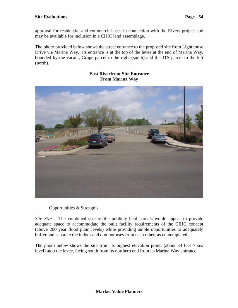
Site Evaluations Page - 54
Market Value Planners
approval for residential and commercial uses in connection with the Rivers project and may be available for inclusion in a CIHC land assemblage. The photo provided below shows the street entrance to the proposed site from Lighthouse Drive via Marina Way. Its entrance is at the top of the levee at the end of Marina Way, bounded by the vacant, Grupe parcel to the right (south) and the JTS parcel to the left (north).
East Riverfront Site Entrance From Marina Way
Opportunities & Strengths Site Size – The combined size of the publicly held parcels would appear to provide adequate space to accommodate the built facility requirements of the CIHC concept (above 200 year flood plain levels) while providing ample opportunities to adequately buffer and separate the indoor and outdoor uses from each other, as contemplated. The photo below shows the site from its highest elevation point, (about 34 feet > sea level) atop the levee, facing south from its northern end from its Marina Way entrance.
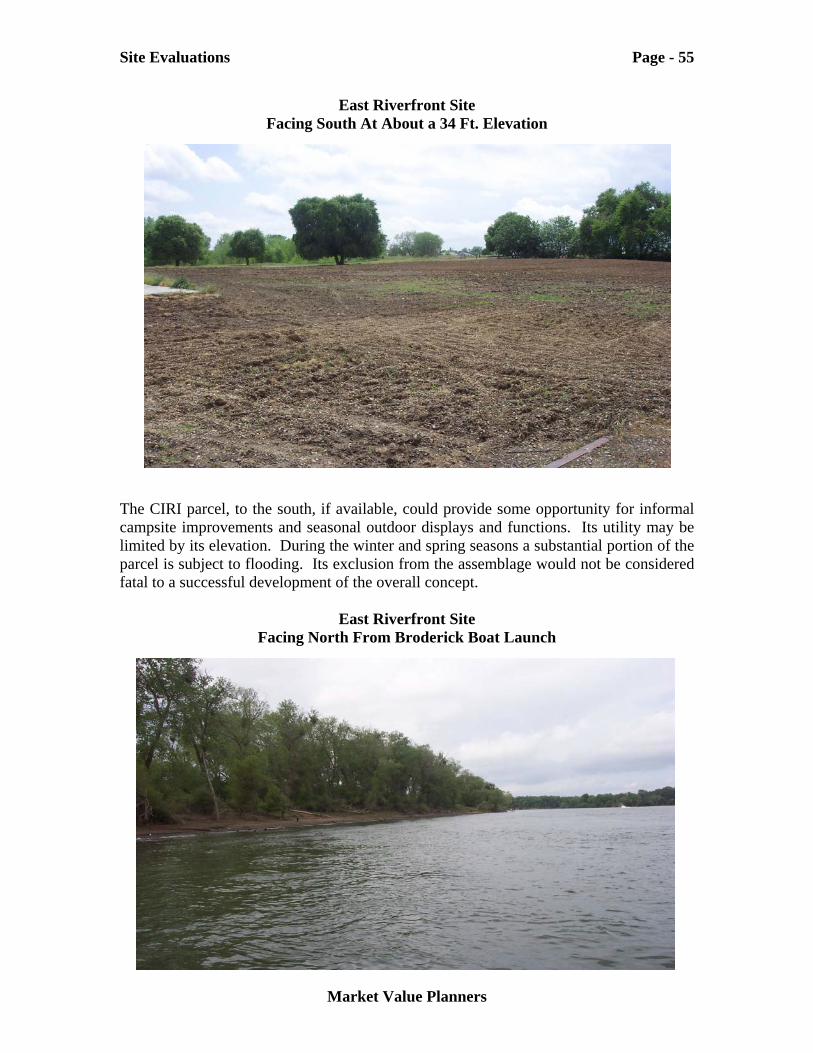
Site Evaluations Page - 55
Market Value Planners
East Riverfront Site Facing South At About a 34 Ft. Elevation
The CIRI parcel, to the south, if available, could provide some opportunity for informal campsite improvements and seasonal outdoor displays and functions. Its utility may be limited by its elevation. During the winter and spring seasons a substantial portion of the parcel is subject to flooding. Its exclusion from the assemblage would not be considered fatal to a successful development of the overall concept.
East Riverfront Site Facing North From Broderick Boat Launch
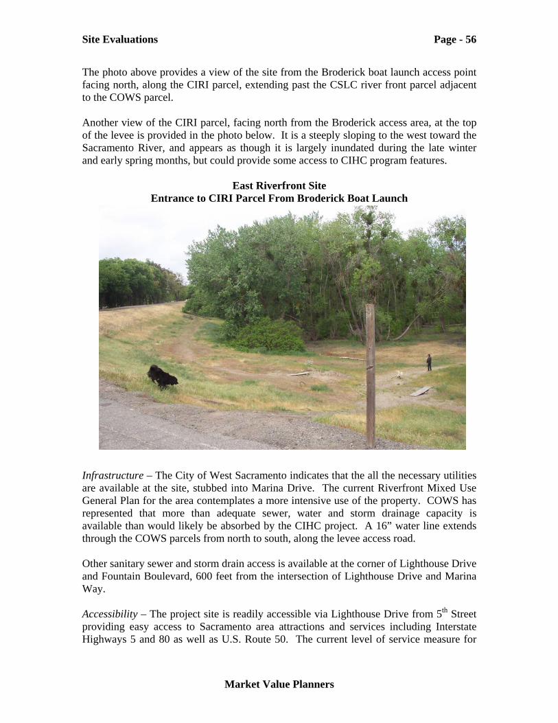
Site Evaluations Page - 56
Market Value Planners
The photo above provides a view of the site from the Broderick boat launch access point facing north, along the CIRI parcel, extending past the CSLC river front parcel adjacent to the COWS parcel. Another view of the CIRI parcel, facing north from the Broderick access area, at the top of the levee is provided in the photo below. It is a steeply sloping to the west toward the Sacramento River, and appears as though it is largely inundated during the late winter and early spring months, but could provide some access to CIHC program features.
East Riverfront Site Entrance to CIRI Parcel From Broderick Boat Launch
Infrastructure – The City of West Sacramento indicates that the all the necessary utilities are available at the site, stubbed into Marina Drive. The current Riverfront Mixed Use General Plan for the area contemplates a more intensive use of the property. COWS has represented that more than adequate sewer, water and storm drainage capacity is available than would likely be absorbed by the CIHC project. A 16” water line extends through the COWS parcels from north to south, along the levee access road. Other sanitary sewer and storm drain access is available at the corner of Lighthouse Drive and Fountain Boulevard, 600 feet from the intersection of Lighthouse Drive and Marina Way. Accessibility – The project site is readily accessible via Lighthouse Drive from 5th Street providing easy access to Sacramento area attractions and services including Interstate Highways 5 and 80 as well as U.S. Route 50. The current level of service measure for
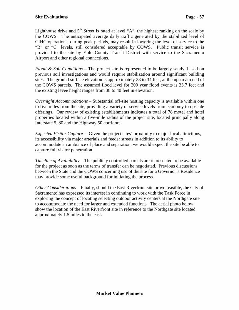
Site Evaluations Page - 57
Market Value Planners
Lighthouse drive and 5th Street is rated at level “A”, the highest ranking on the scale by the COWS. The anticipated average daily traffic generated by the stabilized level of CIHC operations, during peak periods, may result in lowering the level of service to the “B” or “C” levels, still considered acceptable by COWS. Public transit service is provided to the site by Yolo County Transit District with service to the Sacramento Airport and other regional connections. Flood & Soil Conditions – The project site is represented to be largely sandy, based on previous soil investigations and would require stabilization around significant building sites. The ground surface elevation is approximately 28 to 34 feet, at the upstream end of the COWS parcels. The assumed flood level for 200 year flood events is 33.7 feet and the existing levee height ranges from 38 to 40 feet in elevation. Overnight Accommodations – Substantial off-site hosting capacity is available within one to five miles from the site, providing a variety of service levels from economy to upscale offerings. Our review of existing establishments indicates a total of 78 motel and hotel properties located within a five-mile radius of the project site, located principally along Interstate 5, 80 and the Highway 50 corridors. Expected Visitor Capture – Given the project sites’ proximity to major local attractions, its accessibility via major arterials and feeder streets in addition to its ability to accommodate an ambiance of place and separation, we would expect the site be able to capture full visitor penetration. Timeline of Availability – The publicly controlled parcels are represented to be available for the project as soon as the terms of transfer can be negotiated. Previous discussions between the State and the COWS concerning use of the site for a Governor’s Residence may provide some useful background for initiating the process. Other Considerations – Finally, should the East Riverfront site prove feasible, the City of Sacramento has expressed its interest in continuing to work with the Task Force in exploring the concept of locating selecting outdoor activity centers at the Northgate site to accommodate the need for larger and extended functions. The aerial photo below show the location of the East Riverfront site in reference to the Northgate site located approximately 1.5 miles to the east.
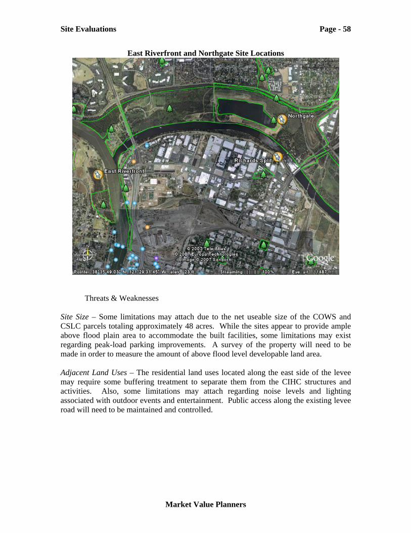
Site Evaluations Page - 58
Market Value Planners
East Riverfront and Northgate Site Locations
Threats & Weaknesses Site Size – Some limitations may attach due to the net useable size of the COWS and CSLC parcels totaling approximately 48 acres. While the sites appear to provide ample above flood plain area to accommodate the built facilities, some limitations may exist regarding peak-load parking improvements. A survey of the property will need to be made in order to measure the amount of above flood level developable land area. Adjacent Land Uses – The residential land uses located along the east side of the levee may require some buffering treatment to separate them from the CIHC structures and activities. Also, some limitations may attach regarding noise levels and lighting associated with outdoor events and entertainment. Public access along the existing levee road will need to be maintained and controlled.
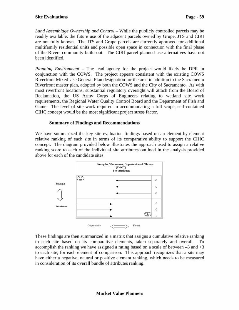
Site Evaluations Page - 59
Market Value Planners
Land Assemblage Ownership and Control – While the publicly controlled parcels may be readily available, the future use of the adjacent parcels owned by Grupe, JTS and CIRI are not fully known. The JTS and Grupe parcels are currently approved for additional multifamily residential units and possible open space in connection with the final phase of the Rivers community build out. The CIRI parcel planned use alternatives have not been identified. Planning Environment – The lead agency for the project would likely be DPR in conjunction with the COWS. The project appears consistent with the existing COWS Riverfront Mixed Use General Plan designation for the area in addition to the Sacramento Riverfront master plan, adopted by both the COWS and the City of Sacramento. As with most riverfront locations, substantial regulatory oversight will attach from the Board of Reclamation, the US Army Corps of Engineers relating to wetland site work requirements, the Regional Water Quality Control Board and the Department of Fish and Game. The level of site work required in accommodating a full scope, self-contained CIHC concept would be the most significant project stress factor.
Summary of Findings and Recommendations We have summarized the key site evaluation findings based on an element-by-element relative ranking of each site in terms of its comparative ability to support the CIHC concept. The diagram provided below illustrates the approach used to assign a relative ranking score to each of the individual site attributes outlined in the analysis provided above for each of the candidate sites. These findings are then summarized in a matrix that assigns a cumulative relative ranking to each site based on its comparative elements, taken separately and overall. To accomplish the ranking we have assigned a rating based on a scale of between –3 and +3 to each site, for each element of comparison. This approach recognizes that a site may have either a negative, neutral or positive element ranking, which needs to be measured in consideration of its overall bundle of attributes ranking.
Strength Weakness
Opportunity Threat
Strengths, Weaknesses, Opportunities & Threats (SWOT)
Site Attributes
+3
+2
+1
-1
-2
-3
Site Evaluations Page - 60
Market Value Planners
Table 13, Summary of Site Strengths & Weaknesses, lists the several elements of comparison described at the beginning of this Site Evaluation Section. Each of the site elements has been evaluated in terms of their apparent opportunities and strengths as well as observed and documented threats and weaknesses. The table provided below has been revised and updated from the one presented in our September 2004 report, based on subsequent events related to the ability to assemble the land parcels evaluated at the Northgate site and the inclusion of the newly nominated East Riverfront site.
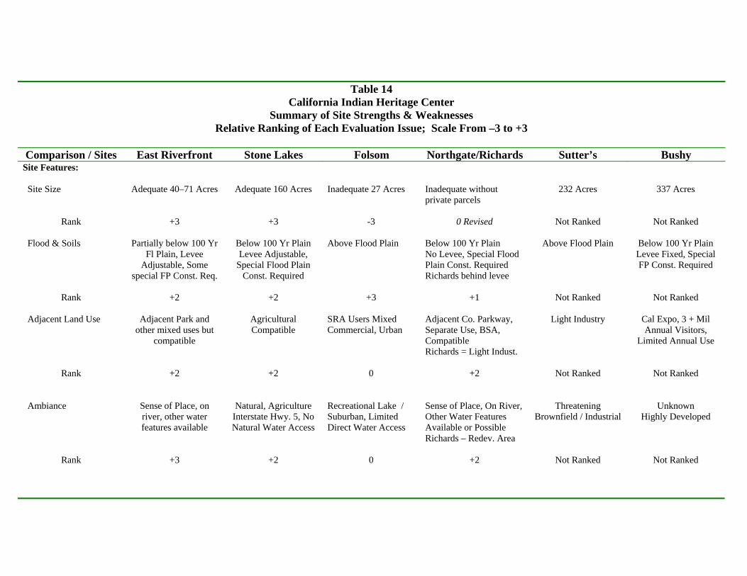
Table 14
California Indian Heritage Center Summary of Site Strengths & Weaknesses
Relative Ranking of Each Evaluation Issue; Scale From –3 to +3
Comparison / Sites East Riverfront Stone Lakes Folsom Northgate/Richards Sutter’s Bushy Site Features: Site Size
Rank Flood & Soils
Rank Adjacent Land Use
Rank Ambiance
Rank
Adequate 40–71 Acres
+3
Partially below 100 Yr Fl Plain, Levee
Adjustable, Some special FP Const. Req.
+2
Adjacent Park and
other mixed uses but compatible
+2
Sense of Place, on river, other water features available
+3
Adequate 160 Acres
+3
Below 100 Yr Plain Levee Adjustable,
Special Flood Plain Const. Required
+2
Agricultural Compatible
+2
Natural, Agriculture Interstate Hwy. 5, No Natural Water Access
+2
Inadequate 27 Acres
-3 Above Flood Plain
+3 SRA Users Mixed Commercial, Urban
0 Recreational Lake / Suburban, Limited Direct Water Access
0
Inadequate without private parcels
0 Revised Below 100 Yr Plain No Levee, Special Flood Plain Const. Required Richards behind levee
+1 Adjacent Co. Parkway, Separate Use, BSA, Compatible Richards = Light Indust.
+2 Sense of Place, On River, Other Water Features Available or Possible Richards – Redev. Area
+2
232 Acres
Not Ranked
Above Flood Plain
Not Ranked
Light Industry
Not Ranked
Threatening Brownfield / Industrial
Not Ranked
337 Acres
Not Ranked
Below 100 Yr Plain Levee Fixed, Special FP Const. Required
Not Ranked
Cal Expo, 3 + Mil Annual Visitors,
Limited Annual Use
Not Ranked
Unknown Highly Developed
Not Ranked
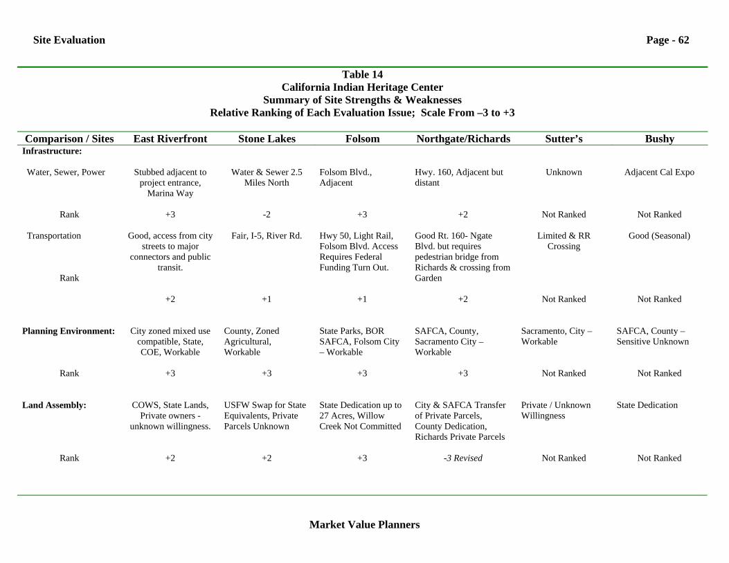
Site Evaluation Page - 62
Market Value Planners
Table 14 California Indian Heritage Center
Summary of Site Strengths & Weaknesses Relative Ranking of Each Evaluation Issue; Scale From –3 to +3
Comparison / Sites East Riverfront Stone Lakes Folsom Northgate/Richards Sutter’s Bushy
Infrastructure: Water, Sewer, Power
Rank Transportation
Rank
Stubbed adjacent to project entrance,
Marina Way
+3
Good, access from city streets to major
connectors and public transit.
+2
Water & Sewer 2.5 Miles North
-2
Fair, I-5, River Rd.
+1
Folsom Blvd., Adjacent
+3
Hwy 50, Light Rail, Folsom Blvd. Access Requires Federal Funding Turn Out.
+1
Hwy. 160, Adjacent but distant
+2
Good Rt. 160- Ngate Blvd. but requires pedestrian bridge from Richards & crossing from Garden
+2
Unknown
Not Ranked
Limited & RR Crossing
Not Ranked
Adjacent Cal Expo
Not Ranked
Good (Seasonal)
Not Ranked
Planning Environment:
Rank
City zoned mixed use
compatible, State, COE, Workable
+3
County, Zoned Agricultural, Workable
+3
State Parks, BOR SAFCA, Folsom City – Workable
+3
SAFCA, County, Sacramento City – Workable
+3
Sacramento, City – Workable
Not Ranked
SAFCA, County – Sensitive Unknown
Not Ranked
Land Assembly:
Rank
COWS, State Lands,
Private owners - unknown willingness.
+2
USFW Swap for State Equivalents, Private Parcels Unknown
+2
State Dedication up to 27 Acres, Willow Creek Not Committed
+3
City & SAFCA Transfer of Private Parcels, County Dedication, Richards Private Parcels
-3 Revised
Private / Unknown Willingness
Not Ranked
State Dedication
Not Ranked
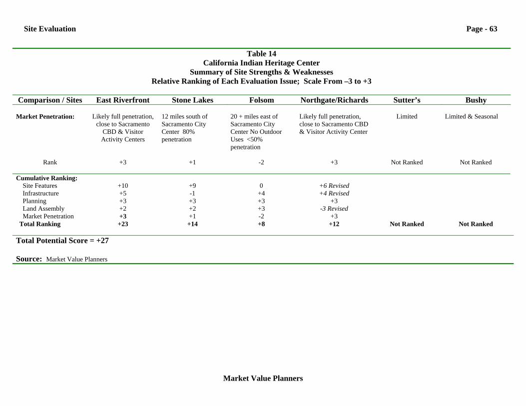
Site Evaluation Page - 63
Market Value Planners
Table 14 California Indian Heritage Center
Summary of Site Strengths & Weaknesses Relative Ranking of Each Evaluation Issue; Scale From –3 to +3
Comparison / Sites East Riverfront Stone Lakes Folsom Northgate/Richards Sutter’s Bushy
Market Penetration:
Rank
Likely full penetration,
close to Sacramento CBD & Visitor Activity Centers
+3
12 miles south of Sacramento City Center 80% penetration
+1
20 + miles east of Sacramento City Center No Outdoor Uses <50% penetration
-2
Likely full penetration, close to Sacramento CBD & Visitor Activity Center
+3
Limited
Not Ranked
Limited & Seasonal
Not Ranked
Cumulative Ranking: Site Features Infrastructure Planning Land Assembly Market Penetration Total Ranking
+10 +5 +3 +2 +3
+23
+9 -1 +3 +2 +1
+14
0
+4 +3 +3 -2 +8
+6 Revised +4 Revised
+3 -3 Revised
+3 +12
Not Ranked
Not Ranked
Total Potential Score = +27 Source: Market Value Planners
The Bushy Lake and Sutter’s Landing sites were removed form further consideration during a previous Task Force meeting and therefore have not been assigned individual or overall rankings. The identification of the East Riverfront site and the reconfiguration of the Northgate Richards split site gave rise to revisions contained in this report. The Northgate Richards split site would require locating the CIHC project on both sides of the American River and would result in substantial infrastructure cost to provide transportation access across the County drainage area and via a pedestrian bridge crossing the river. Land assembly has proved more challenging than originally represented during the 2004 site evaluation process. Additionally, the Richards Boulevard planning area is predominately light industrial in nature and would require substantial buffering from surrounding uses in order to create the intended ambiance for the CIHC concept.
Site Features The Stone Lakes and East Riverfront sites rank high on the basis of overall site features principally due to the availability of land, and the ability to provide a sense of place, separate from the urban setting. The Natoma Bluff site’s lack of adequate acreage absent the Willow Creek area places it at a distinct disadvantage in being able to support the full compliment of CIHC programs and activities. The uncertainty associated with land assembly at the Northgate Richards split site substantially reduces its attractiveness. However, the possibility of using portions of the original Northgate site for outdoor and extend prime season functions is an attractive if the main CIHC can be located in close proximity.
Infrastructure The East Riverfront, Natoma Bluff and Northgate sites rank high in terms of the accessibility of support infrastructure directly adjacent to the parcels, while Stone Lakes is disadvantaged by the 2.5-mile extension to reach sewer and water services, if eventually provided by the City.
Planning Environment Each of the sites is subject to a very complex, multi-jurisdictional planning environment and has been rated equally in the overall scheme. This element of comparison did not reveal any particular reason why the project might not be approved at any given site but insufficient information is available at this point regarding its physical features, scope and impact.
Land Assembly While Natoma Bluff was considered disadvantaged in terms of its amount of available land, it ranks highest in terms of potential to complete the land assembly through DPR
Site Evaluation Page - 65
Market Value Planners
and Bureau Of Reclamation. The inability to assemble portions of the Northgate site resulted in a revised negative ranking.
Market Penetration Because of the Northgate / Richards and East Riverfront site’s proximity to the Sacramento CBD and other visitor attractions they can be expected to achieve the highest level of market penetration, assuming sufficient land can be assembled to fully support the project concept. The Stone Lakes site, located 12 miles south of the Sacramento CBD could be a viable project as well but will remain at risk somewhat by its isolation form other visitor attractions and the concentration of visitor activity. Natoma Bluff receives a low ranking in visitor penetration in small part because of its distance from the metropolitan center but mostly due to its small site size and inability to support the full range of indoor and outdoor elements of the concept.
Conclusions Based on our analysis and ranking of each site’s comparative elements, the East Riverfront, site now leads in the overall ranking with a combined score of 23 points, ahead of the Freeport-Stone Lakes and revised Northgate Richards split sites with 14 and 12 points respectively. The Natoma Bluff, Folsom site has an 8 point combined score. While the developable land at the East Riverfront site may be somewhat limited during spring period, it offers the best available opportunity to fully implement the CIHC concept in comparison to the available site alternatives.
Other Factors The site evaluation methods and techniques applied in this report represent our effort to objectively and consistently measure the ability of candidate sites to support the CIHC concept, as presently articulated. The planning process is a feed-forward and feed-back endeavor. Every effort has been made to accurately and fully measure the features of each site. In the course of the evaluation, many assumptions have been made based on site sponsor data and representations. The actual availability of selected parcels material to the successful implementation of a CIHC project cannot be determined until negotiations have advanced significantly. The overall planning environment within which entitlement will ultimately be secured is complex for each site, involving extensive public review and comment. Should any or several of the assumptions regarding availability of land parcels at any site, the potential for entitlement or the availability of support systems prove to have been incorrect, a site with a high ranking may be replaced by a previously considered lower ranking site.

Site Evaluation Page - 66
Market Value Planners
Finally, other more community-based and overarching criteria could be appropriately applied in the site selection process that may compel the selection of a lower ranking site based on community support or other shared values.


![Ethnographic Photographs of California Indian and …pdf.oac.cdlib.org/pdf/berkeley/bancroft/p4690_cubanc.pdf[Identification of item], Ethnographic Photographs of California Indian](https://img.pdfslide.us/doc/110x75/5ea54bad244e0f3f4947ef38/ethnographic-photographs-of-california-indian-and-pdfoaccdliborgpdfberkeleybancroftp4690.jpg)