Embed Size (px)
Citation preview

Maritime communication challenges, and the ArcticSat IAP project

• Background from Norway and the maritime sector • Arctic • Some initial ideas for services

Communication, Observations, Situational Awareness, Human elements, Transport, Technology, Processes, Safety, Security, …..

On Site
Close Range
Long Range
Communication
Technologicalpossibilites
Application groups
Use
rgr
oups
Satellite
and Terrestrial
Sensors, W
iFi, M
obile
VH
F, H
F/M
F, W
iMA
X, ..
Traffic, e-Navigation, Surveillance, Operations
SAR, Monitoring, IO
Condition monitoring
Gov
ernm
ent,
Ope
ratio
nce
ntre
, Hyd
/Met
, etc
.
Pas
seng
ers,
Arc
ticO
pera
tors
Cre
wan
d pa
ssen
gers
Arctic Challenges
Source: Dr. Philip A. McGillivary, US Coast Guard
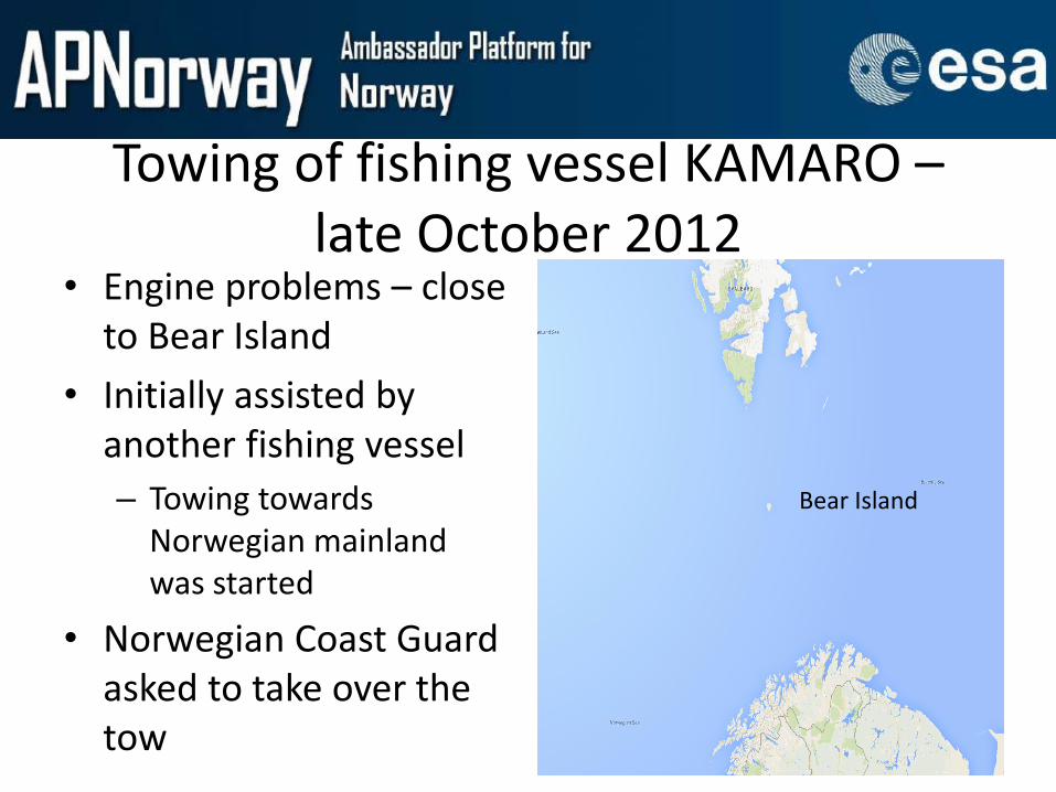
Towing of fishing vessel KAMARO – late October 2012
• Engine problems – close to Bear Island
• Initially assisted by another fishing vessel – Towing towards
Norwegian mainland was started
• Norwegian Coast Guard asked to take over the tow
Bear Island

Preparation on board NCG vessel HARSTAD
• The crew on NCG HARSTAD started planning the towing operation during the transit from Norwegian mainland to Bear Island
• They used experience from a similar situation as the baseline for their planning
• There had been a major change of crew since then


• A large part of Arctic maritime activities takes place in waters under Norwegian jurisdiction
Increased activity – more incidents?

SARiNOR On behalf of the Maritime Forum North and the SARiNOR project MARINTEK, SINTEF Fisheries and Aquaculture and SINTEF ICT completed work package 2 (WP2): Alerting and Notification. The focus of the work package was on how accidents reports today, analyses of requirements, technology and gaps within alerting and notification for "Search and Rescue" (SAR) services in the Norwegian sector.
The methodology behind this work consists of three main steps:
1. Collection of data on alerting and notification, including empirical knowledge from users, information technology and statistics about incidents
2. Any data collected is analysed to identify gaps and challenges with current systems and technology, and it is simultaneously made an assessment of risks related to notification and alerting
3. The results of the analysis are used to recommend measures, identify requirements for future systems, and to prioritize research and development tasks

• Basic map • Radio stations and
coverage – VHF/MF/HF public – DSC watch VHF/MF/HF – Coverage DSC VHF/MF
• Navigational aids – LORAN-C transmitters – CHAYKA transmitters – NAVTEX transmitters
• Vessel density – Month, type, zone
• Vessel accidents – Type, zone
• Combination • Reports

Recommendations: Alerting and Notification
Technological recommendations Easier functionality on emergency equipment, less information, standardization is important Too many different system (integration of systems, use of daily systems such as the chart plotter also for
alarm and notification) Receipt back to the sender of received alarm Position data as standard integrated in emergency equipment (suits, lifeboats, rafts, etc.) Higher focus on mobile equipment, also recommended regulated in to GMDSS New and better procedures for technical maintenances on equipment such as the emergency beacons Better procedures for maintenance of safety equipment, in order to avoid false alarms (in some contexts this
counts for more than 90% of the alarms)
Organization and human recommendations Use of 120-number, a service number, should be investigated. Frequently used within the leisure fleet in
Norway Better knowledge on communication limitations, should be part of the SAR-training courses. Better understanding of cultural differences as well as organizational barriers Establish procedures for vessels sailing in the northern waters, that not have the expertise on board Establish back-up resources regarding interpretation services

Activities in the ocean space

• The ArcticSat feasibillity structure

The Tender (topic and timing) The feasibility study is aimed at addressing the following needs expressed by the different user communities: 1. Reliable data provision regarding Arctic conditions and availability of
infrastructure, including ice thickness and dynamics, Arctic sea routes, seasonal forecasts, etc.
2. Reliable communication and positioning mechanisms, in particular broadband communications and positioning of ships and helicopters.
3. Monitoring mechanisms assessing the environmental impact of an increase in Arctic operations. Three space-based capabilities are relevant for integration into the potential services: • Earth Observation data: for assessment of ice conditions and
meteorology / sea-state. • GNSS signals: for tracking of ships and helicopters, and support to
search and rescue operations. • Satellite communications, covering the lack of terrestrial
infrastructure in many areas, and acting as an enabler of other services (data transmission, search and rescue, etc.).


Situational Awareness: Key elements

Situational Awareness in the Arctic Our own initial assessment suggests that situational awareness depends on three critical applications of space technologies, namely:
1. Effective communications to enable a complete virtual view of operations based on standards, compliant protocols and availability of all required data sources and information, allowing efficient and effective decision making, effectively mitigating the remoteness of the activities.
2. The ability to access existing and locally forecasted met-ice-ocean conditions (including hazards) over the field of operations, and upstream where potential hazards exist for dynamic risk assessment;
3. To monitor and be able to act upon the positions of all players, so that these can be deployed and monitored effectively for situational awareness, particularly in relation to efficiency and safety, emergency preparedness and compliance with relevant agreements and legislation.

Letter of Support • Norsk Romsenter

Lettor of Intent
• Maritime 21

Cover letter


Business cases
OIL Co Regional Centre
“Oil Spill” Service Provider
Satcom SP
Centre Supplier
Software
Supplier
National Rescue
Authorities
OIL Co
HQ
Oil Co Insurers
METEO
Services EO Services
EO Satellite System
UAV Sensor Processing
UAV
Leaser
Non SatCom SPs
Other Data Proc.
Other Supporting
Infrastructure
Mature
Emerging
Non-existent
OIL SPILL Application
METEO
Sensors
SHIPS or other crafts
e-Nav Service Provider
SatCom SP
e-Nav Hardware
Manufacturer
e-Nav Software
Manufacturer
SAR System SP
Rescue Authorities
Inmarsat SP
Inmarsat System
AIS System SP
EO Services
EO Satellite System
GNSS Services
Galileo
EGNOS Local
Other Communications
(e.g. VHF)
Other Services
Other Supporting
Infrastructure
Mature
Emerging
Non-existent
e-Navigation Application


![IAP antagonists sensitize murine osteosarcoma cells to ... · IAP activity within cells can be reduced by Smac/ Diablo, a natural IAP antagonist protein [14, 15]. A number of “IAP](https://img.pdfslide.us/doc/110x75/5c25d3f409d3f28d198c1460/iap-antagonists-sensitize-murine-osteosarcoma-cells-to-iap-activity-within.jpg)