Embed Size (px)
Citation preview

Point Reyes
")
")
")
")
")
")
")
")
")
")
")
")
")
")
")
")
1000'Closure
Point Reyes Headlands
122°58'0"W122°59'0"W123°0'0"W123°1'0"W38
°0'0"
N37
°59'0
"N37
°58'0
"N
North Central CoastStudy Region
North Central CoastStudy Region
Integrated Preferred Alternative for Special Closures
Marine Life Protection Act") Coastal Access Points
Proposed SMCAProposed SMPProposed SMRProposed SMRMASeasonal Special ClosureAll year special closure
This special closure area proposal was unanimously selected on April 23, 2008 by the MLPA Blue Ribbon Task Force (BRTF) as a component of its preferred alternative and is being submitted to the California Fish and Game Commission (CFGC) for consideration. This proposal integrates elements from three proposals developed by the North Central Coast Regional Stakeholder Group (NCCSRG) (proposals 1-3, 2-XA, and 4). The NCCRSG proposals will also be forwarded in their entirety to the CFGC for consideration. Further information on each closure proposal can be found in the associated text document with the same special closure proposal name.
May 07, 2008California Department of Fish and GameMarine Region GIS Lab,
°0 0.5
Miles
Point Resistance
")
")
")
")
")
")
")
")
")
")
")
")
")
")")
")
")
")
")
")
")
")
")
")
")
")
")
")
")
")")
")
")
")
")
300'Closure
122°49'0"W122°50'0"W122°51'0"W38
°1'0"
N38
°0'0"
N37
°59'0
"N
North Central CoastStudy Region
North Central CoastStudy Region
Integrated Preferred Alternative for Special Closures
Marine Life Protection Act") Coastal Access Points
Proposed SMCAProposed SMPProposed SMRProposed SMRMASeasonal Special ClosureAll year special closure
This special closure area proposal was unanimously selected on April 23, 2008 by the MLPA Blue Ribbon Task Force (BRTF) as a component of its preferred alternative and is being submitted to the California Fish and Game Commission (CFGC) for consideration. This proposal integrates elements from three proposals developed by the North Central Coast Regional Stakeholder Group (NCCSRG) (proposals 1-3, 2-XA, and 4). The NCCRSG proposals will also be forwarded in their entirety to the CFGC for consideration. Further information on each closure proposal can be found in the associated text document with the same special closure proposal name.
May 07, 2008California Department of Fish and GameMarine Region GIS Lab,
°0 0.5
Miles
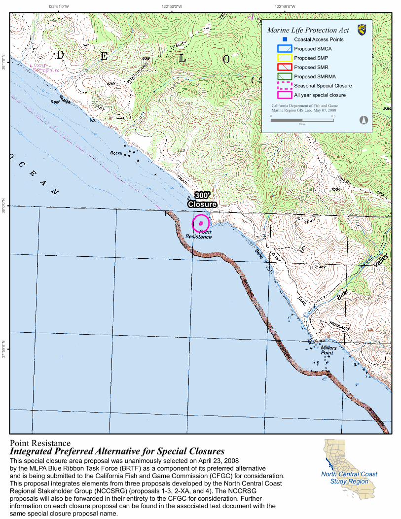
Stormy Stack
")
")
")
")
")
")
")
")
")
")
")
")
")
")
")
")
")
")
")
300'Closure
122°46'0"W122°47'0"W122°48'0"W37
°58'0
"N37
°57'0
"N37
°56'0
"N
North Central CoastStudy Region
North Central CoastStudy Region
Integrated Preferred Alternative for Special Closures
Marine Life Protection Act") Coastal Access Points
Proposed SMCAProposed SMPProposed SMRProposed SMRMASeasonal Special ClosureAll year special closure
This special closure area proposal was unanimously selected on April 23, 2008 by the MLPA Blue Ribbon Task Force (BRTF) as a component of its preferred alternative and is being submitted to the California Fish and Game Commission (CFGC) for consideration. This proposal integrates elements from three proposals developed by the North Central Coast Regional Stakeholder Group (NCCSRG) (proposals 1-3, 2-XA, and 4). The NCCRSG proposals will also be forwarded in their entirety to the CFGC for consideration. Further information on each closure proposal can be found in the associated text document with the same special closure proposal name.
May 07, 2008California Department of Fish and GameMarine Region GIS Lab,
°0 0.4
Miles
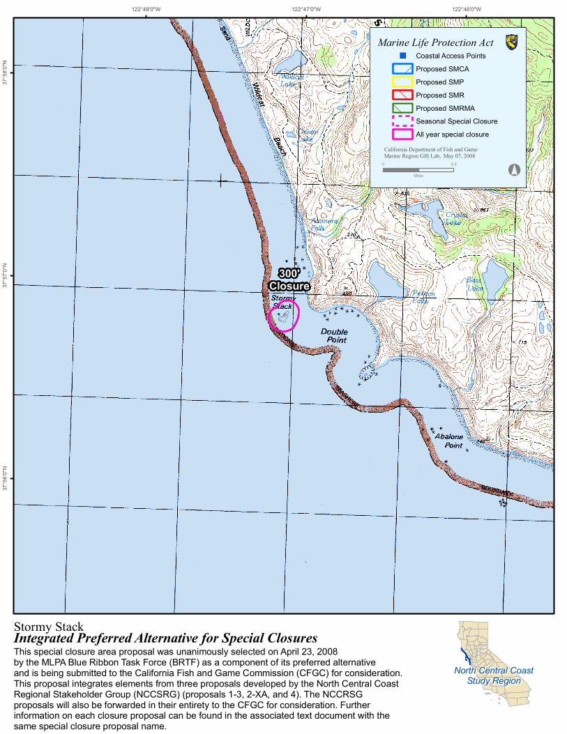
Egg Rock (Devil's Slide)
")
")
")
")
")
")
")
")
")
")
")
")
")
")
")
")
")
")
")
")
")
")
")
")
")
")
")
300' Closure - west of Egg rock1000' Closure - east of Egg rock
Pedro Point Headlands
San Pedro Beach
Gray Whale Cove State Beach
122°30'0"W122°31'0"W122°32'0"W37
°36'0
"N37
°35'0
"N37
°34'0
"N
North Central CoastStudy Region
North Central CoastStudy Region
Integrated Preferred Alternative for Special Closures
Marine Life Protection Act") Coastal Access Points
Proposed SMCAProposed SMPProposed SMRProposed SMRMASeasonal Special ClosureAll year special closure
This special closure area proposal was unanimously selected on April 23, 2008 by the MLPA Blue Ribbon Task Force (BRTF) as a component of its preferred alternative and is being submitted to the California Fish and Game Commission (CFGC) for consideration. This proposal integrates elements from three proposals developed by the North Central Coast Regional Stakeholder Group (NCCSRG) (proposals 1-3, 2-XA, and 4). The NCCRSG proposals will also be forwarded in their entirety to the CFGC for consideration. Further information on each closure proposal can be found in the associated text document with the same special closure proposal name.
May 07, 2008California Department of Fish and GameMarine Region GIS Lab,
°0 0.5
Miles
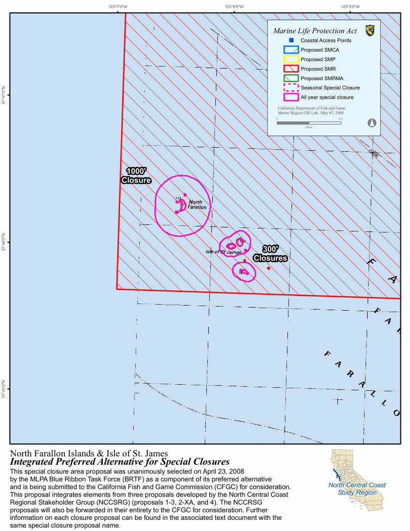
North Farallon Islands & Isle of St. James
300'Closures
1000'Closure
123°5'0"W123°6'0"W123°7'0"W37
°47'0
"N37
°46'0
"N37
°45'0
"N
North Central CoastStudy Region
North Central CoastStudy Region
Integrated Preferred Alternative for Special Closures
Marine Life Protection Act") Coastal Access Points
Proposed SMCAProposed SMPProposed SMRProposed SMRMASeasonal Special ClosureAll year special closure
This special closure area proposal was unanimously selected on April 23, 2008 by the MLPA Blue Ribbon Task Force (BRTF) as a component of its preferred alternative and is being submitted to the California Fish and Game Commission (CFGC) for consideration. This proposal integrates elements from three proposals developed by the North Central Coast Regional Stakeholder Group (NCCSRG) (proposals 1-3, 2-XA, and 4). The NCCRSG proposals will also be forwarded in their entirety to the CFGC for consideration. Further information on each closure proposal can be found in the associated text document with the same special closure proposal name.
May 07, 2008California Department of Fish and GameMarine Region GIS Lab,
°0 0.5
Miles
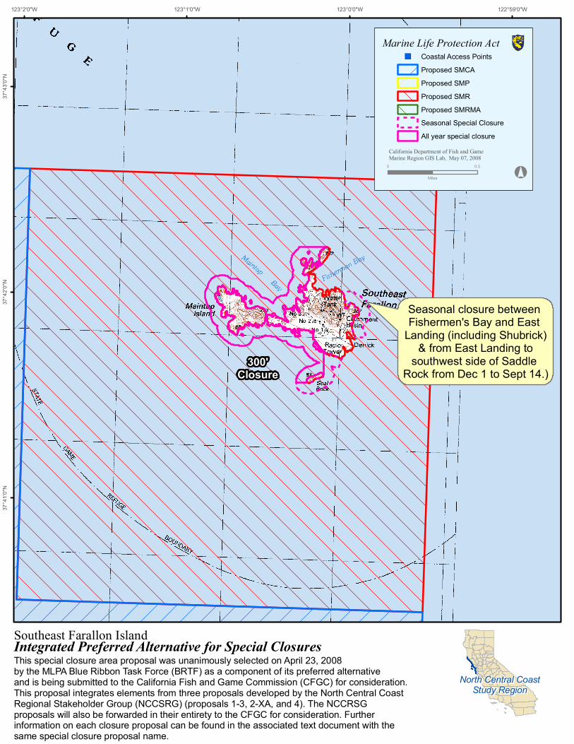
Southeast Farallon Island
Seasonal closure between Fishermen's Bay and East
Landing (including Shubrick) & from East Landing to
southwest side of Saddle Rock from Dec 1 to Sept 14.)
300'Closure
122°59'0"W123°0'0"W123°1'0"W123°2'0"W37
°43'0
"N37
°42'0
"N37
°41'0
"N
North Central CoastStudy Region
North Central CoastStudy Region
Integrated Preferred Alternative for Special Closures
Marine Life Protection Act") Coastal Access Points
Proposed SMCAProposed SMPProposed SMRProposed SMRMASeasonal Special ClosureAll year special closure
This special closure area proposal was unanimously selected on April 23, 2008 by the MLPA Blue Ribbon Task Force (BRTF) as a component of its preferred alternative and is being submitted to the California Fish and Game Commission (CFGC) for consideration. This proposal integrates elements from three proposals developed by the North Central Coast Regional Stakeholder Group (NCCSRG) (proposals 1-3, 2-XA, and 4). The NCCRSG proposals will also be forwarded in their entirety to the CFGC for consideration. Further information on each closure proposal can be found in the associated text document with the same special closure proposal name.
May 07, 2008California Department of Fish and GameMarine Region GIS Lab,
°0 0.5
Miles


![0 1. .2 )1+3 (/4 $+.5+6 7 ! 8 9 +: );) *+( # + 6 .%< $/) *++dfg.ca.gov/mlpa/pdfs/draft_dive.pdf[!4 / -#6 1 +2N '& $, ? 5 :3 0C % H@ 7 F 4 $5#2&$6 +$ -!W" ++% &2-H:!+-!1,)!]^^[X!!!](https://img.pdfslide.us/doc/110x75/5aa3bca07f8b9a07758ea975/0-1-2-13-4-56-7-8-9-6-dfgcagovmlpapdfsdraftdivepdf4.jpg)