Embed Size (px)
Citation preview

Marine Character Areas
MCA 18
WEST PEMBROKESHIRE COASTAL WATERS & ISLANDS
MCA 18 West Pembrokeshire Coastal Waters & Islands - Page 1 of 9
Location and boundaries
This Marine Character Area (MCA) covers the most western part of Wales, stretching from Strumble Head in the east to the tip of St Anne’s Head to the south.
It includes the islands of Ramsey, Skomer and Skokholm which frame St Bride’s Bay.
The outer MCA boundaries are guided by bathymetry and other navigational information marked on the Marine Charts, including areas of rough sea, overfalls and tidal streams related to the islands and Strumble Head.
The MCA comprises the marine elements of the following Pembrokeshire local Seascape Character Areas: 11, 13, 15, 16, 17, 18, 20, 21, 22, 23, 24, 25, 26 and part of 29.
MCA 18 West Pembrokeshire Coastal Waters & Islands - Page 2 of 9
Key Characteristics
Key Characteristics
Diverse and spectacular coastline with rugged steep cliffs up to 140m AOD punctuated by sandy foreshores steep narrow valleys, harbours and isolated bays.
St Brides Bay is a broad sweeping bay with a westerly aspect, gently falling away from the beaches at Newgale Sands and Broad Haven.
The islands of Skomer, Skokholm, and Ramsey mark the entrance to St Bride’s Bay. Each has its own unique characteristics with an array of coastal features including rocky shores, stacks, arches, caves and small coves.
St David’s peninsula is backed by the highly prominent landform of Carn Llidi: an abrupt rocky volcanic outcrop.
Hazardous seas around the islands with strong tidal streams, races and eddies, along the Ramsey Sound which forms a north-south tidal sea passage and at the northern entrance of Jack Sound, to the west of Skomer.
Biodiverse waters and coastline for birds, porpoises and seals. Skomer is designated as a Marine Nature Reserve and MCZ; Skokholm NNR is an important bird sanctuary.
Subtidal rocky reefs, large shallow bays, sandflats and caves are some of the habitats that create such rich marine environment within part of the Pembrokeshire Marine SAC.
Exposure to westerly and southerly winds, with strong surf over long shallow beaches. The MCA’s position affords shelter to northerlies. Drying or submerged rocks are shipping hazards.
Shipwrecks and downed WWII aircraft illustrate the area’s dangerous sea conditions and help tell the story of its important role in 20th century conflicts.
Strong sense of time depth, including one of the best preserved prehistoric settlements in Wales on Skomer Island, along with hillforts on Garn Fawr, coastal promontory forts and ancient settlement remains at St David’s Head.
Importance of small harbours such as Solva, Porthstinian, Porthgain and slipways at Broad Haven and Martin’s Haven.
Home of St David, the patron saint of Wales who lived here in the fourth century. The St David’s Peninsula is one of the most significant culturally historic and esteemed landscapes in Wales.
Rich seas attract much fishing activity, including beach seining, set nets, lobster and crab potting.
The MCA is used by commercial ships anchoring while waiting to access Milford Haven. The Fishguard ferry passes nearby within MCA 19.
Popular coastline and marine area for a range of recreational activities. Sandy coves including Whitesands Bay and broad expanses at Broad Haven and Newgale Sands provide visitors with the opportunity to access the sea for watersports.
Numerous coastal settlements acting as key landmarks; the lighthouse on Skokholm is also a strongly associated coastal and maritime feature – both in the day and at night.
The largely inaccessible north coast means that Strumble Head and its lighthouse are a key attraction for visitors.
Uninterrupted vistas define character, including to famous cliffs, islands (Ramsey, Skomer and the Bishops) and open sea from several high viewpoints –accessible via the Coast Path.

MCA 18 West Pembrokeshire Coastal Waters & Islands - Page 3 of 9
Natural Influences
The West Pembrokeshire Coastal Waters and Islands MCA covers the most western part of Wales, stretching from Strumble Head in the east to the tip of St Anne’s Head to the south. The waters are backed by an intricate coastline heavily influenced by powerful Atlantic waves, leaving steep jagged cliffs, rocky coves, exposed islands and sandy bays. Frequent headlands, exposed rocky shores and secluded narrow bays are backed by steep rising landform at Garn Fawr, Penberry, Carn Llidi, as well as Carnllundain on Ramsey Island – creating a visually distinct coastline and foreground to Pembrokeshire Coast National Park. The islands of Ramsey and Skomer define the outer edges of the west-facing St Brides Bay, marking the entrance like sentinels on guard. The MCA’s exposed aspect sees the area take the full force of prevailing south-westerlies, facing the brunt of weather sweeping in from the Irish Sea.
Ramsey Island viewed across the strong tidal races within Ramsey Sound
High wave energy is experienced throughout the MCA, with the greatest wave intensity felt along the north coast from Strumble Head to Ramsey Island, within St Brides Bay and along the shore at Marloes Sands, in the south. The gently sloping west-facing beaches are known for moderately large waves, a particular draw for surfers. Tidal currents set north and south at the edge of the St Brides Bay, and north-east and south-west off the north coast up to Strumble Head at a rate of up to three knots. There is a westerly counter-eddy on the east stream between Strumble Head and Penbrush, with rough waters off headlands. Strong reverse eddies are also experienced at Horse Rock in Ramsey Sound, and at Skomer.
The tidal races within Ramsey Sound are particularly strong, reaching six knots on spring tides. The unique currents and sheltered position of the Sound have led to it being chosen as a test site for a temporary tidal renewable energy installation. At the Bitches, strong currents run over the submerged rocks to create a phenomenon of a standing wave occasionally reaching approximately one metre high, also known as a big ‘wave train’ to kayakers. Numerous navigation buoys, lit cardinal markers, Strumble Head Lighthouse and Skokholm Lighthouse provide guidance to vessels travelling through the MCA’s dangerous seas. The latter lighthouse forms the landward corner of a triangle of lights, the others being South Bishop and the Smalls (MCA 19), guiding ships clear of this particularly

MCA 18 West Pembrokeshire Coastal Waters & Islands - Page 4 of 9
treacherous stretch of coastline into Milford Haven (MCA 21) or up the Bristol Channel (MCA 28).
Bathymetry varies within the MCA with the deepest waters found within the channel of the Ramsey Sound, where it plummets to a depth of 66 metres, with a further area of deeper water around Skomer reaching 54 metres off its western side. The sea floor gradually shelves on a bedrock of mudstone and sandstone, falling more steeply off Strumble Head. Bands of slate extend out from St David’s peninsula enclosing Ramsey Island, and from Marloes peninsula offshore taking in Skomer Island. Holocene-derived sand and gravel sediments cover the seafloor, with a large pocket of muddy-sand in the centre of St Brides Bay. Exposures of intertidal peats and forest stumps have been discovered at Newgale South Sands, providing evidence of an ancient now partially submerged landscape.
The adjacent coastline displays a rich geological mix. Towering over the north of St Bride’s Bay stand faulted Precambrian and Cambrian tuff, sandstone and mudstone cliffs, similarly outcropping at Ramsey Island. Bays, inlets and deeply incised valleys punctuate the outcrops leaving rocky promontories, stacks, arches, blowholes and boulder-strewn foreshores. Bands of weaker Middle Coal Measures create the wide sandy beaches within St Bride’s Bay. To the south, Old Red Sandstone cliffs define the coastline and the Skokholm islands. Skomer, Midland Isle and Strumble Head are sculpted out of the remains of volcanic igneous rock formations.
The waters and varied coastline of the MCA are highly designated for their valuable semi-natural habitats supporting diverse marine and coastal wildlife. These include porpoises and dolphins, as well as the largest breeding Atlantic grey seal colony in southern Britain (400 pups born along the local coastline each year). Specific designated sites include the Pembrokeshire Marine SAC, Skokholm and Skomer SPA and Skomer Island and Middleholm SSSI. Skomer Marine Nature Reserve (MNR), established in 1991, is the only MNR in Wales covering the island and the Marloes Peninsula. Conservation priorities include protecting populations of pink seafan, seaslugs, eelgrass and algal communities. Skomer is also home to one of the most important seabird sites in southern Britain, accommodating one of the largest Manx shearwater colonies in the world, along with a significant proportion of the total UK population of puffin, storm petrel, guillemot and razorbill populations.
Ramsey Island NNR and SSSI also is also nationally important for its populations of breeding seabirds, with cliffs up to 120 metres high providing nesting sites for choughs, razorbills, fulmars and peregrine. Bluebell, pink thrift and purple heather cover the slopes of Carn Llundain, providing important maritime heathland habitat and a variety of colour within the island seascape. Further along the coast, St David’s Head SAC is designated for its vegetated sea cliffs and European dry heaths. The Pembrokeshire Cliffs Important Bird Area also covers the same section of cliffs, also in reflection of the varied sea bird populations found there.
Cultural/social influences
This MCA is one of the most significant cultural landscapes in Wales. St David’s peninsula is the 4th century home of St David, the patron saint of Wales, and combined with Ramsey Island, is nationally designated as a Landscape of Outstanding Historic Interest. Whitesands Bay has historic links with Ireland – the beach used for boat embarkations and arrivals and supposedly the landing place for pilgrims coming from Ireland during the early medieval period. Immediately behind the beach at Whitesands are the remains of the medieval St Patricks Chapel and its associated cist graves – the physical expression of this long-held tradition of sanctity and now subject to archaeological investigation in advance of coastal erosion.
Skomer Island is also a Landscape of Outstanding Historic Interest due to its rich historical remains, including prehistoric field systems and settlement evidence. Along the north-

MCA 18 West Pembrokeshire Coastal Waters & Islands - Page 5 of 9
facing coast of the mainland, Garn Fawr and Strumble Head form part of a Landscape of Special Historic Interest for their collection of Neolithic chamber tombs, early Christian sites and medieval settlements – many occupying commanding positions overlooking the sea.
Historic coastal quarrying has also left its mark along the coastline, particularly associated with Abereiddi and Porthgain during the late 19th and early 20th centuries. Evidence of this coastal industry remains all along the cliff-tops between the settlements. Slate, granite and brick were shipped out of Porthgain’s harbour – large, nationally designated brick hoppers, used to store crushed dolerite before shipment, dominate the harbour – the dolerite exported for use as road stone in the early 1900s. At Abereiddi, the iconic ‘Blue Lagoon’ is also a product of quarrying, though now best-known as an attraction for coasteering.
The open nature of St Brides Bay and its gently shelving seabed has been kind to recent generations of mariners with few wrecks being recorded here. Records show that during the early periods when sail-power predominated, ships could become embayed on prevailing westerly winds – driven ashore at Newgale Sands and Broad Haven. The waters surrounding the MCA’s islands are not so forgiving. Here boats using the Sounds to avoid the treacherous waters between The Smalls and Grassholm (MCA 19) can be caught out by the strong tidal races, shoals and submerged rocks. Horse Rock, just east of the central channel in Ramsey Sound, is of particular note – causing the grounding of several vessels including the Magella (1991), Guiding Star (1885) and Count D’Aspremont (1903). St Bride’s Bay includes Pembrokeshire’s most popular wreck dive site - Lucy, which foundered off North Haven, Skomer, after running aground when passing through Jack Sound in 1967. Further documented losses also include downed wartime aircraft linked to the presence of the military airfields and associations with the Battle of the Atlantic. One such example these crashed into the base of the rocky outcrop of Carn Llidi in 1943; the event remembered on a memorial at Whitesands Bay. The slopes of Carn Llidi are also home to the remains of the WWII cliff defences and ‘Highwinds’, a submarine listening post.
Generally there is limited access for boats due to the lack of large ports or marina facilities. However, there are a number of small harbours and slipways dotted along the coastline in the bays and inlets (such as Porth Clais, Solva Harbour and Martin’s Haven). Porthgain and Abercastle operate their own long-standing inshore fishing fleets. Fishing activity today comprises lobster and crab potting across the whole MCA with some whelk potting within St Brides Bay. Hand gathering of mussels and periwinkles takes place at Druidston Haven and Solva, plus beach netting along the sandy foreshores within St Brides Bay. Handlines, light otter trawling and set nets are used across the whole area apart from around the islands. Hydraulic dredging for aggregates takes place within St Brides Bay, apart from within a large channel used as a Research Area. This part of the bay contains oceanographic instruments, with vessels cautioned against anchoring here.
The coastal edge benefits from good recreational opportunities within the Pembrokeshire Coast National Park, including access via the Pembrokeshire Coast Path and Puffin tourist shuttle bus. The extensive sandy beaches at Whitesands Bay, Broad Haven, Marloes Sands and the shingle-backed beach at Newgale attract large visitor numbers. Water sports are popular in the bays, with sailing dinghies and jet-skies launched directly from the beaches.
Sea cliffs provide opportunities for climbers, and viewing opportunities for observing the rich bird and marine wildlife. The wildlife and large bird colonies of the islands, as documented by the naturalist Ronald Lockley, attract large numbers of tourists with frequent boat trips leaving from the small local harbours. The Grade II Listed Strumble Head lighthouse (1908) on Ynys Meicel - constructed to guide vessels entering Fishguard Harbour in MCA 16 (including the ferry from Ireland) – also provides as a key draw for visitors along this otherwise undeveloped coastline.
MCA 18 West Pembrokeshire Coastal Waters & Islands - Page 6 of 9
Aesthetic and perceptual qualities
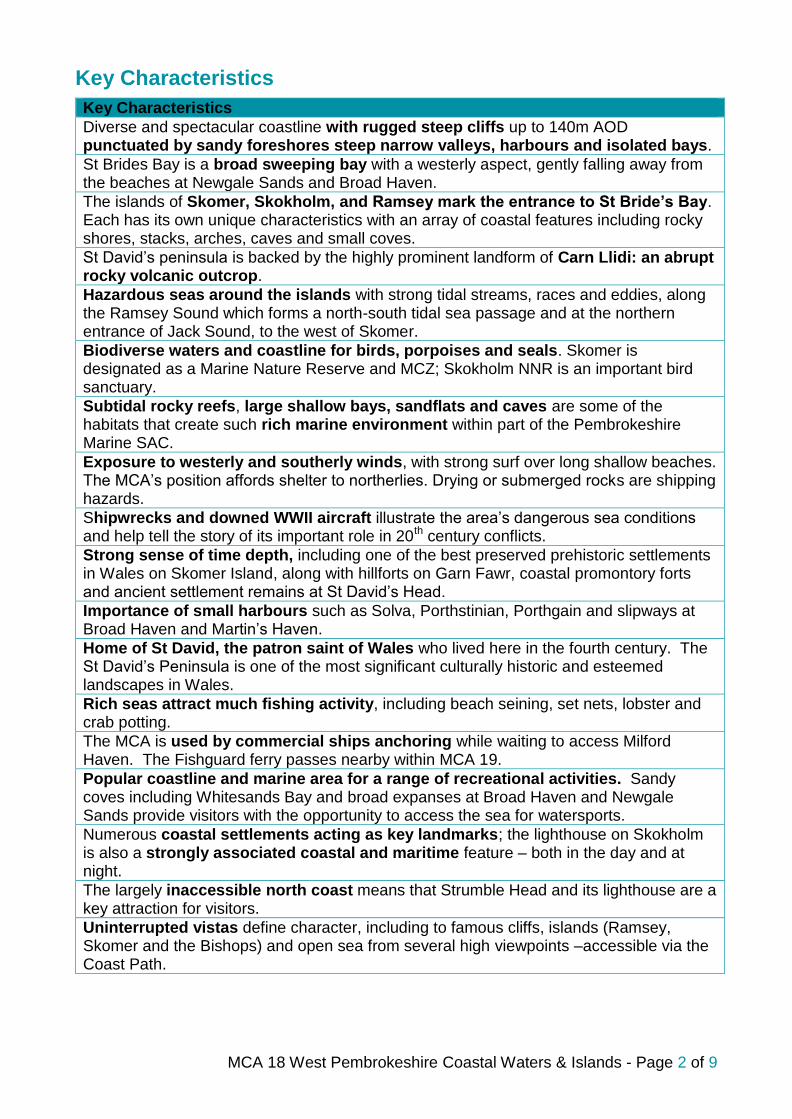
This most westerly point of Wales is exposed to the elements with strong feelings of tranquillity, with a wild undisturbed coast away from the popular beach destinations. The surf crashes onto the beaches and into the foot of cliffs, producing an exciting and stimulating environment. Large sections of the coast feel rural and remote with the shoreline virtually inaccessible in some places, especially to the north. Tranquillity can be reduced in summer by the numbers of visitors attracted to the nationally designated coastal landscape. Generally there is a lack of light pollution though, producing dark night skies.
Newgale Sands beach, with rough seas exposed to westerly winds
Local coastal scenes and waterscapes have been popular with artists over the centuries. Graham Sutherland painted pictures of the coves leading to St David’s Head, as did Rev. Thomas Raven who also painted St Bride’s Bay in the early 19th century. John Piper is associated with the north coast, having lived in a cottage by Garn Fawr and painted many local sea and coastal scenes. Poetry forms an important part of the area’s identity. Local poet and “Clockwinder” W.H. Williams wrote from Marloes Village, musing about “The broad Atlantic, and ships sailing the sea. I see the Islands, and of lighthouses three.” There is a memorial to Dewi Emrys who wrote the poem ‘Pwll Deri’ about the local area of Strumble Head.
Views from the northern coastal section are characterised by uninterrupted vistas, with occasional views of the Rosslare or Waterford to Fishguard ferries travelling through Cardigan Bay. In the west, the islands feature heavily in views being overlooked from the mainland. Ramsey, Skomer and Skokholm are all an integral part of sea views from the coastline, with distant views gained to the Bishops and Clerks (MCA 19) on the horizon. Strong intervisibility between the north and south cliffs enclosing St Brides Bay can be gained from the numerous headlands. The elevated peaks of Carn Llidi and Garn Fawr provide opportunities for panoramic views of the coastline; the view from Carn Llidi to Ramsey Island known as an iconic National Park view. Carn Llidi was used as a submarine lookout post in WWII, however today views of moored tankers and large cargo ships are more likely as they wait entry into Milford Haven (MCA 21).
From the water, the dark grey and red sloping cliffs form a distinctive setting, along with the islands and the conical peaks of Carn Llundain and Carn Llidi. On passage from

MCA 18 West Pembrokeshire Coastal Waters & Islands - Page 7 of 9
Ireland, Garn Fawr can be seen well before Strumble Head lighthouse, although in the evening the light from Strumble Head Lighthouse is apparent in the distance.
Stumble Head Lighthouse
The Visual Resource Maps (VRM) that follow provide a more detailed spatial representation of the visibility of this MCA from the surrounding land in Wales. Please refer to the technical report for an explanation of how these maps were generated and how they should be interpreted. The first map shows land with views to this MCA, the darker shading indicating land where from which more of this MCA is visible. The second map shows sea visible from land, the warmer colours being areas of sea that are visible from more places on land. This comes from a national assessment of Wales so the results do not relate specifically to this MCA, whose boundary is overlaid for location only. The four individual versions show how the results vary depending on how far inland hypothetical viewers are located.

Map Scale @ A4: 1:350,000
18: West Pembrokeshire Coastal Waters and IslandsWales Inshore Marine Plan Area
© British Crown and OceanWise Ltd, 2015. All rights reserved License No. EK001-20120402© Crown copyright and database rights 2015 Ordnance Survey 100019741© Hawlfraint y Goron a hawliau cronfa ddata 2015 Arolwg Ordnans 100019741
CB: EB:Goosen_V LUCLON 6262-00_021_VRM_Maps_DDP_LandWithSeaViews_export_map_1 25/03/2015
Source: LUC, NRW, OceanWise
Wales National Seascape Assessment
0 5 10kmE
Land with Views of:
Wa l e
s
MCA 18: WestPembrokeshire CoastalWaters and Islands
Land with sea views (Percentile)< 20 (Lowest)21 - 4041 - 6061 - 8081 - 100 (Highest)

Map Scale @ A4: 1:410,000
18: West Pembrokeshire Coastal Waters and IslandsWales Inshore Marine Plan Area
© Brit ish Crown and OceanWise Ltd, 2015. All rights reserved License No. EK001-20120402© Crown copyright and database rights 2015 Ordnance Survey 100019741© Hawlfraint y Goron a hawliau cronfa ddata 2015 Arolwg Ordnans 100019741
CB: EB:Goosen_V LUCLON 6262-00_022_VRM_Maps_DDP_Sea_Visib ility_ 27/05/2015Source: LUC, NRW, OceanWise
Wales National Seascape Assessment
0 5 10kmE
Relative Visibility of theSea Surface from Viewerson Land
Wa
l es
MCA 18: WestPembrokeshire CoastalWaters and Islands
0-1 km from High Water Mark 1-5 km from High Water Mark
5-10 km from High Water Mark 10-20 km from High Water Mark
Visibility of sea from land (percentile)<10 (Lowest)11-2021-3031-4041-50
51-6061-7071-8081-9091-100 (Highest)