Embed Size (px)
Citation preview

Best practice guidance for assessment, evaluation and monitoring of the possible effects of marine aggregate extraction on the coast – a Coastal Impact Study
December 2013
Marine aggregate dredging and the coastline: a guidance note

2
2.1 The importance of the coast
Contents
1 Aim of this guidance note – p5
2 Introduction – p6
2.1 The importance of the coast – p6
2.2 Characteristics and origins of our coastline – p12
2.3 Marine aggregate extraction around the UK coastline – p16
3 Regulatory context and environmental impact assessment in England and Wales – p18
4 Coastal Impact Studies: overall approach – p21
4.1 Introduction – p21
4.1.1 Definition of the coastal zone and limits of the CIS – p21
4.2 General methodology for a Coastal Impact Study – p22
4.3 Guiding principles – p25
4.4 Assessment criteria – p26
5 Assessment methods: technical review – p29
5.1 Introduction – p29
5.2 Changes in nearshore wave conditions – p29
5.2.1 Physical processes – p29
5.2.2 Information required – p29
5.2.3 Assessment methods – p30
5.3 Changes in nearshore tidal currents – p31
5.3.1 Physical processes – p31
5.3.2 Information required – p32
5.3.3 Assessment methods – p32
5.4 Beach and sandbank draw-down – p32
5.4.1 Physical processes – p32
5.4.2 Information required – p33
5.4.3 Assessment methods – p33
5.5 Changes in sediment transport and supply patterns – p34
5.5.1 Physical processes – p34
5.5.2 Information required – p34
5.5.3 Assessment methods – p34
6 Consideration of cumulative impacts – p36
6.1 Definition – p36
6.2 Assessment methods – p36
7 Consideration of in-combination impacts – p37
7.1 Definition – p37
7.2 Assessment methods – p37
8 Interpreting a Coastal Impact Study – p38
8.1 Synthesising a Coastal Impact Study – p38
8.2 Interpreting the Coastal Impact Study assessments – p38
9 Mitigating predicted impacts on the coastline – p42
10 Reporting – p43
11 Monitoring – p44
12 References – p49
Appendix Sources of coastal impact assessment data – p50
This document has been produced in consultation with the
Marine Management Organisation, Natural Resources Wales,
Natural England, JNCC, the Environment Agency, English
Heritage, Cefas, HR Wallingford and ABPmer.
The opinions expressed in this report do not necessarily
reflect the views of these organisations nor are they intended
to indicate how any individual organisation will act on a
given set of facts or signify any preference for one assessment
approach or methodology over another.
Cover photo: © Alan Hunton.3

4 5
1. Aim of this guidance note
This note provides best practice guidelines on carrying out a Coastal Impact Study (CIS) as part of an application to dredge marine
aggregates from the seabed around the English and Welsh coasts. As adverse changes to the coast arising from marine aggregate
dredging would be clearly unacceptable in all but exceptional circumstances (for example a national emergency), the assessment
of potential physical effects on coastlines forms a key part of the Environmental Impact Assessment of marine aggregate dredging
proposals on a case-by-case basis. The Government policies on marine mineral extraction are defined in the UK Marine Policy
Statement (HM Government, 2011), and as a consequence decision makers will normally require a CIS to comprehensively assess
the possible coastal effects of dredging applications by considering potential changes in waves, currents and sediment transport
as part of an Environmental Impact Assessment.
This guidance note, which has been developed by the British Marine Aggregate Producers Association and The Crown Estate
from well established approaches to assessing coastal impacts, seeks to establish best practice for the British marine aggregate
industry and advises on the scope, standards and transparency that are expected in a CIS. It is designed to be a valuable reference
providing mutual benefit to all stakeholders and consultees, including dredging companies, consultants, government regulators
and agencies, local authorities, NGOs, other seabed and coastal users and the public. Both defended and natural coastlines are
considered through this process.
To ensure consistency, this note outlines the terms of reference and essential elements of a CIS; including the data required
to undertake a study, key components and their analysis, consideration of cumulative and in-combination impacts, as well as
mitigation and monitoring options. Additionally, this guidance note should be read in conjunction with the “Marine Aggregate
Terminology: A Glossary” document, produced by BMAPA and The Crown Estate (2010).
A detailed glossary of terms associated with the assessment and management of marine aggregate dredging operations is available at www.bmapa.org

6 7
2.1 The importance of the coast
This guidance initially describes our coastline, then marine aggregate extraction and the regulatory regime associated with
permitting dredging. This is followed by a detailed consideration of the CIS methodology, resulting in identification and
assessment of key sensitivities. Interpretation of results, potential mitigation opportunities and monitoring are also reviewed.
Coastlines naturally provide protection to us from the waves and physical process occurring in the marine environment and
from flooding. They are constantly evolving and adapting to the natural conditions they experience and form part of the natural
environment that we all occupy. Some natural habitats rely on regular flooding / erosion to maintain their environmental function
whilst others are particularly sensitive to changes. In areas where the current form of the coast is necessary to protect natural
ecological or social functions, engineered solutions using hard (built) or soft (adapted) protection measures may be required.
Whilst marine aggregate can form part of the hard and soft engineering solution to some of the issues facing our coastlines, it also
has the potential to change the natural processes occurring at the coast. It is therefore important that any proposed aggregate
extraction does not adversely affect the appearance or function of the coast, or contradict the national policy set out in shoreline
management plans.
Note that for the purposes of this guidance note, it is assumed that the policy at all points of the coast is to ‘hold the line’. This
ensures that potential effects occurring at the coast are assessed conservatively, ensuring that no unacceptable changes will occur
as a result for the duration of the dredging permission.
2.1 The importance of the coast
The continual changes of the UK coastline, whether natural or man-made, result in economic, social and environmental impacts
on a significant scale affecting jobs, developments, communities, individuals and their quality of life. As a consequence, there
is substantial investment in the management of the coast, for example, to reduce the risks of flooding and erosion, to maintain
coastal infrastructure and to protect or enhance natural environments.
Around 33 per cent of the population live in communities lying at or around sea level (Environment Agency, 1999); and businesses
in the coastal zone make a significant tangible economic contribution to the nation’s GDP. Whilst coastal communities flourish,
the significant costs, methods and wider strategies that protect the existing coastline from erosion and flooding must adapt to the
developing threat posed by climate change. The latest shoreline management plan documents highlight the strategic planning
for climate change along each section of the coast. The amenity and leisure value associated with the coast is important to a wide
variety of stakeholders - both onshore and immediately offshore - including tourists, sporting enthusiasts, recreational anglers,
boating enthusiasts and divers.
The coast around England and Wales is a defining feature of our country. Our emotional attachment ranges from the windswept
beaches of East Anglia to imposing chalk cliffs of Sussex and to the beaches of the Isle of Wight. Estuaries, such as the Humber,
Severn and the Dee, complement the diverse and dynamic range of coastal environments in the areas close to where marine
aggregate dredging takes place. Representative examples of some of the range of these diverse coastal features are shown in
Figures 1-10.
At the same time, our varied coastal ecosystems contribute to the diverse range of habitats and species and their importance
is recognised in the number and range of nature conservation designations around the coast. Some of these habitats rely on
the natural erosional and depositional processes that have been occurring naturally around our coasts for thousands of years. In
addition, the historic environment makes a unique contribution to the character of our coastal areas, from evidence of our human
ancestors dated to c. 900,000 years ago at Happisburgh, to a wide variety of 20th century military defensive structures.
Changes to the coast arising from marine aggregate dredging in addition to those already occurring naturally and through other
man-made interference, would only be acceptable in exceptional circumstances, for example a national emergency.
FIguRE 1: A naturally eroding low-lying coastline composed of glacial sediments (Holderness, East Riding of Yorkshire)
A sand and gravel beach lies in front of a cliff line composed of geologically soft glacial till. At high water, waves break at the base
of the cliff line eroding the soft sediment and causing the coastline to retreat locally resulting in loss of farmland, buildings and
other infrastructure. The sand and gravel released from the eroding cliffs is transported along the coastline towards a natural sink
(in this case south towards Spurn Head spit, at the mouth of the Humber estuary).
FIguRE 2: An evolving spit (Spurn Head, East Riding of Yorkshire)
Narrow barrier beaches react to the changing physical conditions they experience. In this example, the narrow barrier beach at
Spurn Head has been slowly retreating landwards into the Humber Estuary for many years, and is now at risk of being over-run
by waves and tides, severing the only road link to the community and lifeboat station at the far end of Spurn Head. Management
measures put in place to stabilise the spit in the past has resulted in the further degradation of this feature. The sand and gravel
that make up this beach is transported southwards along this coastline from the eroding cliffs of Holderness to the north.
2. Introduction
imag
e co
urte
sy P
rofe
ssor
Mik
e El
liot,
IECS
, Uni
vers
ity o
f Hul
l
imag
e co
urte
sy H
R W
allin
gfor
d
8 9
2.1 The importance of the coast2.1 The importance of the coast
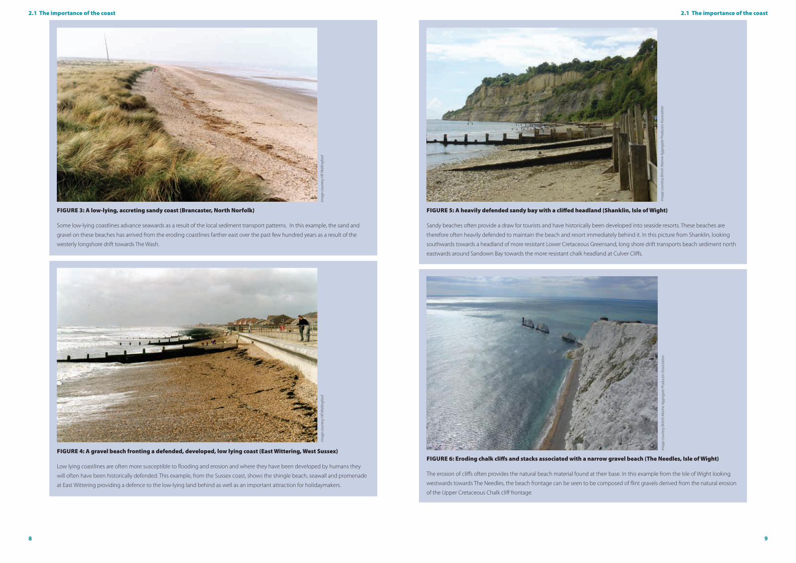
FIguRE 3: A low-lying, accreting sandy coast (Brancaster, North Norfolk)
Some low-lying coastlines advance seawards as a result of the local sediment transport patterns. In this example, the sand and
gravel on these beaches has arrived from the eroding coastlines farther east over the past few hundred years as a result of the
westerly longshore drift towards The Wash.
FIguRE 5: A heavily defended sandy bay with a cliffed headland (Shanklin, Isle of Wight)
Sandy beaches often provide a draw for tourists and have historically been developed into seaside resorts. These beaches are
therefore often heavily defended to maintain the beach and resort immediately behind it. In this picture from Shanklin, looking
southwards towards a headland of more resistant Lower Cretaceous Greensand, long shore drift transports beach sediment north
eastwards around Sandown Bay towards the more resistant chalk headland at Culver Cliffs.
FIguRE 4: A gravel beach fronting a defended, developed, low lying coast (East Wittering, West Sussex)
Low lying coastlines are often more susceptible to flooding and erosion and where they have been developed by humans they
will often have been historically defended. This example, from the Sussex coast, shows the shingle beach, seawall and promenade
at East Wittering providing a defence to the low-lying land behind as well as an important attraction for holidaymakers.
FIguRE 6: Eroding chalk cliffs and stacks associated with a narrow gravel beach (The Needles, Isle of Wight)
The erosion of cliffs often provides the natural beach material found at their base. In this example from the Isle of Wight looking
westwards towards The Needles, the beach frontage can be seen to be composed of flint gravels derived from the natural erosion
of the Upper Cretaceous Chalk cliff frontage.
imag
e co
urte
sy H
R W
allin
gfor
d
imag
e co
urte
sy B
ritish
Mar
ine
Aggr
egat
e Pr
oduc
ers A
ssoc
iatio
nim
age
cour
tesy
Brit
ish M
arin
e Ag
greg
ate
Prod
ucer
s Ass
ocia
tion
imag
e co
urte
sy H
R W
allin
gfor
d

10 11
2.1 The importance of the coast 2.1 The importance of the coast
FIguRE 7: A defended and developed spit (Mudeford, Dorset)
Many of our vulnerable coastlines are now heavily defended. Taken from Hengistbury Head looking north east towards
Christchurch Bay, this figure shows the effects of the strong longshore drift evidenced by the accumulation of shingle against the
groynes. Much of the sand here has arrived from the beaches to the west in Poole Bay that have themselves been extensively
recharged from marine aggregate dredging areas on both sides of the Isle of Wight.
FIguRE 9: A low lying coastal plain fringed by saltmarsh and grazing marsh, with extensive mudflats and sand flats extending across the inter-tidal area (upper Severn Estuary)
The Severn Estuary has the second highest tidal range in the world at more than 12 metres, and the resulting environment is
highly dynamic reflecting the extreme physical conditions of strong flows, mobile sediments, changing salinity, high turbidity and
heavy scouring. The low lying plains in the upper estuary are highly dependent upon the saltmarshes and mudflats, which act as
natural soft sea defences, dissipating wave energy.
FIguRE 8: A defended developed bay and recharged beach (Minehead, Somerset)
Many of the beaches used recreationally around our coastline are maintained through replenishment (increasing beach levels
that have been depleted through natural coastal processes through the introduction of relict sediments from offshore sources). In
this photograph, taken soon after a major recharge scheme, the sandy beaches and stepped seawall that protect the seafront at
Minehead from flooding can be seen. The rock groyne in the foreground was installed to help retain the imported sand and hence
extend the life of the defences.
FIguRE 10: A coastal sand dune system (Talacre, North Wales)
This coastal sand dune system at Talacre forms the backdrop to the beach at Point of Ayr, in Flintshire, North Wales. It represents
a highly dynamic system, dependent upon a supply of dry sand and onshore winds with pioneer plant species such as Marram
Grass (Ammophilaarenaria) providing stability as they take root. A process of sand dune succession sees the youngest dune
features located nearest the coast, with the dunes increasing in age as they progress further inland. Such systems play an
important role in providing natural coastal defences, however they are dependent upon the coast’s capacity to erode naturally
which in turn releases sediment to replenish the sand dunes as they evolve.
imag
e co
urte
sy H
R W
allin
gfor
d
imag
e co
urte
sy A
ndre
w Lu
cas,
Nat
ural
Res
ourc
es W
ales
imag
e co
urte
sy H
R W
allin
gfor
d
imag
e co
urte
sy R
od Jo
nes,
Nat
ural
Res
ourc
es W
ales

12 13
2.2 Characteristics and origins of our coastline2.2 Characteristics and origins of our coastline
FIguRE 11: Characteristics of the coastline and the main sources of marine aggregate around England and Wales. The offshore
sands and gravels are derived from a range of geological sources depending on the dredging location. Glacial deposits are
dredged in Liverpool Bay and off the Humber, ancient submerged river deposits are dredged off East Anglia and the South Coast,
and more recent marine deposits are dredged in the Bristol Channel.
2.2 Characteristics and origins of our coastline
Our coastline consists of a naturally diverse mix of cliffs, bays, headlands and estuaries, reflecting the varying underlying geology
and the effects of waves, tides and rivers over thousands of years. As marine aggregate dredging occurs offshore from the
coastlines of Yorkshire round to Dorset, in the Bristol Channel and in the Irish Sea, this chapter will concentrate on these coasts.
The underlying geology around the coast comprises harder rocks eg chalk and limestone, which forms high cliffs that are more
resistant to marine erosion, as well as softer, more erodible rocks eg consolidated Tertiary sands and muds which form low-lying
coastlines (Figure 11). Inshore of some existing marine aggregate dredging areas, the underlying solid geology is not exposed
and more recently deposited Quaternary sediments (covering the changing environments of the last 2 million years) form the
coastline. These range from glacial sediments deposited by ice, eg glacial tills around the Humber, to mud, sands and gravels
deposited by rivers and the sea elsewhere. These unconsolidated sediments are invariably weaker than the bedrock and form low-
lying coastlines.
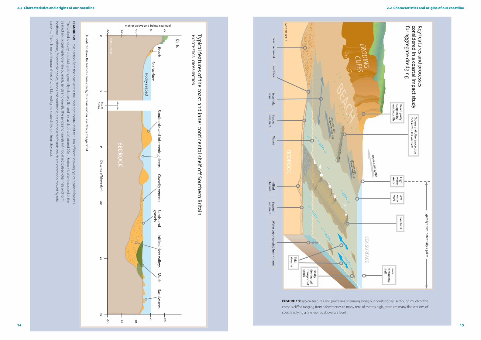
Beaches are confined to the coastal margin and often overlie more extensive seaward dipping rock platforms. In places farther
offshore, the rock platforms are overlain by sheets and banks formed of sands or gravels (Figure 12).
The current position of the coastline of England and Wales is the result of evolution over the past few million years as sea levels,
erosion and deposition of gravel, sands and muds have fluctuated in response to the varying climate. In particular, the coastline
we see today is a result of the marine transgression at the end of the last Ice Age; this has taken place over the past 10,000 years,
with sea levels reaching their existing levels only about 4,000 years ago. Natural change of the shoreline, whether it is eroding
or accreting, still continues (Figure 13). These changes may result in locally enhanced or reduced erosion rates, creating or
maintaining important habitats and potentially resulting in problems for local communities where they have settled in areas
undergoing change. Historic reclamation of land (for example in East Anglia), ongoing sea level rises and coastal defence schemes
also contribute to the process of coastal change which may enhance or degrade natural habitats. Modern-day marine processes
acting on the coastline and adjacent seabed arise from the interaction of waves, tides and wind and their associated flows. Surges,
rainfall and freshwater run-off also contribute to coastal dynamics. Whilst the relative importance of each of these components to
the coast may have changed through time, the processes themselves have remained the same.
It is against this background that a CIS should assess any potential effects of proposed marine aggregate dredging. A clear
understanding of the geological origins and development of the coast, its associated processes and its present and likely future
evolution, is vital for a robust assessment of any potential impacts arising from proposed aggregate extraction.
14 15
2.2 Characteristics and origins of our coastline2.2 Characteristics and origins of our coastline
FIguRE 13: Typical features and processes occurring along our coasts today. Although much of the
coast is cliffed ranging from a few metres to many tens of metres high, there are many flat sections of
coastline, lying a few metres above sea level.
FIgu
RE 12: Cross section from
the coast across the inner continental shelf to 30km offshore show
ing typical seabed features.
The seabed is locally undulating but generally relatively flat and lies at depths of around 20m. Bedrock is often exposed at the
seabed and occasionally overlain by muds, sands and gravels. The sands and gravels infill localised palaeo-channels and form
bedforms. Bedform
s, for example ripples, dunes and sandbanks, are com
posed of sands which are com
monly m
oved by tidal
currents. There is no continuous sheet of sand blanketing the seabed offshore from the coast.

16 17
2.3 Marine aggregate extraction around the uK coastline
FIguRE 14: A marine aggregate dredger discharging a cargo of sand and gravel at a London wharf on the River Thames, in the
shadow of the Millennium Dome and Canary Wharf and a stone’s throw from the 2012 Olympic Park. Around 7 million tonnes of
marine sand and gravel are typically landed at wharves along the Thames every year.
FIguRE 15: Since 1999, over 16 million tonnes of marine sand and gravel has been used for beach replenishment projects such
as this example, taking place at Bournemouth, Dorset.
imag
e co
urte
sy o
f the
Brit
ish M
arin
e Ag
greg
ate
Prod
ucer
s Ass
ocia
tion
imag
e co
urte
sy W
estm
inst
er D
redg
ing
Co L
td
2.3 Marine aggregate extraction around the uK coastline
Marine aggregate supplies are important to the economy, particularly the construction industry, exports and coastal defences
(Highley et al, 2007). Over the past five decades, over 800 million tonnes of marine sand and gravel has been supplied for
construction use and 80 million tonnes for beach replenishment (Selby, 2011). The importance of the marine aggregate resource is
recognised in the UK Government’s Marine Policy Statement (MPS) published in 2011 and English Government’s National Planning
Policy Framework published in 2012. The MPS in particular notes that:
‘Marine sand and gravel make a crucial contribution to meeting the nation’s demand for construction aggregate materials . . . In addition
there are often no practicable alternative sources to marine aggregates for the maintenance of coastal defences required for climate
change adaptation. Marine aggregates contribute to energy security and economic development through provision of fill for major
coastal infrastructure projects, for example ports, renewable energy and nuclear energy projects. The extraction of marine dredged sand
and gravel should continue to the extent that this remains consistent with the principles of sustainable development, recognising that
marine aggregates are a finite resource and in line with the relevant guidance and legislation.’
Typically around 20-25 million tonnes of marine aggregates are dredged offshore from England and Wales each year, contributing
around 20 per cent of the sand and gravel used in construction each year. Locally, for example in the London region, marine
aggregates contribute 50 per cent of sand and gravel supplied for construction and have been used on many major projects, eg
QEII bridge, the Thames Barrier, the 2012 Olympic Park and the development of Canary Wharf (Figures 14 and 15).
Marine aggregates are dredged from the seabed, particularly off the Humber, East Anglia, central South Coast of England and
in the Bristol Channel, and are typically supplied to discharge wharves in markets close to the dredging licence. For example,
sand and gravel dredged from the Eastern English Channel will typically be delivered into London 18 hours after dredging. The
UK marine dredging industry has invested heavily in the supply of offshore aggregates, operating a fleet of dredgers with a
replacement cost >£1bn and a series of wharf and associated infrastructure developments. A glossary of terms associated with
marine aggregates dredging can be found at www.bmapa.org.
The process of licensing aggregate dredging can take many years, beginning when companies submit tenders to The Crown
Estate for the commercial right to explore the seabed for marine aggregates. If suitable aggregate resources are identified, the
company pursues an application for a regulatory consent to dredge an area, which involves undertaking an environmental impact
assessment of the proposed dredging (see section 3). If the impacts of a proposal are considered acceptable to the competent
authority (the Marine Management Organisation (MMO) in English waters and Natural Resources Wales (NRW) in Welsh waters,
who consult and are advised by government experts and other stakeholders), then a marine licence (regulatory consent) will
typically be issued for up to 15 years, with all consents being reviewed by the regulator at five-year intervals. Following issue of a
marine licence, a commercial production agreement to dredge aggregates will then be granted by The Crown Estate.
The Crown Estate and mineral rights
The Crown Estate (www.thecrownestate.co.uk) owns virtually the entire seabed out to the 12 nautical mile territorial limit as well as
having the rights to explore and utilise the natural resources of the UK continental shelf such as aggregates. As the landowner, The
Crown Estate issues commercial production agreements for marine aggregate dredging, although the marine licence to dredge
is given by the regulator – either the Marine Management Organisation in English waters (a Non-Departmental Public Body) or
Natural Resources Wales in Welsh waters (a Welsh Government Sponsored Body). In 2012/13, the turnover for The Crown’s Energy
and Infrastructure portfolio was £39.1 million, of which £15.3 million was derived from marine aggregate dredging. The Crown
Estate has two main objectives: to enhance the value of the estate and the income it generates; and to manage the estate in a
responsible manner. Royalties from mineral extraction benefit the taxpayer by contributing revenue from national assets directly to
the Treasury.
18 19
3 Regulatory context and environmental impact assessment
Assessment of the potential effects of the dredging activity (CLg, 2002)
A9. When evaluating the potential effects of the proposed dredging programme the ES should identify and quantify the
consequences of the proposal on the environment, fisheries and other uses of the sea. Ideally, this should be summarised as
an impact hypothesis, drawing on the results of earlier studies. The assessment of some of the potential impacts will require
predictive techniques, and it may be necessary to use appropriate mathematical models. Where such models are used there
should be sufficient explanation to enable an informed assessment of their suitability for the particular modelling exercise to be
undertaken.
Physical effects of dredging
A10. To assess the physical impact of aggregate extraction on the hydrographic and seabed environments, information should
be provided on:
� likely production of a sediment plume (from the draghead at the seabed, from hopper overflow, or on-board screening) and
its subsequent transportation within the water column or along the seabed. This should be considered together with the
background suspended load.
� implications for coastal erosion (through a Coastal Impact Study), in particular whether:
the proposed dredging is far enough offshore for there to be no beach drawdown into the deepened area;
the proposed dredging will interrupt the natural supply of materials to beaches through tides and currents;
the likely effect on bars and banks which provide protection to the coast by absorbing wave energy, and the potential
impact on local tidal patterns and currents which could lead to erosion;
likely changes to the height of waves passing over dredged areas and the potential effect on the refraction of waves
which could lead to significant changes in the wave pattern;
the likely effects on the seabed of removing material. In particular the nature of the sediment to be left once dredging
ceases, and the likely nature and scale of the resulting topography (eg ridges and furrows);
implications for local water circulation resulting from the removal or creation of topographical features on the seabed;
assessment of the impacts in relation to other active or proposed dredging operations in the area.
The CIS should accurately reflect any assumptions and inputs associated with the assessment of proposed marine aggregate
dredging, provide a detailed simulation of that dredging and be prepared to utilise a range of techniques including numerical
modelling to ensure possible changes in waves, currents and sediment transport are accurately assessed. In assessing the CIS
component of the final Environmental Statement, the competent authority will request formal advice on coastal issues from
its advisors, (eg. Cefas, Natural England, the Environment Agency, Natural Resources Wales and English Heritage), whilst other
stakeholders will also have the opportunity to comment through the public consultation process that is required. The applicant is
expected to have also consulted on the proposed CIS scope with relevant stakeholders prior to the commencement of the study.
A stand-alone CIS should be transparent and accessible to all interested parties (see section 10).
3 Regulatory context and environmental impact assessment
An annex within earlier English Government guidance on marine mineral extraction (Marine Mineral Guidance Note 1, CLG (2002))
defined the specific information and assessments required to review coastal erosion. Although MMG1 has now been superseded,
the principles it established continue to form the basic structure for modern impact assessments.
The Marine and Coastal Access Act 2009 (MCAA) came into force on the 6th April 2011 and provides the legislative framework for
applications to extract marine aggregates.
In both England and Wales, the Marine Works (Environmental Impact Assessment) Regulations (MWR) 2007 as amended by the
MWR 2011 apply the EIA requirements to activities requiring a marine licence under the MCAA.
These regulations are supported by policy presented in the UK Marine Policy Statement (HM Government, 2011) which provides
the framework for preparing Marine Plans and taking decisions affecting the marine environment and is intended to contribute to
the achievement of sustainable development in the UK marine area.
The Marine Policy Statement (MPS) states that marine plan authorities should as a minimum make provision within Marine Plans
for a level of supply of marine sand and gravel that ensures that marine aggregates contribute to the overarching Government
objective of securing an adequate and continuing supply to the UK market for various uses.
Marine plan authorities and decision makers should base decisions on sustainability criteria and should take into account:
� the existing seabed within the marine plan area that is currently being dredged;
� offshore movement of aggregates (i.e. supply between regions & exports);
� the importance of meeting regional and national needs, beach replenishment and contract fill; and
� the need to safeguard reserves for future extraction.
Where an Environmental Impact Assessment (EIA) is required for the proposed dredging operation and that EIA includes an
assessment of the physical effects of the operation and its implications for coastal erosion, then decision makers should consider
the need for a Coastal Impact Study (CIS).
The MPS concludes by stating that a marine licence or other regulatory approval to dredge should only be issued if the decision
maker is content that the proposed dredging is environmentally acceptable.
In Wales, the Interim Marine Aggregates Dredging Policy (IMADP) (Welsh Assembly Government, 2004) sets out the policy for the
extraction of sand from the Bristol Channel and Severn Estuary as part of an integrated strategy for the supply of fine aggregate
to South Wales. IMADP seeks to ensure sustainable, objective and transparent decision-making to meet society’s needs for
aggregates dredged from the Bristol Channel, Severn Estuary and River Severn by making provision to:
� Identify areas where dredging for marine aggregates is likely to be acceptable;
� Protect the marine and coastal environment – landscape, habitats, ecology and heritage;
� Control the impacts of marine dredging to acceptable levels;
� Encourage efficient and appropriate use of dredged aggregates;
� Safeguard resources from sterilisation; and
� Protect the interests of other users of the area.
In doing this, IMADP reinforces the need for coastal impacts to be fully considered through the Environmental Impact Assessment
process for new or renewed applications to dredge aggregates.
Although it may be undertaken as a discrete study, the CIS will normally form a key component of the EIA process and the final
Environmental Statement that results. In undertaking a CIS, it will always be necessary to establish a robust understanding of the
existing coastal and seabed environment, and this guidance note defines and advises on the best practice process and methods
required to deliver the assessments required.
3. Regulatory context and environmental impact assessment in England and Wales
20 21
4.2 general methodology for a Coastal Impact Study
4.1 Introduction
The scope, methods and extent of a suitable Coastal Impact Study for any proposed marine aggregate dredging will depend upon
the details of that particular application.
For example, a proposal to dredge in an isolated area that is very distant from the coastline, and where the water depths are
greater than 40m deep, is likely to require less detailed investigation of potential effects on wave propagation than for a proposed
area lying in water depths of less than 20m that is close to numerous other dredging areas or licence proposals. Similarly, a
proposal to dredge immobile, coarse-grained sediments from an area well offshore will require less consideration of the possible
impacts on sediment supply to a coastline than a proposal to extract mobile and fine-grained sand from a nearshore sandbank.
Consideration will also need to be given to the potential for the proposed extraction to interact with nearby marine protected
areas, such as offshore sandbanks.
The sensitivity of an application will be estimated from at least:
� The initial scoping exercise and the physical characteristics at the site;
� Any Marine Aggregate Regional Environmental Assessment (a voluntary, non-statutory assessment undertaken by industry
to address cumulative and in-combination impacts arising from regional aggregate extraction feeding in to site specific EIA
requirements) for the relevant area;
� Coastal Impact Studies for previous dredging in the proposed extraction area, or for other nearby areas;
� The presence of any sensitive receptor (eg a sandbank) in the region.
Applicants are advised to refer to all potential sources of relevant information before undertaking their CIS. Guidance on typical
data requirements and sources for that information are provided in the appendix to this report.
4.1.1 Definition of the coastal zone and limits of the CIS
The coastal zone is the meeting place of land, air and seawater. A CIS will review the effect of the marine aggregate dredging
proposal on this zone as a whole. For the purpose of a CIS:
The landward extent of the coast is assumed to be the limit of the area affected by the sea, which lies above the high water and
back to cliffs, beaches, wetlands or landward limit of the sea’s influence and includes all sea defences;
Offshore, the seaward limit lying below low water is more complex as the CIS will assess potential changes to the nearshore
zones and offshore banks if changes to these could impact the landward extent of the coast.
A CIS will assess potential effects on the visible coast and therefore includes bays and headlands, beaches, rock platforms, cliffs, etc,
together with underwater features on the nearshore seabed and offshore banks and bars. Where appropriate, these extents may
continue to the limits of the relevant coastal sediment cells, as referred to in the Shoreline Management Plan(s) for the area.
Note that the coastal zone transgresses various land-based and marine policies, planning, development and protection regimes
and authorities. Consequently, the CIS should accommodate and recognise the various interests in the coastal zone.
4. Coastal Impact Studies: overall approach
European and international benchmarking
Assessment of potential coastal impacts associated with marine aggregate dredging in UK waters is rigorous and of a high
standard. In Europe, aggregate dredging occurs mainly in the UK, Netherlands, Belgium, Denmark and France (ICES, 2012). Around
60 million tonnes of sand is typically dredged annually from the Dutch continental shelf for the purposes of beach nourishment
and fill, with larger volumes extracted to support major infrastructure projects eg Maasvlakte 2 (extension of Rotterdam harbour)
where over 240 million m3 of sand has been used. In the Netherlands, no CIS is required if the dredging lies seaward of the 20m
isobath and will remove <2m of sediment from below the seabed. No formal CIS has been undertaken for the Belgian dredging
licences, although a comprehensive bathymetric monitoring programme is carried out. In Denmark, dredging licences are subject
to individual environmental assessment supported by a CIS, with dredging not being consented in water depths less than 6m.
A formal CIS is not required for permission to dredge in France. Elsewhere, for example in the USA and Australia, permissions are
locally determined and often do not require a comprehensive CIS.
Learning the lessons - dredging the beach at Hallsands, Devon
There has been only one occasion of coastal impact associated with aggregate dredging in England (Melia, 2002). In the late
nineteenth century, the Admiralty decided to double the size of the docks at Devonport, Plymouth, which required large volumes
of concrete. In 1896, the company requested permission to extract shingle from along the coast, saying “The quantity required
cannot be accurately stated but in no case will it be sufficient as to in any way interfere with the cliffs or adjoining land . . .”
In April 1897, without any consultation with the villagers, dredging of shingle began off Hallsands between high and low water
marks, removing the beach in front of the seawall, road, houses and cliffs. Despite opposition from local people, the dredging
continued and 660,000 tonnes were removed over a three-year period. A local inquiry was held to hear concerns, and dredging
moved along the coast slightly to the north of the village, but nevertheless the authorities assumed that the shingle would be
replenished by the sea.
By 1900, the level of the beach began to fall. High tides came increasingly close to the houses at the base of the cliff, resulting in
more frequent wave attack against the seawall and building foundations. With the beach continuing to fall in height, the Board
of Trade revoked the licence in 1902 and dredging ceased. Finally, a severe storm in January 1917 destroyed Hallsands village and
forced the complete evacuation of the site.
The Hallsands disaster illustrates that removing beach sediment between high and low water reduces the height of the beach and
exposes the coast inland to the full force of the sea, especially during storms. The beach level at Hallsands reduced by 4m due to
drawdown as a direct consequence of the removal of the shingle and the accelerated erosion resulted in the loss of the village.
The beach dredging at Hallsands would not have been permitted had the dredging application been subject to a CIS and the
standards of regulatory control and environmental protection in force today.
3 Regulatory context and environmental impact assessment
22 23
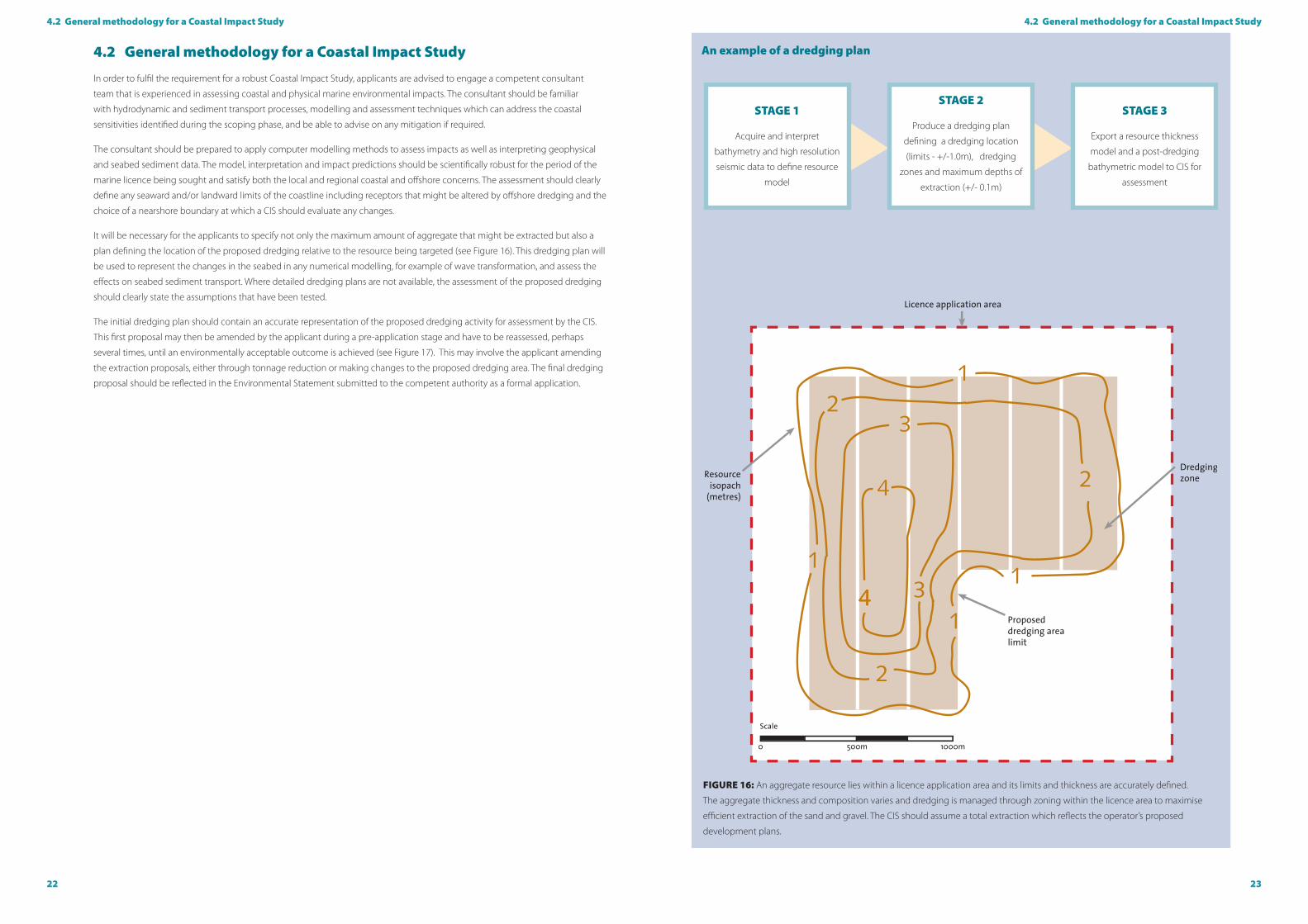
An example of a dredging plan
FIguRE 16: An aggregate resource lies within a licence application area and its limits and thickness are accurately defined.
The aggregate thickness and composition varies and dredging is managed through zoning within the licence area to maximise
efficient extraction of the sand and gravel. The CIS should assume a total extraction which reflects the operator’s proposed
development plans.
STAgE 1
Acquire and interpret
bathymetry and high resolution
seismic data to define resource
model
STAgE 2
Produce a dredging plan
defining a dredging location
(limits - +/-1.0m), dredging
zones and maximum depths of
extraction (+/- 0.1m)
STAgE 3
Export a resource thickness
model and a post-dredging
bathymetric model to CIS for
assessment
4.2 general methodology for a Coastal Impact Study4.2 general methodology for a Coastal Impact Study
4.2 general methodology for a Coastal Impact Study
In order to fulfil the requirement for a robust Coastal Impact Study, applicants are advised to engage a competent consultant
team that is experienced in assessing coastal and physical marine environmental impacts. The consultant should be familiar
with hydrodynamic and sediment transport processes, modelling and assessment techniques which can address the coastal
sensitivities identified during the scoping phase, and be able to advise on any mitigation if required.
The consultant should be prepared to apply computer modelling methods to assess impacts as well as interpreting geophysical
and seabed sediment data. The model, interpretation and impact predictions should be scientifically robust for the period of the
marine licence being sought and satisfy both the local and regional coastal and offshore concerns. The assessment should clearly
define any seaward and/or landward limits of the coastline including receptors that might be altered by offshore dredging and the
choice of a nearshore boundary at which a CIS should evaluate any changes.
It will be necessary for the applicants to specify not only the maximum amount of aggregate that might be extracted but also a
plan defining the location of the proposed dredging relative to the resource being targeted (see Figure 16). This dredging plan will
be used to represent the changes in the seabed in any numerical modelling, for example of wave transformation, and assess the
effects on seabed sediment transport. Where detailed dredging plans are not available, the assessment of the proposed dredging
should clearly state the assumptions that have been tested.
The initial dredging plan should contain an accurate representation of the proposed dredging activity for assessment by the CIS.
This first proposal may then be amended by the applicant during a pre-application stage and have to be reassessed, perhaps
several times, until an environmentally acceptable outcome is achieved (see Figure 17). This may involve the applicant amending
the extraction proposals, either through tonnage reduction or making changes to the proposed dredging area. The final dredging
proposal should be reflected in the Environmental Statement submitted to the competent authority as a formal application.

24 25
4.3 guiding principles4.2 general methodology for a Coastal Impact Study
4.3 guiding principles
As discussed in section 2, for the purposes of the CIS, the coast is assumed to be static and stable to enable the analysis of any
potential additional impacts arising from aggregate extraction. The analysis of significance of effects and sensitivity of the coastal
receptors will need to be addressed through the wider EIA process.
To reflect the value of the coastline and best practice in assessment, there are a number of important principles which must be
borne in mind when undertaking a CIS. The study should be:
� Scientifically robust, using validated techniques and models;
� Transparent and auditable.
Firstly, to be consistent with coastal defence practices (for example reducing flood risks in line with Policy Planning Statement 25
in England (CLG, 2010) or Technical Advice Note 15: Development and Flood Risk in Wales (WAG, 2004)), the CIS standards adopted
for marine aggregate dredging assessment should be comparable to the standards adopted for studies of coastal defence design
(for example ICE Design and Practice Guides: Coastal Defence (ICE, 2002)) and make allowances for climate change. This will
therefore take into account exceptionally severe wave conditions/tidal levels, considering the combination of these on which the
effects of dredging would be greatest. Also, allowance should be made for changes in tidal levels relative to the land, and in waves,
that might be brought about by global warming and associated climate change for the duration of the dredging application.
Climate change assumptions should be adopted from the latest UKCIP (or MCCIP) data.
The CIS should avoid judging whether predicted changes in the hydrodynamic or sediment transport regime of coastlines are
adverse or favourable. Similarly, no judgements should be made about whether a section of a coastline is more or less resilient to
any predicted changes. Rather, the acceptability of any predicted changes in the hydrodynamic and sedimentological regimes/
environment of the coast, or the nearshore seabed, will need to be assessed for each particular situation (see section 8.2). The
findings of the CIS should be used to inform the wider environmental impact assessment process, where the significance and
potential risks of any predicted changes will be considered.
A CIS should be scientifically robust, applying validated techniques and models and using the latest data and understanding (see
Figure 18). In support there is an extensive body of previous CIS reports for marine aggregate dredging applications available.
These studies provide a robust information baseline, having used a number of established techniques for assessing the effects on
coastlines of marine aggregate dredging.
Details on the applicability and validation (including site specific calibration and validation) of any numerical modelling methods
should be provided, together with relevant references to scientific literature. Similarly, the modelling input data should be
presented and justified, again with references to the sources of technical or scientific information. It is likely that in many instances,
a CIS will make extensive use of the data from regional marine aggregate studies, for example Marine Aggregate Regional
Environmental Assessments and Regional Environmental Characterisation surveys. There is often a considerable amount of good
quality information available, for example in the form of detailed seabed surveys collected with multi-beam echo-sounding
and side-scan sonar, that will provide both baseline information for a CIS for proposed marine aggregate dredging and that will
demonstrate the effects of past aggregate dredging in similar areas.
Finally, it is important that the results obtained in any CIS can be tested by the regulator, another consultant or the public if
necessary. For this to be possible, the input data, methods used and any constraints should be described in detail and made
available. Although some of the data and the models will be subject to copyright, wherever possible enough detail should
be provided to allow these to be obtained and used by a third party. In this way, all stages of the CIS would be transparent to
interested parties, and the way that results have been obtained and interpreted laid out in a fashion that can be followed and
audited.
FIguRE 17. The consultation process for a Coastal Impact Study
CIS Consultation Process
Dredging Application Area
Dredging Plan before dredge
proposal eg. zones, dredging
depths, etc
Model and assess impacts on
coast and seabed
Informal review by
EA/Cefas/NRW/NE
Informally consult with
stakeholders if required
Submit final CIS as part of
ES
Non-technical summary Technical document with
appendices
acceptable
acceptable
acceptable
unacceptable
unacceptable
unacceptable
Option
to modify
dredging plans
26 27
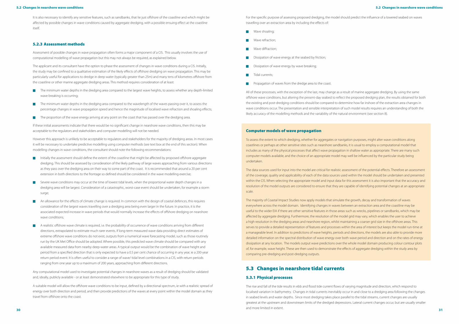
4.4 Assessment criteria4.4 Assessment criteria
FIguRE 19: Dredging may be permitted, for example, if waves are not significantly changed at the coastline, tidal
current flow remains the same, seabed sediment is moving parallel to the coast, and there is no connection between the
dredged deposits offshore and the beaches.
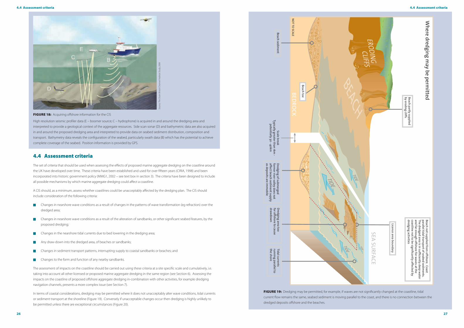
FIguRE 18: Acquiring offshore information for the CIS
High resolution seismic profiler data (E – boomer source; C – hydrophone) is acquired in and around the dredging area and
interpreted to provide a geological context of the aggregate resources. Side scan sonar (D) and bathymetric data are also acquired
in and around the proposed dredging area and interpreted to provide data on seabed sediment distribution, composition and
transport. Bathymetry data reveals the configuration of the seabed, particularly swath data (B) which has the potential to achieve
complete coverage of the seabed. Position information is provided by GPS.
Sour
ce; T
he O
uter
Bris
tol C
hann
el H
abita
t Stu
dy, 2
006
4.4 Assessment criteria
The set of criteria that should be used when assessing the effects of proposed marine aggregate dredging on the coastline around
the UK have developed over time. These criteria have been established and used for over fifteen years (CIRIA, 1998) and been
incorporated into historic government policy (MMG1, 2002 – see text box in section 3). The criteria have been designed to include
all possible mechanisms by which marine aggregate dredging could affect a coastline.
A CIS should, as a minimum, assess whether coastlines could be unacceptably affected by the dredging plan. The CIS should
include consideration of the following criteria:
� Changes in nearshore wave conditions as a result of changes in the patterns of wave transformation (eg refraction) over the
dredged area;
� Changes in nearshore wave conditions as a result of the alteration of sandbanks, or other significant seabed features, by the
proposed dredging;
� Changes in the nearshore tidal currents due to bed lowering in the dredging area;
� Any draw-down into the dredged area, of beaches or sandbanks;
� Changes in sediment transport patterns, interrupting supply to coastal sandbanks or beaches; and
� Changes to the form and function of any nearby sandbanks.
The assessment of impacts on the coastline should be carried out using these criteria at a site specific scale and cumulatively, i.e.
taking into account all other licensed or proposed marine aggregate dredging in the same region (see Section 6). Assessing the
impacts on the coastline of proposed offshore aggregate dredging in-combination with other activities, for example dredging
navigation channels, presents a more complex issue (see Section 7).
In terms of coastal considerations, dredging may be permitted where it does not unacceptably alter wave conditions, tidal currents
or sediment transport at the shoreline (Figure 19). Conversely if unacceptable changes occur then dredging is highly unlikely to
be permitted unless there are exceptional circumstances (Figure 20).

28 29
4.4 Assessment criteria
5.1 Introduction
This section details a recommended methodology for assessing the potential impact on the coastline of proposed marine
aggregate dredging building upon established best practice. The approach is based on evaluation of the six assessment criteria
introduced in section 4.4 (Figures 19 and 20). Note that the two criteria relating to changes in wave conditions are discussed
together in section 5.2, while changes to sandbank form and function are considered under sections 5.4 and 5.5. Receptors and
sensitivities will vary on a site specific basis and will need to be considered through the wider Environmental Impact Assessment
process.
5.2 Changes in nearshore wave conditions
5.2.1 Physical processes Wave action results in erosion, deposition and sediment transport at the coastline and the wave climate of a region is defined by
the temporal distribution of wave height, period and direction. The lowering of the sea floor by marine aggregate dredging will
alter the way that waves travel over that part of the seabed. Changes in waves will often be small, except in the immediate vicinity
of the dredging area, especially when extraction takes place in deep water areas. However, there is a need to ensure that any
changes in wave conditions as far away as the coastline are not unacceptably large.
The wave propagation mechanisms that may be altered by dredging the seabed can be divided into two classes:
1. Energy-conserving processes – changes in water depth over a dredged area will alter the local speed of wave propagation,
resulting in an alteration in wave direction by the process of refraction. There will also be an associated change in wave heights, a
process known as shoaling, although this will be restricted to the dredged area. These changes do not alter the amount of wave
energy passing over the dredged area, although they will alter the wave direction across that area, and possibly extending to
the coast. During and after their passage over the dredged area, the localised changes in wave height and direction will lead to
diffraction, a process by which the effects of the dredging on wave propagation will be reduced.
2. Energy-dissipating processes – there may be some dissipation of wave energy as it travels over shallow waters (less than 10m
deep) in or close to a dredging area. Altering the seabed by dredging can alter the amount of energy dissipation that occurs as
waves pass over the extraction area. The most obvious example of this would be where proposed dredging would remove or
lower a mound or bank of sediment. If this feature causes wave breaking, because of the shallow water depths over its crest, then
lowering it will increase wave heights landward of the dredging area; this effect could hypothetically extend as far as the coastline.
5.2.2 Information required
Consideration of the effects of dredging on wave propagation requires information on the wave climate, on the existing
bathymetry and the proposed dredging plan (see section 4.2). In addition, predictions will need to be made of the most severe
wave conditions that are likely to occur, from a range of different wave directions, as described in section 5.2.3.
Modelling is commonly needed to assess the effects of proposed dredging on waves, either for a single area or cumulatively
with other licensed or proposed dredging areas, and bathymetric data is required between the dredging area and the coastline.
This bathymetry will need to be adjusted to represent seabed levels “before” and “after” the planned dredging in the proposed
extraction area as a minimum. Where an application is made for an extension of an existing licence, or the application needs to be
considered cumulatively with other existing or proposed marine aggregate dredging (see section 6), the representation of seabed
levels will need to take this other activity into account. In preparing these representations for licence areas where dredging has
already occurred, the applicant can usefully draw upon historic Electronic Monitoring System (EMS) records to accurately define
where historic extraction activity has occurred.
5. Assessment methods: technical review
FIguRE 20: Dredging may not be permitted, for example, if waves are significantly changed at the coast leading to erosion or
deposition, or dredging adversely changes the tidal currents transporting seabed or beach sediments, or the dredging interrupts
sediment supply to beaches.
30 31
5.2 Changes in nearshore wave conditions5.2 Changes in nearshore wave conditions
For the specific purpose of assessing proposed dredging, the model should predict the influence of a lowered seabed on waves
travelling over an extraction area by including the effects of:
� Wave shoaling;
� Wave refraction;
� Wave diffraction;
� Dissipation of wave energy at the seabed by friction;
� Dissipation of wave energy by wave breaking;
� Tidal currents;
� Propagation of waves from the dredge area to the coast.
All of these processes, with the exception of the last, may change as a result of marine aggregate dredging. By using the same
offshore wave conditions, but altering the present-day seabed to reflect the proposed dredging plan, the results obtained for both
the existing and post-dredging conditions should be compared to determine how far inshore of the extraction area changes in
wave conditions occur. The presentation and sensible interpretation of such model results requires an understanding of both the
likely accuracy of the modelling methods and the variability of the natural environment (see section 8).
Computer models of wave propagation
To assess the extent to which dredging, whether for aggregates or navigation purposes, might alter wave conditions along
coastlines or perhaps at other sensitive sites such as nearshore sandbanks, it is usual to employ a computational model that
includes as many of the physical processes that affect wave propagation in shallow water as appropriate. There are many such
computer models available, and the choice of an appropriate model may well be influenced by the particular study being
undertaken.
The data sources used for input into the model are critical for realistic assessment of the potential effects. Therefore an assessment
of the coverage, quality and applicability of each of the data sources used within the model should be undertaken and presented
within the CIS. When selecting the appropriate model and input data for this assessment it is also important that the accuracy and
resolution of the model outputs are considered to ensure that they are capable of identifying potential changes at an appropriate
scale.
The majority of Coastal Impact Studies now apply models that simulate the growth, decay and transformation of waves
everywhere across the model domain. Identifying changes in waves between an extraction area and the coastline may be
useful to the wider EIA if there are other sensitive features in those areas such as wrecks, pipelines or sandbanks, which may be
affected by aggregate dredging. Furthermore, the resolution of the model grid may vary, which enables the user to achieve
a high resolution in the dredging areas and nearshore region, whilst maintaining a coarser grid size in the offshore areas. This
serves to provide a detailed representation of features and processes within the area of interest but keeps the model run-time at
a manageable level. In addition to predictions of wave heights, periods and directions, the models are also able to provide more
detailed information on the spectral distribution of wave energy over both wave period and direction and on the rates of energy
dissipation at any location. The models output wave predictions over the whole model domain producing colour contour plots
of, for example, wave height. These are then used to demonstrate the effects of aggregate dredging within the study area by
comparing pre-dredging and post-dredging outputs.
5.3 Changes in nearshore tidal currents
5.3.1 Physical processes
The rise and fall of the tide results in ebb and flood tide current flows of varying magnitude and direction, which respond to
localised variation in bathymetry. Changes in tidal currents inevitably occur in and close to a dredging area following the changes
in seabed levels and water depths. Since most dredging takes place parallel to the tidal streams, current changes are usually
greatest at the upstream and downstream limits of the dredged depressions. Lateral current changes occur, but are usually smaller
and more limited in extent.
It is also necessary to identify any sensitive features, such as sandbanks, that lie just offshore of the coastline and which might be
affected by possible changes in wave conditions caused by aggregate dredging, with a possible ensuing effect at the coastline
itself.
5.2.3 Assessment methods
Assessment of possible changes in wave propagation often forms a major component of a CIS. This usually involves the use of
computational modelling of wave propagation but this may not always be required, as explained below.
The applicant and its consultant have the option to phase the assessment of changes in wave conditions during a CIS. Initially,
the study may be confined to a qualitative estimation of the likely effects of offshore dredging on wave propagation. This may be
particularly useful for applications to dredge in deep water (typically greater than 25m) and many tens of kilometres offshore from
the coastline or other marine aggregate dredging areas. This method requires consideration of at least:
� The minimum water depths in the dredging area compared to the largest wave heights, to assess whether any depth-limited
wave breaking is occurring;
� The minimum water depths in the dredging area compared to the wavelength of the waves passing over it, to assess the
percentage changes in wave propagation speed and hence the magnitude of localised wave refraction and shoaling effects;
� The proportion of the wave energy arriving at any point on the coast that has passed over the dredging area.
If these initial assessments indicate that there would be no significant change in nearshore wave conditions, then this may be
acceptable to the regulators and stakeholders and computer modelling will not be needed.
However this approach is unlikely to be acceptable to regulators and stakeholders for the majority of dredging areas. In most cases
it will be necessary to undertake predictive modelling using computer methods (see text box at the end of this section). When
modelling changes in wave conditions, the consultant should note the following recommendations:
� Initially the assessment should define the extent of the coastline that might be affected by proposed offshore aggregate
dredging. This should be assessed by consideration of the likely pathway of large waves approaching from various directions
as they pass over the dredging area on their way to some part of the coast. It is recommended that around a 20 per cent
extension in both directions to the frontage so defined should be considered in the wave modelling exercise;
� Severe wave conditions may occur at the time of lowest tidal levels, when the proportional water depth changes in a
dredging area will be largest. Consideration of a catastrophic, worst-case event should be undertaken, for example a storm
surge;
� An allowance for the effects of climate change is required. In common with the design of coastal defences, this requires
consideration of the largest waves travelling over a dredging area being even larger in the future. In practice, it is the
associated expected increase in wave periods that would normally increase the effects of offshore dredging on nearshore
wave conditions;
� A realistic offshore wave climate is required, i.e. the probability of occurrence of wave conditions arriving from different
directions, extrapolated to estimate much rarer events. If long-term measured wave data providing direct estimates of
extreme offshore wave conditions do not exist, outputs from a numerical wave forecasting model, such as those routinely
run by the UK Met Office should be adopted. Where possible, this predicted wave climate should be compared with any
available measured data from nearby deep-water areas. A typical output would be the combination of wave height and
period from a specified direction that is only expected to have a 0.5 per cent chance of occurring in any year, ie a 200-year
return period event. It is often useful to consider a range of wave/ tidal level combinations in a CIS, with return periods
ranging from one year up to a maximum of 200 years, approaching from different directions.
Any computational model used to investigate potential changes in nearshore waves as a result of dredging should be validated
and, ideally, publicly available - or at least demonstrated elsewhere to be appropriate for this type of study.
A suitable model will allow the offshore wave conditions to be input, defined by a directional spectrum, ie with a realistic spread of
energy over both direction and period, and then provide predictions of the waves at every point within the model domain as they
travel from offshore onto the coast.
32 33
5.4 Beach and sandbank draw-down5.3 Changes in nearshore tidal currents
Nonetheless, the CIS should consider beach draw-down, and provide appropriate evidence to support any conclusions about the
potential risk.
Similarly where a proposed dredging area lies close to, or on, a sandbank feature which dissipates wave energy and provides some
shelter to the coastline, there is a possibility that dredging may lead to bank draw-down. Reduction of the bank crest through
dredging or slumping may in turn reduce the shelter to the coastline. Marine aggregate dredging will only be permitted if there is
clear evidence that beach and/or bank draw-down will not result, and the CIS should investigate whether this might occur.
5.4.2 Information required
Assessment of the risk of beach draw-down is based on understanding beach morphology change and its relationship to
sediment transport over the offshore seabed. For dredging to be acceptable, the analysis should review bathymetry, wave, tidal,
current and seabed sediment data (for example sediment samples and bedform mapping) to show that the beach sand may not
be eroded to infill offshore dredging areas or be locally re-deposited as a result of a changing hydrodynamic regime. Modelling
is not normally required, but the assessment of beach draw-down is commonly closely linked with the assessment of beach
sediment supply and transport.
5.4.3 Assessment methods
In most places around the coastline of England, beaches slope down to meet a near-horizontal shore-platform in water depths of
less than five to ten metres. The offshore interface between the beach sediments and the shore platform is known as the toe of
the beach. These platforms have been formed by erosion of the underlying substrate by successive sea level rises. The platforms
are composed of either consolidated Quaternary sediments or bedrock and typically have thin (generally <1m thick) veneers or
patches of overlying sands which may be moving across the seabed. Marine aggregate dredging permissions typically lie farther
offshore in depths greater than 15 metres.
Water depths at the underwater toe of the beaches along the coastline closest to the proposed dredging area should be identified
as closely as possible and the configuration and composition of the seabed between the beach and dredging area examined.
Marine aggregate dredging will only be permitted if it is well offshore from and in substantially deeper water than the toe of the
beaches with clear evidence that there is no significant sand transport between the beach and the dredging area.
Where dredging is proposed close to a significant sandbank, it is necessary to predict the effects of the proposed dredging on the
morphology of that bank, and this can be difficult not least because it is likely to be altering naturally as a result of changes in tidal
levels, currents and wave conditions. Monitoring of a number of aggregate extraction areas on or close to sandbanks over the last
ten years has shown that the crest levels of the banks have not been adversely affected by the dredging of sand even when this
extraction has taken place close to a mobile sandbank (see Case study: monitoring of dredging adjacent to a sandbank, page 46).
However, this cannot be taken for granted.
In practice, for dredging applications in such situations, it will be necessary to consider a range of possible changes in the
morphology of sandbanks in response to the planned extraction. The possible responses can range from assuming the proposed
dredging results in a depression that does not infill, to assuming that the amount of sand removed will result in a proportional
overall reduction in the height of the sandbank above the surrounding seabed. The effects of each of these possible alterations to
the sandbank on waves and tidal currents close to the coast will then need to be assessed (see sections 4.2 and 4.3).
There is a need to ensure that any changes in tidal currents as far away as the coastline are not unacceptably large. However it
is rare for aggregate dredging proposals to change tidal currents close to the coastline. Modelling of tidal flows is usually only
necessary when there are concerns within the wider EIA regarding impacts close to an extraction area, for example when a
pipeline or cable lies close by.
5.3.2 Information required
Consideration of the effects of dredging on tidal currents requires information on the dredging plan, the existing bathymetry and
modified bathymetry and tidal current velocities in the area.
If modelling is required to assess the effects of proposed dredging on tidal currents, for example when the proposed dredging
area is in shallow water and close to the coast, a greater amount of information will be needed and the model should be calibrated
and validated against measured data, ideally gathered close to the dredging area. Modelling of tidal currents requires knowledge
of the seabed bathymetry, stretching from seaward of the extraction area to the coastline. In addition a model of tidal currents will
normally require information on the changes in tidal level and current speeds around the edges of the model grid. The boundaries
of this grid will generally extend farther offshore and cover a greater length of coastline than used when investigating the possible
changes in nearshore wave conditions. As examples, in past Coastal Impact Studies, the areas considered in tidal flow models
have included (a) the Irish Sea north of Anglesey, (b) the whole of the Bristol Channel and Severn Estuary, (c) the English Channel,
and (d) the southern North Sea south of Flamborough Head, with the latter two models extending both sides of the Straits of
Dover.
5.3.3 Assessment methods
Assessment of changes to tidal currents should consider the results of previous modelling studies in the region, which may
indicate whether the dredging area will significantly affect tidal flows along the coast (CIRIA, 1998). It is also necessary to review
and locate any sensitive features, such as sandbanks, lying offshore of the coastline that might be affected by possible changes in
tidal currents.
Exceptionally in situations where the sediment to be dredged is very mobile, and possible impacts on the supply of sediment to a
coastline need to be investigated (see section 5.5), it may be necessary to set up numerical models of tidal flows that extend from
well seawards of the dredging area and up to the coastline. In cases where another dredging area may be located down-drift of
the site being studied, an assessment of the implications of extraction to the potential supply of sediment to the existing licence
area should be made.
The modelling of tidal flows is likely to predict only negligible changes in current speeds and directions further than two to five
kilometres from boundaries of a typical dredging area. However, the effects of the altered depths will be greater along the axis
of the main flood and ebb tide currents, and the distance beyond which such changes can be regarded as insignificant will vary,
depending on the water depths, the proportional increase in those depths caused by dredging and the strength of the tidal
currents in the region.
Modelling of changes in tidal currents induced by bathymetric changes produced by dredging should be analysed to determine
what level of change would result from the extraction activity that is being proposed. The presentation and interpretation of such
results requires an understanding of the variability of the natural environment (section 8).
5.4 Beach and sandbank draw-down
5.4.1 Physical processes
A common concern expressed by the public regarding the possible effects on the coastline of offshore aggregate dredging is
that the depression created will be filled by sand or gravel moving offshore from nearby beaches, a phenomenon known as
beach draw-down. These concerns arise through a perception that beaches and the offshore aggregate deposits may be linked
through an ongoing exchange of sand or gravel. This issue has been comprehensively assessed in all previous CIS studies that
have accompanied marine aggregate applications and the evidence of these have demonstrated that this is not a significant issue.

34 35
5.5 Changes in sediment transport and supply patterns5.5 Changes in sediment transport and supply patterns
Seabed sediment transport
Assessment of seabed sediment transport should initially be based on evidence obtained from the seabed in the area and region
– interpretation of swath bathymetry, side scan sonar, high resolution seismic and seabed sample data. Normally, the bulk of
evidence relating to seabed mobility can be determined from geophysical evidence, see for example Figure 19. However, there
may be circumstances where numerical modelling of sediment transport would be valuable, as explained in section 5.5.3.
Figure 19 Swath bathymetry image of the seabed in the English Channel off Hastings with a range of transverse sand
bedforms
The seabed lies at depths of around 20m on top of the bank in the north and 45m in the south of the area. Bedforms are dunes
composed of sands with wavelengths ranging from 10m to 200m indicating sediment transport to the north east. Note scour on
north east side of shipwrecks on the seabed. The sediment transport in this location is parallel to the coast and therefore dredging
does not interrupt sediment supply to the coastline.
Tidal direction
Sand transport direction
Bedrock exposed at seabed
Dunes composed of sand
Shipwreck and scour hollow lying parallel to tidal axis
imag
e co
urte
sy R
esou
rce
Man
agem
ent A
ssoc
iatio
n
5.5 Changes in sediment transport and supply patterns
5.5.1 Physical processes
Currents, particularly those caused by the tide, transport unconsolidated sediments (sands and gravel) across the seabed. In
contrast to the concerns over beach draw-down, there is a possibility that proposed dredging may disrupt sediments moving
onshore to supply beaches and other coastal features, eg nearshore banks and bars.
Mobile sediment (normally sands, but very rarely gravels) being transported across the seabed within a licence area may be
trapped within a dredged area. Therefore, the dredging could impede the landward transport of sediment, starving its supply to
beaches, nearshore banks and bars. This could result in coastal erosion.
5.5.2 Information required
Assessment of the risk of change in rate and direction of sediment transport arising from the proposed dredging is based on the
understanding of coastal sediment transport and its relationship to offshore sand transport. The analysis should review residual
wave and tidal currents, together with geological and seabed sediment data (for example sediment samples and bedform
mapping) in order to determine the effects of the proposed dredging proposal on sediment transport.
5.5.3 Assessment methods
Whether the dredging removes mobile or immobile sediments, it is important to understand the sediment pathways and scale
of sediment movement over the seabed in the dredging area and the region surrounding it, particularly the area between it
and the coastline (see text box; page 33). If there is evidence of onshore transport, then the consequences of the proposed
dredging should be considered. This may involve calculations of transport rates before and after dredging to investigate whether
the sediments travelling towards a coast will be trapped in the dredging licence or if sediment transport processes between
the dredging area and the coast will be changed. Modelling of sediment mobility under the combined effects of waves and
currents will occasionally be required to be considered alongside interpreted survey data to confirm predicted sediment transport
pathways. The assessment should consider potential impacts whilst the dredging is taking place as well as impacts which may
occur following the cessation of dredging.
Marine aggregate dredging will only be permitted if there is clear evidence that it will not adversely affect the transport of
sediments between the dredging area and beach/nearshore zone.
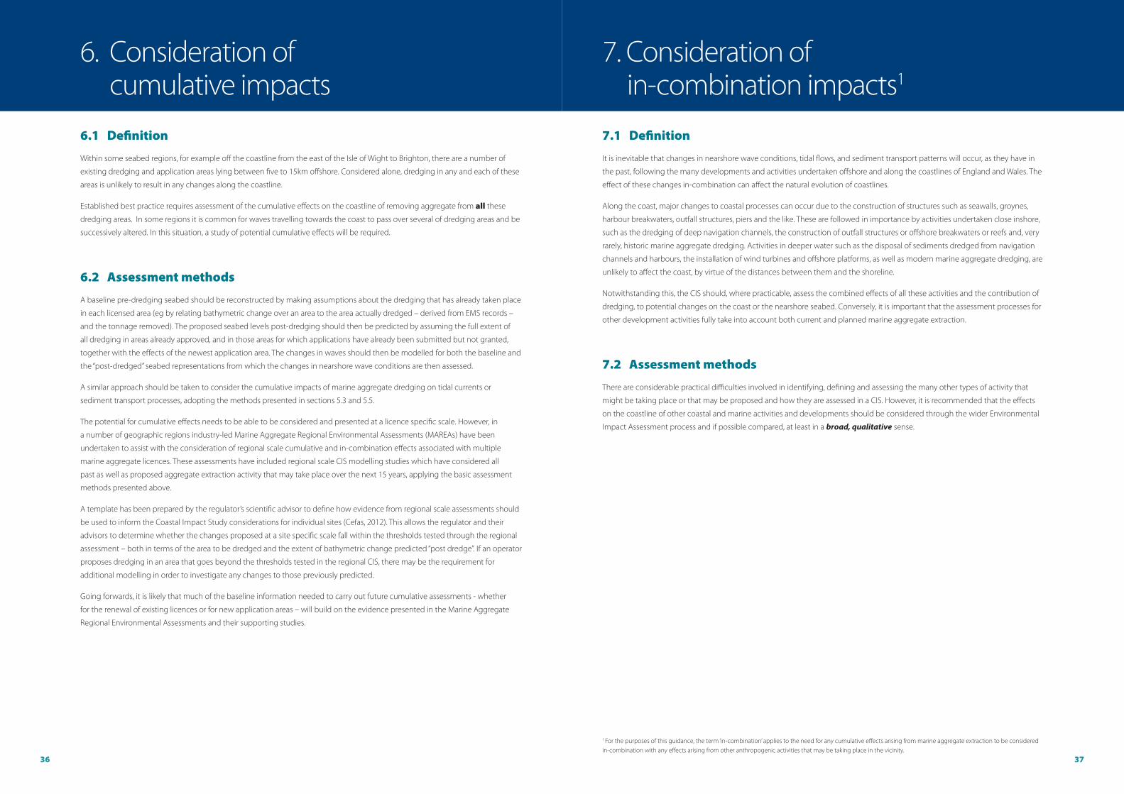
36 37
6.1 Definition
Within some seabed regions, for example off the coastline from the east of the Isle of Wight to Brighton, there are a number of
existing dredging and application areas lying between five to 15km offshore. Considered alone, dredging in any and each of these
areas is unlikely to result in any changes along the coastline.
Established best practice requires assessment of the cumulative effects on the coastline of removing aggregate from all these
dredging areas. In some regions it is common for waves travelling towards the coast to pass over several of dredging areas and be
successively altered. In this situation, a study of potential cumulative effects will be required.
6.2 Assessment methods
A baseline pre-dredging seabed should be reconstructed by making assumptions about the dredging that has already taken place
in each licensed area (eg by relating bathymetric change over an area to the area actually dredged – derived from EMS records –
and the tonnage removed). The proposed seabed levels post-dredging should then be predicted by assuming the full extent of
all dredging in areas already approved, and in those areas for which applications have already been submitted but not granted,
together with the effects of the newest application area. The changes in waves should then be modelled for both the baseline and
the “post-dredged” seabed representations from which the changes in nearshore wave conditions are then assessed.
A similar approach should be taken to consider the cumulative impacts of marine aggregate dredging on tidal currents or
sediment transport processes, adopting the methods presented in sections 5.3 and 5.5.
The potential for cumulative effects needs to be able to be considered and presented at a licence specific scale. However, in
a number of geographic regions industry-led Marine Aggregate Regional Environmental Assessments (MAREAs) have been
undertaken to assist with the consideration of regional scale cumulative and in-combination effects associated with multiple
marine aggregate licences. These assessments have included regional scale CIS modelling studies which have considered all
past as well as proposed aggregate extraction activity that may take place over the next 15 years, applying the basic assessment
methods presented above.
A template has been prepared by the regulator’s scientific advisor to define how evidence from regional scale assessments should
be used to inform the Coastal Impact Study considerations for individual sites (Cefas, 2012). This allows the regulator and their
advisors to determine whether the changes proposed at a site specific scale fall within the thresholds tested through the regional
assessment – both in terms of the area to be dredged and the extent of bathymetric change predicted “post dredge”. If an operator
proposes dredging in an area that goes beyond the thresholds tested in the regional CIS, there may be the requirement for
additional modelling in order to investigate any changes to those previously predicted.
Going forwards, it is likely that much of the baseline information needed to carry out future cumulative assessments - whether
for the renewal of existing licences or for new application areas – will build on the evidence presented in the Marine Aggregate
Regional Environmental Assessments and their supporting studies.
7.1 Definition
It is inevitable that changes in nearshore wave conditions, tidal flows, and sediment transport patterns will occur, as they have in
the past, following the many developments and activities undertaken offshore and along the coastlines of England and Wales. The
effect of these changes in-combination can affect the natural evolution of coastlines.
Along the coast, major changes to coastal processes can occur due to the construction of structures such as seawalls, groynes,
harbour breakwaters, outfall structures, piers and the like. These are followed in importance by activities undertaken close inshore,
such as the dredging of deep navigation channels, the construction of outfall structures or offshore breakwaters or reefs and, very
rarely, historic marine aggregate dredging. Activities in deeper water such as the disposal of sediments dredged from navigation
channels and harbours, the installation of wind turbines and offshore platforms, as well as modern marine aggregate dredging, are
unlikely to affect the coast, by virtue of the distances between them and the shoreline.
Notwithstanding this, the CIS should, where practicable, assess the combined effects of all these activities and the contribution of
dredging, to potential changes on the coast or the nearshore seabed. Conversely, it is important that the assessment processes for
other development activities fully take into account both current and planned marine aggregate extraction.
7.2 Assessment methods
There are considerable practical difficulties involved in identifying, defining and assessing the many other types of activity that
might be taking place or that may be proposed and how they are assessed in a CIS. However, it is recommended that the effects
on the coastline of other coastal and marine activities and developments should be considered through the wider Environmental
Impact Assessment process and if possible compared, at least in a broad, qualitative sense.
6. Consideration of cumulative impacts
7. Consideration of in-combination impacts1
1 For the purposes of this guidance, the term ‘in-combination’ applies to the need for any cumulative effects arising from marine aggregate extraction to be considered in-combination with any effects arising from other anthropogenic activities that may be taking place in the vicinity.

38 39
8.2 Interpreting the Coastal Impact Study assessments
8.1 Synthesising a Coastal Impact Study
All dredging affects the physical marine environment within and adjacent to the extraction area itself. Such effects diminish in
magnitude as the distance from the area that has been dredged increases; they are usually very small beyond about twice the
dimensions of that area. Some effects of dredging, however, may be perceptible further away from the extraction area, particularly
changes in wave conditions and the rates of sand transport over the seabed.
In preparing the overall report on a CIS, it is necessary to explain and combine the assessments made for each of the established
criteria and also address any other specific concerns that were raised during the scoping stage of the Environmental Impact
Assessment. While the assessment methods described in section 5 are applicable to marine aggregate dredging applications off all
parts of the coastline around England and Wales, there is a need to acknowledge and describe the particular local characteristics
and sensitivities of the coastlines considered in each individual CIS.
Finally, in drawing together relevant evidence and the assessments made regarding proposed aggregate dredging, the consultant
should refer to the guiding principles of Coastal Impact Studies, which include being scientifically robust, transparent and
auditable (see section 4.3). In this context, the interpretation of the outcomes of the various assessment techniques and how the
conclusions about the significance of any predicted changes along the coastline have been reached are crucial.
8.2 Interpreting the Coastal Impact Study assessments
The CIS should balance, integrate and report fully on both the physical characteristics of the seabed and coast as well as any
modelling outputs.
Interpretation of physical processes requires bathymetric, geophysical and sample data, for example high resolution side scan
sonar, which should be based upon an adequate data coverage to justify the conclusions, together with well-reasoned and sound
science illustrated with examples and supporting analyses, such as sedimentological data.
Numerical modelling, whether of wave propagation, tidal flows or sediment transport, has the capability to predict very small
changes in these processes at great distances away from a dredging area (see text boxes; pages 38-39). However, such predictions
are unreliable when they become similar in size to the accuracy of the model being used. As a result, the consultant, applicant,
regulator and stakeholders need to be aware that the CIS is only an aid to assessing the significance of changes in nearshore and
coastal conditions. Changes predicted by numerical models need to be interpreted using a good understanding of the physical
processes being investigated. Where changes are small and their location and extent cannot be explained simply, they are likely
to be the result of inaccuracies in the modelling rather than having any physical significance. In this respect, modelling does not
replace the need for judgement, based on experience and all available evidence, including monitoring data from other similar
marine aggregate dredging areas. Where expert judgment is used to consider the nature and potential significance of modelled
changes, for example against the context of the natural environment in which the site is located or the modelling processes
themselves, the additional evidence used to support conclusions should be presented.
An example of the need for interpretation of the assessments carried out in a Coastal Impact Study relates to the computer
modelling of changes in wave conditions. In order to provide a uniform basis for making judgements about the acceptability
of predicted changes in nearshore wave conditions, the assessment should be based on the magnitude of those changes, eg
percentage changes in wave heights or periods across the potentially impacted area. For the purposes of interpretation, a
threshold value of +/-3 per cent for changes in nearshore wave heights or periods has previously been taken as likely to be within
the resolution of the modelling techniques used, as well as being within the likely accuracy of any wave measurements carried
out. Alternatively, measures such as changes in wave energy and associated bed shear stress required to resuspend site specific
sediments may also be considered.
8. Interpreting a Coastal Impact Study
Changes exceeding a defined threshold may still be considered as acceptable, but such an interpretation would require additional
justification and explanation bearing in mind the characteristics of the coastline involved, for example if the frontage affected was
of very durable cliffs (ie not susceptible to coastal erosion). However, if there are no such extenuating circumstances and a clear
indication from the modelling that changes in wave heights or periods will exceed this threshold, even if just for a short length of
coast and only during exceptionally severe wave conditions, then very careful consideration should be given to the acceptability
of proposed marine aggregate dredging.
The conclusions reached about the nature and potential significance of any predicted changes in nearshore wave conditions
will therefore have to be justified in each CIS, in the light of the characteristics of the coastline, the natural variability of wave
conditions, the accuracy to which they can be measured and the resolutions of the models being used to predict them.
Interpretation of seabed sediment transport modelling requires similar analysis of any changes and their significance. Marine
aggregate dredging will only be permitted if it can be demonstrated that it will not adversely affect any existing transport of
sediments from the seabed to the coastline.
In summary, any computational modelling, whether of changes in waves, tidal currents, or sediment transport, can only ultimately
be used as a guide to judgement about the significance of the effects on a coastline from marine aggregate dredging. Modelling
alone cannot replace the need for such a judgement by both the consultant undertaking the CIS or the regulator and their
advisors considering its outputs.
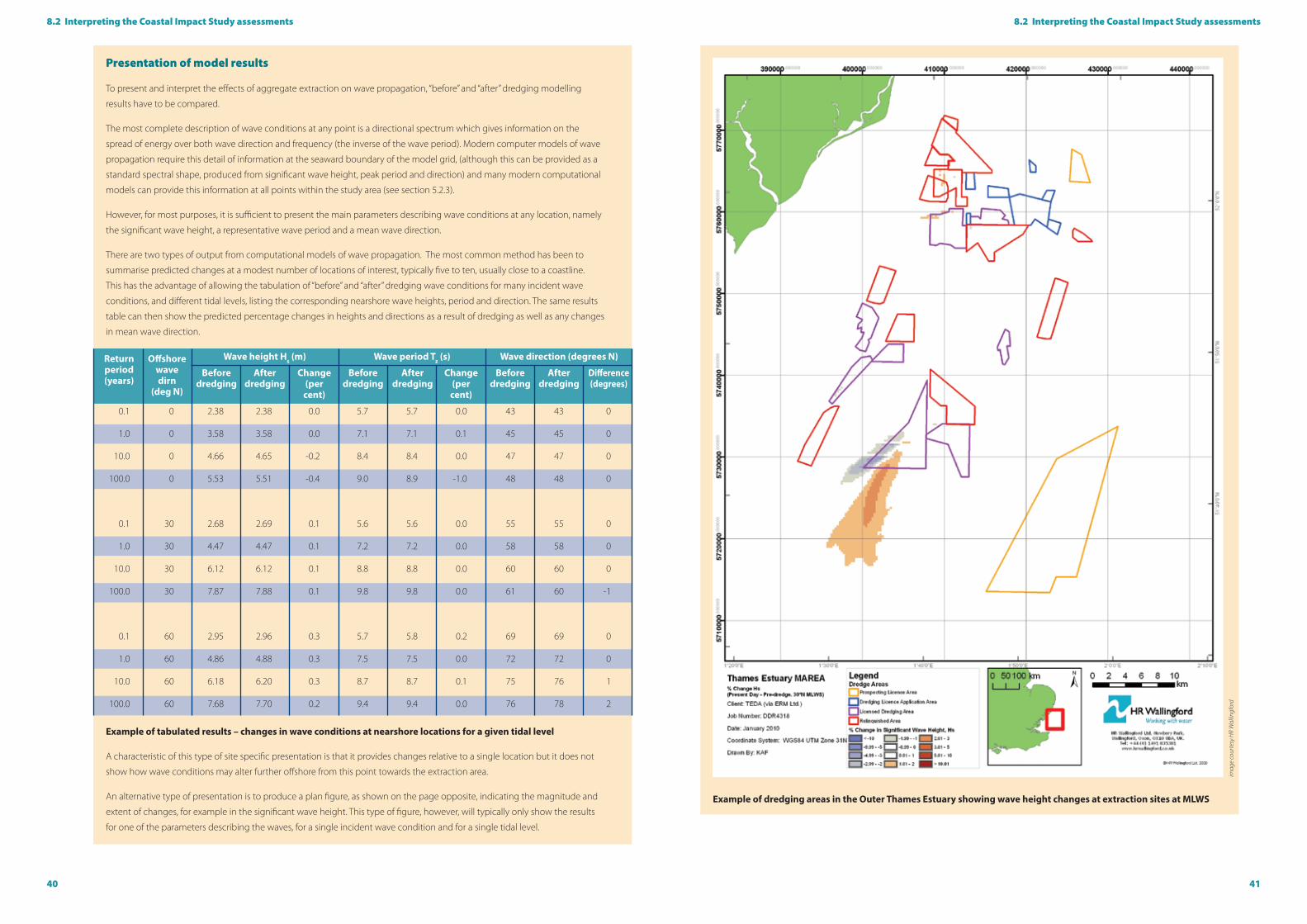
40 41
8.2 Interpreting the Coastal Impact Study assessments8.2 Interpreting the Coastal Impact Study assessments
Example of dredging areas in the Outer Thames Estuary showing wave height changes at extraction sites at MLWS
imag
e co
urte
sy H
R W
allin
gfor
d
Presentation of model results
To present and interpret the effects of aggregate extraction on wave propagation, “before” and “after” dredging modelling
results have to be compared.
The most complete description of wave conditions at any point is a directional spectrum which gives information on the
spread of energy over both wave direction and frequency (the inverse of the wave period). Modern computer models of wave
propagation require this detail of information at the seaward boundary of the model grid, (although this can be provided as a
standard spectral shape, produced from significant wave height, peak period and direction) and many modern computational
models can provide this information at all points within the study area (see section 5.2.3).
However, for most purposes, it is sufficient to present the main parameters describing wave conditions at any location, namely
the significant wave height, a representative wave period and a mean wave direction.
There are two types of output from computational models of wave propagation. The most common method has been to
summarise predicted changes at a modest number of locations of interest, typically five to ten, usually close to a coastline.
This has the advantage of allowing the tabulation of “before” and “after” dredging wave conditions for many incident wave
conditions, and different tidal levels, listing the corresponding nearshore wave heights, period and direction. The same results
table can then show the predicted percentage changes in heights and directions as a result of dredging as well as any changes
in mean wave direction.
Example of tabulated results – changes in wave conditions at nearshore locations for a given tidal level
A characteristic of this type of site specific presentation is that it provides changes relative to a single location but it does not
show how wave conditions may alter further offshore from this point towards the extraction area.
An alternative type of presentation is to produce a plan figure, as shown on the page opposite, indicating the magnitude and
extent of changes, for example in the significant wave height. This type of figure, however, will typically only show the results
for one of the parameters describing the waves, for a single incident wave condition and for a single tidal level.
0.1 0 2.38 2.38 0.0 5.7 5.7 0.0 43 43 0
1.0 0 3.58 3.58 0.0 7.1 7.1 0.1 45 45 0
10.0 0 4.66 4.65 -0.2 8.4 8.4 0.0 47 47 0
100.0 0 5.53 5.51 -0.4 9.0 8.9 -1.0 48 48 0
0.1 30 2.68 2.69 0.1 5.6 5.6 0.0 55 55 0
1.0 30 4.47 4.47 0.1 7.2 7.2 0.0 58 58 0
10.0 30 6.12 6.12 0.1 8.8 8.8 0.0 60 60 0
100.0 30 7.87 7.88 0.1 9.8 9.8 0.0 61 60 -1
0.1 60 2.95 2.96 0.3 5.7 5.8 0.2 69 69 0
1.0 60 4.86 4.88 0.3 7.5 7.5 0.0 72 72 0
10.0 60 6.18 6.20 0.3 8.7 8.7 0.1 75 76 1
100.0 60 7.68 7.70 0.2 9.4 9.4 0.0 76 78 2
Return period (years)
Before dredging
Before dredging
Before dredging
After dredging
After dredging
After dredging
Change (per
cent)
Change (per
cent)
Difference (degrees)
Offshore wave dirn
(deg N)
Wave height Hs (m) Wave period Tz (s) Wave direction (degrees N)

42 43
Where the CIS assessment process indicates that there may be a possible significant impact if a proposed dredging application
were to be permitted, the only practical option for avoiding predicted effects on the coastline would be to modify the proposed
extraction plans. Amendments available to the applicant to mitigate the potential impacts include:
� Reducing the depths of dredging;
� Changing the location of the dredging; and/or
� Changing the configuration or size of the dredging area.
The extent to which such changes in extraction plans will reduce the effects on the coastline will then need to be investigated by
repeating at least one of the assessment methods described in section 5.
In some cases, despite the assessments undertaken in a CIS leading to the conclusion there will be no adverse effects on the coast,
stakeholder concerns may remain. In response, the applicant has an option to limit the proposed dredging, at least initially, to
allow time for more information on its effects to be gathered in order to confirm the predictions and judgements being made.
This approach has been successfully adopted where there are differing views about the effects of dredging on the movements of
sediment across the seabed, or on seabed levels adjacent to the dredging area. By specifying a suitable monitoring exercise (see
section 11) and analysing the data obtained after a few years of extraction, then it should be possible to resolve these concerns,
confirming or modifying the predictions made in the CIS and allowing a decision to be taken about further dredging in the area.
The report on a Coastal Impact Study will typically contain the following sections:
� A non-technical summary (NTS) to support the detailed technical report. The NTS should outline the methods of assessment
and conclusions to the lay reader
� A detailed technical report should contain a comprehensive record of the entire CIS process, together with supporting data
included in an appendix and/or a CD. This report should contain;
A description of the marine aggregate dredging activity being proposed, with details of the extraction area, depths,
quantities and rates of extraction and duration of licence;
A brief review of the geological characteristics of the proposed dredging area, including the aggregate resources and
an interpretation of their origins and their relationship with the existing sedimentary regime;
A general description and explanation of the evolution of the regional seabed and nearshore waters, supported by
a detailed description of the seabed and waters in and around the dredging area, including details of water depths,
seabed sediments, wave and tidal conditions, information on the distribution, composition and transport of seabed
sediments;
A description of nearby coastlines and their past changes and current configuration, highlighting any sensitivities for
example erosion, defences, shoreline management plans and nature conservation designations;
A description of important features in the nearshore zone, such as sandbanks, navigation channels and offshore
structures that might be affected by the proposed dredging;
A statement of the criteria that are used to assess the potential effects of the proposed dredging (see section 5), as well
as cumulative and in-combination effects;
An explanation of how each criterion has been addressed, describing the methods and data used, any assumptions
made, and the conclusions reached;
A description of the numerical modelling containing details on the models, input data, the results and their
interpretation. It is recommended that this information should be provided not only as tables, diagrams and graphs
in the report, but also in digital format if necessary, for example in the form of databases and GIS layers to allow an
independent audit of the modelling;
A conclusion summarising the predicted effects on the coastline of the proposed dredging for all criteria. The
interpretation of the modelling results and seabed data should be carefully explained in relation to predicted changes
at or close to a coastline;
A recommendation for a monitoring programme and potential mechanisms to review the dredging activities.
Throughout the CIS, the use of clear diagrams and charts is recommended to aid understanding. It is likely that there will be
extensive use of previous studies, for example the Marine Aggregate Regional Environmental Assessments, ALSF MEPF projects
and the Southern North Sea Sediment Transport Study. Wherever possible, copies of any previous supporting studies should be
provided in digital form on the CD accompanying the CIS.
Applicants should be prepared to meet local and expert stakeholders to make presentations, explain study results, review their
concerns and adapt aspects of the CIS if required.
9. Mitigating predicted impacts on the coastline
10. Reporting
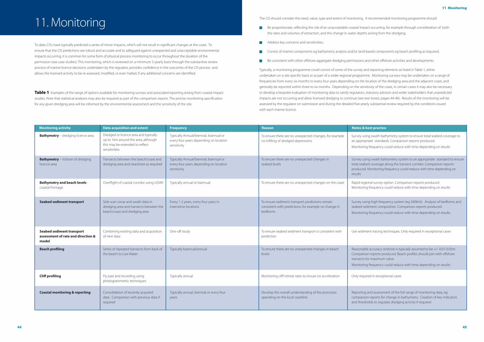
44 45
11 Monitoring
To date, CISs have typically predicted a series of minor impacts, which will not result in significant changes at the coast. To
ensure that the CIS predictions are robust and accurate and to safeguard against unexpected and unacceptable environmental
impacts occurring, it is common for some form of physical process monitoring to occur throughout the duration of the
permission (see case studies). This monitoring, which is reviewed on a minimum 5-yearly basis through the substantive review
process of marine licence decisions undertaken by the regulator, provides confidence in the outcomes of the CIS process and
allows the licensed activity to be re-assessed, modified, or even halted, if any additional concerns are identified.
Table 1 Examples of the range of options available for monitoring surveys and associated reporting arising from coastal impact
studies. Note that statistical analyses may also be required as part of the comparison reports. The precise monitoring specification
for any given dredging area will be informed by the environmental assessment and the sensitivity of the site.
11. Monitoring The CIS should consider the need, value, type and extent of monitoring. A recommended monitoring programme should:
� Be proportionate, reflecting the risk of an unacceptable coastal impact occurring, for example through consideration of both
the rates and volumes of extraction, and the change in water depths arising from the dredging;
� Address key concerns and sensitivities;
� Consist of marine components eg bathymetry analysis and/or land-based components eg beach profiling as required;
� Be consistent with other offshore aggregate dredging permissions and other offshore activities and developments
Typically, a monitoring programme could consist of some of the survey and reporting elements as listed in Table 1, either
undertaken on a site specific basis or as part of a wider regional programme. Monitoring surveys may be undertaken on a range of
frequencies from every six months to every four years depending on the location of the dredging area and the adjacent coast, and
generally be reported within three to six months. Depending on the sensitivity of the coast, in certain cases it may also be necessary
to develop a bespoke evaluation of monitoring data to satisfy regulators, statutory advisors and wider stakeholders that unpredicted
impacts are not occurring and allow licensed dredging to continue (see text boxes; pages 44-46). Results of the monitoring will be
assessed by the regulator on submission and during the detailed five-yearly substantial review required by the conditions issued
with each marine licence.
Bathymetry – dredging licence area
Bathymetry – inshore of dredging licence area
Bathymetry and beach levels - coastal frontage
Dredged or licence area and typically up to 1km around the area, although this may be extended to reflect sensitivities
Transects between the beach/coast and dredging area and nearshore as required
Overflight of coastal corridor using LIDAR
Typically Annual/biennial, biannual or every four years depending on location sensitivity
Typically Annual/biennial, biannual or every four years depending on location sensitivity
Typically annual or biannual
To ensure there are no unexpected changes, for example no infilling of dredged depressions
To ensure there are no unexpected changes in seabed levels
To ensure there are no unexpected changes on the coast
Survey using swath bathymetry system to ensure total seabed coverage to an appropriate standards. Comparison reports produced.
Monitoring frequency could reduce with time depending on results
Survey using swath bathymetry system to an appropriate standard to ensure total seabed coverage along the transect corridor. Comparison reports produced. Monitoring frequency could reduce with time depending on results
Rapid regional survey option. Comparison reports produced. Monitoring frequency could reduce with time depending on results
Monitoring activity Data acquisition and extent Frequency Reason Notes & best practice
Seabed sediment transport
Beach profiling
Coastal monitoring & reporting
Cliff profiling
Seabed sediment transport assessment of rate and direction & model
Side scan sonar and swath data in dredging area and transects between the beach/coast and dredging area
Series of repeated transects from back of the beach to Low Water
Consolidation of recently acquired data. Comparison with previous data if required
Fly past and recording using photogrammetric techniques
Combining existing data and acquisition of new data
Every 1-2 years, every four years in insensitive locations
Typically biannual/annual
Typically annual, biennial or every four years
Typically annual
One-off study
To ensure sediment transport predictions remain consistent with predictions, for example no change in bedforms
To ensure there are no unexpected changes in beach levels
Develop the overall understanding of the processes operating on the local coastline
Monitoring cliff retreat rates to ensure no acceleration
To ensure seabed sediment transport is consistent with prediction
Survey using high frequency system (eg 500kHz). Analysis of bedforms and seabed sediment composition. Comparison reports produced.
Monitoring frequency could reduce with time depending on results.
Reasonable accuracy onshore is typically assumed to be +/- 0.01-0.05m. Comparison reports produced. Beach profiles should join with offshore transects for maximum value.
Monitoring frequency could reduce with time depending on results
Reporting and assessment of the full range of monitoring data, eg comparison reports for change in bathymetry. Creation of key indicators and thresholds to regulate dredging activity if required
Only required in exceptional cases
Use sediment tracing techniques. Only required in exceptional cases
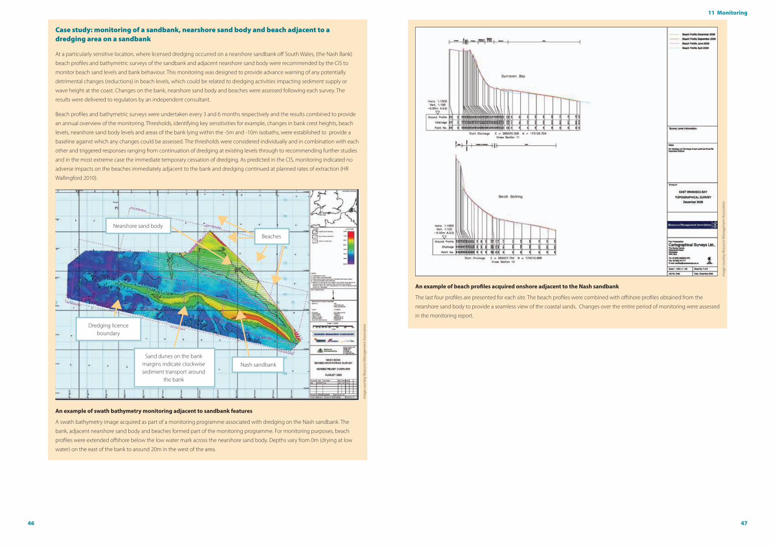
46 47
11 Monitoring
Case study: monitoring of a sandbank, nearshore sand body and beach adjacent to a dredging area on a sandbank
At a particularly sensitive location, where licensed dredging occurred on a nearshore sandbank off South Wales, (the Nash Bank)
beach profiles and bathymetric surveys of the sandbank and adjacent nearshore sand body were recommended by the CIS to
monitor beach sand levels and bank behaviour. This monitoring was designed to provide advance warning of any potentially
detrimental changes (reductions) in beach levels, which could be related to dredging activities impacting sediment supply or
wave height at the coast. Changes on the bank, nearshore sand body and beaches were assessed following each survey. The
results were delivered to regulators by an independent consultant.
Beach profiles and bathymetric surveys were undertaken every 3 and 6 months respectively and the results combined to provide
an annual overview of the monitoring. Thresholds, identifying key sensitivities for example, changes in bank crest heights, beach
levels, nearshore sand body levels and areas of the bank lying within the -5m and -10m isobaths, were established to provide a
baseline against which any changes could be assessed. The thresholds were considered individually and in combination with each
other and triggered responses ranging from continuation of dredging at existing levels through to recommending further studies
and in the most extreme case the immediate temporary cessation of dredging. As predicted in the CIS, monitoring indicated no
adverse impacts on the beaches immediately adjacent to the bank and dredging continued at planned rates of extraction (HR
Wallingford 2010).
An example of swath bathymetry monitoring adjacent to sandbank features
A swath bathymetry image acquired as part of a monitoring programme associated with dredging on the Nash sandbank. The
bank, adjacent nearshore sand body and beaches formed part of the monitoring programme. For monitoring purposes, beach
profiles were extended offshore below the low water mark across the nearshore sand body. Depths vary from 0m (drying at low
water) on the east of the bank to around 20m in the west of the area.
imag
e co
urte
sy R
esou
rce
Man
agem
ent A
ssoc
iatio
n
An example of beach profiles acquired onshore adjacent to the Nash sandbank The last four profiles are presented for each site. The beach profiles were combined with offshore profiles obtained from the
nearshore sand body to provide a seamless view of the coastal sands. Changes over the entire period of monitoring were assessed
in the monitoring report.
imag
e co
urte
sy R
esou
rce
Man
agem
ent A
ssoc
iatio
n
Beaches
Nash sandbank
Nearshore sand body
Dredging licence boundary
Sand dunes on the bank margins indicate clockwise sediment transport around
the bank

48 49
BMAPA and The Crown Estate, 2010. Marine Aggregate Terminology: A Glossary.
Cefas, 2013. REAs and CIS – a draft template of suitable evidence.
CIRIA, 1998. Regional seabed sediment studies and assessment of marine aggregate dredging. CIRIA Report C505.
Communities & Local Government (published by Office of the Deputy Prime Minister), 2002. Marine Minerals Guidance Note 1
(MMG1): Marine Mineral Guidance 1: Extraction by dredging from the English seabed
Communities & Local Government, 2010. Planning Policy Statement 25: Development and Flood Risk.
Communities & Local Government, 2012. National Planning Policy Framework.
Environment Agency, 1999. The state of the Environment of England and Wales: Coasts. The Stationery Office, London.
Halcrow, 2002. Futurecoast. CD-ROM, produced for Department of the Environment, Food & Rural Affairs. Halcrow, Swindon, UK.
Highley, D E, Hetherington, L E, Brown, T J, Harrison, D J and Jenkins, G O, 2007. The strategic importance of the marine aggregate
industry to the UK. British Geological Survey Research Report, OR/07/019.
HR Wallingford, 2010. Analysis of Beach and Seabed Levels 2003 to 2009, Report EX6333
HM Government, 2011. UK Marine Policy Statement. The Stationary Office, London.
ICES, 2012. Report of the working Group on the Effects of Extraction of Marine Sediments on the Marine Ecosystem (WGEXT),
April 2012, Rouen, France. ICES CM 2012/SSGHIE:11.
Institution of Civil Engineers (ICE), 2002. ICE Design and Practice Guides: Coastal Defence.
Melia, S, 2002. Hallsands: a village betrayed. Forest Publishing Newton Abbot.
National Museum & Galleries of Wales and British Geological Survey, 2006. Outer Bristol Channel Marine Habitats Study
Selby, I C, 2011. Marine sand and gravel supply looking 50 years ahead – the challenge for planning. The Crown Estate.
Welsh Assembly Government, 2004. Interim Marine Aggregate Dredging Policy
Welsh Assembly Government, 2004. Technical Advice Note 15: Development and Flood Risk in Wales
12. ReferencesCase study: monitoring of dredging adjacent to a sandbank
Bathymetric and side scan sonar monitoring of a dredging area lying adjacent to a sandbank offshore East Anglia was undertaken
to ensure the sandbank was not drawn-down into the dredging zone. The CIS recommended annual monitoring surveys of
complete seabed bathymetric coverage in the region, with annual reports comparing bathymetric changes, particularly focusing
on the base of the bank. The analyses have highlighted the substantial natural changes occurring on the bank. Whilst the
sandbank shape and margin continually adjusted throughout the five years of monitoring, there was no evidence of the sand
moving away from the sandbank into the dredged areas, which remained as unfilled depressions.
An example of swath bathymetry monitoring on a sandbank feature
A swath bathymetry image acquired for monitoring seabed sediment transport and sandbank behaviour around a dredging
licence off East Anglia. The dredging area lies immediately to the east of the South Cross Sand sandbank and south of the Middle
Cross Sands sandbank. The seabed is relatively flat and lies at depths of around 25m. Tidal currents flow north-south. The seabed
in the dredged areas lies about 2m below the adjacent seabed and remains unfilled despite being only 500m from the sandbank
margin. This indicates that the dredging area does not draw-down sand from the bank and bedform evidence suggests that sand
is being transport parallel to the bank margin as predicted in the CIS.
Middle Cross Sands sandbank
Sand dunes
Dredged areas
Flat seabed – no bedforms are present that indicate east-west
sediment transport
South Cross Sands sandbank – drying at low water
imag
e co
urte
sy H
anso
n Ag
greg
ates
Mar
ine
Ltd
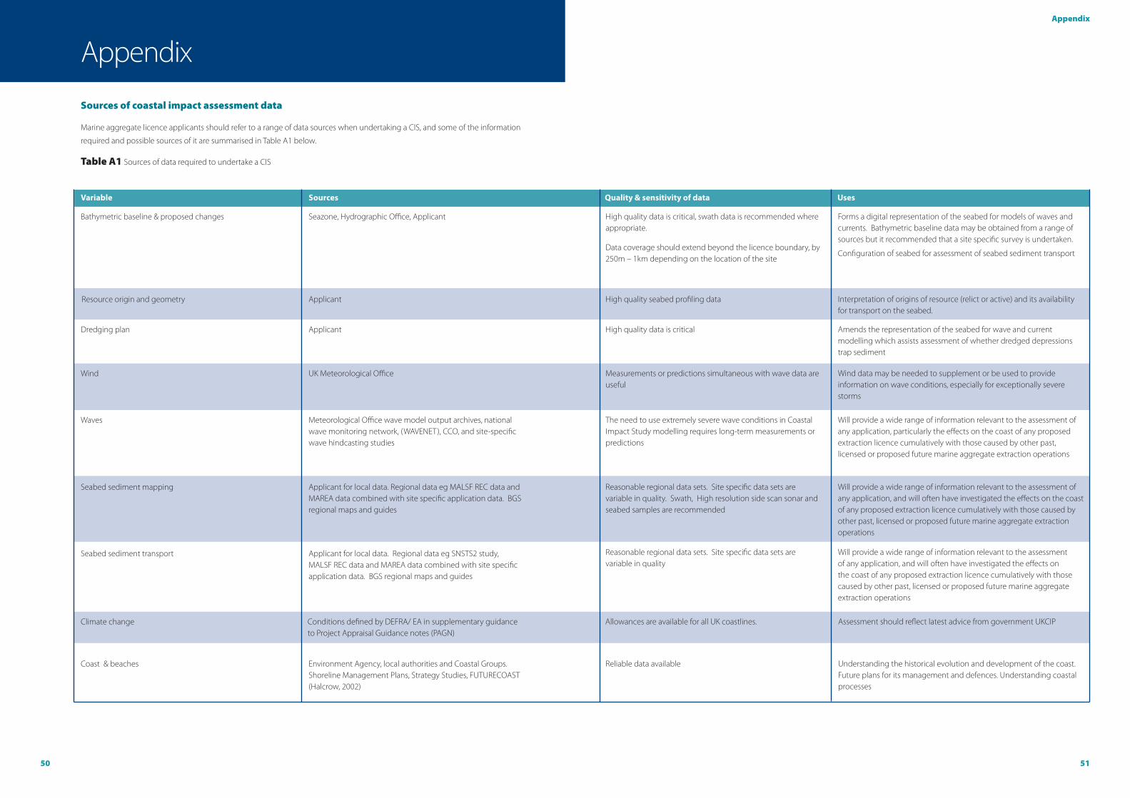
50 51
Appendix
Sources of coastal impact assessment data
Marine aggregate licence applicants should refer to a range of data sources when undertaking a CIS, and some of the information
required and possible sources of it are summarised in Table A1 below.
Table A1 Sources of data required to undertake a CIS
Bathymetric baseline & proposed changes
Seabed sediment transport
Climate change
Coast & beaches
Resource origin and geometry
Dredging plan
Wind
Waves
Seabed sediment mapping
Seazone, Hydrographic Office, Applicant
Applicant for local data. Regional data eg SNSTS2 study, MALSF REC data and MAREA data combined with site specific application data. BGS regional maps and guides
Conditions defined by DEFRA/ EA in supplementary guidance to Project Appraisal Guidance notes (PAGN)
Environment Agency, local authorities and Coastal Groups. Shoreline Management Plans, Strategy Studies, FUTURECOAST (Halcrow, 2002)
Applicant
Applicant
UK Meteorological Office
Meteorological Office wave model output archives, national wave monitoring network, (WAVENET), CCO, and site-specific wave hindcasting studies
Applicant for local data. Regional data eg MALSF REC data and MAREA data combined with site specific application data. BGS regional maps and guides
High quality data is critical, swath data is recommended where appropriate.
Data coverage should extend beyond the licence boundary, by 250m – 1km depending on the location of the site
Reasonable regional data sets. Site specific data sets are variable in quality
Allowances are available for all UK coastlines.
Reliable data available
High quality seabed profiling data
High quality data is critical
Measurements or predictions simultaneous with wave data are useful
The need to use extremely severe wave conditions in Coastal Impact Study modelling requires long-term measurements or predictions
Reasonable regional data sets. Site specific data sets are variable in quality. Swath, High resolution side scan sonar and seabed samples are recommended
Forms a digital representation of the seabed for models of waves and currents. Bathymetric baseline data may be obtained from a range of sources but it recommended that a site specific survey is undertaken.
Configuration of seabed for assessment of seabed sediment transport
Will provide a wide range of information relevant to the assessment of any application, and will often have investigated the effects on the coast of any proposed extraction licence cumulatively with those caused by other past, licensed or proposed future marine aggregate extraction operations
Assessment should reflect latest advice from government UKCIP
Understanding the historical evolution and development of the coast. Future plans for its management and defences. Understanding coastal processes
Interpretation of origins of resource (relict or active) and its availability for transport on the seabed.
Amends the representation of the seabed for wave and current modelling which assists assessment of whether dredged depressions trap sediment
Wind data may be needed to supplement or be used to provide information on wave conditions, especially for exceptionally severe storms
Will provide a wide range of information relevant to the assessment of any application, particularly the effects on the coast of any proposed extraction licence cumulatively with those caused by other past, licensed or proposed future marine aggregate extraction operations
Will provide a wide range of information relevant to the assessment of any application, and will often have investigated the effects on the coast of any proposed extraction licence cumulatively with those caused by other past, licensed or proposed future marine aggregate extraction operations
Variable Sources Quality & sensitivity of data Uses
Appendix

52
The Crown Estate - London16 New Burlington Place
London
W1S 2HX
T 020 7851 5080
W www.thecrownestate.co.uk
© The Crown Estate
British Marine Aggregate Producers AssociationGillingham House
38-44 Gillingham Street
London
SW1V 1HU
T 020 7963 8000
W www.bmapa.org
ISBN: 978-1-906410-50-6
The Crown Estate - Edinburgh6 Bell’s Brae
Edinburgh
EH4 3BJ
T 0131 260 6070
Printed onto 100% recycled paper
Disclaimer
BMAPA and The Crown Estate are not liable for the accuracy of the information provided or responsible for any use of the content.