Embed Size (px)
Citation preview

March 19, 2008 7th Annual Surface Water Monitoring and Standards
NWQM Network for Coastal Waters– Overview and Lake Michigan Pilot
Sue Brauer U.S. EPA Region 5
Land and Chemicals Division

March 19, 2008 7th Annual Surface Water Monitoring and Standards
NMN: When? Who? How?1991 OMB Memo 92-01 Water Information Coordination Program From Two to
One Committee
1992 Interagency Task Force on Monitoring Water Quality (1992-1997)
1996 FACA Advisory Committee on Water Information (ACWI) chartered
1997 National Water Quality Monitoring Council -ACWI subgroup
1997 ACWI first meeting
2000 Ocean Policy Act of 2000 & Commission 2000-2004
2004 U.S. Commission on Ocean Policy: Ocean Blueprint for the 21st Century Ch. 15 - NMN
2004 Bush Admin. Ocean Action Plan (E.O. 13366)
2005 CEQ, National Science and Technology Council Subcommittees on Oceans and Water Availability & Quality) ACWI ->NWQMC->NMN
2006 National Water Quality Monitoring Network for U.S. Coastal Waters and Their Tributaries by ACWI & NWQMC
2008 Pilot Reports

March 19, 2008 7th Annual Surface Water Monitoring and Standards
CEQ & NSTC to National Water Quality Monitoring Council
• Recommend a national monitoring network design that– Addresses and integrates watershed, coastal waters, and ocean
monitoring, based on common criteria and standards. – Provides information on water quality that would provide relevant
scientific information to assist resource management and decision making
– Identify the major overarching management questions that need to be addressed and the fundamental elements of this national monitoring network (such as atmospheric deposition, surface water, ground water, and water quality, including biological monitoring), emphasizing the “federally funded backbone” of water quality networks and programs
• Tasks include case studies, identifying gaps in data and data networks for answering management questions, assessing resources, and compatibility with IOOS

March 19, 2008 7th Annual Surface Water Monitoring and Standards
Ocean.USThe National Office forIntegrated and Sustained Ocean Observations
Printer Friendly
The National Water Quality Monitoring Network for U.S. Coastal Waters and their Tributaries Pilot Phase Begins.2 April 2007 – 10:25am The U.S. EPA's Office of Water, working with the USGS and NOAA, has received twelve (12) expressions of interest in implementing the initial pilot phase of the new National Water Quality Monitoring Network for U.S. Coastal Waters and their Tributaries. The network will provide observations of pollution loads conveyed from inland watersheds to coastal waters through eight (8) linked “resource components” in the hydrologic system. The Pilot Studies will examine the effort needed to integrate the new network requirements into existing monitoring programs located in selected Regions of the U.S.The U.S. Committee on Ocean Policy (http://ocean.ceq.gov/) directed these three federal agencies to solicit expressions of interest after committees implementing the Ocean Action Plan accepted the national coastal monitoring network design. The new network was designed by 80 volunteers working through the National Water Quality Monitoring Council, including Staff from EPA's Office of Research and Development (ORD & EMAP).

March 19, 2008 7th Annual Surface Water Monitoring and Standards
Lake Michigan Pilot

March 19, 2008 7th Annual Surface Water Monitoring and Standards
NMN/Great Lakes Compartments
• Estuaries• Nearshore• Offshore• Great Lakes• Rivers• Ground Water• Atmospheric Deposition• Beaches• Wetlands
• Embayments• GL Shallow Nearshore• GL Medium Nearshore• GL Offshore• Rivers• Ground Water• Atmospheric Deposition• Beaches• Wetlands

March 19, 2008 7th Annual Surface Water Monitoring and Standards
Great Lakes Embayments• Lake Michigan
– Calumet Harbor, IN– Baileys Harbor, WI– Little Bay de Noc, WI– Moonlight Bay, WI– Ephrain, WI – Little Sturgeon Bay, WI– Rowley Bay, WI– Little Traverse Bay, MI– North Bay– Big Bay de Noc, WI– Milwaukee Harbor, WI– Suttons Bay, MI– Indiana Harbor, IN
• Sampling design not specified

March 19, 2008 7th Annual Surface Water Monitoring and Standards
Great Lakes Near-/Off-shore
Lake
ShallowMedium Near-shore Bound-ary (m)
% of Area
Near shore/Off- shore Bound-ary (m)
% of area within Near-shore
Mean Depth
(m)
Superior 30 10.0 150 50.0 149
Michigan
30 25.9 80 51.4 85
Huron 20 25.1 50 51.9 59
Erie 10 19.5 20 54.8 19
Ontario 30 24.0 80 50.4 86

March 19, 2008 7th Annual Surface Water Monitoring and Standards
NMN Management QuestionsLake Michigan Pilot Answers
• What is the Condition of the Nation’s surface, ground, estuarine, and coastal waters?
• Look at the CWA 303(d)/305(b) consolidated reports State-by-State because pulling the data is too hard. NWIS is easy, GLENDA is easy, STORET data entered by all states?
• From shallow near shore to offshore, condition is unknown

March 19, 2008 7th Annual Surface Water Monitoring and Standards
NMN Management QuestionsLake Michigan Pilot Answers
• Where, how, and why are water quality conditions changing over time?
• States do river water quality
• Lake Michigan monitored >80 m
• Beach monitoring via Beach Act grants
• AOCs monitored via state 5 year rotation
• < 80 m depth at drinking water intakes and at southern end
• GLFMP tells a good story

March 19, 2008 7th Annual Surface Water Monitoring and Standards
NMN Management QuestionsLake Michigan Pilot Answers
Depend on Location• Where/What are
problems related to water quality?
• Beaches-pathogens• Fish-contaminants• Nutrient enrichment• Nuisance algal
blooms• Habitat degradation• Aquatic invasive
species

March 19, 2008 7th Annual Surface Water Monitoring and Standards
NMN Management QuestionsLake Michigan Pilot Thoughts
• What is causing the problems?– Beaches-pathogens– Fish-contaminants– Nutrient enrichment– Nuisance algal blooms– Habitat degradation– Aquatic invasive
species
• Measurement tool, source identification
• Legacy pollutants, limited testing
• Nonpoint sources of nutrients
• Inc. load or changed P cycle in lake?
• Invasive species• Human society

March 19, 2008 7th Annual Surface Water Monitoring and Standards
NMN Management QuestionsLake Michigan Pilot Thoughts
• Are programs to prevent or remediate problems working effectively?
• Limited (negotiated in lieu of mandatory) monitoring data at remediation sites limits ability to answer.
• Grand Calumet shows improvement
• TSCA ban on PCBs and FIFRA cancellations evident
• Is technical infeasibility a problem for NPDES permits limiting PCBs and mercury?

March 19, 2008 7th Annual Surface Water Monitoring and Standards
NMN Management QuestionsLake Michigan Pilot Thoughts
• What research activities are needed to support these important resources and ensure they are understood and sustainable?
• More nutrient monitoring of the shallow and medium nearshore for comparable metrics and source identification
• Semi-permeable membrane device monitoring of regulated bioaccumulative toxic substances for a load metric not affected by changes in the food web
• Method development, computational toxicology, and rapid screening for polllutants

March 19, 2008 7th Annual Surface Water Monitoring and Standards
NMN Refinement Summary Report
• Available February 2008 http://acwi.gov/monitoring/network/
• Nutrients: lists required parameters and performance requirements
• Contaminants: 243 compounds– 28 metals/metaloids, 47 VOCs, 40 pesticides, 57
halogenated hydrocarbons, 71 PAHs
• Wetlands: 3 tiers– Landscape Level detected remotely, Rapid
Assessment in the field by trained personnel, & Intensive Observations laboratory

March 19, 2008 7th Annual Surface Water Monitoring and Standards
NMN Refinement Summary Report• Biology: number, frequency, interval undetermined
– Macroalgae density; Habitat mapping; Seagrass cover; DELTs; Sediment Quality Triad; Dissolved oxygen level; HABs; Status of an “ecologically significant” species in an estuary; Epiphytes; Chlorophyll a; Macrobenthic Fauna; Bird Community Census; Status of Marine animal considered sentinel of environmental change; Commercial fish & shell fish landings; Presence of non-indigenous species; WQI; Coastal Habitat Index; Sediment Quality Index
• Atmospheric Deposition: benchmark stations and supporting stations every 7-24 days to coordinate with other sampling, one site per estuary, over water– Wet deposition nitrate, ammonium, and organic nitrogen, methyl
and total mercury– Dry deposition gaseous ammonia, oxidized nitrogen species,
particulate nitrate and ammonium, mercury (meas. or est.)– Deposition of PAHs, PCBs, SVOCs

March 19, 2008 7th Annual Surface Water Monitoring and Standards
Pilot Report Gap Analysesw=water, s=sediments, c=contaminants, b=biology, p=physical char.
• Pilots didn’t agree how to count: – By number of measurements relative to design– By proportion of requested contaminants– By number of states out of four– By number of reporting units, number of sites per
reporting unit, total number of sites, sample frequency or interval . . .

March 19, 2008 7th Annual Surface Water Monitoring and Standards
Lake Michigan Pilot ReportContaminants Example
• Database began with NAWQA analyte list– WI Long Term Trends Ambient Water Quality Network– IL Lake Michigan Basin– IN Rotating Basin, Statewide Fixed Station– MI Water Chemistry Monitoring Program– GLNPO Limnology Program in Offshore– GLNPO Fish Monitoring Program– Integrated Air Deposition Network– NOAA Mussel Watch

March 19, 2008 7th Annual Surface Water Monitoring and Standards
Lake Michigan Pilot Report Contaminants
(cont.)– All states monitor temperature, pH, chloride, cadmium,
chromium, copper, nickel, sodium, zinc, PCBs in fish and/or water, and mercury in tissue and/or water
– Of these 11 common parameters, GLNPO reports total PCBs in its fish monitoring program, representing the off shore while Mussel Watch and IADN report on a congener-specific basis representing the shallow near shore. IADN reports on both a congener-specific basis and a total PCB basis.
March 19, 2008 7th Annual Surface Water Monitoring and Standards
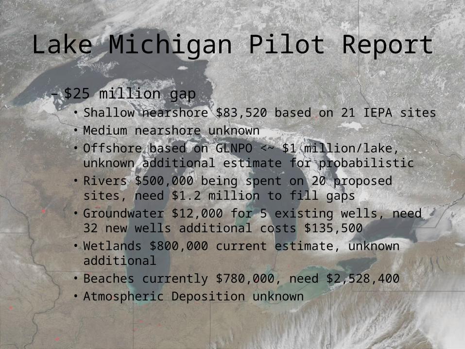
Lake Michigan Pilot Report
– $25 million gap• Shallow nearshore $83,520 based on 21 IEPA sites• Medium nearshore unknown• Offshore based on GLNPO <~ $1 million/lake, unknown
additional estimate for probabilistic• Rivers $500,000 being spent on 20 proposed sites, need
$1.2 million to fill gaps• Groundwater $12,000 for 5 existing wells, need 32 new wells
additional costs $135,500• Wetlands $800,000 current estimate, unknown additional• Beaches currently $780,000, need $2,528,400• Atmospheric Deposition unknown

March 19, 2008 7th Annual Surface Water Monitoring and Standards
Acknowledgements
GLC: John Hummer, Jon DettlingUSGS: Charlie Peters, Dale Robertson, Kevin Richards,
Norm Grannemann, Gary Rowe, Sandra MorrisonIEPA: Gregg Good, Joe Marencik, Tammy MitchellIDEM: Art GarceauWDNR: Steve Galarneau, Jim BaumannMDEQ: Gary Kohlhepp, Julie Sims, Jim Bredin, Tracy
CollinU.S. EPA: Chuck Spooner, Johnr Kelly, Sarah Lehmann,
Glenn Warren and GLNPO Monitoring Team, Dean Maraldo
UW-Milwaukee: Harvey Bootsma