Embed Size (px)
Citation preview

Report on the investigation of
the collision between the
UK registered fishing vessel
Marbella
and the
Bravo Delta offshore platform
in the Rough Gas Field
about 25 miles south-east of Flamborough Head
8 May 2002
Marine Accident Investigation BranchFirst Floor
Carlton HouseCarlton PlaceSouthampton
United Kingdom SO15 2DZ
Report No 11/2003September 2003

Extract from
The Merchant Shipping
(Accident Reporting and Investigation)
Regulations 1999
The fundamental purpose of investigating an accident under the MerchantShipping (Accident Reporting and Investigation) Regulations 1999 is todetermine its circumstances and the causes with the aim of improving the safetyof life at sea and the avoidance of accidents in the future. It is not the purposeto apportion liability, nor, except so far as is necessary to achieve thefundamental purpose, to apportion blame.
This report is not written with liability in mind and is not intended to be used incourt for the purpose of litigation. It endeavours to identify and analyse therelevant safety issues pertaining to the specific accident, and to makerecommendations aimed at preventing similar accidents in the future.

CONTENTSPage
GLOSSARY OF ABBREVIATIONS AND ACRONYMS
SYNOPSIS 1
SECTION 1 - FACTUAL INFORMATION 3
1.1 Particulars of Marbella and accident 31.2 Narrative 4
1.2.1 Events leading up to the collision - Marbella 41.2.2 Events leading up to the collision - Putford Achilles 51.2.3 Events after the collision 7
1.3 Environmental conditions 81.4 The Rough Gas Field 9
1.4.1 Description 91.4.2 Damage 11
1.5 Marbella 111.5.1 The vessel 111.5.2 The crew 131.5.3 Navigational equipment, practices, instructions and guidelines 141.5.4 Damage 17
1.6 Putford Achilles 171.6.1 The vessel 171.6.2 The master 181.6.3 Navigational and communication equipment 181.6.4 Relevant extracts from Dynegy’s instructions to stand-by
vessels and for emergencies 181.6.5 Extracts from Putford’s operating procedures 19
1.7 Action since taken by the Maritime and Coastguard Agency (MCA) 20
SECTION 2 - ANALYSIS 21
2.1 Aim 212.2 The collision 21
2.2.1 Sources of information and its analysis 212.2.2 Second mate’s actions 222.2.3 Voyage planning 25
2.3 Collision prevention 262.3.1 Putford Achilles 262.3.2 Installation-based radar 28
SECTION 3 - CONCLUSIONS 30
3.1 Causal factors 303.2 Other findings 31
SECTION 4 - ACTION TAKEN 32
Annex MCA Safety Alert

GLOSSARY OF ABBREVIATIONS AND ACRONYMS
ARPA - Automatic radar plotting aid
DEFRA - Department for Environment, Food and Rural Affairs
DSC - Digital selective calling
CPA - Closest point of approach
EBL - Electronic bearing line
FRC - Fast rescue craft
GPS - Global positioning system
HF - High frequency
IMO - International Maritime Organization
kW - kilowatt
m - metre
MF - Medium frequency
MGN - Marine Guidance Note
OIM - Offshore installation manager
OOW - Officer of the watch
RNLI - Royal National Lifeboat Institution
ROV - Remotely operated vehicle
VHF - Very high frequency
VTS - Vessel traffic service

SYNOPSIS
At 0936 (UTC+1) on 8 May 2002, the stern freezer trawlerMarbella collided with the BD platform of the Bravo installationin the Rough Gas Field, off the coast of East Yorkshire. Thefishing vessel suffered severe damage to the starboard bow,but there was relatively minor damage to the platform’s jacket.There were no injuries and no pollution. Humber Coastguardinformed the MAIB of the accident at 1141 that day.
Marbella left Alexandra Dock in Hull at 0425 on 8 May andcarried out compass adjustments in the River Humber. Oncethe adjustments had been finished and the compass adjusters
had been disembarked, she continued downriver to the sea to begin her passage tothe fishing grounds in the Arctic Circle near Spitsbergen. The pilot disembarked at0800 and the skipper and mate took the vessel through the traffic separation scheme.At 0845, just after the vessel had passed the N New Sands buoy, the skipper andmate went below, after handing over the watch to the second mate. The course hadbeen set at 015° and the speed was about 13 knots. The visibility was between 1 and2 miles. A lookout was on the bridge. The second mate saw the radar echo of what heinterpreted to be the Rough Gas Field within the 12-mile range and on his starboardbow.
After a period of time, a routine engine room alarm sounded, and the second matethen walked around the bridge to make checks on the different systems. When hereturned to the radar, he could not identify the echo of the Rough Gas Field. Thevisibility had reduced to about half a cable. The lookout shouted to the effect that theplatform was ahead and the second mate quickly turned the automatic helm to port,but a collision with the platform ensued.
The master of the stand-by vessel, Putford Achilles, had plotted the approachingfishing vessel, and had tried to make contact with her by VHF radio before theaccident, without success. A fault was later found with the VHF radio equipment. Non-essential crew were evacuated from the installation by helicopter to a nearby tanker,which had a helicopter deck, and to Humberside airport. An RNLI lifeboat and a tugescorted the vessel back to Hull, without further incident.
A number of causal factors led to this collision, including the lack of a satisfactoryvoyage plan and proper position plotting in relation to the installation, and anunexplained alteration of course to starboard some 6 minutes before the collision.
The MCA initiated discussions with the offshore and fishing industries with the aim ofreducing the number of future similar incidents and near misses, and has produced aSafety Alert.
Chief Inspector’s letters have been sent to Boston Putford Safety Ltd and Marr FishingVessel Management Limited, with respect to reinforcing existing company operatinginstructions and procedures relating respectively to potential infringements of thesafety zone of offshore installations and effective passage planning and monitoring.
1

2
Marb
ella
Photograph 1

3
SECTION 1 - FACTUAL INFORMATION
1.1 PARTICULARS OF MARBELLA AND ACCIDENT
Vessel details
Registered owner : Armana Limited
Manager : Marr Fishing Vessel Management Limited
Port of registry : Hull
Flag : UK
Type : Stern freezer trawler
Built : 1989 in Norway
Classification society : Det Norske Veritas
Construction : Steel
Length overall : 69.60m
Gross tonnage : 2880
Engine power : 2424kW
Accident details
Time and date : 0936 (UTC +1) on 8 May 2002
Location of incident : Latitude 53° 49.95’N longitude 000° 26.45’ ERough Gas Field about 25 miles south-east ofFlamborough Head
Persons on board : 21
Injuries/fatalities : None
Damage : Extensive damage to Marbella’s starboard bow

4
1.2 NARRATIVE
1.2.1 Events leading up to the collision - Marbella
All times are UTC + 1 and all courses and bearings are true.
After the crew members had joined Marbella at Alexandra Dock in Hull, androutine checks had been made, the vessel let go at about 0425 on 8 May 2002.A pilot and two compass adjusters were on board. Once in the River Humber,the vessel was swung to adjust the magnetic compass. Once completed, thetwo adjusters disembarked at Riverside Quay at about 0540. The vessel let goat about 0600 and began her passage downriver to the sea. Her destination wasthe fishing grounds off Spitsbergen, in the Arctic Circle.
Before departure, the skipper and the mate had discussed and agreed a watchroster, and the second mate had been informed that he was to take the firstwatch with a lookout.
The second mate had been on the fo’c’sle head during the compass adjustment;he had then helped in preparing the vessel for sea, after which he had gone tohis cabin to sort out his personal gear. He was then summoned to assist indisembarking the pilot before returning to his cabin. The pilot disembarked nearthe SE Chequer buoy at about 0800. The skipper and the mate then navigatedthe vessel through the New Sand traffic separation scheme towards the N NewSand buoy. About 15 minutes later, the bridge bell sounded and the secondmate went to the bridge. By this time, about 0845, Marbella had passed the NNew Sand buoy and the course had been set to 015°. He was joined by a sparehand who was to act as lookout. The visibility was about 1.5 miles. Once theskipper and the mate had handed over the watch to the second mate, they leftthe bridge.
Both radars were in operation; one was set on the 12-mile range, which had anARPA facility, and the other was on the 6-mile range. The mate had explainedthe traffic movements on the ARPA radar and had identified a large echo tostarboard of the heading line as the Rough Gas Field. Both radars were gyrostabilised and in the north-up mode. The second mate subsequently placed theEBL on what he interpreted was the echo nearest the heading line. He saw thatthe bearing was 022° and that the echo was drawing to starboard off the EBL. Apaper chart was in use and a course line of 015° had been drawn on it. Theautomatic helm was in operation.
After a period of time, a routine engine room alarm activated on the forwardconsole. The second mate got out of the wheelhouse chair and walked aroundthe bridge to make checks on the different systems. He returned to the chairand, looking at the radar screen, interpreted that the echo of the Rough GasField had been lost in the clutter. He then changed the range scale to 3 milesand still could not see the echo. There is conflicting evidence as to what the

5
second mate said to the lookout concerning the echo. The lookout wasstanding to port of the forward console. The visibility, by this time, had reducedto about half a cable. The second mate then spent his time trying to distinguishthe echo on the radar.
The lookout shouted to the second mate to the effect that the platform was rightahead. The second mate looked up and saw the platform was on the starboardbow and very close. He went to the automatic helm and altered course to port.However, Marbella’s starboard bow struck the south-west leg of the Bravo Deltajacket of the Rough Gas Field Bravo installation (see Diagram 1). Soonafterwards, the skipper and the mate arrived on the bridge.
1.2.2 Events leading up to the collision - Putford Achilles
At about 2000 on 6 May 2002, Putford Ajax relieved Putford Achilles from herstand-by duties at the Rough Gas Field so that the latter could proceed onpassage to Immingham for cargo operations. At 0120 the following morning, shewas fast alongside and, soon after, began loading fuel oil and potable water. At1150, all cargo operations were completed. She remained alongside until 0015on 8 May 2002, when she sailed for the Rough Gas Field. At 0430, PutfordAchilles relieved Putford Ajax and resumed her normal stand-by duties.
At 0730, the master relieved the second mate and took over the navigationalwatch. At that time the vessel was stationed, according to standard procedures,down-tide and on the north side of the installation.
Four fishing vessels were working in the area within 4 miles of the installationbut none within the 500m zone. One radar was on the 12-mile range scale andthe other was on the 2-mile range scale. The master chose not to use the guardzone on the former radar because of the fishing vessel activity. He noted anumber of other echoes, including that of Marbella, which was approaching fromthe south at a range of about 12 miles. His interpretation of the movement andsize of Marbella’s echo did not indicate to him anything different from the normalapproach and activity of fishing vessels which operate in the area in and aroundthe Rough Gas Field. From past experience, when the master could identifylocal fishing vessels which operated in the area, he routinely ignored hiscompany’s operating procedures for potential infringements of the safety zone.However, he was unable to identify Marbella’s echo, because of the restrictedvisibility, and was uncertain that she was one of the local fishing vessels thatnormally operated in the area.
When Marbella’s echo was 3.15 miles from the installation, the master beganplotting it. Shortly afterwards, the plot showed that the other vessel would passabout 1 cable to the west of the installation. He then attempted to call theapproaching vessel on VHF radio channels 16 and 72, the latter frequency beinggenerally used by local fishing vessels. The master believed the echo was asmall fishing vessel and he did not alert the installation of her approach. There

6
A reconstruction of the collision of Marbella with BD platform
Diagram
1

7
was no reply from the vessel, nor did she alter course. The master began tomove Putford Achilles around the installation to identify the passing vessel. Hethen heard a “Pan Pan” message broadcast from Marbella indicating that shehad collided with the installation.
1.2.3 Events after the collision
Marbella’s skipper broadcast a “Pan Pan” message on VHF radio channel 16,giving his vessel’s position, that she had been in collision with a rig (platform) inthe Rough Gas Field, and that no one on board had been injured. HumberCoastguard responded to the message and then called rescue helicopter R128,and the Bridlington and Humber RNLI lifeboats.
Putford Achilles moved into the 500m safety zone, and the master called thecomplex to establish that there had been no injuries and no immediate risk topersonnel or to the BD platform. The master then called Marbella to say that hehad been calling her for about 15 minutes before the accident and that he wassending his FRC to her. He asked the skipper if his vessel had been holed, towhich the skipper replied that his vessel was badly damaged but that thewatertight integrity was not threatened, and added that he would have to takethe vessel back to dock. Putford Achilles told Humber Coastguard that therewere 128 personnel on the Bravo installation and that the vessel would beclosing the platform to inspect the jacket for damage.
Personnel from the installation also inspected the BD jacket and it was reportedto Humber Coastguard that the south-west leg, which carried four supportingstruts, was damaged and that all mustered personnel were moving from BD tothe BP platform. On receiving the report of the damage, the OIM decided totransfer the personnel for fear of structural collapse of the BD jacket. Becausethe BD platform held the accommodation block and the helicopter deck, theOIM, in conjunction with Dynegy’s Onshore Incident Response team, decidedthat, to reduce the risk to non-essential personnel, de-manning of the installationwould be required, until the structural integrity of the jacket had been assured. Atotal of 109 personnel, out of a complement of 128, would be evacuated fromthe installation by way of the CD platform, which had a large open deck suitablefor winching operations from a search and rescue helicopter. The nearest placeof safety to transfer the personnel was the nearby Alpha installation where acommercial helicopter was on the landing deck awaiting confirmation that thehelicopter deck on the BD platform could be used for the transfer.
At 1003, the shuttle tanker Navion Europa told Humber Coastguard that she wasabout 5 miles from the installation and that she had a helicopter deck. Thetanker was instructed to proceed towards the platform but not to approach closerthan 1 mile. At 1020, Putford Achilles reported to Humber Coastguard that allpersonnel had transferred to the BP platform, there were no injuries and that allpersons had been accounted for.
8
At 1027, the Humber lifeboat rendezvoused with Marbella and she was thenreleased from the scene to return to the River Humber under escort. The fishingvessel Challenger arrived on scene to provide any assistance needed.
At 1050, Navion Europa reported to Putford Achilles that she was on-scene. By1132, helicopters R128 and R129 were on-scene, and shortly afterwards theevacuation of personnel from CD platform to Navion Europa began. Bridlingtonlifeboat and Putford Achilles provided the helicopter operations with safetycover. By 1318, 85 personnel had been transferred to Navion Europa, 24 weretaken to Humberside airport and 19 remained on the installation. The remainingpersonnel on the installation ensured that all worksites were made safe and thatbasic utility services of the installation continued to function. At 1330, NavionEuropa was released from the scene and she proceeded to her originaldestination, Tetney buoy, in the entrance to the River Humber. While onpassage, commercial helicopters began to transfer installation personnel fromNavion Europa to Humberside airport. However, these operations were stoppedwhen visibility became severely restricted.
The tug Lady Constantine escorted Marbella upriver to Alexandra dock, wherethe latter made fast at about 1700.
At 1716, the Humber lifeboat was alongside Navion Europa to embark theremaining 61 installation personnel. By 1751, all personnel had been embarkedand the lifeboat proceeded to Grimsby where they were landed by 1835.
1.3 ENVIRONMENTAL CONDITIONS
The general synopsis for 0700 on 8 May 2002 was a high at Bailey of 1034mbexpected 350 miles north of Viking 1033mb by 0700 the next day. A low atBalearics of 999mb was expected south-west France 1004mb by the same time.
The area forecast for the German Bight and the Humber was wind east ornorth-east force 3 or 4 occasionally 5, occasional rain, good visibility withisolated fog patches.
The inshore forecast from Whitby to the Wash was:
Wind: north-east force 3 or 4, perhaps locally 5 Wash overnight.
Weather: fair but with patches of mist and drizzle.
Visibility: moderate or good, locally poor with fog patches.
Sea state: slight.
Visibility was between 1 and 2 miles when Marbella left the Humber but reducedto less than 1 cable at the time of the accident.
9
The tidal stream was setting to the north at a rate of 1.1 knots when the vesselleft the traffic separation scheme, and was setting north-by-west at a rate of 1.2knots at the time of the accident. It was daylight and 3 days before spring tides.
1.4 THE ROUGH GAS FIELD
1.4.1 Description
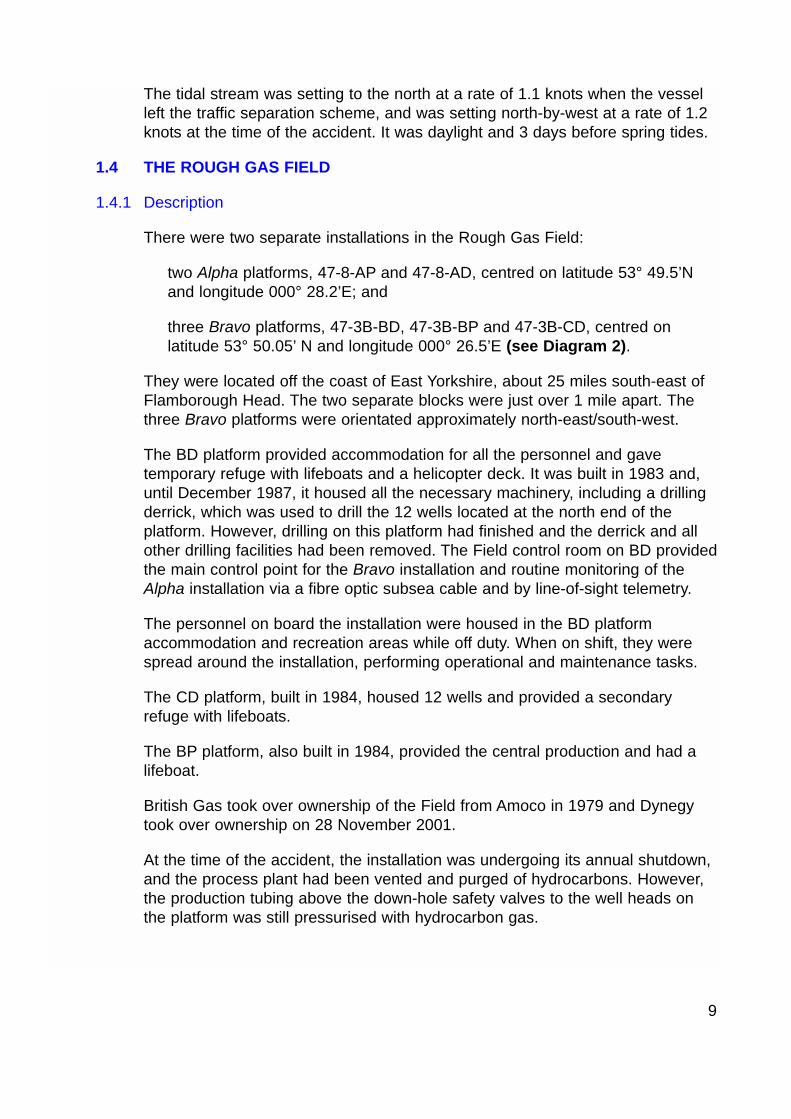
There were two separate installations in the Rough Gas Field:
two Alpha platforms, 47-8-AP and 47-8-AD, centred on latitude 53° 49.5’Nand longitude 000° 28.2’E; and
three Bravo platforms, 47-3B-BD, 47-3B-BP and 47-3B-CD, centred onlatitude 53° 50.05’ N and longitude 000° 26.5’E (see Diagram 2).
They were located off the coast of East Yorkshire, about 25 miles south-east ofFlamborough Head. The two separate blocks were just over 1 mile apart. Thethree Bravo platforms were orientated approximately north-east/south-west.
The BD platform provided accommodation for all the personnel and gavetemporary refuge with lifeboats and a helicopter deck. It was built in 1983 and,until December 1987, it housed all the necessary machinery, including a drillingderrick, which was used to drill the 12 wells located at the north end of theplatform. However, drilling on this platform had finished and the derrick and allother drilling facilities had been removed. The Field control room on BD providedthe main control point for the Bravo installation and routine monitoring of theAlpha installation via a fibre optic subsea cable and by line-of-sight telemetry.
The personnel on board the installation were housed in the BD platformaccommodation and recreation areas while off duty. When on shift, they werespread around the installation, performing operational and maintenance tasks.
The CD platform, built in 1984, housed 12 wells and provided a secondaryrefuge with lifeboats.
The BP platform, also built in 1984, provided the central production and had alifeboat.
British Gas took over ownership of the Field from Amoco in 1979 and Dynegytook over ownership on 28 November 2001.
At the time of the accident, the installation was undergoing its annual shutdown,and the process plant had been vented and purged of hydrocarbons. However,the production tubing above the down-hole safety valves to the well heads onthe platform was still pressurised with hydrocarbon gas.
10
Diagram showing the layout of the Bravo platform
Diagram 2

11
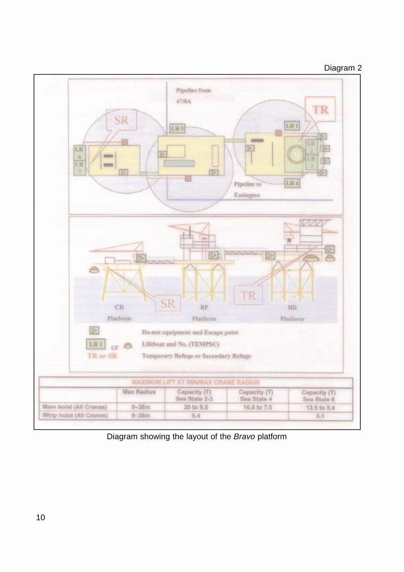
1.4.2 Damage (see Photographs 2 and 3)
Marbella struck the south-west corner of the BD jacket in the vicinity of leg B4and caused the following damage:
destruction of the two barge fenders and some other B4 leg appendages;
superficial damage to the B4 leg; and
damage to some secondary steelwork forming part of a navigational-aidplatform located just above the point of collision.
The structural integrity of the jacket was assessed using information from threesources:
the support vessel Kommander Subsea above and below water (the latter byROV deployed from the vessel);
results from a series of redundancy and impact analyses of BD jacket toexplore possible damage scenarios; and
offshore inspection of the topsides and above water jacket elements,undertaken once it was considered safe to re-man the installation.
The overall conclusion from the assessments was that the jacket was robust andthat structural integrity of the installation had not been unduly affected. Apartfrom a minor dent to a brace member, no damage to the primary structure wasevident and the damage was limited to the leg appendages.
1.5 MARBELLA
1.5.1 The vessel
Marbella (ex: Shetland Challenger, Norvestor, Klara Birting, Longva II) was astern freezer trawler and was ice-strengthened. She had a full-length shelterdeck, freezing equipment and a refrigerated hold. The vessel was built forShetland Island owners but was sold to Canadian interests in 1990. The vesselwas purchased from Norwegian owners in 1995 by the present owner (under themanagement of Marr Fishing Vessel Management Limited) and brought backinto the UK registry and renamed Marbella.
Her UK Fishing Vessel certificate was valid until 16 March 2004.
12 Close view of damage to BD jacket
Photograph 2
General view of damage to BD jacket
Photograph 3

1.5.2 The crew
There were 21 crew members on board at the time of the accident, consisting ofthe skipper, mate, second mate, bosun, cook, three engineers, nine spare handsand three learner deckhands. Most of them originated from the Hull area, whileseveral were from Grimsby and one of the engineers was from Cape Town inSouth Africa.
The second mate had had his 53rd birthday the day before the accident. He firstwent to sea in 1964, sailing as galley-boy on side-trawlers out of Hull. Heprogressed to learner deckhand and then to spare hand. He served on thesevessels until about 1978 when they were decommissioned. He moved tofreezer-trawlers fishing for mackerel off Rockall, and served as deckhand andthen as bosun. In 1984 he joined Marr Fishing Vessel Management Limited andserved as deckhand on stern trawlers and, in 1986, was promoted to bosun. Inthe mid-90s he was promoted to first mate and he had served for one trip onMarbella about 4 years before the accident. This was his first trip back on thevessel.
He had passed the Second Hand Full Certificate of Competency in 1975. Beforesubmitting his papers to the Registrar-General of Shipping and Seamen (nowRegistry of Shipping and Seamen) in Cardiff for his actual certificate, he had apersonal accident while fishing, in which he suffered severe head injuries andthe loss of sight to his right eye. Once he had recovered, he did not submit hispapers, in the belief that the certificate would not be granted to him because ofthe loss of the sight in his right eye. However, in 1993, Marr Fishing VesselManagement Limited required him to produce his certificate as part of a generalaudit. As a result, he applied for the certificate from the examination branch ofthe Marine Safety Agency (now Maritime and Coastguard Agency). The actualcertificate was issued to him in April 1993. The Fishing Vessels (Certification ofDeck Officers and Engineers Officers) Regulations 1984 do not requirefishermen to have regular medical examinations and they only need an eyesighttest when applying as a candidate for a Fishing Vessel Certificate ofCompetency, Deck Department. Merchant Shipping Notice MSN 1746(M) states:
…monocular serving seafarers and those who become monocular in serviceand meet the required standard should be allowed to continue at sea.
In an eyesight test performed since the collision, the second mate’s near anddistance vision for his left eye was found to be normal and, therefore, “met therequired standard”.
The skipper was 43 years old and had been at sea since 1975 serving on sidetrawlers, stern trawlers and freezer-trawlers. He was issued with his Deck OfficerCertificate of Competency (Fishing Vessel) Class 1 in July 1992 and waspromoted to skipper in the same year. He had served on Marbella for about 5years; one year as mate and four years as skipper.
13

14
1.5.3 Navigational equipment, practices, instructions and guidelines
The vessel’s navigational equipment included the following:
Anschultz Standard 14 gyro compass
Anschultz Nautopilot 14 automatic pilot
Furuno FR2110 radar
Furuno FR1510 Mk 3 radar
Furuno GP 500 Mk II GPS (console)
Furuno GP 50 Mk II GPS (chart table)
Shipmate 4000C navigation system
Shipmate 2500 colour video plotter.
There was no written voyage plan and only Admiralty charts 107 (Approaches tothe River Humber) and 1190 (Flamborough Head to Blakeney Point) hadcourses drawn on them. On the latter chart, the course line was drawn such thatit passed through the Bravo installation’s 500m zone (see Section 2.2.3). It wasthe practice to plot the position of the vessel every hour. Annex 24 VoyagePlanning to IMO Resolution A.893(21) (see Section 2.2.3) states:
Investigations show that human error contributes to 80% of navigationalaccidents and that in many cases essential information that could haveprevented the accident was available to but not used by those responsiblefor the navigation of the vessels concerned. Most accidents happen becausesimple mistakes in use of navigational equipment and interpretation ofavailable information, rather than because of any deficiency in basicnavigational skills or ability to use the equipment.
Masters, skippers and watchkeepers should therefore adhere to the IMOGuidelines taking the following measures to ensure that they appreciate andreduce the risks to which they are exposed:
a) ensure that the vessel’s navigation is planned in adequate detail withcontingency plans where appropriate;
b) ensure that there is a systematic bridge organisation that provides for:
i) comprehensive briefing of all concerned with the navigation ofthe vessel;
ii) close and continuous monitoring of the vessel’s positionensuring as far as possible that different methods of determiningthe position are used to check against error in any one system;

15
iii) cross-checking of individual human decisions so that errors canbe detected and corrected as early as possible;
iv) information available from plots of other traffic is used carefullyto ensure against over-confidence, bearing in mind that othervessels may alter course and/or speed;
c) ensure that optimum and systematic use is made of all appropriateinformation that becomes available to the navigational staff; and
d) ensuring that the intentions of a pilot are fully understood andacceptable to the vessel’s navigational staff.
The above resolution did not come into force until 1 July 2002. However, theMGN 84 (F) Keeping a Safe Navigational Watch on Fishing Vessels was “inforce” at the time of the accident and contained the following relevantinformation:
The watch should always take into account the prevailing circumstances andconditions. Even where there is no statutory requirement for certificatedofficers, it is still essential that watchkeepers are always experienced,capable, and have been instructed in their duties. This is especially vital ifyou are making landfall, navigating close to the coast, in restricted visibility,severe weather conditions or in dense traffic.
Both the skipper and the watchkeepers should take full account of the qualityand quantity of rest taken when determining fitness for duty.
The intended voyage should be planned in advance taking into account anyrelevant information. Courses should be checked before departure.
It is important that watchkeepers maintain a close watch on their vessel andalways know the position, speed and course steered.
The watchkeeper should know the location and operation of all safety andnavigational equipment on board and their limitations.
The company’s Vessel Operations Manual had a whole chapter dedicated tovoyage planning, giving an overview and instructions relating to responsibilities,electronic navigation systems, ocean waters, coastal waters, pilotage, ship’srouteing, ship reporting systems, and VTS. The following are relevant extracts:
Passage planning is necessary to support the bridge team and ensure thatthe ship can be navigated safely between fishing grounds and ports fromberth to berth. The passage plan should cover ocean, coastal and pilotagewaters.
The passage plan should aim to establish the most favourable route whilemaintaining appropriate margins of safety and safe passing distancesoffshore.
16
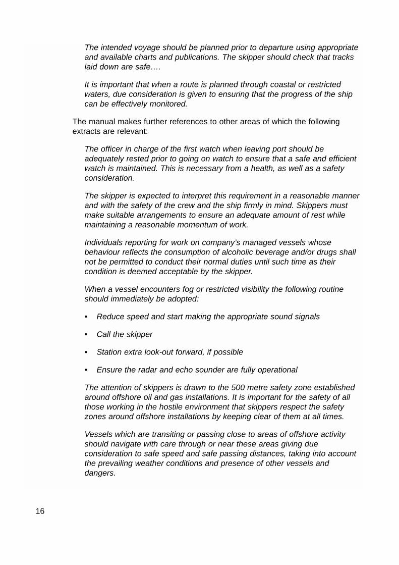
The intended voyage should be planned prior to departure using appropriateand available charts and publications. The skipper should check that trackslaid down are safe….
It is important that when a route is planned through coastal or restrictedwaters, due consideration is given to ensuring that the progress of the shipcan be effectively monitored.
The manual makes further references to other areas of which the followingextracts are relevant:
The officer in charge of the first watch when leaving port should beadequately rested prior to going on watch to ensure that a safe and efficientwatch is maintained. This is necessary from a health, as well as a safetyconsideration.
The skipper is expected to interpret this requirement in a reasonable mannerand with the safety of the crew and the ship firmly in mind. Skippers mustmake suitable arrangements to ensure an adequate amount of rest whilemaintaining a reasonable momentum of work.
Individuals reporting for work on company’s managed vessels whosebehaviour reflects the consumption of alcoholic beverage and/or drugs shallnot be permitted to conduct their normal duties until such time as theircondition is deemed acceptable by the skipper.
When a vessel encounters fog or restricted visibility the following routineshould immediately be adopted:
• Reduce speed and start making the appropriate sound signals
• Call the skipper
• Station extra look-out forward, if possible
• Ensure the radar and echo sounder are fully operational
The attention of skippers is drawn to the 500 metre safety zone establishedaround offshore oil and gas installations. It is important for the safety of allthose working in the hostile environment that skippers respect the safetyzones around offshore installations by keeping clear of them at all times.
Vessels which are transiting or passing close to areas of offshore activityshould navigate with care through or near these areas giving dueconsideration to safe speed and safe passing distances, taking into accountthe prevailing weather conditions and presence of other vessels anddangers.

1.5.4 Damage (see Photograph 4)
Marbella suffered substantial damage to the starboard bow, especially in way ofthe hospital and the first two-man cabin, both of which were on the shelter deck.Damage was also sustained to the masts and aerials on the accommodationsuperstructure and the after gantry.
1.6 PUTFORD ACHILLES
1.6.1 The vessel
Putford Achilles was a stand-by safety vessel for offshore oil and gasinstallations. She was built in 1973 in Canada as a conventional deck cargotug/supply vessel, and had two controllable pitch propellers and a bow thruster.She was owned by Putford Enterprises Limited of Lowestoft, and had a multi-functional role, in that she also supplied cargo to the installation fromImmingham, on average, every 9 days.
17
Damage to starboard bow of Marbella
Photograph 4

1.6.2 The master
The master was 54 years old and began his sea-going career when he leftschool. He originally went to sea on fishing vessels from Grimsby and attainedhis skipper’s full certificate of competency when he was 21. He continued deepwater fishing until 1976, when he bought his own fishing vessel and went pair-trawling in the North Sea. In 1980, he sold the vessel and joined Tidewater,serving on offshore oil industry supply and survey vessels. In 1983, he gained acommand endorsement for stand-by vessels. He served with several companiesuntil he joined Putford about 10 years before the accident, and he had served onPutford Achilles as master since then.
1.6.3 Navigational and communication equipment
The vessel’s navigational and communication equipment included the following:
Two Furuno GPS sets
One Sperry gyro
One Sperry automatic pilot
Three Furuno radars
Three VHF radio sets; two Sailor and one Furuno DSC
One Furuno MF/HF radio
One ICS Navtex
One Dittel helicopter radio
1.6.4 Relevant extracts from Dynegy’s instructions to stand-by vessels and foremergencies
Duty
To monitor using their ARPA potential ship collision and try to alert or divertvessel if impact is probable.
To inform the platform of any incident and assist in:
Reporting the nature, location and extent of the incident
Rescue of personnel from the sea
Application of water for cooling
Medical back up
Co-ordination of abandonment.
18

Vessel impact 47/3B
In all potential vessel impact situations, close liaison with the stand-by vesselshould be maintained to discover the errant vessel tonnage, location, speed andpredicted time of collision. As a guide, the following combinations of tonnageand speed will cause total jacket collapse:
47/3B
• 100,000 tonnes (eg a large crude oil tanker) at 1 knot
• 6,000 tonnes (eg a small coaster or very large supply boat) at 4 knots.
If impact looks probable, the platform should be shut down and vented.Personnel may be evacuated or moved onto another jacket eg CD. If longperiods of time are available helicopter evacuation may be considered.
Use of the general alarm should be used to alert personnel. Personnel may bedirected to muster at a single alternative muster point outside the TemporaryRefuge by a public announcement. The announcement should take place assoon as possible to avoid confusion.
The choice of alternative muster location is at the discretion of the OIM, but itshould be close to one of the installation bridges. This is to allow personnel totransfer at short notice to the platform least likely to be hit by the vessel.
1.6.5 Extracts from Putford’s operating procedures
Infringements of the safety zone
The OOW shall attempt to contact any vessel coming within 5 nautical miles, or20 minutes steaming if this is further, of a manned installation with a CPA of 500metres or less. If no satisfactory contact is established and before the intruderreaches a point 15 minutes from the installation the OOW shall:
• Call master
• Inform installation
• Switch on bridge tape recorder and log the time of doing so
• Continue efforts to contact intruder
• Put FRC crew on stand-by
• Move ship to intercept, if not engaged on a close stand-by task
• If on close stand-by, request permission to launch FRC and leave presentposition
19

• Close the intruder at best possible speed
• Continue to try and contact intruder
If there is still no response from the intruding vessel and no later than 15minutes from the potential collision:
• Launch FRC or Daughter craft (weather permitting) to intercept, attractattention and obtain full details of intruding vessel.
• Inform OIM of possible collision in 15 minutes (in order to allow time tomuster the installation personnel)
• Get as close to intruding vessel as safely practicable
• Continue using all available means to contact (horn, lights, flares etc.).
If after using all available methods the intruding vessel has not changed courseand a collision with the platform is inevitable:
• Advise OIM and decide action to be taken
• Advise Coastguard
• Make ship ready to receive survivors from the water
• Move the ship into safe position from which to effect a rescue bearing inmind tidal flow, wind direction and the likelihood of fire, both on the platformand the ship that collided with it
• Inform local platforms and stand-by vessels of the situation
• Inform the duty manager – via the T/R ship if necessary.
1.7 ACTION SINCE TAKEN BY THE MARITIME AND COASTGUARD AGENCY(MCA)
The MCA has initiated discussions with the offshore and fishing industries, withthe aim of reducing the number of future similar incidents and near misses. Thediscussions have focussed primarily on communication, with the intention offormulating a best practice guide, and a Safety Alert has been published(Annex).
20

SECTON 2 - ANALYSIS
2.1 AIM
The purpose of the analysis is to determine the contributory causes andcircumstances of the accident as a basis for making recommendations toprevent similar accidents occurring in the future.
The analysis focuses primarily on the actions taken by the watchkeepers ofMarbella and Putford Achilles during the period leading up to the collision, andtheir relevance to existing company operating instructions and procedures.
2.2 THE COLLISION
2.2.1 Sources of information and its analysis
Other than from Marbella’s personnel, there were four sources of informationgiving the track of the vessel. The sources were:
1. Amethyst Gas Field radar;
2. Humber VTS radar;
3. Putford Achilles’ radar plot; and
4. DEFRA’s recorded position for Marbella at 0934.
The first source was a platform-mounted radar system, which tracked andrecorded the movement of vessels within 25 miles of the Amethyst Gas Fieldinstallation (see Section 2.3.2).
This system tracked Marbella in the new traffic separation scheme in the north-eastern approaches to the River Humber, past the N New Sands buoy and up to7.5 cables from the BD platform, when the target was dropped from the system.
The Humber VTS radar tracked Marbella through the traffic separation scheme,past the N New Sands buoy and then up to about 3.2 miles from the BDplatform.
The master of Putford Achilles made three plots of Marbella, starting when thelatter was 3.15 miles from the BD platform until she was 1.15 miles away.
The first two sources agree that, from the N New Sands buoy Marbella wasmaking good a course over the ground of 011° (+/- 0.5°) and an average speedof about 13.1 knots. The first three predicted that Marbella would pass to thewest of the installation; either tangential to the 500m zone (Amethyst) or throughthe zone (VTS Humber and Putford Achilles).
21

However, the Amethyst radar plot from the penultimate position (0930 – 1.1miles from BD platform) to the last position (0932 – 0.75 miles from BD platform)shows a course 12° to starboard of that made good up to that point (seeDiagram 3). The alteration was from a course which would pass the installationto starboard, to one which would collide with it. This is confirmed by Marbella’sautomatically transmitted 2-hourly GPS position to DEFRA at 0934. The positionwas latitude 53° 49.66’N longitude 000° 26.19’E, which placed her 3.2 cablesaway from BD platform, just outside the 500m zone and in line with the previoustwo Amethyst positions.
2.2.2 Second mate’s actions
The reason for the alteration of course at about 0930 has not been identified.The second mate’s recollection is that he did not alter the automatic steeringuntil he attempted to avoid the platform at close quarters. Either before or afterthe accident, there was no report of any mechanical malfunction of the steeringgear, gyro or automatic pilot. There was no traffic in the area for the secondofficer to avoid.
The second mate had placed the EBL on what he thought was the Bravoinstallation, which gave a bearing of 022°. However, from the tracks taken fromVTS Humber and Amethyst, the Bravo installation would have been right aheadat about 0913 (see Diagram 4). The Alpha installation would have been bearing022° at about 0903. At no time during the incident was the Bravo installationbearing 022°. Although the second mate knew the difference in radar echo sizesbetween the Alpha and Bravo installations, the latter of which is the larger of thetwo, he seems not to have seen or have identified the echo ahead of him. Thissituation was not helped by not plotting the position of the vessel in relation tothe installation at regular intervals, and he did not use the ARPA system.Therefore, he had not properly identified the two installations and the movementof the vessel in relation to them. The lack of monitoring was due, in part, to theprocedure on board of only plotting the position of the vessel at hourly intervals(see Section 1.5.3). He had attended a radar observer course but not onedealing with ARPA.
To the second mate’s recollection, he had not been on watch after having justleft the River Humber for about 4 years. The traffic separation scheme to theapproaches to the River Humber was implemented in June 2001. Whereas inthe past the vessel would have turned to the north for Norway when clear ofshallow patches at S Binks buoy, she did not do so until she was past the NNew Sands buoy, which is about 2.5 miles further to the east. As for many yearsin the past, the vessel used the same course of 015° from N New Sands buoyas from S Binks buoy. On the latter track, the bearing of the Bravo installation,when on the edge of the 12-mile radar range scale, is 022°. Therefore, thesecond mate’s account of the events might have been confused with hisprevious experience of keeping a watch in the approach to the Rough Gas Field.
22

23
0900
0906
0912
0918
0924
0930
0932Last Amethystradar position
0934
DEFRAGPSposition
Track of Marbellafrom Amethyst fieldradar
Trac
k of
Marb
ella
from
Am
ethy
st fi
eld
rada
r
Diagram 3

24
Track ofMarbella
0934
0842
0848
0854
0900
0906
0912
0918
0924
0930 0932
Reproduced from Admiralty Chart 1190 by permission ofthe Controller of HMSO and the UK Hydrographic Office
Bearing022°
Bearing022°
Course015°
Course015°
12 miles
12 miles fromBravo installation
Previous plannedcourse of 015º Actual heading
Trac
ks ta
ken
from
VTS
Hum
ber a
nd A
met
hyst
rada
rs
Diagram 4

The second mate’s interpretation was that the echo of the installation was lost inthe clutter, when the radar was on the 3-mile range scale. However, the seastate was not rough enough to produce excessive clutter to hide the large echoof the installation. When he had reduced the range scale, he did not adjust anyof the controls such as gain, clutter and tuning. It may have been that thesecontrols had not been set up properly, and when the vessel neared theinstallation, the echo was lost near the centre of the screen. However, allwitness evidence suggests that the radar controls were set appropriately.
In accordance with the company’s instructions, when the visibility reduced, thesecond mate should have called the skipper, reduced speed and started tomake sound signals (see Section 1.5.3). A reduction in speed would haveallowed more time in which to take avoiding action.
The second mate’s actions and non-actions might have been affected byseveral personal factors. It had been his birthday the day before the accident, incelebration of which he had consumed an amount of alcohol in the afternoonand a meal at about 1930. He had gone to bed at about 2130 and had arisen at0130 to join Marbella. The combination of alcohol, food, and a short sleepperiod possibly had some adverse effect on his initial state of alertness.Although he might have recovered, to some extent, by being on deck for severalhours, as the day progressed during his watch, his state of alertness wouldpossibly have degraded again through lack of rest. Because the joining timewas in the early hours of the morning, it would have been wise if, before thevessel sailed, having identified who was to take the first watch, the second matehad been informed immediately and instructed to get some sleep without beingrequired for further duties in the river. The skipper would then have been moreassured that the first watchkeeper would be adequately rested before takingover the watch (see Section 1.5.3).
In an eyesight test performed since the accident, the second mate’s near anddistance vision for his left eye was found to be normal. In this case, because ofthe presence of a lookout and normal vision in his left eye, it is concluded thatthe fact that the second mate had vision in one eye only, had no bearing on thecauses of the accident.
2.2.3 Voyage planning
There was little evidence that a satisfactory voyage plan had been made byeither the skipper or the mate for the passage from Hull to the fishing grounds inthe Arctic Circle, despite extensive information and advice in the company’sVessel Operations Manual.
Originally, Marbella’s track was drawn on the paper chart through Bravo’s 500msafety zone. It has been a practice with fishing vessels that, when on passageto and from the fishing grounds, courses are drawn (either electronically or onpaper charts) through offshore oil/gas fields, rather than to planned waypointseither side of them. It is the general rule that, when a fishing vessel encountersan installation, the watchkeeper alters course around the 500m zone.
25

IMO Resolution A.893(21) (see Section 1.5.3) came in to force on 1 July 2002where voyage planning is required on all vessels (including fishing vessels)which proceed to sea. Although the resolution did not apply at the time of theaccident, voyage planning has been in practice for many years. Had voyageplanning been implemented on Marbella, and better navigational practicesobserved (under the guidance of MGN 84) regular monitoring of the vessel’sposition and the use of waypoints to keep clear of installations, may have helpedto prevent the accident (see Section 1.5.3).
2.3 COLLISION PREVENTION
2.3.1 Putford Achilles
The main purposes, among others, of a stand-by vessel, is to guard againstpassing vessels entering the 500m safety zone and colliding with the installation.Photograph 5 shows recorded tracks of acquired echoes from Putford Achilles’ARPA. There are distinct tracks of vessels travelling to and from FlamboroughHead, to and from the Baltic and the movement of fishing vessels in and aroundthe Rough Gas Field.
The seabed around the Rough Gas Field is suitable for potting and these type offishing vessels can travel at speed when approaching the area. Putford Achilleshad a list of 20 fishing vessels, which operated in the area. Only one was over12m in length and some had a high engine power, giving likely speeds of up to25 knots. It had become commonplace in reasonable visibility for the stand-byvessel’s watchkeepers to take no action to intercept these vessels after they hadbeen identified and been seen to be approaching the gas field.
At the time of the accident, the master had chosen not to use the radar guardzone because of the fishing vessel activity in the area. However, he had notedthe movement of Marbella’s echo from about 12 miles away. He thought thiswas yet another fishing vessel closing the Rough Gas Field and would stop atsome time and begin fishing. However, he was sufficiently concerned that hemanually plotted the echo when it was 3.15 miles and about 15 minutes away(the ARPA had been dropping targets from the screen) and made the third plotwhen the vessel was 1.15 miles and about 5 minutes before the collision, theresults of which showed that the vessel would pass to the west of the installation(see Section 2.2.1). However, in accordance with Putford’s operatingprocedures, the plots should have been completed when the vessel was 15minutes away from the installation so that the master could give the requirednotice to the OIM in the case of a potential collision and personnel could bemustered (see Section 1.6.5). Between the plots, the master tried to callMarbella on VHF radio channels 16 and 72 but without response. Had themaster made contact with Marbella, it would have alerted the second mate thathe was going to pass too close to the installation, and he would probably havealtered course to give a much larger passing distance. The master’s plot showedthat the other vessel would pass through the 500m zone and close to the
26

27 Recorded vessel tracks from Putford Achilles ARPA
Photograph 5

installation; it was not on a collision course at the time of completing the plots;this happened a little later. Therefore, the master was dealing with a potentialinfringement of the safety zone and not with a collision scenario, which, togetherwith his uncertainty as to whether or not the fishing vessel was going to stop andstart fishing, is apparently why he did not intercept the vessel or inform the OIMof the situation. This was a breach of Putford’s operating procedures (seeSection 1.6.5). In practice, given the number of fishing vessels fishing in thearea on a regular basis, by following the procedures, the installation would havebeen alerted frequently and, on most occasions, unnecessarily. The master hadpreviously ignored his company’s operating procedures when he could identifythe approaching vessel. On this occasion, however, he was unable to identifythe vessel and failed to take this factor into account in assuming she would stopand start fishing without endangering the platform. His previous routineviolation of the company’s operating procedures probably made this failure allthe more likely. The initiative since taken by the MCA should contribute topreventing stand-by vessel watchkeepers from assuming that known fishingvessels will stop and start fishing, and encourage compliance with existingcompany operating procedures.
The master believed that it would be difficult to go round the installation tointercept the approaching vessel because, as his vessel travelled nearer to theinstallation, its echo would arc on the radar screen and he would, therefore,have difficulty in keeping clear of it. However, if he had taken earlier action, inaccordance with Putford’s operating procedures, this problem could have beenavoided.
The master was using a slave VHF radio handset near the radars. The masterset was at the after end of the wheelhouse. When Marbella made her “Pan Pan”broadcast, the master heard it on the DSC VHF radio set, which he used to callMarbella in response. It was later found that the after master VHF radio handsethad not been fully depressed because a faulty spring clip did not allow a microswitch to operate correctly. Because the micro-switch had not been operated,the slave handset was not active and the previous calls to Marbella were notbroadcast. New clips have now been supplied to the vessel, and a warningnotice has been posted to ensure that the handset is fully depressed to be ableto operate the slave handset.
2.3.2 Installation-based radar
The fixed radar system, located on the BP operated Amethyst offshoreinstallation to the south-east of the Rough Gas Field, was designed to givewarning of approaching vessels to the Amethyst installation. Its ability to processthe movements of numerous vessels is more sophisticated than the usualmarine radars used on vessels. The data from the radar and computerprocessing system can be transmitted to the installation’s command and controldisplay, and to the field’s stand-by vessel display, and, using an electronic
28

Admiralty chart, provide collision and other defined warnings to watchkeepers. Itcan guard not only the platform on which it is mounted, but also other satelliteplatforms; a task which would be onerous for one watchkeeper on a stand-byvessel. The automatic alarm system for approaching vessels which have a zeroCPA for any of the platforms in the field, can be changed to a time basis,depending on the speed of the vessel, giving different stages of alertness. Nothaving to plot approaching vessels gives more time for the stand-by vesselpersonnel to decide what action needs to be taken. The control room of aninstallation is also alerted by the system instead of solely by the stand-byvessel. The system can also differentiate precipitation from that of a movingecho of a vessel, and suppress only the area of the precipitation, and not thewhole radar picture. Because the radar scanner is large, mounted high up andon a static installation, the radar range is greater and more accurate in itsprediction of the movement of an echo. The Amethyst-based radar is operatingat the limits of its capabilities to cover the Rough Gas Field installations.
29

SECTION 3 - CONCLUSIONS
3.1 CAUSAL FACTORS
1. An unexplained alteration of course, from one that would have passed theinstallation to starboard side of the vessel, to one which was on a collisioncourse with the installation. [2.2.2]
2. Little evidence of a satisfactory voyage plan. Marbella had been set originally ona course that would take her too close to the installation. Had a satisfactoryvoyage planning been implemented, with proper tracks clear of installations, itcould have helped in preventing the accident. [2.2.3]
3. The second mate had not properly identified the two installations, because ofpoor monitoring, the radar’s heading line, his previous experience, the practiceof one-hour position plotting, and the movement of the vessel in relation to them.[2.2.2]
4. Marbella’s radar controls might not have been set up properly, and when thevessel neared the installation, its echo might have been lost near the centre ofthe screen. However, all witness evidence suggests that the radar controls wereset appropriately. [2.2.2]
5. When the visibility reduced, the second mate did not call the skipper or reducespeed, contrary to the company’s instructions. A reduction in speed would haveallowed more time in which to take avoiding action. [2.2]
6. It would have been wise if, before the vessel sailed, having identified who was totake the first watch, the second mate had been informed immediately andinstructed to get some sleep without being required for further duties in the river.The skipper would then have been more assured that the first watchkeeperwould be adequately rested before taking over the watch. [2.2.2]
7. Putford Achilles’ master did not intercept or warn the OIM of the approachingvessel, which was a breach of Putford’s operating procedures. [2.3.1]
8. Putford Achilles’ master was dealing with a potential infringement of the safetyzone and not with an impact scenario, which together with his uncertainty as towhether or not the fishing vessel was going to stop and start fishing, isapparently why he did not inform the OIM of the situation. From pastexperience, when he could identify local fishing vessels which operated in thearea, he routinely ignored his company’s operating procedures for potentialinfringements of the safety zone. A difference on this occasion was that he wasunable to identify the approaching vessel, and failed to take this factor intoaccount in assuming she would stop and start fishing without endangering theplatform. His previous routine violation of the company’s operating proceduresprobably made this failure all the more likely. [1.2.2, 2.3.1]
30

9. If Putford Achilles’ master had verbally contacted Marbella, it would have alertedthe second mate that he was going to pass too close to the installation and hewould probably have altered course to give a much larger passing distance.Verbal contact was unknowingly prevented by faulty VHF radio equipment.[2.3.1]
3.2 OTHER FINDINGS
1. Had Marbella run full speed directly under the BD platform and into her crosssupporting members, there was a high possibility that the platform might havecollapsed, endangering the lives of those personnel that were on it at the time.[2.2.2]
2. Marbella would have passed to the west of the installation had she remained onher original track. [2.2.1]
3. The reason for the alteration of course at about 0930 has not been identified.[2.2.2]
4. The combination of alcohol, food, and a short sleep period possibly had someadverse effect on the second mate’s initial state of alertness, which possiblydegraded through lack of rest as the day progressed. [2.2.2]
5. The fact that the second mate had vision in only one eye had no bearing on thecauses of the accident. [2.2.2]
6. The fault with Putford Achilles’ VHF radio set has since been rectified. [2.3.1]
7. An installation-based radar may greatly help in monitoring the approach ofvessels to an installation. [2.3.2]
8. The initiative since taken by the MCA should contribute to preventing stand-byvessel watchkeepers from assuming that known fishing vessels will stop andstart fishing, and encourage compliance with existing company operatingprocedures. [2.3.1]
31

SECTION 4 - ACTION TAKEN
The MCA has initiated discussions with the offshore and fishing industries, with the aimof reducing the number of future similar incidents and near misses. The discussionshave focussed primarily on communication, with the intention of formulating a bestpractice guide. This should contribute to preventing stand-by vessels from assumingthat known vessels will stop and start fishing, and encourage compliance with existingcompany operating procedures.
In March 2003, the MCA issued a Safety Alert to be circulated throughout the industry(see Annex).
A Chief Inspector’s letter has been sent to Boston Putford Safety Ltd, recommendingthe company to:
• Reinforce its operating procedures with respect to potential infringements of thesafety zone; and
• Ensure, through effective auditing, that its operating procedures are being compliedwith.
A Chief Inspector’s letter has also been sent to Marr Fishing Vessel ManagementLimited, recommending the company to:
• Review its Vessel Operations Manual with respect to passage planning andmonitoring, and provide additional specific instructions to ensure that:
- Charted courselines pass clear of the 500m safety zone of offshore installations;and
- Positions are regularly and frequently fixed on the chart in use; and
• Ensure, through effective auditing, that its instructions are being complied with.
Marine Accident Investigation BranchSeptember 2003
32

ANNEX
MCA Safety Alert