Embed Size (px)
Citation preview
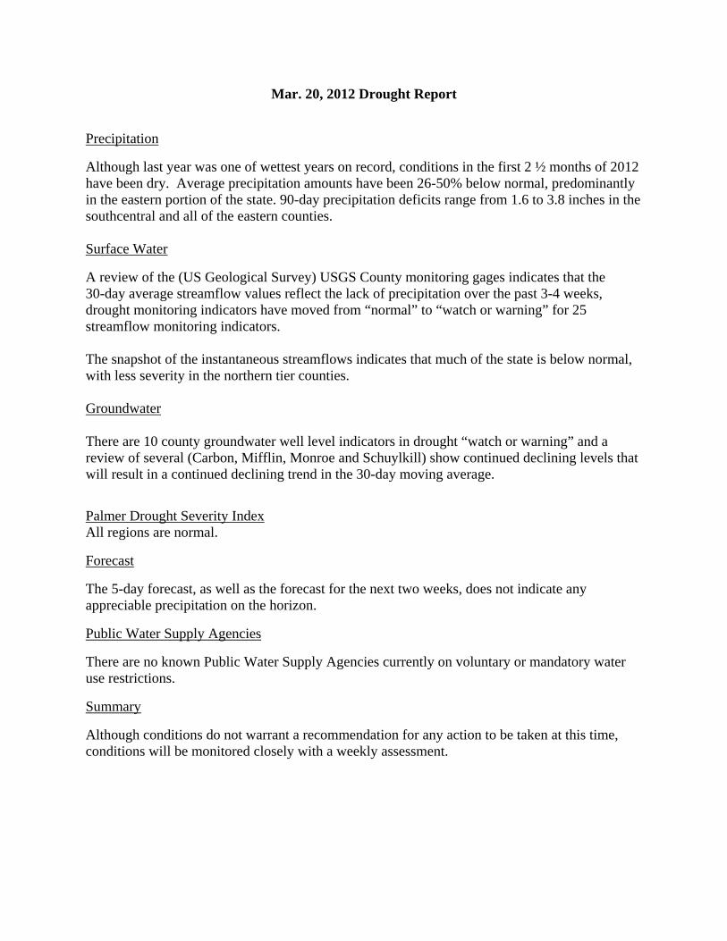
Mar. 20, 2012 Drought Report
Precipitation
Although last year was one of wettest years on record, conditions in the first 2 ½ months of 2012 have been dry. Average precipitation amounts have been 26-50% below normal, predominantly in the eastern portion of the state. 90-day precipitation deficits range from 1.6 to 3.8 inches in the southcentral and all of the eastern counties. Surface Water
A review of the (US Geological Survey) USGS County monitoring gages indicates that the 30-day average streamflow values reflect the lack of precipitation over the past 3-4 weeks, drought monitoring indicators have moved from “normal” to “watch or warning” for 25 streamflow monitoring indicators. The snapshot of the instantaneous streamflows indicates that much of the state is below normal, with less severity in the northern tier counties. Groundwater
There are 10 county groundwater well level indicators in drought “watch or warning” and a review of several (Carbon, Mifflin, Monroe and Schuylkill) show continued declining levels that will result in a continued declining trend in the 30-day moving average.
Palmer Drought Severity Index All regions are normal.
Forecast
The 5-day forecast, as well as the forecast for the next two weeks, does not indicate any appreciable precipitation on the horizon.
Public Water Supply Agencies
There are no known Public Water Supply Agencies currently on voluntary or mandatory water use restrictions.
Summary
Although conditions do not warrant a recommendation for any action to be taken at this time, conditions will be monitored closely with a weekly assessment.
April 02, 2012 Drought Report
Precipitation
Average precipitation amounts continue to be 26-50% below normal, predominantly in the eastern portion of the state with Monroe and Carbon Counties moving to 51-75% below normal status. 90-day precipitation deficits ranges have increased from two weeks ago from 1.6 to 3.8 inches to 1.9 to 5.5 inches in the southcentral and all of the eastern counties. Surface Water
A review of instantaneous streamflows indicates that current flows are below normal in the Upper Ohio Basin, most of the Susquehanna River Basin and the Middle Delaware Basin. The remaining areas reflect decreasing flows of various severities. Thirty nine percent of the gages have instantaneous flows at less than the 10th Percentile. The recent rainfall did very little to affect streamflow and therefore most gages continue to show a decline in flow. A review of the (US Geological Survey) USGS County monitoring gages indicates that the 30-day average streamflow values reflect the continued pattern of below normal rainfall across the state. There are now 9 counties in Emergency, 9 in Warning and 24 in Watch for a total of 42 counties in a drought status. The previous report of two weeks ago had 25 counties in either drought Watch or Warning, therefore a continued decline of 30-day average streamflows continues with the severest areas in the eastern part of the state. Overall, the 30-day average streamflow values are declining across the state with additional counties expected to cross into drought watch status and other expected to continue their decline. Groundwater
Groundwater 30-day moving average levels continue to decline in the eastern part of the state with four county groundwater well level indicators now in drought emergency status –Lackawanna, Pike, Monroe and Carbon. With lack of precipitation forecast, we would expect groundwater levels to continue to drop over the next week bringing additional county indicators in the east into drought watch, warning or emergency status.
Palmer Drought Severity Index All regions are normal.
Forecast
Forecasts for the next 5 to 7 days do not indicate any appreciable precipitation and amounts only between 1-inch to 1.5-inch between April 10 and April 18.
Public Water Supply Agencies
There are no known Public Water Supply Agencies currently on voluntary or mandatory water use restrictions.
Summary
Deteriorating precipitation, streamflow and groundwater conditions, as evidenced by ongoing monitoring across the Commonwealth, will likely continue. It is recommended that a Drought Task Force meeting be scheduled to meet in the next two weeks to discuss conditions.
April 09, 2012 Drought Report Precipitation
Very little precipitation fell across the state over the past week, with little to no precipitation falling in the west and only about 0.4 inches of precipitation in the east. Average precipitation amounts continue to be 26-50% below normal, predominantly in the eastern portion of the state. 90-day precipitation deficits persist in the -5.3 inch range in the Monroe/Carbon County area. Surface Water
Decreasing streamflow levels continued to expand westward over the past week. Instantaneous Streamflow information indicates that the current flows are under low flow conditions throughout the northeast across to the northwest with below normal conditions in the remaining area of the state. The trace levels of rainfall over the past week did very little to affect streamflow and therefore most gages continue to show a decline in flow. A review of the (US Geological Survey) USGS County monitoring gages indicates that the 30-day average streamflow values reflect the continued declining pattern as a result of below normal rainfall across the state. There are now 30 counties in “Emergency” (up from 9 last week), 10 in “Warning” (up from 9 last week) and 19 in “Watch” (down from 24 last week) for a total of 59 counties in a drought status (up from 42 last week). Overall, the 30-day average streamflow values are declining rapidly across the state with additional counties expected to cross into more severe levels of drought status. Groundwater
Groundwater 30-day moving average levels continue to decline through much of the eastern part of the state with several counties in the central and northern regions of the state declining as well.
There are now seven counties in drought “Emergency” status for groundwater–Lackawanna, Pike, Monroe, Carbon, Luzerne and Columbia. Unless significant precipitation occurs over the next few weeks, it is expected that groundwater levels will continue to drop indicating more severe levels of drought status.
Palmer Drought Severity Index All regions are normal.
Forecast
Precipitation forecasts over the next two weeks are not encouraging with ranges of 0.25 to 0.5 inches for the next five days and 1.0 to 1.5 inches cumulatively out to April 25, 2012. These amounts will not make up the deficits and the deficits will continue to increase.
Public Water Supply Agencies
There are no known Public Water Supply Agencies currently on voluntary or mandatory water use restrictions.
Summary
Deteriorating precipitation, streamflow and groundwater conditions, as evidenced by ongoing monitoring across the Commonwealth, will likely continue. It is recommended that a Drought Task Force meeting be scheduled to meet in the next two weeks to discuss conditions.
April 16, 2012 Drought Report Precipitation
Very little precipitation fell across the state over the past week, with little to no precipitation falling in most of the state and only about 0.5 inches of precipitation in the southwest corner. Average precipitation amounts continue to be 26-50% below normal and are moving to 51-75% below normal, predominantly in the eastern portion of the state. 90-day precipitation deficits persist and are now greater than or approaching 6.0 inches in the Monroe/Carbon County area. Surface Water
A review of instantaneous streamflows indicates that current flows are below normal across the state with a significant number, 80 of 183 reporting gages, at record lows for the day. Eighty-two percent of the gages have instantaneous flows at less than the 10th Percentile. Most gages continue to show a decline in flow. A review of the (US Geological Survey) USGS County monitoring gages indicates that the 30-day average streamflow values continue to fall across the state. There are now 42 counties in “Emergency”, up from 30 last week, 10 in “Warning” and 12 in “Watch” for a total of 64 counties in a drought status. The previous report had 59 counties in drought status. Overall, the 30-day average streamflow values continue to decline across the state. Several counties now have 30-day average streamflows at record lows with this pattern expected to continue through the week. Groundwater
The trend of declining Groundwater 30-day moving average levels continues for the eastern part of the state and several counties in the north-central and north-western part of the state. Of significance are those monitoring wells in counties previously indicating a “watch” status have now moved into “emergency” status – Mercer, Lawrence, McKean, Potter, Bradford, Wyoming, Sullivan. These counties join those which previously were in “emergency” status – Lackawana, Luzerne, Columbia, Schuylkill, Carbon, Monroe and Pike Counties for a total of 14 counties monitoring wells having “emergency” indicator status.
Palmer Drought Severity Index All regions are normal.
Forecast
Except for trace amounts in the northwest corner, no significant precipitation is forecast for most of the state over the next five days.
Although some precipitation amounts in the 1.0 to 1.5 inch range are forecast between April 24 and May 2, those amounts will not make a significant change in current precipitation deficits or likely not make much difference in groundwater levels with increasing evaporation and transpiration levels as temperatures rise and trees leaf out.
Public Water Supply Agencies
There are no known Public Water Supply Agencies currently on voluntary or mandatory water use restrictions.

Summary
Deteriorating precipitation, streamflow and groundwater conditions, as evidenced by ongoing monitoring across the Commonwealth, will likely continue. A Drought Task Force meeting has been scheduled for April 25 at 1:00 at PEMA to discuss conditions.
April 24, 2012 Drought Report Precipitation
A significant storm front moving along the eastern seaboard this past weekend provided accumulated
precipitation depths over the past seven days in the range of up to 2.0 to 2.5 inches in the Delaware and
Potomac Basins with 1.0 to 1.5 inches in the central and amounts of about 0.5 inches in the west.
With this precipitation, departures from normal over the past 90-days in the eastern half of the state have
diminished with now only five counties in the 51% to 75% below normal range – Monroe, Carbon,
Schuylkill, Columbia and Montour Counties. However, lesser depths of precipitation in the central and
western parts of the state have resulted in increased deficits. Since April 16, additional counties have
moved from the 25% below to average range into the 26% to 50% range. Total departure over the past
90-days now ranges from a low of -1.8 inches in Jefferson County to a high of -5.9 inches in Monroe
County.
Surface Water
A review of instantaneous streamflows indicates that current flows have improved as a result of
the rainfall which occurred over the past three days. However, there are still 4 gages reporting
record lows for the day with 14 percent of the gages having instantaneous flows at less than the
10th
Percentile. Instantaneous streamflow ranges are from above normal in the Delaware Basin to
below normal in the Susquehanna and Ohio Basins. Overall, streamflows have already begun to
drop with many falling back into below normal flows for the day.
A review of the (US Geological Survey) USGS County monitoring gages indicates that the
30-day average streamflow values continue to fall in the Ohio Basin. In the Susquehanna Basin
and Upper Delaware Basin the 30-day average flows are showing minor improvement with no
changes in status. In the Southeastern portion of the state, 30-day average flows have improved
with Montgomery and Philadelphia Counties moving from “Emergency” to “Watch” status,
Bucks County moving from “Emergency” to “Warning” Status, Chester and Delaware Counties
improving from “Warning” to “Watch” Status and Lehigh County moved from “Watch” to
“Normal” Status. There are now 44 counties in “Emergency”, up from 42 last week, 7 in
“Warning” and 14 in “Watch” for a total of 65 counties in a drought status. The previous report
had 64 counties in drought status. Overall, the 30-day average streamflow values continue to
decline across most of the Susquehanna and Ohio Basins with improvement shown in the
Delaware Basin although it is anticipated that the 30-day average flows will again begin to drop.
Several counties continue to have 30-day average streamflows at record lows.
Groundwater
Recent precipitation has had no affect on groundwater levels with continued declining Groundwater 30-
day moving average levels in most of the state. Since April 16, Mifflin and Centre counties moved into
“emergency” levels and several counties moved from “normal” status into “watch” – Susquehanna, Wayne, Fayette, and Somerset with Union County moving from “watch” to “warning” level.
At this time of year, with leafing out of trees and rising temperatures, evapo-transpiration levels typically
increase coincident with decrease groundwater infiltration rates.
Palmer Drought Severity Index
All regions are normal.
Forecast
The five-day NOAA forecast is showing cumulative precipitation depths expected through April 29th in
the range of 0.5 to 1.5 inches in the west and up to 0.5 inches in the east. The longer term forecast From
May 2nd
through May 10th calls for similar cumulative amounts of up to one inch across the state.
Public Water Supply Agencies
There are no known Public Water Supply Agencies currently on voluntary or mandatory water use
restrictions.
Summary
As a result of the precipitation over the past week, there has been a slight improvement for counties in the
southeastern corner of the state with precipitation deficits decreasing and 30-day average streamflow
values increasing. For the remainder of the state, however, precipitation deficits continue to build and 30-
day streamflow values and groundwater levels continue to decline. A Drought Task Force meeting has
been scheduled for April 25 at 1:00 at PEMA to discuss conditions.
Drought Task Force Meeting Update:
The Drought Task Force met on 4/25/12 to discuss current hydrologic conditions and drought
management activities. After presentations from the NWS and DEP and a fairly in-depth discussion of
the various drought parameters that are monitored, there was general consensus from the Task
Force to delay a drought watch declaration and meet again in three weeks to reassess conditions.
April 30, 2012 Drought Report Precipitation
The state received some precipitation over the past week, varying from very little (about 0.2 inches or
less) for a large portion of the southeast/southcentral part of the state including the western edge and up to
approximately 1 inch or greater for a handful of counties along the Allegheny Front. Departures from
normal over the past 90-days have continued to increase with the majority of the state falling between
26% and 75% below average with the exception of Jefferson and Indiana Counties that are in the 25%
below to average range.
As the lack of meaningful precipitation continues, longer-term precipitation departures (120 and 150 day
departures) are becoming more pronounced with indicators moving to “watch” and “warning” and even
“emergency” for six counties (Berks, Carbon, Delaware, Monroe, Montour and Schuylkill) for the 120-
day departure from normal.
Surface Water
A review of instantaneous streamflows indicates that current flows have returned to below normal flows
except in the Upper Susquehanna and Upper Ohio Basins. There are 2 gages reporting record lows for the
day with 14 percent of the gages having instantaneous flows at less than the 10th Percentile. Overall
streamflows have already begun to drop with most reflecting below normal conditions.
A review of the (US Geological Survey) USGS County monitoring gages indicates that the 30-day
average streamflow values have peaked and are falling across the state except in the Upper Ohio River
Basin. In the Southeastern portion of the state, Chester County moved from “Watch” to “Normal” status.
The following counties all saw changes in Drought Status: Erie County from “Emergency” to “Watch”;
Susquehanna, Westmoreland and Wyoming Counties from “Emergency” to “Warning”; Bucks County
from “Warning” to “Watch”; and Bedford County from “Watch” to “Warning”. There are now 40
counties in “Emergency”, down from 44 last week, 10 in “Warning” and 14 in “Watch” for a total of 64
counties in a drought status. The previous report had 65 counties in drought status. Overall, the 30-day
average streamflow values have resumed their decline across most of the Commonwealth with the only
exception being in the Upper Ohio Basin. Several counties continue to have 30-day average streamflows
at record lows.
Groundwater
Precipitation events over the past few weeks is finally showing up on groundwater indicators as slight
rises to the 30-day moving averages of a number of groundwater monitoring wells. However, many other
groundwater 30-day averages have not seen any rise and continued to decline. Overall, there is little improvement shown on the county level groundwater indicators.
Palmer Drought Severity Index
Prior to this week, all soil moisture indicators had been normal. This week several counties moved into
“watch” indicator status – Schuylkill, Carbon, Lehigh and Northampton (Region 2).
Forecast
NOAA forecasts show this week to have a good probability of precipitation across the state with depths
predicted today to range over the next five days from about 0.5 inches in the east to 2 inch depths in the
western part of the state. On a longer term, forecasts for May 8 through May 16 call for horizontal bands
of cumulative precipitation depths between 0.25 inches in the north up to 3 inches in the south.

Public Water Supply Agencies
There are no known Public Water Supply Agencies currently on voluntary or mandatory water use
restrictions.
Summary
Overall, conditions continue to decline for most areas of the Commonwealth despite the precipitation
from last week. Conditions will be monitored closely.
A Drought Task Force meeting has been scheduled for May 16 at 1:00 at PEMA to discuss conditions.
May 8, 2012 Drought Report Precipitation
A recent weekly pattern of modest precipitation continued this past week with some locations
accumulating depths of up to two inches of rain with most of the state receiving up to one inch. This past
week’s precipitation has reduced the 90-day departures up to about one inch in some eastern and northern
counties. In other areas, reduction on departures has been less due to lighter precipitation, but showed
improvements nonetheless.
Current precipitation departure statistics over the last 90-days show only Schuylkill County as having a
departure in the range of 51% to 75% of normal as compared with 15 counties in the that indicator last
week. While no county indicator has reached the “Average to 25% above” level, 11 counties are now
only in the “25% below to average” range.
Surface Water
A review of instantaneous streamflows indicates that current flows have returned to normal flows except
for portions of the lower Susquehanna and lower and middle Delaware Basins.
A review of the (US Geological Survey) USGS County monitoring gages indicates that 28 counties have
shown some improvement of the 30-day average streamflow values with drought indicators moving from
“Emergency/Warning/Watch” to “Warning/Watch/Normal”. There are now 22 counties in “Emergency”
(down from 40 last week), 16 counties in “Warning” (up from 10 last week), 21 counties in “Watch” (up
from 14 last week) and 8 counties have returned to normal.
Groundwater
The 30-day moving average indicators for groundwater have changed slightly from last, with six counties
declining (Cumberland, Fayette, Franklin, Montour, Somerset and Union) and four counties improving
(Erie, Lycoming, Northumberland and Snyder). A review of monitoring well depths reveals a pattern of
many wells in the north showing an increase in well depths as a result of recent precipitation events with
many wells in the southern half of the state showing lower depths or no change.
Currently there are 17 counties having “Emergency” groundwater indicators, five in ‘Warning” and 13 in “Watch”.
Palmer Drought Severity Index
All counties now show a Palmer Drought Index within the normal to above normal range
Forecast
NOAA forecasts show this week to have a good probability of precipitation across the state with depths
predicted to range from 0.25 inches in the southeast up to two inches in the northwest. On a longer term,
forecasts for May 16th through May 24
th call for continued wet weather with precipitation in the
cumulative range of 2 inches in the west and lesser amounts in the east.
Public Water Supply Agencies
There are no known Public Water Supply Agencies currently on voluntary or mandatory water use
restrictions.
Summary

Overall, conditions have shown a small improvement from the precipitation events over the past several
weeks for some areas of the Commonwealth. However, precipitation at a meaningful frequency and
duration must continue before streamflow and groundwater levels approach more typical conditions for
this time of year.
A Drought Task Force meeting has been scheduled for May 16 at 1:00 at PEMA to discuss conditions.
May 14, 2012 Drought Report Precipitation
This past week saw accumulated precipitation depths ranging from about 1.0 inch up to 1.5 inches
scattered across the state, with only about 0.5 inches for northwest counties as well as counties along the
Maryland border. This weekly precipitation pattern has continued to reduce the 90-day departures so that
all county departures are now below the 50% below normal level. The maximum 90-day departure is
now at -5.0 inches in Schuylkill County and the least at -0.9 inches in Clinton County.
Surface Water
A review of instantaneous streamflows indicates that current flows are below normal in the lower
Delaware Basin and at normal in the Susquehanna and Ohio Basins. Overall, instantaneous
streamflow is improving with no flows at record lows for today.
A review of the (US Geological Survey) USGS County monitoring gages indicates that the
30-day average streamflow values continue to improve across the state. Drought indicators
continue to move from “Emergency/Warning/Watch” to “Warning/Watch/Normal”. There is
now 1 county in “Emergency”, 9 counties in “Warning”, 21 counties in “Watch” and 36 counties
in “Normal” Drought Status. Overall, the 30-day average streamflow values continue to improve
with the potential for additional improvement with the expected rainfall in the next 2 days.
Groundwater
The 30-day moving average indicators for groundwater have reacted to recent precipitation moving a
couple of monitoring wells from “emergency” levels to normal. However, generally indicators remain
constant across most of the state. Observation of individual well data still shows many wells continuing
on a decreasing depth trend, especially in the east. This may change as substantial depths of rainfall are forecast over the next week.
Here is a comparison of monitoring well indicators (watch, warning, and emergency) from last week with
this week:
Indicator Last Week May 14, 2012
Emergency 17 12
Warning 5 6
Watch 13 15
Palmer Drought Severity Index
All counties have a normal to above normal Palmer Drought Index normal range
Forecast
NOAA forecasts again show this week to have a good probability of precipitation across the state with
accumulated depths for the next five days up to 4.5 inches in the east down to an inch or less in the west.
The forecast between May 22 and May 30 call for cumulative depths of about one inch.
Public Water Supply Agencies
There are no known Public Water Supply Agencies currently on voluntary or mandatory water use
restrictions.
Summary
Overall, conditions in more areas of the Commonwealth are beginning to improve from the precipitation
events over the past several weeks. However, precipitation at a meaningful frequency and duration must
continue before streamflow and groundwater levels approach more typical conditions for this time of year
and the precipitation deficits substantially eliminated.
A Drought Task Force meeting has been scheduled for May 16 at 1:00 at PEMA to discuss conditions.
5/16/12 Update
The Drought Task Force met earlier today to discuss current hydrologic conditions and drought
management activities. After presentations from the NWS and DEP and a brief discussion, there was
general consensus from the Task Force to continue to monitor conditions and meet again in four weeks
to reassess conditions.
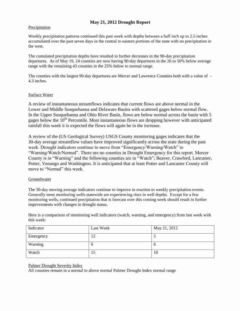
May 21, 2012 Drought Report Precipitation
Weekly precipitation patterns continued this past week with depths between a half inch up to 2.5 inches
accumulated over the past seven days in the central to eastern portions of the state with no precipitation in
the west.
The cumulated precipitation depths have resulted in further decreases in the 90-day precipitation
departures. As of May 19, 24 counties are now having 90-day departures in the 26 to 50% below average
range with the remaining 43 counties in the 25% below to normal range.
The counties with the largest 90-day departures are Mercer and Lawrence Counties both with a value of -
4.3 inches.
Surface Water
A review of instantaneous streamflows indicates that current flows are above normal in the
Lower and Middle Susquehanna and Delaware Basins with scattered gages below normal flow.
In the Upper Susquehanna and Ohio River Basin, flows are below normal across the basin with 5
gages below the 10th
Percentile. Most instantaneous flows are dropping however with anticipated
rainfall this week it is expected the flows will again be in the increase.
A review of the (US Geological Survey) USGS County monitoring gages indicates that the
30-day average streamflow values have improved significantly across the state during the past
week. Drought indicators continue to move from “Emergency/Warning/Watch” to
“Warning/Watch/Normal”. There are no counties in Drought Emergency for this report. Mercer
County is in “Warning” and the following counties are in “Watch”; Beaver, Crawford, Lancaster,
Potter, Venango and Washington. It is anticipated that at least Potter and Lancaster County will
move to “Normal” this week.
Groundwater
The 30-day moving average indicators continue to improve in reaction to weekly precipitation events.
Generally most monitoring wells statewide are experiencing rises in well depths. Except for a few
monitoring wells, continued precipitation that is forecast over this coming week should result in further improvements with changes in drought status.
Here is a comparison of monitoring well indicators (watch, warning, and emergency) from last week with
this week:
Indicator Last Week May 21, 2012
Emergency 12 5
Warning 6 6
Watch 15 10
Palmer Drought Severity Index
All counties remain in a normal to above normal Palmer Drought Index normal range
Forecast
On a short term, NOAA is forecasting accumulated depths for the next five days up to about 2.5 inches in
the south-central part of the state with much of the rest of the state getting in the range of 0.5 inches up to
1.5 inches. The northwest is expected to receive up to 0.5 inches. Longer term forecasting for May 29th
to June 6th calls for significant precipitation of up to about four to five inches in the central to east with
lesser amounts in the west.
Public Water Supply Agencies
There are no known Public Water Supply Agencies currently on voluntary or mandatory water use
restrictions.
Summary
Conditions continue to improve for many areas across the Commonwealth except in the northwest where
there has been a lack of precipitation over the past two weeks. Conditions will be monitored closely. A
Drought Task Force meeting has been scheduled for June 14 at 1:00 at PEMA to discuss conditions.
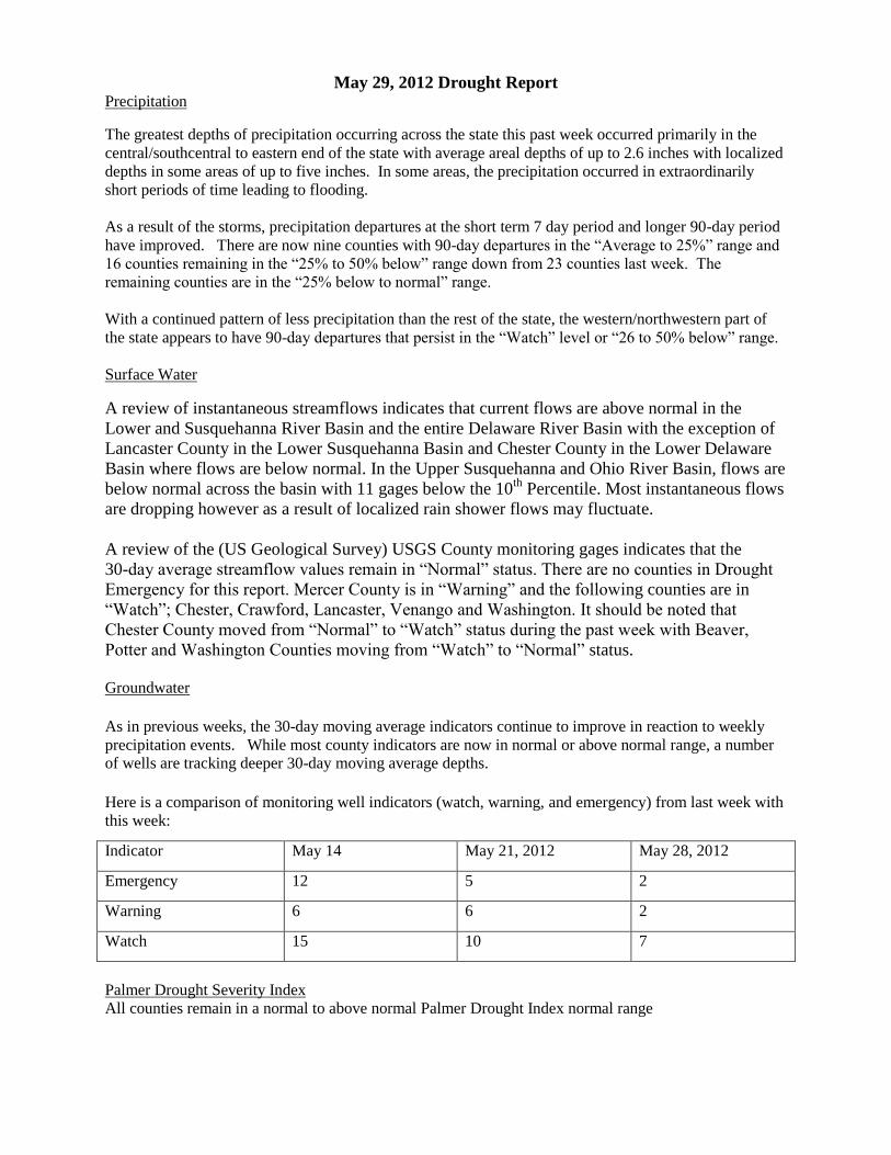
May 29, 2012 Drought Report Precipitation
The greatest depths of precipitation occurring across the state this past week occurred primarily in the
central/southcentral to eastern end of the state with average areal depths of up to 2.6 inches with localized
depths in some areas of up to five inches. In some areas, the precipitation occurred in extraordinarily
short periods of time leading to flooding.
As a result of the storms, precipitation departures at the short term 7 day period and longer 90-day period
have improved. There are now nine counties with 90-day departures in the “Average to 25%” range and
16 counties remaining in the “25% to 50% below” range down from 23 counties last week. The
remaining counties are in the “25% below to normal” range.
With a continued pattern of less precipitation than the rest of the state, the western/northwestern part of
the state appears to have 90-day departures that persist in the “Watch” level or “26 to 50% below” range.
Surface Water
A review of instantaneous streamflows indicates that current flows are above normal in the
Lower and Susquehanna River Basin and the entire Delaware River Basin with the exception of
Lancaster County in the Lower Susquehanna Basin and Chester County in the Lower Delaware
Basin where flows are below normal. In the Upper Susquehanna and Ohio River Basin, flows are
below normal across the basin with 11 gages below the 10th
Percentile. Most instantaneous flows
are dropping however as a result of localized rain shower flows may fluctuate.
A review of the (US Geological Survey) USGS County monitoring gages indicates that the
30-day average streamflow values remain in “Normal” status. There are no counties in Drought
Emergency for this report. Mercer County is in “Warning” and the following counties are in
“Watch”; Chester, Crawford, Lancaster, Venango and Washington. It should be noted that
Chester County moved from “Normal” to “Watch” status during the past week with Beaver,
Potter and Washington Counties moving from “Watch” to “Normal” status.
Groundwater
As in previous weeks, the 30-day moving average indicators continue to improve in reaction to weekly
precipitation events. While most county indicators are now in normal or above normal range, a number of wells are tracking deeper 30-day moving average depths.
Here is a comparison of monitoring well indicators (watch, warning, and emergency) from last week with
this week:
Indicator May 14 May 21, 2012 May 28, 2012
Emergency 12 5 2
Warning 6 6 2
Watch 15 10 7
Palmer Drought Severity Index
All counties remain in a normal to above normal Palmer Drought Index normal range
Forecast
NOAA forecasts of precipitation over the next five days calls for up to 1.5 inches across the central to
eastern end of the state with the northwest potentially receiving up to two inches. Longer term
forecasting for June 6th through June 14
th calls for precipitation in the range of 0.25 to 0.5 inches
somewhat evenly distributed across the state.
Public Water Supply Agencies
There are no known Public Water Supply Agencies currently on voluntary or mandatory water use
restrictions.
Summary
Conditions are improving for areas across the state with the exception of the northwest and the southeast.
Conditions will continue to be monitored closely. A Drought Task Force meeting has been scheduled for
June 14 at 1:00 at PEMA to discuss conditions.
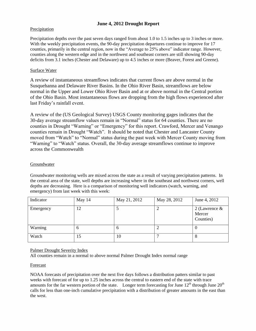
June 4, 2012 Drought Report Precipitation
Precipitation depths over the past seven days ranged from about 1.0 to 1.5 inches up to 3 inches or more.
With the weekly precipitation events, the 90-day precipitation departures continue to improve for 17
counties, primarily in the central region, now in the “Average to 25% above” indicator range. However,
counties along the western edge and in the northwest and southeast corners are still showing 90-day
deficits from 3.1 inches (Chester and Delaware) up to 4.5 inches or more (Beaver, Forest and Greene).
Surface Water
A review of instantaneous streamflows indicates that current flows are above normal in the
Susquehanna and Delaware River Basins. In the Ohio River Basin, streamflows are below
normal in the Upper and Lower Ohio River Basin and at or above normal in the Central portion
of the Ohio Basin. Most instantaneous flows are dropping from the high flows experienced after
last Friday’s rainfall event.
A review of the (US Geological Survey) USGS County monitoring gages indicates that the
30-day average streamflow values remain in “Normal” status for 64 counties. There are no
counties in Drought “Warning” or “Emergency” for this report. Crawford, Mercer and Venango
counties remain in Drought “Watch”. It should be noted that Chester and Lancaster County
moved from “Watch” to “Normal” status during the past week with Mercer County moving from
“Warning” to “Watch” status. Overall, the 30-day average streamflows continue to improve
across the Commonwealth
Groundwater
Groundwater monitoring wells are mixed across the state as a result of varying precipitation patterns. In
the central area of the state, well depths are increasing where in the southeast and northwest corners, well
depths are decreasing. Here is a comparison of monitoring well indicators (watch, warning, and emergency) from last week with this week:
Indicator May 14 May 21, 2012 May 28, 2012 June 4, 2012
Emergency 12 5 2 2 (Lawrence &
Mercer Counties)
Warning 6 6 2 0
Watch 15 10 7 8
Palmer Drought Severity Index
All counties remain in a normal to above normal Palmer Drought Index normal range
Forecast
NOAA forecasts of precipitation over the next five days follows a distribution patters similar to past
weeks with forecast of for up to 1.25 inches across the central to eastern end of the state with trace
amounts for the far western portion of the state. Longer term forecasting for June 12th through June 20
th
calls for less than one-inch cumulative precipitation with a distribution of greater amounts in the east than
the west.

Public Water Supply Agencies
There are no known Public Water Supply Agencies currently on voluntary or mandatory water use
restrictions.
Summary
Conditions are improving for areas in the central portion of the state with the exception of the northwest
and the southeast. Conditions will continue to be monitored closely. A Drought Task Force meeting has
been scheduled for June 14 at 1:00 at PEMA to discuss conditions.
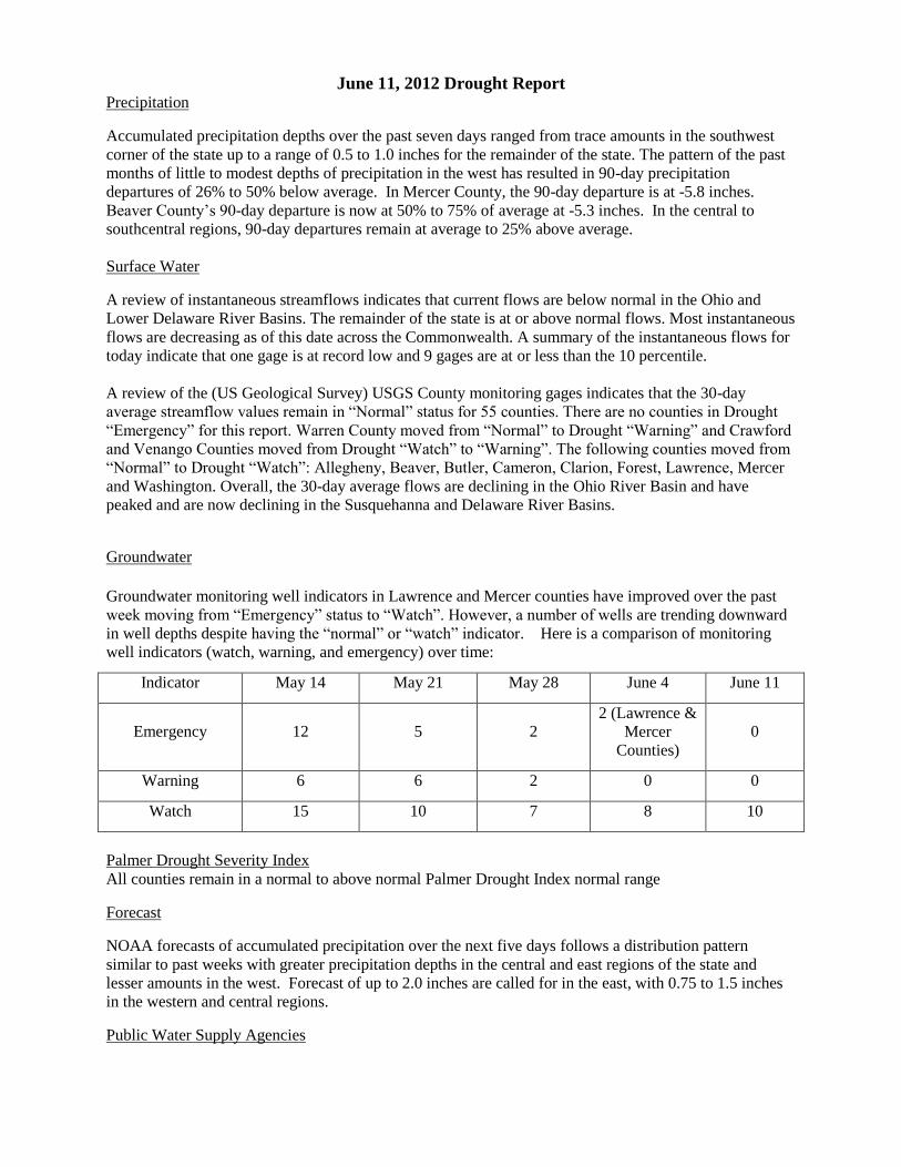
June 11, 2012 Drought Report Precipitation
Accumulated precipitation depths over the past seven days ranged from trace amounts in the southwest
corner of the state up to a range of 0.5 to 1.0 inches for the remainder of the state. The pattern of the past
months of little to modest depths of precipitation in the west has resulted in 90-day precipitation
departures of 26% to 50% below average. In Mercer County, the 90-day departure is at -5.8 inches.
Beaver County’s 90-day departure is now at 50% to 75% of average at -5.3 inches. In the central to
southcentral regions, 90-day departures remain at average to 25% above average.
Surface Water
A review of instantaneous streamflows indicates that current flows are below normal in the Ohio and
Lower Delaware River Basins. The remainder of the state is at or above normal flows. Most instantaneous
flows are decreasing as of this date across the Commonwealth. A summary of the instantaneous flows for
today indicate that one gage is at record low and 9 gages are at or less than the 10 percentile.
A review of the (US Geological Survey) USGS County monitoring gages indicates that the 30-day
average streamflow values remain in “Normal” status for 55 counties. There are no counties in Drought
“Emergency” for this report. Warren County moved from “Normal” to Drought “Warning” and Crawford
and Venango Counties moved from Drought “Watch” to “Warning”. The following counties moved from
“Normal” to Drought “Watch”: Allegheny, Beaver, Butler, Cameron, Clarion, Forest, Lawrence, Mercer
and Washington. Overall, the 30-day average flows are declining in the Ohio River Basin and have
peaked and are now declining in the Susquehanna and Delaware River Basins.
Groundwater
Groundwater monitoring well indicators in Lawrence and Mercer counties have improved over the past
week moving from “Emergency” status to “Watch”. However, a number of wells are trending downward
in well depths despite having the “normal” or “watch” indicator. Here is a comparison of monitoring
well indicators (watch, warning, and emergency) over time:
Indicator May 14 May 21 May 28 June 4 June 11
Emergency 12 5 2 2 (Lawrence &
Mercer
Counties)
0
Warning 6 6 2 0 0
Watch 15 10 7 8 10
Palmer Drought Severity Index
All counties remain in a normal to above normal Palmer Drought Index normal range
Forecast
NOAA forecasts of accumulated precipitation over the next five days follows a distribution pattern
similar to past weeks with greater precipitation depths in the central and east regions of the state and
lesser amounts in the west. Forecast of up to 2.0 inches are called for in the east, with 0.75 to 1.5 inches
in the western and central regions.
Public Water Supply Agencies
There are no known Public Water Supply Agencies currently on voluntary or mandatory water use
restrictions.
Summary
While conditions have improved for areas in the central and eastern portions of the state, the lack of
precipitation in the western portion of the state has resulted in increasing deficits as well as declining
streamflows. Conditions will continue to be monitored closely. The Drought Task Force is meeting on
June 14 at 1:00 at PEMA to discuss conditions.
Update to 6/11/12 Drought Report
At the request of the Commonwealth Drought Coordinator, the June 14th
Drought Task Force
meeting has been rescheduled to July 12th
at 1:00, so that conditions can be discussed at that
time.
June 18, 2012 Drought Report Precipitation
The state received accumulated precipitation over the past seven days ranging from 0.10 inches to a few
small areas receiving up to approximately 1.5inches. The greatest depths occurred along several northern
counties and counties just south of the Ridge and Valley Physiographic Province. Overall, precipitation
depths were modest and not enough to significantly change the departures over the last 90-days.
Precipitation departures over 90 days did slightly improve in the central and east over those reported on
June 11th with additional counties in the central and east now in the “average to 25%” range. But in the
west, there has been only a slight change in departures with Lawrence and Mercer counties joining
Beaver County in being in “51% to 75% below” range.
Surface Water
A review of instantaneous streamflows indicates that current flows continue to flow at below normal
levels in the Ohio and Lower Delaware River Basins. The remainder of the state is at normal flow with
sporadic gages below normal. Most instantaneous flows are decreasing as of this date across the
Commonwealth. A summary of the instantaneous flows for today indicate that one gage is at record low
and 4 gages are at less than the 10th Percentile.
A review of the (US Geological Survey) USGS County monitoring gages indicates that the 30-day
average streamflow values remain in “Normal” status for 53 counties. There are no counties in Drought
“Emergency” for this report. McKean and Somerset County moved from “Normal” to Drought “Watch”
and Butler and Beaver County moved from Drought “Watch” to “Warning”. The following counties are
in Drought “Watch”: Allegheny, Cameron, Clarion, Forest, Lawrence, McKean, Mercer, Somerset and
Washington. Butler, Beaver, Crawford, Venango and Warren are in Drought “Warning”. Overall, the 30-
day average flows are declining across the state.
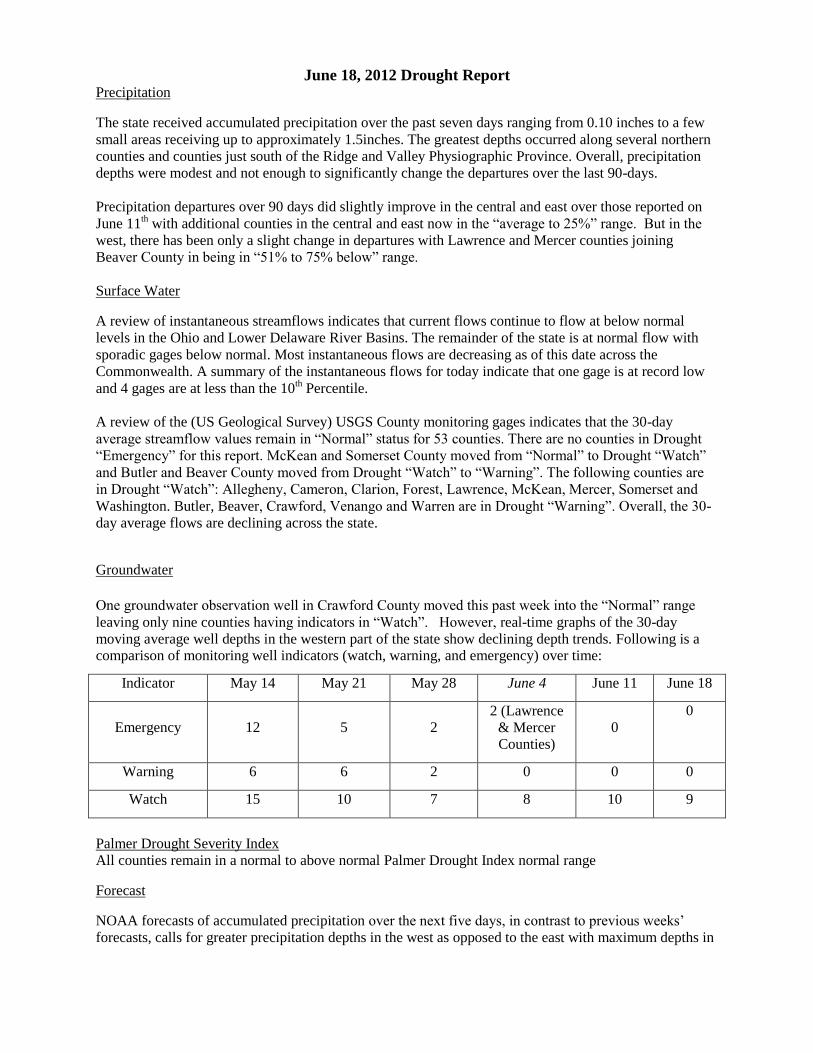
Groundwater
One groundwater observation well in Crawford County moved this past week into the “Normal” range
leaving only nine counties having indicators in “Watch”. However, real-time graphs of the 30-day
moving average well depths in the western part of the state show declining depth trends. Following is a comparison of monitoring well indicators (watch, warning, and emergency) over time:
Indicator May 14 May 21 May 28 June 4 June 11 June 18
Emergency 12 5 2 2 (Lawrence
& Mercer Counties)
0
0
Warning 6 6 2 0 0 0
Watch 15 10 7 8 10 9
Palmer Drought Severity Index
All counties remain in a normal to above normal Palmer Drought Index normal range
Forecast
NOAA forecasts of accumulated precipitation over the next five days, in contrast to previous weeks’
forecasts, calls for greater precipitation depths in the west as opposed to the east with maximum depths in
the range of up to about 1 inch. The longer-term forecast for June 18 through June 25 is similar with
accumulated precipitation to be up to the one inch range evenly distributed across the state.
Public Water Supply Agencies
There are no known Public Water Supply Agencies currently on voluntary or mandatory water use
restrictions.
Summary
While conditions have improved for areas in the central and eastern portions of the state, the lack of
precipitation in the western portion of the state has resulted in increasing deficits as well as declining
streamflows. Conditions will continue to be monitored closely.
The Drought Task Force is scheduled to meet on July 12 at 1:00 at PEMA to discuss conditions.
June 26, 2012 Drought Report Precipitation
The state received accumulated precipitation over the past seven days ranging from little to no
precipitation up to the ½ inch range between Lycoming County and Pike County. The majority of the
state received less than 0.3 inches.
Negative precipitation departures over 90 days have increased in the western portion of the state through
the northern tier as indicated by Venango County moving into the “51% to 75% below average” and
Bradford County moving from “Average to 25% above average” to “25% below to average” for the 90-
day departure from average indicator. Meanwhile, other areas of the state remain at or above the “25%
below to average” levels.
Surface Water
A review of instantaneous streamflows indicates that current flows are below normal across the state with
the lowest levels in the Ohio and Lower Delaware River Basins. Most instantaneous flows are decreasing
as of this date across the Commonwealth. A summary of the instantaneous flows for today indicate that
one gage is at record low and 13 gages are at less than the 10th Percentile.
A review of the (US Geological Survey) USGS County monitoring gages indicates that the 30-day
average streamflow values are in “Normal” status for 54 counties. Beaver County moved from Drought
“Warning” to “Emergency”. Cameron, Clarion and Somerset Counties moved from “Watch” to “Normal”
status for this report. Other changes include Greene and Fayette County moving from “Normal” to
“Watch” and Warren County moving from “Warning” to “Watch” status. A summary of status conditions
are as follows: Counties in “Watch” are Allegheny, Fayette, Forest, Greene, Lawrence, McKean, Mercer,
Warren and Washington; Counties in “Warning” are Butler, Crawford and Venango; Beaver County in
“Emergency”. Overall, the 30-day flows are declining across the state at various rates of decline.
Groundwater
Groundwater monitoring well indicators have, over the past week, shown improvements in McKean and
Potter Counties moving from “Watch” levels to “Normal”. Groundwater levels have continued on a
larger downward trend in the west with four counties (Green, Fayette, Somerset and Allegheny moving
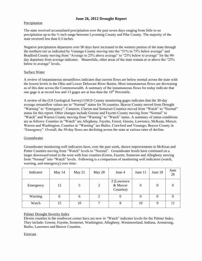
from “Normal” into “Watch” levels. Following is a comparison of monitoring well indicators (watch, warning, and emergency) over time:
Indicator May 14 May 21 May 28 June 4 June 11 June 18 June 26
Emergency 12 5 2 2 (Lawrence
& Mercer
Counties)
0 0 0
Warning 6 6 2 0 0 0 0
Watch 15 10 7 8 10 9 11
Palmer Drought Severity Index
Eleven counties in the southwest corner have are now in “Watch” indicator levels for the Palmer Index.
They include: Greene, Fayette, Somerset, Washington, Allegheny, Westmoreland, Indiana, Armstrong,
Butler, Lawrence and Beaver Counties.
Forecast
NOAA is forecasting little precipitation across the state over the next five days with amounts predicted
equal to or less than 0.1 inches. The longer-term forecast from July 4 through July 12 calls for depths of
one inch or less uniformly across the state.
Public Water Supply Agencies
There are no known Public Water Supply Agencies currently on voluntary or mandatory water use
restrictions.
Summary
Dry conditions persist in the western portion of the state and will be monitored closely. The Drought Task
Force is scheduled to meet on July 12 at 1:00 at PEMA to discuss conditions.
July 7, 2012 Drought Report Precipitation
Over the past seven days, the greatest depths of precipitation fell primarily in two bands: along the
southern Allegheny Plateau region and along the northern tier from Erie County through Pike County
with up to one inch of mean areal precipitation within Somerset County. Depths of less than 0.5 inches
mean area precipitation fell within the Piedmont and Great Valley sections.
Compared with last week’s report, there were only several changes to county 90-day departures from
average classifications. The western counties continue to remain in departures from “20% to 50% below”
to “51% to 75% below” with maximum negative departures among Mercer, Lawrence and Beaver
Counties with values of -6.4, -6.2, and -5.9 respectively.
Similar patterns show on a longer term with the western part of the state having 180-day departures from
normal between -5.6 and 7.3 inches.
Surface Water
A review of instantaneous streamflows indicates that current flows are at below normal across
the state with the lowest levels in the Ohio and Lower Delaware River Basins. Instantaneous
flows are decreasing as of this date across the Commonwealth. A summary of the instantaneous
flows for today indicate that one gage is at record low and 14 gages are at less than the 10th
Percentile.
A review of the (US Geological Survey) USGS County monitoring gages indicates that the
30-day average streamflow values are in “Normal” status for 52 counties. McKean County
moved from “Watch” to “Normal” status for this report. Other changes include Philadelphia,
Somerset and Westmoreland counties moving from “Normal” to “Watch”; Butler moving from
“Warning” to “Watch”; and Washington County moving from “Watch” to “Warning” status. A
summary of status conditions are as follows: Counties in “Watch” are Allegheny, Butler, Fayette,
Forest, Greene, Lawrence, Mercer, Philadelphia, Somerset, Warren and Westmoreland; Counties
in “Warning” are Crawford, Venango and Washington; Beaver County in “Emergency”. Overall,
the 30-day flows are declining across the state at various rates of decline.
It should be noted that at this time, the USGS gage for Beaver County, USGS 03108000
Raccoon Creek at Moffatts Mill, PA, is having reporting difficulties and USGS is investigating
the problem. However, it is assumed that the county remains in “Emergency” status at this time.
Groundwater
Two additional counties have entered into Watch indicator level – Wayne and Susquehanna Counties.
Observation of individual well 30-day moving averages shows a downward trend to a number of wells,
but not in a regional pattern. Only a few wells appear to be trending close to a change in indicator status
over the next week or two. No wells indicate an imminent threat of moving into emergency indicator
levels at this time. Following is a comparison of monitoring well indicators (watch, warning, and emergency) over time:
Indicator May 28 June 4 June 11 June 18 June
26 July 2
Emergency 2 2 (Lawrence
& Mercer Counties)
0 0 0 0
Warning 2 0 0 0 0 0
Watch 7 8 10 9 11
13 (Wayne
and
Susquehanna
Counties added)
Palmer Drought Severity Index
No change from last week. Eleven counties in the southwest corner have are now in “Watch” indicator
levels for the Palmer Index. They include: Greene, Fayette, Somerset, Washington, Allegheny,
Westmoreland, Indiana, Armstrong, Butler, Lawrence and Beaver Counties.
Forecast
The forecast over the next five days calls for up to 0.5 inch of precipitation in the northwest part of the
state with a ranch of up to one inch in the remainder of the state. The forecast for July 10 through 18 calls
for up to an inch somewhat evenly distributed across the state. Unfortunately, forecasts call for greater
depths (2 to 6 inch range) running south of Pennsylvania during this time period.
Public Water Supply Agencies
There are no known Public Water Supply Agencies currently on voluntary or mandatory water use
restrictions.
Summary
Dry conditions persist in the western portion of the state and will be monitored closely. The Drought Task
Force is scheduled to meet on July 12 at 1:00 at PEMA to discuss conditions.
July 9, 2012 Drought Report Precipitation
The cumulative mean precipitation from July 1 through July 7 varied from no precipitation in
Philadelphia in the east up to 1.6 inches in Mercer County in the west. This polarity had some effect on
the 90-day precipitation departures in the last 90-days with several counties, Mercer, Lawrence and
Beaver moving from “51% to 75% below normal” down to “26% to 50% below normal” indicator. Also
on a positive side, seven other counties within the Ridge and Valley physiographic province also saw a
reduction in their 90-day departures bringing them up to the “Average to 25% above” indicator.
The 120 through 180 day precipitation departures showing watch, warning and emergency indicators for
western and eastern counties suggests perpetuation of chronic, or longer term dry conditions.
Surface Water
A review of instantaneous streamflows indicates that current flows are at below normal across the state
with the lowest levels in the Ohio and Lower Delaware River Basins. Instantaneous flows are decreasing
as of this date across the Commonwealth. A summary of the instantaneous flows for today indicate that
one gage is at record low and 11 gages are at less than the 10th Percentile.
A review of the (US Geological Survey) USGS County monitoring gages indicates that the 30-day
average streamflow values are in “Normal” status for 49 counties as 3 additional counties moved to
drought status. For this report, Chester, Erie and Lancaster County are now in Drought “Watch”.
Additional changes include Fayette and Warren County moving from Drought “Watch” to “Warning” and
Mercer County moving from Drought “Watch” to “Emergency”. A summary of status conditions are as
follows: Counties in “Watch” are Allegheny, Butler, Chester, Erie, Forest, Greene, Lancaster, Lawrence,
Philadelphia, Somerset, and Westmoreland; Counties in “Warning” are Beaver, Crawford, Fayette,
Venango, Washington and Warren; and Mercer County is in “Emergency”. Overall, the 30-day flows are
declining across the state at various rates of decline.
It should be noted that at this time, the USGS gage for Beaver County, USGS 03108000 Raccoon Creek
at Moffatts Mill, PA, was having reporting difficulties and USGS has since adjusted flows for the gage
which now has the 30-day average in Drought “Warning” based on the adjustments. The gage had been
previously indicating Drought “Emergency”.
Groundwater
The extended precipitation deficits have, over the past week, begun to move additional counties into
“Watch” and “Warning” groundwater indicators based on 30-day average groundwater levels with no
counties experiencing an improvement in their indicator. Following is a comparison of monitoring well
indicators (watch, warning, and emergency) over time:
Indicator May 28 June 4 June 11 June 18 June 26
July 2 July 9
Emergency 2 2 (Lawrence
& Mercer
Counties)
0 0 0 0 0
Warning 2 0 0 0 0 0
2
(Somerset
and Fayette added)
Watch 7 8 10 9 11
13 (Wayne
and
Susquehanna
Counties added)
16
Palmer Drought Severity Index
Precipitation deficits and extreme heat conditions have resulted in nine additional western counties
coming into the “Watch” indicator status for a total of 21counties.
Forecast
The forecast through July 14 calls for little precipitation across Pennsylvania with bands of significant
precipitation extending through the mid-Atlantic below Maryland. The longer term forecast from July 17
through July 25 call for precipitation in up to two inches in the Piedmont region with slightly higher
levels up through the Appalachian Plateau.
Public Water Supply Agencies
There are no known Public Water Supply Agencies currently on voluntary or mandatory water use
restrictions due to dry conditions diminishing sources.
Summary
Dry conditions persist in the western portion of the state and will be monitored closely. The Drought Task
Force is scheduled to meet on July 12 at 1:00 at PEMA to discuss conditions.
July 16, 2012 Drought Report Precipitation
Very little precipitation fell through the period July 8 through July 14 with the greatest amounts below one inch accumulating generally along the lower third of the state. The rest of the state received no precipitation to trace amounts. County-specific results from yesterday’s rain were not available at the time of this report. The 90-day precipitation departures reflect the past week rainfall with increasing negative departures from normal in most areas except the lower third of the state. Those counties with the most significant departure include Beaver County at -5.5 inches, Lawrence at -5.2 inches and Venango and Greene Counties at -5.1 inches
Surface Water
A review of instantaneous streamflows indicates that current flows are mostly at below normal levels across the state with the lowest levels in the Ohio River Basin. Instantaneous flows are already decreasing after showers of various intensity crossed the state on Sunday, July 15. A summary of the instantaneous flows for today indicate that one gage is at record low and 9 gages are at less than the 10th Percentile. As a comparison of flows before Sundays afternoon and evening rain showers, there were 6 gages at record lows and 24 at less than the 10th Percentile on Sunday. This reflects the significant decrease in flows and how brief showers can affect the daily instantaneous flows. A review of the (US Geological Survey) USGS County monitoring gages indicates that the 30 day average streamflow values are in “Normal” status for 38 counties as 12 additional counties moved to drought status and one, Greene, moved from “Watch” to “Normal”. For this report the following counties moved from “Normal” to Drought “Watch”: Adams, Armstrong, Bradford, Clarion, Delaware, Elk, Huntingdon, Lackawanna, Luzerne, McKean, Sullivan and Bradford. Additional changes include Erie County moving from Drought “Watch” to “Emergency”; Beaver, Crawford, Venango and Warren Counties moving from Drought “Warning” to “Emergency”; Chester, Lawrence and Westmoreland County moving from Drought “Watch” to “Warning”; and Mercer County improving from Drought “Emergency” to “Warning”. A summary of status conditions are as follows: Counties in “Watch” are Adams, Allegheny, Armstrong, Bradford, Butler, Clarion, Delaware, Elk, Forest, Huntingdon, Lackawanna, Lancaster, Luzerne, McKean, Philadelphia, Somerset, Sullivan and Tioga; Counties in “Warning” are Chester, Fayette, Lawrence, Mercer, Washington and Westmoreland; Counties in “Emergency” are Beaver, Crawford, Erie, Venango and Warren. Overall, the 30-day flows are declining across the state at various rates of decline. Groundwater
The number of Groundwater levels moving out of “normal” conditions continues to increase with an indicator pattern similar to those for county stream monitoring points. The drop in elevations are generally falling at the same rate for the time of year although a number of wells such as in Juniata County are falling at a steeper rate. Following is a comparison of monitoring well indicators (watch, warning, and emergency) over time:
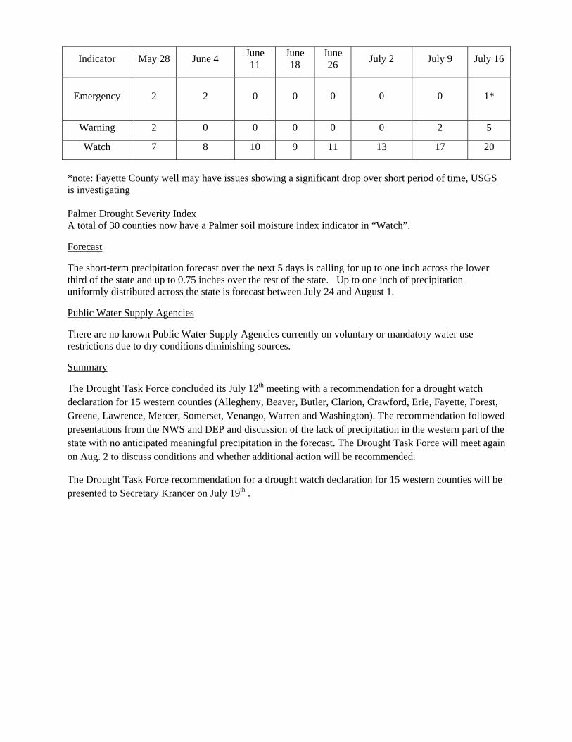
Indicator May 28 June 4 June 11
June 18
June 26 July 2 July 9 July 16
Emergency 2 2 0 0 0 0 0 1*
Warning 2 0 0 0 0 0 2 5
Watch 7 8 10 9 11 13 17 20
*note: Fayette County well may have issues showing a significant drop over short period of time, USGS is investigating Palmer Drought Severity Index A total of 30 counties now have a Palmer soil moisture index indicator in “Watch”.
Forecast
The short-term precipitation forecast over the next 5 days is calling for up to one inch across the lower third of the state and up to 0.75 inches over the rest of the state. Up to one inch of precipitation uniformly distributed across the state is forecast between July 24 and August 1.
Public Water Supply Agencies
There are no known Public Water Supply Agencies currently on voluntary or mandatory water use restrictions due to dry conditions diminishing sources.
Summary
The Drought Task Force concluded its July 12th meeting with a recommendation for a drought watch declaration for 15 western counties (Allegheny, Beaver, Butler, Clarion, Crawford, Erie, Fayette, Forest, Greene, Lawrence, Mercer, Somerset, Venango, Warren and Washington). The recommendation followed presentations from the NWS and DEP and discussion of the lack of precipitation in the western part of the state with no anticipated meaningful precipitation in the forecast. The Drought Task Force will meet again on Aug. 2 to discuss conditions and whether additional action will be recommended.
The Drought Task Force recommendation for a drought watch declaration for 15 western counties will be presented to Secretary Krancer on July 19th .
July 23, 2012 Drought Report Precipitation
Storm events within the Ridge and Valley and portions of the Piedmont province provided accumulations of between 1.7 and 2.9 inches of rainfall with lesser amounts in the remaining areas. This welcome rainfall reduced the 90-day departures from normal across the state slightly with several counties, Union, Cumberland, Fulton and Bedford moving into the 26% to 50% departure from normal. The precipitation departures for the 90-day period continue to display watch through emergency indicators for 14 western counties.
Surface Water
A review of the (US Geological Survey) USGS County monitoring gages indicates that the 30-day average streamflow values are in “Normal” status for 44 counties as 8 counties moved from “Watch” to “Normal” and 2 counties moved from “Normal” to “Watch”. For this report the following counties moved from “Normal” to Drought “Watch”: Berks and Cameron and following counties moved from Drought “Watch” to “Normal”: Adams, Allegheny, Huntingdon, Lackawanna, Luzerne, Philadelphia, Somerset and Sullivan. Additional changes include Beaver County moving from Drought “Emergency” to “Watch”; Crawford and Venango counties moving from Drought “Emergency” to “Warning”; and Clarion County moving from Drought “Watch” to “Warning”.
A summary of status conditions are as follows: Counties in “Watch” are Armstrong, Beaver, Berks, Bradford, Butler, Cameron, Delaware, Elk, Forest, Fayette, Lancaster, Lawrence, McKean, Mercer, Tioga, Washington and Westmoreland; Counties in “Warning” are Chester, Clarion, Crawford and Venango; Counties in “Emergency” are Erie and Warren.
The 30-day average values increased at minimal to moderate rates due to last week’s rainfall but have since begun to decline which indicates baseflow is still at significantly below normal levels.
Instantaneous flow data was not available for this report
Groundwater
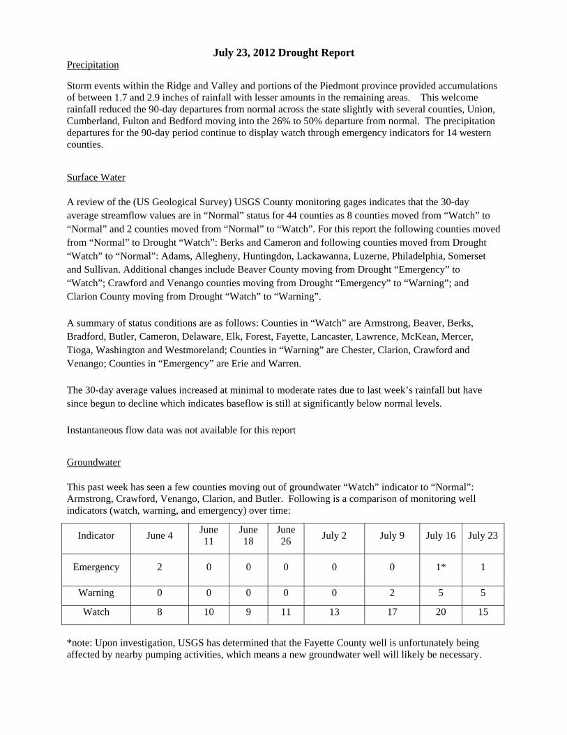
This past week has seen a few counties moving out of groundwater “Watch” indicator to “Normal”: Armstrong, Crawford, Venango, Clarion, and Butler. Following is a comparison of monitoring well indicators (watch, warning, and emergency) over time:
Indicator June 4 June 11
June 18
June 26 July 2 July 9 July 16 July 23
Emergency 2 0 0 0 0 0 1* 1
Warning 0 0 0 0 0 2 5 5
Watch 8 10 9 11 13 17 20 15
*note: Upon investigation, USGS has determined that the Fayette County well is unfortunately being affected by nearby pumping activities, which means a new groundwater well will likely be necessary.
Palmer Drought Severity Index Ten counties this past week moved from “Watch” indicator to “Warning” – all in the northwest: Erie, Crawford, Warren, McKean, Potter, Mercer, Venango, Clarion and Forest and Jefferson. Meanwhile, 16 counties in the Northeast were added to the “Watch” indicator. Only 18 of 67 counties remain in “Normal” Palmer Index Indicator status.
Forecast
The National Weather Service is forecasting a range of 2 to 3.9 inches of rainfall in the Appalachian Plateau region. The Ridge and Valley and Piedmont region forecasts are expected to range between 0.5 and 1.5 inches. Longer term forecasting between July 31 and August 8 calls for ranges between 0.5 and 2 inches.
Public Water Supply Agencies
There are no known Public Water Supply Agencies currently on voluntary or mandatory water use restrictions due to dry conditions diminishing sources.
Summary
DEP issued a press release on July 19th for a drought watch declaration for 15 western counties implementing the Drought Task Force recommendations from the previous week. The 15 counties in drought watch are: Allegheny, Beaver, Butler, Clarion, Crawford, Erie, Fayette, Forest, Greene, Lawrence, Mercer, Somerset, Venango, Warren and Washington. Conditions will continue to be closely monitored.
The next Drought Task Force meeting is scheduled for Aug. 2 at which time conditions will be assessed to determine if any action is necessary.
July 30, 2012 Drought Report Precipitation
Last week, much needed rainfall fell across the Appalachian plateau region in depths between 1.7 and 3.0 inches that has resulted in significant improvements in the 90-day mean precipitation departure indicators. Currently only Beaver County is now listed below the “25% to average” indicator range as a “26% to 50% below normal”, indicator. The number in this indicator is down from 13 counties last week.
Surface Water A review of the (US Geological Survey) USGS County monitoring gages indicates that the 30-day average streamflow values are in “Normal” status for 52 counties as 8 counties moved from “Watch” to “Normal”. For this report the following counties moved from Drought “Watch” to “Normal”: Armstrong, Beaver, Berks, Butler, Cameron, Fayette, Mercer and Westmoreland. Additional changes include Warren County moving from Drought “Emergency” to “Watch” and Clarion, Crawford and Venango County moving from Drought “Warning” to “Watch”. A summary of status conditions are as follows: Counties in “Watch” are Bradford, Clarion, Crawford, Delaware, Elk, Forest, Lancaster, Lawrence, McKean, Tioga, Venango, Warren and Washington; Chester County is in Drought “Warning” and Warren County is in Drought “Emergency”. The 30-day average values are increasing in the western portion of the state and the far eastern part of Pennsylvania with most of the Susquehanna River Basin reflecting decreasing values. Instantaneous flow data for this date indicates above normal flows in the Ohio River Basin and Upper Delaware River Basin with the remainder at below normal flows. Groundwater
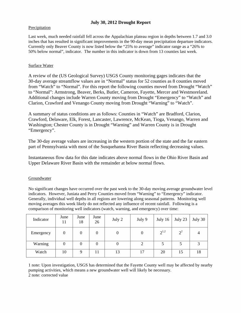
No significant changes have occurred over the past week to the 30-day moving average groundwater level indicators. However, Juniata and Perry Counties moved from “Warning” to “Emergency” indicator. Generally, individual well depths in all regions are lowering along seasonal patterns. Monitoring well moving averages this week likely do not reflected any influence of recent rainfall. Following is a comparison of monitoring well indicators (watch, warning, and emergency) over time:
Indicator June 11
June 18
June 26 July 2 July 9 July 16 July 23 July 30
Emergency 0 0 0 0 0 21,2 22 4
Warning 0 0 0 0 2 5 5 3
Watch 10 9 11 13 17 20 15 18
1 note: Upon investigation, USGS has determined that the Fayette County well may be affected by nearby pumping activities, which means a new groundwater well will likely be necessary. 2 note: corrected value
Palmer Drought Severity Index Recent precipitation has resulted in an improvement to the Palmer indictor in portions of the northeast and southwest regions of the state with a total of 15 counties moving from “Watch” back into “Normal” indicator status.
Forecast
Over the next five days, the National Weather Service is forecasting a range of between 0.25 and 0.8 inches of rainfall with the highest amounts in the east and northeast. Longer term forecasting between August 7 and August 15 calls for cumulative amounts between 0.25 and 2 inches with greater depths in the east.
Public Water Supply Agencies
DEP was made aware of one public water supplier, Duncannon Borough, Perry County, going into mandatory water restrictions on July 26, 2012 due to low water supplies related to lack of precipitation and an offline well.
Summary
DEP issued a press release on July 19th for a drought watch declaration for 15 western counties implementing the Drought Task Force recommendations from the previous week. The 15 counties in drought watch are: Allegheny, Beaver, Butler, Clarion, Crawford, Erie, Fayette, Forest, Greene, Lawrence, Mercer, Somerset, Venango, Warren and Washington. While recent precipitation has resulted in overall improved conditions to precipitation departures, surface water levels and soil moisture, indicators will continue to be closely monitored until the next Drought Task Force meeting which is scheduled for Aug. 2. At that time conditions will be assessed to determine if any change to the declaration status is necessary.
Update to 7/30/12 Drought Report
The Drought Task Force met on 8/2/12 to discuss current hydrologic conditions and drought management activities. After presentations from the NWS and DEP and a brief discussion, there was general consensus from the Task Force to keep the Drought Watch declaration for 15 western counties, monitor conditions and meet again in four weeks to reassess conditions.
(Revised on 8/3/12)
August 7, 2012 Drought Report Precipitation
The middle third of the state received the most precipitation this week in ranges between 1.2 and 1.8 inches from the border of Maryland up to the New York border. Unfortunately, the western and southeastern parts of the state continued to receive lesser amounts of rain. The 90-day precipitation departures from normal vary from a deficit of -2.9 inches up to an excess of 5 inches in Fulton County. Only 8 out of 67 counties now have indicators other than “normal or above”. Surface Water A review of the (US Geological Survey) USGS County monitoring gages indicates that the 30-day average streamflow values are in “Normal” status for 59 counties as 7 counties moved from “Watch” to “Normal”. For this report the following counties moved from Drought “Watch” to “Normal”: Clarion, Elk, Forest, Lancaster, Lawrence, Tioga and Washington. Additional changes include Erie County moving from Drought “Emergency” to “Warren”. A summary of status conditions are as follows: Counties in “Watch” are Bradford, Crawford, Delaware, McKean, Venango and Warren. Chester and Erie Counties are in Drought “Warning”. The 30-day average values overall are decreasing in the Ohio River Basin and notably in Chester County. The remainder of the state is experiencing overall rising 30-day average flows. Instantaneous flow data for this data indicates below normal flows in the Ohio River Basin, the North Branch of the Susquehanna River and in the Lower Delaware Basin specifically in Chester and Delaware counties. Instantaneous flows for the remainder of the state is mostly above normal. Groundwater
As in the past week, no negative changes occurred in the past week for the groundwater indicator. A few counties showed an improvement with Juniata and Perry Counties moved back into “Warning” from “Emergency” indicator. Following is a comparison of monitoring well indicators (watch, warning, and emergency) over time:
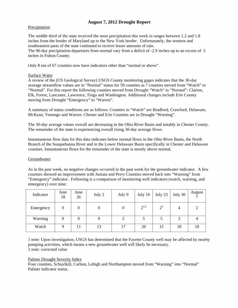
Indicator June 18
June 26 July 2 July 9 July 16 July 23 July 30 August
7
Emergency 0 0 0 0 21,2 22 4 2
Warning 0 0 0 2 5 5 3 4
Watch 9 11 13 17 20 15 18 18
1 note: Upon investigation, USGS has determined that the Fayette County well may be affected by nearby pumping activities, which means a new groundwater well will likely be necessary. 2 note: corrected value Palmer Drought Severity Index Four counties, Schuylkill, Carbon, Lehigh and Northampton moved from “Warning” into “Normal” Palmer indicator status.
Forecast
Over the next five days, the National Weather Service is forecasting a range of between 0.25 and 1.75 inches of rainfall with the highest amounts in the northeast corner along the Delaware River. Longer term forecasting between August 15 and August 23 calls for cumulative amounts of up to 1 inch somewhat uniformly distributed across the state.
Public Water Supply Agencies
This week, Corry Borough, Erie County went into voluntary water conservation advisory as they were having difficulty keeping up with water demand.
The previous week, DEP was made aware of one public water supplier, Duncannon Borough, Perry County, going into mandatory water restrictions on July 26, 2012 due to low water supplies related to lack of precipitation and an offline well. No further information on this.
Summary
Rainfall this past week has continued to modestly improve indicators in some regions. The consensus of the Drought Task Force during its August 2nd meeting was to continue to monitor conditions and reassess in four weeks. No change to declaration status.
August 13, 2012 Drought Report Precipitation
Precipitation between August 5th and August 11th averaged between 0.7 and 2.3 inches. The central part of the state between Indiana and Juniata Counties received the least of this precipitation in ranges below 1.0 inch. The 90-day precipitation departures improved in a few counties however two counties, Greene and Washington, moved from “25% below to average” down to “25% to 50% below”. Across the Commonwealth, with the exception of the Chester, Delaware and Philadelphia Counties with negative departures, the remainder of the Piedmont and Ridge and Valley provinces have positive departures (average to above average) and the Appalachian Plateau Region generally having slight negative departures except for the four counties: Warren, Beaver, Greene and Washington that have departures of -3.2, -2.8, -3 and -3.1 respectively. Surface Water A review of the (US Geological Survey) USGS County monitoring gages indicates that the 30-day average streamflow values are in “Normal” status for 61 counties as 2 additional counties moved from “Watch” to “Normal”. For this report the following counties moved from Drought “Watch” to “Normal”: Delaware and McKean. Additional changes include Chester County moving from Drought “Warning” to “Watch”. A summary of status conditions are as follows: Counties in “Watch” are Bradford, Chester, Crawford, Venango and Warren. Erie County remains in Drought “Warning”. Compared to three to four weeks ago, the 30-day average values have improved across the state as of this date. Instantaneous flow data for this date indicates below normal flows in the Upper Ohio River Basin, the West Branch Susquehanna River Basin, and in the Lower Delaware Basin specifically in Berks and Chester counties. Instantaneous flows for the remainder of the state is mostly above normal. Groundwater
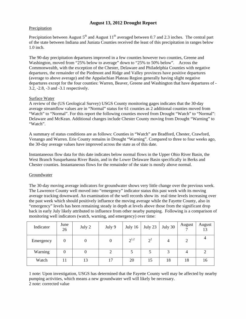
The 30-day moving average indicators for groundwater shows very little change over the previous week. The Lawrence County well moved into “emergency” indicator status this past week with its moving average tracking downward. An examination of the well records show its real time levels increasing over the past week which should positively influence the moving average while the Fayette County, also in “emergency” levels has been remaining steady in depth at levels above those from the significant drop back in early July likely attributed to influence from other nearby pumping. Following is a comparison of monitoring well indicators (watch, warning, and emergency) over time:
Indicator June 26 July 2 July 9 July 16 July 23 July 30 August
7 August
13
Emergency 0 0 0 21,2 22 4 2 4
Warning 0 0 2 5 5 3 4 2
Watch 11 13 17 20 15 18 18 16
1 note: Upon investigation, USGS has determined that the Fayette County well may be affected by nearby pumping activities, which means a new groundwater well will likely be necessary. 2 note: corrected value
Palmer Drought Severity Index No change from last week.
Forecast
The NOAA forecast is calling for rainfall between 0.5 and 1.25 inches across the state through August 20th with a longer term forecast of between 0.5 and 2 inches between August 21st and August 29th.
Public Water Supply Agencies
In past weeks, Corry Borough, Erie County went into voluntary water conservation advisory as they were having difficulty keeping up with water demand and Duncannon Borough, Perry County, went into mandatory water restrictions on July 26, 2012 due to low water supplies related to lack of precipitation and an offline well. No updates have been reported on these two systems.
This past week, DEP learned of Mansfield Borough, Tioga County moving into drought restrictions due to a spring source drying up and an alternative reservoir source having significant algae water quality problems that has limited finished water due to required treatment. Also, Bloomfield Borough Water Authority, Perry County has reported initiation of voluntary water restrictions due to a drop in a well depth triggering Drought Contingency actions.
Summary
Despite the precipitation over the last week, conditions remain about the same as last week and recovery appears to have slowed down. The drought watch declaration for the 15 western counties remains in effect until the Drought Task Force meets on August 30th to discuss conditions and to determine appropriate action based upon those conditions.
August 20, 2012 Drought Report Precipitation
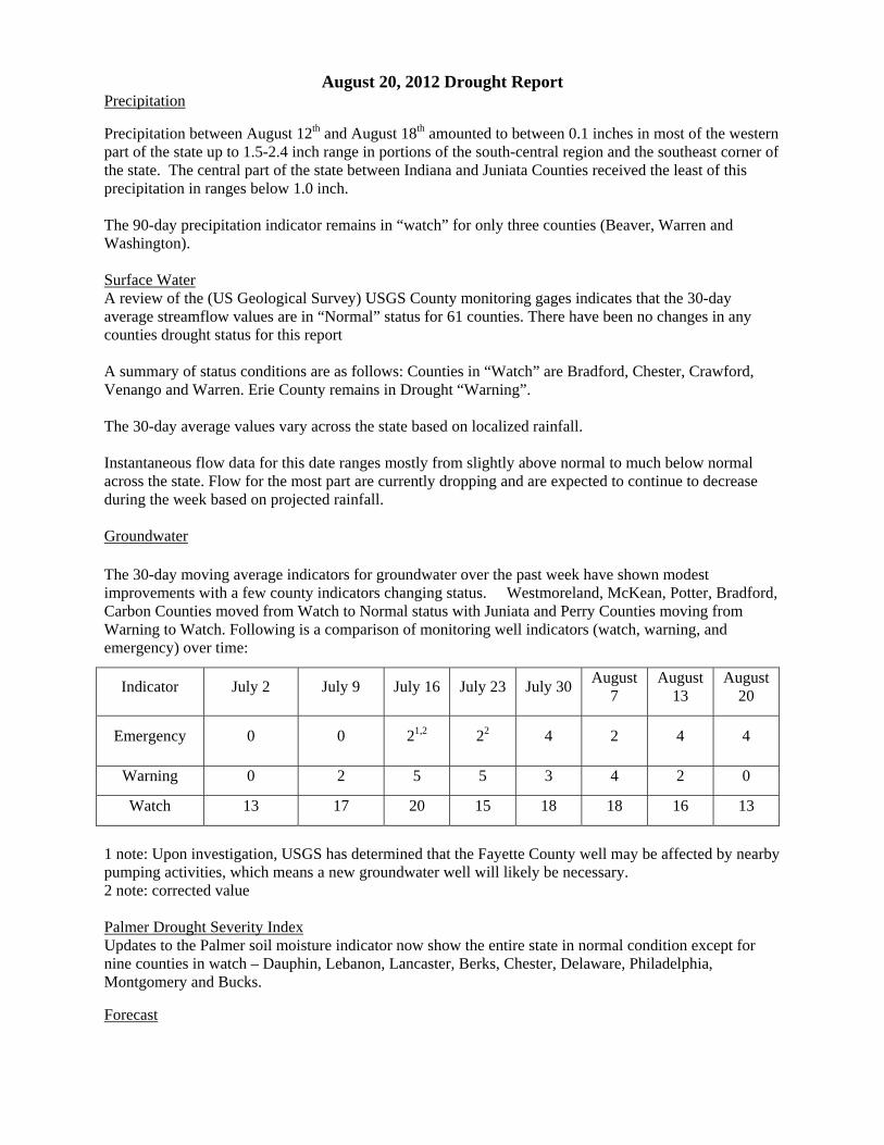
Precipitation between August 12th and August 18th amounted to between 0.1 inches in most of the western part of the state up to 1.5-2.4 inch range in portions of the south-central region and the southeast corner of the state. The central part of the state between Indiana and Juniata Counties received the least of this precipitation in ranges below 1.0 inch. The 90-day precipitation indicator remains in “watch” for only three counties (Beaver, Warren and Washington). Surface Water A review of the (US Geological Survey) USGS County monitoring gages indicates that the 30-day average streamflow values are in “Normal” status for 61 counties. There have been no changes in any counties drought status for this report A summary of status conditions are as follows: Counties in “Watch” are Bradford, Chester, Crawford, Venango and Warren. Erie County remains in Drought “Warning”. The 30-day average values vary across the state based on localized rainfall. Instantaneous flow data for this date ranges mostly from slightly above normal to much below normal across the state. Flow for the most part are currently dropping and are expected to continue to decrease during the week based on projected rainfall. Groundwater
The 30-day moving average indicators for groundwater over the past week have shown modest improvements with a few county indicators changing status. Westmoreland, McKean, Potter, Bradford, Carbon Counties moved from Watch to Normal status with Juniata and Perry Counties moving from Warning to Watch. Following is a comparison of monitoring well indicators (watch, warning, and emergency) over time:
Indicator July 2 July 9 July 16 July 23 July 30 August 7
August 13
August 20
Emergency 0 0 21,2 22 4 2 4 4
Warning 0 2 5 5 3 4 2 0
Watch 13 17 20 15 18 18 16 13
1 note: Upon investigation, USGS has determined that the Fayette County well may be affected by nearby pumping activities, which means a new groundwater well will likely be necessary. 2 note: corrected value Palmer Drought Severity Index Updates to the Palmer soil moisture indicator now show the entire state in normal condition except for nine counties in watch – Dauphin, Lebanon, Lancaster, Berks, Chester, Delaware, Philadelphia, Montgomery and Bucks.
Forecast
The NOAA forecasting over the next five days is calling for less than 0.25 inches anywhere in the state with the longer term forecast for August 28th through September 5th calling for accumulations less than 1.5 inches during that time period.
Public Water Supply Agencies
In past weeks, Corry Borough, Erie County went into voluntary water conservation advisory as they were having difficulty keeping up with water demand and Duncannon Borough, Perry County, went into mandatory water restrictions on July 26, 2012 due to low water supplies related to lack of precipitation and an offline well. A check of these two systems was made. Corry borough is no longer on restrictions- a leak that occurred was repaired. Duncannon Borough is still on mandatory restrictions but is seeing decreased demand and has a scheduled inspection of a well by DEP SCRO that they hope to bring online to help the situation.
No additional information on Mansfield Borough, Tioga County moving into drought restrictions due to a spring source drying up and an alternative reservoir source having significant algae water quality problems that has limited finished water due to required treatment. Also, Bloomfield Borough Water Authority, Perry County has reported initiation of voluntary water restrictions due to a drop in a well depth triggering Drought Contingency actions.
Summary
As a result of above-average precipitation over the past 30-days, with the exception of the extreme southeast corner, conditions have begun to recover across much of the state, with the greatest improvement shown in the western portion of the state as several drought indicators (precipitation deficits, stream flows and soil moisture) begin to return to normal status.
The drought watch declaration for the 15 western counties remains in effect until the Drought Task Force meets on August 30th to discuss conditions and to determine appropriate action based upon those conditions.
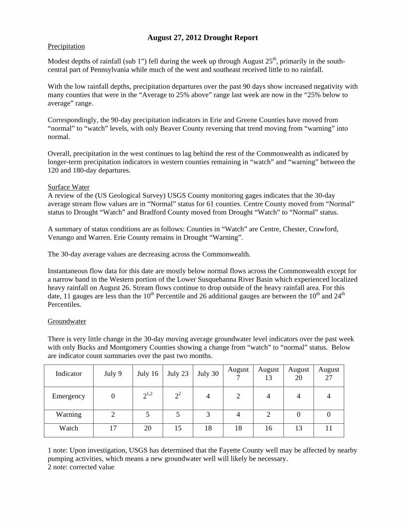
August 27, 2012 Drought Report Precipitation
Modest depths of rainfall (sub 1”) fell during the week up through August 25th, primarily in the south-central part of Pennsylvania while much of the west and southeast received little to no rainfall. With the low rainfall depths, precipitation departures over the past 90 days show increased negativity with many counties that were in the “Average to 25% above” range last week are now in the “25% below to average” range. Correspondingly, the 90-day precipitation indicators in Erie and Greene Counties have moved from “normal” to “watch” levels, with only Beaver County reversing that trend moving from “warning” into normal. Overall, precipitation in the west continues to lag behind the rest of the Commonwealth as indicated by longer-term precipitation indicators in western counties remaining in “watch” and “warning” between the 120 and 180-day departures. Surface Water A review of the (US Geological Survey) USGS County monitoring gages indicates that the 30-day average stream flow values are in “Normal” status for 61 counties. Centre County moved from “Normal” status to Drought “Watch” and Bradford County moved from Drought “Watch” to “Normal” status. A summary of status conditions are as follows: Counties in “Watch” are Centre, Chester, Crawford, Venango and Warren. Erie County remains in Drought “Warning”. The 30-day average values are decreasing across the Commonwealth. Instantaneous flow data for this date are mostly below normal flows across the Commonwealth except for a narrow band in the Western portion of the Lower Susquehanna River Basin which experienced localized heavy rainfall on August 26. Stream flows continue to drop outside of the heavy rainfall area. For this date, 11 gauges are less than the 10th Percentile and 26 additional gauges are between the 10th and 24th Percentiles. Groundwater
There is very little change in the 30-day moving average groundwater level indicators over the past week with only Bucks and Montgomery Counties showing a change from “watch” to “normal” status. Below are indicator count summaries over the past two months.
Indicator July 9 July 16 July 23 July 30 August 7
August 13
August 20
August 27
Emergency 0 21,2 22 4 2 4 4 4
Warning 2 5 5 3 4 2 0 0
Watch 17 20 15 18 18 16 13 11
1 note: Upon investigation, USGS has determined that the Fayette County well may be affected by nearby pumping activities, which means a new groundwater well will likely be necessary. 2 note: corrected value
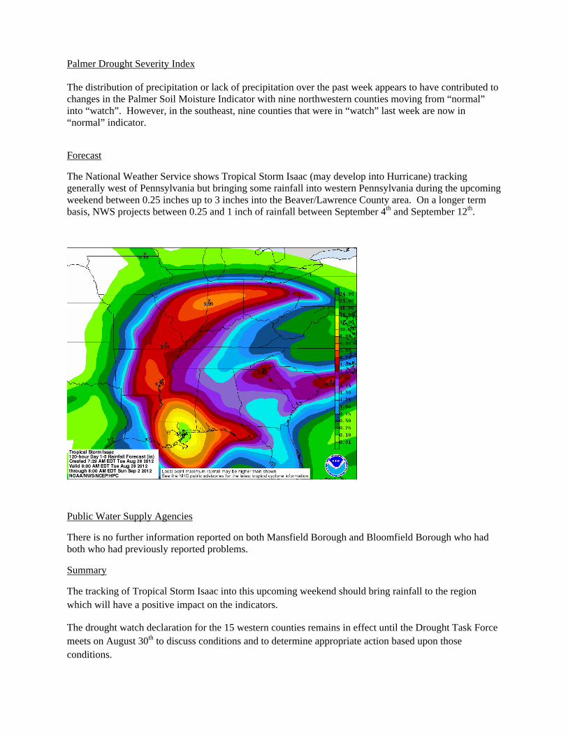
Palmer Drought Severity Index The distribution of precipitation or lack of precipitation over the past week appears to have contributed to changes in the Palmer Soil Moisture Indicator with nine northwestern counties moving from “normal” into “watch”. However, in the southeast, nine counties that were in “watch” last week are now in “normal” indicator.
Forecast
The National Weather Service shows Tropical Storm Isaac (may develop into Hurricane) tracking generally west of Pennsylvania but bringing some rainfall into western Pennsylvania during the upcoming weekend between 0.25 inches up to 3 inches into the Beaver/Lawrence County area. On a longer term basis, NWS projects between 0.25 and 1 inch of rainfall between September 4th and September 12th.
Public Water Supply Agencies
There is no further information reported on both Mansfield Borough and Bloomfield Borough who had both who had previously reported problems.
Summary
The tracking of Tropical Storm Isaac into this upcoming weekend should bring rainfall to the region which will have a positive impact on the indicators.
The drought watch declaration for the 15 western counties remains in effect until the Drought Task Force meets on August 30th to discuss conditions and to determine appropriate action based upon those conditions.
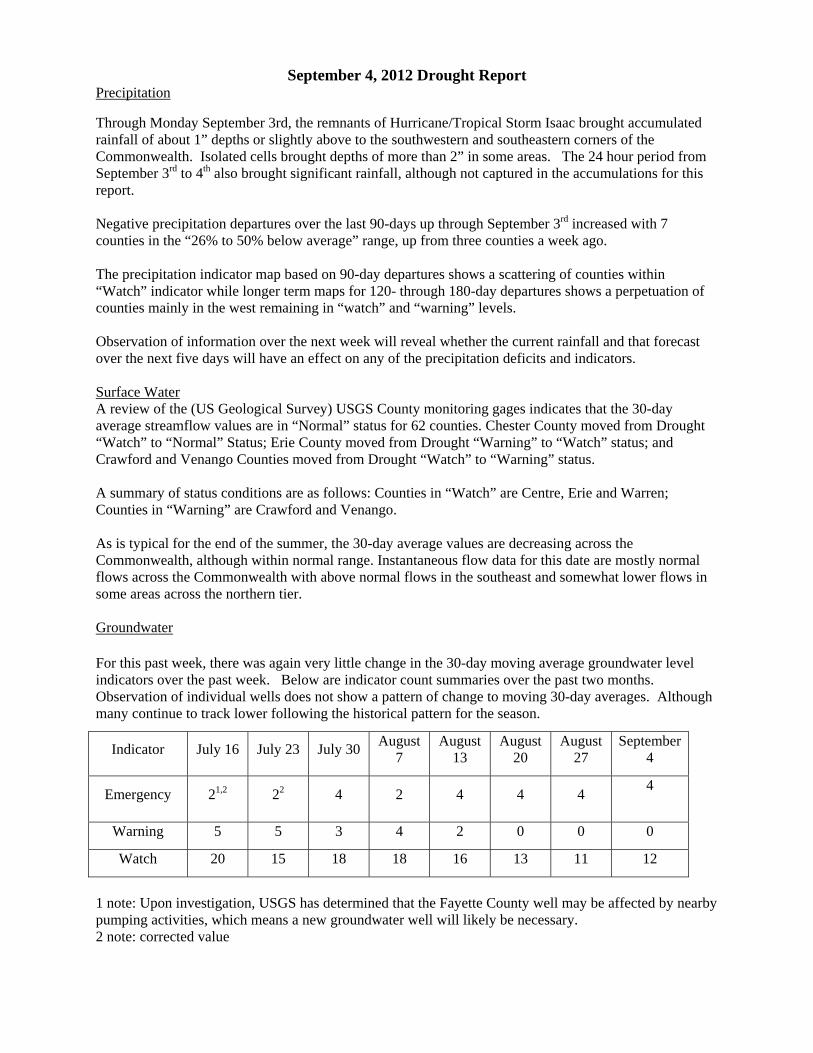
September 4, 2012 Drought Report Precipitation
Through Monday September 3rd, the remnants of Hurricane/Tropical Storm Isaac brought accumulated rainfall of about 1” depths or slightly above to the southwestern and southeastern corners of the Commonwealth. Isolated cells brought depths of more than 2” in some areas. The 24 hour period from September 3rd to 4th also brought significant rainfall, although not captured in the accumulations for this report. Negative precipitation departures over the last 90-days up through September 3rd increased with 7 counties in the “26% to 50% below average” range, up from three counties a week ago. The precipitation indicator map based on 90-day departures shows a scattering of counties within “Watch” indicator while longer term maps for 120- through 180-day departures shows a perpetuation of counties mainly in the west remaining in “watch” and “warning” levels. Observation of information over the next week will reveal whether the current rainfall and that forecast over the next five days will have an effect on any of the precipitation deficits and indicators. Surface Water A review of the (US Geological Survey) USGS County monitoring gages indicates that the 30-day average streamflow values are in “Normal” status for 62 counties. Chester County moved from Drought “Watch” to “Normal” Status; Erie County moved from Drought “Warning” to “Watch” status; and Crawford and Venango Counties moved from Drought “Watch” to “Warning” status. A summary of status conditions are as follows: Counties in “Watch” are Centre, Erie and Warren; Counties in “Warning” are Crawford and Venango. As is typical for the end of the summer, the 30-day average values are decreasing across the Commonwealth, although within normal range. Instantaneous flow data for this date are mostly normal flows across the Commonwealth with above normal flows in the southeast and somewhat lower flows in some areas across the northern tier. Groundwater
For this past week, there was again very little change in the 30-day moving average groundwater level indicators over the past week. Below are indicator count summaries over the past two months. Observation of individual wells does not show a pattern of change to moving 30-day averages. Although many continue to track lower following the historical pattern for the season.
Indicator July 16 July 23 July 30 August 7
August 13
August 20
August 27
September 4
Emergency 21,2 22 4 2 4 4 4 4
Warning 5 5 3 4 2 0 0 0
Watch 20 15 18 18 16 13 11 12
1 note: Upon investigation, USGS has determined that the Fayette County well may be affected by nearby pumping activities, which means a new groundwater well will likely be necessary. 2 note: corrected value
Palmer Drought Severity Index The current Palmer soil moisture indicator has shown an increase in the number of counties in “watch” levels – now at about half of all counties (Regions 2, 3, 9 and 10). However, these indicators were prior to current rainfall events and likely will change over the course of the week.
Forecast
Over the next five days, the NWS is forecasting up to three inches of rainfall in the northeast corner with the remainder of the Commonwealth receiving between 1.25 and 1.8 inches. Between September 12 and 20, little or no precipitation is forecast for most of PA.
Public Water Supply Agencies
There is no further information reported on both Mansfield Borough and Bloomfield Borough who had both who had previously reported problems.
Summary
On August 31, DEP lifted the drought watch for the 15 western counties (Allegheny, Beaver, Butler, Clarion, Crawford, Erie, Fayette, Forest, Greene, Lawrence, Mercer, Somerset, Venango, Warren and Washington) based upon improved conditions since July and the Drought Task Force recommendations. With the issuance of the press release, all counties have been returned to normal.
While conditions have improved, it is not a complete recovery and conditions will be monitored closely. There are no additional Drought Task Force meetings planned at this time.
Even though two of the drought indicators declined slightly from last week (soil moisture and precipitation based on 90-day departures), there was little change to the drought indicators for streamflow and groundwater level. Streamflows are within normal ranges across the state with the exception of below normal flows in the upper Allegheny basin. It is expected that within two to three months, groundwater conditions will be improving.