Embed Size (px)
Citation preview
Maps Unit
4th Grade Social Studies
Medford School District 549c Created by: Anna Meunier and Sarah Flora
Maps Unit 4th Grade Social Studies
Medford School District 549c
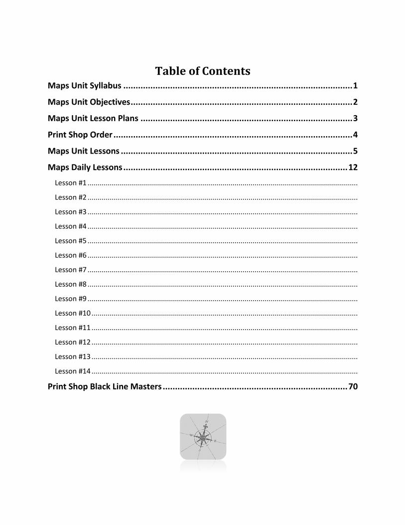
Table of Contents Maps Unit Syllabus ............................................................................................. 1
Maps Unit Objectives .......................................................................................... 2
Maps Unit Lesson Plans ...................................................................................... 3
Print Shop Order ................................................................................................. 4
Maps Unit Lessons .............................................................................................. 5
Maps Daily Lessons ........................................................................................... 12
Lesson #1 ........................................................................................................................................
Lesson #2 ........................................................................................................................................
Lesson #3 ........................................................................................................................................
Lesson #4 ........................................................................................................................................
Lesson #5 ........................................................................................................................................
Lesson #6 ........................................................................................................................................
Lesson #7 ........................................................................................................................................
Lesson #8 ........................................................................................................................................
Lesson #9 ........................................................................................................................................
Lesson #10 ......................................................................................................................................
Lesson #11 ......................................................................................................................................
Lesson #12 ......................................................................................................................................
Lesson #13 ......................................................................................................................................
Lesson #14 ......................................................................................................................................
Print Shop Black Line Masters ........................................................................... 70
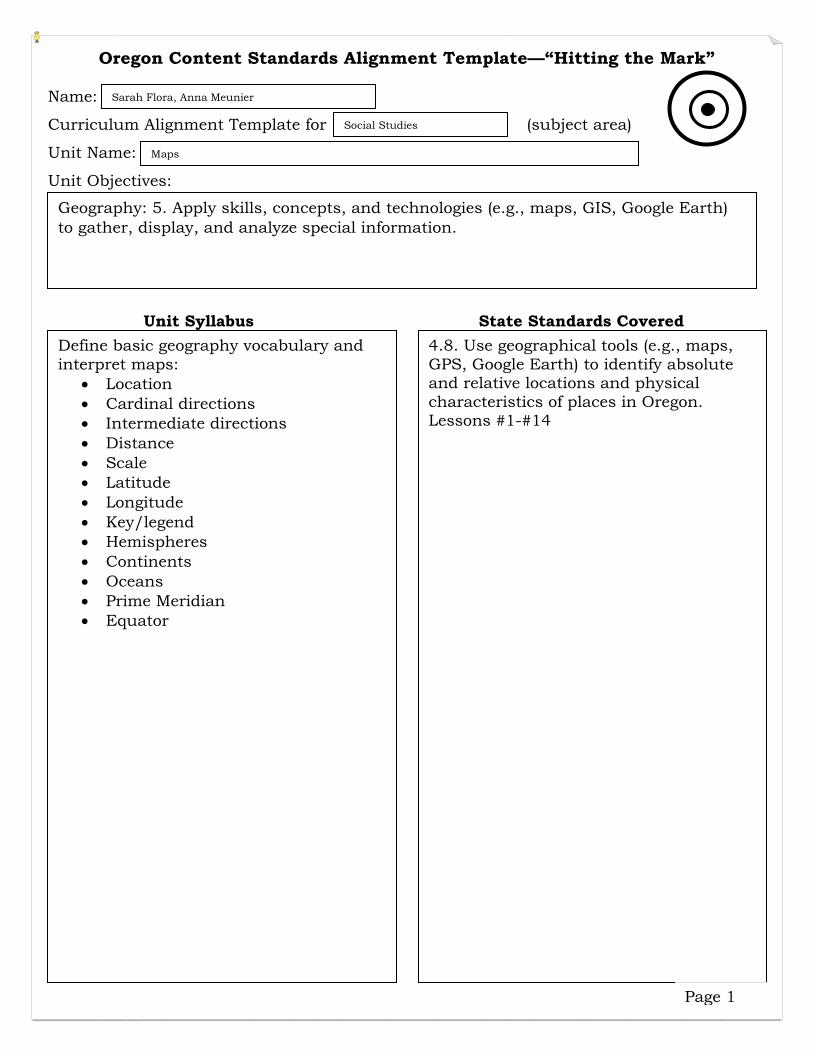
Oregon Content Standards Alignment Template—“Hitting the Mark” Name:
Curriculum Alignment Template for (subject area)
Unit Name:
Unit Objectives:
Unit Syllabus State Standards Covered
Sarah Flora, Anna Meunier
Social Studies
Maps
Geography: 5. Apply skills, concepts, and technologies (e.g., maps, GIS, Google Earth) to gather, display, and analyze special information.
Define basic geography vocabulary and interpret maps:
• Location • Cardinal directions • Intermediate directions • Distance • Scale • Latitude • Longitude • Key/legend • Hemispheres • Continents • Oceans • Prime Meridian • Equator
4.8. Use geographical tools (e.g., maps, GPS, Google Earth) to identify absolute and relative locations and physical characteristics of places in Oregon. Lessons #1-#14
Page 1
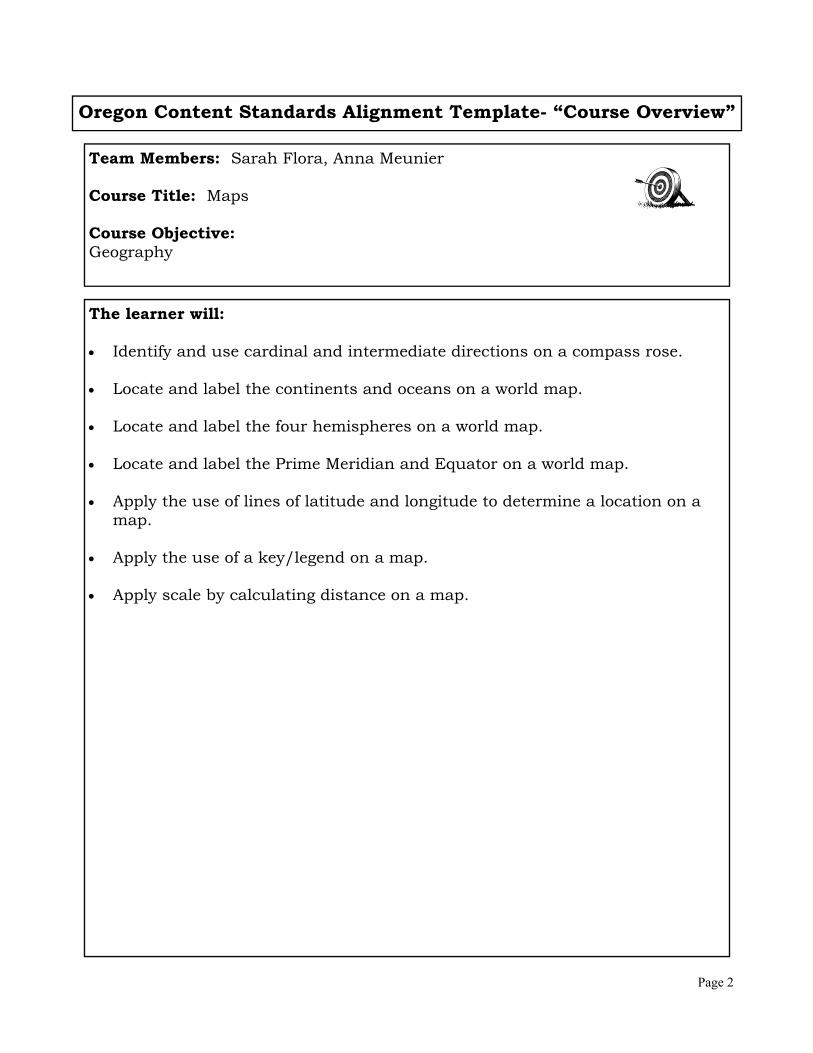
Oregon Content Standards Alignment Template- “Course Overview”
Team Members: Sarah Flora, Anna Meunier Course Title: Maps Course Objective: Geography
The learner will: Identify and use cardinal and intermediate directions on a compass rose. Locate and label the continents and oceans on a world map. Locate and label the four hemispheres on a world map. Locate and label the Prime Meridian and Equator on a world map. Apply the use of lines of latitude and longitude to determine a location on a
map. Apply the use of a key/legend on a map. Apply scale by calculating distance on a map.
Page 2
Maps Unit Page 3
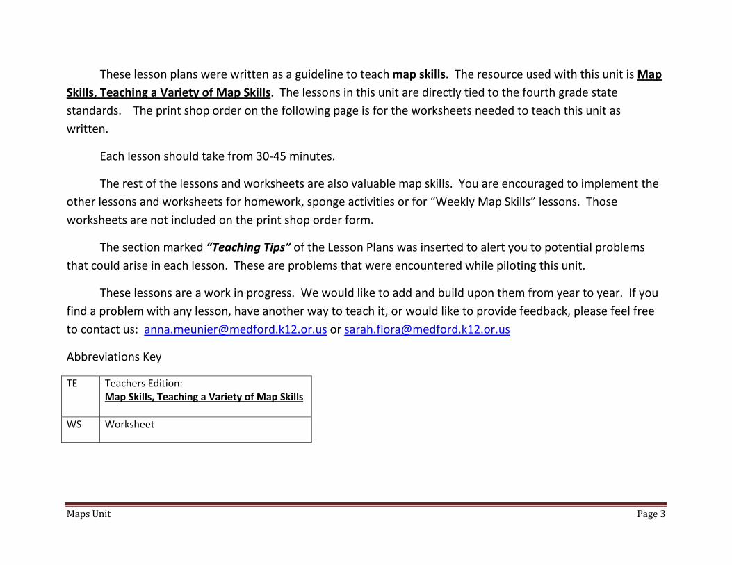
These lesson plans were written as a guideline to teach map skills. The resource used with this unit is Map Skills, Teaching a Variety of Map Skills. The lessons in this unit are directly tied to the fourth grade state standards. The print shop order on the following page is for the worksheets needed to teach this unit as written.
Each lesson should take from 30-45 minutes.
The rest of the lessons and worksheets are also valuable map skills. You are encouraged to implement the other lessons and worksheets for homework, sponge activities or for “Weekly Map Skills” lessons. Those worksheets are not included on the print shop order form.
The section marked “Teaching Tips” of the Lesson Plans was inserted to alert you to potential problems that could arise in each lesson. These are problems that were encountered while piloting this unit.
These lessons are a work in progress. We would like to add and build upon them from year to year. If you find a problem with any lesson, have another way to teach it, or would like to provide feedback, please feel free to contact us: [email protected] or [email protected]
Abbreviations Key
TE Teachers Edition: Map Skills, Teaching a Variety of Map Skills
WS Worksheet
Maps Unit Page 4
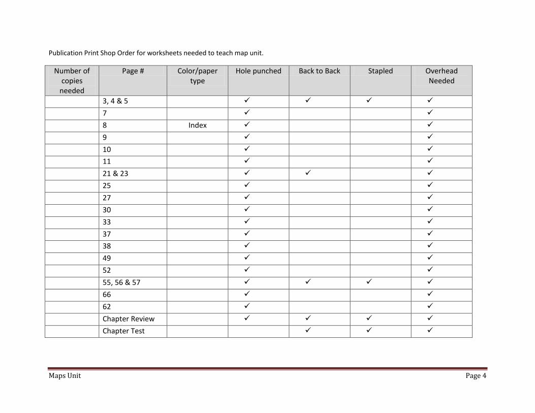
Publication Print Shop Order for worksheets needed to teach map unit.
Number of copies
needed
Page # Color/paper type
Hole punched Back to Back Stapled Overhead Needed
3, 4 & 5
7
8 Index
9
10
11
21 & 23
25
27
30
33
37
38
49
52
55, 56 & 57
66
62
Chapter Review
Chapter Test
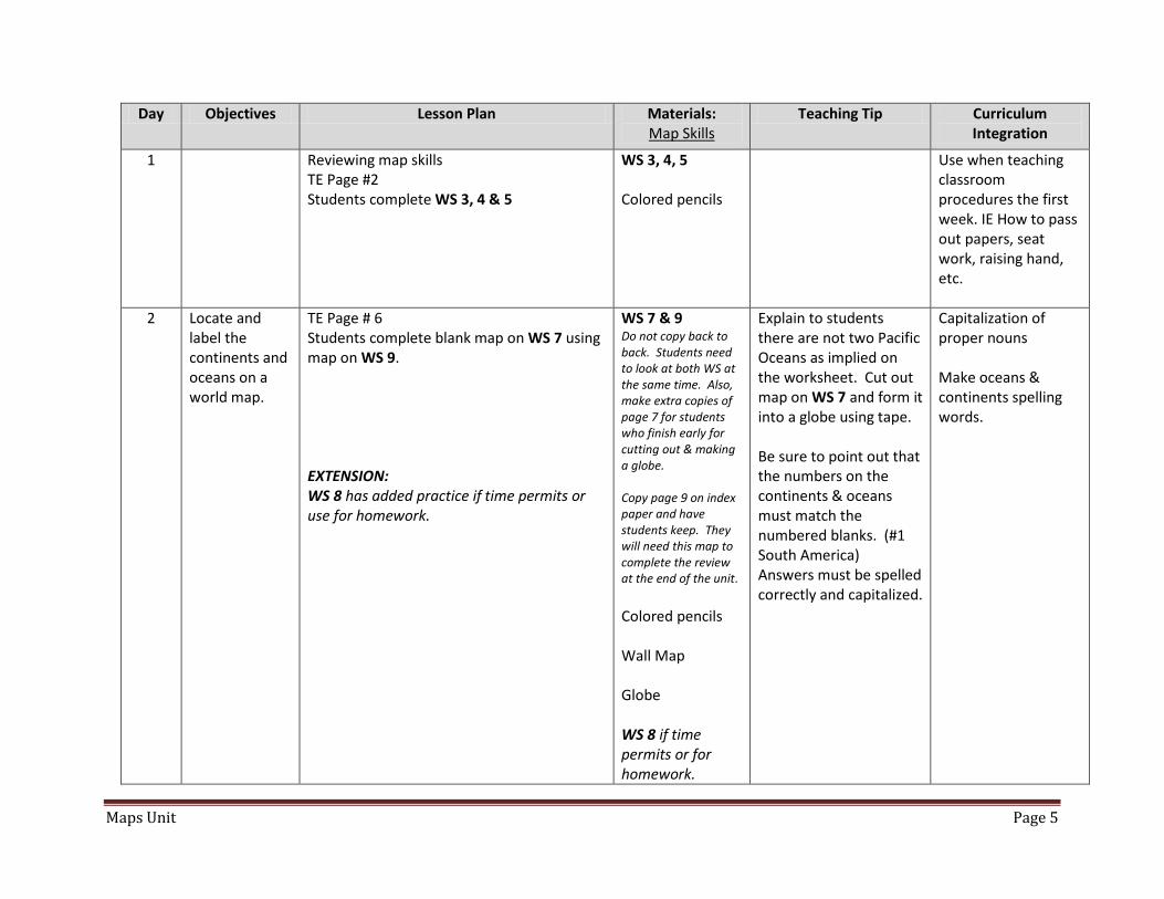
Maps Unit Page 5
Day Objectives Lesson Plan Materials: Map Skills
Teaching Tip Curriculum Integration
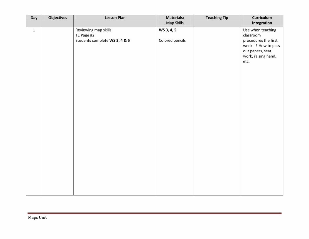
1 Reviewing map skills TE Page #2 Students complete WS 3, 4 & 5
WS 3, 4, 5 Colored pencils
Use when teaching classroom procedures the first week. IE How to pass out papers, seat work, raising hand, etc.
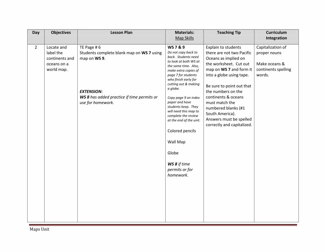
2 Locate and label the continents and oceans on a world map.
TE Page # 6 Students complete blank map on WS 7 using map on WS 9. EXTENSION: WS 8 has added practice if time permits or use for homework.
WS 7 & 9 Do not copy back to back. Students need to look at both WS at the same time. Also, make extra copies of page 7 for students who finish early for cutting out & making a globe. Copy page 9 on index paper and have students keep. They will need this map to complete the review at the end of the unit. Colored pencils Wall Map Globe WS 8 if time permits or for homework.
Explain to students there are not two Pacific Oceans as implied on the worksheet. Cut out map on WS 7 and form it into a globe using tape. Be sure to point out that the numbers on the continents & oceans must match the numbered blanks. (#1 South America) Answers must be spelled correctly and capitalized.
Capitalization of proper nouns Make oceans & continents spelling words.
Maps Unit Page 6
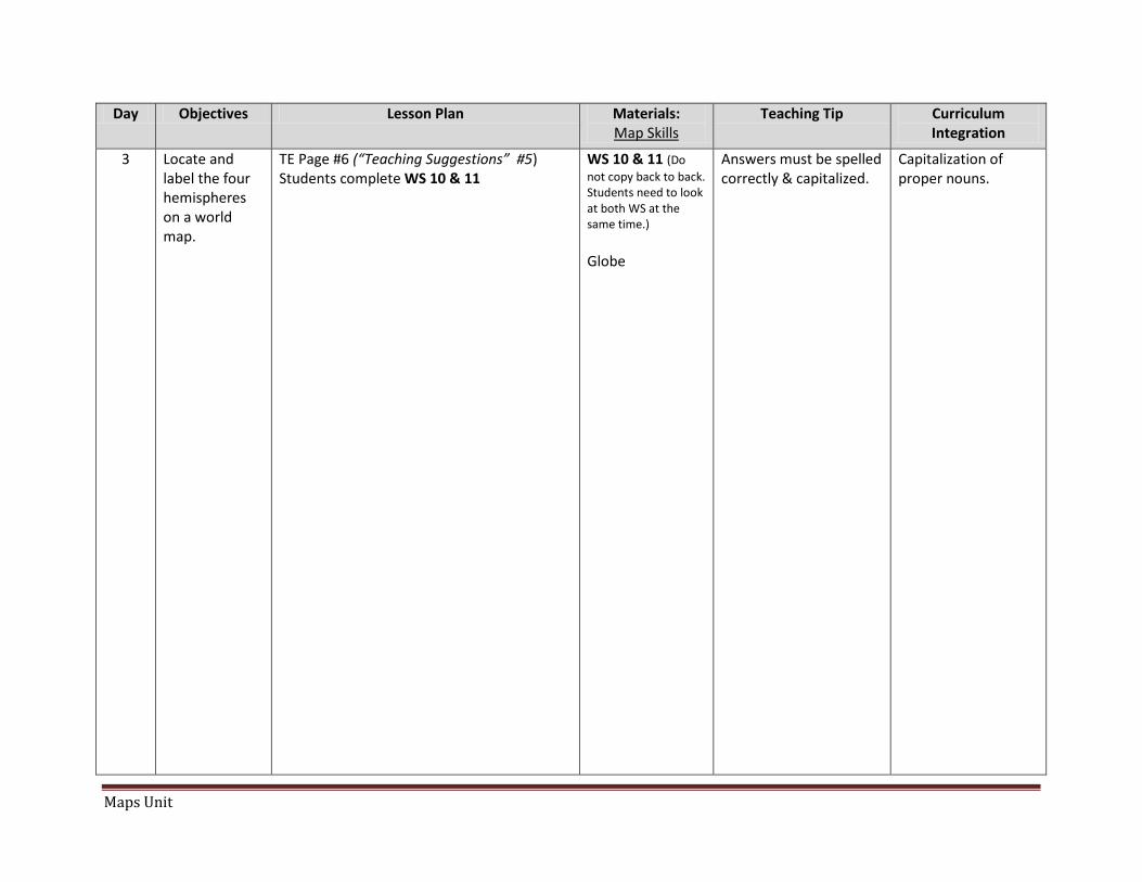
3 Locate and label the four hemispheres on a world map.
TE Page #6 (“Teaching Suggestions” #5) Students complete WS 10 & 11
WS 10 & 11 (Do not copy back to back. Students need to look at both WS at the same time.) Globe
Answers must be spelled correctly & capitalized.
Capitalization of proper nouns.
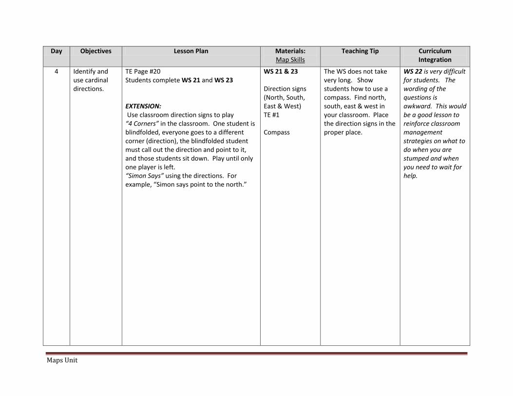
4 Identify and use cardinal directions.
TE Page #20 Students complete WS 21 and WS 23 EXTENSION: Use classroom direction signs to play “4 Corners” in the classroom. One student is blindfolded, everyone goes to a different corner (direction), the blindfolded student must call out the direction and point to it, and those students sit down. Play until only one player is left. “Simon Says” using the directions. For example, “Simon says point to the north.”
WS 21 & 23 Direction signs (North, South, East & West) TE #1 Compass
The WS does not take very long. Show students how to use a compass. Find north, south, east & west in your classroom. Place the direction signs in the proper place.
WS 22 is very difficult for students. The wording of the questions is awkward. This would be a good lesson to reinforce classroom management strategies on what to do when you are stumped and when you need to wait for help.
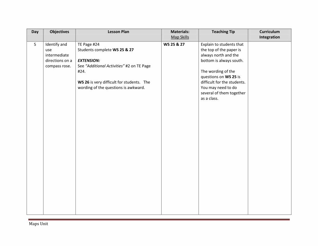
5 Identify and use intermediate directions on a compass rose.
TE Page #24 Students complete WS 25 & 27 EXTENSION: See “Additional Activities” #2 on TE Page #24. WS 26 is very difficult for students. The wording of the questions is awkward.
WS 25 & 27
Explain to students that the top of the paper is always north and the bottom is always south. The wording of the questions on WS 25 is difficult for the students. You may need to do several of them together as a class.
Maps Unit Page 7
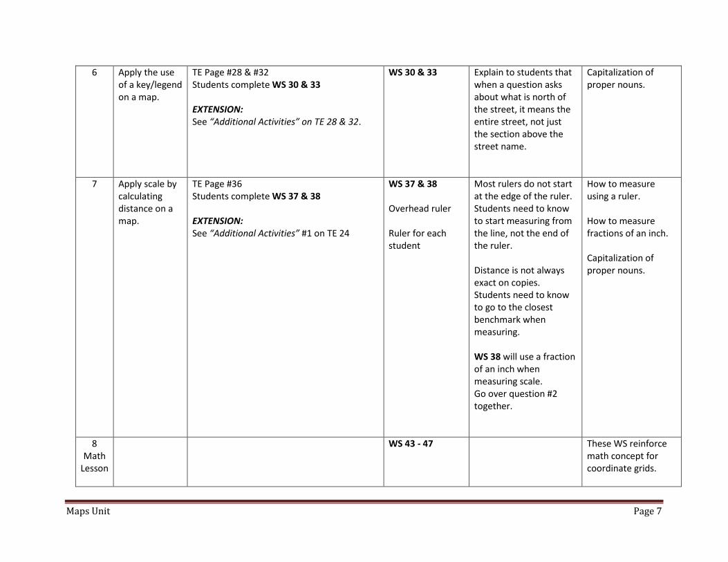
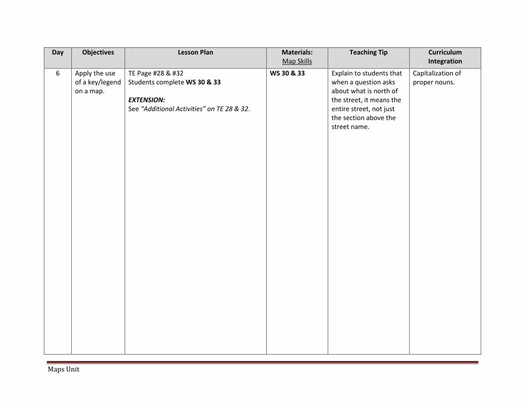
6 Apply the use of a key/legend on a map.
TE Page #28 & #32 Students complete WS 30 & 33 EXTENSION: See “Additional Activities” on TE 28 & 32.
WS 30 & 33
Explain to students that when a question asks about what is north of the street, it means the entire street, not just the section above the street name.
Capitalization of proper nouns.
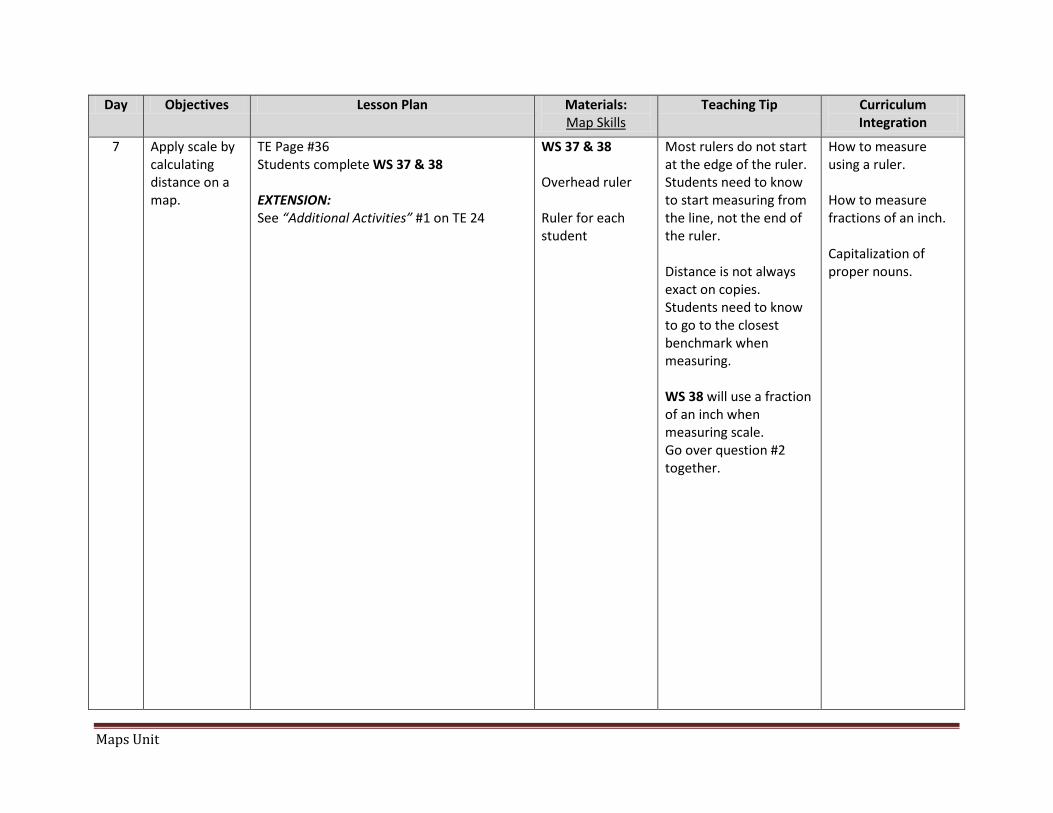
7 Apply scale by calculating distance on a map.
TE Page #36 Students complete WS 37 & 38 EXTENSION: See “Additional Activities” #1 on TE 24
WS 37 & 38 Overhead ruler Ruler for each student
Most rulers do not start at the edge of the ruler. Students need to know to start measuring from the line, not the end of the ruler. Distance is not always exact on copies. Students need to know to go to the closest benchmark when measuring. WS 38 will use a fraction of an inch when measuring scale. Go over question #2 together.
How to measure using a ruler. How to measure fractions of an inch. Capitalization of proper nouns.
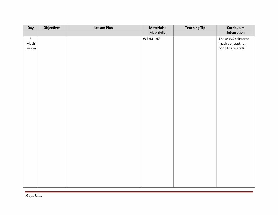
8 Math
Lesson
WS 43 - 47 These WS reinforce math concept for coordinate grids.
Maps Unit Page 8
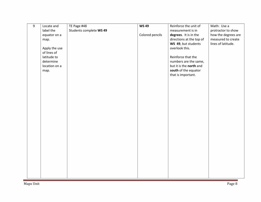
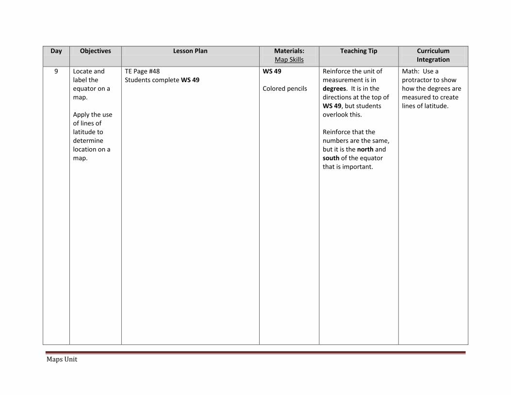
9 Locate and label the equator on a map. Apply the use of lines of latitude to determine location on a map.
TE Page #48 Students complete WS 49
WS 49 Colored pencils
Reinforce the unit of measurement is in degrees. It is in the directions at the top of WS 49, but students overlook this. Reinforce that the numbers are the same, but it is the north and south of the equator that is important.
Math: Use a protractor to show how the degrees are measured to create lines of latitude.
Maps Unit Page 9
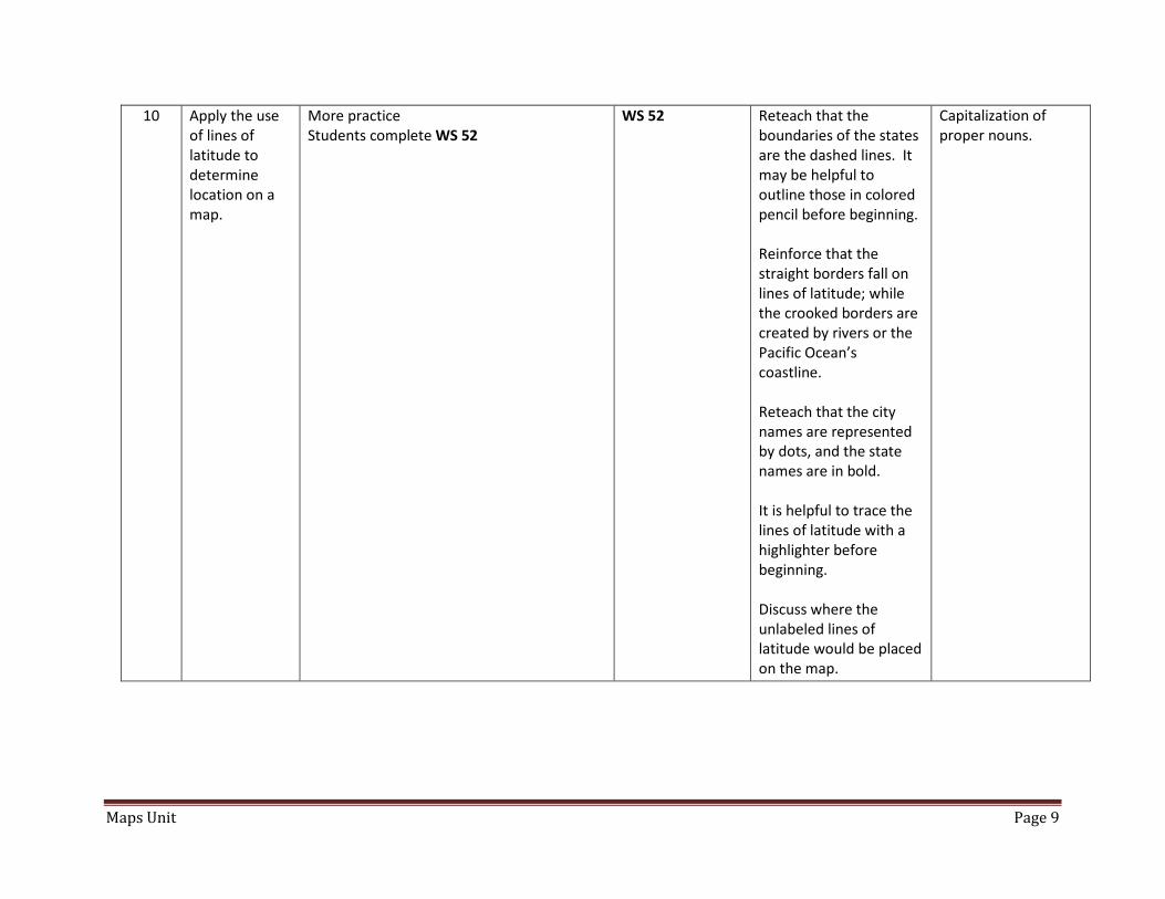
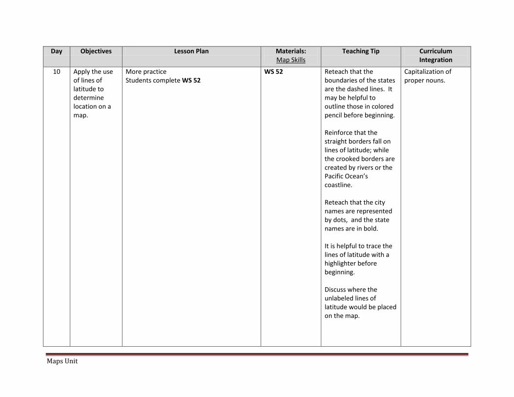
10 Apply the use of lines of latitude to determine location on a map.
More practice Students complete WS 52
WS 52 Reteach that the boundaries of the states are the dashed lines. It may be helpful to outline those in colored pencil before beginning. Reinforce that the straight borders fall on lines of latitude; while the crooked borders are created by rivers or the Pacific Ocean’s coastline. Reteach that the city names are represented by dots, and the state names are in bold. It is helpful to trace the lines of latitude with a highlighter before beginning. Discuss where the unlabeled lines of latitude would be placed on the map.
Capitalization of proper nouns.
Maps Unit Page 10
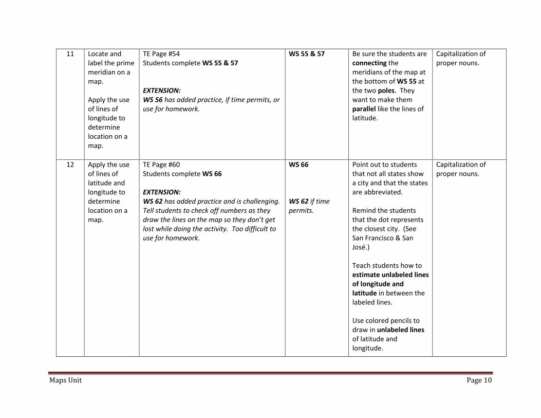
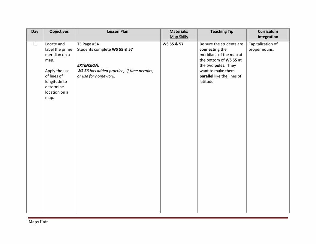
11 Locate and label the prime meridian on a map. Apply the use of lines of longitude to determine location on a map.
TE Page #54 Students complete WS 55 & 57 EXTENSION: WS 56 has added practice, if time permits, or use for homework.
WS 55 & 57
Be sure the students are connecting the meridians of the map at the bottom of WS 55 at the two poles. They want to make them parallel like the lines of latitude.
Capitalization of proper nouns.
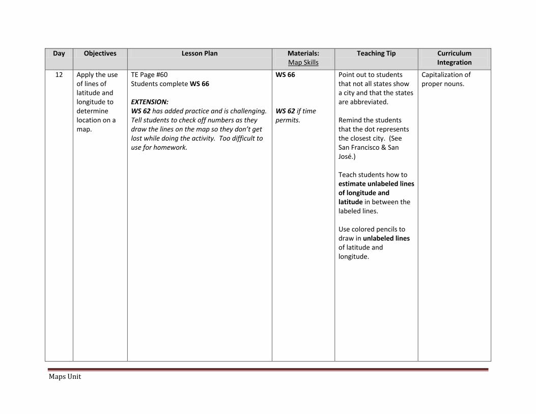
12 Apply the use of lines of latitude and longitude to determine location on a map.
TE Page #60 Students complete WS 66 EXTENSION: WS 62 has added practice and is challenging. Tell students to check off numbers as they draw the lines on the map so they don’t get lost while doing the activity. Too difficult to use for homework.
WS 66 WS 62 if time permits.
Point out to students that not all states show a city and that the states are abbreviated. Remind the students that the dot represents the closest city. (See San Francisco & San José.) Teach students how to estimate unlabeled lines of longitude and latitude in between the labeled lines. Use colored pencils to draw in unlabeled lines of latitude and longitude.
Capitalization of proper nouns.
Maps Unit Page 11
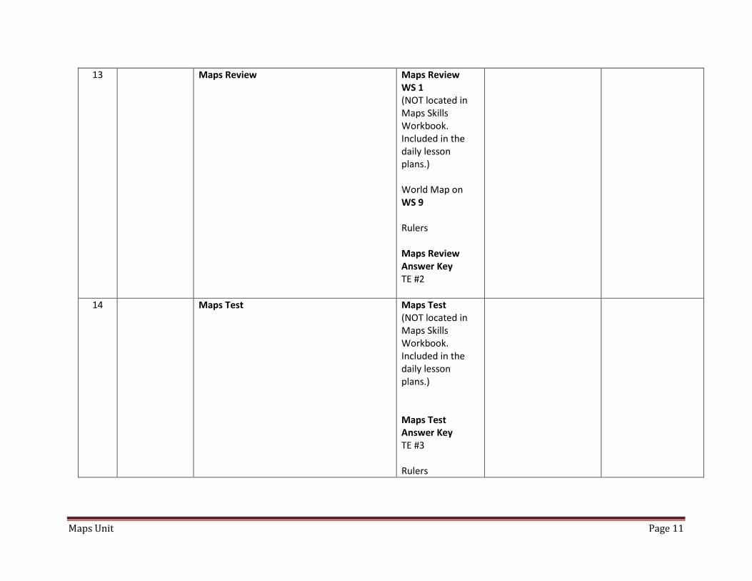
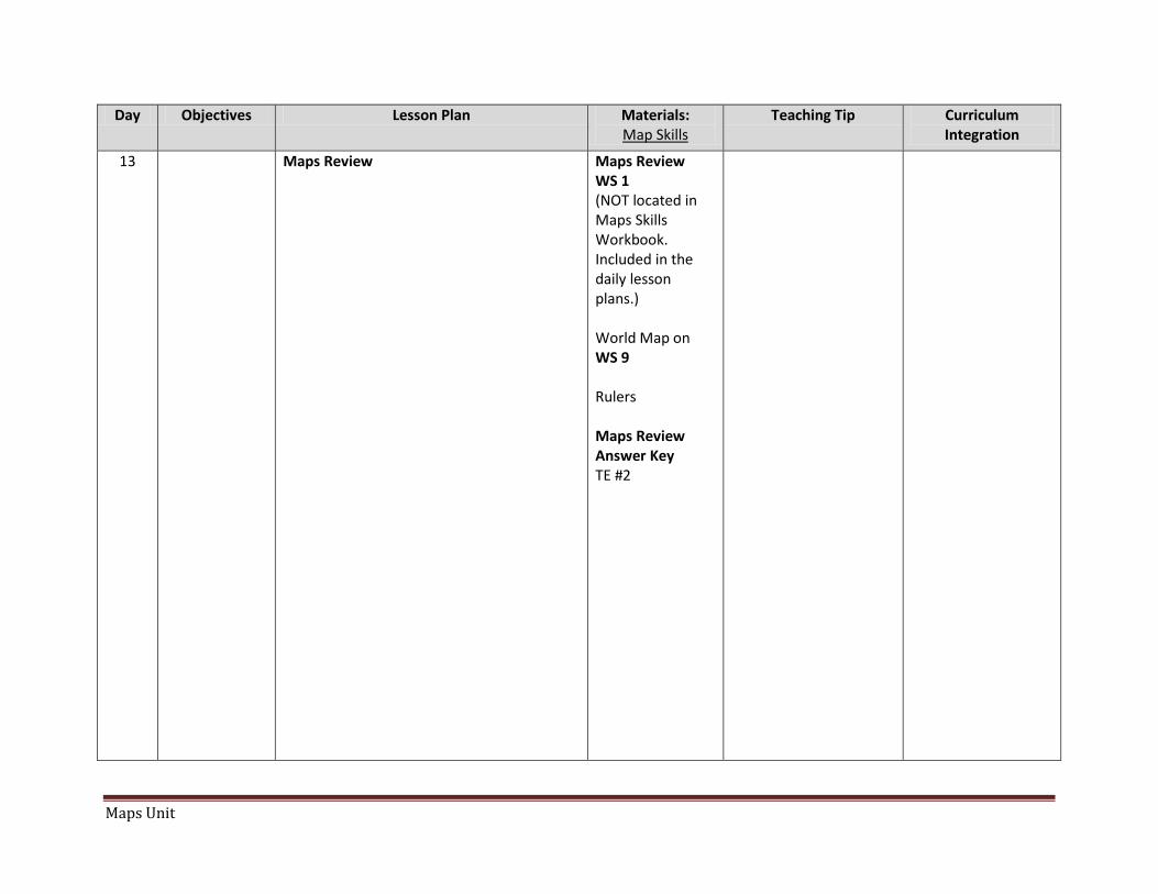
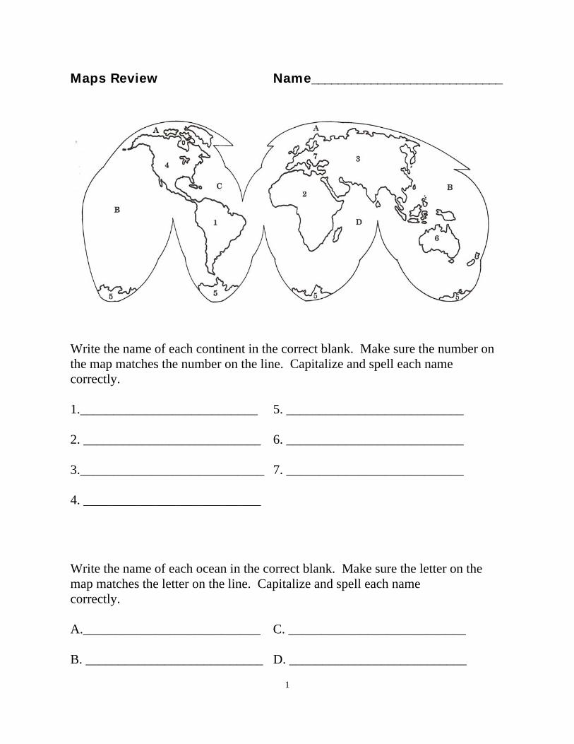
13 Maps Review Maps Review WS 1 (NOT located in Maps Skills Workbook. Included in the daily lesson plans.) World Map on WS 9 Rulers Maps Review Answer Key TE #2
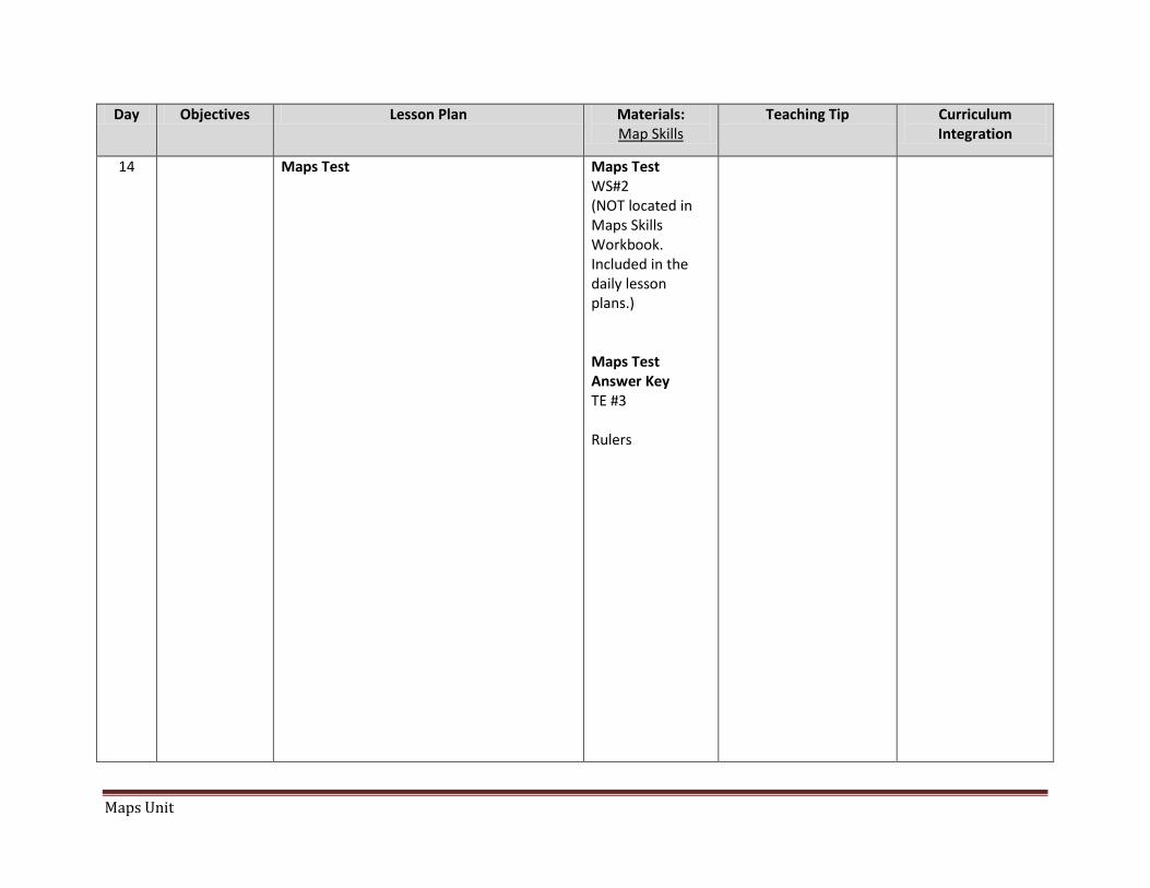
14 Maps Test Maps Test (NOT located in Maps Skills Workbook. Included in the daily lesson plans.) Maps Test Answer Key TE #3 Rulers
Maps Unit
Day Objectives Lesson Plan Materials: Map Skills
Teaching Tip Curriculum Integration
1 Reviewing map skills TE Page #2 Students complete WS 3, 4 & 5
WS 3, 4, 5 Colored pencils
Use when teaching classroom procedures the first week. IE How to pass out papers, seat work, raising hand, etc.
Maps Unit
Day Objectives Lesson Plan Materials: Map Skills
Teaching Tip Curriculum Integration
2 Locate and label the continents and oceans on a world map.
TE Page # 6 Students complete blank map on WS 7 using map on WS 9. EXTENSION: WS 8 has added practice if time permits or use for homework.
WS 7 & 9 Do not copy back to back. Students need to look at both WS at the same time. Also, make extra copies of page 7 for students who finish early for cutting out & making a globe. Copy page 9 on index paper and have students keep. They will need this map to complete the review at the end of the unit. Colored pencils Wall Map Globe WS 8 if time permits or for homework.
Explain to students there are not two Pacific Oceans as implied on the worksheet. Cut out map on WS 7 and form it into a globe using tape. Be sure to point out that the numbers on the continents & oceans must match the numbered blanks (#1 South America). Answers must be spelled correctly and capitalized.
Capitalization of proper nouns Make oceans & continents spelling words.
Maps Unit
Day Objectives Lesson Plan Materials: Map Skills
Teaching Tip Curriculum Integration
3 Locate and label the four hemispheres on a world map.
TE Page #6 (“Teaching Suggestions” #5) Students complete WS 10 & 11
WS 10 & 11 (Do not copy back to back. Students need to look at both WS at the same time.) Globe
Answers must be spelled correctly & capitalized.
Capitalization of proper nouns.
Maps Unit
Day Objectives Lesson Plan Materials: Map Skills
Teaching Tip Curriculum Integration
4 Identify and use cardinal directions.
TE Page #20 Students complete WS 21 and WS 23 EXTENSION: Use classroom direction signs to play “4 Corners” in the classroom. One student is blindfolded, everyone goes to a different corner (direction), the blindfolded student must call out the direction and point to it, and those students sit down. Play until only one player is left. “Simon Says” using the directions. For example, “Simon says point to the north.”
WS 21 & 23 Direction signs (North, South, East & West) TE #1 Compass
The WS does not take very long. Show students how to use a compass. Find north, south, east & west in your classroom. Place the direction signs in the proper place.
WS 22 is very difficult for students. The wording of the questions is awkward. This would be a good lesson to reinforce classroom management strategies on what to do when you are stumped and when you need to wait for help.
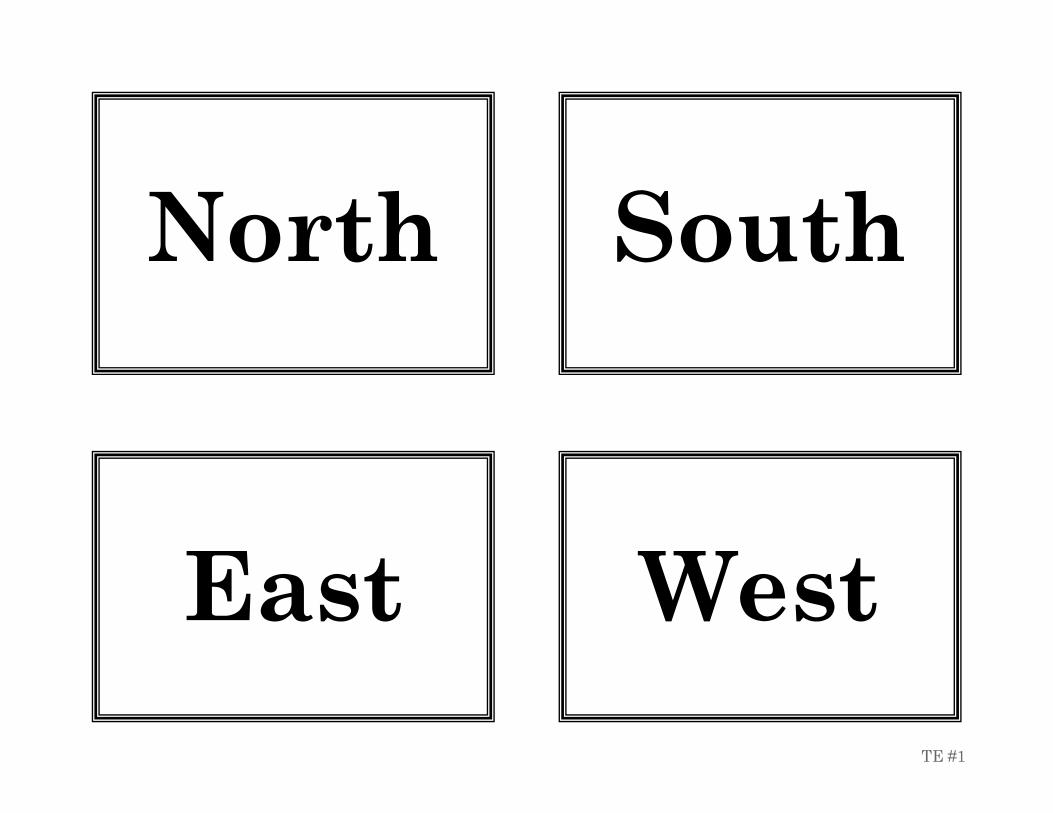
North
South
East
West
TE #1
Maps Unit
Day Objectives Lesson Plan Materials: Map Skills
Teaching Tip Curriculum Integration
5 Identify and use intermediate directions on a compass rose.
TE Page #24 Students complete WS 25 & 27 EXTENSION: See “Additional Activities” #2 on TE Page #24. WS 26 is very difficult for students. The wording of the questions is awkward.
WS 25 & 27
Explain to students that the top of the paper is always north and the bottom is always south. The wording of the questions on WS 25 is difficult for the students. You may need to do several of them together as a class.
Maps Unit
Day Objectives Lesson Plan Materials: Map Skills
Teaching Tip Curriculum Integration
6 Apply the use of a key/legend on a map.
TE Page #28 & #32 Students complete WS 30 & 33 EXTENSION: See “Additional Activities” on TE 28 & 32.
WS 30 & 33
Explain to students that when a question asks about what is north of the street, it means the entire street, not just the section above the street name.
Capitalization of proper nouns.
Maps Unit
Day Objectives Lesson Plan Materials: Map Skills
Teaching Tip Curriculum Integration
7 Apply scale by calculating distance on a map.
TE Page #36 Students complete WS 37 & 38 EXTENSION: See “Additional Activities” #1 on TE 24
WS 37 & 38 Overhead ruler Ruler for each student
Most rulers do not start at the edge of the ruler. Students need to know to start measuring from the line, not the end of the ruler. Distance is not always exact on copies. Students need to know to go to the closest benchmark when measuring. WS 38 will use a fraction of an inch when measuring scale. Go over question #2 together.
How to measure using a ruler. How to measure fractions of an inch. Capitalization of proper nouns.
Maps Unit
Day Objectives Lesson Plan Materials: Map Skills
Teaching Tip Curriculum Integration
8 Math
Lesson
WS 43 - 47 These WS reinforce math concept for coordinate grids.
Maps Unit
Day Objectives Lesson Plan Materials: Map Skills
Teaching Tip Curriculum Integration
9 Locate and label the equator on a map. Apply the use of lines of latitude to determine location on a map.
TE Page #48 Students complete WS 49
WS 49 Colored pencils
Reinforce the unit of measurement is in degrees. It is in the directions at the top of WS 49, but students overlook this. Reinforce that the numbers are the same, but it is the north and south of the equator that is important.
Math: Use a protractor to show how the degrees are measured to create lines of latitude.
Maps Unit
Day Objectives Lesson Plan Materials: Map Skills
Teaching Tip Curriculum Integration
10 Apply the use of lines of latitude to determine location on a map.
More practice Students complete WS 52
WS 52 Reteach that the boundaries of the states are the dashed lines. It may be helpful to outline those in colored pencil before beginning. Reinforce that the straight borders fall on lines of latitude; while the crooked borders are created by rivers or the Pacific Ocean’s coastline. Reteach that the city names are represented by dots, and the state names are in bold. It is helpful to trace the lines of latitude with a highlighter before beginning. Discuss where the unlabeled lines of latitude would be placed on the map.
Capitalization of proper nouns.
Maps Unit
Day Objectives Lesson Plan Materials: Map Skills
Teaching Tip Curriculum Integration
11 Locate and label the prime meridian on a map. Apply the use of lines of longitude to determine location on a map.
TE Page #54 Students complete WS 55 & 57 EXTENSION: WS 56 has added practice, if time permits, or use for homework.
WS 55 & 57
Be sure the students are connecting the meridians of the map at the bottom of WS 55 at the two poles. They want to make them parallel like the lines of latitude.
Capitalization of proper nouns.
Maps Unit
Day Objectives Lesson Plan Materials: Map Skills
Teaching Tip Curriculum Integration
12 Apply the use of lines of latitude and longitude to determine location on a map.
TE Page #60 Students complete WS 66 EXTENSION: WS 62 has added practice and is challenging. Tell students to check off numbers as they draw the lines on the map so they don’t get lost while doing the activity. Too difficult to use for homework.
WS 66 WS 62 if time permits.
Point out to students that not all states show a city and that the states are abbreviated. Remind the students that the dot represents the closest city. (See San Francisco & San José.) Teach students how to estimate unlabeled lines of longitude and latitude in between the labeled lines. Use colored pencils to draw in unlabeled lines of latitude and longitude.
Capitalization of proper nouns.
Maps Unit
Day Objectives Lesson Plan Materials: Map Skills
Teaching Tip Curriculum Integration
13 Maps Review Maps Review WS 1 (NOT located in Maps Skills Workbook. Included in the daily lesson plans.) World Map on WS 9 Rulers Maps Review Answer Key TE #2
1
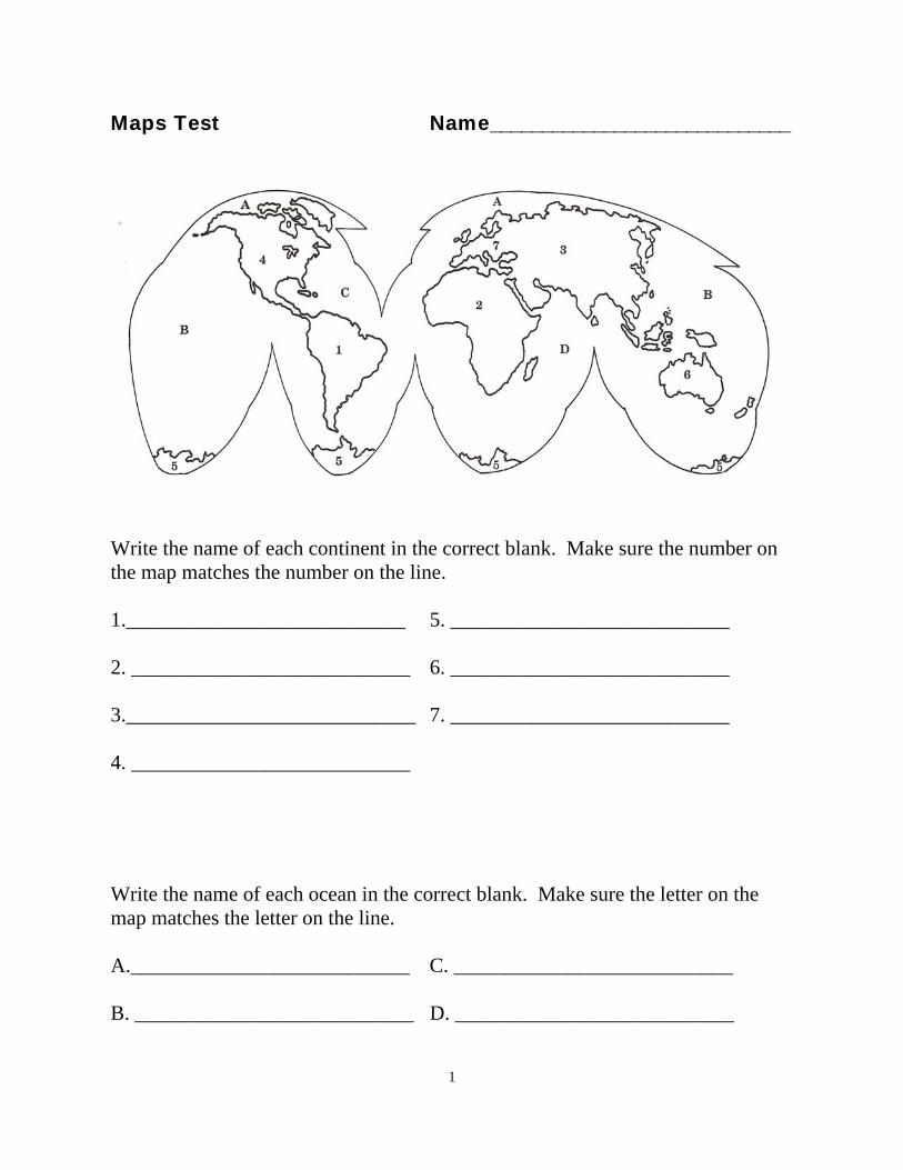
Maps Review Name_____________________________
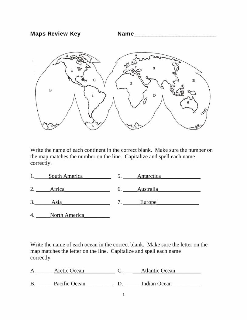
Write the name of each continent in the correct blank. Make sure the number on the map matches the number on the line. Capitalize and spell each name correctly. 1.___________________________ 5. ___________________________ 2. ___________________________ 6. ___________________________ 3.____________________________ 7. ___________________________ 4. ___________________________
Write the name of each ocean in the correct blank. Make sure the letter on the map matches the letter on the line. Capitalize and spell each name correctly. A.___________________________ C. ___________________________ B. ___________________________ D. ___________________________
2
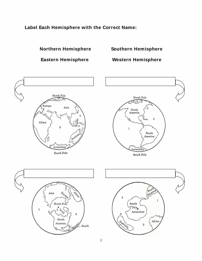
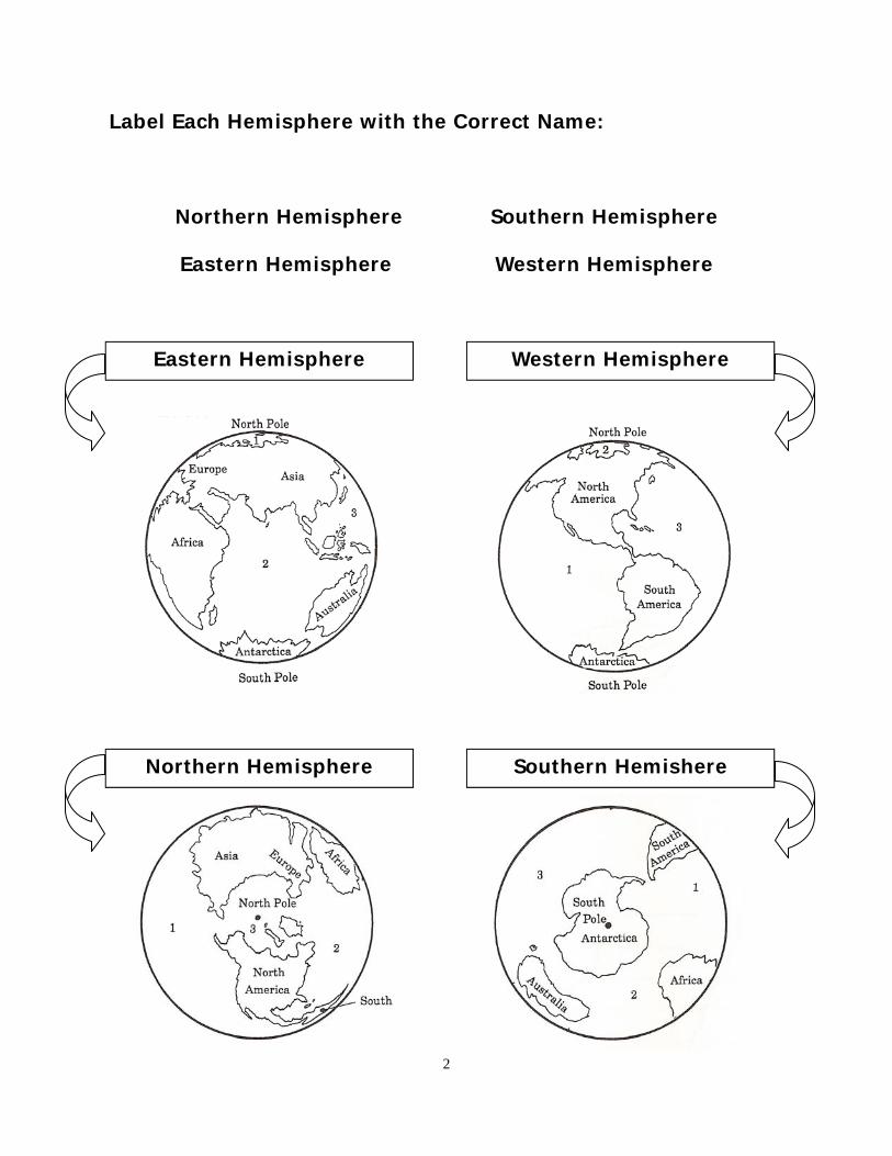
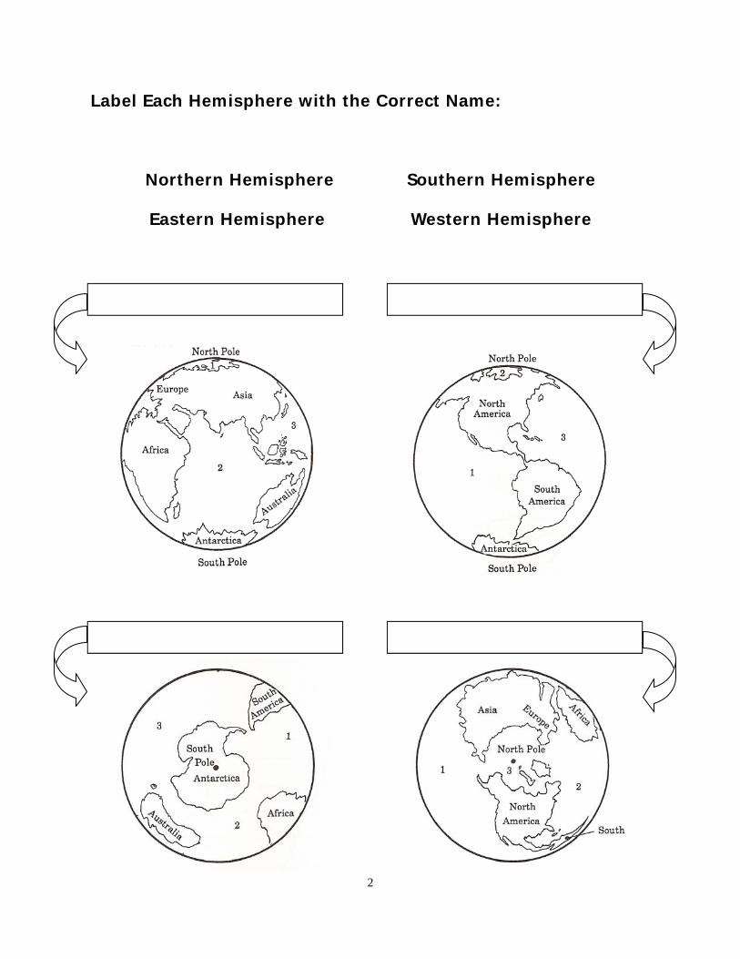
Label Each Hemisphere with the Correct Name:
Northern Hemisphere Southern Hemisphere
Eastern Hemisphere Western Hemisphere
3
1.
2. 3. 4. 5.
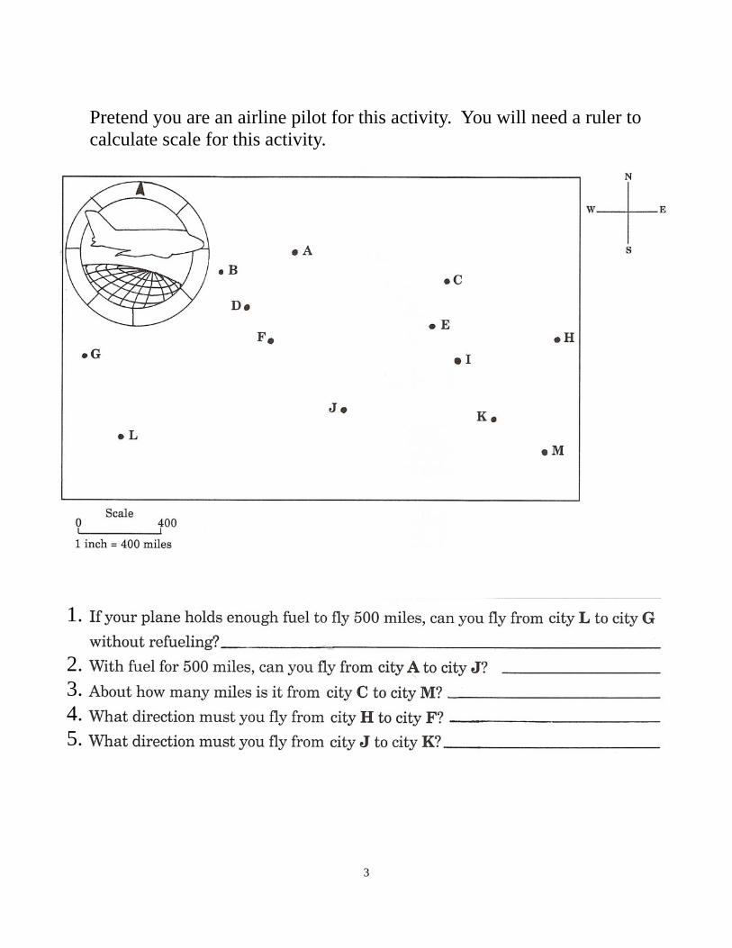
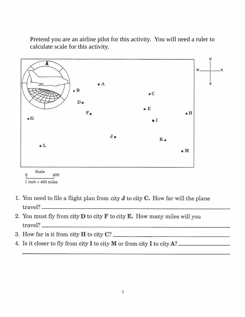
Pretend you are an airline pilot for this activity. You will need a ruler to calculate scale for this activity.

4
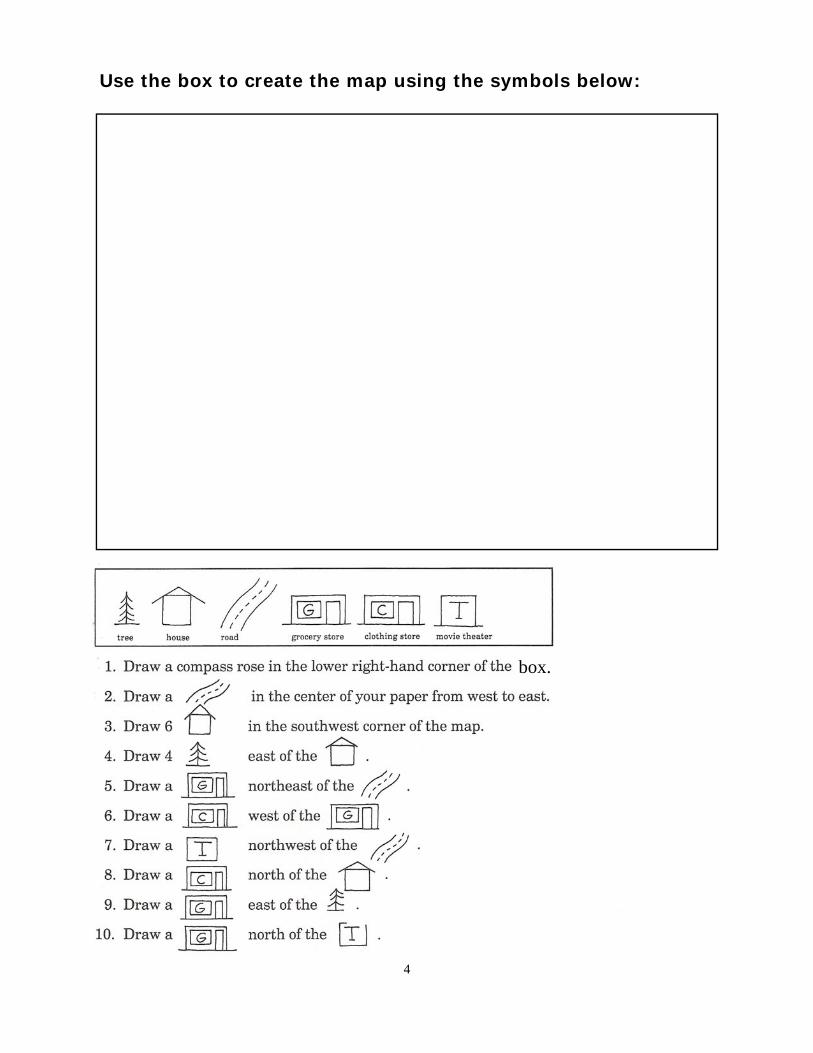
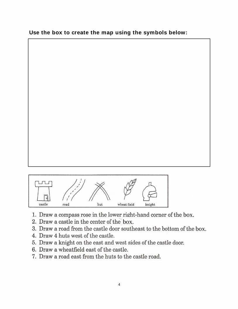
Use the box to create the map using the symbols below:
box.
5
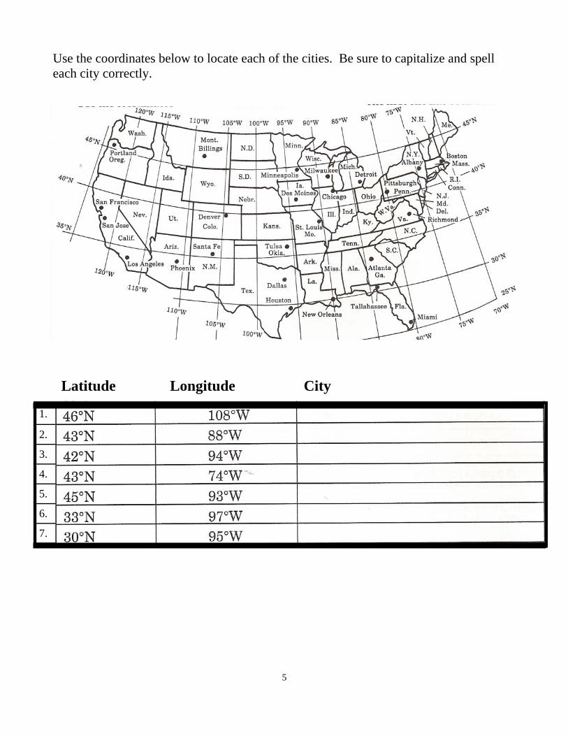
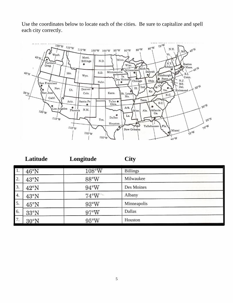
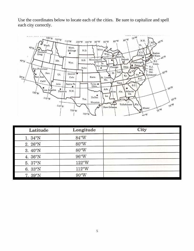
Use the coordinates below to locate each of the cities. Be sure to capitalize and spell each city correctly.
1.
2.
3.
4.
5.
6.
7.
Latitude Longitude City
1
Maps Review Key Name_____________________________
Write the name of each continent in the correct blank. Make sure the number on the map matches the number on the line. Capitalize and spell each name correctly. 1._____South America__________ 5. _____Antarctica______________ 2. _____Africa________________ 6. _____Australia_______________ 3.______Asia_________________ 7. ______Europe_______________ 4. _____North America_________
Write the name of each ocean in the correct blank. Make sure the letter on the map matches the letter on the line. Capitalize and spell each name correctly. A. ______Arctic Ocean___________ C. ______Atlantic Ocean_________ B. ______Pacific Ocean__________ D. ______Indian Ocean__________
2
Label Each Hemisphere with the Correct Name:
Northern Hemisphere Southern Hemisphere
Eastern Hemisphere Western Hemisphere
Western Hemisphere
Southern Hemishere Northern Hemisphere
Eastern Hemisphere
3
1.
2. 3. 4. 5.
Pretend you are an airline pilot for this activity. You will need a ruler to calculate scale for this activity.
Yes
No
Answer: between 800-1,000 miles
West
East
4
Use the box to create the map using the symbols below:
box.
5
Use the coordinates below to locate each of the cities. Be sure to capitalize and spell each city correctly.
1.
2.
3.
4.
5.
6.
7.
Latitude Longitude City
Billings
Milwaukee
Des Moines
Albany
Houston
Dallas
Minneapolis
Maps Unit
Day Objectives Lesson Plan Materials: Map Skills
Teaching Tip Curriculum Integration
14 Maps Test Maps Test WS#2 (NOT located in Maps Skills Workbook. Included in the daily lesson plans.) Maps Test Answer Key TE #3 Rulers
1
Maps Chapter Test Name_____________________________ Maps Test Name_____________________________
Write the name of each continent in the correct blank. Make sure the number on the map matches the number on the line. 1.___________________________ 5. ___________________________ 2. ___________________________ 6. ___________________________ 3.____________________________ 7. ___________________________ 4. ___________________________
Write the name of each ocean in the correct blank. Make sure the letter on the map matches the letter on the line. A.___________________________ C. ___________________________ B. ___________________________ D. ___________________________
2
Label Each Hemisphere with the Correct Name:
Northern Hemisphere Southern Hemisphere
Eastern Hemisphere Western Hemisphere
3
Pretend you are an airline pilot for this activity. You will need a ruler to calculate scale for this activity.
4
Use the box to create the map using the symbols below:
box. box.
box.
5
Use the coordinates below to locate each of the cities. Be sure to capitalize and spell each city correctly.
1
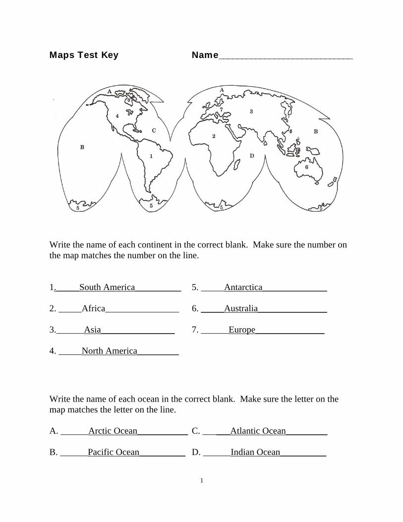
Maps Chapter Test Name_____________________________ Maps Test Key Name_____________________________
Write the name of each continent in the correct blank. Make sure the number on the map matches the number on the line. 1._____South America__________ 5. _____Antarctica______________ 2. _____Africa________________ 6. _____Australia_______________ 3.______Asia________________ 7. ______Europe_______________ 4. _____North America_________
Write the name of each ocean in the correct blank. Make sure the letter on the map matches the letter on the line. A. ______Arctic Ocean___________ C. ______Atlantic Ocean_________ B. ______Pacific Ocean__________ D. ______Indian Ocean__________
2
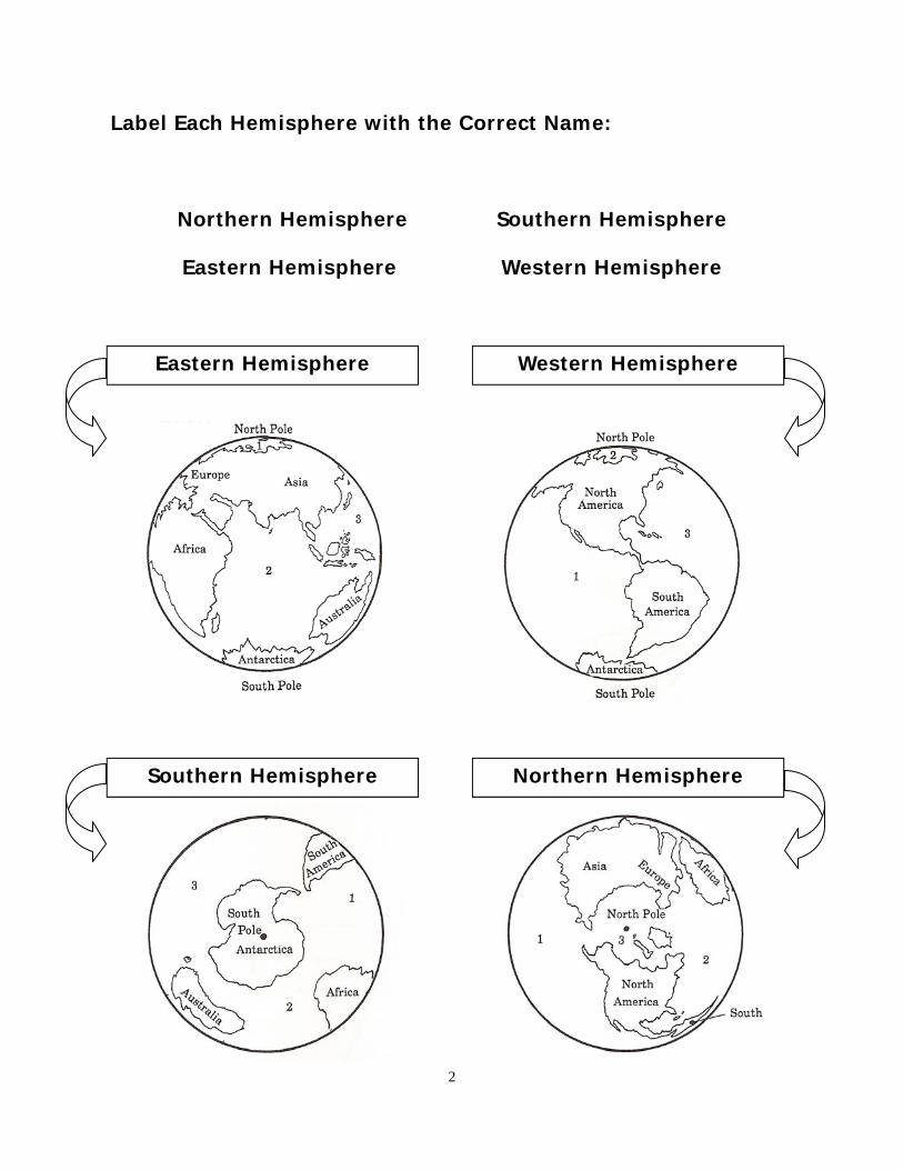
Label Each Hemisphere with the Correct Name:
Northern Hemisphere Southern Hemisphere
Eastern Hemisphere Western Hemisphere
Western Hemisphere
Northern Hemisphere Southern Hemisphere
Eastern Hemisphere
3
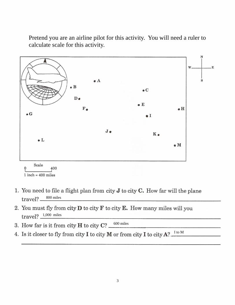
Pretend you are an airline pilot for this activity. You will need a ruler to calculate scale for this activity.
800 miles
1,000 miles
600 miles
I to M

4
Use the box to create the map using the symbols below:
box. box.
box.
5
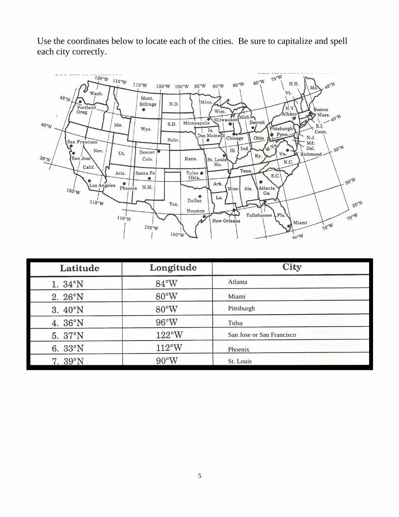
Use the coordinates below to locate each of the cities. Be sure to capitalize and spell each city correctly.
St. Louis
Phoenix
San Jose or San Francisco
Tulsa
Pittsburgh
Miami
Atlanta