Embed Size (px)
Citation preview

Office for Coastal Management
Mapping & Visualizing Lake Level Changes for the U.S. Great
Lakes
Doug MarcyBrandon Krumwiede
NOAA Office for Coastal Management
June 23, 2016
Office for Coastal Management
Overview
• Climate and Water Level Overview
• Needs and Requirements
• Data Access and Application
• Updates in Progress

Office for Coastal Management
The Great Lakes ClimateLake Effects Have Significant Impact on the
Regional Climate System
Superior
Huron
Michigan
Erie
Ontario

Office for Coastal Management
Many Climate Variables

Office for Coastal Management
Water In Water Out
The Hydrologic Cycle
Net Basin Supply (NBS)
NBS = Overlake precipitation – Overlake evaporation + runoff from land
+ groundwater from land

Office for Coastal Management
Lake Levels?
Office for Coastal Management
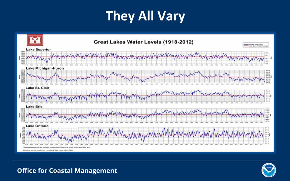
They All Vary

Office for Coastal Management
National Climate Assessment• The Second National Climate Assessment predicted
significant drops in Great Lakes lake levels by 2100.
• Previous studies overestimated the amount of
evapotransporation, and the Third National Climate
Assessment predicts a slight decrease or even a slight rise
in water levels.
• Recent climate studies, along with the large spread in existing
modeling results, indicate that projections of Great Lakes
water levels represent evolving research and are still subject
to considerable uncertainty.

Office for Coastal Management
Low Water Impacts• Impacts shipping, power generation, tourism,
fishing, the ecology of the Great Lake ecosystem, shoreline property owners, and recreational boating.
• During low level periods, lake carriers transporting iron ore, coal, grain, and other commodities are forced to carry fewer goods.
• Also, as water levels recede, marinas have fewer slips to sell to boaters and often must dredge boat slips, channels, and harbor to accommodate boater needs, costing millions.
But lower water can be advantageous for expansion of wetland habitats

Office for Coastal Management
High Water Impacts
Enhanced seiche effect causing bluff, beach, and lake-bed erosion, coastal flooding, and sediment transport, which have cascading consequences for shoreline hazards, water quality, and habitats.
Understanding the nature and distribution of impacts associated with lake-level change is critical for targeting watersheds, habitats, and species for Great Lakes Restoration Initiative project funding.

Office for Coastal Management
What is the NOAA Lake Level Viewer?
• Work on the Lake Level Viewer began over 3 years ago
• First official release in November 2014
• Funded by the Great Lakes Restoration Initiative
• Fills a critical information data gap:– 40% of Coastal Storms Program survey respondents said
current data on future lake level changes are inadequate– Only 26% said existing tools to work with or visualize
these data are adequateSource: 2013 Shoreline Change Workshop: Perspectives on the Great Lakes Survey

Office for Coastal Management
What is the NOAA Lake Level Viewer?
Use this data...

Office for Coastal Management
What is the NOAA Lake Level Viewer?
… to visualize the impacts
April 1986

Office for Coastal Management
Lake Level Viewer Requirements
•Use best available, high accuracy topo/bathy Lidar data to build a seamless digital elevation model (DEM) for Great Lakes coastline
•Map lake levels below and above each lake’s long-term average level to visualize the impacts of both flooding and low lake levels
•Develop photo simulations at local landmarks to see impacts
• Link visualizations to historical water levels (water level dashboard) for context
•Define elevation data gaps for future collection efforts
•Access map services and download elevation and lake level data

Office for Coastal Management
Use Best Available Topo/Bathy Lidarwww.csc.noaa.gov/inventory

Office for Coastal Management
Topo/Bathy LidarVery Efficient vs. Ship-Based Methods

Office for Coastal Management
But Has Some Challenges

Office for Coastal Management
Digital Elevation Models From Topo/Bathy Lidar
Office for Coastal Management
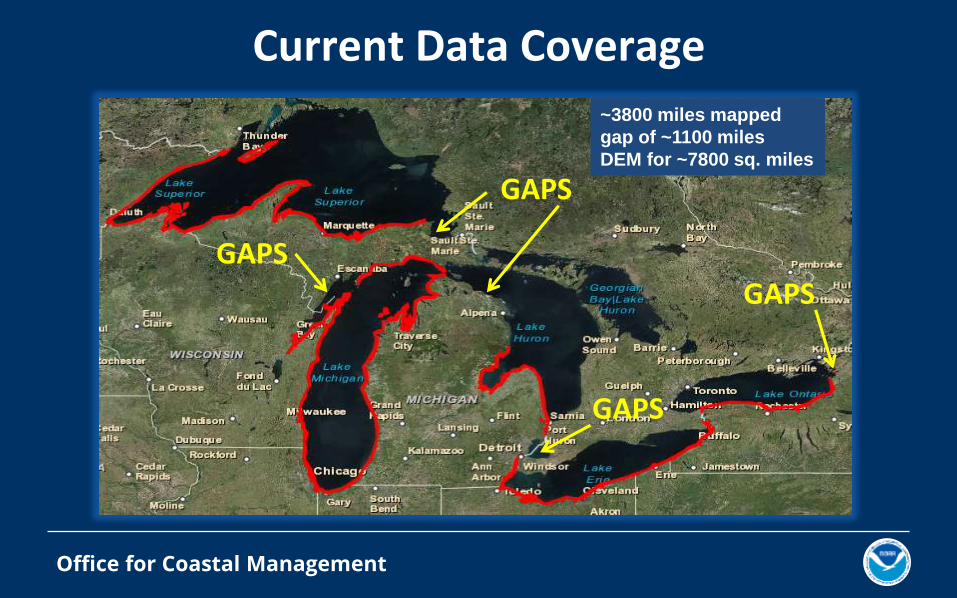
Current Data Coverage
GAPS
~3800 miles mapped
gap of ~1100 miles
DEM for ~7800 sq. miles
GAPS
GAPS
GAPS

Office for Coastal Management
Gaps Within Coverage
Topography with No Bathymetry (much more common)
Bathymetry with No Topography (much less common)

Office for Coastal Management
Gaps in Harbors
Flooding Information, but missing water depth information in some harbors

Office for Coastal Management
Data Access and Application
Lots of Layers Available
• Lake level change layers
• Uncertainty layers
• Socioeconomic layers
• Conditioned DEMs
Lots of Ways to Distribute
• Raster geodatabases via HTTP
• ESRI Representational State Transfer (REST) map services
• Web Map Services (WMS)

Office for Coastal Management
Updates in Progress
Office for Coastal Management
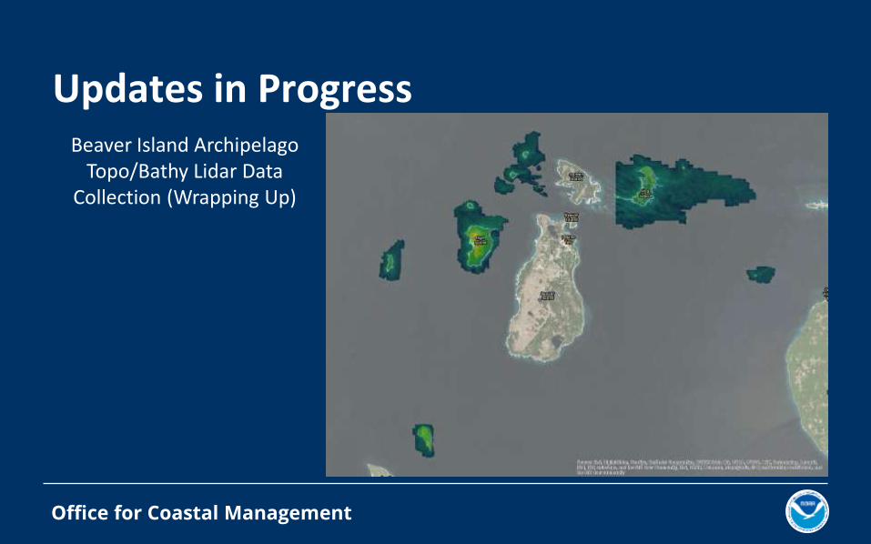
Updates in ProgressBeaver Island Archipelago
Topo/Bathy Lidar Data Collection (Wrapping Up)

Office for Coastal Management
Updates in ProgressCurrent Lake Level Viewer

Office for Coastal Management
Updates in ProgressUpdated Lake Level Viewer
State Topo LidarBathy Lidar
USACE Dredge Survey

Office for Coastal Management
Updates in Progress
Currently undergoing QA/QC
Office for Coastal Management
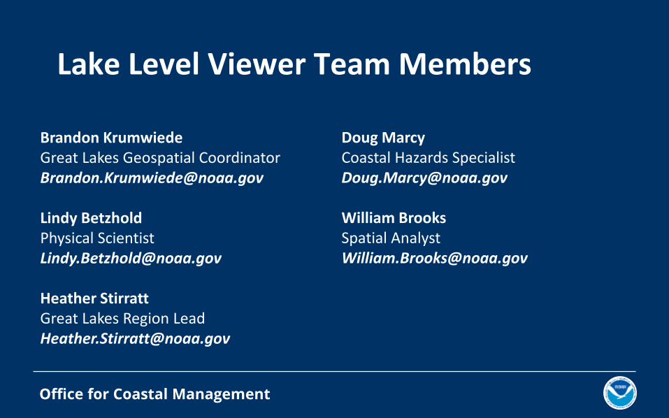
Brandon KrumwiedeGreat Lakes Geospatial [email protected]
Lindy BetzholdPhysical [email protected]
Heather StirrattGreat Lakes Region [email protected]
Doug MarcyCoastal Hazards [email protected]
William BrooksSpatial [email protected]
Lake Level Viewer Team Members

Office for Coastal Management
ResourcesNOAA Office for Coastal Management Digital Coast
coast.noaa.gov/digitalcoast
Lake Level Viewercoast.noaa.gov/digitalcoast/tools/llv AND coast.noaa.gov/llv
US Interagency Elevation Inventory
coast.noaa.gov/inventory/
CanVis
coast.noaa.gov/digitalcoast/tools/canvis
NOAA GLERL Water Level Dashboard
www.glerl.noaa.gov/data/dashboard/GLWLD.html


![[Challenge:Future] Eco mapping : Olleh Roads in Lake Bikal](https://img.pdfslide.us/doc/110x75/58e97f211a28aba6498b4dd3/challengefuture-eco-mapping-olleh-roads-in-lake-bikal.jpg)
