Embed Size (px)
Citation preview

Version 3.4
While reasonable efforts have been made to ensure that the contents of this publication are factually correct, the Commonwealth does not accept responsibility for the accuracy or completeness of the contents, and shall not be liable for any loss or damage that may be occasioned directly or indirectly through the use of, or reliance on, the contents of this publication.
Mapping tool instructions
The following instructions will explain how to draw polygon areas (borders around a specific land area)
for a project using Google Maps. Existing polygons can also be loaded as an existing Google Earth
(KML) file.
Browser Compatibility: This mapping tool is known to work with the following browsers: - Internet Explorer version 10 and above (Internet Explorer’s Compatibility View is not supported) - Chrome version 36 and above - Firefox version 17 and above If you experience any issues please ensure that you are using the latest browser version.
Contents
1. Launch the Mapping Tool ................................................................................................... 2
2. Navigate to the general area of interest - using Search or the Zoom and Pan functions ..... 2
3. Drawing a polygon area or multiple areas ........................................................................... 3
4. Modifying polygon areas and clearing the map ................................................................... 5
5. Saving mapping .................................................................................................................. 6
6. Saving an image of your map………………………………………………………………….....8
7. Advanced Features………………………………………………………………………………...9
8. More information .......................................................................................................... …11
2
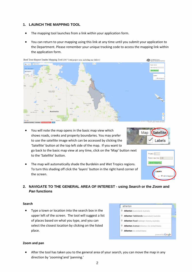
1. LAUNCH THE MAPPING TOOL
The mapping tool launches from a link within your application form.
You can return to your mapping using this link at any time until you submit your application to
the Department. Please remember your unique tracking code to access the mapping link within
the application form.
You will note the map opens in the basic map view which
shows roads, creeks and property boundaries. You may prefer
to use the satellite image which can be accessed by clicking the
‘Satellite’ button at the top left side of the map. If you want to
go back to the basic map view at any time, click on the ‘Map’ button next
to the ‘Satellite’ button.
The map will automatically shade the Burdekin and Wet Tropics regions.
To turn this shading off click the ‘layers’ button in the right hand corner of
the screen.
2. NAVIGATE TO THE GENERAL AREA OF INTEREST - using Search or the Zoom and
Pan functions
Search
Type a town or location into the search box in the
upper left of the screen. The tool will suggest a list
of places based on what you type, and you can
select the closest location by clicking on the listed
place.
Zoom and pan
After the tool has taken you to the general area of your search, you can move the map in any
direction by ‘zooming’and ‘panning.’
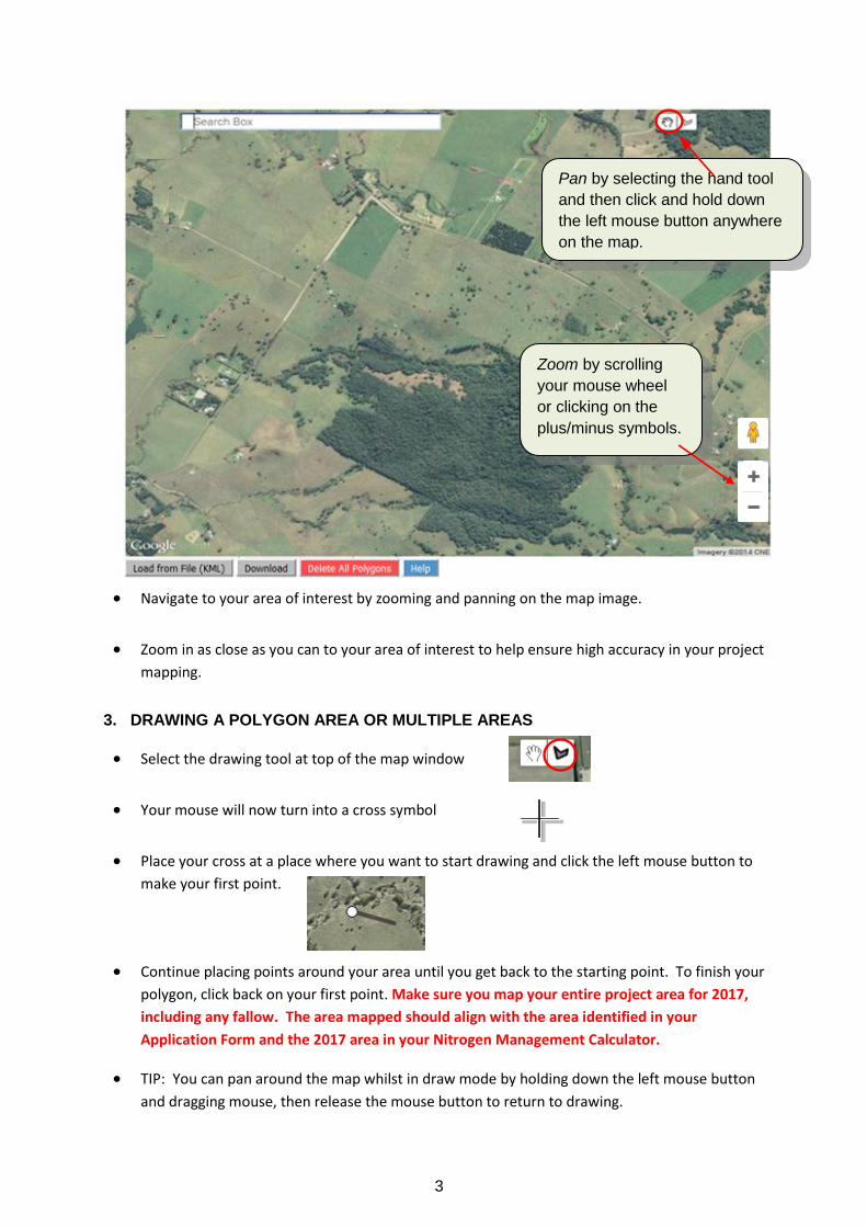
3
Navigate to your area of interest by zooming and panning on the map image.
Zoom in as close as you can to your area of interest to help ensure high accuracy in your project
mapping.
3. DRAWING A POLYGON AREA OR MULTIPLE AREAS
Select the drawing tool at top of the map window
Your mouse will now turn into a cross symbol
Place your cross at a place where you want to start drawing and click the left mouse button to
make your first point.
Continue placing points around your area until you get back to the starting point. To finish your
polygon, click back on your first point. Make sure you map your entire project area for 2017,
including any fallow. The area mapped should align with the area identified in your
Application Form and the 2017 area in your Nitrogen Management Calculator.
TIP: You can pan around the map whilst in draw mode by holding down the left mouse button
and dragging mouse, then release the mouse button to return to drawing.
Zoom by scrolling
your mouse wheel
or clicking on the
plus/minus symbols.
Pan by selecting the hand tool
and then click and hold down
the left mouse button anywhere
on the map.
4
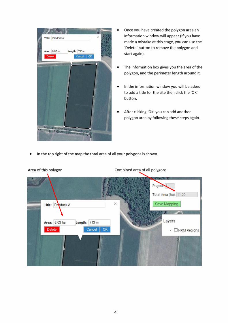
Once you have created the polygon area an
information window will appear (if you have
made a mistake at this stage, you can use the
‘Delete’ button to remove the polygon and
start again).
The information box gives you the area of the
polygon, and the perimeter length around it.
In the information window you will be asked
to add a title for the site then click the ‘OK’
button.
After clicking ‘OK’ you can add another
polygon area by following these steps again.
In the top right of the map the total area of all your polygons is shown.
Area of this polygon Combined area of all polygons
5
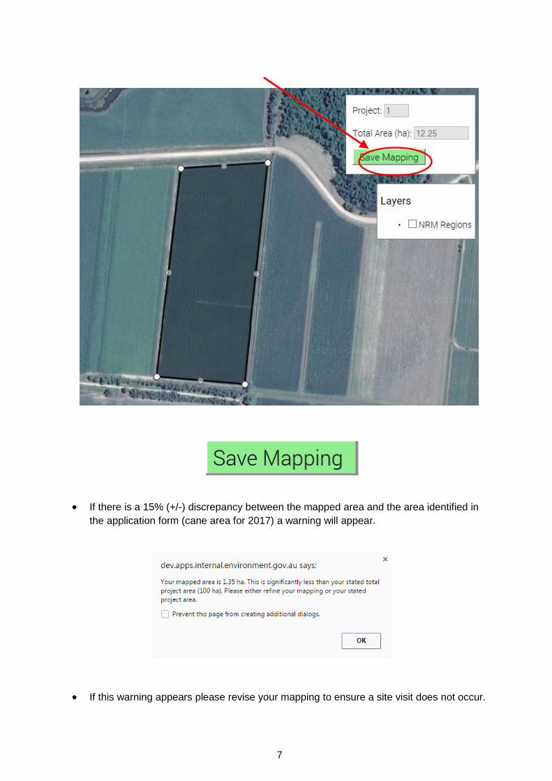
Click the ‘Save Mapping’ button in the top right of the screen to save your work. Once saved, the
map will be automatically submitted to the Department when you submit your application form.
You can return to the mapping tool to adjust your polygon areas at any time, until you formally
submit the form.
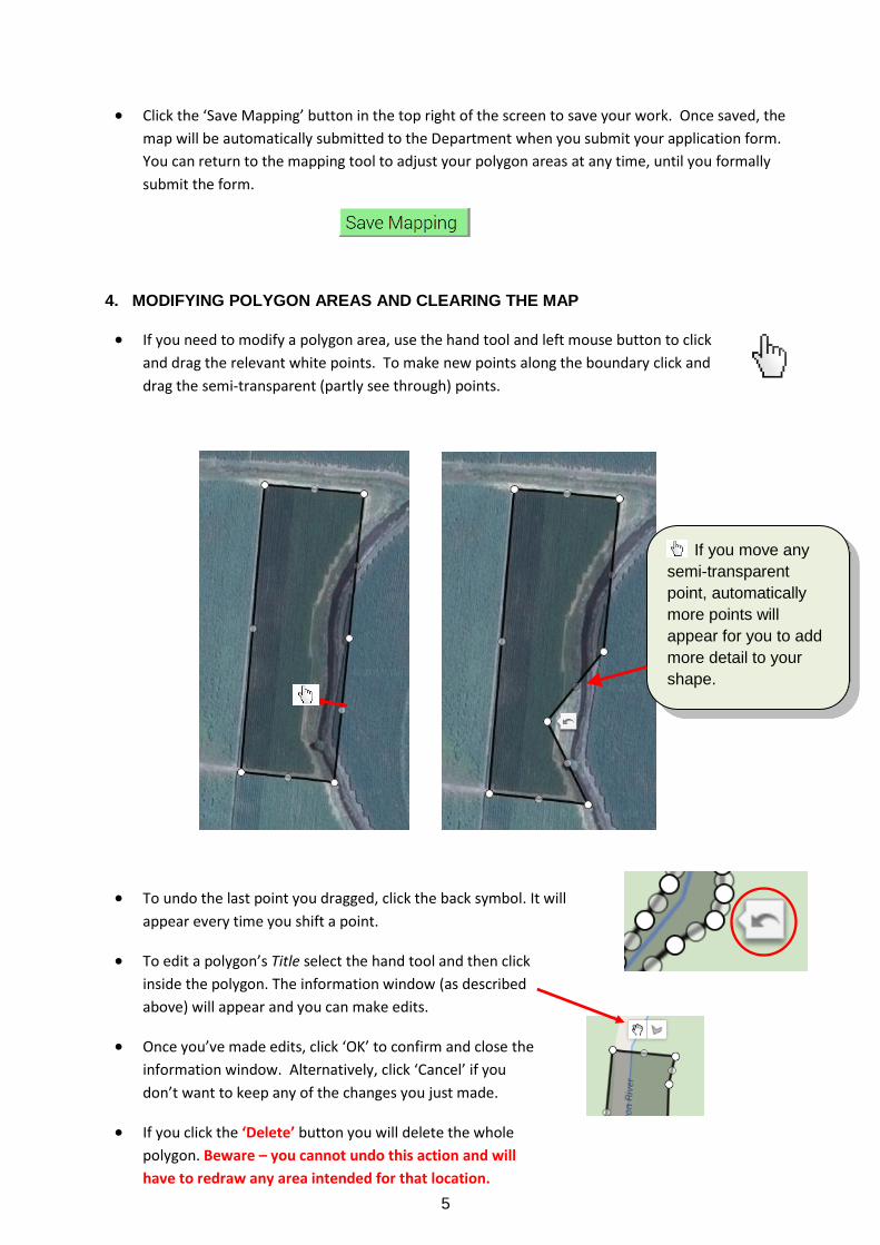
4. MODIFYING POLYGON AREAS AND CLEARING THE MAP
If you need to modify a polygon area, use the hand tool and left mouse button to click
and drag the relevant white points. To make new points along the boundary click and
drag the semi-transparent (partly see through) points.
To undo the last point you dragged, click the back symbol. It will
appear every time you shift a point.
To edit a polygon’s Title select the hand tool and then click
inside the polygon. The information window (as described
above) will appear and you can make edits.
Once you’ve made edits, click ‘OK’ to confirm and close the
information window. Alternatively, click ‘Cancel’ if you
don’t want to keep any of the changes you just made.
If you click the ‘Delete’ button you will delete the whole
polygon. Beware – you cannot undo this action and will
have to redraw any area intended for that location.
If you move any
semi-transparent
point, automatically
more points will
appear for you to add
more detail to your
shape.
6
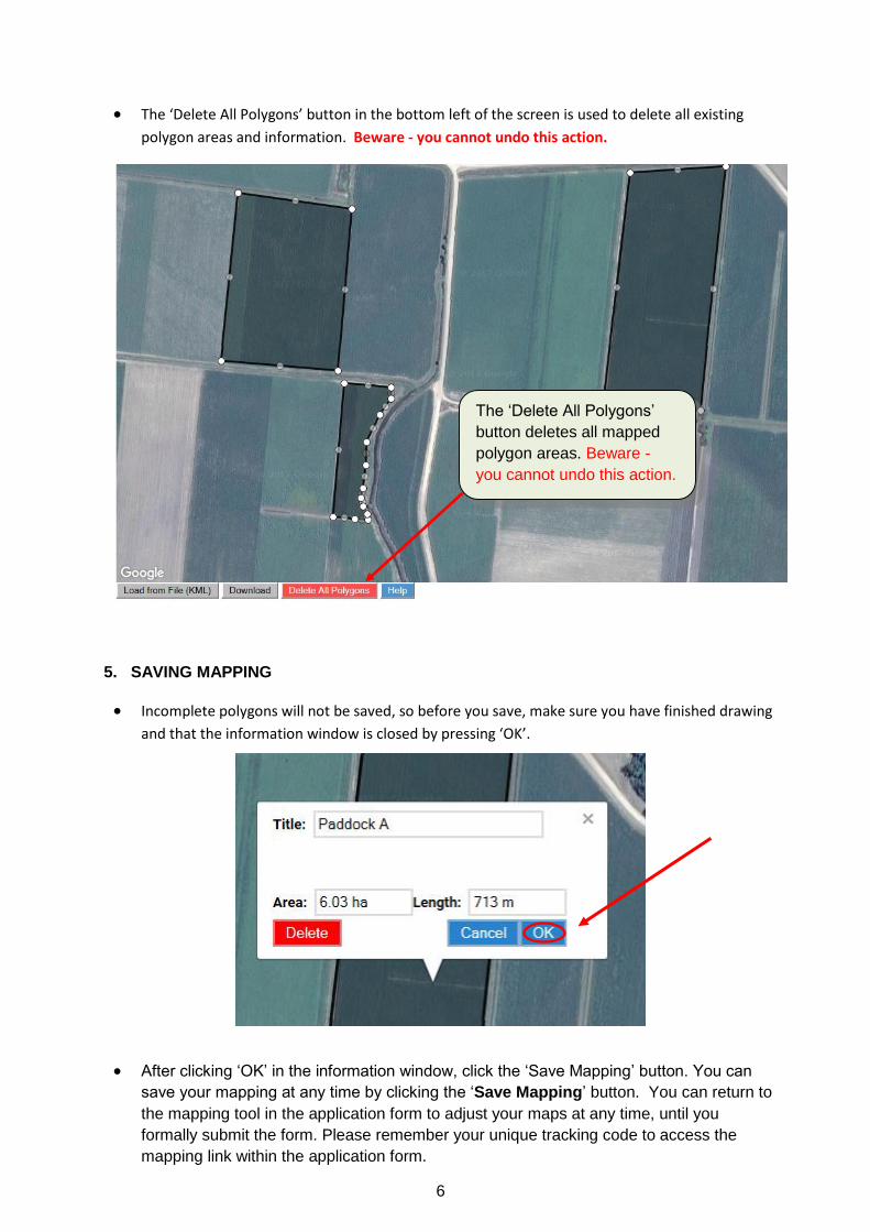
The ‘Delete All Polygons’ button in the bottom left of the screen is used to delete all existing
polygon areas and information. Beware - you cannot undo this action.
5. SAVING MAPPING
Incomplete polygons will not be saved, so before you save, make sure you have finished drawing
and that the information window is closed by pressing ‘OK’.
After clicking ‘OK’ in the information window, click the ‘Save Mapping’ button. You can
save your mapping at any time by clicking the ‘Save Mapping’ button. You can return to
the mapping tool in the application form to adjust your maps at any time, until you
formally submit the form. Please remember your unique tracking code to access the
mapping link within the application form.
The ‘Delete All Polygons’
button deletes all mapped
polygon areas. Beware -
you cannot undo this action.
7
If there is a 15% (+/-) discrepancy between the mapped area and the area identified in
the application form (cane area for 2017) a warning will appear.
If this warning appears please revise your mapping to ensure a site visit does not occur.
8
6. SAVING AN IMAGE OF YOUR MAP
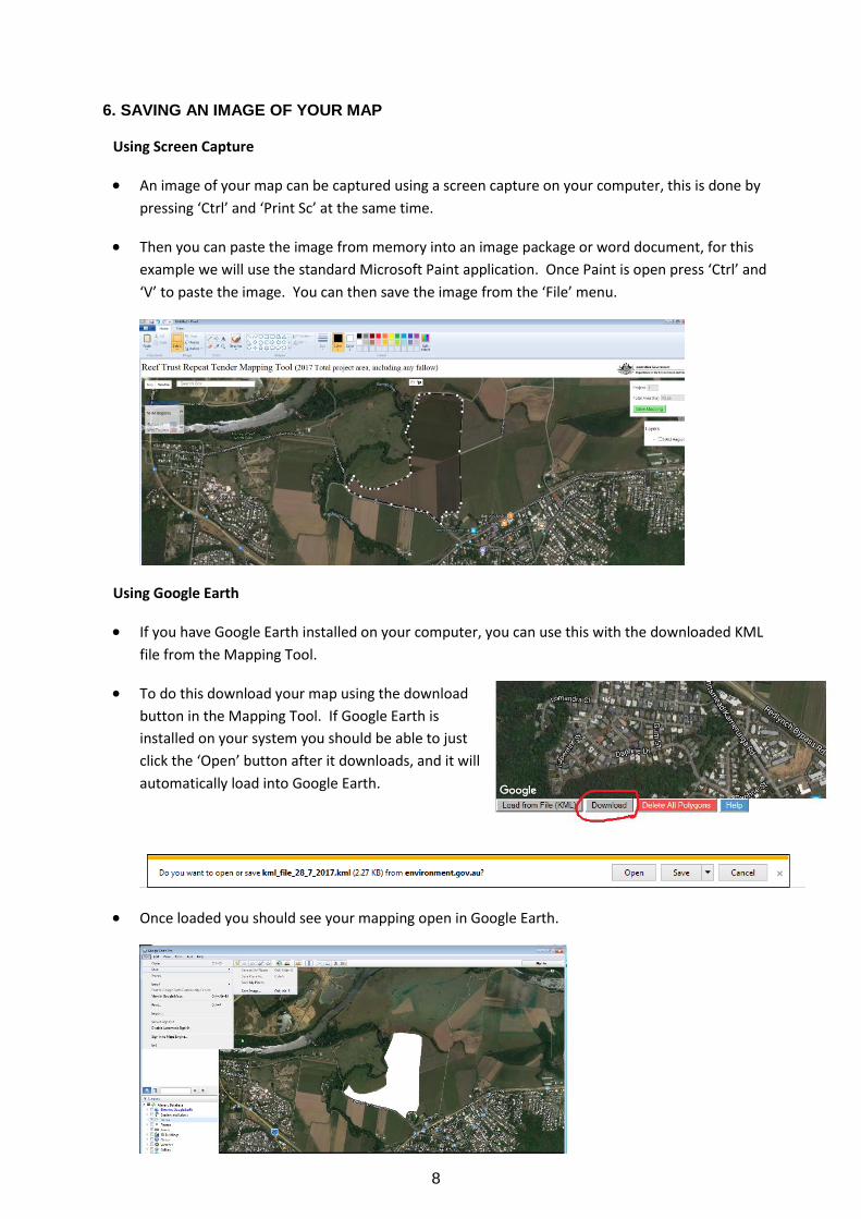
Using Screen Capture
An image of your map can be captured using a screen capture on your computer, this is done by
pressing ‘Ctrl’ and ‘Print Sc’ at the same time.
Then you can paste the image from memory into an image package or word document, for this
example we will use the standard Microsoft Paint application. Once Paint is open press ‘Ctrl’ and
‘V’ to paste the image. You can then save the image from the ‘File’ menu.
Using Google Earth
If you have Google Earth installed on your computer, you can use this with the downloaded KML
file from the Mapping Tool.
To do this download your map using the download
button in the Mapping Tool. If Google Earth is
installed on your system you should be able to just
click the ‘Open’ button after it downloads, and it will
automatically load into Google Earth.
Once loaded you should see your mapping open in Google Earth.

9
Then to save an image go to the ‘File’ menu, select ‘Save’ and then ‘Save Image’.
7. ADVANCED FEATURES
Loading Google Earth KML files
Note: 1. This feature is only available on Firefox browser versions 13 and above, or Internet
Explorer versions 10 and above. It should also work with most other browsers if they are
up to date.
2. Please make sure KML files only contain polygon areas.
3. Take care using this feature – if you load an existing KML file it will over-ride and clear all
existing mapping you have done using the tool.
4. For more information on Google Earth KML file see
(https://support.google.com/earth/answer/148118?hl=en)
If you already have a Google Earth KML file with polygon areas for your project, you can browse
to it using the ‘Load from File (KML)’ button in the bottom left of the screen.
IMPORTANT: To avoid losing any existing mapping when you load a KML (see point 3 above) you
should always load an existing KML file first and then add any new polygons as required, rather
than the other way around. If you have multiple KMLs that you wish to merge into one, before
loading it into the tool, you can do this within Google Earth Pro, which can be freely downloaded
at https://www.google.com.au/earth/download/gep/agree.html
Browse to a KML file on your file system and click ‘Open’ to load the KML file to the map.
10
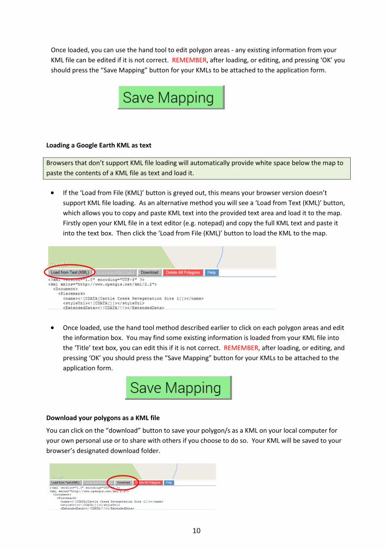
Once loaded, you can use the hand tool to edit polygon areas - any existing information from your
KML file can be edited if it is not correct. REMEMBER, after loading, or editing, and pressing ‘OK’ you
should press the “Save Mapping” button for your KMLs to be attached to the application form.
Loading a Google Earth KML as text
Browsers that don’t support KML file loading will automatically provide white space below the map to
paste the contents of a KML file as text and load it.
If the ‘Load from File (KML)’ button is greyed out, this means your browser version doesn’t
support KML file loading. As an alternative method you will see a ‘Load from Text (KML)’ button,
which allows you to copy and paste KML text into the provided text area and load it to the map.
Firstly open your KML file in a text editor (e.g. notepad) and copy the full KML text and paste it
into the text box. Then click the ‘Load from File (KML)’ button to load the KML to the map.
Once loaded, use the hand tool method described earlier to click on each polygon areas and edit
the information box. You may find some existing information is loaded from your KML file into
the ‘Title’ text box, you can edit this if it is not correct. REMEMBER, after loading, or editing, and
pressing ‘OK’ you should press the “Save Mapping” button for your KMLs to be attached to the
application form.
Download your polygons as a KML file
You can click on the “download” button to save your polygon/s as a KML on your local computer for
your own personal use or to share with others if you choose to do so. Your KML will be saved to your
browser’s designated download folder.

11
8. MORE INFORMATION
For more information or assistance using the mapping tool please contact your Service Provider on:
1800 899 486 (in the Wet Tropics)
1800 504 699 (in the Burdekin)
Or the Department on 1800 552 008.