Embed Size (px)
Citation preview
ContestedTerritory
Mapping Peru in the Sixteenth
and Seventeenth Centuries
HEIDI V. SCOTT
University of Notre Dame Press Notre Dame, Indiana
N
Scott 000.FM 7/15/09 1:07 PM Page iii
© 2009 University of Notre Dame Press
Copyright © 2009 by University of Notre DameNotre Dame, Indiana 46556
www.undpress.nd.eduAll Rights Reserved
Manufactured in the United States of America
Library of Congress Cataloging-in-Publication Data
Scott, Heidi V., 1976 ‒
Contested territory : mapping Peru in the sixteenth and seventeenth centuries / Heidi V. Scott.
p. cm. — (History, languages, and cultures of the Spanish and Portuguese worlds)
Includes bibliographical references and index.isbn-13: 978-0-268-04131-1 (pbk. : alk. paper)isbn-10: 0-268-04131-8 (pbk. : alk. paper)1. Peru—History— Conquest, 1522‒1548. 2. Peru—History—1548 ‒1820.
3. Peru—Discovery and exploration— Spanish. 4. Spaniards—Peru—History—16th century. 5. Spaniards—Peru—History—17th century.6. Cultural landscapes—Peru. 7. Human geography—Peru. I. Title.
f3442.s36 2009
985'.02— dc22
2009027704
∞ The paper in this book meets the guidelines for permanence and durability of
the Committee on Production Guidelines for Book Longevity of the Council on
Library Resources.
Scott 000.FM 7/15/09 1:07 PM Page iv
© 2009 University of Notre Dame Press
o n e
Landscape and the Spanish Conquest of Peru
In 1527, about five years before the conquest of Peru began in earnest,a small band of Spaniards, sailing southward along the Pacific coast inthe vicinity of the equator, captured an indigenous seagoing raft bearingtrade goods that included, among other things, emeralds and fine tex-tiles. Described in the Relación Samano-Xerez , a brief report of uncertainauthorship, this event gave the Europeans a first glimpse of the richesthat fueled the subsequent exploration and conquest of Peru. The ac-count, however, also provides what may well be the earliest Europeandescription of Peru’s northernmost coastal settlements, first viewedby Francisco Pizarro and a small group of followers in 1528. Althoughthis text portrays a moment of first encounter, it does not, as one mightexpect, convey a wonder-filled vision of exoticism and otherness. In-stead, it projects an image of a landscape that is startlingly European innature:
[T]here are many sheep and pigs and cats and dogs and other ani-mals and geese, and there [ in the coastal towns] the blankets ofcotton and wool that I mentioned above are made, and [also] theneedlework and the beads and objects of silver and gold, and the
1
Scott 01 6/29/09 3:08 PM Page 1
© 2009 University of Notre Dame Press
people are very rational; they appear to have many tools made ofcopper and other metals with which they work their fields, andthey mine gold and practice all kinds of farming; the streets oftheir settlements are very well laid out; they have many types offortresses and they live in a state of order and justice; the womenare white and well-dressed and almost all of them are embroider-ers; there is an island in the sea near the settlements where theyhave a temple built in the style of a rustic shelter, hung with veryfine embroidered cloth, and where they have an image of a womanwith a child in her arms and who is called María Mexía.1
This account of Peru’s human geographies may be understood as an ex-ceptionally vivid fantasy of familiarity and, by extension, of possession.Only by making the alien known and by forging connections wherenone existed, could the incommensurable be comprehended and de-scribed, and only by description could this new world be transportedto Spain and laid at the monarch’s feet.2 By insisting on the familiarityof the yet-to-be-possessed, the account conveys to its royal recipient anardent plea for his approval of the conquest of this territory: accordingto the text, this land and its inhabitants are already almost Spanish, for allthe elements of a civilized Castilian existence—including even a fore-shadowing of Christian knowledge—are identified.3
This excerpt, belonging to one of the earliest known European de-scriptions of what was to become Peru, reveals the powerful role thatcultural preconceptions, ambitions, and desires played in shaping earlySpanish interpretations and representations of the Americas. In terms ofshared language, values, and beliefs, the author of the document was, toborrow a phrase from Mignolo, situated in the self-same “locus of enun-ciation” as his European audience—a cultural positioning that shapedhis account at a profound level.4 Clearly, however, those early modernEuropeans who ventured to Peru and other parts of the New Worlddid not occupy merely linguistic and cultural spaces, exclusively sharedwith their companions and compatriots in distant Europe. Rather, theyalso traveled through real geographical spaces,5 traversed physical ter-rain, and interacted in diverse ways with indigenous peoples.
Just as the Spaniards’ perceptions and portrayals of New Worldlandscapes were influenced by their membership in shared cultural com-
2 Contested territory
Scott 01 6/29/09 3:08 PM Page 2
© 2009 University of Notre Dame Press
munities and by individual interests, so too, their perceptions wereshaped, in sometimes unpredictable ways, by the local contexts in whichthey found themselves, whether as conquistadors, travelers, or residents.In similar fashion, the construction of colonial geographical knowledgeabout the Americas depended as much on the local and ever-changingconditions in which it was produced as it did on shared cultural assump-tions. The emphasis on change is significant, for the ways in which theNew World’s colonial landscapes were perceived, the meanings thatwere attached to them, and the manner in which they were portrayedwere never constant but were subject to ongoing transformation.
$ Scholarly interest in the geographical knowledge and writingsthat took shape in the wake of Spain’s conquest of the Americas is byno means a recent phenomenon. It can be traced back to the nineteenthcentury and earlier, especially in the Spanish-speaking world.6 Recentyears, however, have witnessed a remarkable surge in the publication ofstudies on colonial Latin America that are concerned more broadly withissues of geography and space. The Columbian quincentenary broughtwith it a flurry of publications on European visions of the New Worldin the early years of encounter and exploration.7 Since then, increasingattention has been paid to the production, use, and representation ofcolonial (and especially urban) spaces in Spanish America and to theconstruction of colonial geographical knowledge.8 Within this grow-ing literature, studies that focus on Peru are not absent. Extensive workexists on Andean concepts of space, territory, and landscape, both priorto and during the colonial era,9 and on changing post-conquest pat-terns of landholding and usage.10 Likewise, a number of scholars haveexplored the conflicts and differences that emerged between indigenousand Spanish concepts of space and territory, as well as cross-culturalnegotiations over territorial control.11 Others have addressed practicesof colonial domination and resistance associated with the creation anduse of urban spaces.12 The geographical dimensions of numerous colo-nial chronicles, descriptions, and natural histories of Peru have also at-tracted growing, albeit still limited, scholarly attention.13
Colonial negotiations over Peru’s landscapes still remain to be ex-plored more fully, especially where the diversity of Spanish experiences
Landscape and the Spanish Conquest of Peru 3
Scott 01 6/29/09 3:08 PM Page 3
© 2009 University of Notre Dame Press
and portrayals of those landscapes is concerned. It is striking that stud-ies of Spanish visions of Peru, even in the early years of conquest andcolonization, are relatively few and far between compared with thosethat focus on Mexico and the Caribbean—a phenomenon that may berelated in part to the lack of wonder that, as Graubart suggests, char-acterizes many early European accounts of Peru.14 This book, however,is less concerned with dwelling on expressions of wonder in the fetish-ized moments of first encounter than it is with drawing attention tothe frequently mundane and everyday circumstances that shaped ongo-
ing negotiations over landscape and geographical knowledge in Peru,and that may be traced in documentation that goes well beyond explic-itly geographical accounts and descriptions.15
In placing landscape and geographical knowledge at the center ofthe study of early colonial Peru, this book explores some of the ways inwhich the viceroyalty’s human and physical landscapes and its Amazonfrontiers were experienced, portrayed, and negotiated—both physi-cally and discursively—over the course of the sixteenth and early sev-enteenth centuries, predominantly from within Peru itself, but also fromthe geographical location of Spain. In particular, it questions the no-tion of a unified and homogeneous “Spanish geographical imagination”that was straightforwardly opposed to Amerindian understandings andperceptions of landscape. In doing so, it demonstrates how Peru’s land-scapes and territories were imbued with meaning by Spaniards andSpanish Americans in diverse, improvisatory, and frequently conflict-ing ways, and were shaped within shifting networks of power, agency,and interest.
My predominant (but by no means exclusive) emphasis on Span-ish and Spanish American experiences and portrayals may appear to goagainst the grain of much recent scholarship that challenges the mar-ginalization of Amerindian, mestizo, and other groups in colonial society.As Elliott observes, however,
our contemporary discovery of the presumed “otherness” ofothers has embraced the non-European world to the exclusion ofthe conquerors, colonists, and chroniclers of the sixteenth cen-tury; the observers have been accorded a privileged status that hasbeen denied their observers, whose individual voices, reduced to
4 Contested territory
Scott 01 6/29/09 3:08 PM Page 4
© 2009 University of Notre Dame Press
an unattractive unison, are dismissed as “the hegemonic voices ofthe West.” But in reality there are many voices, among the con-querors and conquered alike.16
In citing Elliott’s comments, my intentions are emphatically not tosuggest that “the colonizers” should be returned to a privileged locationin historical analysis. On the contrary, this study is propelled by a con-viction that the adoption of nuanced approaches to the Spaniards’ expe-riences of landscape and their imaginative geographies can contributeto dismantling narratives that aggrandize the coherence and power ofEuropean imperialism and perpetuate its binaries. Rather than focus ex-clusively on dramatic conflicts between Spanish and indigenous groups,this book explores how knowledge of landscape and geography was ne-
gotiated within colonial networks that frequently confounded clear-cutoppositions between colonizers and colonized.
Within these networks, as I hope to show, Amerindian groups didnot merely resist the imposition of alien geographical notions but playedan active role in shaping Peru’s colonial geographies, as well as Spanishexperiences and perceptions of its landscapes. As historians have re-peatedly recognized, Spanish colonialism in the New World was heavilydependent on the presence of colonial subjects, in practical as well asideological terms.17 Taking account of how Spanish engagements withPeruvian landscapes were molded by native agency is therefore crucial:as the viceroyalty took shape, the beliefs of indigenous people, theirsettlement patterns and mobility, and their sheer physical presence andabsence were all reflected in the diverse ways in which Peru’s landscapesmattered for Hispanic populations.
Landscape, Territory, and Colonialism
As Sluyter observes, no significant attempts have yet been made to con-struct a “comprehensive geographic theory of colonialism and land-scape,”18 despite the dramatic and far-reaching transformations thatlandscapes have so often undergone as a result of European overseas ex-pansion and colonization. Central to his proposals for developing such atheory is the contention that reciprocal interactions between indigenous
Landscape and the Spanish Conquest of Peru 5
Scott 01 6/29/09 3:08 PM Page 5
© 2009 University of Notre Dame Press
populations, Europeans, and material landscape resulted in that land-scape’s transformation. In outlining his approach, Sluyter decisively re-jects the notion that European colonizers were the “ultimate determi-nant” in the process of transformation19—a deeply rooted belief thatfinds expression in Elliott’s suggestion that “America had given Europespace, in the widest sense of that word— space to dominate, space inwhich to experiment, and space to transform according to its wishes.”20
Although the central purpose of my study is not to contribute to thedevelopment of Sluyter’s theory, significant common ground exists be-tween his objectives and my own. In exploring colonial negotiations overPeru’s landscapes, I seek to convey, like Sluyter, that they were never theproduct of European agency alone, but emerged from ongoing inter-
actions between the material landscape, its indigenous inhabitants, andHispanic populations.
Before I turn my attention to these negotiations, however, it seemsappropriate to explain how I use and understand the term “landscape”in this study of colonial Peru, not least because the historical origins ofthe term are European. If the term is understood in a narrowly gene-alogical fashion, centered on particular, elite “ways of seeing”21 that firstemerged in Renaissance Italy with the discovery of perspective, then itsuse, as Bender suggests, is distinctly limited outside very specific cul-tural and geographical contexts. Instead of restricting the term to a re-duced set of historical, cultural, and geographical associations, I use it,like Bender, in a manner that is intentionally expansive and that hasroom for diverse ways of experiencing, relating, and giving meaning toplaces and environments:
If . . . we broaden the idea of landscape and understand it to bethe way in which people — all people — understand and engagewith the material world around them, and if we recognize thatpeople’s being-in-the-world is always historically and spatiallycontingent, it becomes clear that landscapes are always in pro-cess, potentially conflicted, untidy and uneasy.22
By speaking of “landscape” in the context of sixteenth- and seventeenth-century Peru, then, my intention is not to impose on its inhabitants (Eu-
6 Contested territory
Scott 01 6/29/09 3:08 PM Page 6
© 2009 University of Notre Dame Press
ropean or otherwise) a set of alien concepts that they did not possess,but instead to gain insight into an array of experiences, meanings, andembodied relationships that were constantly being reshaped. Indeed, thevery value of the term “landscape” may be seen to lie in what one cul-tural geographer has described as landscape’s “duplicity”—its perennialrefusal to be pinned to any fixed or unitary meaning.23
My explorations of landscape and colonialism in Peru are informedby ongoing endeavors in cultural geography and anthropology to con-ceptualize landscape as animated rather than static, as process ratherthan as product, and as embodied experience rather than as disembod-ied vision.24 As Rose suggests, landscape does not possess inherent orpredetermined qualities, but instead is made to “matter”— to take ondiverse meanings and to have effects on people’s lives by means of “theeveryday practices and activities that surround it.”25 By conceptualizingPeru’s colonial landscapes in these ways, emphasis may be shifted awayfrom the analysis of selected representations and toward an explorationof the varied spatial, material, and discursive practices that continuouslyshaped those landscapes and the meanings with which they were im-bued. At the same time, the dynamism of landscape may be brought tothe fore by treating colonial texts not simply as sources of “finished”landscape representations that are open to critical analysis, but as resources
that allow valuable insights into ongoing colonial negotiations.Peru’s colonial landscapes were not merely represented in text and
image, but were also experienced in corporeal and spatial ways by allthose who traveled through, inhabited, and sought to control them.These aspects have not been ignored in work on colonial Latin America:recent studies that highlight the impact of frequently harsh New Worldenvironments on explorers’ and conquistadors’ bodies— and, indeed,on their very ambitions and objectives— provide a clear example ofthis.26 Frequently, however, the profound physicality of the Spaniards’experiences has been sidelined by concerns for the cultural (and hencemetaphorical) locations from which they perceived and wrote about theAmericas, as well as by a tendency to focus on their role as agents whoappropriated and transformed America’s spaces, while paying scant at-tention to how they were affected by those spaces.27 “Negotiations overlandscape,” therefore, certainly refers to verbal and textual exchanges
Landscape and the Spanish Conquest of Peru 7
Scott 01 6/29/09 3:08 PM Page 7
© 2009 University of Notre Dame Press
but also, and no less significantly, to the ways in which landscape wasexperienced, struggled over, shaped, and used in physical and corpo-real ways.
I have also chosen to speak of “negotiation” because it calls forthconditions of contingency, compromise, and modification. Althoughthis choice of terminology may appear to trivialize or sideline the vi-olence and conflict that was ever-present in the colonial world of Peru,this is not my intention: as Bolaños writes, the study of colonialism inLatin America brings with it a responsibility to remember that it wasfounded on cultures of violence and exploitation.28 Instead, my use ofthis term is intended to reflect the ways in which landscape experiences,perceptions, and portrayals were contextualized and subject to change,instead of being rigidly predetermined by cultural origins or the exis-tence of an unbridgeable colonial divide.
This study, although focusing in part on the ways in which colonialnegotiations over landscape unfolded within particular localities or re-gions, is equally concerned with tracing their development at the vicere-gal and transatlantic level. Locally focused negotiations over landscapeand those that extended beyond the local sphere were inextricably con-nected: the discursive and embodied practices that surrounded particu-lar landscapes were never restricted to the local, but always formed partof broader networks of practice and communication that connectedthem with other, more distant, landscapes and spaces.29
The following chapters attempt to convey how Peruvian landscapesand territories were negotiated not just within Peru itself but also fromacross the Atlantic in Spain. As this study illustrates, particularly in chap-ters 5 and 6, these negotiations not only focused on clearly demarcatedlocalities or regions but also unfolded around vast and often vaguely de-fined geographical spaces that extended across and beyond the vice-royalty. By speaking of both “landscape” and “territory,” I seek to con-vey a clear sense of this multiscalar perspective. In using these two terms,I also distinguish between negotiations that revolved, on the one hand,around particular places and regions that were experienced directly bythe Spanish, and, on the other, around the representation of frequentlyextensive geographical spaces that largely lay beyond the realm of thecolonizers’ experience.
8 Contested territory
Scott 01 6/29/09 3:08 PM Page 8
© 2009 University of Notre Dame Press
Cartography, Text, and Landscape
Material and discursive struggles over landscape, territory, and spacehave always been central to the implementation of colonial and imperialventures. The production of diverse maps and cartographies in and ofSpanish America, as in other parts of the world, played a highly signifi-ant role in the process of conquest and colonization. Besides facilitat-ing America’s emergence within an increasingly dominant Western geo-graphical worldview, mapmaking reflected and reinforced the materialtransformation of New World landscapes and the creation of new, co-lonial spaces.30 The intense scholarly interest that has emerged aroundcolonial Spanish mapping practices represents a welcome move awayfrom the once widely held view that imperial Spain contributed little tothe development of modern European cartography or geography.31
It may be argued, however, that Spain’s nascent modern cartographyhas come to represent an “overdetermined signifier”32 of Spanish impe-rialism in the New World. Despite the undeniable role that cartographyplayed in the service of imperialism, it was by no means representative ofall Spanish geographical ideas. Indeed, it appears to have been of limitedrelevance for a majority of the Spaniards and Spanish Americans whoexperienced, inhabited, and portrayed the New World and its landscapesin the sixteenth and seventeenth centuries.33 As such, it is important, assome scholars have done, to take account of other, “popular” forms ofmapmaking and visual representation that were practiced alongside for-mal cartography in early modern Spain as well as in the Americas.34
The significance of cartography and mapmaking should not beallowed to overshadow the value of written text as a source of insightsinto colonial negotiations over landscape and geographical knowledge inthe New World. As a result of their great scarcity for many areas of earlycolonial Spanish America, including the Viceroyalty of Peru, extant co-lonial maps must frequently be considered a supplementary rather thana principal historical source.35 Overwhelmingly, Peru’s landscapes wereportrayed and contested through the production of written texts ratherthan of maps, and it is in written records that the most detailed accountsof everyday, nonrepresentational negotiations over those landscapesmay be found. The scarcity of cartographic records for early Spanish
Landscape and the Spanish Conquest of Peru 9
Scott 01 6/29/09 3:08 PM Page 9
© 2009 University of Notre Dame Press
Peru may therefore be regarded not as a disadvantage but as an invita-tion to explore negotiations over its landscapes and territories in a di-verse range of administrative, ecclesiastical, and other documents thatfill the colonial archives.
In drawing on these written records, the chapters that follow do notattempt to focus on a comprehensive spectrum of colonial identities.Most notably, perhaps, they do not address the ways in which Peru’slandscapes were experienced and perceived by women, for all the textsthat I draw on, without exception, were written by men. Neither “colo-nizing women” nor those women who experienced colonialism everconstituted unitary groups:36 as recent scholarship shows, however, theirspatial practices, perceptions of landscape, and geographical imagin-ings often differed significantly from those of their male counterparts.37
Given my concern for bringing to light difference and diversity among“the colonizers,” such an omission may strike some readers as puzzling,even inexcusable.
In focusing primarily on the writings of those whose voices areheard more insistently in the colonial archive, however, I believe thatthese complex entanglements can be most effectively explored. Theabundant writings produced by administrators, conquistadors, and ec-clesiastics not only shed light on their own engagements with landscape,perceptions, and experiences, but also provide a window onto an arrayof other practices—indigenous as well as Hispanic—that were centralto negotiations over landscape. Indigenous-authored sources are notignored by this study, for they too shed valuable light on how nativeagency played a key role in shaping Spanish engagements with land-scape. Accounts of merits and services, geographical descriptions, andother documents produced by Andean subjects reveal, moreover, thatindigenous experiences and portrayals of landscape were no less diverse,improvisatory, or open to change than those of Spaniards or SpanishAmericans.
Spatial, Temporal, and Thematic Limits
This study cannot claim, of course, to include every area of the Viceroy-alty of Peru or to chart the continuous unfolding of colonial negotiations
10 Contested territory
Scott 01 6/29/09 3:08 PM Page 10
© 2009 University of Notre Dame Press
over landscape throughout a period of more than one hundred years.Inevitably, the study is geographically selective; although commencingon the northern fringes of the Inca empire, it is predominantly orientedtoward the central highlands of the Audiencia of Lima and the tropi-cal frontiers of the Audiencia of Charcas (see figs. 1 and 2). The existenceof rich textual records that relate to the colonial provinces of Huaro-chirí, Jauja, and Huamanga has placed these areas in a particularly promi-nent position. Materials relating to these provinces have already beenextensively studied by Andeanist historians. Rather than seek out newor little-known sources, however, I am more concerned with revisitingthose that are familiar and exploring the ways in which they can providefresh insights into colonial negotiations over landscape and geographi-cal knowledge.
Chapters 5 and 6 also focus on the Amazon frontier regions ofpresent-day Bolivia and southern Peru: above all, the inclusion of theseareas is intended to further scholarly efforts to challenge the frequentlyencountered segregation of the Andes and Amazon in historical stud-ies.38 Although the Spanish conquest undoubtedly brought about thewidespread disruption of cultural and political linkages and networks ofexchange between Andes and Amazon—thereby continuing a processthat had already been set in motion by the Incas— these linkages didnot disappear altogether. Large-scale military expeditions of conquestinto the Amazon had largely ceased by the beginning of the seventeenthcentury, yet Spanish interest in the region did not disappear; indeed,sporadic exchanges and encounters between the highlands and tropicallowlands continued throughout the colonial period.39 If the Amazon re-gions are persistently portrayed in colonial texts as spaces that were de-tached from and in many ways the antithesis of the Andean highlands(whether in a positive or negative sense), many writings also confoundthis stark dualism. As this book endeavors to illustrate, fascinating tex-tual sources exist that allow the negotiations that took place over Peru’sAmazon frontiers in the sixteenth and seventeenth centuries to be ex-plored in considerable depth.
Focusing on petitions and accounts produced by Peru’s first con-quistadors, chapter 2 traces changes in the Spaniards’ experiences andperceptions of landscape as they passed from the exploration of the Pa-cific coastline to the conquest of the Inca empire. By comparing these
Landscape and the Spanish Conquest of Peru 11
Scott 01 6/29/09 3:08 PM Page 11
© 2009 University of Notre Dame Press
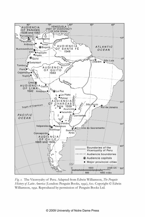
Fig. 1. The Viceroyalty of Peru. Adapted from Edwin Williamson, The PenguinHistory of Latin America (London: Penguin Books, 1992), 610. Copyright © EdwinWilliamson, 1992. Reproduced by permission of Penguin Books Ltd.
Scott 01 6/29/09 3:08 PM Page 12
© 2009 University of Notre Dame Press
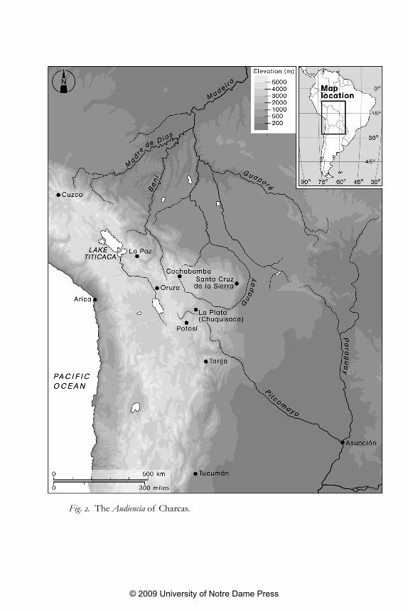
Fig. 2. The Audiencia of Charcas.
Scott 01 6/29/09 3:08 PM Page 13
© 2009 University of Notre Dame Press
texts with native testimonies of conquest produced in Jauja, I arguethat the conquistadors’ physical engagements with landscape, and con-sequently their portrayals of it, were strongly shaped by the agency ofindigenous groups and by their physical presence or absence. A finalsection examines how, in the wake of conquest, Peru’s indigenous popu-lations continued to play a crucial role in shaping the material landscapesof the new viceroyalty and the ways in which Europeans experiencedand portrayed them.
Chapter 3 shifts the discussion from the era of conquest to the 1580s.By examining the production of geographical accounts in response tothe questionnaires prepared by the Council of the Indies, it questionsthe notion that indigenous and Spanish geographical representationswere always straightforwardly opposed or defined by clear-cut relationsof domination and resistance. As well as questioning the suitability of“resistance” as a concept for understanding indigenous participationin this process, this chapter illustrates the point that Spanish portrayalsof landscape produced in Peru were far from homogeneous and wereoften at odds with the “official” geographical notions embedded withinthe questionnaire.
Whereas chapter 3 focuses predominantly on the colonial provincesof Jauja and Huamanga, chapter 4 traces Spanish negotiations over thelandscapes of Huarochirí between the 1570s and the 1630s. Beginningwith a dispute over jurisdictions that took place between two parishpriests, it goes on to explore the ways in which the landscapes of theprovince were experienced and represented by Jesuit missionaries, acrown official, and seventeenth-century extirpators of idolatry. In doingso, it draws attention to the significance of travel in shaping these di-verse individuals’ experiences of Huarochirí, but also foregrounds howtheir portrayals of travel in the province were influenced by the natureand extent of their involvement in local affairs, as well as by their per-sonal and professional objectives.
In chapter 5, the focus shifts from descriptions of Huarochirí pro-duced in Peru to portrayals of the viceroyalty’s Amazon frontiers pro-duced in early-seventeenth-century Madrid by a Spanish officer, a maestre
de campo named Juan Recio de León. By tracing the ways in which hisportrayals of Amazonia and of his proposed colonizing venture were
14 Contested territory
Scott 01 6/29/09 3:08 PM Page 14
© 2009 University of Notre Dame Press
continually revised, I demonstrate that Recio, far from merely succumb-ing to “contagious” tales about Paititi, El Dorado, and other mythicallocations, opportunistically tailored his reports and petitions to suit theever-changing context of prominent royal interests and concerns. In ad-dition, then, to questioning the homogeneity of colonial Spanish por-trayals of Amazonia, this chapter examines how the material and socialspaces of the royal court played a crucial role in influencing the waysin which Recio chose to represent the tropical lowlands to the east ofthe Andes.
The subtropical frontier regions of Charcas that connected theAndean highlands to Amazonia are central to chapter 6. Here, I aim tocall into question the notion that clear-cut divisions between Andes andAmazon were common to all Spanish and Spanish-American geographi-cal portrayals in the early colonial era. By examining texts produced byconquistadors, missionaries, and royal officials between approximately1550 and 1650, I show that stark binary divisions were frequently moder-ated by the perceived existence and functions of an “in-between space”that connected or separated the Andes and Amazon. Once again, thischapter conveys how colonial negotiations over landscape unfoldedthrough the unpredictable interactions of discursive and embodied prac-tices that were performed at local, regional, viceregal, and transatlanticscales. In a brief concluding section I draw together the themes outlinedabove and reflect on the insights that they collectively provide on the en-tanglements between landscape and colonialism in early Spanish Peru.
Landscape and the Spanish Conquest of Peru 15
Scott 01 6/29/09 3:08 PM Page 15
© 2009 University of Notre Dame Press