Embed Size (px)
Citation preview
State of Australian Cities National Conference 2011
Stream: Social
MAPPING NEIGHBOURHOOD FIELDS OF CARE
Ian Woodcock, Simon Wollan, Kim DoveyThe University of Melbourne, Victoria, Australia
INTRODUCTION
It is almost a truism that place-identity embodies different meanings for different people,highlighted during conflicts over shared space by different groups. But to what extent do theterms of such place-identity relate to the requirements of a development approvals systempremised on place-sensitive planning? And to what degree, and in what ways are suchmeanings shared or differentiated within a group of residents who are united in its defence?These questions are explored through a case study of the inner-city Melbourne suburb ofBrunswick. The paper utilizes interview data to construct and map ‘fields of care’: the spatialfield of concern for each interviewee. Using this technique, it was found that intervieweesexperience the place as a product of how they move around it, particularly via walking, cyclingand public transport. There are significant variations in perceived place boundaries, centres ofmeaning and ‘hot spots’ with intense intersections of different meanings in the same places.The ‘field of care’ maps illustrate the ways people talk about place and provide a method forurban research that is sensitive not only to place-identity, but highlights what is oftenoccluded in qualitative research on place: the differences in place-identity that exist withingroups otherwise regarded as having a similar relationship with a place. These maps are thencontrasted with others that effectively represent the field of care of the planning system –maps of development projects, the areas notified by planning officials and the source ofobjections. The nexus between these two kinds of map is the requirement placed onobjectors to state how a proposed development will affect them. We suggest that thesedifferences are illustrative of the problem presented to planning policy by the issue of place-identity, enshrined in legislation as ‘neighbourhood character’.
Fields of Care
The phrase ‘field of care’ is primarily associated with the humanistic geographer Yi-Fu Tuanto refer to what he calls the ‘affective bond between people and place or setting’ (Tuan1974:4). Tuan argued that through place experience, that is, the daily activity of living in andmoving through specific environments, we come to form attachments to places. In distinctionto the more public symbolisation of places connected with national history or state power,fields of care may not be so easily apprehended by visitors, being the places where peoplecreate interpersonal ties and develop social capital, both of which require extended time aswell as material settings (Tuan 1999). Key for Tuan was the distinction such experiencemakes between place and space – the former rooted and particular, the latter mobile, openand generic. This duality has a long and contested history within theoretical discussion onplace, where progressive ideas of openness and mobility have been seen to threaten such asense of place or to be required to replace it (Massey 1994). Many have been concerned toeschew the concept of place altogether because of its imputed regressiveness – closed,static and nostalgic. Similar charges are frequently and stereotypically made of people whoobject to intensification projects in Australian cities, the so-called NIMBY or ‘not-in-my-backyard’ conservative with a nostalgic and reactionary sense of place-identity. And yet, theplanning schemes that govern the approval of urban intensification are fundamentally drivenby ideas about place, identity and community – that new development should respect andenhance neighbourhood character – these are seen as goods that new development shouldaspire to achieve. Performance-based planning within the Victorian planning systemdemands that development proposals be assessed against such criteria rather than becontained by quantifiable prescriptions for height, density or built form. The planning anddevelopment assessment process includes requirements to consult communities, to createneighbourhood character policy, to undertake site analyses and character statements and tonotify affected property owners and occupants. It contains several iterations of processes
designed to establish fields of care among residents, planners, developers and designers,albeit to differing degrees of depth and rigour. Thus, when making structure plans andneighbourhood character policy, planners will consult with communities about the aspects ofthe suburbs they live in that they care about and seek guidance on a qualitative vision of thefuture. With the over-arching view that planning authorities necessarily have, this processassumes that individual fields of care can be aggregated and combined into a coherentvision, or at least that some compromise can be achieved about differing versions of suchsenses of place (Wood et al 2006). While such juggling and calibration is at the heart ofplanning, our interest here is to shed some light on the spatiality of this qualitative domain interms of residents’ experience of place and how it plays out within the developmentassessment process.
Interviews, archives and maps
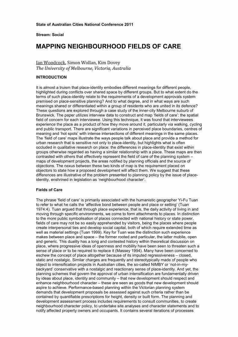
Brunswick in Melbourne’s inner northwestern suburbs has a long-standing history of residentactivism and has been euphemistically known as the ‘people’s republic of Brunswick’(Woodcock et al 2009). Local resident groups have connections to the metropolitan-wideassociation known as Save Our Suburbs (SOS) and activism has included resistance tointensification and high-rise development. As planning policy and development assessmentprocedures are predominantly focused on responding to objections (rather than pollingrepresentative samples of residents) our focus was on local residents who have taken a keeninterest in planning and development in Brunswick. A combination of fieldwork and the localgovernment (City of Moreland) database was used to analyse all development applicationsbetween the years 2002-2007 and their passage through the approvals system (Woodcock etal 2011). From this archive, potential interviewees were identified from the register of casesthat were heard at the state planning tribunal, VCAT. Fourteen interviewees were selectedthis way and a further three self-presented through their work on planning committees whohad been notified about the project. Alongside this selection process, the location of thesecontentious development projects, the area notified in each case and the sources ofobjections were mapped. A composite ‘spider’ map of these projects and objectors is shownin Figure 1.
Figure 1. ‘Spider map’ of development application sites (red), notification areas
(orange) and sources of objections (black/green dots) in Brunswick, for the period2002-7
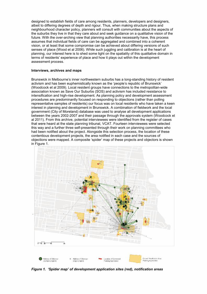
Semi-structured in-depth interviews were conducted with the 17 participants, taking anaverage of 90 minutes each. Interviewees were roughly equal in terms of gender, agedbetween late 20s and late 70s and varied in their socio-economic background and ethnicity.The format of the interviews followed a set of three major themes. Firstly, to elicit anunderstanding of how each interviewee carried out their daily life, how they used places inBrunswick and how they moved around. Secondly, we asked questions about their sense ofBrunswick as a place: where did it begin and end, were any parts more distinctive thanothers, where was the centre, and why. And thirdly, we were interested in their experiencesas an objector and the reasons they became involved in a residents’ campaign. A primaryinterest here was how Brunswick, designated a Major Activity Centre under state planningpolicy, actually functioned for residents and what it meant as such. All interviews weretranscribed in full. After a series of experiments with representational techniques andsymbology, each interview transcript was interpreted as a map (Figure 2) based on thecontent of the first and second parts of the interview. While initially we were interested in anumber of different ways of mapping this content, for example, places with positive andnegative associations/values attached to them, or actual and virtual places (currently existingversus potential proposals) we decided against this kind of differentiation for a number ofreasons. Many statements made by interviewees were ambiguous. Some places raised inconversation would have a host of associations and uses attached to them, and it wasunclear whether they had a neutral, negative or positive value – sometimes they might haveall three, sometimes it was very hard to say. While such slippery meanings are of interest, forour present purposes we are not concerned with making maps of relative value as such.
Furthermore, the attributes of a site as it exists or as it could be, while interesting in othercontexts, are of a different order than the fact that the interviewee mentioned the site. Thus,what the maps of the interviews illustrate is the range of places of any kind or valuementioned by the interviewee. As such, this allows a comparison between the interview mapsand the ‘spider’ map of projects and objectors. While the reasons residents may give forobjecting to development proposals vary, we have not differentiated between them on thisbasis, we have located them on the map to illustrate spatial relationships. It is this emphasison spatiality over meaning that allows us to compare maps produced by very different means,and to draw out issues in relation to the concept of fields of care.
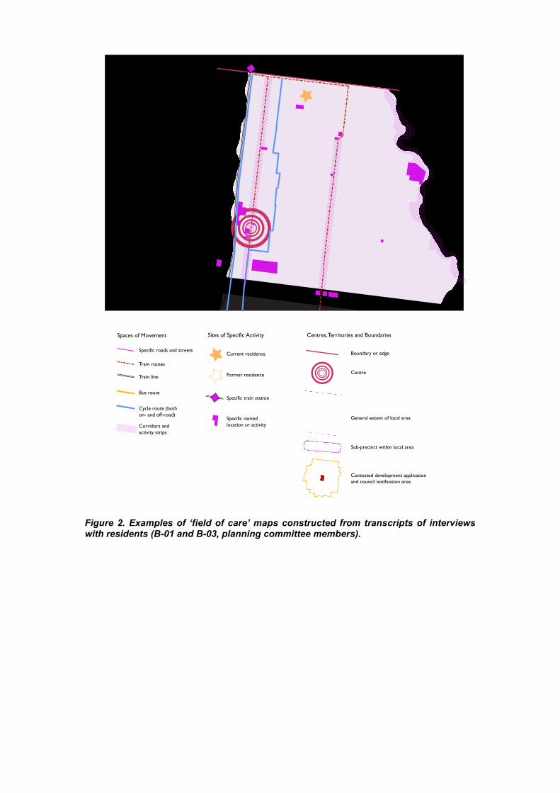
Figure 2. Examples of ‘field of care’ maps constructed from transcripts of interviewswith residents (B-01 and B-03, planning committee members).
Specific roads and streets
Tram routes
Train line
Bus route
Cycle route (bothon- and off-road)
Corridors andactivity strips
Current residence Boundary or edge
Centre
Sub-precinct within local area
Contested development applicationand council notification area
General extent of local area
Former residence
Specific train station
Specific namedlocation or activity
Spaces of Movement Sites of Specific Activity Centres,Territories and Boundaries
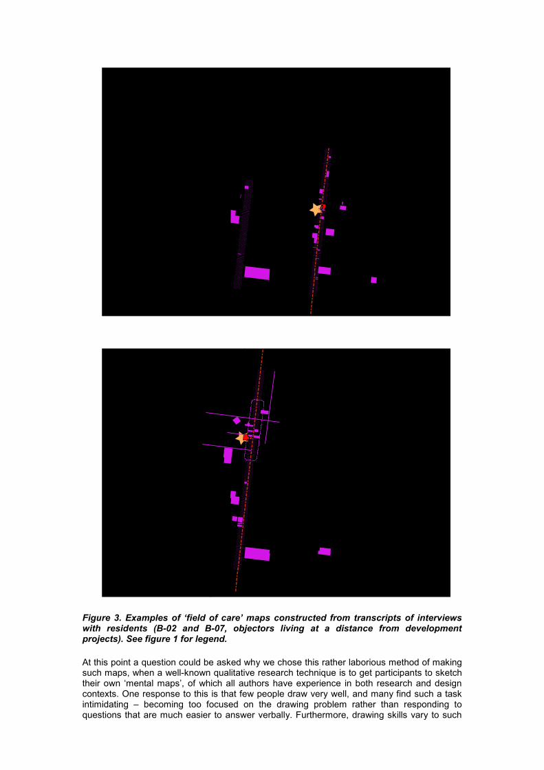
Figure 3. Examples of ‘field of care’ maps constructed from transcripts of interviewswith residents (B-02 and B-07, objectors living at a distance from developmentprojects). See figure 1 for legend.
At this point a question could be asked why we chose this rather laborious method of makingsuch maps, when a well-known qualitative research technique is to get participants to sketchtheir own ‘mental maps’, of which all authors have experience in both research and designcontexts. One response to this is that few people draw very well, and many find such a taskintimidating – becoming too focused on the drawing problem rather than responding toquestions that are much easier to answer verbally. Furthermore, drawing skills vary to such
an extent that comparisons between the maps would be likely to have more to do withpersonal representational styles than the spatial content – requiring the researcher to re-drawthe maps to achieve consistency. Another approach could have been to provide participantswith a base map and ask them to annotate it. The drawback with this is that apart fromdifferences in abilities to read maps, the graphic language of the base map could draw theattention of the participant to places they wouldn’t have otherwise considered relevant to theinterview. Lastly, however, one of the matters of interest in this process is the larger issue ofthe potential for mapping interviews and other word-based texts to spatialise their content andmake visible aspects that would otherwise remain invisible.
FINDINGS
Broadly speaking, our interviewees fell into three categories: three were members of aplanning committee looking at the development of Brunswick as a whole; 14 were objectors,of whom most (12) lived sufficiently far from the development site to not be directly affected interms of overshadowing or overlooking; and two lived immediately adjacent to thedevelopments they objected to. The relevance of these categories will be returned to later inthe discussion. We will now describe the content of the maps, firstly with a quantitativeanalysis of the entities they represent, and secondly with an interpretation of the visual impactof the maps. An important aspect of mapping is that spatial relationships are foregroundedand revealed in contrast to the semantic content normally extracted from interview texts. Assuch, images can ‘say’ things that are otherwise very difficult, if not impossible to articulateverbally because the former are spatial, multidimensional and immediate (like muchembodied experience) whereas the latter is linear and semantically associative rather thanspatial.
A simple content analysis of all 17 maps identifies a total of 61 separate entities, assummarised in Table 1. The difference between a simple count of the times these entitiesappear in the interview transcripts and on the maps derived from them is that the spatialaspect of the entities becomes clear when they are represented as a map. These entitiescover major commercial strips, the local shopping centre, landscape elements such as theMerri Creek, various parks of great difference in size, minor streets, development sites, publictransport routes/modes, and a range of other individual sites, large and small, public andprivate. The maps vary a great deal in the spatial extent and composition of entities within ofeach individual field of care. The range of entities present in any one map is between 8 and25 (or between 13% and 41%), with only 10 (16%) entities appearing on more than half of themaps. In addition to this diversity of entities within interviewees’ fields of care, it is notable thata large proportion of these are spaces of movement. Of the 10 most commonly presententities, six concern Brunswick’s main north-south spine (the Sydney Rd-Upfield RailwayCorridor), three concern Lygon St, Brunswick’s secondary spine and the last of these entitiesis the category of ‘walking in east-west streets’, generally between these two strips. Of thesemost common entities, seven are very ordinary places of movement: streets, transport linesand bike paths (See Table). Another way of seeing this is that over a quarter of the entitieswithin these fields of care are referred to by their individual names and either concernmovement in one way or another, or, in the case of Sydney Rd. and Lygon St., are alsoeveryday places of exchange.
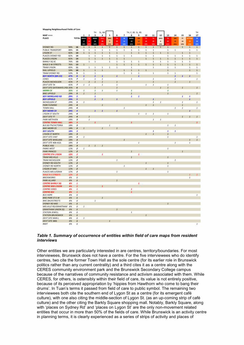
Table 1. Summary of occurrence of entities within field of care maps from residentinterviews
Other entities we are particularly interested in are centres, territory/boundaries. For mostinterviewees, Brunswick does not have a centre. For the five interviewees who do identifycentres, two cite the former Town Hall as the sole centre (for its earlier role in Brunswickpolitics rather than any current centrality) and a third cites it as a centre along with theCERES community environment park and the Brunswick Secondary College campusbecause of the narratives of community resistance and activism associated with them. WhileCERES, for others, is ostensibly within their field of care, its value is not entirely positive,because of its perceived appropriation by ‘hippies from Hawthorn who come to bang theirdrums’. In Tuan’s terms it passed from field of care to public symbol. The remaining twointerviewees both cite the southern end of Lygon St as a centre (for its emergent caféculture), with one also citing the middle-section of Lygon St. (as an up-coming strip of caféculture) and the other citing the Barkly Square shopping mall. Notably, Barkly Square, alongwith ‘places on Sydney Rd’ and ‘places on Lygon St’ are the only non-movement relatedentities that occur in more than 50% of the fields of care. While Brunswick is an activity centrein planning terms, it is clearly experienced as a series of strips of activity and places of
Mapping Neighbourhood Fields of CareTH SL, ML TH, C, BSCSL, BS TH
MAP >>>> 1 2 3 4 5 6 7 8 9 10 11 12 13 14 15 16 17PLACE TOTAL BMAC TA BMAC TA+L 380L TA W BMAC GM TA TA 20FA TA GM TT WTTGM W
17 12 21 20 9 20 11 19 13 14 20 8 25 15 14 19 20
28% 20% 34% 33% 15% 33% 18% 31% 21% 23% 33% 13% 41% 25% 23% 31% 33%
SYDNEY RD 94% 16 1 1 1 1 1 1 1 1 1 1 1 1 1 1 1 1PUBLIC TRANSPORT 88% 15 1 1 1 1 1 1 1 1 1 1 1 1 1 1 1LYGON ST 82% 14 1 1 1 1 1 1 1 1 1 1 1 1 1 1PLACES SYDNEY RD 82% 14 1 1 1 1 1 1 1 1 1 1 1 1 1 1PLACES LYGON 82% 14 1 1 1 1 1 1 1 1 1 1 1 1 1 1BARKLY SQ SC 76% 13 1 1 1 1 1 1 1 1 1 1 1 1 1WALK E-W STREETS 76% 13 1 1 1 1 1 1 1 1 1 1 1 1 1TRAM LYGON 65% 11 1 1 1 1 1 1 1 1 1 1 1RAIL UPFIELD 59% 10 1 1 1 1 1 1 1 1 1 1TRAM SYDNEY RD 53% 9 1 1 1 1 1 1 1 1 1BDY NORTH (BR-CO) 47% 8 1 1 1 1 1 1 1 1CERES 41% 7 1 1 1 1 1 1 1PLACES NICHOLSON 41% 7 1 1 1 1 1 1 1DEVT SITE TA 41% 7 1 1 1 1 1 1 1DEVT SITE GATEWAYS LYGON ST35% 6 1 1 1 1 1 1MERRI CK 35% 6 1 1 1 1 1 1BIKE UPFIELD 29% 5 1 1 1 1 1BDY MORELAND RD 29% 5 1 1 1 1 1BDY UPFIELD 29% 5 1 1 1 1 1NICHOLSON ST 29% 5 1 1 1 1 1PARK FLEMING 24% 4 1 1 1 1TOWN HALL 24% 4 1 1 1 1BDY MERRI CK 24% 4 1 1 1 1LYGON ST SOUTH 24% 4 1 1 1 1DEVT SITE TT 24% 4 1 1 1 1PARK METHVEN 18% 3 1 1 1CENTRE TOWN HALL 18% 3 1 1 1BUS BLYTH/VICTORIA 18% 3 1 1 1BIKE MERRI CK 18% 3 1 1 1BDY SOUTH 18% 3 1 1 1LYGON ST NORTH 18% 3 1 1 1DEVT SITE CHEF 18% 3 1 1 1DEVT SITE WHELANS 18% 3 1 1 1DEVT SITE 408-432L 18% 3 1 1 1PUBLIC HSG 18% 3 1 1 1PARKS WEST 12% 2 1 1PARK PRINCES 12% 2 1 1CENTRE STH LYGON 12% 2 1 1TRAMMELVILLE 12% 2 1 1TRAM NICHOLSON 12% 2 1 1SYDNEY RD SOUTH 12% 2 1 1SYDNEY RD NORTH 12% 2 1 1LYGON ST MID 12% 2 1 1PLACES MELV/GRAN 12% 2 1 1WALK N-S STREETS 12% 2 1 1BRICKWORKS 6% 1 1PARK ALLARD 6% 1 1CENTRE BARKLY SQ 6% 1 1CENTRE MID LYGON 6% 1 1CENTRE CERES 6% 1 1CENTRE BSC 6% 1 1BUS HOPE 6% 1 1BIKE PARK ST E-W 6% 1 1BIKE BACKSTREETS 6% 1 1SYDNEY RD MID 6% 1 1MELVILLE RD/GRANTHAM 6% 1 1GRANTHAM UNION SQ 6% 1 1STATION JEWELL 6% 1 1STATION BRUNSWICK 6% 1 1DEVT SITE MAN L 6% 1 1DEVT SITE 380L 6% 1 1RMIT 6% 1 1
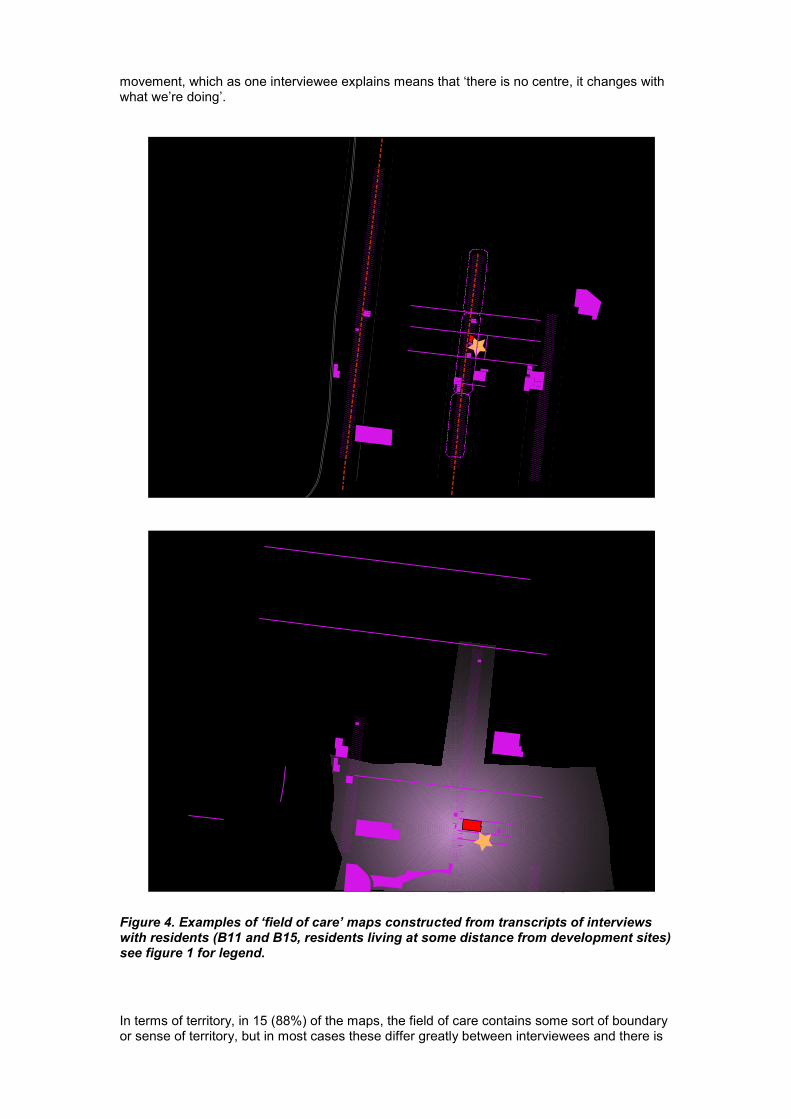
movement, which as one interviewee explains means that ‘there is no centre, it changes withwhat we’re doing’.
Figure 4. Examples of ‘field of care’ maps constructed from transcripts of interviewswith residents (B11 and B15, residents living at some distance from development sites)see figure 1 for legend.
In terms of territory, in 15 (88%) of the maps, the field of care contains some sort of boundaryor sense of territory, but in most cases these differ greatly between interviewees and there is
an ambivalence or vagueness about where Brunswick begins and ends. For example, themost frequently cited boundary / territorial distinction is that between Brunswick and Coburg(8 maps, 47%), followed by citing Moreland Road (5 maps, 29%), which is the place nameand postcode boundary. In urban morphology terms, the built form changes quite graduallythroughout the area as one moves north, but a number of interviewees associated thisboundary with claimed social differences between the two suburbs. Some said that theynever went north into Coburg so it was largely unknown territory. It is interesting that thesocial boundary of Moreland Road was cited as frequently as the north-south Upfield railwayline, which is a physical impediment to east-west pedestrian movement with significantdifferences in land use either side, while the even more substantive boundary formed by theMerri Creek was only cited in 4 interviews as a boundary. The least cited boundary was to thesouth, only being present on 3 (18%) maps, and yet there is a swathe of linear park alongalmost the entire southern edge of Brunswick where it borders the inner-city suburbs ofFitzroy North, Carlton North and Parkville. Many interviewees would move across thissouthern boundary on foot, bicycle, tram or train when travelling to and from the city – theother major domain of the broader activity spaces of most interviewees.
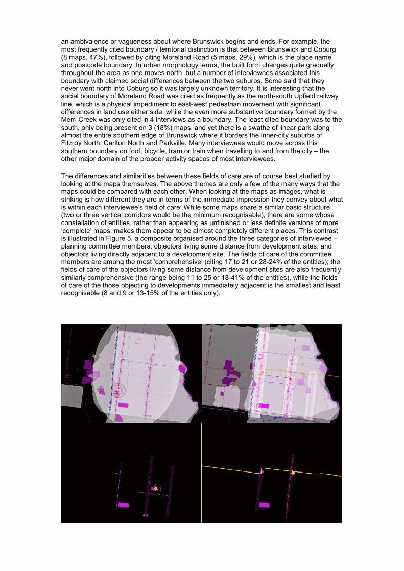
The differences and similarities between these fields of care are of course best studied bylooking at the maps themselves. The above themes are only a few of the many ways that themaps could be compared with each other. When looking at the maps as images, what isstriking is how different they are in terms of the immediate impression they convey about whatis within each interviewee’s field of care. While some maps share a similar basic structure(two or three vertical corridors would be the minimum recognisable), there are some whoseconstellation of entities, rather than appearing as unfinished or less definite versions of more‘complete’ maps, makes them appear to be almost completely different places. This contrastis illustrated in Figure 5, a composite organised around the three categories of interviewee –planning committee members, objectors living some distance from development sites, andobjectors living directly adjacent to a development site. The fields of care of the committeemembers are among the most ‘comprehensive’ (citing 17 to 21 or 28-24% of the entities); thefields of care of the objectors living some distance from development sites are also frequentlysimilarly comprehensive (the range being 11 to 25 or 18-41% of the entities), while the fieldsof care of the those objecting to developments immediately adjacent is the smallest and leastrecognisable (8 and 9 or 13-15% of the entities only).
Figure 5. Composite of residents’ ‘fields of care’ maps (clockwise from top left):Planning Committee members; Objectors living some distance from developmentsites; objectors immediately adjacent to development sites (2 separate maps). Seefigure 1 for legend.
Discussion
One of the telling aspects of these maps is the ways in which interviewees’ experience ofplace as fields of care can be represented. Clearly, the maps are as individual as people areand reflect the differences in the way people move around and live in a place. But what aboutthe comparison with the field of care, such as it is, produced by the planning system whenassessing development applications? The minimum legal requirement (where one exists atall) is that planning authorities notify adjacent owners of properties of developmentapplications. The official objection proforma asks objectors to answer the simple question‘explain how the proposal would affect you’. There is an implicit logic here about a field ofcare that the planning system can assess – the notion that there is only a material impact onpeople close enough to be directly affected that needs to be assessed as grounds forobjection. Planning officers have the discretion to extend this field of care beyond theadjacent properties however far they believe that residents might reasonably be affected by aproposal. Our ‘spider maps’ illustrate the degree to which such discretion was exercised inBrunswick and the extent to which planning officers’ perceptions of each developmentproposal’s potential field of care varied. They also show that in most cases, each resident’sfield of care regarding these sites was different – almost always objections came from a muchlarger area than the one set out for notifications, and often distributed in irregular ways ratherthan, say, a linear progression related to distance from a site. This is significant because itmeans that the residents’ field of care is effectively spatially inverse to the principles drivingthe planning assessment process. Although our sample size is small, if there is anything thatcan be said about the maps in relation to the planning issues, it is that the closer to thedevelopment site the objections come, the less concerns there are likely to be in terms ofbroader planning issues (neighbourhood character, how the wider suburb works as a place)and the more focussed on immediate impacts that may have little to do with the intent of goodplace-based planning.
In short, the planning policy of notifying only a very limited number of spatially proximateresidents may actually exacerbate the tendency of objectors to react as stereotypical NIMBYsand obscure the nuances contained in the fields of care of residents who care, but who liveoutside the area deemed worthy of notification by planning policy. To speculate further, whatwe see by comparing residents’ fields of care maps with the ‘spider maps’ of projects,notifications and objections is the potential for conflicts over whose field of care will prevail inplanning decisions. The semantic content of the interviews shows that what is contained inthese maps on another plane is residents’ sense of how the suburb works as a place and thecomplex assemblage of the material and the social from which their experience of its place-identity, or character, emerges (Woodcock et al 2009). These maps illustrate that residentsexperience could be drawn upon much better by the planning system to frame policy as wellas assess development applications than is currently the case.
ACKNOWLEDGMENTS
This paper is drawn from research conducted for a larger project titled ‘The character of urbanintensification: protecting and creating place-identity in activity centres’, funded by a LinkageGrant (LP0669952) from the Australian Research Council, the Victorian Department ofPlanning and Community Development and the cities of Melbourne, Moreland and Yarra. Weare grateful to the City of Moreland for extensive access to planning files for the base data onsources of objections.
REFERENCES
Dovey, K., Woodcock, I. and Wood, S. (2009a) Understanding Neighbourhood Character:The Case of Camberwell, Australian Planner 46 (3), 32-39
Dovey, K., Woodcock, I. and Wood, S. (2009b), A test of character: Regulating place-identityin inner-city Melbourne, Urban Studies 46 (12), 2595-2615

Woodcock, I., Dovey, K. and Wollan, S. (2009) Not in My Republic! Resident opposition tourban intensification in inner-city Melbourne, State of Australian Cities NationalConference
Massey, D (1994) A Global Sense of Place in in Massey, D. (ed.) Space, Place and GenderPolity Press, Cambridge
Tuan, Y.-F. (1974) Topophilia: A Study of Environmental Perception, Attitudes and Values,Columbia University Press, New York
Tuan, Y.-F. (1999) Space and Place in Humanistic Perspective in Agnew, J.& Livingstone, D.N. & Rogers, A. (eds.) Human Geography – An Essential Anthology, Blackwell Publisher ,USA
Wood, S., Woodcock, I. and Dovey, K. (2006) Contesting characters at Hedgeley Dene, inMcMinn, T., Stephens, S. and Basson, S. (Eds) Contested Terrains. XXIII AnnualConference of the Society of Architectural Historian, Australia and New Zealand(SAHANZ), Perth WA
Woodcock, I., Dovey, K.,Wollan, S. and Robertson, I. (2011) Speculation and Resistance:Constraints on Compact City Policy Implementation in Melbourne, Urban Policy andResearch, (forthcoming; published online 03 Jun 2011)