Embed Size (px)
Citation preview
Mapping Fires in the Mediterranean Basin
Causes and Patterns of a “Natural” Phenomenon
2nd International Symposium onLightning and Storm Related Phenomena
Aurillac, May 10-11 2017
Régis DarquesCNRS-UMR 5281 ART-DevMontpellier [email protected]
Basic information - Approach
1. This paper is not about lightning itself. My approach shall contrast with other contributions
2. As a geographer, my initial expertise area is territorial analysis, with special interest in environmental studies: Protection systems and fire development in sensitive areas, especially forests. Mediterranean Basin.
3. Engineering sciences: Mapping, GIS and remote sensing. Big data. Development of proprietary databases.
4. Focus on geographic interactions: Human vs physical geography, environment vs land planning, ecosystems vs anthroposystems, artificial (human induced) vs natural phenomena
– Interfaces: The interaction through space
– Geosystems : The interaction through concepts (what “builds” territories)
5. Lightning-related phenomena: Associated with risk analysis in the area of geography. This is not my position. Risk (high probability of occurrence) vs hazard (exceptionality/randomness).
Lightning and geography – A missed opportunity
1. I owe my presence here to Ray Piccoli. His invitation is due to a long common scientific collaboration and friendship.
2. The review of literature on this issue is almost non-existent
3. My work about lightning is still at any early stage of its development. Much is to be done, for many reasons, among which:
– Missing spatial databases, especially high resolution databases. Fragmented available information on different
areas of the globe. Paradox of nation-based VHF-VLF detection networks dedicated to transnational phenomenon
– Lightning is usually not considered as a spatial phenomenon. Most studies see lightning as a physical event
related to specific atmospheric/physical conditions. Its temporal immediacy implies a geographic non-existence
(GIS non-earth event). Disinterest of spatial sciences.
4. Purpose: Turning things upside down
– Dot maps. Dots have no area (mapping artifact, visual semiotics).
– Mapping is a priority, not only as a way of investigating a simple spatial distribution, but because mapping can
provide feedback information on the nature of lightning. GIS as a communication system (downstream) vs a
scientific analysis tool (upstream).
Towards a spatial approach – Mapping fires
1. As an example of land-lightning interaction, let’s focus on lightning-related (wild)fires
2. Direct approach is impossible by now (missing VHR databases) Circling approach: Studying a phenomenon through its effects
3. The rationale is based on the assumption that wildfires might be somehow related to lightning. Applies when specific conditions are met: Atmosphere, vegetation cover (arid, semi-arid ecosystems), human occupation (low density areas).
4. Easy logical relationship between fires and lightning (common myths). When fires are not human induced, we spontaneously suppose that woods burn because of a “natural” igniter: Lightning. Last resort explanation. Has to be demonstrated.
5. Scale dependency. We hypothesize that large-scale fires might be caused by micro-scaleCG flashes.
6. Systematic data acquisition is required to define spatial phenomena. This is only possible with up-to-date satellite imagery at a mid-scale level.
EFFIS statistics – Fire causes (1)
1. To investigate wildfire causes, one source: Official statistics provided by forest services. Risky operation. Variable quality: Methodology, reliability of public officials,… and political context (disruptions in data collection).
2. EFFIS=European Forest Fire Information System. Does not cover the entire Mediterranean Basin. Mistrust towards European databases (harmonization problems).
3. EFFIS procedure in identifying wildfire causes aims at improving data reliability. Erasing “guessed” causes through an improved investigation procedure. Targeted investigations are now required. Defining “certain” circumstances. Supposes that the ignition point of the fire has been found and the cause has been identified with no doubts.
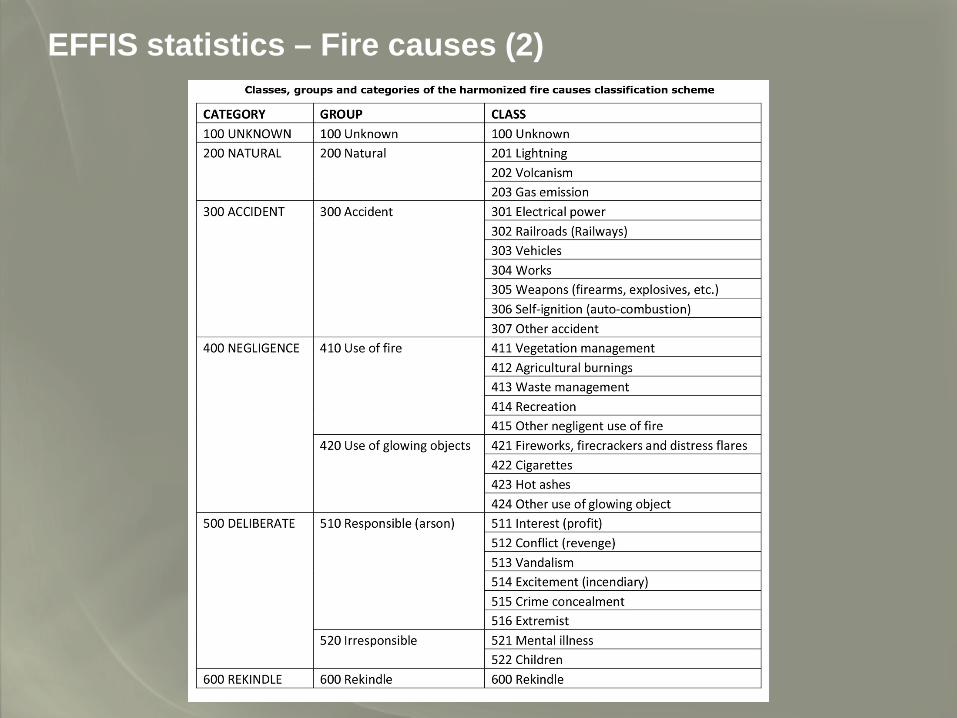
4. 29 fire cause classes, grouped into 6 generic categories
EFFIS statistics – Fire causes (2)
EFFIS statistics – Fire causes (3)
1. To be noticed:
a) Lightning is to be found in different classes: Unknown, natural, and accident
b) Sometimes, lightning is not registered per se, identified as a generic natural cause
c) Specific labelling: Natural disasters (Czech Republic), other natural causes (Finland), self-ignition/auto-combustion
(Finland), electricity or lightning (Hungary)
Hence a sense of confusion - information scattering. Porosity between classes.
1. Many statistical inconsistencies:
a) Italy: 60% of fires would be deliberate
b) Portugal: 85% of fires have no identified cause
c) France has no “unknown” category
What is certain: The importance of unidentified causes
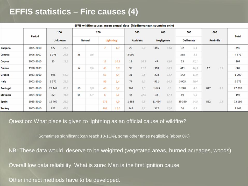
EFFIS statistics – Fire causes (4)
Question: What place is given to lightning as an official cause of wildfire?
Sometimes significant (can reach 10-11%), some other times negligible (about 0%)
NB: These data would deserve to be weighted (vegetated areas, burned acreages, woods).
Overall low data reliability. What is sure: Man is the first ignition cause.
Other indirect methods have to be developed.
Mapping (wild)fires in the Mediterranean Basin– Study area (1)
1. We won’t go into too much detail here (too long): 2 years long full-time work
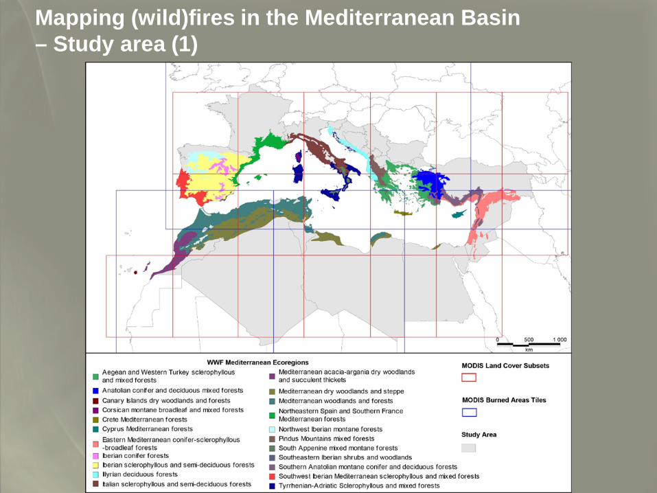
2. Study area: Mediterranean Basin. Known high sensitivity to wildfires, hot summer season, semi-arid vegetation, and frequent storms.
In short: 32 countries (defined by their political boundaries), covering the entire WWF Mediterranean Biome.
3-Data sources: NASA TERRA & AQUA MODIS.
a-2 databases are compared: MCD12Q1 (Land Cover Type) and MCD45A1 (Burned Area Product). Spatial resolution: 500m. High frequency of acquisition. Agglomerated data. NB: burned areas are identified and mapped through image comparisons (cover change), not through direct observations.
The first dataset (land covers) is more complex than the second one (burned areas). Vegetation covers are labelled through 12 categories (Plant Functional Type classification)
b-Data processing: complex algorithms
Mapping (wild)fires in the Mediterranean Basin– Study area (1)
Mapping (wild)fires in the Mediterranean Basin– Data sources (2)
1. MODIS satellite sensor (NASA TERRA & AQUA).
2. 2 databases are compared:
-MCD12Q1 (Land Cover Type)
-MCD45A1 (Burned Area Product)
-Spatial resolution: 500m. High frequency of acquisition. Agglomerated data. NB: burned areas are identified and
mapped through image comparisons (cover change), not through direct observations.
3. The first dataset (land cover) is more complex than the second one (burned areas). Vegetation is labelled with 12 categories (Plant Functional Type classification)
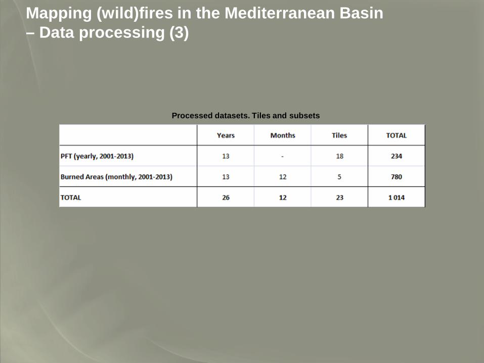
Mapping (wild)fires in the Mediterranean Basin– Data processing (3)
Processed datasets. Tiles and subsets
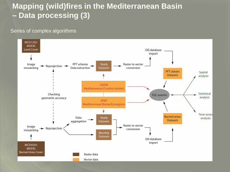
Mapping (wild)fires in the Mediterranean Basin– Data processing (3)
Series of complex algorithms
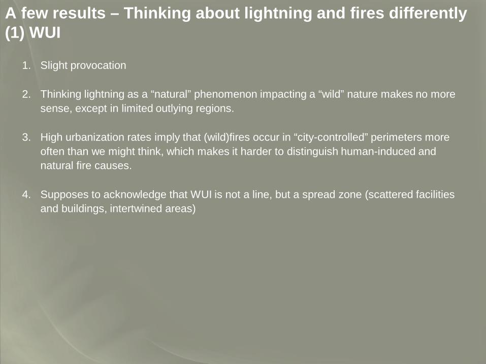
A few results – Thinking about lightning and fires differently(1) WUI
1. Slight provocation
2. Thinking lightning as a “natural” phenomenon impacting a “wild” nature makes no more sense, except in limited outlying regions.
3. High urbanization rates imply that (wild)fires occur in “city-controlled” perimeters more often than we might think, which makes it harder to distinguish human-induced and natural fire causes.
4. Supposes to acknowledge that WUI is not a line, but a spread zone (scattered facilities and buildings, intertwined areas)
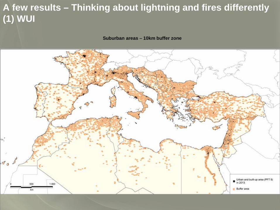
A few results – Thinking about lightning and fires differently(1) WUI
Suburban areas – 10km buffer zone
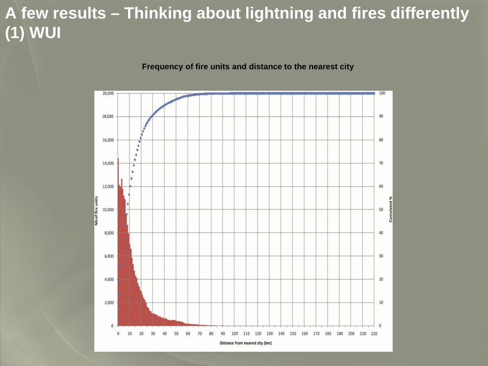
A few results – Thinking about lightning and fires differently(1) WUI
Frequency of fire units and distance to the nearest city
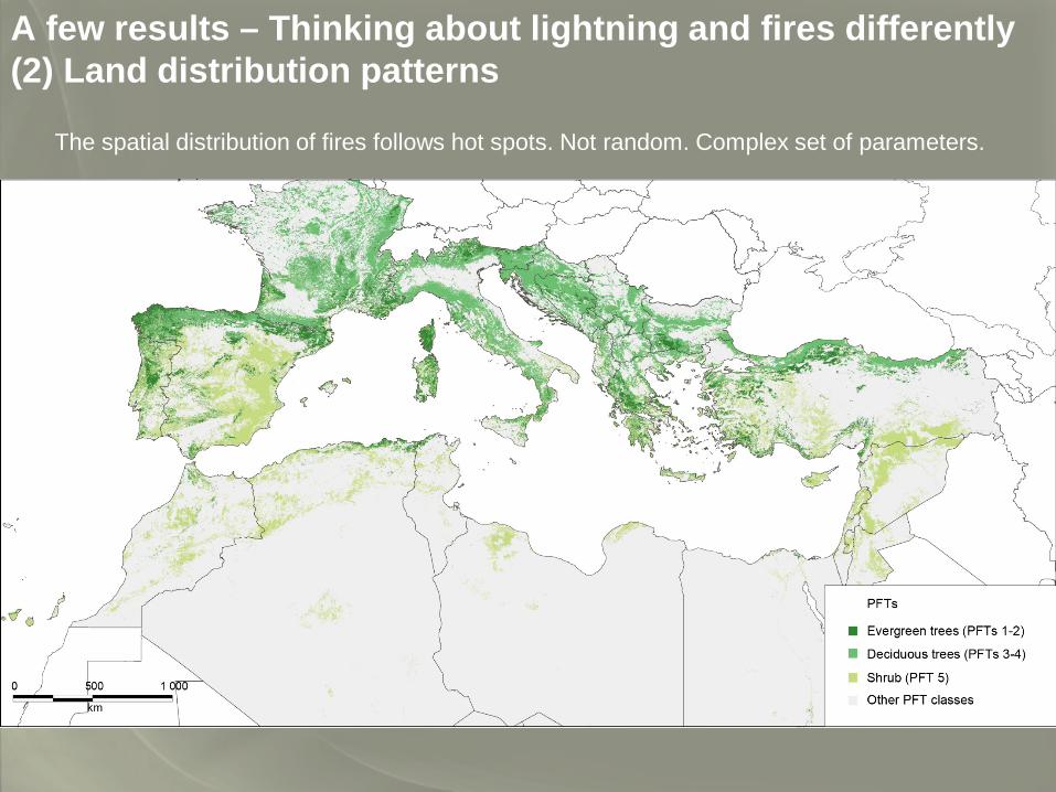
A few results – Thinking about lightning and fires differently(2) Land distribution patterns
The spatial distribution of fires follows hot spots. Not random. Complex set of parameters.
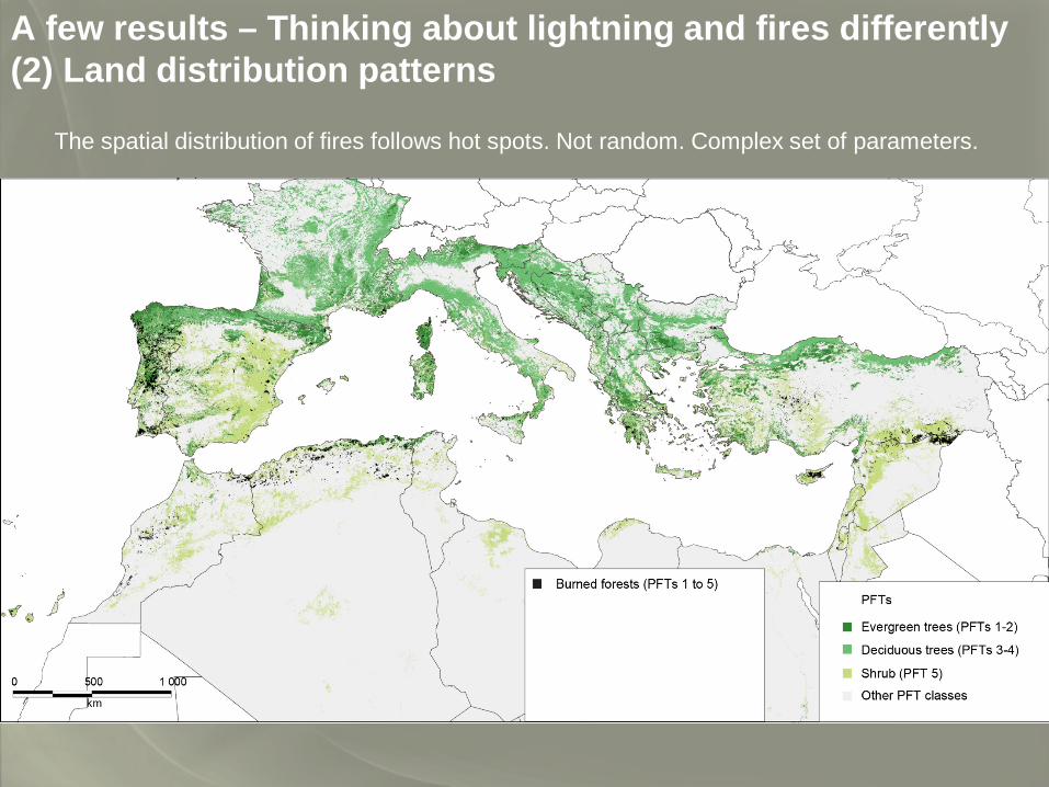
A few results – Thinking about lightning and fires differently(2) Land distribution patterns
The spatial distribution of fires follows hot spots. Not random. Complex set of parameters.
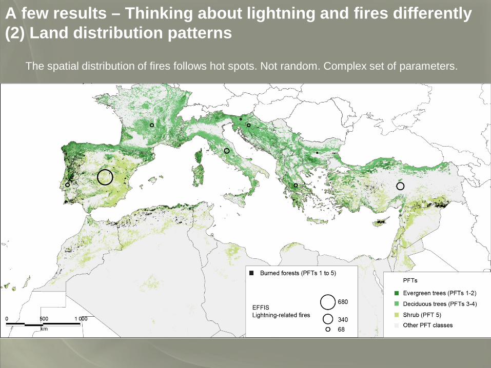
A few results – Thinking about lightning and fires differently(2) Land distribution patterns
The spatial distribution of fires follows hot spots. Not random. Complex set of parameters.
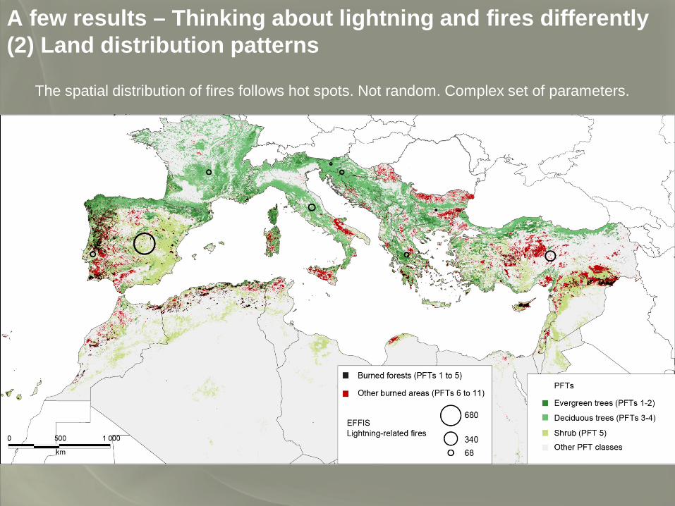
A few results – Thinking about lightning and fires differently(2) Land distribution patterns
The spatial distribution of fires follows hot spots. Not random. Complex set of parameters.
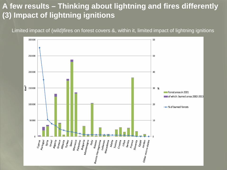
A few results – Thinking about lightning and fires differently(3) Impact of lightning ignitions
Limited impact of (wild)fires on forest covers &, within it, limited impact of lightning ignitions
Conclusion
Uncertainty prevails in a number of areas
Complex situation implying mobilizing various spatial resources. This complexity arises from both lightning and territories (interaction)
Assessing the role of lightning in “building” landscapes is a difficult task. Implies developing powerful databases able to promote a consistent understanding.
Much remains to be done…
Chi
cken