Embed Size (px)
Citation preview

AnthrovisionVaneasa Online Journal
4.2 | 2016
Imagination/Ineffability
Mapping Ararat: An Augmented Reality WalkingTour for an Imaginary Jewish Homeland
Louis Kaplan and Melissa Shiff
Electronic versionURL: http://journals.openedition.org/anthrovision/2339DOI: 10.4000/anthrovision.2339ISSN: 2198-6754
PublisherVANEASA - Visual Anthropology Network of European Association of Social Anthropologists
Electronic referenceLouis Kaplan and Melissa Shiff, « Mapping Ararat: An Augmented Reality Walking Tour for an ImaginaryJewish Homeland », Anthrovision [Online], 4.2 | 2016, Online since 31 December 2016, connection on19 April 2019. URL : http://journals.openedition.org/anthrovision/2339 ; DOI : 10.4000/anthrovision.2339
This text was automatically generated on 19 April 2019.
© Anthrovision

Mapping Ararat: An AugmentedReality Walking Tour for anImaginary Jewish Homeland
Louis Kaplan and Melissa Shiff
Introduction
Mapping Ararat port of entry augment
Shiff, Kaplan, Freeman, Mapping Ararat, 2012
1 Mapping Ararat: An Imaginary Jewish Homelands Project animates Major Mordecai Noah’s
bold plan of 1825 to transform Grand Island, New York into Ararat, a city of refuge for the
Jews. Utilizing the new technology of augmented reality, this project gives Ararat the
chance to become the Jewish homeland that its founder had envisioned but never
Mapping Ararat: An Augmented Reality Walking Tour for an Imaginary Jewish Hom...
Anthrovision, 4.2 | 2016
1

realized nearly two centuries later. Mapping Ararat exposes viewers to the contingencies
of history by plotting a counterfactual history that plays out this “what if” scenario on
the Ararat path not taken. In illuminating this alternative trajectory of modern Jewish
history, we are recalling that history is a construct of competing political desires and
wills which could have turned out quite differently. This collaborative research-creation
project is supported by a Social Sciences and Humanities Research Council of Canada
Insight Development Grant. The team consists of multimedia artist Melissa Shiff who
serves as principal investigator and project director; Louis Kaplan who serves as the chief
historian and theorist; and, new media artist John Craig Freeman (Emerson College,
Boston) who specializes in augmented reality in his creative practice.
Mapping Ararat synagogue augment
Video still of synagogue on the augmented reality walking tour.
Shiff, Kaplan, Freeman, Mapping Ararat, 2012
2 It is possible to think about the Mapping Ararat project as performing a type of
counterfactual ethnography for an imaginary community -- a group of inhabitants
(“Araratians”) that might have been if history had gone in another direction. At a
moment when there is a great deal of interest in emerging practices of visual
anthropology such as sensory ethnography (with its emphasis on art and “aesthetic-
sensual immersion”1 as well as on an embodied practice interested in mobility and the art
of walking) and imaginative ethnography (with its emphasis on the “recognition of
imagination and creativity as central and significant in human social relations”2), Mapping
Ararat in its creation of an imaginary Jewish homeland and its construction of an
augmented reality walking tour resonates with these two ethnographic currents even
though its roots are found in site-specific installation and locative media art. Similar to
Mapping Ararat, these ethnographic practices use performance, video, text, as well as
embodied and sensory experience in order to “lead us to a way of understanding the
multilayered nature of how place is constituted and the conflicting but entangled
perspectives from which places might be understood and experienced” (Pink 2008: 11).
Nevertheless, while these ethnographic practices focus in particular on how actual places
are constituted, the introduction of augmented reality involves the superimposition or
Mapping Ararat: An Augmented Reality Walking Tour for an Imaginary Jewish Hom...
Anthrovision, 4.2 | 2016
2

the blending of an imaginary or virtual space (Ararat) with an actual locale (Grand Island)
to generate a hybrid reality.
Phantasmatic Jewish Tourism
Mapping Ararat flag augment
Video still of flagpole on the augmented reality walking tour.
Shiff, Kaplan, Freeman, Mapping Ararat, 2012
3 Mapping Ararat constructs an augmented reality walking tour that embeds 3D computer
graphics modeled in the Maya and Rhino software programs into the everyday landscape
at the very sites where Mordecai Noah plotted and projected his Jewish homeland on the
banks of the Niagara River outside of Buffalo, New York. With smart phones in hand,
visitors are able to divine, locate, and navigate architectural landmarks (e.g. synagogue)
and symbols (e.g. flag) that are built to scale. These so-called assets are viewed on the
screen of a mobile phone or a tablet device using the publicly available Layar application
that relies on the use of geo-locational technology (GPS) to enable a site-specific mapping
of Ararat with exact cartographic coordinates. These assets are not in the physical
landscape; instead they are housed on a server and inserted into the landscape, so that
our fictive Jewish homeland unfolds onscreen at these very sites. The result is an
excursion in media geography that highlights the mediated aspects of AR tourism (Döring
and Thielmann, 2008).
Mapping Ararat: An Augmented Reality Walking Tour for an Imaginary Jewish Hom...
Anthrovision, 4.2 | 2016
3

Mapping Ararat gravestone augments
Video still of gravestones on the augmented reality walking tour.
Shiff, Kaplan, Freeman, Mapping Ararat, 2012
4 In this way, augmented reality provides a window into an imaginary dreamscape (as seen
through the iPad or the iPhone) where counterfactual visions are superimposed over
reality. In posing this parallel universe and hybrid reality, Ararat’s electronic monuments
conjure the Jewish phantoms that are haunting the contemporary landscape of Grand
Island. We take the view that augmented reality is a fantastic and phantasmatic medium
-- one that opens up alternatives through which we encounter the ghosts and specters of
things that might have been or that still might be yet to come. Here, the mobile camera
phone functions not as a transparent window on the world or as a magic mirror reflection
but rather as a spectral refraction that points to paths that were not taken but that are
still haunting the scene. The exposure of such Jewish ghosts on Grand Island through the
construction of these electronic monuments parallels Sarah Pink’s study of “place
making” and her astute observation that attending to different routes and mobilities in
local visual culture “can reveal important ethnographic insights in how urban places are
constituted and contested” (2008: 11).
5 In the description for the workshop “Mining Imagination: Ethnographic Approaches
Beyond Knowledge Production,” convener Michaela Schäuble (2013) reminded the
participants that the filmic medium has “from its inception been used to explore the
invisible and imagined dimensions of human life ‘as if real.’”3 The exact same thing can be
said of the new media technology of augmented reality as it has been deployed in the
Mapping Ararat project. What a peculiar phenomenon it is to behold the “augmented
reality effect” and then to have this effect exposed in a way that pierces the veil of Maya
and reveals that it is an illusion.
6
This media file cannot be displayed. Please refer to the online document http://
journals.openedition.org/anthrovision/2339
https://vimeo.com/95792460
Mapping Ararat: An Augmented Reality Walking Tour for an Imaginary Jewish Hom...
Anthrovision, 4.2 | 2016
4

7 In other words, one invests in the illusionism of the augment that has been inserted into
the space of the real only to have the carpet pulled out from under one’s mobile
electronic device. One is left hanging in the space that has been abandoned by the
computer graphics rendered (appropriately enough) in the software program Maya. The
augments split the scene of visual representation and vanish into invisibility. Indeed, the
exploration of imagined dimensions as if they were real is at the core of this augmented
reality project given that Mapping Ararat plots and superimposes the imaginary Jewish
homeland of Ararat onto Grand Island, New York as if it were real.
Mapping Ararat Sochi Olympic augment
Screen shot of Sochi Olympic billboard with Ararat tourist on the augmented reality walking tour.
Shiff, Kaplan, Freeman, Mapping Ararat, 2012
8 The AR walking tour transports tourists to the nondescript “non-place” of Grand Island
for a participatory and interactive experience where one playfully activates and conjures
the imaginary Jewish homeland of Ararat. Each augment (or asset) that one encounters
on the walking tour may be viewed as an electronic monument, building, or landmark.
Here, Mapping Ararat draws upon the work of the digital cultural theorist Gregory Ulmer
(2005) who invokes the idea of electronic monumentality that has been made possible by the
internet and by digital media in general. For Ulmer, electronic monuments are the way by
which commemoration reemerges in contemporary society and they do this by
constructing a virtual public sphere. As Ulmer puts it in the “Introduction” to this book:
“The hypothesis of electronic monumentality is that commemoration is a fundamental
experience joining individual and collective identity, which must be adapted in any case
to the emerging apparatus of electracy. […] Electronic monumentality provides the basis
for a virtual public sphere.” (xxi). In a more recent article by Ulmer written in
collaboration with John Craig Freeman (2014), they discuss how accessing the virtual
Mapping Ararat: An Augmented Reality Walking Tour for an Imaginary Jewish Hom...
Anthrovision, 4.2 | 2016
5

public sphere is crucial to augmented reality art interventions in particular. “Public
discourse has been relocated to a novel space: a virtual space that encourages exploration
of mobile location-based art in public” (61). Whether taking the form of a virtual
synagogue or a port of entry, each of the augments constructed for our project bear
witness to and fulfill the need for both public recognition and commemoration of the
Ararat alternative. Such a walking tour with its reliance on locative media allows for a
site-specific use of AR technology to advance the pedagogical and artistic ends of the
project.
Mapping Ararat augmented reality walking tour map
Shiff, Kaplan, Freeman, Mapping Ararat, 2012
9 The site-specific nature of the tour also resembles a treasure hunt as participants receive
a map that marks the places where they must search for and find the augments. Each
thumbnail-sized icon has been created from a birds-eye view render of the 3D Maya
model. The augmented reality walking tour consists of twenty-four visual attractions in
total. Each point of interest has an accompanying audio file that provides the virtual
tourist with information about that particular site mixing fact and fiction in a multi-
layered soundscape.
Mapping Ararat: An Augmented Reality Walking Tour for an Imaginary Jewish Hom...
Anthrovision, 4.2 | 2016
6

Burr’s Atlas 1829
Detail of the County of Erie showing “Arrarat” as an actual geographic location, 1829.
David H. Burr ; engd. by Rawdon, Clark & Co., Albany, & Rawdon, Wright & Co., New York (1829).
10 This tourist map also alludes to an important historical artifact that is pivotal to Mapping
Ararat and its goal of remembering an imaginary Jewish homeland on Grand Island and
that also underscores an important cartographic aspect of the project. It shows us the
archival map of Grand Island that was published in David H. Burr’s Atlas of the State of New
York in 1829. Grounding our project in a specific geographical location, Burr’s Atlas lists
Arrarat -- spelled with 3 r’s -- as an actual place. This map and its placement of Ararat on
the north east side of the Island has enabled us to root our imaginary Jewish homeland
and augmented reality walking tour in a specific physical site. In this way, our locative
media project uses the area on the map now known as Whitehaven as the precise location
for the AR walking tour.
11 Augmented reality generates a new form of virtual tourism that brings cyberspace back
into real space. On the augmented reality walking tour, tourists often “divine” for the
augments by waving their I-phones or I-pads in the figure-8 motion of calibration until
they are tracked down and appear on the screen when they are fully registered. The
screenshot function of the Layar program also enables a type of virtual photography that
allows users to pose with the augments as they are superimposed onto real space. In this
way, they are able to document their interactions with the Ararat artifacts or monuments
that have been inserted into the Grand Island landscape. This screenshot function also
allows for the circulation and distribution of these tourist shots to both friends and
family via e-mail or posting them to social media websites. In this regard, they follow the
model of photographic digitization sketched by John Urry and Jonas Larsen in their
informative study The Tourist Gaze 3.0 (2011). As the authors write, “Many personal
Mapping Ararat: An Augmented Reality Walking Tour for an Imaginary Jewish Hom...
Anthrovision, 4.2 | 2016
7

photographic images are now destined to live virtual, digital lives without material
substance, in cameras, computers and on the internet. Emails, blogs and social
networking sites dislocate photographic memories from the fixed physical home and
object-ness, distributing them to desktops, folders, printers, photo paper, frames – or
trash bins” (156). It is interesting to note how these authors stress the dislocation of such
touristic images and their removal from a “fixed physical home and object-ness” as a
hallmark of digital photographic memories. This characterization is most applicable for a
description of the virtually mediated tourist mementos that are taken in the imaginary
and deterritorialized Jewish homeland of Ararat.
12 The virtual tourist photographs that are shot in “Ararat” are linked to the countless
images of tourists documenting their visits to exotic places, heritage sites, and historical
landmarks around the world using snapshot photography. However, they also display a
major difference from conventional tourist photographs in that they illustrate how
humans increasingly inhabit their world at a distance in the digital era. In offering an
example of virtual tourism, Mapping Ararat illustrates how mediation and distanciation
overtake the space of immediacy and presence in terms of a touristic experience. This is
reflected not only in terms of the technological mediations that one encounters on the AR
walking tour (the experience of the tour as mediated via the screen of the mobile phone
or tablet) but also in terms of these screenshots generating a new type of virtual
photography. These aspects conform to and confirm Urry and Larsen’s reflections on
digital photographs as “a crucial component of mobile-networked societies of
distanciated ties and screened sociality” (Urry and Larsen 2011: 186).
13 The Ararat screenshots are also closely akin to the tradition of humorous fabricated
photographs staged in photo studios where people playfully pose with props “as if” they
are flying in an airplane or driving a car. It is important to recall that this playful “as if”
element is at the root of the positing of any counterfactual history. The superimposition
at the crux of the screenshot also bears a direct relationship to the practice of
photomontage and its contestation of photographic truth and it also recalls
photomontage’s often biting sense of humor. For instance, one recalls the comic series of
postcards (ca. 1906) that depict London as if it were Venice. Again, the principle played
out here is similar to our own imaginary Jewish homeland that sees Grand Island as if it
were Ararat. The AR walking tour transforms participants into actors, photographers,
and directors who become immersed in getting just the right shot and in framing their
screenshots in order to give the illusion of realism and to capture the (augmented) reality
effect.
Mapping Ararat: An Augmented Reality Walking Tour for an Imaginary Jewish Hom...
Anthrovision, 4.2 | 2016
8
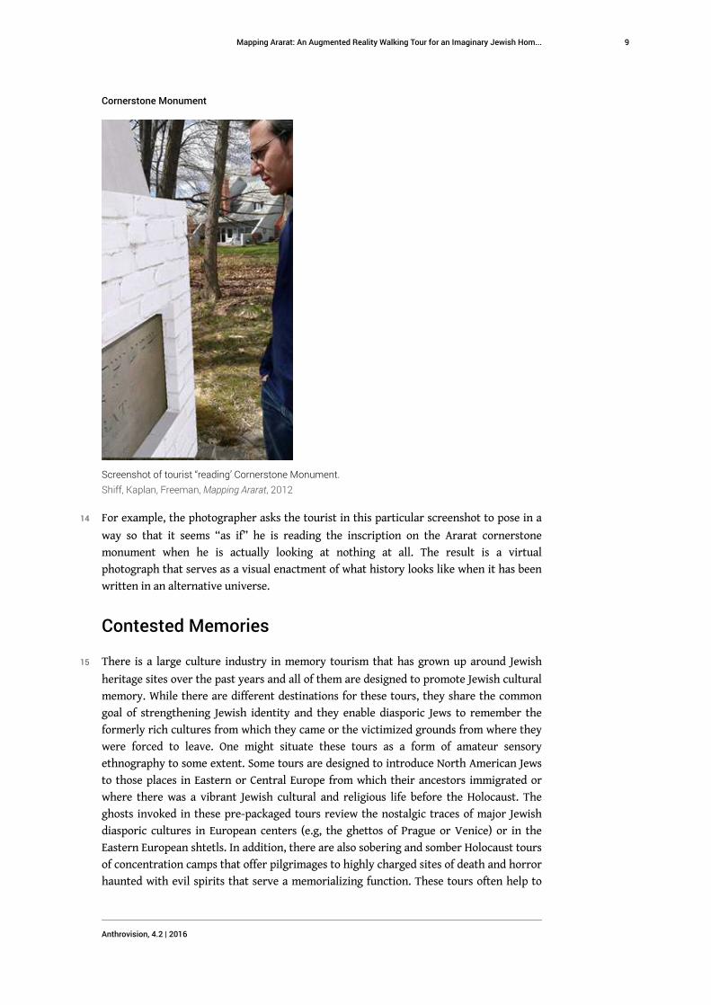
Cornerstone Monument
Screenshot of tourist “reading’ Cornerstone Monument.
Shiff, Kaplan, Freeman, Mapping Ararat, 2012
14 For example, the photographer asks the tourist in this particular screenshot to pose in a
way so that it seems “as if” he is reading the inscription on the Ararat cornerstone
monument when he is actually looking at nothing at all. The result is a virtual
photograph that serves as a visual enactment of what history looks like when it has been
written in an alternative universe.
Contested Memories
15 There is a large culture industry in memory tourism that has grown up around Jewish
heritage sites over the past years and all of them are designed to promote Jewish cultural
memory. While there are different destinations for these tours, they share the common
goal of strengthening Jewish identity and they enable diasporic Jews to remember the
formerly rich cultures from which they came or the victimized grounds from where they
were forced to leave. One might situate these tours as a form of amateur sensory
ethnography to some extent. Some tours are designed to introduce North American Jews
to those places in Eastern or Central Europe from which their ancestors immigrated or
where there was a vibrant Jewish cultural and religious life before the Holocaust. The
ghosts invoked in these pre-packaged tours review the nostalgic traces of major Jewish
diasporic cultures in European centers (e.g, the ghettos of Prague or Venice) or in the
Eastern European shtetls. In addition, there are also sobering and somber Holocaust tours
of concentration camps that offer pilgrimages to highly charged sites of death and horror
haunted with evil spirits that serve a memorializing function. These tours often help to
Mapping Ararat: An Augmented Reality Walking Tour for an Imaginary Jewish Hom...
Anthrovision, 4.2 | 2016
9

define Jewish identity in terms of past victimhood and they set up a narrative where the
ultimate destination and destiny is identification with the land of Israel and Zionist
nationhood.4 Other Jewish heritage tours go to Israel directly in order to affirm the holy
land as Jewish place of origin, homeland, and nation-state. In contrast, our Ararat
augmented reality walking tour stands at the dawn of a new era of Jewish virtual tourism
as the Ararat tourists engage with these apparitional augments in a site-specific and an
embodied way.
16 This image mimes the typical Tourist Information Centre that one finds on any road trip
but while there is a big blue and gold sign, there is no actual referent here.
Ararat Welcome Sign augment
Screenshot of visitors on the augmented reality walking tour.
Shiff, Kaplan, Freeman, Mapping Ararat, 2012
17 Freeman and Sheller (2015) stress the importance of the production of affect in digital
public art projects. They refer to “affective atmospheres” that “are elicited by concrete
assemblages of digitally mediated encounters in diverse physical spaces, at once private
and public.” (5). As a digitally mediated encounter, the Mapping Ararat augmented reality
walking tour generates an affective atmosphere that thrives on ambivalence as it induces
a self-ironic sense of nostalgia in its participants/users as well as a “provocative
awareness” of how this space could be imagined otherwise. This mode of Jewish virtual
tourism helps people to identify Jewishly and even feel a strong sense of nostalgia but for
a place that they or their ancestors never left, a place that never was but might have
been. (This virtual initiative can be referred to as “Birthright Ararat.”5) Indeed, the AR
walking tour is founded on an ironic type of nostalgia -– namely, the remorse and regrets
felt over the loss of a Jewish homeland that might have been but that never was.
Experiencing these apparitional augments in such a site-specific and an embodied way
Mapping Ararat: An Augmented Reality Walking Tour for an Imaginary Jewish Hom...
Anthrovision, 4.2 | 2016
10

exposes the affective power of the project as well as its poignancy. In this way, the
Mapping Ararat mobile app stages both a sentimental journey and a moving experience.
Nevertheless, it is also important to recall that the “non-place” of Ararat -- set up as this
visual mirage -- is also the self-ironic source of the humor that pervades this project in
contested memories. Thus, the nostalgia for home is offset by the deterritorializing plays
opened up by plotting this Jewish homeland in cyberspace reminding us that the
impossibility of utopia (as no place) is often a cause for laughter as the mobile device is
pulled away to reveal that nothing is really there.
Ararat Port of Entry augment
Screenshot of Rabbi Tanenbaum at the Ararat Port of Entry.
Shiff, Kaplan, Freeman, Mapping Ararat, 2012
18 In another humorous interaction between real and virtual space, this image shows local
Rabbi Irwin Tannenbaum smiling after having just “entered” the Ararat port of entry.
This playful even game-like activity where the interactive tourist imagines himself an
alternate world stands in stark contrast to the morbidity invoked by the Holocaust
concentration camp tour that subjects tourists to the passive absorption of the horror. In
“Pilgrimage, Reenactment, and Souvenirs: Modes of Memory Tourism,” Marita Sturken
(2013) defines memory tourism as “a rite of mediated return through which tourists […]
create an experience of memory” (281). In Mapping Ararat, we also encounter a case study
in memory tourism but one of a virtually mediated kind. While Sturken talks about how
“architectural designs, memorials, and museum displays deploy reenactment strategies
to evoke memories (281),” our project generates electronic monuments on the AR
walking tour to create experiences of contested memory that transforms the contours of
the past. As you can see from this image juxtaposition on the AR walking tour the
Sovereign Nation of Ararat counter-monument and its alternative history shadows the
Mapping Ararat: An Augmented Reality Walking Tour for an Imaginary Jewish Hom...
Anthrovision, 4.2 | 2016
11

actual marker for tourists on Grand Island who can learn about the Whitehaven
Settlement (1834-1849).
Ararat Sovereignty Marker Augment
Screenshot of Sovereignty Marker augment juxtaposed with actual Whitehaven Settlement HistoricalMarker
Shiff, Kaplan, Freeman, Mapping Ararat, 2012
19 This historical episode occurred immediately after Major Noah and his associates sold off
the land to a company from East Boston who built a large timber mill on the former site
of Ararat.
Mapping Ararat: An Augmented Reality Walking Tour for an Imaginary Jewish Hom...
Anthrovision, 4.2 | 2016
12

Ga-We-Not Sovereignty Marker
Screenshot of Ga-We-Not Sovereignty Marker augment marking the restoration of Grand Island to theSeneca Nation.
Shiff, Kaplan, Freeman, Mapping Ararat, 2012
20 On the other hand, we have constructed another augment on the walking tour to
introduce the more troubling aspects of the aboriginal question and to raise the Native
American ghosts haunting Grand Island as well. In this case, we have placed a second
plaque next to the actual historical one in Whitehaven that commemorates Noah’s Ararat
plan placed by the Town of Grand Island in 1978. This Seneca nation augment functions as
an electronic counter-monument that tells the story of the same island as a Native
American settlement and in line with another historical claim. In this way, visitors can
begin to conjure a parallel aboriginal world in another alternative universe. The
construction of this augment takes us into the heart of the contested cartographies and
memories raised by Mapping Ararat. It is fascinating to recall in this context that the
Seneca nation actually filed a land claim in United States District Court as recent as 1993
to reclaim Grand Island and several smaller islands in the Niagara River on the grounds
that they were taken illegally from the tribe by the State of New York. The legal
wrangling would occupy the next dozen years until the Supreme Court refused to hear
the final Seneca appeal on June 5, 2006. To imagine the Seneca nation’s counterfactual
history of what they called Ga-we-Not or the Great Island troubles the unconscious of
Ararat and contests any utopian fantasy of it as a tabula rasa. The plaque reads: “Ga-We-
Not Restoration Act Declaration of National Sovereignty June 22, 2002. We the Seneca
Nation Reclaim Ga-We-Not From the American Occupiers and Restore These Ancient
Hunting and Burial Grounds on our Native Land.”
Mapping Ararat: An Augmented Reality Walking Tour for an Imaginary Jewish Hom...
Anthrovision, 4.2 | 2016
13

Further Ethnographic and Artistic Implications
21 Our project possesses certain affinities with the practice of sensory ethnography with its
focus on such aspects as emplacement, embodied activities (e.g. walking and eating),
sensory perception, and a type of affective “knowing” that cannot be expressed in words.
It is also interesting to note in this context that one of the innovative and favorite multi-
sensorial research methods of sensory ethnography is “walking with others” (Pink 2009:
76). While many recent ethnographic case studies involve taking walks with inhabitants
or sound walks in an immersive environment, our project consists of taking walks with
mobile media in hand and on ear in order to locate and recover the imaginary realm of
Ararat via augmented reality. In this regard, augmented reality can be viewed as one of
many “medial manipulations as means of tracing, evoking, and (re)presenting embodied
experiences” (Schäuble 2013). It might be said that Mapping Ararat affords another “way
of walking.” On the AR walking tour, the “actual ground of lived experience” (Ingold and
Vergunst 2008: 2) has been augmented by an interactive experience that contains oneiric
visions of what this ground might have yielded if it had taken shape as Ararat. These
walks also allow for a great degree of social interaction and bonding as people share their
experiences and as the tour stimulates conversation and debate about the political and
social issues that are raised by the project and their contemporary relevance.
Noah’s Ark Theme Park Augment
Screenshot of University at Buffalo students posing next to the Noah’s Ark Theme Park Augment.
Shiff, Kaplan, Freeman, Mapping Ararat, 2012
22 We also have conducted successful on-site tours with different classes from the
University at Buffalo. These guided experiences show the viability of AR walking tours as
a pedagogical device that plays to the mobile technological habits of a generation of
digital natives who have been raised on adventurous software applications and video
games.
Mapping Ararat: An Augmented Reality Walking Tour for an Imaginary Jewish Hom...
Anthrovision, 4.2 | 2016
14

Cornerstone Monument Augment
Video still of Cornerstone Monument as seen on the augmented reality walking tour.
Shiff, Kaplan, Freeman, Mapping Ararat, 2012
23 Furthermore, the Mapping Ararat augmented reality walking tour as guided by GPS
technology also resonates with that genre of art that features walking and mapping as
central to their interactive performance and that turns contemporary artists into digital
cartographers. As Karen O’Rourke (2013) writes, “When GPS technology came of age in
the mid-1990’s, artists had been using trajectories down here on earth to trace maps for
many years. Today the convergence of global networks, online databases, and new tools
for location-based mapping coincides with a renewed interest in walking as an art form”
(xvii). As the location-based augments come into view on our tourists’ I-phones and
tablets, our project turns walking Grand Island into the art form of Mapping Ararat. There
are many parallels in particular between Mapping Ararat and the work of Canadian artist
as cartographer Janet Cardiff who is well known for devising site-specific audio walks
such as Her Long Black Hair (2004) designed for a walk through New York’s Central Park.
This forty-six minute audio tour gives the participant a CD audio player, a map, and a set
of snapshots by which to navigate a particular route and to engage with its sites, sounds,
and memories. The Mapping Ararat AR walking tour shares some of the same techniques
and objectives as Cardiff’s project but now the hand-held mobile device that features the
insertion of augments into real space has supplanted the photographic snapshots in
opening up new interactive possibilities. All in all, the AR walking tour offers the way by
which site-specific and interactive installation art enters into the digital era. As Christine
Ross (2009) remarks, “In the field of art, AR environments are, effectively, a derivative of
site-specificity installation art in which site is de/un/respecified by the activation of
computer generated data.”
Mapping Ararat: An Augmented Reality Walking Tour for an Imaginary Jewish Hom...
Anthrovision, 4.2 | 2016
15

Title page, Where To? Exhibition
Mapping Ararat Synagogue Augment as seen on the title page of Where To? exhibition website.
Shiff, Kaplan, Freeman, Mapping Ararat, 2012
24 Given that the thrust of this project is the playful positing of an alternative Jewish
homeland in Ararat, it was selected (while it was still a work in progress) to be part of the
Where To? exhibition curated by Udi Edelman at the Israeli Center for Digital Art in Holon
in spring 2012. This group exhibition (featuring Michael Blum, Ariella Azoulay, and Yael
Bartana among others) allowed artists and historians to tap into modern Jewish cultural
memory and Israeli state archives in order to imagine possible roads not taken for the
establishment of a Jewish homeland in light of the contested circumstances of the
present. The curatorial statement reads: “Through the exhibited works and the historical
materials gathered for the exhibition, we suggest reintroducing these forgotten currents
and ideas to the public discourse, bringing the ‘losers’ of history to the center of the
stage, and once again presenting the question of Jewish existence as a current problem
that remains unsolved” (Edelman, Danon, Kasmy-Ilan, 2012). One can see how this
statement supports artistic and historical work that questions officially sanctioned
memory and that poses alternatives that have been subjugated. In a political landscape
full of anxieties about the sustainability of Zionism based in the holy land or critical of its
abuses of power in relation to the Palestinian population, it is easy to see why the Mapping
Ararat project would resonate in Israel among post-Zionists and others seeking political
and aesthetic alternatives. Thus, the curators selected the Ararat virtual synagogue as the
on-line banner for the entire exhibition. By recalling the 1825 plan for the Jewish
habitation of this space on the border between the United States and Canada, Mapping
Ararat reopens the debate over the proper/improper place for the Jews to be at home.
Mapping Ararat: An Augmented Reality Walking Tour for an Imaginary Jewish Hom...
Anthrovision, 4.2 | 2016
16

Tour Highlights
25 Let us review in this final section four points of interest as highlights on the augmented
reality walking tour in order to see how the ambulatory participants on Grand Island
navigate and interact with traces, evocations, and representations of the imaginary realm
of Ararat. These four audio-visual clips demonstrate how, with I-pads and tablets in
hands, we are using the technology of augmented reality to chart an imaginary Jewish
homeland and to engage the public with a fascinating chapter of modern history in a
sensory, embodied, and interactive manner. In summation, they illuminate how Mapping
Ararat can be understood as part of a larger discourse suggesting that there is more to the
touristic gaze than what meets the eye alone. In other words, the Ararat AR walking tour
with its multi-media and multi-sensorial components rethinks “the concept of the tourist
gaze as performative, embodied practices, highlighting how each gaze depends upon
practices and material relations as upon discourses and signs” (Urry and Larsen, 2011:
14-15).
26 1. Cornerstone Monument. Grounded in a weighty piece of actual history, Mapping Ararat
begins with the three hundred pound cornerstone that Noah ordered from Cleveland
Ohio and that played a pivotal role in the Ararat Proclamation Ceremony held at St. Paul’s
Episcopal Church in Buffalo on September 15th, 1825. It is the only relic that remains from
Mordecai Noah’s ambitious endeavor to create a Jewish homeland on Grand Island, and
the artifact is currently housed at the Buffalo History Museum where our team made a
pilgrimage at the beginning of the project. During our archival research, we discovered
an illustration that was published in a book dated from 1841 that depicts the brick and
wooden obelisk constructed to house the cornerstone as a mid-nineteenth century tourist
attraction.6 We also know from historical evidence that President John Q. Adams
disembarked to see the cornerstone monument on a sightseeing trip in 1843.7 That 1841
drawing was then rendered using the 3D modeling program Maya and uploaded to a
server. In this way, the Mapping Ararat project has restored the cornerstone and
reanimated it for a touristic use such that it has become a virtual tourist attraction for a
digital era.
27
This media file cannot be displayed. Please refer to the online document http://
journals.openedition.org/anthrovision/2339
https://vimeo.com/59058539
28 2. Flag. The Ararat flag is one of the simulations of statehood that has been created for the
project in order to mime the emblematic symbols and trappings of national authority.
(Other material artifacts include the production of stamps and money.) The design of the
flag foregrounds a white dove as the symbol of peace on a blue background and with the
Star of David in its mouth as the symbol of Jewish community. It also references the
Biblical story of the ark that so fascinated Mordecai Noah. One recalls that Noah sent out
a dove during the flood when seeking dry land and that the dove returned to him with an
olive branch from Mount Ararat where the ark landed (Genesis, Chapter 8, Verse 11). In
this way, the flag also maintains the associations of refuge that are keeping with Noah’s
vision of Ararat. The flag exists in two different visual registers as it moves between a
material artifact and a virtual augment. We have placed the flag in its augmented form on
Mapping Ararat: An Augmented Reality Walking Tour for an Imaginary Jewish Hom...
Anthrovision, 4.2 | 2016
17

the flagpole that is near the port of entry where it proudly waves and welcomes visitors
to the shores of the island.
29
This media file cannot be displayed. Please refer to the online document http://
journals.openedition.org/anthrovision/2339
https://vimeo.com/59004320
30 3. Synagogue. This video clip documents the long approach to the Ararat synagogue
augment on the walking tour. Like the other augments on the tour, this three-
dimensional synagogue is built to scale so that one can navigate around it or even go
“inside” this particular virtual structure. Mapping Ararat is quite different from most
academic uses of augmented reality that involve the reenactment of events or the
reconstruction of historic buildings having their basis in things that actually existed.8 In
contrast, Mapping Ararat occupies a more hypothetical space given that it speculates and
extrapolates from an actual proposal that never came to fruition. The construction of the
Ararat synagogue offers a good case study of this mode of extrapolation in that it is based
on architectural designs in upstate New York as well as synagogue designs in New York
City from the same foundational period during the first half of the nineteenth century.
Jumping to the present, the synagogue and the virtual contours of Ararat contest the
contemporary use of this particular site. The Ararat synagogue is sited at the edge of the
eighteenth green of the River Oaks Golf course in Grand Island. This means that
worshippers have to watch out for flying golf balls if they want to go “inside” the virtual
structure. This real life hazard provides an excellent example of the surreal
juxtapositions that ensue when creating tourist attractions on the augmented reality
walking tour.
31
This media file cannot be displayed. Please refer to the online document http://
journals.openedition.org/anthrovision/2339
https://vimeo.com/59005199
32 4. Gravestones. The next example parallels the cornerstone monument given that it has a
basis in actual history as well. Based on the actual 1875 drawing of Mordecai Noah’s
gravestone by artist A.H. Nieto (Karp 1987), it has been inserted into Grand Island’s
Whitehaven Cemetery. This is a decidedly Christian cemetery at the epicenter of where
Ararat would have been according to Burr’s Atlas of 1829. With this transplantation, we
have repatriated Noah’s gravesite relocating it from the Shearith Israel Cemetery in New
York to the imaginary Jewish homeland of Ararat.9 In so doing, we also have converted an
actual monument into an electronic monument. In addition to the founder’s gravestone,
there are two others of this type on the AR walking tour. These are the gravestone
augments constructed for Noah’s wife Rebecca and for his youngest son Lionel. The
tombstone for Lionel Noah poses genealogical questions along the path of Ararat’s
counterfactual history. These alternative possibilities are raised in the audio track for
Lionel Noah’s gravestone on the walking tour as it moves between historical fact and
fantasy. The text alludes to the fact that Lionel named his son Lionel Jr. in an act of
assimilation directly opposed to the Jewish practice of naming one’s children only after
deceased ancestors and thereby honoring their memories. Coincidentally, it turns out
that Lionel Jr. repeated the same gesture in the next generation by naming his son Lionel
Mapping Ararat: An Augmented Reality Walking Tour for an Imaginary Jewish Hom...
Anthrovision, 4.2 | 2016
18

Jr. too. In divining the Jewish ghosts of Grand Island, the placement of this tombstone in
Ararat imagines an alternative history where Jewish naming practices would have
foreclosed this possibility leading to a very different outcome.
33
This media file cannot be displayed. Please refer to the online document http://
journals.openedition.org/anthrovision/2339
https://vimeo.com/112770976
34 The visit of some of the descendants of Noah’s youngest son Lionel to Grand Island in May
2014 captures the poignancy of our project. In this field trip to “Ararat”, Mordecai Noah’s
great-great-great-great grandchildren (both of whom are Christian) pose in front of their
ancestors’ virtual graves. In this speculative manner, Noah’s actual descendants occupy
the space of contested memories and imagine an alternative history for themselves. Such
an image raises the counterfactual question of “what if?” directly and allows us to peer
into the contingencies of history. One senses the affective power and the emotional
quality involved in bringing Noah’s descendants on the augmented reality walking tour as
well as their uncanny and haunting presence on Grand Island. In a sense, this family
functions as the ethnographic subjects of Ararat in the subjunctive mood.
Screenshot of Noah Family Descendants with Gravestone Augment
Visit to Rebecca Noah’s gravestone augment by Mordecai Noah’s great great great greatgrandchildren.
Shiff, Kaplan, Freeman, Mapping Ararat, 2012
Mapping Ararat: An Augmented Reality Walking Tour for an Imaginary Jewish Hom...
Anthrovision, 4.2 | 2016
19

BIBLIOGRAPHY
Books and articles
Barber John W. and Henry Howe. 1841. Historical Collections of the State of New York. New York: S.
Tuttle.
Bonnett, John. 2003. Following in Rabelais’ Footsteps: Immersive History and the 3D Virtual
Building Project, History and Computing 13 (2): 107-150.
Döring, Jörg and Tristan Thielmann. eds. 2009. Mediengeographie: Theorie – Analyse- Diskussion.
Bielefeld, Germany: Transcript Verlag.
Edelman, Udi, Eyal Danon, and Ran Kasmy-Ilan. 2012. “Where to?,” The Israel Center for Digital
Art. http://www.digitalartlab.org.il/ExhibitionPage.asp?id=676&path=level_1 (accessed October
31, 2014).
Freeman, John Craig and Mimi Sheller. 2015. Hybrid Space and Public Art, Public Art Dialogue 5 (1):
1-8.
Ingold Tim and Jo Lee Vergunst. 2008. Ways of Walking: Ethnography and Practice on Foot. Farnham,
UK: Ashgate Publishing.
Karp, Abraham. 1987. Mordecai Manuel Noah: The First American Jew. New York: Yeshiva University
Museum.
Nakamura, Karen. 2013. Making Sense of Sensory Ethnography and the Multisensory. American
Anthropologist, 115 (1): 132-136.
Nevins, John. ed. 1951. The Diary of John Quincy Adams, 1794-1845. New York: Scribner, 1951.
O’Rourke, Karen. 2013. Walking and Mapping: Artists as Cartographers. Cambridge, MA.: MIT Press.
Pink, Sarah. 2008. Mobilizing Visual Ethnography: Making Routes, Making Place, and Making
Images [27 paragraphs]. Forum: Qualitative Social Research, 9 (3), Art. 36. http://www.qualitative-
research.net/index.php/fqs/article/view/1166 (accessed February 7, 2017).
Pink, Sarah. 2009. Doing Sensory Ethnography. London: Sage Publications.
Ross, Christine. 2009. Augmented Reality Art: A Matter of (non) Destination. UC Irvine: Digital Arts
and Culture 2009. http://escholarship.org/uc/item/6q71j0zh (accessed October 31, 2014).
Schäuble, Michaela. 2013. Mining Imagination: Ethnographic Approaches Beyond Knowledge
Production. http://mahindrahumanities.fas.harvard.edu/content/mining-imagination (accessed
October 17, 2014).
Shiff, Melissa, Louis Kaplan, and John Craig Freeman. 2011. Mapping Ararat: An Imaginary Jewish
Homelands Project. http://www.mappingararat.com (accessed October 31, 2014).
Sturken, Marita. 2013. Pilgrimage, Reenactment, and Souvenirs: Modes of Memory Tourism. In
Rites of Return: Diaspora Poetics and the Politics of Memory. Marianne Hirsch and Nancy K. Miller, eds.
pp. 280-294. New York: Columbia University Press.
Ulmer, Gregory. 2005. Electronic Monuments. Minneapolis, MN: University of Minnesota Press.
Mapping Ararat: An Augmented Reality Walking Tour for an Imaginary Jewish Hom...
Anthrovision, 4.2 | 2016
20

Ulmer, Gregory L. and John Craig Freeman. 2014. Beyond the Virtual Public Square: Ubiquitous
Computing and the New Politics of Well-Being, In Augmented Reality Art: From an Emerging
Technology to a Novel Creative Medium. Vladimir Geroimenko, ed. Pp. 61-79. Switzerland: Springer
International Publishing.
Urry, John and Jonas Larsen. 2011. The Tourist Gaze 3.0. Los Angeles and London: SAGE, 3rd ed.
Wolf, Simon. 1897. Mordecai Noah: A Biographical Sketch. Philadelphia: The Levytype Company.
Films
Cardiff, Janet. 2004. Her Long Black Hair. Audio Walk with Photographs, Central Park, New York, 46
min. http://www.cardiffmiller.com/artworks/walks/longhair.html (accessed October 31, 2014).
Websites
Centre for Imaginative Ethnography. 2014. www.imaginativeethnography.org (accessed October
31, 2014).
Mapping Ararat: An Imaginary Jewish Homelands Project http://www.mappingararat.com/
(accessed February 7, 2017).
March of the Living http://marchoftheliving.org/ (accessed February 7, 2017).
ENDNOTES
1. For a review of this “emerging trend within visual anthropology” (132), see Nakamura (2013).
2. This is taken from the “Welcome” page to the cyber-collective Centre for Imaginative
Ethnography’s website at www.imaginativeethnography.org.
3. The symposium took place at the Mahindra Humanities Center at Harvard University on 5-6
April 2013.
4. This is the exact itinerary taken by the sombre Holocaust tour that is known as the “March of
the Living” that starts in the European concentration camps and that finishes in Jerusalem. See
http://marchoftheliving.org/
5. We thank Jonathan Katz of the University at Buffalo for this astute observation.
6. The following text in John W. Barber and Henry Howe (1841) provided our team with the
specifications necessary to construct the augment. “The monument erected by Major Noah is
now standing. It is about 14 feet in height. The lower part is built of brick – the upper or
pyramidal portion is of wood, and the whole painted white (154).
7. Adams wrote the following entry in his diary: “Buffalo, July 26, [1843]. The passage
from Schlosser to Buffalo occupied four hours, the banks of the river on both sides
presenting a succession of beautiful landscapes. Some of us landed on Grand Island and
inspected the pyramid announcing in Hebrew and in English the city of Ararat, founded
by Mordecai M. Noah” (552). See Nevins 1951.
8. The work of John Bonnett (2003) and the three-dimensional virtual building project in
Ottawa is quite relevant in the Canadian context.
9. According to the biography of Noah written by Simon Wolf (1897), he was “the last Jew
buried within the limits of New York City, in March 1851 at the Shearith Israel cemetery
on Twenty-First Street” (25).
Mapping Ararat: An Augmented Reality Walking Tour for an Imaginary Jewish Hom...
Anthrovision, 4.2 | 2016
21

ABSTRACTS
This article reviews Mapping Ararat: An Imaginary Jewish Homelands Project that utilizes augmented
reality (AR) to create a walking tour that envisions what would have happened if Mordecai
Noah’s 1825 plan to transform Grand Island, New York into a city of refuge had succeeded. Using
mobile devices, tourists interact with Ararat artifacts and monuments created using 3D modeling
software and inserted into the Grand Island landscape. The article reviews Mapping Ararat as a
new form of mediated and virtual Jewish tourism and its implications for such fields as sensory
ethnography, counterfactual history, and Jewish cultural studies. It also contextualizes the
project in terms of augmented reality art and its extension of site-specific installation using
locative media. The final section highlights four electronic monuments on the AR walking tour
(flag, cornerstone, gravestones, and synagogue) with documentary video clips.
Cet article analyse Cartographier Ararat: projet d'une patrie juive imaginaire qui utilise la réalité
virtuelle pour créer une visite qui permette de visualiser ce qui aurait pu arriver si le projet de
Mordecai Noah de transformer Grand Island à New York en ville de refuge avait abouti dans les
années 1825.
Equipés de téléphones mobiles, les touristes interagissent avec les objets et les monuments de
Ararat créés en 3D et insérés dans le paysage naturel de Grand Island.
Cet article examine ce projet "Cartographier Ararat" comme une forme de tourisme juif virtuel et
son apport pour les recherches en ethnographie sensorielle, en histoire contre factuel et dans le
domaine des études culturelles juives.
Le projet se situe dans le contexte des recherches menées dans le domaine de l'art de la réalité
augmentée ainsi que dans le cadre d'installations géo-localisée. La dernière partie de l'article est
consacrée aux quatre monuments électroniques accessibles sur le chemin virtuel (drapeau,
piliers, pierres tombales et synagogue) avec des vidéos clips.
Este artículo revisa Mapping Ararat: Imaginary Jewish Homelands Project que utiliza la realidad
aumentada (AR) para crear un tour a pie que visualiza lo que habría sucedido si el plan de 1825 de
Mordecai Noah para transformar Grand Island, Nueva York, en una ciudad de refugio hubiera
tenido éxito. Usando dispositivos móviles, los turistas interactúan con los artefactos y
monumentos de Ararat creados utilizando un software de modelado 3D e insertados en el paisaje
de Grand Island. El artículo analiza Mapping Ararat como una nueva forma de turismo judío
mediado y virtual, y sus implicaciones para campos como la etnografía sensorial, la historia
contrafactual y los estudios culturales judíos. También contextualiza el proyecto en términos de
arte de realidad aumentada y su extensión como instalación situada utilizando medios locativos.
La sección final destaca cuatro monumentos electrónicos en el recorrido de la realidad
aumentada (la bandera, la piedra angular, las lápidas y la sinagoga) con videoclips documentales.
INDEX
Keywords: Ararat, augmented reality, contested memories, counterfactual, digital art,
homeland, Mapping Ararat, Jewish history, Mordecai Noah, virtual tourism
Mots-clés: Ararat, réalité augmentée, mémoires contestées, contrefactuel, art numérique,
patrie, cartographier Ararat, histoire juive, Mordecai Noah, tourisme virtuel
Palabras claves: Ararat, realidad aumentada, memorias críticas, contra-factual, arte digital,
patria, mapeando Ararat, historia judía, Mordecai Noah, turismo virtual
Mapping Ararat: An Augmented Reality Walking Tour for an Imaginary Jewish Hom...
Anthrovision, 4.2 | 2016
22

AUTHORS
LOUIS KAPLAN
University of Toronto, Departments of Art and Visual Studies
MELISSA SHIFF
York University, Sensorium Research Centre
Mapping Ararat: An Augmented Reality Walking Tour for an Imaginary Jewish Hom...
Anthrovision, 4.2 | 2016
23