Embed Size (px)
Citation preview
Pan-American Journal of Aquatic Sciences (2010), 5(4):546-556
Mapping and assessment of protection of mangrove
habitats in Brazil
RAFAEL ALMEIDA MAGRIS
1 & RAQUEL BARRETO
2
1Chico Mendes Institute for Biodiversity Conservation (ICMBio) – Ministry of Environment, EQSW 103/104,
Complexo Administrativo, Sudoeste, CEP: 70680-150, Brasília, Brazil. E-mail: [email protected] 2Brazilian Institute of Environment and Renewable Natural Resources (Ibama) – Ministry of Environment, SCEN
Trecho 02, Ed. Sede, Asa Norte, Brasília, Brazil
Abstract. This study has mapped mangrove habitat and assessed the protection of this environment
across the coastal protected areas with the use of Landsat satellite images integrated with geographic
information system (GIS) in the entire Brazilian coast. The results are important to satisfy a great number
of needs, including scientific ones as well as planning and environmental managements in conservation
efforts. A total of 1,071,083.74 hectares of mangrove forest was registered, with 86% of this value present
in the macrotidal coast. Mangrove habitats have shown high level of protection with almost 83% of the
area of mangrove cover located within protected areas if we consider three levels of governance – federal,
state and municipality. 77% of protected mangroves are situated in protected areas of sustainable use.
Focus on implementation efforts of these areas should be attempted as a way to ensure sustainable
management of mangrove resources.
Key words: Protected areas, GIS, remote sensing, conservation
Resumo. Mapeamento e avaliação da proteção dos hábitats de manguezais no Brasil. Este estudo
mapeou os hábitats de mangue e avaliou a proteção deste ambiente pelas áreas protegidas costeiras
através do uso de imagens de satélite Landsat integrado com o sistema de informação geográfica (SIG)
em todo o litoral brasileiro. Os resultados são importantes para satisfazer um grande número de
necessidades, incluindo as científicas, bem como ações de planejamento e de gestão ambiental nos
esforços de conservação. Um total de 1.071.083,74 de hectares de mangue foi registrado, com 86% deste
valor presente na costa de macromarés. Os manguezais mostraram um nível elevado de proteção com
aproximadamente 83% de sua cobertura vegetal localizada dentro de áreas protegidas, se consideramos as
áreas instituídas pelos três entes do governo - federal, estadual e municipal. 77% dos manguezais sob
proteção estão situadas em áreas protegidas das categorias de uso sustentável. Esforços na implementação
destas áreas devem ser atentados, como forma de garantir uma gestão sustentável dos recursos
provenientes dos manguezais.
Palavras chave: Áreas protegidas, SIG, sensoriamento remoto, conservação
Introduction
The accelerating destruction of natural
habitats and consumption of natural resources by
rapidly expanding human populations has caused
huge impacts to ecosystems across the globe (Defeo
et al. 2009). Many of these impacts are focused on
world’s coastlines that include a mosaic of
mangrove forests, seagrass beds, sandy shores and
coral reef ecosystems. Mangrove wetlands are
dominant coastal ecosystems in subtropical and
tropical regions throughout the world (Lee & Yeh
2009). Therefore, they are subjected to high level of
anthropic pressure. More than 50% of the world’s
mangroves have been removed (World Resources
Institute 1996), and in Asia and the Pacific region
there is an estimated area loss of at least 1% per year
(Ong 1995). In many countries mangroves are
traditionally been used for timber, thatch, fuel food,
medicines and a wide variety of other items (Lee &
Yeh 2009). Commercial practices are being
Mangrove habitats in Brasil 547
Pan-American Journal of Aquatic Sciences (2010), 5(4):546-556
increasingly adopted in developing nations due to
strong pressure to increase wealth and living
standards of people living in coastal areas (Alongi,
2002). Although in Brazil there are not concrete
estimates, the occupation of the coastal zone has
dramatically increased, exerting diverse and
numerous stress on the coastal ecosystems (Leão &
Dominguez 2000). Among the impacts that threaten
the future of Brazilian mangrove, we can highlight
the diversion of freshwater flows, deterioration of
water quality caused by pollutants and nutrients as
well as conversion into development activities such
as agriculture, aquaculture (mainly shrimp farms),
salt extraction and infrastructure, all of which
contribute to the degradation and deforestation
process.
Mangrove is an ecological term referring to
a diverse aggregation of trees and shrubs that form
the dominant plant communities in tidal saline
wetlands along sheltered coasts (Lee & Yeh 2009).
They occupy a harsh environment, being daily
subject to tidal changes in temperature, water and
salt exposure, and varying degrees of anoxia
(Alongi, 2008). Ecosystem adaptations include aerial
roots or pneumatophores, viviparous propagules, salt
exclusion or salt excretion, wide environmental
tolerances and ability to growth in different
environments such as bays, beaches, sandbanks,
river mouths and lagoons where seawater meets
river waters or are directly exposed to the coastline
(Schaefer-Novelli et al. 1990, Dahdouh-Guebas
2002, Lugo 2002, Nagelkerken et al. 2008, Polidoro
et al. 2010).
The importance of mangroves has been well
documented. They are recognized as repositories of
marine biodiversity and provide a number of natural
resources and ecosystems services that are vital to
human survival and well-being (World Resources
Institute 1996). The recent advances in estimating
photosynthetic production indicating that, on an
areal basis, mangroves are usually more productive
than saltmarshes, seagrasses, macroalgae, coral reef
algae, microphytobenthos, and phytoplankton
(Alongi 2002). They also play an important role in
stabilizing shorelines and in helping reduce the
devastating impact of natural disasters such as
tsunamis and hurricanes, as well as maintaining
coastal water quality and functioning as nurseries
and feeding areas for commercial and artisanal
fishery species (Lægdsgaard & Johnson 2000,
Benfield et al. 2005, Giri et al. 2007, Nagelkerken et
al. 2008, Tse et al. 2008). In addition, recent studies
have indicated the sensitivity of mangroves for
tracking and interpreting global climate changes
(Alongi 2008, Gilman et al. 2008). To provide
mapping and database of these keystone ecosystems
for future monitoring of environmental changes is
essential for efficient conservation actions.
Thus, remote sensing has played an
important and effective function in the assessment
and monitoring of mangrove forest cover dynamics
(Giri et al. 2007). As it provides supplementary
information quickly and efficiently, several studies
have been developed using remote sensing around
the world with mapping purposes (Benfield et al.
2005, Giri et al. 2007, Lee & Yeh 2009). According
to these authors (op. cit.) the use of remotely sensed
data offers many advantages including synoptic
coverage, availability of low-cost or free satellite
data, availability of historical satellite data, repeated
coverage and the possibility to allow assessment of
ground conditions over large and inaccessible areas,
as well as recent advances in hardware and software.
All these factors have helped to increase the
usefulness of remotely sensed data.
Mangrove trees along the Brazilian coast
include the following species: Rhizophora mangle L.
(Rhizophoraceae), R. harrisonii Leechman
(Rhizophoraceae), R. racemosa Meyer
(Rhizophoraceae), Avicennia schaueriana Stapf &
Leechman ex Moldenke (Acanthaceae), A.
germinans (L.) Stearn (Acanthaceae), Laguncularia
racemosa (L.) Gaertn. F. (Combretaceae) and
Conocarpus erectus Linnaeus, 1753
(Combretaceae). The mangrove environments
provide habitats for diversity of fauna, including
threatened [i.e. Trichechus manatus Linnaeus, 1758
(Trichechidae) and Lutjanus analis (Cuvier, 1828)
(Lutjanidae)], overexploited [i.e. Cardisoma
guanhumi Latreille, 1828 (Gecarcinidae) and
Litopenaeus schmitti (Burkenroad, 1936)
(Penaeidae)] and migratory species [i.e. Ixobrychus
involucres (Vieillot, 1823) (Ardeidae)]. The
ecosystem occurs from the State of Amapá to Santa
Catarina State in a coastline total of 7,367km and
given these vast extension and biophysical diversity,
distinct physical-environmental units can be
differentiated, each with similar environmental and
physiographic conditions and specific environmental
processes (Schaefer-Novelli et al. 1990). It also
shows economic importance for subsistence and
livelihood in many coastal traditional communities,
especially at the northern and northeastern Brazilian
coast.
There have been several studies related to
distribution, structure and variability of mangrove
areas in Brazil which have generated a great amount
of knowledge (Schaeffer-Novelli 1989, Schaeffer-
Novelli et al. 1990, Schaeffer-Novelli & Cintrón-
Molero 1999, Menezes et al. 2003, Bernini &
548 R. MAGRIS & R. BARRETO
Pan-American Journal of Aquatic Sciences (2010), 5 (4):546-556
Rezende 2004, Silva et al. 2005, Soares &
Schaeffer-Novelli 2005, Vedel et al. 2006, Benatti &
Marcelli 2007, Krug et al. 2007, Menezes et al.
2008, Visnadi 2008, Cavalcanti et al. 2009, Cunha-
Lignon et al. 2009a, Bernini & Rezende 2010) but
current small scale mapping studies are restricted to
Amazonian macrotidal zone (Souza-Filho 2005) or
to Atlantic rainforest ecoregion’s coastline
(Fundação SOS Mata Atlantica & INPE 2009).
Thus, there is a demand to assess the mangrove
ecosystems at national levels to satisfy a great
number of needs, including scientific ones as well as
planning and environmental managements in
conservation efforts. The overall objective of the
present study was to map mangrove habitat and
assess the protection of this environment across the
coastal protected areas with the use of Landsat
satellite images integrated with geographic
information system (GIS).
Material and Methods
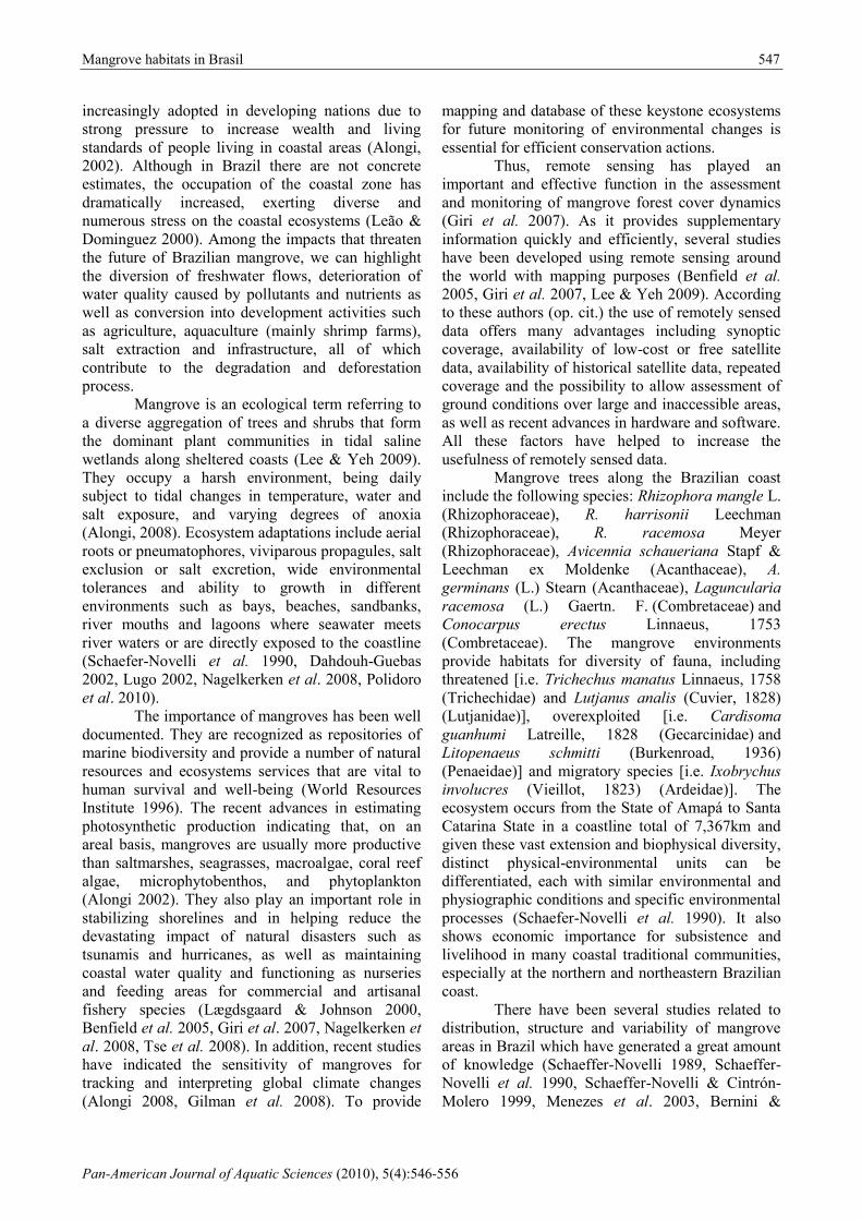
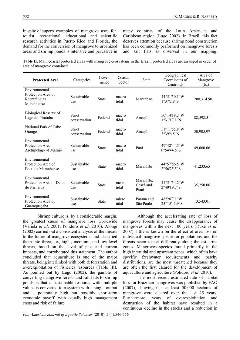
The coast of Brazil extends from tropical to
subtropical areas (4°N–34°S) and can be divided
into three sectors based on the tidal amplitude
(Figure 1) as described in Knoppers et al. (1999):
the macrotidal (tides higher than 4m) coast between
the Orange River mouth and the Parnaíba River
strandplain (4°N–3°S), the mesotidal (tidal
amplitude from 2m to 4m) coast between the
Parnaíba River mouth and south Bahia State (3–
15°S), and the microtidal (tides lower than 2m) coast
between south Bahia State and the Chuí (15–34°S).
In all sectors the tidal regime is semi-diurnal.
Although the most important mangrove forest in
terms of area occurs in macrotidal coast, other zones
in the mesotidal and the microtidal sectors are also
relevant because of the presence of other biophysical
mangrove units.
Figure 1. Map of the Brazil showing the macro, meso and microtidal coast.
To map the mangrove forest, Thematic
Mapper TM/LANDSAT-5 satellite images, with
pixel spacing of 30 m, were released by the Ministry
of Environment and were used in this study. The
images consisted of three (red), four (near-infrared),
and five (medium-infrared) channels that cover the
intervals 0.63-0.69 mm, 0.76-0.90 mm, and 1.55-
1.75 mm, respectively. The images were
geometrically rectified to the projection of
geographic coordinate system, spheroid SAD69 and
South America Datum 1969. To cover the entire
Brazilian coast 72 scenes collected from 2007 to
2009 were used to obtain at least one cloud-free
image of each area in the study region. Root mean
square (RMS) errors were less than 30 m in
agreement with mapping scale (1:100000). Band
Mangrove habitats in Brasil 549
Pan-American Journal of Aquatic Sciences (2010), 5(4):546-556
composites 543 were used for mangrove forest
detection through visual interpretation that was
based on the following elements: color, texture,
shape, size, context, geometry, and drainage system
configuration. The mosaic of images was processed
in ArcGIS 9.3, and two major classes were
delineated: mangrove and non-mangrove. Although
the salt flat constitutes the mangrove ecosystem, it
was not considered in the present analysis because
of doubts on the visual interpretation of this target.
The mangrove forest polygons generated were
quantified in terms of area and were analyzed as to
their overlap with the location of coastal protected
areas. The layers of protected areas were compiled
from the data set of the Chico Mendes Institute for
Biodiversity Conservation and the Brazilian Institute
of Environment and Renewable Natural Resources.
The mangrove forest polygons were validated with
basis in the literature, reports of researchers,
available aerial photographs, and personal
communications from staff of State Environmental
Agencies.
Results
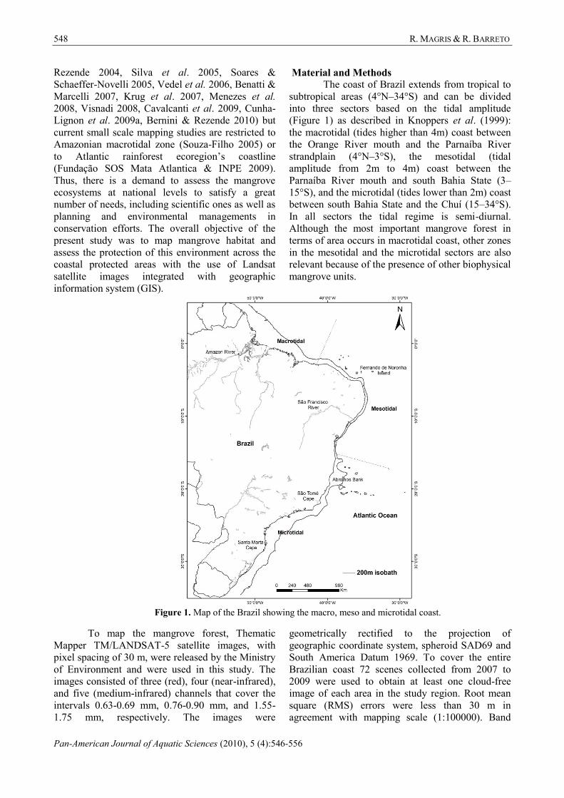
A total of 1,114,398.60 hectares of
mangrove habitat was registered as depicted in
Figure 2. If we considered the value obtained by
global-scale mapping reference in World Mangrove
Atlas (Spalding et al. 1997), the present result
indicates that Brazil’s mangrove correspond to
roughly 7.1% of these ecosystems throughout the
world. The macrotidal sector had 921,626.70
hectares that represented 83% of all mangrove forest
in Brazil. In contrast, meso and microtidal sectors
Figure 2. Brazilian mangrove forest extracted from satellite imagery.
had 117,709.63 and 75,062.27 hectares, respectively.
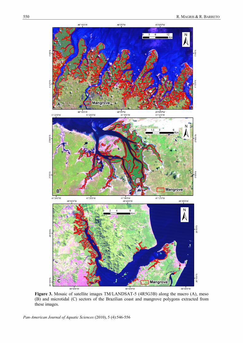
Figure 3 illustrates the mangrove map
extracted from mosaic images in three sites along
the Brazilian coast (macrotidal, mesotidal, and
microtidal sectors). Important continuous patches of
the mangrove habitat were mapped in Amapá State,
at the region between Pará and Maranhão States, and
at the region between São Paulo and Paraná State.
However, mangrove habitat showed high
fragmentation in the east coast. It was also possible
to identify extensive areas of shrimp farms in the
northeastern coast, which threaten mangrove
habitats.
Based upon the mapping of this study, mangrove
ecosystems have shown a high level of protection, with
more than 77% of the area of mangrove cover located
within protected areas if three levels of governance,
i.e., federal, state, and county, are considered. Table I
shows the area of protected mangrove in each sector of
coastal zone (macrotidal, mesotidal, and microtidal).
550 R. MAGRIS & R. BARRETO
Pan-American Journal of Aquatic Sciences (2010), 5 (4):546-556
Figure 3. Mosaic of satellite images TM/LANDSAT-5 (4R5G3B) along the macro (A), meso
(B) and microtidal (C) sectors of the Brazilian coast and mangrove polygons extracted from
these images.
Mangrove habitats in Brasil 551
Pan-American Journal of Aquatic Sciences (2010), 5(4):546-556
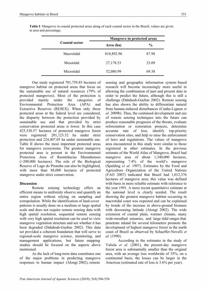
Table I: Mangrove in coastal protected areas along of each coastal sector in the Brazil; values are given
in area and percentage.
Coastal sector Mangrove in protected areas
Area (ha) %
Macrotidal 810,892.96 87.98
Mesotidal 27,178.53 23.09
Microtidal 52,080.99 69.38
Our study registered 701,759.85 hectares of
mangrove habitat on protected areas that focus on
the sustainable use of natural resources (79% of
protected mangroves). Most of the protection is
provided mainly under the categories of
Environmental Protection Area (APA) and
Extractive Reserves (RESEX). When only those
protected areas at the federal level are considered,
the disparity between the protection provided by
sustainable use and that provided by strict
conservation protected areas is lower. In this case
425,530.57 hectares of protected mangrove forest
were registered: 201,123.52 ha under strict
protection and 224,407.05 ha under sustainable use.
Table II shows the most important protected areas
for mangrove ecosystems. The greatest mangrove
protected area is present in the Environmental
Protection Area of Reentrâncias Maranhenses
(>200,000 hectares). The role of the Biological
Reserve of Lago do Piratuba can also be highlighted,
with more than 88,000 hectares of protected
mangrove under strict conservation.
Discussion
Remote sensing technology offers an
efficient means to uniformly observe and quantify an
entire region without relying on sampling and
extrapolation. While the identification of land-cover
patterns is usually done on a medium or large spatial
scale and does not require remote sensing data with
high spatial resolution, sequential remote sensing
with very high spatial resolution can be used to view
mangrove vegetation structure and see whether it has
been degraded (Dahdouh-Guebas 2002). This data
set provided a coherent foundation that will serve to
regional-scale mangrove science, monitoring, and
management applications, but future mapping
studies should be focused on the aspects above
mentioned.
As the lack of long-term data constitutes one
of the major problems in predicting mangrove
responses to human impact (Alongi 2002), remote
sensing and geographic information system–based
research will become increasingly more useful in
allowing the combination of past and present data in
order to predict the future, although this is still a
challenge (Dahdouh-Guebas 2002). Remote sensing
has also shown the ability to differentiate natural
from human-induced disturbances (Cunha-Lignon et
al. 2009b). Thus, the continued development and use
of remote sensing techniques into the future can
produce reasonable prognosis of the threats, evaluate
reforestation or restoration projects, determine
accurate rate of loss, identify top-priority
conservation sites, and help to raise the enforcement
of laws and regulations. The values of mangrove
area encountered in this study were similar to those
registered in other estimates. In the previous
estimate of the World Atlas of Mangrove, Brazil had
mangrove area of about 1,340,000 hectares,
representing 7.4% of the world’s mangrove
(Spalding et al. 1997). Estimates by the Food and
Agriculture Organization of the United Nations
(FAO 2007) indicated that Brazil had 1,012,376
hectares of mangrove area; this value was defined
with basis in more reliable estimate with reference to
the year 1991. A more recent quantitative estimate at
the national level is clearly needed. The result
showing the greatest mangrove habitat occurring in
macrotidal coast was expected and can be explained
by trends of the increase in above-ground biomass
with decreasing latitude (Alongi 2002). The wide
extension of coastal plain, warmer climate, many
wide-mouthed estuaries, and large tidal ranges that
penetrate inland for several kilometers promote the
development of highest mangrove forest in the north
coast of Brazil as observed by Schaeffer-Novelli et
al. (1990).
According to the estimates in the study of
Valiela et al. (2001), the present-day mangrove
forest area is substantially smaller than the original
area, with an average loss worldwide of 35%; on a
continental basis, the losses can be larger in the
Americas (estimated rate of loss is 3.6% per year).
552 R. MAGRIS & R. BARRETO
Pan-American Journal of Aquatic Sciences (2010), 5 (4):546-556
In spite of superb examples of mangrove uses for
tourist, recreational, educational and scientific
research activities in Puerto Rico and Florida, the
demand for the conversion of mangrove to urbanized
areas and shrimp ponds is intensive and pervasive in
many countries of the Latin American and
Caribbean region (Lugo 2002). In Brazil, this fact
deserves attention because shrimp pond construction
has been commonly performed on mangrove forests
and salt flats as observed in our mapping.
Table II: Main coastal protected areas with mangrove ecosystems in the Brazil; protected areas are arranged in order of
area of mangrove contained.
Protected Area Categories Gover-
nance
Coastal
Sector State
Geographical
Coordinates of
Centroids
Area of
Mangrove
(ha)
Environmental
Protection Area of
Reentrâncias
Maranhenses
Sustainable
use State
macro
tidal Maranhão
44°51'50.1"W
1°37'2.8"S 200,314.90
Biological Reserve of
Lago do Piratuba
Strict
conservation Federal
macro
tidal Amapá
50°14'19.2"W
1°31'17.1"N 88,598.51
National Park of Cabo
Orange
Strict
conservation Federal
macro
tidal Amapá
51°11'55.8"W
3°39'6.5"N 50,905.97
Environmental
Protection Area
Archipelago of Marajó
Sustainable
use State
macro
tidal Pará
49°42'44.5"W
0°54'44.5"S 49,060.06
Environmental
Protection Area of
Baixada Maranhense
Sustainable
use State
macro
tidal Maranhão
44°57'56.5"W
2°56'25.5"S 41,233.65
Environmental
Protection Area of Delta
do Parnaíba
Sustainable
use State
meso
tidal
Maranhão,
Ceará and
Piauí
41°51'54.2"W
2°49'19.7"S 35,250.06
Environmental
Protection Area of
Guaraqueçaba
Sustainable
use State
micro
tidal
Paraná and
São Paulo
48°26'7.1"W
25°15'45.9"S 13,543.01
Shrimp culture is, by a considerable margin,
the greatest cause of mangrove loss worldwide
(Valiela et al. 2001, Polidoro et al. 2010). Alongi
(2002) carried out a consistent analysis of the threats
to the future of mangrove ecosystems and classified
them into three, i.e., high-, medium-, and low-level
threats, based on the level of past and current
impacts, and corroborated this statement. The author
concluded that aquaculture is one of the major
threats, being interlinked with both deforestation and
overexploitation of fisheries resources (Table III).
As pointed out by Lugo (2002), the gamble of
converting mangrove forests and salt flats to shrimp
ponds is that a sustainable resource with multiple
values is converted to a system with a single output
and a potentially high but possibly short-term
economic payoff, with equally high management
costs and risk of failure.
Although the accelerating rate of loss of
mangrove forests may cause the disappearance of
mangroves within the next 100 years (Duke et al.
2007), little is known on the effect of area loss on
individual mangrove species or populations, and the
threats seem to act differently along the estuarine
zones. Mangroves species found primarily in the
high intertidal and upstream zones, which often have
specific freshwater requirements and patchy
distributions, are the most threatened because they
are often the first cleared for the development of
aquaculture and agriculture (Polidoro et al. 2010).
The most recent estimated rate of habitat
loss for Brazilian mangroves was published by FAO
(2007), showing that at least 50,000 hectares of
mangrove were cleared over the last 25 years.
Furthermore, years of overexploitation and
destruction of the habitat have resulted in a
continuous decline in the stocks and a reduction in
Mangrove habitats in Brasil 553
Pan-American Journal of Aquatic Sciences (2010), 5(4):546-556
the size of individuals of numerous crustaceans,
including blue land crab [Cardisoma guanhumi
Latreille, 1828 (Gecarcinidae)], swamp ghost crab
[Ucides cordatus (Linnaeus, 1763) (Ucididae)], and
blue crab [Callinectes sapidus Rathbun, 1896
(Portunidae)] (Wolff et al. 2000, Amaral &
Jablonski 2005). This has direct economic
consequences for human livelihoods that depend on
the fisheries. Besides the habitat loss, several studies
have also demonstrated that degraded ecosystems
have become common in mangrove areas situated in
the immediate vicinity of large cities (Harris &
Santos 2000, Silva et al. 2001, Machado et al. 2002,
Quevauviller et al. 2004, Hortellani et al. 2005).
Table III: Future threats to the world’s mangrove forests. Source: Alongi, 2002.
High-level threats Intermediate threats Low-level threats
Deforestation Alteration
of hydrology Oil pollution
Pond aquaculture Global warming Thermal pollution
Overexploitation of
fish and shellfish Eutrophication Tourism
Noise pollution
In Brazil, the Forest Code defines mangrove
habitats as Areas of Permanent Preservation (APP)
and provides restrictions on their uses. Total or
partial extraction of natural vegetation is permitted
only through the authorization of the relevant
government agencies and when it is of public and
social interest. Conversely, this legal instrument has
not been enough to ensure the protection needed.
One reason for this is that State Environmental
Agencies determine, for each case, the level of land
use restriction accepted. There is still no
comprehensive licensing system of activities
allowed in the mangrove areas and surroundings.
Moreover, a recent study undertaken in an area
under strong anthropogenic pressure (Guanabara
Bay, Brazil) confirmed worse conservation status of
the mangroves located outside the protected areas
(Cavalcanti et al. 2009). It evaluated the
effectiveness of the implementation of protected
areas for mangrove forests, and the results showed
significant differences regarding their main
structural parameters within and outside of protected
areas. Therefore, the role of protected areas is very
important both to preserve the mangrove forest
cover and to keep its structural and functional
characteristic.
According to the Law of National System of
Conservation Units, sanctioned in the year 2000,
protected areas are defined as territorial spaces that
together with their natural resources have been
legally recognized by the Public Authority and have
defined limits and conservation objectives and that
are brought under a management regime to ensure
adequate protection. These protected areas are
divided into two categories: strict protection and
sustainable use. The aim of protected areas of
sustainable use is to promote the use of the
ecosystem in ways that ensure the sustainability of
renewable natural resources and ecological
processes, whereas the strict protection areas allow
only indirect use of natural resources such as for
educational and scientific activities. Each category is
further subdivided into many management
categories with different ranks of protection. APAs,
in general, are large areas with specific purposes to
manage the process of human occupation, whereas
RESEXs are established through the traditional
population request with specific purpose to protect
the livelihoods and cultures of these populations and
their natural resources.
The high level of protection given to the
mangrove habitat under protected areas of
sustainable use should be viewed with caution in
terms of adequate conservation. A bottom-up
approach to participatory management is used in
these categories, with the community, the
government, and sector stakeholders working
closely to create consensus-building which will be
an important tool in threat mitigation. Some authors
have questioned whether this approach can ensure
the sustainable management of resources. As
described by Edgard et al. (2008), the identification
554 R. MAGRIS & R. BARRETO
Pan-American Journal of Aquatic Sciences (2010), 5 (4):546-556
of the sanctuary zones in the Galapagos Marine
Reserve through of a bottom-up and stakeholder-
driven process, following a series of face-to-face
meetings and involving sector representatives,
resulted in various biases such as having almost all
conservation zones located along coasts with little
fishery resources or with limited commercial diver
access. Furthermore, the adequate conservation of
the mangrove ecosystems must be attached by
maintaining several other adjacent ecosystems such
as sand dunes, sand bars, coral reefs, and mud flats,
considering the biogeochemical complex
interconnections among them.
Therefore, effective conservation needs to
be provided by a network of coastal and marine
protected areas to ensure the sustainable
management of mangrove resources. While most of
these areas are situated in the north coast, new
protected areas should be established in other eco-
regions, characterized by different morphologic
forms and with specific environmental processes,
such as in the northeastern and the eastern coasts.
Furthermore, focus on implementation efforts in
these areas should be attempted as a way of
maintaining the biodiversity levels and the full array
of services of this multifunctional ecosystem. Future
studies need to be directed to long-term monitoring
and mapping with higher-spatial-resolution images.
Acknowledgements
The authors wish to thank to several people
who contributed to this work in validation procedure
such as researchers, environmental analysts and
technical environment in State Environmental
Agencies. Also, we thank the Ministry of
Environment for the given support. We still
acknowledge the anonymous reviewers that
improved the paper.
References
Alongi, D. M. 2008. Mangrove forests: Resilience,
protection from tsunamis, and responses to
global climate change. Estuarine, Coastal
and Shelf Science, 76: 1-13.
Alongi, D. M. 2002. Present state and future of the
world’s mangrove forests. Environmental
Conservation, 29(3): 331-349.
Amaral, A. C. Z. & Jablonski, S. 2005. Conservation
of marine and coastal biodiversity in Brazil.
Conservation Biology, 19(3): 625-631.
Benatti, M. N. & Marcelli, M. P. 2007. Gêneros de
fungos liquenizados dos manguezais do Sul-
Sudeste do Brasil, com enfoque no manguezal
do Rio Itanhaém, Estado de São Paulo. Acta
Botanica Brasilica, 21(4): 863-878.
Benfield, S. L., Hector, M. G. & James, M. M. 2005.
Temporal mangrove dynamics in relation to
coastal development in Pacific Panama.
Journal of Environmental Management,
76: 263-276.
Bernini, E. & Rezende, C. E. 2004. Estrutura da
vegetação em florestas de mangue do estuário
do rio Paraíba do Sul, Estado do Rio de
Janeiro, Brasil. Acta Botanica Brasílica,
18(3): 491-502.
Bernini, E. & Rezende, C. E. 2010. Variação
estrutural em florestas de mangue do estuário
do rio Itabapoana, ES-RJ. Biotemas, 23(1):
49-60.
Cavalcanti, V. F., Soares, M. L. G., Estrada, G. C.
D. & Chaves, F. O. 2009. Evaluating
mangrove conservation through the analysis
of forest structure data. Journal of Coastal
Research, 56: 390-394.
Cunha-Lignon, M., Coelho-Jr., C., Almeida, R.,
Menghini, R., Correa, F., Schaeffer-Novelli,
Y., Cintrón-Molero, G. & Dahdouh-Guebas,
F. 2009a. Mangrove Forests and Sedimentary
Processes on the South Coast of São Paulo
State (Brazil). Journal of Coastal Research,
56: 405-409.
Cunha-Lignon, M., Menghini, R. P., Santos, L. C.
M., Niemeyer-Dinóla, C. & Schaeffer-
Novelli, Y. 2009b. Estudos de Caso nos
Manguezais do Estado de São Paulo (Brasil):
Aplicação de Ferramentas com Diferentes
Escalas Espaço-Temporais. Revista de
Gestão Costeira Integrada, 9(1): 79-91.
Dahdouh-Guebas, F. 2002. The use of remote
sensing and GIS in the sustainable
management of tropical coastal ecosystems.
Environment, Development and
Sustainability, 4: 93-112.
Defeo, O., McLachlan, A., Schoeman, D. S.,
Schlacher, T. A., Dugan, J., Jones, A., Lastra,
M. & Scarpini, F. 2009. Threats to sandy
beach ecosystems: A review. Estuarine,
Coastal and Shelf Science, 81: 1-12.
Duke, N. C., Meynecke, J. 0., Dittmann, A. M.,
Ellison, A. M., Aanger, K., Berger, U.,
Cannicci, S., Diele, K., Ewel, K. C., Field, C
.D., Koedam, N., Lee, S. Y., Marchand, C.,
Nordhaus, I. & Dahdouh-Guebas, F. 2007. A
world without mangroves? Science, 317: 41-
42.
Edgar, G. J., Langhammer, P. F., Allen, G., Brooks,
T. M., Brodie, J., Crosse, W., De Silva, N.,
Fishpool, L. D. C., Foster, M. N., Knox, D.
Mangrove habitats in Brasil 555
Pan-American Journal of Aquatic Sciences (2010), 5(4):546-556
H., Mccosker, J. E., Mcmanus, R., Millar, A.
J. K., Mugo, R. 2008. Key biodiversity areas
as globally significant target sites for the
conservation of marine biological diversity.
Aquatic Conservation: marine and
freshwater ecosystems, 18: 969-983.
Food and Agriculture Organization of the United
Nations - FAO. 2007. The world's
mangroves 1980-2005. FAO Forestry Paper
153, Rome, 77 p.
Fundação SOS Mata Atlântica & Instituto Nacional
de Pesquisas Epaciais. 2009. Atlas dos
remanescentes florestais da Mata
Atlântica: período 2005-2008. SOS Mata
Atlântica & INPE, São Paulo, 156 p.
Gilman, E. L., Ellison, J., Duke, N. C. & Field, C.
2008. Threats to mangroves from climate
change and adaptation options: A review.
Aquatic Botany, 89: 237-250.
Giri, C., Pengra, B., Zhu, Z., Singh, A. & Tieszen, L.
L. 2007. Monitoring mangrove forest
dynamics of the Sundarbans in Bangladesh
and India using multi-temporal satellite data
from 1973 to 2000. Estuarine, Coastal and
Shelf Science, 73: 91-100.
Harris, R. R. & Santos, M. C. F. 2000. Heavy metal
contamination and physiological variability in
the Brazilian mangrove crabs Ucides cordatus
and Callinectes danae (Crustacea: Decapoda).
Marine Biology, 137(4): 691-703.
Hortellani, M. A., Sarkis, J. E. S., Bonetti, J. &
Bonetti, C. 2005. Evaluation of mercury
contamination in sediments from Santos - São
Vicente Estuarine System, São Paulo State,
Brazil. Journal of the Brazilian Chemical
Society, 16(6a): 1140-1149.
Knoppers, B., Ekau, W. & Figueiredo, A. G. 1999.
The coast and shelf of east and northeast
Brazil and material transport. Geo-Marine
Letters, 19: 171-178.
Krug, L. A., Leão, C. & Amaral, S. 2007. Dinâmica
espaço-temporal de manguezais no Complexo
Estuarino de Paranaguá e relação entre
decréscimo de áreas de manguezal e dados
sócio-econômicos da região urbana do
município de Paranaguá – Paraná. XIII
Simpósio Brasileiro de Sensoriamento
Remoto, Florianópolis, Santa Catarina, Brasil,
2753-2760.
Laegdsgaard, P. & Johnson, C. 2000. Why do
juveniles fish utilize mangrove habitats?
Journal of Experimental Marine Biology
and Ecology, 257(2): 229-253.
Leão, Z. M. A. N. & Dominguez, J. M. L. 2000.
Tropical Coast of Brazil. Marine Pollution
Bulletin, 41(1-6): 112-122.
Lee, T-M. & Yeh, H-C. 2009. Applying remote
sensing techniques to monitor shifting
wetland vegetation: A case study of Danshui
River estuary mangrove communities,
Taiwan. Ecological Engineering, 35: 487-
496.
Lugo, A. 2002. Conserving Latin American and
Caribbean mangroves: issues and challenges.
Madera y Bosques Número especial, 8: 5-
25.
Machado, W., Moscatelli, M., Rezende. L. G &
Lacerda, L. D. 2002. Mercury, zinc, and
copper accumulation in mangrove sediments
surrounding a large landfill in southeast
Brazil. Environmental Pollution, 120(2):
455-461.
Menezes, M., Berger, U. & Worbes, M. 2003.
Annual growth rings and long-term growth
patterns of mangrove trees from the Bragança
peninsula, North Brazil. Wetlands Ecology
and Management, 11: 233-242.
Menezes, M. P. M., Berger, U. & Mehlig, U. 2008.
Mangrove vegetation in Amazonia: a review
of studies from the coast of Pará and
Maranhão States, North Brazil. Acta
Amazonica, 38(3): 403-420.
Nagelkerken, I., Blaber, S. J. M., Bouillon, S.,
Green, P., Haywood, M., Kirton, L. G.,
Meynecke, J-O., Pawlik, J., Penrose, H. M.,
Sasekumar, A. & Somerfield, P. J. 2008. The
habitat function of mangroves for terrestrial
and marine fauna: A review. Aquatic Botany,
89: 155-185.
Ong, J. E. 1995. The ecology of mangrove
conservation and management.
Hydrobiologia, 51: 295-343.
Polidoro, B. A., Carpenter, K. E., Collins, L., Duke,
N. C., Ellison, A. M., Ellison, J. C.,
Farnsworth, E. J., Fernando, E. S., Kathiresan,
K., Koedam, N. E., Livingstone, S. R.,
Miyagi, T., Moore, G. E., Nam, V. N., Ong, J.
E., Primavera, J. H., Salmo III, S. G.,
Sanciangco, J. C., Sukardjo, S., Wang, Y. &
Yong, J. W. H. 2010. The loss of species:
mangrove extinction risk and geographic
areas of global concern. PLoSONE, 5(4): 1-
10.
Quevauviller, P., Donard, O. F. X, Wasserman, J. C.,
Martin, F. M. & Schneider, J. 2004.
Occurrence of methylated tin and dimethyl
mercury compounds in a mangrove core from
556 R. MAGRIS & R. BARRETO
Pan-American Journal of Aquatic Sciences (2010), 5 (4):546-556
Sepetiba Bay, Brazil. Applied
Organometallic Chemistry, 6(2): 221-228.
Schaeffer-Novelli, Y. 1989. Perfil dos Ecossistemas
litorâneas brasileiros, com especial
ênfasesobre o ecossistema manguezal. Pub.
Esp. do Instituto Oceanográfico, 7: 1-16.
Schaeffer-Novelli, Y. & Cintrón-Molero, G. 1999.
Brazilian mangroves: a historical ecology.
Jornal Ciência e Cultura 51: 274-286.
Schaeffer-Novelli, Y., Cintrón-Molero, G. &
Adaima, R. R. 1990. Variability of mangrove
ecosystems along the Brazilian coast.
Estuaries 13: 204-218.
Silva, C. A. R, Rainbow, P. S., Smith, B. D. &
Santos, Z. L. 2001. Biomonitoring of trace
metal contamination in the Potengi estuary,
Natal (Brazil), using the oyster Crassostrea
rhizophorae, a local food source. Water
Research, 35(17): 4072-4078.
Silva, M. A. B., Bernini, E. & Carmo, T. M. S. 2005.
Características estruturais de bosques de
mangue do estuário do rio São Mateus, ES,
Brasil. Acta Botanica Brasilica, 19(3): 465-
471.
Soares, M. L. G. & Schaeffer-Novelli, Y. 2005.
Above-groud biomass of mangrove species. I.
Analysis of models. Estuarine, Coastal and
Shelf Science, 65: 1-18.
Souza-Filho, P. W. M. 2005. Costa de Manguezais
de Macromaré na Amazônia: Cenários
Morfológicos, Mapeamento e Quantificação
de Áreas Usando Dados de Sensores
Remotos. Revista Brasileira de Geofísica,
23(4): 427-435.
Spalding, M., Blasco, F. & Field, C. 1997. World
Mangrove Atlas. ISME, Okinawa, 178 p.
Tse, P., Nip, T. H. M. & Wong, C. K. 2008. Nursery
function of mangrove: A comparison with
mudflat in terms of fish species composition
and fish diet. Estuarine, Coastal and Shelf
Science, 80: 235-242.
Valiela I., Bowen J. L. & York, J.K. 2001.
Mangrove forests: one of the world’s
threatened major tropical environments.
BioScience 51(10): 807-815.
Vedel, V., Behling, H., Cohen, M. & Lara, B. 2006.
Holocene mangrove dynamics and sea-level
changes in northern Brazil, inferences from
the Taperebal core in northeastern Pará State.
Vegetation History and Archaebotany, 15:
115-123.
Visnadi, S. R. 2008. Marchantiophyta e Bryophyta
de manguezais do estado de São Paulo, Brasil.
Boletim do Museu Paraense Emílio Goeldi,
3(1): 69-80.
Wolff, M., Koch, V. & Isaac, V. 2000. A trophic
flow model of the Caeté Mangrove Estuary
(North Brazil) with considerations for the
sustainable use of its resources. Estuarine,
Coastal and Shelf Science, 50(6): 789-803.
World Resources Institute. 1996. World Resources
1996-1997. Oxford University Press, Oxford,
365 p.
Received April 2010
Accepted August 2010
Published online August 2011