Embed Size (px)
Citation preview
1

2
Earth is a round, maps are not.
Four projection families.
Equivalent (Equal Area) projections
Preserves relative areasCommonly used for thematic mapsEx: Albers
Conformal projectionsPreserve angles, correct shape… with small shapes at leastGraticule has right anglesEx. Mercator
EquidistantPreserves distance, equal scale along standard parallel(s), latitude of origin
* No flat map is both equivalent and conformal – only globes have this property
Map Projections (Part 1)
planarconical
(not comical)cylindrical
Three classes (families) of projections:
Developable surface as a:
• Planar (Azimuthal), project the globe onto a tangent plane.
• Conic, project the globe on to a cone
• Cylindrical, central cylindrical vs. cylindrical equal-area
Perspective (“point of projection”)
Orthographic- light source at infinity (straight through)
Stereographic- light source at opposite side of the sphere
Gnomonic- centrally located light source- preserves great circles as straight lines- distortions increase from standard point or line, increase outward in concentric bands
Stereographic
OrthographicGnomonic
The transformation process simplified: a light source is in center of the cut out globe casts shadows from the continents of the model of the Earth onto on a plane that is tangent to it, tracing the outline leaves projected coordinate system.
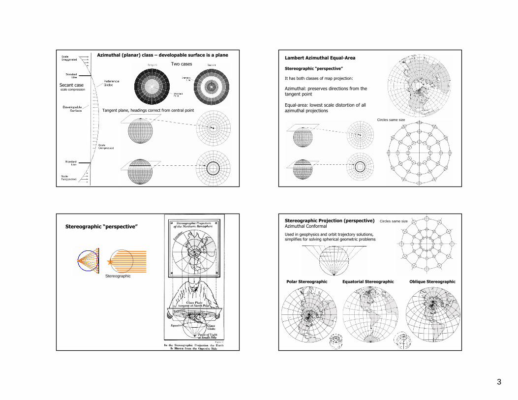
3
Tangent plane, headings correct from central point
Secant casescale compression
Two cases
Azimuthal (planar) class – developable surface is a planeLambert Azimuthal Equal-Area
Stereographic “perspective”
It has both classes of map projection:
Azimuthal: preserves directions from the tangent point
Equal-area: lowest scale distortion of all azimuthal projections
Circles same size
Stereographic “perspective”
StereographicPolar Stereographic Equatorial Stereographic Oblique Stereographic
Stereographic Projection (perspective)Azimuthal Conformal
Used in geophysics and orbit trajectory solutions, simplifies for solving spherical geometric problems
Circles same size

4
Orthographic Projection (perspective)
Azimuthal non-Conformal
Popular visualization, the “earth from space” perspective view
Distortion is extreme
Circles different size
Oblique OrthographicEquatorial Orthographic Polar Orthographic
Mercator Projectionvs.
Oblique Orthographic
Right, Caption read something like:
“The Senator is using tax payers dollars to make an out of the way illegal campaign stop to Anchorage”
Dashed = rhumb line (constant heading)Solid = great circle route
Oblique GnomonicEquatorial Gnomonic Polar Gnomonic
Gnomonic Projection (perspective)
Distorts everything – but straight lines are great circles
Useful for finding the shortest path distance between two locations, but limited because < ½ hemisphere is visible
A line that crosses all meridians at the same angle is called a rhumb line, loxodrome, (or azimuth)
Gnomic projections are in the planar family, used in aviation because great circles are straight lines
Mercator
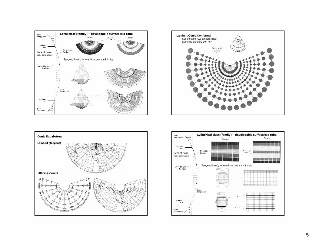
5
Tangent line(s), where distortion is minimized
Secant casescale compression
Conic class (family) – developable surface is a coneLambert Conic Conformal
Secant case (two tangent lines)Standard parallels 30n 45n
Conic Equal-Area
Lambert (tangent)
Albers (secant)
Tangent line(s), where distortion is minimized
Secant casescale compression
Cylindrical class (family) – developable surface is a tube
6
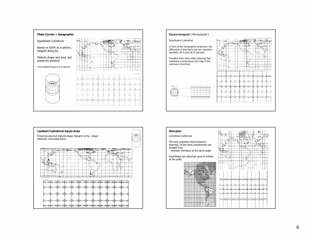
Plate Carree = Geographic
Equidistant Cylindrical
Based on Earth as a sphere, tangent along Eq.
Distorts shape and area, but preserves distance
*non-existent Figure 8.5 in Slocum
Equirectangular (“Rectangular”)
Equidistant Cylindrical
A form of the Geographic projection; the difference is that there are two standard parallels, 30 N and 30 S (secant)
Parallels lines have wider spacing than meridians (compresses the map in the east-west direction)
30 degree graticule
Lambert Cylindrical Equal-Area
Preserves area but distorts shape (tangent at Eq., shape distortion minimized there)
Mercator
Cylindrical Conformal
The only projection that preserves bearings, rhumb lines (loxodromes) are straight lines- intersect meridians at the same angle
Area/Shape are distorted, goes to infinity at the poles
7
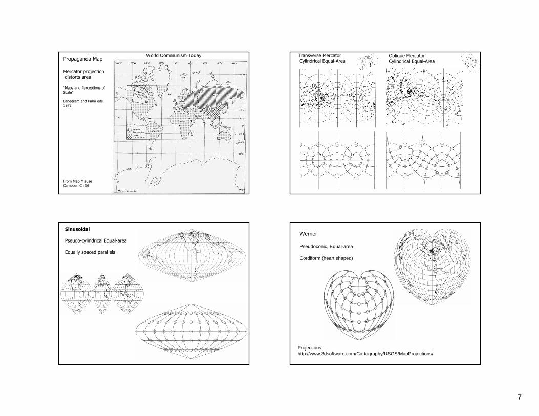
Propaganda Map
Mercator projection distorts area
“Maps and Perceptions of Scale”
Lanegram and Palm eds. 1973
From Map MisuseCampbell Ch 16
World Communism Today Oblique MercatorCylindrical Equal-Area
Transverse MercatorCylindrical Equal-Area
Sinusoidal
Pseudo-cylindrical Equal-area
Equally spaced parallels
Werner
Pseudoconic, Equal-area
Cordiform (heart shaped)
Projections:http://www.3dsoftware.com/Cartography/USGS/MapProjections/
8
not equivalentequivalent
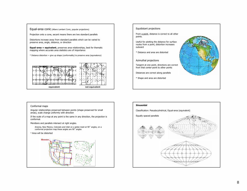
Equal-area conic (Albers Lambert Conic, popular projections)
Projection onto a cone, secant means there are two standard parallels
Distortions increase away from standard parallels which can be varied to preserve area, angle, distance, or direction
Equal-area = equivalent, preserves area relationships, best for thematic mapping where accurate area statistics are of importance
* Distance distortion = give up shape (conformality) to preserve area (equivalence)
Equidistant projections
From a point, distance is correct to all other points.
Useful for plotting the distance for surface routes from a point, distortion increases outward
* Distance and area are distorted
Azimuthal projections
Tangent at one point, directions are correct from that center-point to other points
Distances are correct along parallels
* Shape and area are distorted
Conformal maps
Angular relationships preserved between points (shape preserved for small areas), scale change uniformly with direction
If the scale of a map at any point is the same in any direction, the projection is conformal.
Meridians and parallels intersect at right angles.
Arizona, New Mexico, Colorado and Utah on a globe meet at 90˚ angles, on a conformal projection map these angles are 90˚ angles
* Area will be distorted
Sinusoidal
Classification: Pseudocylindrical, Equal-area (equivalent)
Equally spaced parallels
9
All projections distort
Preserving area: equivalent, preserving angles/shape: conformal
* cannot preserve both area & shape
Preserving distance: equidistant
* cannot preserve area & distance
Preserving direction: azimuthal (plane)
* can preserve direction and area, OR shape, OR distance
Compromise projection don’t preserve area, shape, distance, or direction but minimize distortion overall (good for world maps for general use)
Robinson, Miller, Gall-Peters etc.
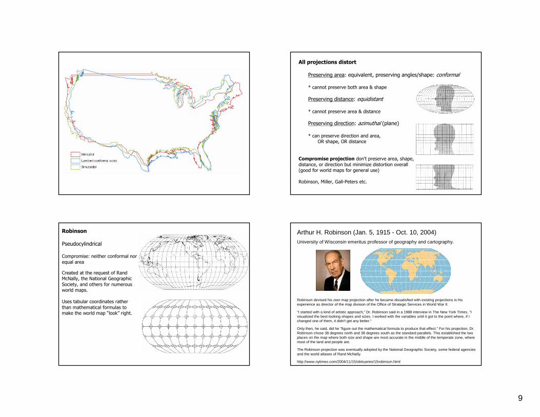
Robinson
Pseudocylindrical
Compromise: neither conformal nor equal area
Created at the request of Rand McNally, the National Geographic Society, and others for numerous world maps.
Uses tabular coordinates rather than mathematical formulas to make the world map “look” right.
Arthur H. Robinson (Jan. 5, 1915 - Oct. 10, 2004)University of Wisconsin emeritus professor of geography and cartography.
Robinson devised his own map projection after he became dissatisfied with existing projections is his experience as director of the map division of the Office of Strategic Services in World War II.
"I started with a kind of artistic approach," Dr. Robinson said in a 1988 interview in The New York Times. "I visualized the best-looking shapes and sizes. I worked with the variables until it got to the point where, if I changed one of them, it didn't get any better.“
Only then, he said, did he "figure out the mathematical formula to produce that effect." For his projection, Dr. Robinson chose 38 degrees north and 38 degrees south as the standard parallels. This established the two places on the map where both size and shape are most accurate in the middle of the temperate zone, where most of the land and people are.
The Robinson projection was eventually adopted by the National Geographic Society, some federal agencies and the world atlases of Rand McNally.
http://www.nytimes.com/2004/11/15/obituaries/15robinson.html
10
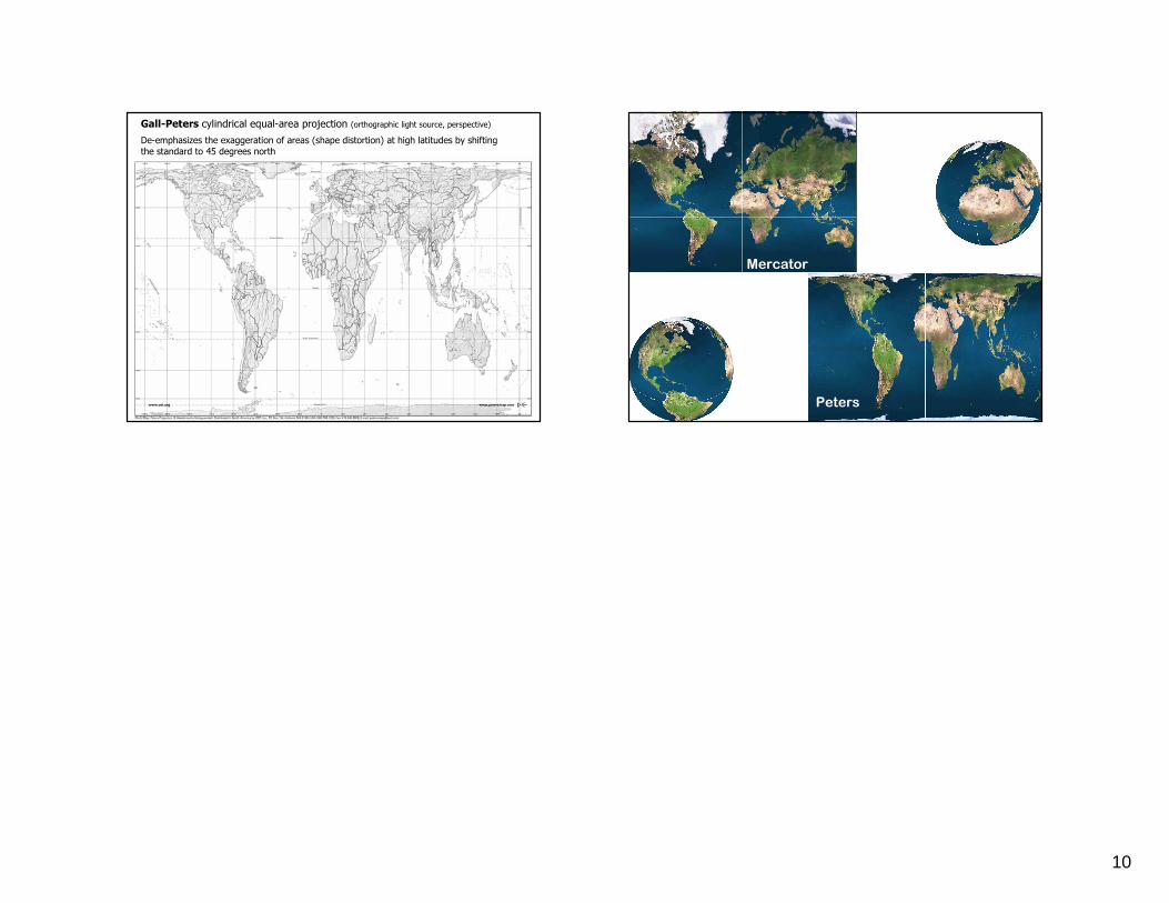
Gall-Peters cylindrical equal-area projection (orthographic light source, perspective)
De-emphasizes the exaggeration of areas (shape distortion) at high latitudes by shifting the standard to 45 degrees north
Mercator
Peters