Embed Size (px)
Citation preview
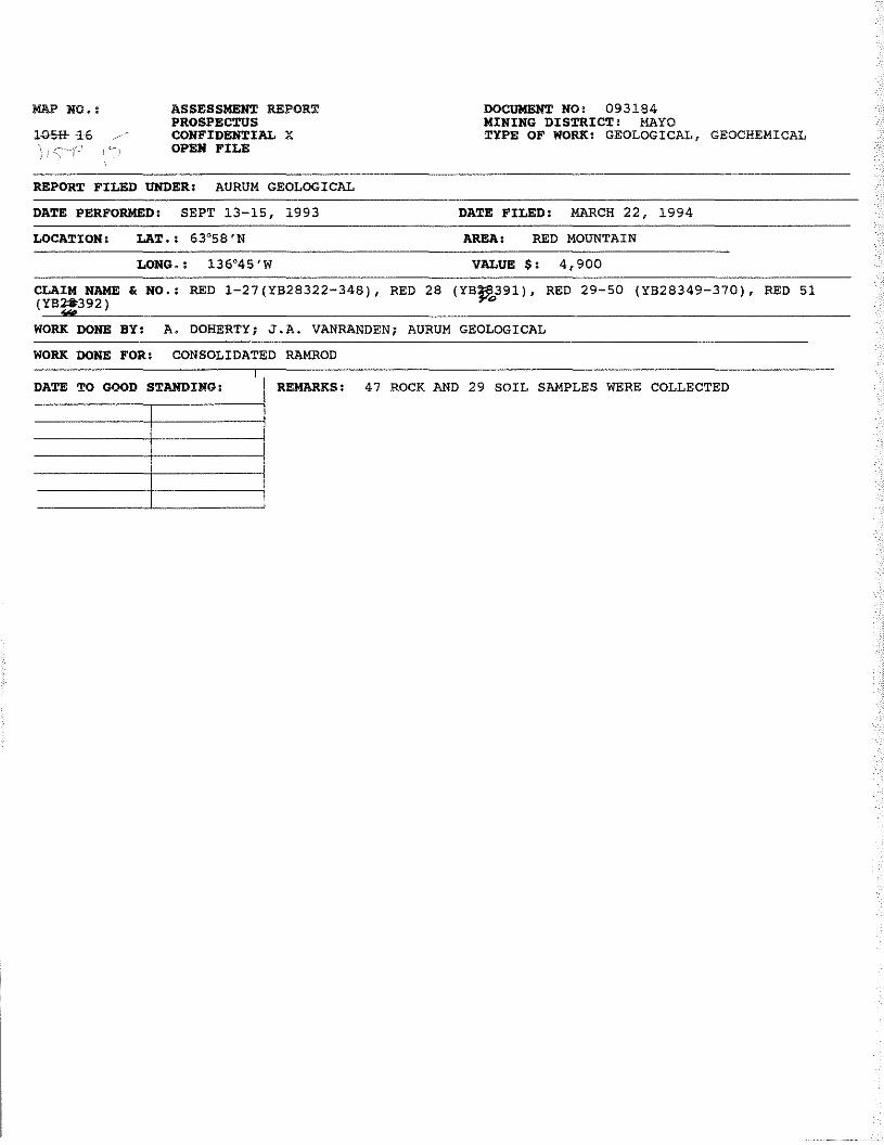
ASSESSMENT REPORTPROSPECTUSCONFIDENTIAL XOPEN FILE
DOCUMENTNO: 093184MINING DISTRICT: MAYOTYPE OF WORK: GEOLOGICAL, GEOCHEMICAL
MAP NO.:
1081+16 ~-
REPORT FILED UNDER: AURUM GEOLOGICAL
DATE PERFORMED: SEPT 13—15, 1993 DATE FILED: MARCH 22, 1994
LOCATION: LAT.: 63°58’N AREA: RED MOUNTAIN
LONG,: 136°45’W vALUE $: 4,900
CLAIM NAME & NO.:(Y82S392)
‘S
RED 1—27(Y828322—348), RED 28 (YB~391),°
RED 29—SO (YB28349—370), RED 51
WORK DONE BY: A, DOHERTY; J.A. VANRANDEN; AURUM GEOLOGICAL
WORK DONE FOR: CONSOLIDATED RAMROD
DATE TO GOOD STANDING: REMARKS: 47 ROCKAND 29 SOIL SAMPLES WERE COLLECTED
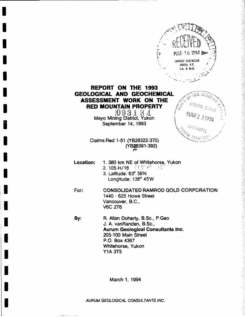
REPORT ON THE 1993GEOLOGICAL AND GEOCHEMICAL
ASSESSMENT WORK ON THERED MOUNTAIN PROPERTY
(093184Mayo Mining District, Yukon
September14, 1993
Claims:Red1-51 (YB28322-370)(YB28391-392)
*10
Location: 1. 380 km NE of Whitehorse Yukon2.i05-H-/16 /IYP° (~3, Latitude: 63°58’N
Longitude: 136°45W
For: CONSOLIDATED RAMROD GOLD CORPORATION1440 - 625 Howe StreetVancouver, B.C.,V6C 2T6
By: A. Allan Doherty, B.Sc., P.GeoJ. A. vanRanden, B.Sc.,Aurum Geological Consultants Inc.205-100 Main StreetP.O. Box 4367Whitehorse, YukonY1A 3T5
March 1, 1994
£I
I
MAR 161994MUWUI nazmEa
SIB. Ti.L& & fl
AURUM GEOLOGICAL CONSULTANTS INC.
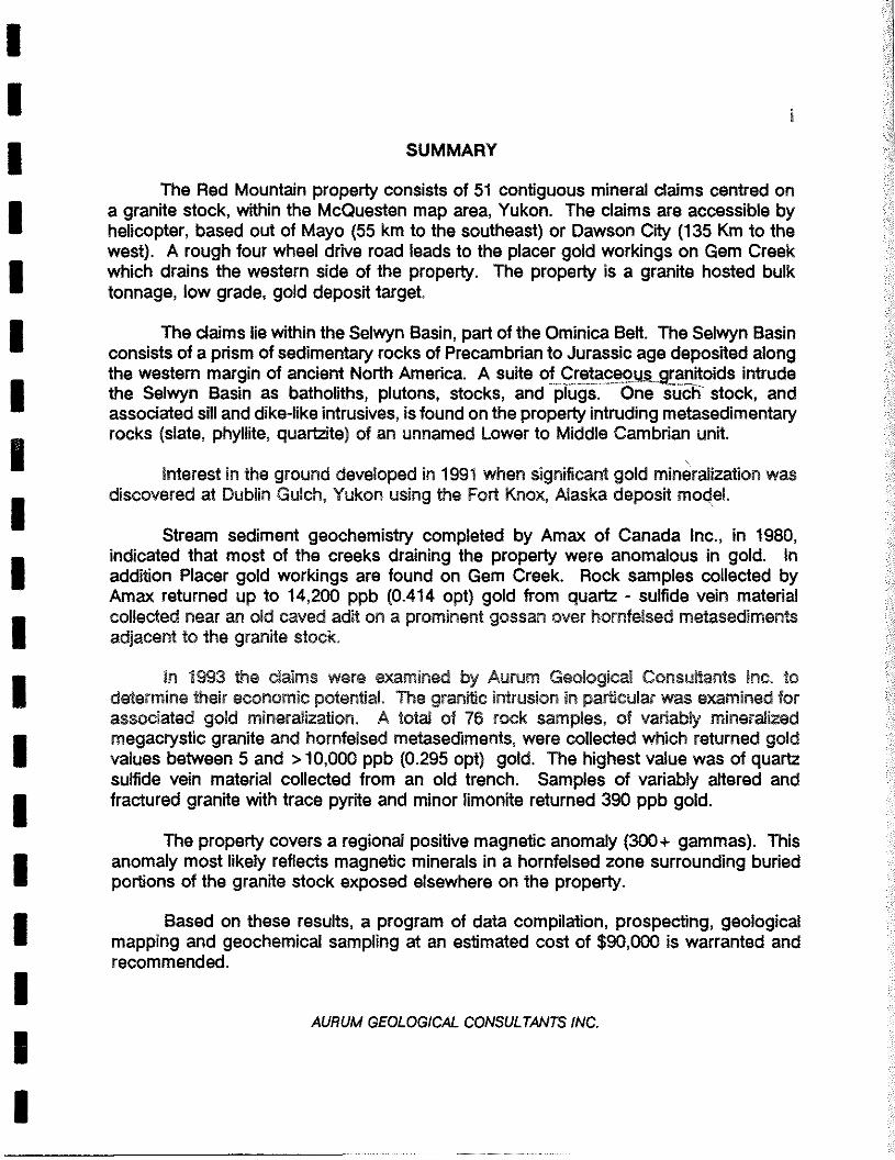
SUMMARY
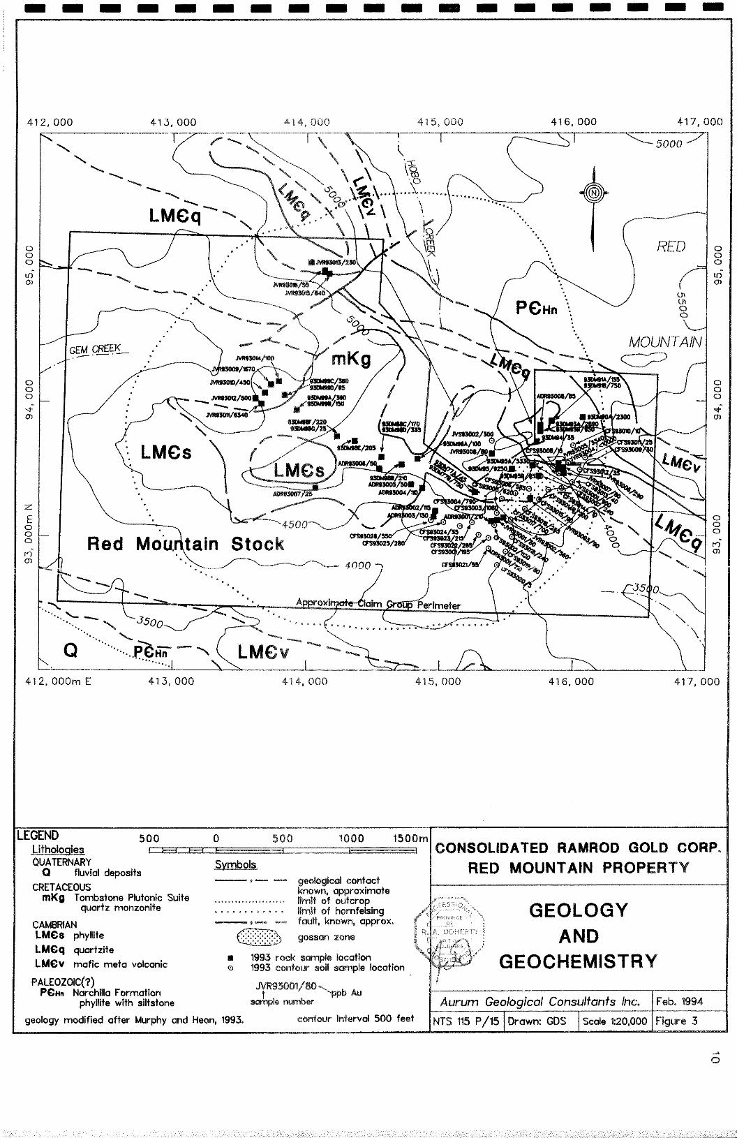
The Red Mountain property consists of 51 contiguous mineral claims centred ona granite stock, within the McQuesten map area, Yukon The clams are accessible byhelicopter, based out of Mayo (55 km to the southeast) or Dawson City (135 Km to thewest) A rough four wheel drive road leads to the placer gold workings on Gem Creekwhich drains the western side of the property The property is a granite hosted bulktonnage, low grade, gold deposit target
The claims lie within the Selwyn Basin, part of the Ominica Belt The Selwyn Basinconsists of a prism of sedimentary rocks of Precambnan to Jurassic age deposited alongthe western margin of ancient North Amenca A suite of C ~ceo ranitoids intrudethe Selwyn Basin as bathoriths, plutons, stocks, and plugs One such stock, andassociated sill and dike-like intrusives, is found on the property intruding metasedimentaryrocks (slate, phyllite, quartzite) of an unnamed Lower to Middle Cambnan unit
Interest in the ground developed in 1991 when significant gold mineralization wasdiscovered at Dublin Gulch, Yukon using the Fort Knox, Alaska deposit moqel
Stream sediment geochemistry completed by Amax of Canada Inc, in 1980,indicated that most of the creeks draining the property were anomalous in gold Inaddition Placer gold workings are found on Gem Creek Rock samples collected byAmax returned up to 14,200 ppb (0414 opt) gold from quartz - sulfide vein materialcollected near an old caved adit on a prominent gossan over hornfelsed metasedimentsadjacent to the granite stock
In 1993 the clams were examined by Aurum Geological Consultants Inc todetermine their economic potential The granite intrusion in particular was examined forassociated gold mineralization A total of 76 rock samples, of variably minerahzedmegacrystic granite and hornfelsed metasediments, were collected which returned goldvalues between 5 and >10,000 ppb (0 295 opt) gold The highest value was of quartzsulfide vein material collected from an old trench Samples of vanably altered andfractured granite with trace pyrite and minor limonite returned 390 ppb gold
The property covers a regional positive magnetic anomaly (300÷gammas) Thisanomaly most likely reflects magnetic minerals in a hornfelsed zone surrounding buriedportions of the granite stock exposed elsewhere on the property
Based on these results, a program of data compilation, prospecting, geologicalmapping and geochemical sampling at an estimated cost of $90,000 is warranted andrecommended.
AURUM GEOLOGICAL CONSULTANTS INC.

ii
TABLE OF CONTENTSPage
SUMMARYTABLE OF CONTENTS iiINTRODUCTION 1LOCATION AND ACCESS 1PHYSIOGRAPHY, CLIMATE AND VEGETATION 3PROPERTY 4HISTORY 6GEOLOGY 7
Regional Geology 7Property Geology 8
MINERALIZATION 9Regional Metallogeny 9Property Mineralization 9
GEOCHEMISTRY 121993 Results 12
GEOPHYSICS 12CONCLUSIONS AND RECOMMENDATIONS 13REFERENCES 15STATEMENT OF QUALIFICATIONS (RAD) 17STATEMENT OF QUALIFICATIONS (JvR) 18STATEMENT OF COSTS 19
LIST OF FIGURES
Figure 1: Location Map; 1:1,000,000 2Figure 2: Claim Map; 1:31,680 5Figure 3: Geology & Geochemistry Map; 1:25,000 10
LIST OF TABLES
Table 1: Red Mountain Claim Data 4
LIST OF APPENDICES
Appendix A - Analytical Methods and Reports-
Appendix B - Rock Sample Descriptions
AL/RUM GEOLOGICAL CONSULTANTS INC.
1
INTRODUCTION
This report was prepared at the request of the directors of Consolidated RamrodGold Corporation, owner of the Red claims, herein after called the Red Mountain property.Its purpose is to assess the property’s economic potential and to satisfy assessmentrequirements through a description of exploration work carried out in 1993.
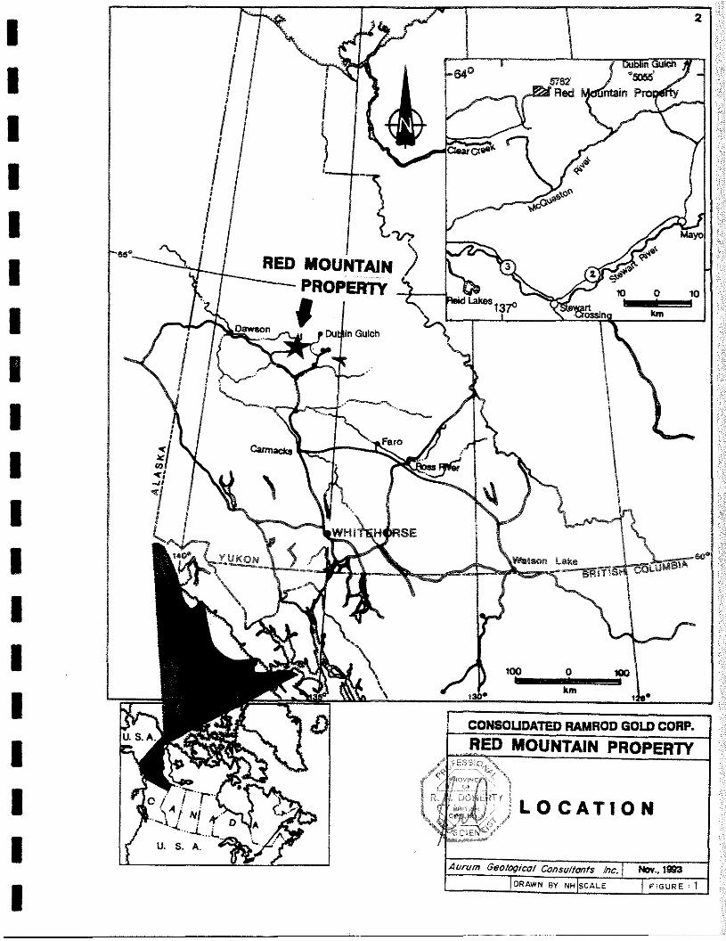
The property is located approximately 135 kilometres east of Dawson City, Yukon(Figure 1) on the boundary of the Mayo and Dawson Mining Districts, and is accessibleby hericopter.
Exploration work carried out in 1993 consisted of geological mapping andgeochemical sampling and prospecting for the purpose of locating gold deposits. Thiswork was carried out on September 14, 1993 by; Al Doherty, P.Geo., Jo-AnnevanRanden, B.Sc., and Conrad Fox of Aurum Geological Consultants Inc. Regionalmapping (at a scale of 1:50 000) was conducted over the Red Mountain property by theCanada/Yukon Geoscience Office (Murphy and Heon, 1994). Previous work issummarized from an assessment report by Doherty and Huistein (1992), Kidlark (1980),a summary geological report by Crysi Exploration (1992), and published reports andmaps.
LOCATION AND ACCESS
The dais are located 135 km east of Dawson City, Yukon (Figure 1). The claimsare c~ntredàta~proximately63°58’ N latitude and 136°45 W longitude within NTS maparea1 1 15
Access to the property in September 1993 was by helicopter based in Mayo 55 kmto the southeast. Alternatively, helicopters are available in Dawson City. The Clear CreekRoad coming in from the Klondike highway (#2) provides road access to the area anda rough four wheel drive road leads to the placer workings on Gem Creek which drainsthe western side of the property. The Clear Creek Road is not maintained and is usableonly during the summer months.
AURUM GEOLOGICAL CONSULTANTS INC.
J~~VNBY NH~SCALE J FW%JRE 1Aw-uni Geologico, Consultants Inc. I Nov., 1~3
3
PHYSIOGRAPHY, CLIMATE AND VEGETATION
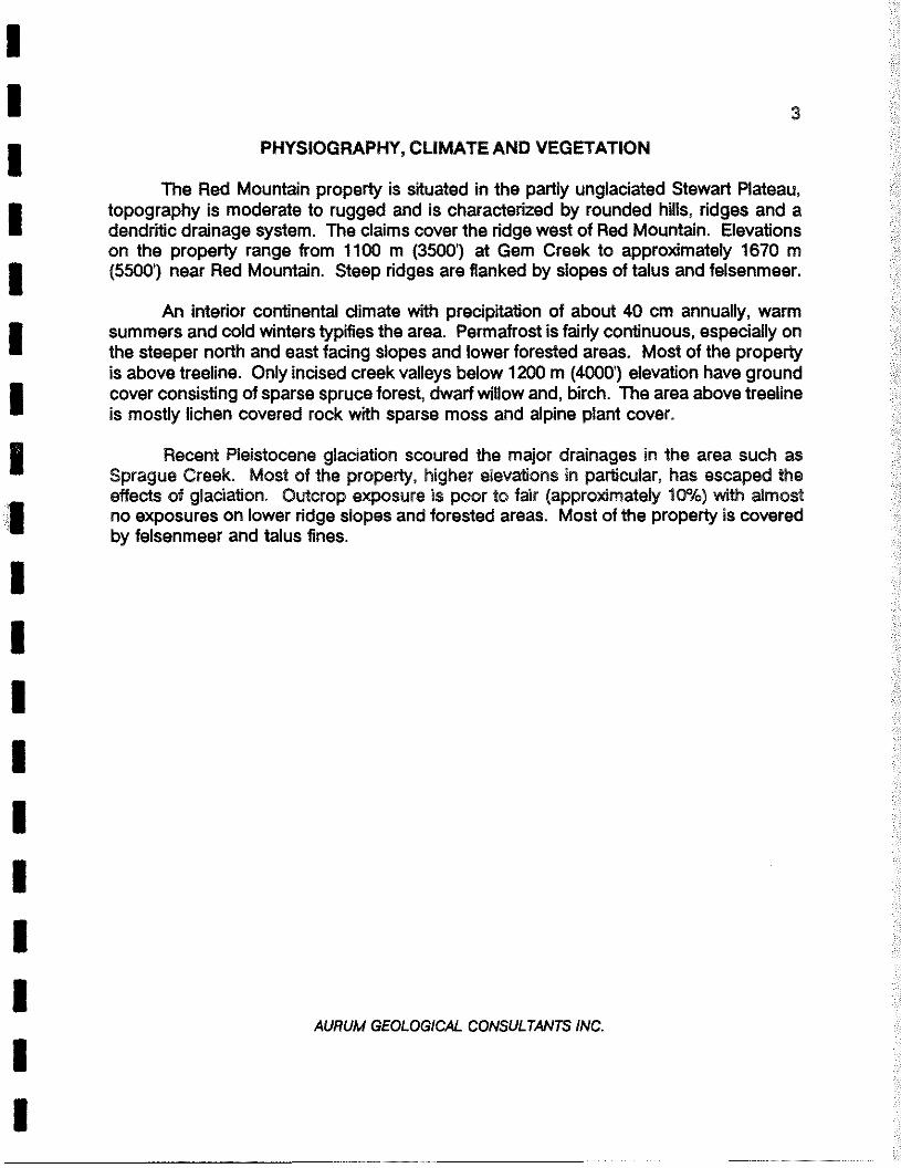
The Red Mountain property is situated in the partly unglaciated Stewart Plateau,topography is moderate to rugged and is characterized by rounded hills, ridges and adendritic drainage system. The claims cover the ridge west of Red Mountain. Elevationson the property range from 1100 m (3500’) at Gem Creek to approximately 1670 m(5500’) near Red Mountain. Steep ridges are flanked by slopes of talus and felsenmeer.
An interior continental climate with precipitation of about 40 cm annually, warmsummers and cold winters typifies the area. Permafrost is fairly continuous, especially onthe steeper north and east facing slopes and lower forested areas. Most of the propertyis above treeline. Only incised creek valleys below 1200 m (4000’) elevation have groundcover consisting of sparse spruce forest, dwarf willow and, birch. The area above treelineis mostly lichen covered rock with sparse moss and alpine plant cover.
Recent Pleistocene glaciation scoured the major drainages in the area such asSprague Creek. Most of the property, higher elevations in particular, has escaped theeffects of glaciation. Outcrop exposure is poor to fair (approximately 10%) with almostno exposures on lower ridge slopes and forested areas. Most of the property is coveredby felsenmeer and talus fines.
AURUM GEOLOGICAL CONSULTANTS INC.
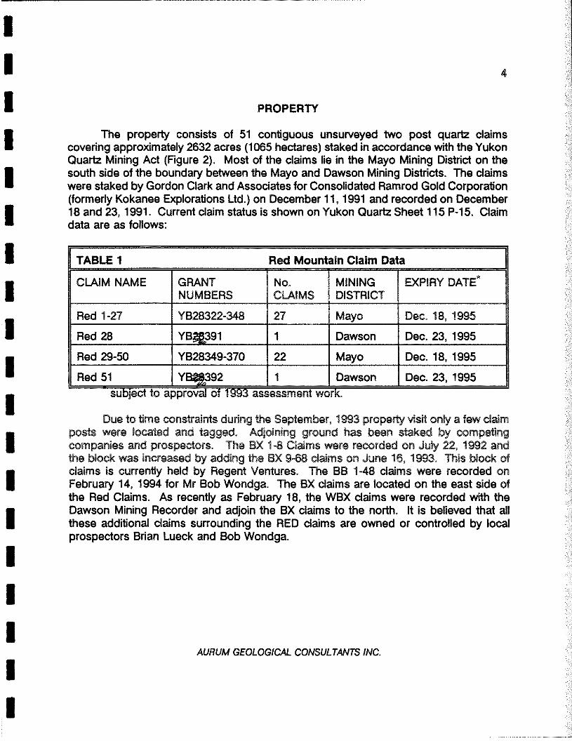
PROPERTY
The property consists of 51 contiguous unsurveyed two post quartz claimscovering approximately 2632 acres (1065 hectares) staked in accordance with the YukonQuartz Mining Act (Figure 2). Most of the claims lie in the Mayo Mining District on thesouth side of the boundary between the Mayo and Dawson Mining Districts. The claimswere staked byGordon Clark and Associates for Consolidated Ramrod Gold Corporation(formerly Kokanee Explorations Ltd.) on December 11, 1991 and recorded on December18 and 23, 1991. Current claim status is shown on Yukon Quartz Sheet 115 P-iS. Claimdata are as follows:
TABLE 1 Red Mountain Claim Data
CLAIM NAME GRANTNUMBERS
No.CLAIMS
MININGDISTRICT
EXPIRY DATE*
Red 1-27 YB28322-348 27 Mayo Dec. 18, 1995
Red 28 YB~391 1 Dawson Dec. 23, 1995
Red 29-50 YB28349-370 22 Mayo Dec. 18, 1995
Red 51 Y~392 1 Dawson Dec. 23, 1995subject to approval of 1993 assessment work.
Due to time constraints during the September, 1993 property visit only a few claimposts were located and tagged. Adjoining ground has been staked by competingcompanies and prospectors. The BX 1-8 Claims were recorded on July 22, 1992 andthe block was increased by adding the BX 9-68 claims on June 16, 1993. This block ofclaims is currently held by Regent Ventures. The BB 1-48 claims were recorded onFebruary 14, 1994 for Mr Bob Wondga. The BX claims are located on the east side ofthe Red Claims. As recently as February 18, the WBX claims were recorded with theDawson Mining Recorder and adjoin the BX claims to the north. It is believed that allthese additional claims surrounding the RED claims are owned or controlled by localprospectors Brian Lueck and Bob Wondga.
AL/RUM GEOLOGICAL CONSULTANTS INC.
4
Jnfl)1J~
-1~~~
-Ir4
i~: 5-~
136°CLx~iN~1425, 42 12 ~~ Y842t4~~ ~ 14~~ _
( B YB4fl.±LJ~T~74842) .8’~4fl~4 4 163
‘I17 1842371i~BX raiBX -i----
~fr441B42i~~\.~‘ Y842J~ YeA)165 491 20 4t~231342 41 ~_~•214J T~~’ztisIy~~~42
MIn%n9~OIStflCt - 1va42l7-.t--
I YB4?37S 18t23308 -~~ I YBs2~jB_____ _____ ______ t YB423~~4~Ir
~“ 18 .4jnnso I r&274, ~~ Wi ._fI~7Y842U2yB~j_jTh~rB253fl YB2$366___ ~6‘9
Th21367 Y94 ______
~—r~ ~r828360 .f~s2a3sL~~—ts2Ps6 ______ ______
________ ________ 2fl46I YB2,~359 Yt 1 YB21355 ~ 6 YBTh3~2 45Q~
__ -
~2I3~% N ‘, ______ ______ YS2
B32
7j”~126323
I
r& 1321 f (B”25 ~B2B32& fYS2~V~133
I km
I km pLEGEND
ft f._c~aim boundaryclaim number
tag numberstaking direction
creek R;i
elevation contour; interval 500 ft.
‘ 4WD trail
NoteS conrec from 0. A N 0. mop sheet 115P/15
KILOMETRE
CONSOLIDATED RAMROD GOLD CORP..~CREDMOUNTAIN PROPERTY
~Ui8
nov~t;c;
DOHERTY
CLAIM MAP
DRAWN BY t4HtscALc I31,�EOI FIGURE . 2
6
HISTORY
According to Yukon Minfile (DIAND, 1993) the Red Mountain property wasprobably first staked as the Hobnail, etc., claims in October 1923. Presumably the areawas prospected for placer gold prior to this. The property was explored by TreadwellYukon Company Umited in the late 1920’s by hand trenching and a short adit on theprominent gossan. Various indMduals restaked the ground in 1933 and 1947. Marcorestaked the property as the Red claims in 1974 and carried out geological mapping.Amax Potash restaked the property as the Hi claims in April 1979 for its molybdenumpotential and explored the property with geological mapping and a geochemical survey.The property was restaked by Waihalla Exploration Ltd. in August, 1987 as the Hoboclaims. The claims were mapped and surveyed in 1988 and optioned to Welcome NorthMining Ltd. in December 1988 who carried out no further work.
The Red Mountain property was staked by Kokanee Explorations Ltd., (nowConsolidated Ramrod Gold Corporation), to cover the known mineralization hosted by thegranitic intrusive and adjacent country rock. The current exploration model is focused ongold deposits hosted by granite intrusives. This became an attractive target with thediscovery of the Fort Knox gold deposit, located near Fairbanks, Alaska, and thediscovery of similar intrusive hosted gold at Dublin Gulch, Yukon.
AURUM GEOLOGICAL CONSULTANTS INC.
7
GEOLOGY
Regional Geology
The following is taken largely from a private company report by Crysi Exploration(1992). The Red Mountain property is situated within the Selwyn Basin, part of theOminica Belt (Wheeler, et al., 1991). The geology of the McQuesten map area has beenmost recently mapped by H.S. Bostock (1964) at a scale of 1:2S3,440. More recently thearea has been mapped at 1:50000 scale by the Canada\Yukon geoscience Office (Murphy et al. 1993; Murphy and Heon, 1994).
The Selwyn Basin is imperfectly defined (Abbott, 1986) and is used here todescribe the part of the cordilleran miogeocline comprised of a prism of sedimentaryrocks, of Precambrian to Jurassic age, deposited along the western margin of ancientNorth America. The eastern margin of the basin is marked by the Paleozoic shale -
carbonate contact while the western margin is defined by the Teslin fault or suture. Thesedimentary basin was active from the late Proterozoic to Middle Jurassic time (Abbott,1986). Widespread thin maficvolcanic flows, breccias, and tuffs are found throughout thebasin. All of the large stratabound, sediment hosted lead - zinc deposits in the northernCanadian Cordillera are found within the Selwyn Basin.
Sedimentation ceased in the Middle Jurassic in the outer miogeocline with thecollision of a Mesozoic island-arc, the Yukon - TananaTerrane (Tempelman-Kluit, 1979).The Teslin fault or suture is believed to define the boundary between the North Americanmiogeocline and the Yukon - Tanana Terrane, The collision spread eastward with themiogeochne being over thrust by oceanic rocks and the entire package being deformed.
Two suites of granitoid intrusives, ranging from Paleozoic to Cenozoic age, relatedto underplating and or subduction, are found on both sides of the Tintina fault. Granitoidemplacement peaked during the Early - Middle Cretaceous (Tempelman-Kluit, 1981). TheWestern Suite granitoid intrusives found west and southwest of the Selwyn Basin arepredominantly granodiorite in composition and are associated with porphyry copper -
molybdenum and copper skarn deposits. The Eastern or Selwyn Plutonic Suite ofgranitoid intrusives are distributed along a northwest trending arcuate belt within theSelwyn Basin. The granitoids are mainly granitic in composition and are associated withtin, tungsten, and molybdenum mineralization. The Dublin Gulch gold deposit is hostedby a quartz monzonite pluton of the Selwyn Plutonic Suite (Tempelman-Kluit, 1981).
AURUM GEOLOGICAL CONSULTANTS INC.
8Recent age dating by J. Mortensen at the University of British Columbia, places two
nearby Cretaceous granitoid stocks similar in composition to the one underlying the RedMountain property, at 91 and 93 Ma which is within the age range of the TombstonePlutonic Suite (Murphy and Heon, 1994). The stock, and dikes of similar compos~~~on,intrude Cambrian or older metasediments.
The lintina fault generally follows the Mesozoic suture which separates ancestralNorth America from the composite accreted terrane, the Yukon - Tanana Terrane. Atleast 450 km of dextral strike slip movement has taken place along the Tintina fault sincelatest Cretaceous or Early Tertiary time (Tempelman-Kluit, 1979). This has causedwestern parts of the Selwyn Basin to be offset and juxtaposed against itself along thelintina fault.
Property Geology
The geology of the Red Mountain property has been mapped at a scale of1:10,000 scale by Amax of Canada Ltd. (Kidlark, 1980) and more recently as part of1:~0000scale regional mapping (Murphy and Heon, 1994). Due to time constraints, littlemapping was completed in 1993. Outcrops that were examined agreed with respect toprevious mapping (Figure 3). The following information is drawn largely from CrysiExploration (1992), and Murphy and Heon (1994).
The most common sedimentary lithologies on the property are Middle(?) andLower Cambrian quarthte and slates. These rocks have been subdivided into quarftitewith minor interbeds of varicoloured slate. At the eastern end of the property these rocksappear to be in fault contact with a sequence of green slate and mafic volcanic rocks.The varicoloured slates and quartzite contain up to 3% disseminated pyrite. A prominentgossan is associated with the quartzite at the eastern margin of the granite (Kidlark,1980).
Four dikes of diorite gabbro up to 120 m wide intrude the slates and quartzitesnorth and northwest of the granite. The dikes are slightly magnetic and contain minordisseminated pyrrhotite (Kidlark, 1980).
A Cretaceous biotite granite stock is exposed in the central portion of the claimblock. The dimensions of the granite are approximately 1 x 2 km and it is elongated east- west with sill and dike-like extensions away from the main granite body. The granite ismegacrystic with quartz and orthoclase crystals up to 5 cm. The granite contains up to10% biotite, locally chloritized, Contact metamorphism is limited to narrow bands of
AL/RUM GEOLOGICAL CONSULTANTS INC.
9
biotite hornfels along the eastern contact and one small point along the northern contact
(Kidlark, 1980).The bedding of the unnamed Lower to Middle Cambrian units strike approximately
northwest and dip 20°to 44°east. The green slate-volcanic unit (Murphy’s LMC~unit)is folded and generally dips to the east at 50 to 72°.(Kidlark, 1980; Murphy and Heon,1994).
MINERALIZATION
Regional Metallogeny
The Red Mountain property is situated within the McQuesten mineral belt (Mo,1963) and is located on the northern limb of the east trending McQuesten anticline.
The McQuesten mineral belt is 30 - 50 kilometres wide and extends from ClearCreek in the west to the Mayo area in the East (Emond, 1986). It consists of a majortransverse zone of ENE trending folds, Cretaceous felsic intrusions, and relatedmineralization. The continuity of the McQuesten anticline throughout most of theMcQuesten mineral belt, similarities in rock type, structure, and mineralization have ledto the conclusion that the area is one metallogenic district. Intrusion of feisic stocksparallel to the fold axes indicates spatially and probably temporally related fault controlledmineralization (Emond, 1986). Mineralization consists of; tin-tungsten and gold skarns,silver-lead-zinc veins, silver-lead-antimony veins, and intrusive hosted gold. Mineralizationassociated with felsic stocks has been found at Clear Creek (Robinson and Doherty,1988), Arizona Creek, Boulder Creek, Haggart Creek, Highet Creek, Sunshine Creek,Scheelite Dome and Mayo Lake Creek (Aho, 1963; Emond, 1986).
Property Mineralization
Known mineralization is spatially and temporally related to the granitic stock.Arsenopyrite-pyrite-pyrrhotite-quartz veins and fractures are found withinthe granitic stockand adjacent to ft in locally developed hornfelsed zones. Pyrite is disseminated locallywithin the stock and in the surrounding hornfels. The short adit (now caved) on thegossan zone was driven on a quartz-sulfide vein, A grab sample collected by Amax ofthis vein material returned 14,200 ppb gold (0.414 opt), 8.8 ppm silver (0.26 opt), and4420 ppm lead. Sixteen other rock samples collected by Amax returned between 100ppb and 5800 ppb gold with the more anomalous samples being mineralized quartzvein-type material. A sample of quartz-sulfide vein material, collected by Cyprus Canada
AURUM GEOLOGICAL CONSULTANTS INC.
— — — — — — — — a — — a — — a — a — —
412, 000 413, 000 414, 000 415, 000 416, 000 417, 000
412, 000m E 413, 000 414, 000 415, 000 416, 000 417, 000
LEGENDLithologiesQUATERNARY
0 fluvial deposits
500 0
CRETACEOUS
500
mKg
Symbols
1000
Tombstone Plutonic Suitequartz monzonite
iSOOm
CAMBRIANLMCs phylliteLMCq
CONSOLIDATED
quartziteLMCv
geological contactknown, approximatelimit of outcroplimit of hornfelsing
mafic meta volcanic
RAMRODRED MOUNTAIN
fault, known, approx.
GOLD
PALEOZOIC(?)PQHn Narchilla
phyllite
gossan zone
aC
CORP.PROPERT
Formationwith siltstone
V
1993 rock sample location1993 contour soil sample location
geology modified after Murphy and
GEOLOGY
JVR93001/8o~ppb Au
sar~,plenumber
Heon, 1993.
ANDGEOCHEMISTRY
contour interval 500 feetA urum Geological Consultants Inc. ___
NTS 115 P/is I Drawn: GDS I Scale 1:20,000
Feb. 1994
Figure 3
-.4
0
11
from an old trench above the adit, returned 5034 ppb gold, the highest gold valuereturned from the property in 1992.
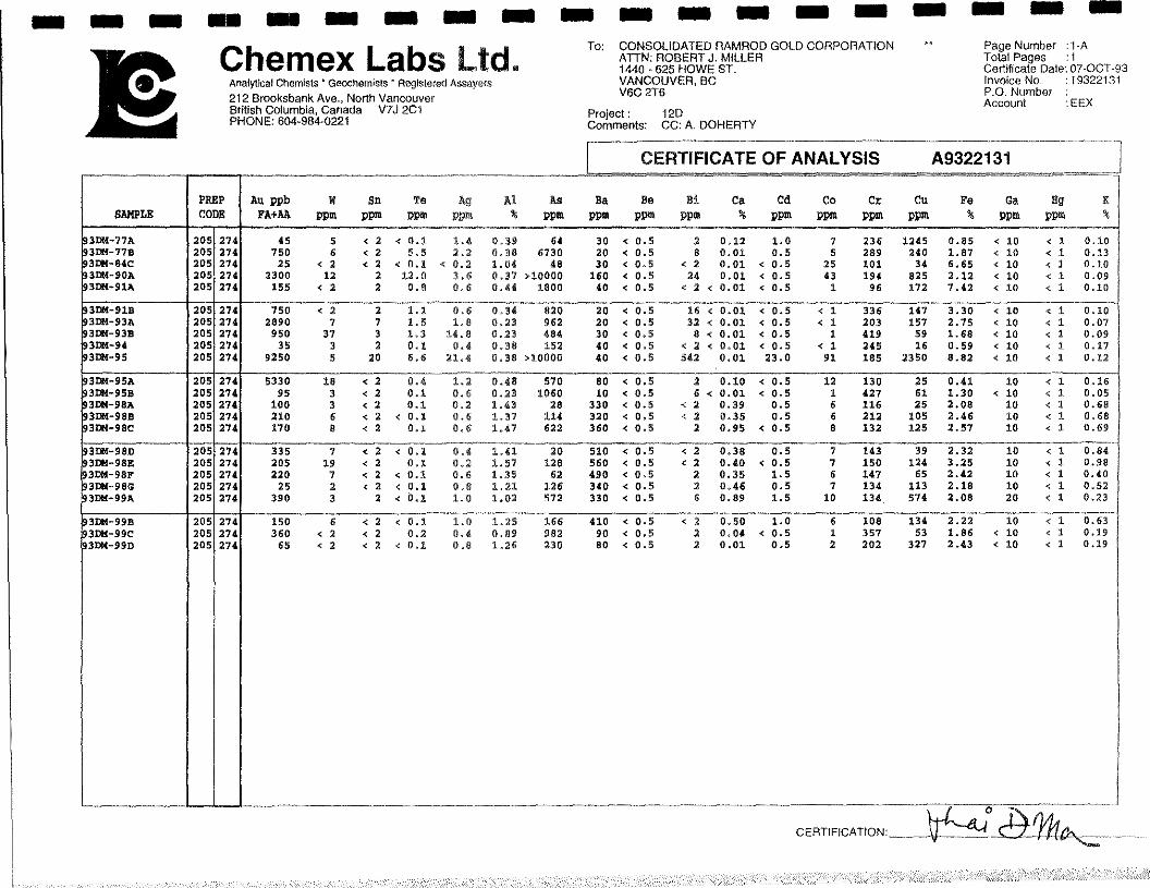
Samples of mineralized quartzvein material were collected by Aurum in 1993. Fourrock samples were taken from the floor of old trenches within the Gossan Zone andreturned values from 80 ppb to >10,000 ppb Au (0.295 opt). The samples consisted ofsheared quartz vein material with disseminated fine gralned arsenopyrite, pyrrhotite andpyrite. Eighteen rock samples were collected from the granite intrusion in 1993. Thesamples consisted of variably altered, and fractured megacrystic granite. Most samplescontalned disseminated pyrite and reported between 25 and 390 ppb gold.Corresponding silver and arsenic values did not exceed 1.8 ppm and 982 ppm,respectively (but, overall, the higher gold values correlate to higher silver and arsenicvalues). For samples taken within the intrusive unit, Bismuth ranges from c 2 to a highof 542 ppm Bi and also correlate well with gold values.
As is typical of the Selwyn Plutonic Suite (and Tombstone Plutonic Suite), hornfelsis moderately well developed adjacent to the granite intrusive (Figure 3). The GossanZone is within the hornfelsed zone. The hornfels commonly contains disseminated andblebby pyrite and pyrrhotite, local quartz - sulfide veins and quartz vein stockworks.Samples of veined or stockwork hornfelsed metasedimentary rocks, commonly withlimonite and trace sulfides, returned local anomalous gold values greater than 10,000 ppbAu (sample # JvR93004), Twenty-nine of forty-seven rock samples collected in 1993,consisted of hornfelsed quartzite and phyllites. The majority of these samples containedquart (+\ tourmaline) stockwork and veins, often with visible sulphides including pyrite,arsenopyrite and, less commonly, traces of pyrrhotite, chalcopyrite, and bornite (eg.sample 93DM 99a). Arsenic and bismuth correlate with high gold results. Rock sample93DM-95, consisting of altered quartzite with sulphide rich quartz and tourmafine veining,returned 9250 ppb Au and coincident arsenic and bismuth highs of >10,000 ppm and 542ppm, respectfully.
AURUM GEOLOGICAL CONSULTANTS INC.
12
GEOCHEMISTRY
1993 Results
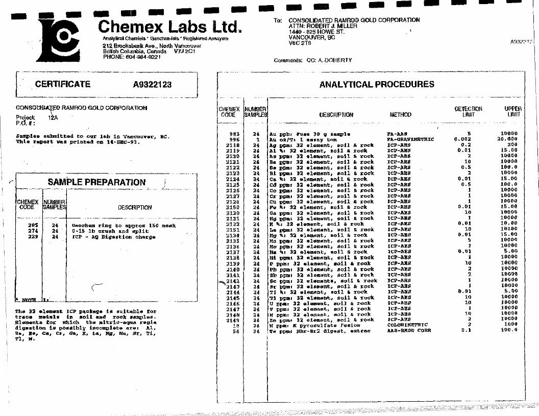
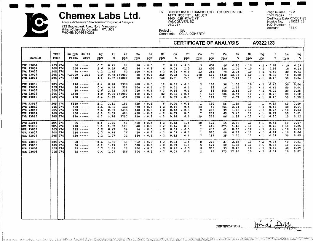
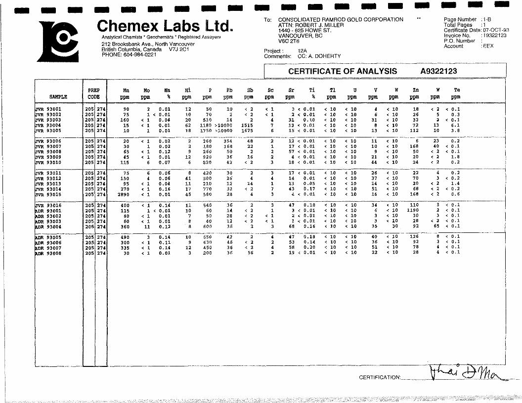
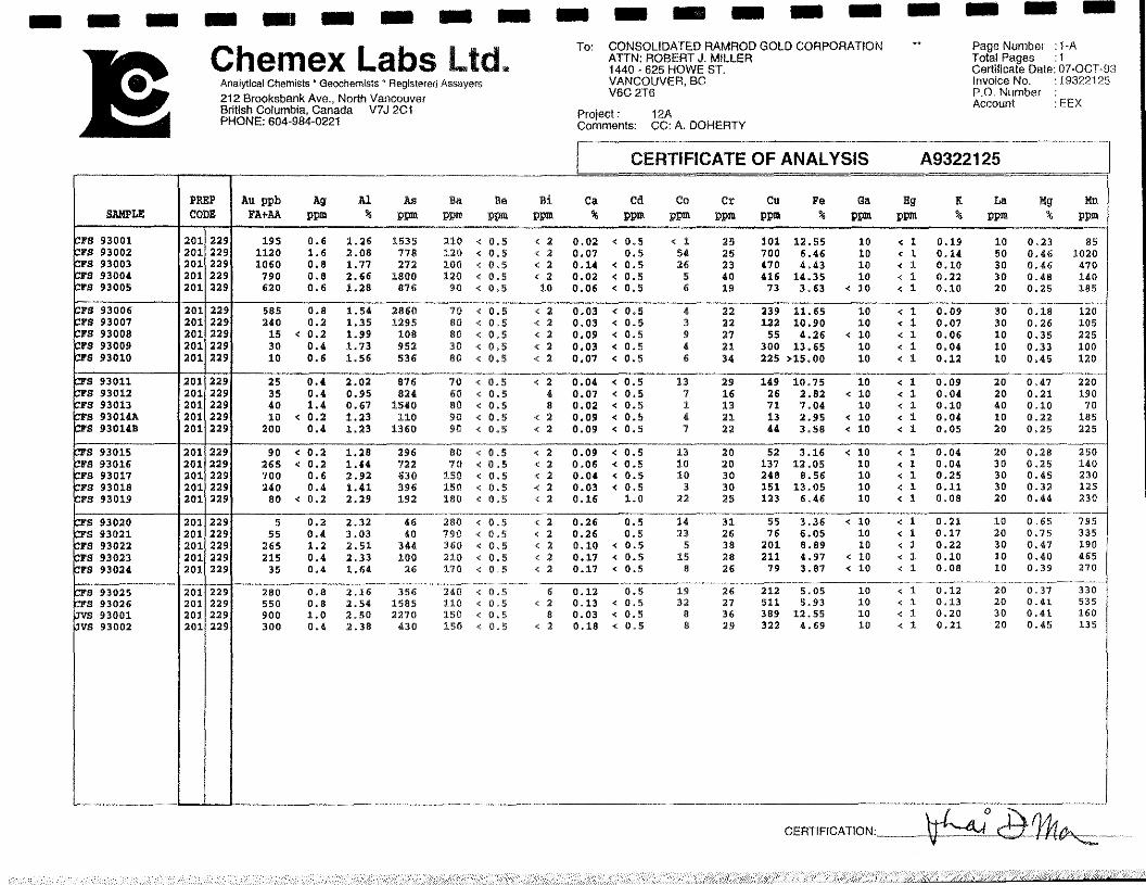
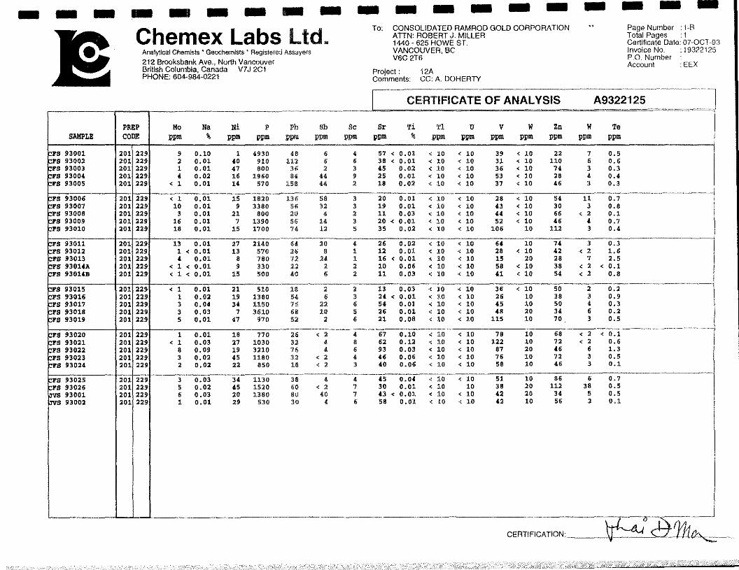
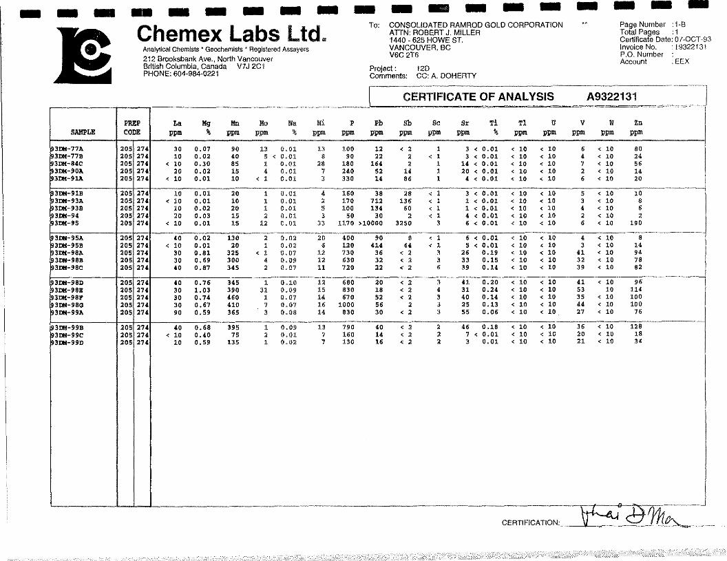
A total of 76 samples (47 rock and 29 soil samples) were collected on or near theRed Mountain property in 1993. Twenty four rock samples and twenty nine soil samplewere collected by Aurum and twenty three rock samples were collected by Murphy andHeon as part of the Canada\Yukon Geoscience mapping project. Most rock samples arefrom outcrop while the remainder are from float. Float samples are from talus and arerepresentative of lithologies located upslope. All samples collected by Aurum and theCanada\Yukon Geoscience mappers (Murphy and Heon, 1994) were analyzed for gold,by fire assay with an AA finish, and for 32 additional elements including As, Bi, W, and Te.Funding for the processing of the rock samples collected by Canada\Yukon Geosciencemappers was provided by Consolidated Ramrod Gold Corporation. Results for the workcarried out in 1994 are shown on Figure 3. Analytical methods and results, and sampledescriptions for all samples are included in Appendices A and B, respectfully.
Amax (Kidlark, 1980) collected ten soil and nine silt samples. The soil sampleswere collected well below the gossan zone and returned values less than 20 ppb gold,1.0 ppm silver, and 72 ppm copper. Of the nine silt samples three were not analyzed forgold. One sample of the remaining six samples returned less than 100 ppb gold whilethe other five returned values between 100 and 400 ppb gold.
A total of 29 soil samples were collected in 1993. The soils were collected alongtwo contour lines (4550 and 4850 foot elevation), adjacent to the Gossan Zone and belowa dike-like structure of the granite stock. Results for gold are generally high (309 ppbaverage) and ranged from 5 ppb up to 1120 ppb gold in soil with reported anomalousvalues for other elements including 2860 ppm As, 10 Bi, and 511 ppm Cu.
GEOPHYSICS
The only geophysical survey known to have been carried out over the property isan airborne magnetic survey (GSC Map 3337G) at an scale of 1:63,360. The RedMountain property covers a circular 300+ gamma (nana tesla) anomaly. This positivemagnetic expression is one of the highest in the region. The anomaly most likelyrepresents pyrite and pyrrhotite in the hornfelsed zone surrounding the granite stock. Asthe magnetic anomaly is larger than the exposed granite stock it is probable that theanomaly reflects shallow buried granite and associated hornfelsed metasediments(Doherty and Hulstein, 1992).
AURUM GEOLOGICAL CONSULTANTS INC.
13
CONCLUSIONS AND RECOMMENDATIONS
The Red Mountain property covers a Cretaceous granite stock and numerousrelated dykes hosted by Lower- Middle(?) Cambrian metasedimentary rocks. The granitestock is part of the Tombstone Plutonic suite, and similar to stocks hosting the Fort Knoxand Dublin Gulch gold deposits, located at Fairbanks, Alaska, and Dublin Gulch, YukonTerritory.
The property is a bulk tonnage, low grade, gold deposit target. Potential may alsoexists for commercial quantities of molybdenum and or tungsten to be found in the granitehost rock, although both elements returned low values in 1993.
Mineralization of most interest is found within the granite stock in zones of alteredand fractured granite. Samples of this material returned up to 390 ppb gold in 1993.Gold quart - sulfide veins have been located within the intrusive and metasediments andsamples of this material returned the highest gold value in 1993,0.295 opt (>10,000 ppb).
Past exploration appears to have concentrated on a prominent gossan zone withinthe hornfelsed metasediments. The presence of gold however is not restricted to thegossan zone as there a widespread gold in soil anomaly over and adjacent to the granitestock on the property. In addition creek drainages are anomalous in gold with extensiveplacer gold workings being found on Gem Creek.
There is a strong (300+ gamma) airborne anomaly over and adjacent to thegranite stock possibly indicating a large zone of magnetic minerals. This magneticanomaly is larger than the exposed granite stock indicating a large portion of the stockremains buried and it has only been partially unroofed,
Based on the positive results of surface exploration carried out on the RedMountain property in 1981, 1992, and 1993 further work is recommended and warranted.A fourteen day exploration program conducted by a crew of three geologists and utilizinga Kubota-41 back-hoe is estimated to cost approximately $90,000. The following workis recommended:
AURUM GEOLOGICAL CONSULTANTS INC.
14
1, Compile a 1:5,000 scale orthophoto map of the Red Mountain propertyincorporating all available geological, geochemical and remote sensing data to betteridentify potential exploration targets.
2. Further exploration consisting of prospecting, geological mapping, rock, soil, andstream silt sediment geochemistry (especially for gold and bismuth) should be carried outover and adjacent to the granite intrusive.
3. A kubota-41 back-hoe should be mobilized to the property to complete trenchingacross soil and overburden covered areas.
4. All the Red claim should be located and tagged and any open ground should bestaked.
4. Any further work (geophysics, trenching, etc.) is contingent on results of the abovework.
Respectfully submitted;
~i~:~Man Doherty, P.Geo,
/7/
March 1, 1994 Jo-Anne vanRanden, B.Sc.
AURUM GEOLOGICAL CONSULTANTS INC.
15
REFERENCES
Abbott, J.G., Gordey, S.P., Tempelman-Kluit D.J., 1986. Setting of stratiform, sediment- hosted lead - zinc deposits in Yukon and Northeastern British Columbia; inMineral Deposits of Northern Cordillera, ed. J.A. Morin, The Canadian Institute ofMining and Metallurgy, Special volume 37, p.1-18.
Aho, A.E., 1962. Prospecting and Mineral Development in Yukon: in Western Miner & OilReview, Vol. 35, No.2, p. 32.
Bostock, H.S., 1964. Geology, McQuesten, Yukon Territory; NTS liSP, scale 1:253,440.Geological Survey of Canada, Map 1 143A.
Crysi Exploration, 1992. Intrusive Hosted Gold Targets, Yukon and British Columbia,Canada. A private report prepared for Kokanee Explorations Ltd., Vancouver, B.C.
DIAND, 1993. Yukon Minfile, WP 5.1 Version, 15,Feb/93; Exploration and GeologicalServices, Department of Indian and Northern Affairs, Whitehorse Yukon.
Doherty, R.A. and Hulstein, R., 1993. Report on the Geological and GeochemicalAssessment Work on the Red Mountain Property, Private report for KokaneeExploration Ltd by Aurum Geological Consultants Inc.
Emond, D.S., 1986. Tin and Tungsten Veins and Skarns in the McQuesten River Area,Central Yukon: in Yukon Geology, Vol.1; Exploration and Geological ServicesDivision, Yukon, Indian and Northern Affairs Canada, p. 113-118
Kidlark, P.G., 1980. Geological and Geochemical Assessment Report on the HI 1-3 and5-97 claims; Amax of Canada Ltd. D.LA.N.D. Assessment Report No, 090559.
Murphy, D.C., Heon, D., and Hunt, J., 1993. Geology of Clear Creek map area, Yukon(NTS 1 i5P/14). Exploration and Geological Services Division, Yukon, Indian andNorthern Affairs canada, Open-File 1993-i, scale 1:50000.
Murphy, D.C. and Heon, D., 1994. Geological overview of Sprague Creek map area,Western Selwyn Basin. In Yukon Exploration and Geology 1993; Exploration andGeological Services DMsion, Yukon, Indian and Northern Affairs Canada.
AURUM GEOLOGICAL CONSULTANTS INC.
16
Robinson, S.D. and Doherty, R.A., 1988. Geological, Geochemical, Geophysical andDiamond Drilling, 1988 Summary Report on the Rum, Rye and Roll Claims,Dawson Mining District, Yukon Territory: Private Report for Goldrite MiningCorporation by Aurum Geological Consultants Inc.
Tempelman-Kluit, D.J., 1979. Transported Cataclasite, Ophiolite and Granodiorite inYukon: Evidence of Arc-Continent Collision; Geological Survey of Canada, Paper79-14.
Tempelman-Kluit, 1981. Geology and Mineral Deposits of Southern Yukon: in YukonGeology and Exploration 1979-80; Geology Section, Department of Indian andNorthern Affairs, Whitehorse Yukon.
Wheeler, J.O. and McFeely, P., 1991. Tectonic Assemblage Map of the CanadianCordilleras and Adjacent parts of the United States of America; Geological Surveyof Canada, Map 1712A, scale 1:2,000,000.
AURUM GEOLOGICAL CONSULTANTS INC.
17
STATEMENT OF QUALIFICATIONS (RAD)
I, R. Allan Doherty, hereby certify that:
1. I am a geologist with AURUM GEOLOGICAL CONSULTANTS INC., 205 - 100 MainStreet, P.O. Box 4367, Whitehorse, Yukon, Y1A 3T5.
2. I am a graduate of the University of New Brunswick, with a degree in geology(Hons. B.Sc., 1977) and that I attended graduate school at Memorial University ofNewfoundland, 1978-80. I have been involved in geological mapping and mineralexploration continuously since then.
3. I am a member of the Association of Professional Engineers and Geosc!ientists ofthe Province of British Columbia, Registration No. 20564 and of the CIMM.
4. I am co-author of this report on the Red Mountain Property of ConsolidatedRamrod Gold Corporation which is based on information collected during propertywork completed September 13-15, 1993 and October 13, 1992, and on referencedsources.
5. I have no direct or indirect interest in the properties or securities of ConsolidatedRamrod Gold Corporation.
6. I consent to the use of this report by Consolidated Ramrod Goldprovided that no portion is used out of context in such a manner asmeaning differing materially from that set out in the whole,
March 1, 1994
Corporationto convey a
R. Allan Doherty, P.Geo.
AURUM GEOLOGICAL CONSULTANTS INC.
18
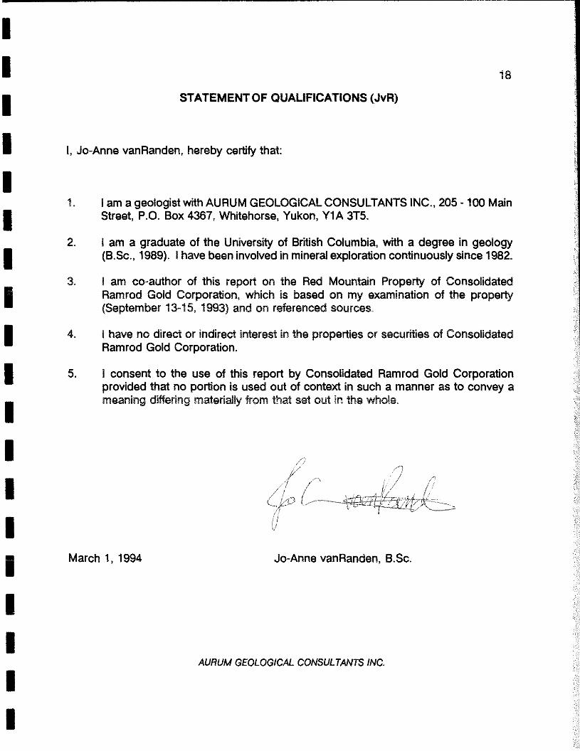
STATEMENT OF QUALIFICATIONS (JvR)
I, Jo-Anne vanRanden, hereby certify that:
1. I am a geologist with AURUM GEOLOGICAL CONSULTANTS INC., 205 - 100 MalnStreet, P.O. Box 4367, Whitehorse, Yukon, Y1A 3T5.
2. I am a graduate of the University of British Columbia, with a degree in geology(B.Sc., 1989). I have been involved in mineral exploration continuously since 1982.
3. I am co-author of this report on the Red Mountain Property of ConsolidatedRamrod Gold Corporation, which is based on my examination of the property(September 13-15, 1993) and on referenced sources.
4. I have no direct or indirect interest in the properties or securities of ConsolidatedRamrod Gold Corporation.
5. I consent to the use of this report by Consolidated Ramrod Gold Corporationprovided that no portion is used out of context in such a manner as to convey ameaning differing materially from that set out in the whole,
March 1, 1994 Jo-Anne vanRanden, B.Sc.
AURUM GEOLOGICAL CONSULTANTS INC.
19
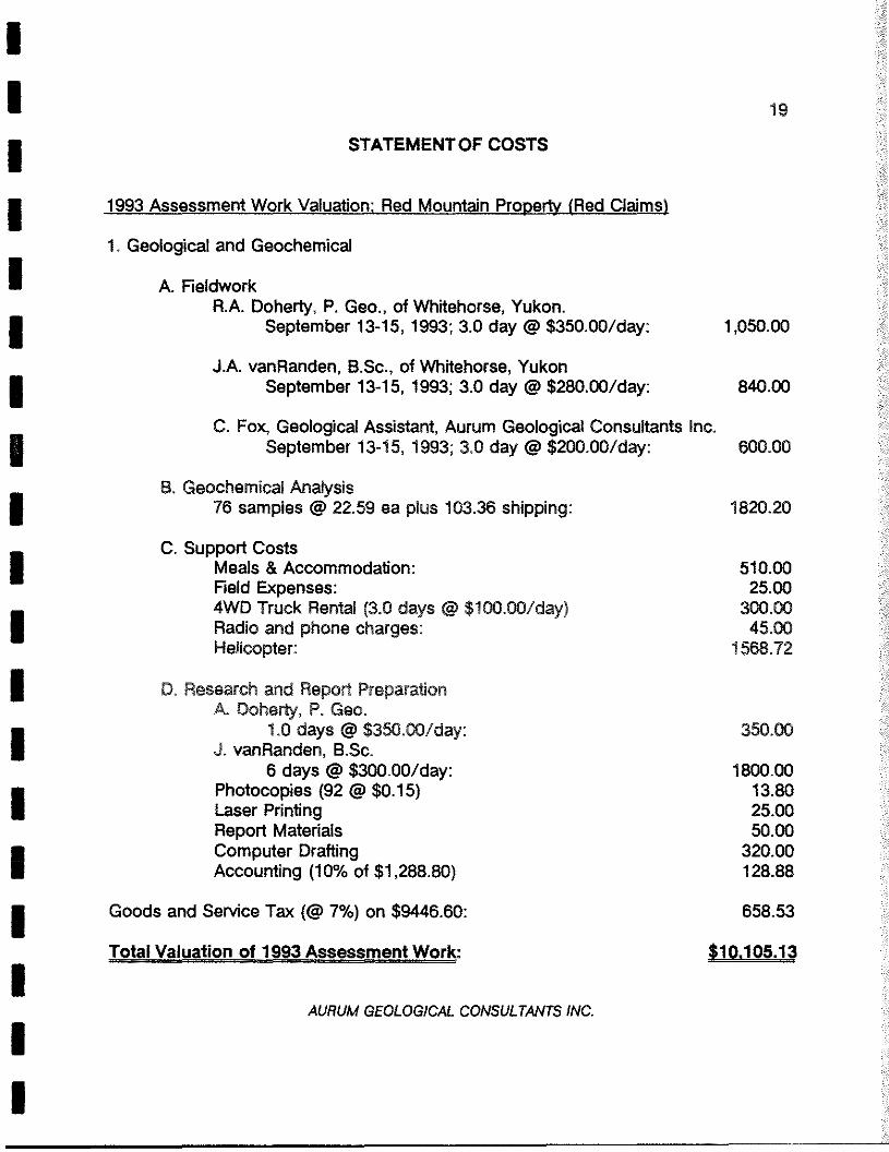
STATEMENT OF COSTS
1993 Assessment Work Valuation; Red Mountain Property (Red Claims)
1. Geological and Geochemical
A. FieldworkR.A. Doherty, P. Geo., of Whitehorse, Yukon.
September 13-15, 1993; 3.0 day @ $350.00/day: 1,050.00
J.A. vanRanden, B.Sc., of Whitehorse, YukonSeptember 13-15, 1993; 3.0 day @ $280.00/day: 840.00
C. Fox, Geological Assistant, Aurum Geological Consultants Inc.September 13-15, 1993; 3,0 day @ $200.00/day: 600.00
B. Geochemical Analysis76 samples @ 22.59 ea pIus 103.36 shipping: 1820.20
C. Support CostsMeals & Accommodation: 510.00Field Expenses: 25.004WD Truck Rental (3.0 days @ $100.00/day) 300.00Radio and phone charges: 45.00Helicopter: 1568.72
D. Research and Report PreparationA, Doherty, P. Geo,
1.0 days @ $350.00/day: 350.00J. vanRanden, B.Sc.
6 days @ $300.00/day: 1800.00Photocopies (92 @ $0.15) 13.80Laser Printing 25.00Report Materials 50.00Computer Drafting 320.00Accounting (10% of $1,288.80) 128.88
Goods and Service Tax (@7%) on $9446.60: 658.53
Total Valuation of 1993 Assessment Work: $10,105.13
AURUM GEOLOGICAL CONSULTANTS INC.
aa
aa
aa
aa
a—
aa
aa
—a
aa
:3 a C, U,
-ø~
.u
r~m
o~
a ~l)
—U
,X
:3 a. CD V 0 0) /K
~7
a SI a : — — — a — —
Chernex Labs Ltd To CONSOLIDATED RAMROD GOLD CORPORATIONATTN: ROBERT J. MILLER1440~825 HOWEST.Ac.aIylItat ChernIstvGeocbam,SMs’flogbiflwS Assa~em VANCOUVER, BC
V6C 216 fl32:l:’.]212 BreoksbmmkAve., Worth VanvonvwSnitch Columbia Canada V7J 201PHONE:6O4-984~U�21 ComemondE CC: A. DOHERTY
[cERTh~CATE A9322123 JCONSOU9~fE0RAMROD GOLD CORPORATION
1~A
Satriptis saheitted Ito our lab in VftScDUV.r, BC.This report wan printed on 14-DEC-93.
CUEMEX NUMBERcODE SAMPLES DESCRIPTION
asootten,ring to approx 150 mesh0-15 lb crush rind splitIC? - 3Q Digestion charge
C
The 32 element ia’ package in suitable fortrace mutate in soil end rock a~”w1~~~Sluaents for which the nitric-aqua regiadigeetton is possibly incomplete are* Al,Ba,, Be, Ca, Cr, Ga, It, isa, 55, Na, at, ‘!ri,Ti, W.
CHEMEXCODE
903996
3118211921.2021213122212331242135213631272 12~3150313021.3121322152,2134213.5213~313722.362139314031.41.
2144314521462147nfl2149
1054
WUMBERSAMPLES
241.
24242424242424243424242434243434242424242424242424
2424242434243424
AU ppb: tuse 30 g sampleA~*oZtDt I tflSri~( tonAg ppm: 33 element, soil A rockAt ‘&i 32 element, soil e tacitIts ppm: 32 element, soil & rockBa ppm: 32 element, nail & rock~e ppma 32 element, soil & rockSi ppm: 32 element, soil I rockCa In 32 element, soil. & rockCd ppm: 32 element, nail & rookCo ppm. 32 element, nail I rockOr ppm. 32 element, nail & rackCU ppns 32 element, poll A rookPa ‘Kt 32 element, soil I rack04 ppin~ 32 element, sail I rocklIg ppm. 32 element, soil & rookit tj~ 32 element, soil a. rockLa ppm: 32 element, soil I rockHg Iti 32 element, soil & rackMn ppm. 32 element, soil & rockMo ppm: 32 element, soil I rockNa ‘si 32 element, soil I rock
FA-AASF&-OIUtVIHZTRIC1CP-3.3$IC?-fl S102—ASSIt P—ABS102-ABSlop-ASSlcD-ABS102-3.23IC?-ABS103-ASSlCD-ASSIC?lCD-ASSIC?“ABSlop-USrep-ABS103-ABSlCD-ARE103-ABS1cm-ABSICP-ABSlop-na102-ABSlC3-ABS102—ABSIC?-JIBElCD-ASSloP-ABS101’-3H S102-ASSIC?-330IC?-3.313001,0kH4ZTh1CAAS~-Bfi0DCORE
S0,002
0,20.01
210
0,52
0,010,5
II1
0,0110
I0,01
103,01
SI
0.011
1022
0.011010
1022
0.1
1000020.000
P40015.001000010000100.01000015,00100,01.0000100001000015,00100001000010,001000015 .0010000100005,00
10000100001.000010006100001.0000s~&0
100002.00001000010001)10000
1000100.4)
ANALYTICAL PROCEDURES
DESCRIPTION
SAMPLE ‘PREPARATION
METHODlION
LIMIT
205274239
UPPERLIMIT
242424
1.
lit ppm: 32 element, soil. & tackP ppmi 32 eleaent
1soil & rook
Pb ppm. 32 element, nail & rockSb ppm. 32 element, soil & rockSc ppmi 32 elements, soil I rockSr ppm% 32 element, soil & rockTi ‘Li 32 eLement, soil s rockTi ppma 32 element, soil & rockU ppm; 32 element, soil & rockV ppm, 33 element, enil t rockIt ppm; 32 alemoet, poll & rockZn ppm. 32 eLement, soil & rockPt ppm, It pyro*lultate fU5ioH
We p1’m~ liar-nfl digest, entrac
a — a a — — — — a — a — — — — — — — aChemex Labs Ltd.
Analytical Chemists’ Geochernists ‘ Registered Assayers212 Brooksbank Ave., North VancouverBritish Columbia, Canada V7J 2C1PHONE: 604’984~0221
To: CONSOLIDATED RAMROD GOLD CORPORATIONATTN: ROBERTJ. MILLER1440 625 HOWE ST.VANCOUVER, BCV6C 2T6
Project : 1 2AComments: CC: A, DOHERTY
CERTIFICATE OF ANALYSIS
Page Number :1~ATotal Pages :1Certificate Date: 07-OCT~93Invoice No. :19322123P.O. NumberAccount :EEX
A9322123
831WLEPREPCODE
AuppbAuPk Ag Al As Ba Be Bi Ca Cd Co Cr Cu £~ Ga fig K La Mg?A+AA 0: IT ppm ~ ppm ppm ppm ppm % ppm ppm ppm ppm % ppm ppm % ppm %
~VR93001rva 93002‘YR 93003rVR 93004rvn 93005
205205205205205
274274274274274
80 0.2 0,23 94 10 < 0.5 2 0.11 < 0.5 3 657 46 0.86 < 10 < 1 0.01 10 0,09560 2.6 0,49 612 40 .~0,5 4 0.05 1,0 22 404 336 1.09 < 10 < 1 0.08 10 0.2290 0.2 1,75 60 300 < 0,5 c 2 0.23 c 0.5 13 266 70 2.03 10 < 1 0.63 20 0.75
>10000 0.295 6.0 0.58 >10000 40 < 0.5 358 0.02 6.0 218 102 1340 13.95 < 10 < 1 0.22 10 0.023340 4.4 0,87 >10000 90 < 0.5 148 0.01 7.5 37 95 1040 7.71 10 < 1 0.40 30 0.04
WE 93006)VR 93007lYE 93008YVR 93009WE93010
205205205205205
274274274274274
290 0.4 0.98 2930 200 <0.5 12 0.01 < 0,5 2 108 38 1.06 10 < 1 0.48 30 0.0480 0.4 0.99 538 200 .t 0.5 c 2 0.01 0.5 1 99 16 1.29 10 ‘C 1 0.45 50 0.0480 0.6 2.82 334 210 < 0,5 < 2 0.14 0.5 3 58 160 2.44 10 < 1 0.29 20 0.35
1670 4.0 0.85 >10000 110 < 0.5 22 0,06 0.5 1 475 226 2.57 10 < 1 0.22 20 0.10450 0.4 1.82 434 320 c 0.5 < 2 0.03 0,5 1 122 77 4.07 10 < 1 0.45 30 0.35
WE93011lYE 93012I’VE 93013I’VE 93014I’VE 93015
205 274205 274205 274205 274205 274
6340 2.2 2.11 196 420 < 0.5 6 0.06 < 0.5 1 130 55 1.89 10 1 0.59 40 0.40500 0.6 2.06 122 330 .c 0.5 < 2 0.10 0.5 13 82 254 3.01 10 < 1 0.58 30 0.61230 1.4 0.65 1430 140 ‘C 0.5 < 2 0.10 c 0.5 2 400 39 1.70 < 10 c 1 0.23 < 10 0.24100 0.2 2.59 400 450 c 0.5 c 2 0.33 0.5 7 202 65 3.15 10 1 0.97 20 1.01840 0.2 0.76 3700 120 0.5 c 2 0.14 0,5 19 276 86 2.38 c 10 < 1 0.30 10 0.12
WE93016U~93001WE 93002WE 93003WE 93004
205205205205205
274274274274274
55 0.4 1.56 56 350 C 0.5 < 2 0.42 1.5 10 172 45 2.36 10 < 1 0.55 40 0.67210 1.8 0.52 120 40 c 0.5 < 2 0.16 8.5 7 416 375 1.40 10 c 1 0.12 ‘C 10 0.25115 0.2 0.27 54 10 < 0.5 < 2 0.02 ‘C 0.5 1 438 41 0.88 < 10 < 1 0.02 C 10 0.13130 0.2 0.18 26 10 < 0,5 < 2 0.02 < 0,5 1 530 40 0.73 < 10 C 1 0.01 C 10 0.06110 0.2 1.27 22 340 < 0.5 < 2 0.62 0.5 7 187 25 2.20, 10 1 0.71 30 0.65
tEE 93005IDE 93006tilE 93007WE93008
205205205205
274274274274
50 0.4 1,6118 350<0.5 < 2 0.62 1.5 8 209 27 2.49 10 C 1 0.73 40 0.8350 0.2 1.19 28 300 c 0.5 < 2 0.59 1.0 5 129 32 1.82 10 1 0.58 40 0.6325 0.2 1.58 22 450 C 0.5 < 2 0.42 ‘C 0.5 8 216 53 2.48 10 c 1 0.99 40 0.8985 0.4 1.06 486 100 < 0.5 c 2 0.02 0.5 1 98 173 12.85 10 C 1 0.32 10 0.02
CERTIFICATION:V -‘-—
I a a a a a a a a a a a a a a a a a a aChemex Labs Ltd.
Analytical Chemists ‘ Geochemists Registered Assayers
212 Brooksbank Ave., North VancouverBritish Columbia, Canada V7J 2C1PHONE: 604~984-022l
To: CONSOLIDATEDRAMROD GOLDCORPORATIONAnN: ROBERT J. MILLER1440~625 HOWE ST.VANCOUVER,BCV6C 2T6
Project: 12AComments: CC: A. DOHERTY
CER11FICATE OF ANALYSIS
Page Number :1-BTotalPages :1Certificate Date: 07-OCT-93Invoice No, :19322123P.O. NumberAccount :EEX
A9322123
Mn Mo Na Ni P Pb Sb Sc Sr Ti fl ii V W Zn It Tappm ppm % ppm ppm ppm ppm ppm ppm 9~ ppm ppm ppm ppm ppm ppm ppm
I’VE 93001I’VE 93002I’VE 93003I’VE 93004WE93005
205205205205205
274274274274274
90 2 0.01 12 50 10 C 2 C 1 3 C 0.01 C 10 C 10 4 C 10 18 C 2 C 0.175 1 C 0.01 10 70 2 C 2 C 1 2 C 0,01 C 10 C 10 6 C 10 26 5 0.3
160 C 1 0.04 20 510 14 2 4 31 0.10 C 10 C 10 31 C 10 32 2 C 0.115 C 1 0.01 62 1180 >10000 1515 7 13 C 0.01 C 10 C 10 8 C 10 72 13 6.110 1 0.01 18 1750 >10000 1675 6 15 C 0.01 C 10 C 10 13 C 10 112 10 3.8
I’VE 93006I’VE 93007I’VE 93008WE93009WE93010
205205205205205
274274274274274
20 C 1 0,02 2 260 354 48 2 12 C 0.01 C 10 C 10 11 C 10 6 23 0.230 1 0.02 2 180 168 22 1 17 C 0.01 C 10 C 10 10 C 10 168 40 C 0.165 C 1 0.12 9 260 50 2 2 57 C 0.01 C 10 C 10 9 C 10 50 C 2 C 0.145 C 1 0,01 12 920 36 16 2 4 C 0.01 C 10 C 10 21 C 10 20 C 2 1.8
115 6 0.07 6 820 42 C2 3 18C0,01 ClO ClO 44 ClO 24 <2 0.2
75 6 0.06 8 420 30 2 3 17 C 0.01 C 10 C 10 26 C 10 22 4 0.2150 4 0.06 41 500 26 4 4 14 0.01 C 10 C 10 37 C 10 70 3 C 0.2
95 C 1 0,04 11 210 12 14 1 13 0.05 C 10 C 10 14 C 10 20 < 2 1.4270 C 1 0.16 17 770 32 C 2 7 43 0.17 C 10 C 10 51 C 10 68 C 2 C 0.2
2890 C 1 0.01 45 580 28 4 3 4 C 0.01 C 10 C 10 16 C 10 168 C 2 0.6
I’VE 93011I’VE 93012WE93013WE 93014I’VE 93015
205205205205205
274274274274274
WE93016LEE 93001IDE 93002IDE 93003iDE 93004
205274205 274205 274205 274205 274
400 Cl 0.14 11 540 36 2 3 47 0.18 ClO ClO 34 ClO 110 3 C0.1115 1 C 0.01 10 60 14 C 2 1 3 C 0.01 C 10 C 10 6 C 10 1190 2 C 0.1
60 C 1 0.01 7 50 28 C 2 C 1 2 C 0.01 C 10 C 10 3 C 10 30 3 C 0.160 C 1 0.01 8 40 12 C 2 C 1 1 C 0.01 C 10 C 10 3 C 10 28 C 2 C 0.1
360 11 0.12 ‘ 8 600 36 2 3 68 0.16 C 10 C 10 35 30 92 65 C 0.1
LEE 93005JIE 93006DR 93007iDE 93008
205205205205
274274274274
490 3 0.14 10650 42 2 4 47 0.18 C 10 C 10 40 C 10 126 6 C 0.1300 C 1 0.11 9 630 46 C 2 2 53 0.14 C 10 C 10 36 C 10 92 3 C 0.1335 C 1 0,14 12 450 36 C 2 4 58 0.20 C 10 C 10 51 C 10 78 4 C 0.1
30 C 1 0,01 3 200 36 56 2 19 C 0.01 C 10 C 10 22 C 10 28 4 C 0.1
-__---~___ -
CERTIFICATION:\yLd~~
PREPSAMPLE CODE
a a a a a a a a a a a a a a a a a a a
Chemex Labs Ltd.Analytical Chemists • Geochemists - Regislered Assayers212 Brooksbank Ave., North VancouverBritish Columbia, Canada V7J 2C1PHONE:604-984~0221
To: CONSOLIDATEDRAMROD GOLDCORPORATIONAUN: ROBERTJ. MILLER1440 - 625 HOWEST.VANCOUVER,BCV6C 2T6
Project: 12AComments: CC: A. DOHERTY
CERTIFICATE OF ANALYSIS
Page Number :1-ATotal Pages : 1Certificate Date: 07-OCT-93invoice No. :19322125P.O. NumberAccount :EEX
A9322125
SAMPLEPREPCODE
Auppb Ag Al Ac Ba Be Bi Ca Cd Co Cr Cu Fe Ga fig K La Mg MnFM-Ak ppm ‘S ppm ppm ppm ppm 9~ ppm ppm ppm ppm ‘S ppm ppm ‘S ppm ‘S ppm
F8 93001F$ 93002
~FS 93003~FS 93004~‘S 93005
201 229201 229201 229201 229201 229
195 0.6 1.26 1535 210 C 0.5 C 2 0.02 C 0.5 C 1 25 101 12.55 10 C 1 0.19 10 0.23 851120 1.6 2.08 778 120 C 0.5 C 2 0.07 0.5 54 25 700 6.46 10 C 1 0.14 50 0.46 10201060 0.8 1,77 272 100 C 0.5 C 2 0.14 C 0.5 26 23 470 4,43 10 C 1 0.10 30 0.46 470790 0.8 2.66 1800 120 C 0.5 C 2 0.02 C 0.5 5 40 416 14.35 10 C 1 0.22 30 0.48 140620 0.6 1.28 876 90 C 0,5 10 0.06 C 0.5 6 19 73 3.63 C 10 C 1 0.10 20 0.25 185
F8 93006 —
~FS 93007:ps 93008~FS 93009~FS 93010
201229201 229201 229201 229201 229
585 0.8 1.54 2860 70 C 05 C 2 0.03 C 0.5 4 22 239 11.65 10 C 1 0.09 300.18120240 0.2 1.35 1295 80 C 0.5 C 2 0.03 C 0.5 3 22 122 10.90 10 C 1 0.07 30 0.26 10515 C 0.2 1.99 108 80 C 0.5 C 2 0.09 C 0.5 9 27 55 4.26 C 10 C 1 0.06 10 0.35 22530 0.4 1.73 952 30 C 0.5 C 2 0.03 C 0.5 4 21 300 13.65 10 C 1 0.04 10 0.33 10010 0.6 1.56 536 80 C 0,5 C 2 0.07 C 0.5 6 34 225 >15,00 10 C 1 0.12 10 0.45 120
25 0.4 2.02 876 7O~0.5 C 2 0.04 C 0.5 13 29 149 10.75 10 C 1 0.09 20 0.47 22035 0.4 0.95 824 60 C 0.5 4 0.07 C 0.5 7 16 26 2.82 C 10 C 1 0.04 20 0,21 19040 1.4 0.67 1540 80 C 0,5 8 0.02 C 0.5 1 13 71 7.04 10 C 1 0.10 40 0.10 7010 C 0.2 1.23 110 90 C 0.5 C 2 0.09 C 0.5 4 21 13 2.95 C 10 C 1 0.04 10 0.22 185
200 0.4 1.23 1360 90 C 05 C 2 0.09 C 0.5 7 22 44 3.58 C 10 C 1 0.05 20 0.25 225
FS 93011~FS 93012FS 93013
~FS93014k~TS 9301gB
201 229201 229201 229201 229201 229
~PS93015~FS 93016~F8 93017~FS 93018~FS 93019
201 229201 229201 229201 229201 229
90 C 0.2 1.28 296 80 C 0.5 C 2 0.09 C 0,5 13 20 52 3.16 C 10 C 1 0.04 20 0.28 250265 C 0.2 1.44 722 70 C 0,5 C 2 0.06 C 0.5 10 20 137 12,05 10 C 1 0.04 30 0.25 140700 0.6 2.92 630 150 C 0.5 C 2 0.04 C 0.5 10 30 248 8.56 10 C 1 0.25 30 0.45 230240 0.4 1.41 396 150 C 0,5 C 2 0.03 C 0.5 3 30 151 13.05 10 C 1 0.11 30 0.32 12580 C 0.2 2.39 192 180 C 0,5 C 2 0.16 1.0 22 25 123 6.46 10 C 1 0.08 20 0.44 230
~FS 93020~FS 93021~FS 93022E5 93023
~FS 93024
201 229201 229201 229201 229201 229
5 0.2 2.32 46 280 C 0.5 C 2 0.26 0.5 14 31 55 3.36 C 10 C 1 0.21 10 0.65 79555 0.4 3.03 40 790 C 0,5 C 2 0.26 0.5 23 26 76 6.05 10 C 1 0.17 20 0.75 335
265 1.2 2.51 344 360 C 0.5 C 2 0.10 C 0.5 5 38 201 8.89 10 C 1 0.22 30 0,47 190215 0.4 2.33 100 210 C 0.5 C 2 0.17 C 0.5 15 28 211 4.97 C 10 C 1 0.10 10 0.40 465
35 0,4 1.64 26 170 C Oji C 2 0.17 C 0.5 8 26 79 3.87 C 10 C 1 0.08 10 0.39 270
~FS 93025 201 229 380 0,8 3,16 356 240 C 0.5 6 0.12 0.5 19 26 212 5.05 10 C 1 0.12 20 0.37 330~FS 93026 201 229 550 0.8 2.54 1585 110 C 0.5 C 2 0.13 C 0.5 32 37 511 5.93 10 C 1 0.13 20 0.41 53511/5 93001 201 229 900 1.0 2,50 2270 150 C 0.5 8 0.03 C 0.5 8 36 389 12.55 10 C 1 0.20 30 0.41 160TV’S 93002 201 229 300 0.4 2.38 430 150 C 0.5 C 2 0.18 C 0,5 8 29 322 4.69 10 C 1 0.21 20 0.45 135
CERTIFICATION:_____
a a a — a a a a a a a a a a a a a a aChemex Labs Ltd.
Analytical Chemists ‘ Geochemists’ Registered Assayers212 Brooksbank Ave., North VancouverBritish Columbia, Canada V7J 2C1PHONE: 604~984-0221
To: CONSOLIDATEDRAMRODGOLDCORPORATIONAUN: ROBERTJ. MILLER1440 - 625 HOWE ST.VANCOUVER, BCV6C 2T6
Project: 12AComments: CC: A. DOHERTY
CERTIFICATE OF ANALYSIS
Page Number : 1~BTotal Pages :1Certificate Date: 07~OCT-93invoice No. :19322125P.O. NumberAccount : EEX
A93221 25
SAMPLEPREPCODE
Mo Na Ni P Pb Sb Sc Sr Ti Tl U V W Zn W Tappm ‘S ppm ppm ppm ppm ppm ppm ‘S ppm ppm ppm ppm ppm ppm ppm
:n 93001~PS 93002~FS 93003;fl 93004~F8 93005
201 229201 229201 229201 229201 229
9 0.10 1 4930 48 6 4 57 C 0.01 C 10 C 10 39 C 10 22 7 0,52 0.01 40 910 112 6 6 38 C 0.01 C 10 C 10 31 C 10 110 6 0.61 0.01 47 800 36 2 3 45 0.02 C 10 C 10 36 C 10 74 3 0.34 0.02 16 1960 84 44 9 25 0.01 C 10 C 10 53 C 10 28 4 0.4
C 1 0.01 14 570 158 44 2 18 0.02 C 10 C 10 37 C 10 46 3 0.3
~PS 93006:n 93007~FS 9300878 93009
:rs 93010
201229201 229301 229201 229201 229
Cl 0.01 15 1820 136 58 3 20 0.01 C1OC 10 28 C 10 54 11 0.710 0.01 9 3380 56 32 3 19 0,01 C 10 C 10 43 C 10 30 3 0.8
3 0.01 21 800 20 4 2 11 0,03 C 10 C 10 44 C 10 66 C 2 0.116 0.01 7 1390 56 14 3 20 C 0.01 C 10 C 10 52 C 10 46 4 0.718 0.01 15 1700 74 12 5 35 0.02 C 10 C 10 106 10 112 3 0.4
~rS 93011~F5 93012:n 93013;rs 93014k~FS 93014B
201 229201 229201 229201 229201 229
13 0.01 27 2140 64 20 4 26 0.02 C 10 C 10 64 10 74 3 0,31 C 0.01 13 570 26 8 1 12 0.01 C 10 C 10 28 C 10 42 C 2 1.64 0.01 8 780 72 24 1 16 C 0,01 C 10 C 10 15 20 28 7 2.5
C I C 0.01 9 330 23 2 2 10 0.06 C 10 C 10 58 C 10 38 C 2 C 0.1C 1 C 0.01 15 500 40 6 2 11 0.03 C 10 C 10 41 C 10 54 C 2 0.8
P893015PS 93016P5 93017PS 93018PS 93019
301229201 229201 229201 229201 229
Cl 0.01 21 510 18 2 2 13 0.03 ClO ClO 36 ClO 50 2 0.21 0.02 19 1380 54 6 3 24 C 0.01 C 10 C 10 26 10 38 3 0.93 0.04 34 1150 76 32 6 54 0,01 C 10 C 10 45 10 50 4 0.33 0.03 7 3610 68 10 5 26 0.01 C 10 C 10 48 20 34 6 0.25 0.01 47 P70 53 2 6 21 0.08 C 10 C 10 115 10 70, 3 0.5
-~FS93020~FS93021PS 93022PS 93023~pS 93024
301 229201 229201 229201 229201 229
1 0.01 18 770 26C2 4 67 0.10 C 10 C 10 78 10 68 C 2 C 0.1C 1 0.03 27 1030 32 4 8 62 0.12 C 10 C 10 122 10 72 C 2 0.6
8 0.09 19 3210 76 4 6 93 0.03 C 10 C 10 87 20 46 6 1.33 0.02 45 1180 32 C 2 4 46 0.06 C 10 C 10 76 10 72 3 0.52 0.02 22 850 18 C 2 3 40 0.06 C 10 C 10 58 10 46 3 0.1
3 0.03 34 1130 384 4 45 0.04 C 10 C 10 51 3M 86 6 0.75 0.02 45 1520 60 C 2 7 30 0.01 C 10 10 38 20 112 38 0.56 0.03 20 1380 80 40 7 43 C 0.01 C 10 C 10 42 20 34 5 0.51 0.01 29 530 30 4 6 58 0.01 C 10 C 10 42 10 56 2 0,1
~P’S930251F8 93026‘pm 93001in 93002
201 229201 229201 229201 229
\tLA°~?O41~,~CERTIFICATION:Y
a a a a a a a a a a a a a a a a a a aChemex Labs Ltd.
Analytical Chemists ‘ Geochemists ‘ Registered Assayers
212 Brooksbank Ave., North VancouverBritish Columbia, Canada V7J 2C1PHONE: 604.984~022l
To: CONSOLIDATEDRAMRODGOLDCORPORATIONAUN: ROBERT J. MILLER1440 - 625 HOWEST.VANCOUVER,BCV6C 2T6
Project: 12DComments: CC: A. DOHERTY
flCERTIFICATE OF ANALYSIS
Page Number :1’ATotal Pages : 1Certificate Date: 07-OCT-93Invoice No. :19322131P.O. NumberAccount : EEX
A9322131
SAMPLEPREPCODE
Auppb W Sn Ta Ag Al AS Ba Be Di Ca Cd Co Cr Cu Fe Ga Mg KPA+AA ppm ppm ppm ppm ‘S ppm ppm ppm ppm ‘S ppm ppm ppm ppm ‘S ppm ppm ‘S
I3DM—77A131*4—77813D44—84C131*4-90k131*4—91k
205 274205 274205 274205 274205 274
45 5 C 2 C 0.1 1,4 0.39 64 30 C 0.5 2 0.12 1.0 7 236 1245 0.85 C 10 C 1 0.10750 6 C 2 5,5 2.2 0.38 6730 20 C 0.5 8 0.01 0.5 5 289 240 1.87 C 10 C 1 0.13
25 C 2 C 2 C 0,1. C 0.2 1.04 48 30 C 0.5 C 2 0.01 C 0.5 25 101 34 6.65 C 10 C 1 0.102300 12 2 12.0 3.6 0,37 >10000 160 C 0.5 24 0.01 C 0.5 43 194 825 2.12 C 10 C 1 0.09
155 C 2 2 0.8 0.6 0,44 1800 40 C 0.5 C 2 C 0.01 C 0.5 1 96 172 7.42 C 10 C 1 0.10
131*4-918I3EM—93k131*1—938131*4—94131*4—95
205 274205 274205 274205274205 274
750 C 2 2 1.1 0,60.34 820 20 C 0.5 16 C 0.01 C 0.5 C 1 336 147 3.30 C 10 C 1 0.103890 7 7 1.5 1,8 0.23 962 20 C 0.5 33 C 0.01 C 0.5 C 1 203 157 2.75 C 10 C 1 0.07
950 37 3 1.3 14,8 0.23 484 30 C 0.5 8 C 0.01 C 0.5 1 419 59 1.68 C 10 C 1 0.0935 3 2 0.1 0.4 0.38 152 40 C0.5 C2CO,01 C0.5 Cl 245 16 0.59 ClO Cl 0.17
9250 5 20 6,6 21,4 0,38 >10000 40 C 0.5 542 0.01 23.0 91 185 2350 8.82 C 10 C 1 0.12
131*4—95k131*1—958131*4—98k131*1-988131*4—98C
205274205 274205 274205 274205 274
5330 18 C 20,4.1.20,48 570 80 C 0.5 2 0.10 C 0.5 12 130 25 0.41 IOC1 0,1695 3 C 3 0.1 0,6 0.23 1060 10 C 0.5 6 C 0.01 C 0.5 1 427 61 1.30 C 10 C 1 0.05
100 3 C 2 0.1 0.2 1.43 38 330 C 0.5 C 2 0.39 0.5 6 116 25 2.08 10 C 1 0.68210 6 C 2 C 0.1 0.6 1,37 114 320 C 0.5 C 2 0.35 0.5 6 212 105 2.46 10 C 1 0.68170 8 C 2 0,1 0.6 1.47 622 360 C 0.5 2 0,95 C 0.5 8 132 125 2.57 10 C 1 0.69
13EM—98D13t*f—98E3DM—98P31*1—98931*4—99k
205 274205 274205 274205 274205 274
335 7 C 2 C 0.1 0.4 1.41 20 510 C 0.5 C 2 0.38 0.5 7 143 39 2.32 10 C 1 0.84205 19 C 2 0,1 0,2 1,57 128 560 C 0.5 C 2 0.40 C 0.5 7 150 124 3.25 10 C 1 0.98220 7 C 2 C 0,1 0,6 1,35 62 490 C 0.5 2 0.35 1.5 6 147 65 2.42 10 C 1 0.40
25 2 C 2 C 0.1 0,8 1,21 126 340 C 0.5 2 0,46 0.5 7 134 113 2.18 10 C 1 0.52390 3 2 C O.1 1.0 1,02 572 330 C 0.5 6 0.89 1.5 10 134 574 2.08 20 C 1 0.23
131*4—9983D14—99C
I3Dt4—99D
205205205
274274274
150 6 C 2 C 0,1 1,0 1,25 166 410 C 0.5 C 2 0,50 1.0 6 108 134 2.22 10 C 1 0,63360 C 2 C 2 0,3 0.4 0,89 982 90 C 0.5 2 0.04 C 0.5 1 357 53 1.86 C 10 C 1 0,19
65 C 2 C 2 C 0.1 0.8 1.26 230 80 C 0.5 2 0.01 0.5 2 202 327 2.43 C 10 C 1 0.19
CERTIFICA~ON~I ~ I
a a a a a a a a a a a a a a a a a a aChemex Labs Ltd.
Analytical Chemists ‘ Geochemists’ Registered Assayers
212 Brooksbank Ave., North VancouverBritish Columbia, Canada V7~J2C1PHONE:604~984-O22l
PREPCODE
To: CONSOLIDATED RAMROD GOLDCORPORATIONATTN: ROBERT J. MILLER1440 - 625 HOWE ST.VANCOUVER, BCV6C 2T6
Project: 12DComments: CC: A. DOHERTY
[~RTIFICATEOF ANALYSIS
** Page Number :1-BTotal Pages :1Certificate Date: 07-OCT-93Invoice No. :19322131P.O. NumberAccount : EEX
A9322131
ta Mg Mn Mo Na Ni P Pb Sb Sc Sr Ti Tl U V W Znppm ‘S ppm ppm ‘S ppm ppm ppm ppm ppm ppm ‘S ppm ppm ppm ppm ppm
131*4—77k31*4—778
l31*4—84C31*4—90k31*4—91k
205205205205205
274274274274274
30 0.07 90 13 0.01 13 100 12 C 2 1 3 C 0.01 C 10 C 10 6 C 10 8010 0.02 40 5 C 0.01 8 90 22 2 C 1 3 C 0.01 C 10 C 10 4 C 10 24
C 10 0.30 85 1 0.01 28 180 164 2 1 14 C 0.01 C 10 C 10 7 C 10 5620 0,02 15 4 0.01 7 240 52 14 1 20 C 0.01 C 10 C 10 2 C 10 14
C 10 0.01 10 C 1 0,01 3 330 14 86 1 4 C 0.01 C 10 C 10 6 C 10 20
31*4—918131*(”93k31*4—938
l3D14”9431*4—95
205205205205205
274274274274274
10 0.01 20 1 0.01 4 160 38 28 C 1 3 C 0.01 C 10 C 10 5 C 10 10C 10 0.01 10 1 0.01 2 170 712 136 C 1 1 C 0.01 C 10 C 10 3 C 10 8
10 0.02 20 1 0.01 5 100 134 60 C 1 1 C 0.01 C 10 C 10 4 C 10 620 0.03 15 2 0,01 3 50 30 2 C 1 4 C 0.01 C 10 C 10 2 C 10 2
C 10 0.01 15 12 0.01 33 1170 >10000 3250 3 6 C 0.01 C 10 C 10 6 C 10 190
31*4—95k31*4—95B
131*4—98k31*4—988
13tM—98C
205 274205 274205 274205 274205 274
40 0.02 130 2 0.02 20 400 90 8 C 1 6 C 0.01 C 10 C 10 4 C 10 8C 10 0.01 20 1 0.02 6 120 414 44 C 1 5 C 0.01 C 10 C 10 3 C 10 14
30 0.81 325 C 1 0.07 12 730 36 C 2 3 26 0.19 C 10 C 10 41 C 10 9430 0.69 300 4 0,09 12 630 32 C 2 3 33 0.15 C 10 C 10 32 C 10 7840 0.87 345 2 0.07 11 720 22 C 2 6 39 0.14 C 10 C 10 39 C 10 82
i31*4—98D31*4—988
i31*1—98P31*4—989
131*1—99k
205 274205 274205 274205 274205 274
40 0.76 345 1 0,10 12080 20 C 3 3 41 0.20 C 10 C 10 41 C 10 9630 1.03 390 31 0.09 15 830 18 C 2 4 31 0.24 C 10 ClO 53 10 11430 0.74 460 1 0.07 14 670 52 C 2 3 40 0.14 C 10 C 10 35 C 10 10030 0.67 410 7 0,07 16 1000 56 2 3 25 0,13 C 10 C 10 44 C 10 10090 0.59 365 ‘ 3 0.08 14 830 30 C 2 3 55 0.06 C 10 C 10 27 C 10 76
‘31*4—998)3DM—99C13t41—99D
205 274205 274205 274
40 0.68 395 10.09 13 790 40 C 2 2 46 0.18 C 10 C 1036 C 10 128C 10 0.40 75 2 0.01 7 160 14 C 2 2 7 C 0.01 C 10 C 10 20 C 10 18
10 0.59 135 1 0.02 7 130 16 C 2 2 3 0.01 C 10 C 10 21 C 10 34
--_~.~--~~
CERTIFiCATION:
SAMPLE
aa
aa
aa
aa
aa
aa
aa
aa
aa
a
0 C)
‘V U)
0) ~ -1 ~
-m
o CD
C ‘A C)
0 0
<K
I/
y
a — a — a a — — a a a — — — — —
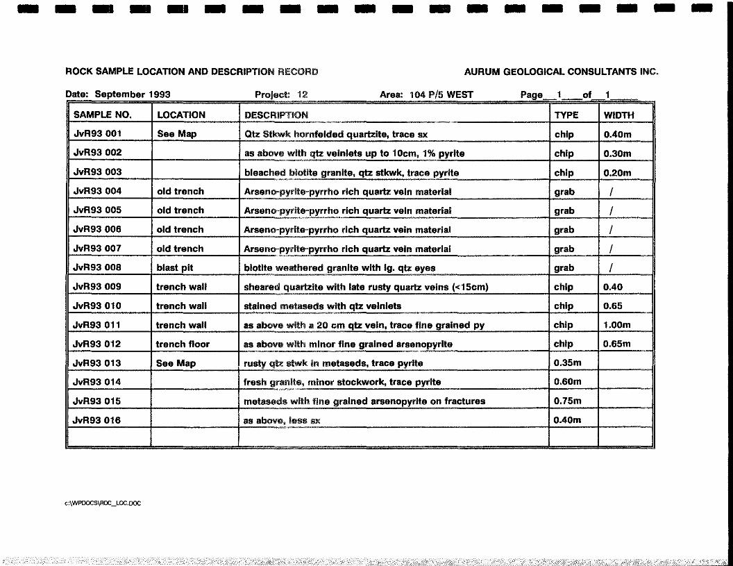
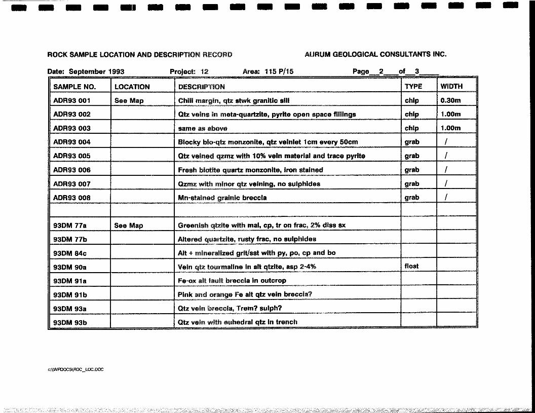
ROCK SAMPLE LOCATION AND DESCRIP11ON RECORD AIJRUM GEOLOGICAL CONSULTANTS INC.
Date: September 1993 Project: 12 Area: 104 P15 WEST Page_1__of_1~
SAMPLE NO. LOCATION DESCRIPTION TYPE WIDTH
JvR93 001 See Map Qtz Stkwk hornfeided quartzite, trace ax chip O.40m
JvR93 002 as above with qtz veiniets up to 10cm, 1% pyrite chip 0.30m
JvR93 003 bleached biotite granite, qtz stkwk, trace pyrite chip 0.20m
JvR93 004 old trench Arseno~pyrite~pyrrhorich quartz vein material grab IJvR93 005 old trench Arseno-pyrite~pyrrho rich quartz vein material grab IJvR93 006 old trench Arseno-pyrite-pyrrho rich quartz vein material grab IJvR93 007 old trench Arseno-pyrite~pyrrho rich quartz vein material grab IJvR93 008 blast pit biotite weathered granite with 1g. qtz eyes grab I
JvR93 009 trench wail sheared quartzite with late rusty quartz veins (<15cm) chip 0.40
JvR93 010 trench wail stained metaseds with qtz veinlets chip 0.65
JvR93 011 trench wail as above with a 20 cm qtz vein, trace fine grained py chip 1 .OOm
JvR93 012 trench floor as above with minor fine grained arsenopyrite chip 0.65m
JvR93 013 See Map rusty qtz stwk in metaseds, trace pyrite 0.35m
JvR93 014 fresh granite, minor stockwork, trace pyrite 0.60m
JvR93 015 metaseda with fine grained arsenopyrite on fractures 0.75m
JvR93 016 as above, less ax 0,40m
c:\WPOOCS\ROQ.LOC.OOC
a e a a a a a a a = a a a = a a a a a
ROCK SAMPLE LOCATION AND DESCRIPTiON RECORD AURUM GEOLOGICAL CONSULTANTS INC.
Page2__of_3_____Date: September 1993 Project: 12 Area: 115 P/15
SAMPLE NO, LOCATION DESCRIPTION TYPE WIDTH
ADR93 001 See Map Chill margin, qtz stwk granitic sill chip 0.30m
ADR93 002 Qtz veins in meta-quartzite, pyrite open space fillings chip 1 .OOm
ADR93 003 same as above chip 1 .OOm
ADR93 004 Blocky blo-qtz monzonite, qtz velnlet 1cm every 50cm grab IADR93 005 Qtz veined qzmz with 10% veIn material and trace pyrite grab I
ADR93 006 Fresh blotite quartz monzonite, iron stained grab IADR93 007 Qzmz with minor qtz veining, no suiphldes grab IADR93 008 Mn-stained grainic breccla grab I
93DM 77a See Map G!eenish qtzite with mal, cp, tr on frac, 2% diss ax
93DM 77b Altered quartzite, rusty trac, no suiphides
93DM Mc Alt + mineralized grit/sst with py, po, op and bo
93DM 90a Vein qtz tourmaiine in alt qtzlte, asp 2-4% float
93DM 91a Fe-ox alt fault breccia in outcrop
93DM Sib Pink and orange Fe alt qtz vein breccla?
93DM 93a Ott vein breccia, Trem? sulph?
93DM 93b Ott vein with euhedral qtz in trench
c:\WPD0CS\R0C_L0c.D~
a a a a i — — — — a a a — — — a
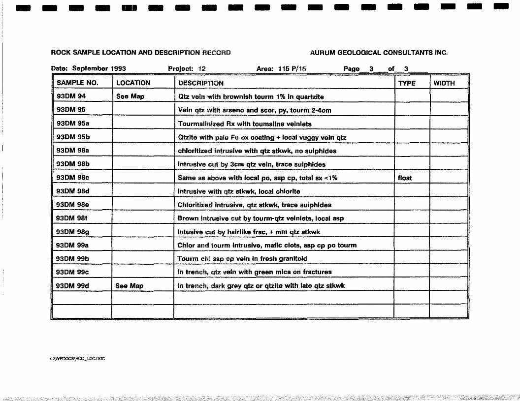
ROCK SAMPLE LOCATION AND DESCRIPTiON RECORD AURUM GEOLOGICAL CONSULTANTS INC.
Page_ft__of _3_____Date: September 1993 Project: 12 Area: 115 P115
SAMPLE NO. LOCATION DESCRIPTION TYPE WIDTH
93DM 94 See Map Qtz vein with brownish tourm 1% in quartzlte
93DM 95 Vein qtz with arseno and scor, py, tourm 2-4cm
93DM 95a Tourmaiinized Rx with toumaline veinlets
93DM 95b Otzite with pale Fe ox coating + iocal vuggy vein qtz
93DM 98a chioritized intrusive with qtz stkwk, no suiphides
93DM 98b intrusive cut by 3cm qtz vein, trace suiphides
93DM 98c Same as above with local po, asp cp, total ax <1% float
93DM 98d intrusive with qtz stkwk, iocai chlorite
93DM 98e Chioritized intrusive, qtz stkwk, trace suiphides
93DM 98f Brown intrusive cut by tourm-qtz velniets, local asp
93DM 98g intusive cut by hairlike frac, + mm qtz stkwk
93DM 99a Chior and tourm intrusive, mafic clots, asp cp p0 tourm
93DM 99b Tourm cM asp cp vein in fresh granitoid
93DM 99c In trench, qtz vein with green mica on fractures
93DM 99d See Map in trench, dark grey qtz or qtzite with late qtz stkwk
c:\WPOOCS~ROCWC.DOC
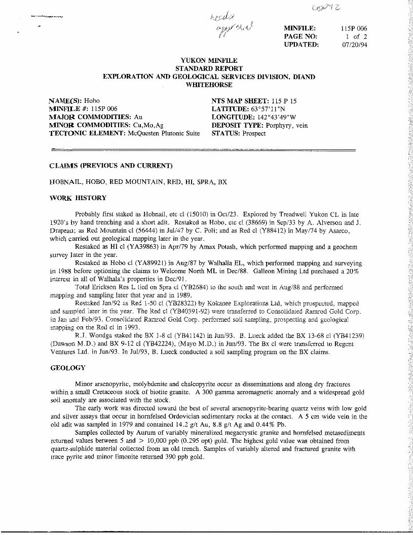
YUKON MINFILESTANDARD REPORT
EXPLORATION AND GEOLOGICAL SERVICESD1VISION, DIANDWIIITEHORSE
CLAIMS (PREVIOUS AND CURRENT)
HOBNAIL, HOBO, RED MOUNTAIN, RED, HI, SPRA,BX
WORK HISTORY
Probablyfirst stakedas Hobnail,etc ci (15010)in Oct/23. Exploredby Treadweli Yukon CL in late1920’s by handtrenchingand a short adit. Restakedas Hobo, etc ci (38669)in Sep/33by A. AlversonandJ.Drapeau;as RedMountainci (56444)in Jul/47by C. Poli; and as Red ci (Y88412)in May/74 by Asarco,whichcarriedout geologicalmappinglater in the year.
Restakedas HI ci (YA39863) in Apr/79 by Amax Potash,which performedmappinganda geochemsurvey laterin theyear.
Restakedas Hobo cI (YA89921) in Aug/87 by Walhalla EL, which performedmappingandsurveyingin 1988 beforeoptioningthe claims to WelcomeNorth ML in Dec/88. GalleonMining Ltd purchaseda 20%interest in all of Waihala’spropertiesin Dec/91.
Total EricksonRes L tied on Spraci (YB2684) to the southandwest in Aug/88 andperformedmappingandsamplinglaterthat year and in 1989.
RestakedJan/92as Red I-SO ci (YB28322)by KokaneeExplorationsLtd, which prospected,mappedandsampledlater in theyear. The Red ci (YB4039l-92)were transferredto ConsolidatedRamrodGold Corp.in Jan andFeb/93.ConsolidatedRamrodGold Corp. performedsoil sampling,prospectingandgeologicalmappingon the Red ci in 1993.
R.J.Wondgastakedthe BX 1-8 ci (YB4I 142) in Jun/93. B. Lueckaddedthe BX 13-68 cI (YB41239)(DawsonM.D.) and BX 9-12 cI (YB42224), (MayoM.D.) in Jun/93.The Bx ci were transferredto RegentVenturesLtd. in Jun/93. In Jul/93,B. Lueck conducteda soil samplingprogramon the BX claims.
GEOLOGY
Minor arsenopyrite,molybdeniteandchalcopyriteoccur as disseminationsandalongdry fractureswithin a small Cretaceousstock of biotite granite. A 300 gammaaeromagneticanomalyanda widespreadgoldsoil anomalyare associatedwith the stock.
The earlywork was directedtowardthe best of severalarsenopyrite-bearingquartzveinswith low goldandsilver assaysthat occur in homfelsedOrdoviciansedimentaryrocksat the contact. A 5 cm wide vein in theold adit was sampledin 1979 andcontained14.2 g/t Au, 8.8 g/t Ag and0.44% Pb.
Samplescollectedby Aurum of variablymineralizedmegacrysticgraniteandhornfelsedmetasedimentsreturnedvaluesbetween5 and > 10,000ppb (0.295opt) gold. The highestgoldvalue wasobtainedfromquartz-sulphidematerial collectedfrom an old trench, Samplesof variably alteredand fractured granitewithtracepyrite andminor limonite returned390 ppb gold.
(/f~MINFILE:PAGE NO:UPDATED:
I15P0061 of 2
07/20/94
NAME(S): HoboMIINFILE#: llSP 006MAJOR COMMODITIES: AuMINOR COMMODITIES: Cu,Mo,AgTECTONIC ELEMENT: McQuestenPlutonicSuite
NTS MAP SHEET: 115 P15LATITUDE: 63°57’ll”NLONGITUDE: 142°43’49”WDEPOSITTYPE: Porphyry,veinSTATUS: Prospect
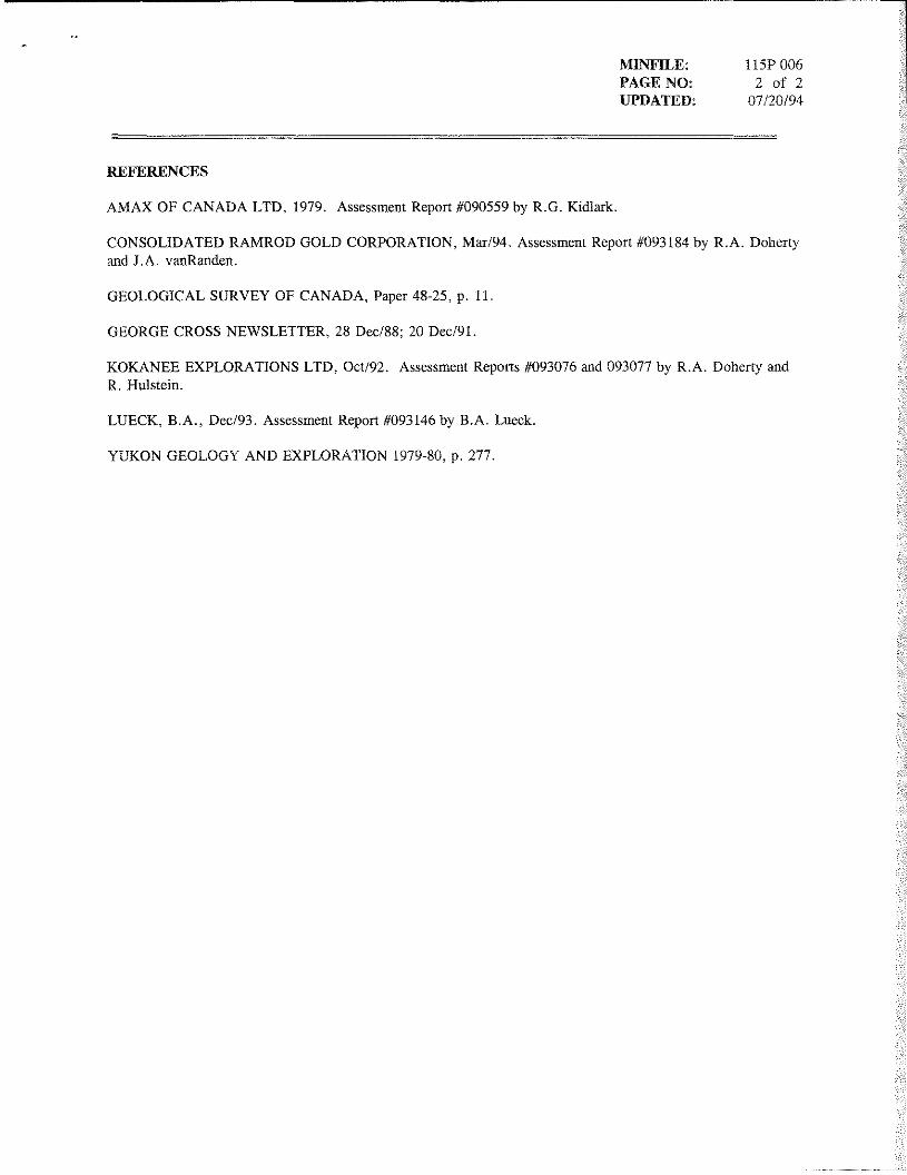
MINFILE: liSP 006PAGE NO: 2 of 2UPDATED 07/20/94
REFERENCES
AMAX OF CANADA LTD 1979 AssessmentReport#090559by R C Kidlark
CONSOLIDATED RAMROD GOLD CORPORATION,Mar/94 AssessmentReport#093184by R A DohertyandJ A vanRanden
GEOLOGICAL SURVEY OF CANADA Paper48-25 p 11
GEORGECROSSNEWSLETTER, 28 Dec/88 20 Dec/91
KOKANEE EXPLORATIONS LTD Oct/92 AssessmentReports#093076and093077by R A DohertyandR Hulstein
LUECK B A Dec/93 AssessmentReport#093146 by B A Lueck
YUKON GEOLOGY AND EXPLORATION 1979-80 p 277