Embed Size (px)
Citation preview
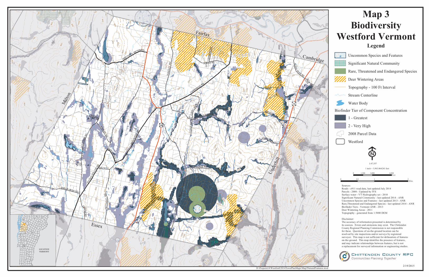
Map 3Biodiversity
Westford Vermont
Under
hill
Essex
Milton
Fairfax
Cambridge
Pond Brook
Rogers Brook
Roger
s Broo
k
Brown
s Rive
r Morgan
Brook
Beav
er Br
ook
rs15
rs128
WOODSHO
LLOW
RD
BROOK
S IDE RD
SEYMOUR RD
CAMBRIDGE RD
MACHIA HILL RD
COWIE RD
ROLLIN IRISH RD
CHAPINR D
S NOWH ILL LN
WESTFORD MILTON RD
ROGERSRDBI LL
COO K RD
PHELPS RD
COVE
YRD
S
LEAR
N ED
D R
MAPLE TREELN
MANLEYRD
PLAINS RD
OSGO
ODHI
LLRD
OLD
STAG
E RD
C OVE
Y RDN
ALLENIRISH RDHU
NTLE
YR D
OLD NUMBER ELEVEN RD
PET T
I NGI
LLRD
500
800
700
1000
1800170
0150014
001200110
016
00
1300
1000900800700600
500
500
1400
1300
1200
900
500 400
1200
110010
00
100090014
00
1300
1100
1200
1100
900
1000800
700
1300
800
700
1200
1100
1100
1200
1100
1000
600
700
1000
600
500
400
500
800
1100
1000
900
600
1300
1200
900
800 700 600
800
1400
1500
1000900
500
500
800
600
500
700
500
900
1000
1100
1200600
700800
9001000
1100
600
700
900
700
900
900
1300
700
1300
1200
1100
1100
800
400
500
900
900
600
1000
1000
900
700
800
500
1000
600
600
1100
700
800
900150040
0
900
1200
70090
0
1100
800
500
1200
700
15001400
600
1200
1100
800
900
900
700
1000
900
800
700
600
500
700
900
1000
800
800
700
700
900
600
LegendUncommon Species and Features
DDDDDDDDDDDDDDDDDDDDDDDDDDDDDDDDDDDDDDDDDDDDDDDDDDDDDDDDDDDDDDDDDDDDDD
Significant Natural CommunityRare, Threatened and Endangered SpeciesDeer Wintering AreasTopography - 100 Ft IntervalStream CenterlineWater Body
Biofinder Tier of Component Concentration1 - Greatest2 - Very High2008 Parcel DataWestford
E0 3,000 6,0001,500
Feet
1 inch = 3,963.064241 feet1:47,557
0 1 20.5Miles
Sources:Roads - e911 road data, last updated July 2014Parcels - 2008 - Updated by IVSSurface water - VT Hydrography set - 2010Significant Natural Community - last updated 2014 - ANRUncommon Species and Features - last updated 2013 - ANRRare,Threatened and Endangered Species - last updated 2014 - ANRBiofinder Tiers - Vermont ANR - 2013Deer Wintering Areas - 2011Topography - generated from 1:5000 DEM
Disclaimer:The accuracy of information presented is determined by its sources. Errors and omissions may exist. The Chittenden County Regional Planning Commission is not responsible for these. Questions of on-the-ground location can be resolved by site inspections and/or surveys by registered surveyor. This map is not sufficient for delineation of features on-the-ground. This map identifies the presence of features, and may indicate relationships between features, but is nota replacement for surveyed information or engineering studies.
LOCATIONVERMONT
2/19/2015 D:\Projects14\Westford\2014TownPlanMaps\Map3NaturalFeatures.mxd