Embed Size (px)
Citation preview
Department of the Interior
Bureau of Land Management
Washington, D.C. 20240
Manual 8400 - Visual Resource Management 04/05/1984
Table of Contents
.01 Purpose
.02 Objectives
.03 Authority
.04 Responsibility
.05 References
.06 Policy
.07 Overview of Visual Resource Management System
Glossary of Terms
Illustrations
1. Visual Resource Management System for BLM
Bibliography
Rel. 8-24 4/5/84
.01 Purpose. This section describes the overall policy direction for Visual Resource
Management (VRM) in the Bureau of Land Management (BLM).
.02 Objectives. The objective of Visual Resource Management is to manage public lands
in a manner which will protect the quality of the scenic (visual) values of these lands.
.03 Authority.
A. Federal Land Policy and Management Act of 1976, 43 U.S.C. 1701 et. seq.;
1. Section 102 (a)(8). States that “...the public lands be managed in a manner that
will protect the quality of the...scenic...values....”
2. Section 103 (c). Identifies “scenic values” as one of the resources for which
public land should be managed.
3. Section 201 (a). States that “The Secretary shall prepare and maintain on a
continuing basis an inventory of all public lands and their resources and other
values (including...scenic values)....”
4. Section 505 (a). Requires that “Each right-of-way shall contain terms and
conditions which will... minimize damage to the scenic and esthetic values....”
B. National Environmental Policy Act of 1969, 43 U.S.C. 4321 et. seq.;
1. Section 101 (b). Requires measures be taken to “ ...assure for all
American...esthetically pleasing surroundings....”
2. Section 102. Requires agencies to “Utilize a systematic, interdisciplinary
approach which will ensure the integrated use of...Environmental Design Arts in
the planning and decisionmaking....”
C. Surface Mining Control and Reclamation Act of 1977, 30 U.S.C. 1201 et. seq.;
1. Section 102 (d). Requires that measures be taken to “ ...assure that surface coal
mining operations are so conducted as to protect the environment.”
.04 Responsibility.
A. Director:
1. Lead responsibility for VRM functions in the Bureau is assigned to the
Recreation program. This includes the development of policy, guidelines,
training, and overall coordination.
Rel. 8-24 4/5/84
2. Each program (i.e., Range, Forestry, Minerals, Lands, etc.) involved in resource
development work is responsible for protecting visual values. This includes
ensuring that (1) personnel in each program who are involved in activities which
affect visual values are properly trained in visual management techniques; (2)
visual values are adequately considered in all management activities; and (3)
adequate guidance and funding is available to accomplish these purposes.
B. State Director:
1. Implements BLM policy and provides statewide program coordination and
guidance for managing visual resources on public lands.
2. Provides a statewide VRM training program to maintain skill levels for
personnel involved in activities which affect visual values.
3. Assigns the coordination of VRM within the State to one person and ensures
that the person is properly trained.
4. Maintains at least one person within the State who has the capability and
expertise to provide visual design assistance on major projects and to conduct
VRM training.
C. District Manager:
1. Provides Districtwide program coordination and guidance for managing visual
resources on public lands.
2. Ensures that all District personnel involved in management activities which
affect visual values are properly trained in visual management techniques.
3. Provides technical assistance to Resource Area Offices on visual management
applications.
4. Designates one person within the District to coordinate the VRM functions and
ensures that the person is properly trained.
D. Area Manager:
1. Prepares and maintains on a continuing basis an inventory of visual values on
public lands and ensures that these values are adequately considered in the land-
use planning and decisionmaking processes.
2. Ensures that visual impacts are minimized in all resource development
activities including non-BLM initiated projects.
Rel. 8-24 4/5/84
3. Assigns the coordination of VRM to one person and ensures that the person is
properly trained.
4. Ensures that all Resource Area personnel involved in surface disturbing
activities are trained in VRM techniques. Back to Top
.05 References.
A. BLM Manual 8410.
B. BLM Manual 8431.
.06 Policy.
A. The Bureau has a basic stewardship responsibility to identify and protect visual values
on public lands. The basic policy parameters for accomplishing this task are as follows:
1. The Bureau shall prepare and maintain on a continuing basis an inventory of
visual values on all public lands. Priority for new inventory shall be given to those
areas where it is needed for issue resolution in Resource Management Planning
(RMP) or in those areas where a project is proposed and an inventory does not
exist or needs updating. The goal is to have a completed VRM inventory for each
RMP effort. The level of detail should vary with the relative value of the visual
resources within the planning area.
2. Visual management objectives (classes) are developed through the RMP
process for all Bureau lands. The approved VRM objectives shall result from, and
conform with, the resource allocation decisions made in RMP’s.
3. Interim visual management objectives are established where a project is
proposed and there are no RMP, or Management Framework Plan (MFP)
approved VRM objectives. These objectives are developed using the guidelines in
Manual Section 8410 and must conform with the land use allocations set forth in
the RMP which covers the project area. The establishment of interim VRM
objectives will not require a plan amendment unless the project itself requires one.
4. The approved VRM objectives (classes) provide the visual management
standards for the design and development of future projects and for rehabilitation
of existing projects.
5. Visual design considerations shall be incorporated into all surface disturbing
projects regardless of size or potential impact. Emphasis shall be placed on
providing these inputs during the initial planning and design phase so as to
minimize costly redesign and mitigation at later phases of project design and
Rel. 8-24 4/5/84
development. Ensuring early visual design inputs into non-Bureau initiated
projects in many cases is beyond Bureau control. However, every effort should be
made to inform potential applicants of the visual management objectives so they
can adequately incorporate visual design considerations into their initial planning
and design efforts.
6. The contrast rating process (Manual Section 8431) is used as a visual design
tool in project design and as a project assessment tool during environmental
review. Contrast ratings are required for proposed projects in highly sensitive
areas or high impact projects, but may also be used for other projects where it
would appear to be the most effective design or assessment tool. A brief narrative
visual assessment is completed for all other projects which require an
environmental assessment or environmental impact statement.
7. Ensure that project monitoring efforts include timely and thorough compliance
evaluations, especially during the construction phase, to ensure that visual
management provisions are effectively carried out.
B. Visual Resource Management is a management responsibility shared by all resource
programs (Section .04A.2).
C. VRM training shall be conducted in each District and Resource Area to maintain skill
levels for VRM coordinators and project coordinators. Emphasis shall be placed on
improving design skills so that visual design considerations will be incorporated into all
project proposals beginning with initial planning and design.
.07 Overview of Visual Resource Management System.
A. The VRM System. Public lands have a variety of visual values. These different values
warrant different levels of management. Because it is neither desirable nor practical to
provide the same level of management for all visual resources, it is necessary to
systematically identify and evaluate these values (Illustration 1) to determine the
appropriate level of management. Visual values are identified through the VRM
inventory (Manual Section 8410) and are considered with other resource values in the
Resource Management Planning (RMP) process. Visual management objectives are
established in RMP’s in conformance with the land use allocations made in the plan.
These area specific objectives provide the standards for planning, designing, and
evaluating future management projects.
The contrast rating system (Manual Section 8431) provides a systematic means to
evaluate proposed projects and determine whether these projects conform with the
approved VRM objectives. It also provides a means to identify mitigating measures that
can be taken to minimize adverse visual impacts. The VRM system, therefore, provides a
means: to identify visual values; to establish objectives through the RMP process for
managing these values; and to provide timely inputs into proposed surface disturbing
projects to ensure that these objectives are met.
Rel. 8-24 4/5/84
B. Use of Basic Landscape Design Principles. Assigning values to visual resources is a
subjective process. The phrase, “beauty is in the eye of the beholder,” is often quoted to
emphasize the subjectivity in determining scenic values. Yet, researchers have found
consistent levels of agreement among individuals asked to evaluate visual quality.
Designers have used the basic design elements of form, line, color, and texture to
describe and evaluate landscapes for hundreds of years. Modifications in a landscape
which repeat the landscape’s basic elements are said to be in harmony with their
surroundings. Modifications which do not harmonize often look out of place and are said
to contrast or stand out in unpleasing ways. These basic design elements and concepts
have been incorporated into the VRM system to lend objectivity, integrity, and
consistency to the process. The VRM system is designed to separate the existing
landscape and the proposed project into their features and elements and to compare each
part against the other in order to identify those parts which are not in harmony. Then,
ways are sought to bring them back into harmony. An understanding of basic design
principles and how they relate to the appearance of projects is essential in order to
minimize visual impacts. The references listed in the Bibliography provide source
information on environmental design concepts and techniques and their application in
minimizing visual impacts. The information generated through the VRM system is to be
used as a guide. The decision on the amount of visual change that is acceptable is made
by the field manager.
Rel. 8-24 4/5/84
Glossary of Terms
- A -
(a)esthetics: relates to the pleasurable characteristics of a physical environment as
perceived through the five senses of sight, sound, smell, taste, and touch.
adverse visual impact: any modification in land forms, water bodies, or vegetation, or
any introduction of structures, which negatively interrupts the visual character of the
landscape and disrupts the harmony of the basic elements (i.e., form, line, color, and
texture).
angle of observation: the angle, both vertical and horizontal, between a viewer’s line of
sight and the landscape being viewed.
areas of critical environmental concern (ACEC’s) for scenic values: areas within the
public lands where special management attention is required to protect or prevent
irreparable damage to important scenic values.
- B -
background distance zone: the visible area of a landscape which lies beyond the
foreground middleground. Usually from a minimum of 3 to 5 miles to a maximum of
about 15 miles from a travel route, use area, or other observer point. Atmospheric
conditions in some areas may limit the maximum to about 8 miles or less.
basic elements: the four design elements (form, line, color, and texture) which determine
how the character of a landscape is perceived.
- C -
characteristic: a distinguishing trait, feature, or quality.
characteristic landscape: the established landscape within an area being viewed. This
does not necessarily mean a naturalistic character. It could refer to an agricultural setting,
an urban landscape, a primarily natural environment, or a combination of these types.
computer graphics: visual displays of information produced by an electronic computer.
This includes both hard-copy and screen displays.
contrast: opposition or unlikeness of different forms, lines, colors, or textures in a
landscape.
contrast rating: a method of analyzing the potential visual impacts of proposed
management activities.
Rel. 8-24 4/5/84
cultural modification: any man-caused change in the land form, water form, vegetation,
or the addition of a structure which creates a visual contrast in the basic elements (form,
line, color, texture) of the naturalistic character of a landscape.
- D -
distance zones: a subdivision of the landscape as viewed from an observer position. The
subdivision (zones) includes foreground-middleground, background, and seldom seen.
- E -
easement, scenic: a right to make use of land to protect the scenic values.
enhancement: a management action designed to improve visual quality.
- F -
foreground-middleground distance zones: the area visible from a travel route, use area,
or other observation point to a distance of 3 to 5 miles. The outer boundary of this zone is
defined as the point where the texture and form of individual plants are no longer
apparent in the landscape. Vegetation is apparent only in patterns or outline.
form: the mass or shape of an object or objects which appear unified, such as a
vegetative opening in a forest, a cliff formation, or a water tank.
- H -
harmony: a combination of parts into a pleasing or orderly whole: congruity; a state of
agreement of proportionate arrangement of form, line, color, and texture.
- I -
interdisciplinary team: a group of individuals with different training, representing the
physical sciences, social sciences, and environmental design arts, assembled to solve a
problem or perform a task. The members of the team proceed to a solution with frequent
interaction so that each discipline may provide insights to any stage of the problem and
disciplines may combine to provide new solutions.
- K -
key observation point (KOP): one or a series of points on a travel route or at a use area
or a potential use area, where the view of a management activity would be most
revealing.
Rel. 8-24 4/5/84
- L -
landscape character: the arrangement of a particular landscape as formed by the variety
and intensity of the landscape features and the four basic elements of form, line, color,
and texture. These factors give the area a distinctive quality which distinguishes it from
its immediate surroundings.
landscape features: the land and water form, vegetation, and structures which compose
the characteristic landscape.
lighting:
back lighting: a situation where the light source is coming from behind the object being
viewed. Objects are generally in shadow with highlighted edge
front lighting: a situation where the light source is coming from behind the observer and
shining directly upon the area being viewed.
side lighting: a situation where the light source is coming from the side of a scene or
object being viewed. It is usually the most critical for revealing contrast.
line: the path, real or imagined, that the eye follows when perceiving abrupt differences
in form, color, or texture. Within landscapes, lines may be found as ridges, skylines,
structures, changes in vegetative types, or individual trees and branches.
- M -
management activity: a surface disturbing activity undertaken on the landscape for the
purpose of harvesting, traversing, transporting, protecting, changing, replenishing, or
otherwise using resources.
mitigation measures: methods or procedures designed to reduce or lessen the adverse
impacts caused by management activities.
multidisciplinary team: a group specialists with different backgrounds, assembled to
solve a problem. The problem is broken into pieces and each specialist works on a
portion of the problem. Partial solutions are then linked together to provide the final
solutions.
- N -
naturalistic character: a landscape setting where the basic elements are displayed in a
composition that appears unaltered by man.
Rel. 8-24 4/5/84
- O -
observer position: the placement and relationship of a viewer to the landscape which is
being viewed.
- P -
photomontage: the technique of combining in a single photographic composition, parts
of different photographs by superimposition.
physiographic province: an extensive portion of the landscape normally encompassing
many hundreds of square miles, which portrays similar qualities of soil, rock, slope, and
vegetation of the same geomorphic origin (Fenneman 1946, Sahrhaftig 1975).
- R -
rehabilitation: a management alternative and/or practice which restores landscapes to a
desired scenic quality.
- S -
scale: the proportionate size relationship between an object and the surroundings in
which the object is placed.
scenery: the aggregate of features that give character to a landscape.
scenic area: an area whose landscape character exhibits a high degree of variety and
harmony among the basic elements which results in a pleasant landscape to view.
scenic quality: the relative worth of a landscape from a visual perception point of view.
scenic quality evaluation key factors: the seven factors (land form, vegetation, water,
color, adjacent scenery, scarcity, and cultural modifications) used to evaluate the scenic
quality of a landscape.
scenic quality ratings: the relative scenic quality (A, B, or C) assigned a landscape by
applying the scenic quality evaluation key factors; scenic quality A being the highest
rating, B a moderate rating, and C the lowest rating.
scenic quality rating unit: a portion of the landscape which displays primarily
homogenous visual characteristics of the basic landscape features (land and water form,
vegetation, and structures).
scenic values: (refer to scenic quality and scenic quality ratings).
Rel. 8-24 4/5/84
seen area: that portion of the landscape which is visible from roads, trails, rivers,
campgrounds, communities, or other key observation positions.
seldom seen distance zone: portions of the landscape which are generally not visible
from key observation points, or portions which are visible but more than 15 miles
distance.
sensitivity levels: measures (e.g., high, medium, and low) of public concern for the
maintenance of scenic quality.
simulation: a realistic visual portrayal which demonstrates the perceivable changes in
landscape features caused by a proposed management activity. This is done through the
use of photography, artwork, computer graphics, and other such techniques.
- T -
texture: the visual manifestations of the interplay of light and shadow created by the
variations in the surface of an object or landscape.
- U -
use volume: the total volume of visitor use each segment of a travel route or use area
receives.
- V -
variables: factors influencing visual perception including distance, angle of observation,
time, size or scale, season of the year, light, and atmospheric conditions.
variety: the state or quality of being varied and having the absence of monotony or
sameness.
viewshed: the landscape that can be directly seen under favorable atmospheric
conditions, from a viewpoint or along a transportation corridor.
visual contrast: (see contrast).
visual quality: (see scenic quality).
visual resources: the visible physical features on a landscape (e.g., land, water,
vegetation, animals, structures, and other features).
visual resource management classes: categories assigned to public lands based on
scenic quality, sensitivity level, and distance zones. There are four classes. Each class has
an objective which prescribes the amount of change allowed in the characteristic
landscape.
Rel. 8-24 4/5/84

visual resource management (VRM): the inventory and planning actions taken to
identify visual values and to establish objectives for managing those values; and the
management actions taken to achieve the visual management objectives.
visual values: (see scenic quality).
Rel. 8-24 4/5/84
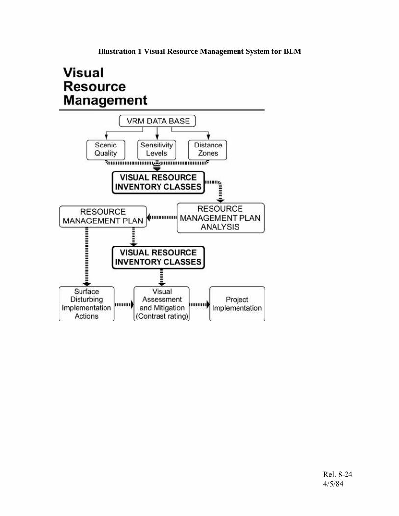
Illustration 1 Visual Resource Management System for BLM
Rel. 8-24 4/5/84
Bibliography
BOOKS
Appleyard, Donald; Lynch, Kevin; and Meyer, John R. The View from the Road. M.I.T.
Press, Cambridge; 1964.
Litton, R. B. Jr. Aesthetic Demension of the Landscape. University Press, 1972.
McHarg, Ian L. Design with Nature. The Natural History Press, Garden City, The Natural
History Press, Garden City, New York; 1969.
Rutledge, Albert J. Anatomy of a Park. McGraw Hill Book Company, New York; 1971.
Simonds, John O. Earthscape. McGraw Hill Book Company, New York; 1978.
Simonds, John O. Landscape Architecture. F.W. Dodge Corporation, New York; 1961.
MAGAZINES
Landscape Architecture. Louisville: The Publication Board of the American Society of
Landscape Architects, published bi-monthly.
Landscape Journal. Madison: The University of Wisconsin Press, published twice yearly.
GOVERNMENT PUBLICATIONS
USDA FOREST SERVICE
Descriptive Approaches to Landscape Analysis: (R.B. Litton, Jr.), 1979.
Forest Landscape Description and Inventories; A Basis for Land Planning and Design:
(R. B. Litton, Jr.) Research Paper Number PS W-49, 1968.
Landscape Control Points; A Procedure for Predicting and Monitoring Visual Impacts:
(R.B. Litton, Jr.) General Technical Report Number PSW-91, 1973.
National Forest Landscape Management, Volume 1: (Agriculture Handbook 434). U.S.
Government Printing Office, Washington, D.C.; 1973.
National Forest Landscape Management, Volume 2, Chapter 1, The Visual Management
System: (Agriculture Handbook 462). U.S. Government Printing Office, Washington,
D.C.; 1974.
Rel. 8-24 4/5/84
National Forest Landscape Management, Volume 2, Chapter 2, Utilities: (Agriculture
Handbook 478). U.S. Government Printing Office, Washington, D.C.; 1975.
National Forest Landscape Management, Volume 2, Chapter 3, Range: (Agriculture
Handbook 484). U.S. Government Printing Office, Washington, D.C.; 1977.
National Forest Landscape Management, Volume 2, Chapter 4, Roads: (Agriculture
Handbook 483). U.S. Government Printing Office, Washington, D.C.; 1977.
National Forest Landscape Management, Volume 2, Chapter 5, Timber: (Agriculture
Handbook 559). U.S. Government Printing Office, Washington, D.C.; 1980.
Our National Landscape - Annotated Bibliography and Expertise Index: Special
Publication 3279. Berkeley: Pacific Southwest Forest and Range Experiment Station,
1981.
Proceedings of Our National Landscape: A Conference on Applied Techniques for
Analysis and Management of the Visual Resource (General Technical Report PSW-35).
Berkeley: Pacific Southwest Forest and Range Experiment Station, 1979.
USDI BUREAU OF LAND MANAGEMENT
Visual Resource Management Program. U.S. Government Printing Office, Washington,
D.C.; 1980.
Visual Simulation Techniques. U.S. Government Printing Office, Washington, D.C.;
1980.
Rel. 8-24 4/5/84