Embed Size (px)
Citation preview


MANDATE, MISSION AND VISION
MANDATE
The Mines and Geosciences Bureau is the primary government agency under
Department of Environment and Natural Resources (DENR) responsible for the
conservation, management, development and proper use of the country’s mineral
resources including those in reservations and lands of public domain. In pursuing the
mandate, it envisions a mining and minerals industry that is not only prosperous but
also socially, economically and environmentally sustainable, with broad community
and political support while positively and progressively assisting in the government’s
program on revitalizing the minerals industry and contribution to the general
economic well-being of the nation.
MISSION
The MGB, as steward of the country's mineral resources, is committed to the
promotion of sustainable mineral resources development, aware of its contribution
to national economic growth and countryside community development. It fully
recognizes that the development of a responsive policy framework in partnership
with stakeholders to govern mineral exploration, mining and investment decisions
and an effective institutional structure, are fundamental requisites for the sustainable
utilization of the country's mineral resources. It is adherent to the promotion of
geological studies as an integral element of socio-economic development,
environmental protection and human safety. Yet, it is sensitive to the known
environmental impacts of mining and the need for restoration and rehabilitation of
mining affected areas and the development and adoption of environmental and
geo-scientific technologies.
VISION
MGB envisions a minerals industry that is not only prosperous but also socially,
economically and environmentally sustainable, with broad community and political
support while positively and progressively assisting in government’s program on
poverty alleviation and contributing to the general economic well-being of the
nation. MGB also aims to be the leading geoscience and geo-resources Bureau
serving the public and nation with scientific reliability.

FUNCTIONAL STATEMENT
MINES AND GEOSCIENCES BUREAU REGIONAL OFFICE NO. I
OFFICE OF THE REGIONAL DIRECTOR
The Office of Regional Director shall implement the pertinent laws, policies, rules and
regulations and programs; exercise the management functions of planning,
organizing, directing and controlling; undertake Information, Education and
Communication campaign; and perform such other duties and functions as may be
provided by law or delegated by the Director.
FINANCE AND ADMINISTRATIVE DIVISION
The Finance and Administrative Division (FAD) shall provide general administrative
services pertaining to human and financial resources and property and records
management.
GEOSCIENCES DIVISION
The Geosciences Division (GSD) shall undertake land and marine geoscientific
surveys including mineral exploration, geological mapping, geohazard assessment,
groundwater resource exploration and vulnerability assessment, and engineering
geological and geoenvironmental studies and provide geological laboratory and
information services.
MINE MANAGEMENT DIVISION
The Mine Management Division (MMD) shall undertake initial evaluation of mining
and mining-related applications, monitoring of the disposition and utilization of
mineral lands and resources, and survey of mineral lands.
MINE SAFETY, ENVIRONMENT AND SOCIAL DEVELOPMENT DIVISION
The Mine Safety, Environment and Social Development Division (MSESDD) shall
conduct the evaluation and monitoring of implementation of programs and
investigate incidents/complaints on mine safety and health, environmental
management and social development.

We, at the Mines and Geosciences Bureau Region 1 want to ensure sustainability
not just for the present but most importantly for the future generations. We strongly
support our Environmental Secretary Roy A. Cimatu in strengthening environmental,
social and economic reforms in the mining sector.
Therefore, this 2018, we have been constantly conducting activities and events
for our intensified environmental protection and conservation. Early this year, Sec.
Cimatu has announced DENR’s priority programs which are geared towards the
attainment of clean air, clean water,solid waste management, geo-hazard, groundwater
assessment and responsible mining, forest and watershed management, intensified
forest protection and anti-illegal logging, enhanced biodiversity conservation, scaling
up of coastal and marine ecosystems, improved land administration and management
and coastal clean-up.
And to strengthen the enforcement of mining and environmental laws in the
community and provincial level, MGB I deployed four (4) personnel to the Provincial
Environment and Natural Resources Offices in the Ilocos Region. The said personnel
shall be the bureau’s counterpart on mining and geological concerns in the community
and provincial offices of the DENR. Further, the public shall have easy access to the
bureau’s frontline services to sustain efforts towards responsible mining and disaster-
resilient communities.
We have also supported Tayo ang Kalikasan which is inclined with the bureau’s
vision of a minerals industry that is not only prosperous but also socially, economically
and environmentally sustainable, and progressively assisting in the government’s
program on poverty alleviation and contributing to the general economic well-being of
the nation. This program is a citizen’s movement towards environmental stewardship
and sustainable development, engaging the citizenry’s active participation in
environmental protection and conservation.
The year is not yet over. Much has still to be accomplished and attained. Yet, we
are positive on making progress and bringing good news. And most especially, we can
overcome challenges.
We are pro-people, pro-development and pro-environment mining.
CARLOS A. TAYAG
OIC, Regional Director

GENERAL MANAGEMENT AND SUPPORT SERVICE
FINANCE AND ADMINISTRATIVE DIVISION (FAD)
ADMINISTRATIVE SECTION
The Region has fully complied with all the requirements of the conditions of
Good Governance by posting the Transparency Seal on the MGB-I Regional
Website which consists of the mandate and function of the Office, List of
personnel, approved Work and Financial Plan, Annual Procurement Plan and
PHILGEPS certification; the Citizens’ Charter and each divisions SECSIME were
also posted in a conspicuous area in the office;
The Human Resource and Management Service maintains records of 37
permanent, 5 Co-Terminus with the Incumbent (CTI) and 25 Contract of
Services.
Various trainings were coordinated, attended/ conducted for bettering the
performance, gaining more knowledge of individuals and sharpening their skills.
All plantilla personnel submitted their respective Statement of Assets, Liabilities
and Networth (SALN) for CY 2017 in compliance to Section 8 of Republic Act
No. 6713 otherwise known as “Code of Conduct and Ethical Standards for
Public Officials and Employees”, updated Personal Data Sheet (PDS), Individual
Performance Commitments Review (IPCR), among other as required by the
Civil Service Commission.
FINANCE SECTION
The Department of Budget and Management (DBM), through the General
Appropriations Act (GAA) has released P51,343,000.00 budget for CY 2018,
P28,109,000.00 for Personnel Services (PS) and P23,234,000.00 for Maintenance
and Other Operating Expenses (MOOE). Personnel Services (PS) has
P1,177,000.00 for Administration of Personnel Benefit (Terminal Leave Benefit) of
Ms. Natividad Fabella, Mining Claims Examiner III who will be retiring on
December 25, 2018. Additional budget for Other Professional Services
amounting P513,108.36 Maintenance and Other Operating Expenses (MOOE)
was released by MGB Central Office, for the Integration of MGB Programs and
staff to PENROs and CENROs. An allotment of P1,000,000.00 budget was
granted for the conduct of National Mineral Reservation Program under SAGF
Fund338. Thus, the total allotment as of June 30, 2018 amounted to
P52,856,108.36.
As of June 30, 2018, Budget Utilization Rate (BUR 1) (Obligation/Allotment) for
MOOE have reached 48%, Obligation of P24,784,613.87. Budget Utilization Rate
(BUR 2) (Disbursement/Obligation) reached 97%, Disbursement of
P24,426,633.90. A new Budget Utilization Rate (BUR 3) (Disbursement/Cash
Allocation) to measure financial performance of an operating unit was
introduced by DBM. As of June 30, 2018, Budget Utilization Rate (BUR 3)
(Disbursement/Cash Allocation) reached 100%, Cash Allocation of
P24,429,063.39 for the 1st semester.
All advances to special disbursing officers and employees were liquidated and
aging of cash advances was verified by Commission on Audit (COA).
An orientation on the Proper Liquidation of Cash Advances of Special
Disbursing Officers (SDOs) was conducted by the Mines and Geosciences

Bureau I-Finance and Administrative Division last May 15, 2018 at the Max’s
Restaurant in San Fernando City, La Union. This aimed to properly guide the
SDOs on the processes and emphasize on the importance of accomplishing
timely liquidation reports equipped with the required supporting documents
and attachments. This is in line with the Commission on Audit rule that cash
advances must be liquidated within the prescribed periods depending upon
the nature and purpose of the particular cash advance. as provided under
COA Circular No. 97-002 dated February 10, 1997, restating with amendments
(the rules and regulations on the granting, utilization and liquidation of cash
advances).
Also, it served as a venue to achieve improvements in accountability and
government performance by combining transparency with participation and
collaboration, through partnerships to lay down the true cost and benefit of
government activities.
Chief Geologist Mr. Socrates Gaerlan discussing issues
and concerns of SDOs with Accountant III Ms. Haydee
Ofiaza

Budget and Financial Accountability Reports (BFARs) were submitted
accurately and timely to MGB Central Office, COA and DBM. Budget
Proposals, Cash Programs, Monthly and Quarterly Financial Reports were all
prepared and submitted. Likewise, activities such as processing of vouchers
and payrolls, reports preparation, and other related financial matters were
100% accomplished.
PLANNING MANAGEMENT SERVICES
Monthly Physical Accomplishment Reports, Performance Information Report
and Fund Utilization Reports were regularly submitted to MGB Central Office.
To improve the reporting of accomplishments of every Division as well as
records filing and keeping, planning coordinators were designated in the
respective divisions to effectively coordinate with the planning officer for the
timely submission of reports.
Periodic assessment of accomplishments vis-à-vis target is conducted and
timely feedbacks are provided to the division concern for immediate and
appropriate course of action.

On May 28 to June 1, 2018, Mr. Ralph Vasquez and Ms. Marietta Tan of MGB-
CO Planning, Policy International Affairs Division (PPIAD) conducted the
validation of the 2017 accomplishments. The objective of the activity is to
validate the reported 2017 accomplishments; to determine actions taken on
the recommendations of the validation of 2016 accomplishments; and to
determine other concerns in the implementation of plans and programs.
Presentation of the Results of Validation.

001: NATURAL RESOURCES SUSTAINABLY MANAGED - PROGRAM 1: MINERAL
RESOURCES ENFORCEMENT AND REGULATORY PROGRAM
MINERAL INVESTMENT PROMOTION PROGRAM
Issuance of Mining Permits/Contracts
The Mining Tenement Evaluation Section (MTES) issued four (4) Industrial Sand
and Gravel (ISAG) Permits, a total of eighty (80) Ore Transport Permits, sixty-
five (65) Mineral Ore Export Permits (MOEP), and two (2) Certificates of
Accreditation.
Four (4) Certificate of Environmental Management and Community Relations
Record (CEMCRR) covering the application for renewal of MPP of Northwest
Luzon Mining Corporation, expansion of operations of Northern Cement
Corporation and ISAG renewal applications of San Hai Aggregates and
Construction Corporation and Felix P. Sanchez together with one (1)
Certificate of Exemption of the new ISAG application of Mark Bradley A.
Salcedo were issued.
Approval and issuance of Industrial Sand and Gravel Permits
(ISAG)

Use it or Lose It Policy
In compliance to the Department Memorandum Order No. 2010-04 “Reforms
in the Department Mining Tenement System”, which directs the Bureau to
expedite the grant of mining contracts and permits, cleanse and process all
pending mining applications and strengthen all compliance requirements,
the Office have issued four (4) Industrial Sand and Gravel Permit.
Tenement ID Tenement Holder Date Approved
92-002 (IPA-20) Conrado V. Ignacio January 23,2018
018-002(IPA000332) Matthew O. Liis February 6, 2018
96-001 (IPA-07) North Point Aggregates, Inc. May 7, 2018
IP 92-001 (IPA-19) IP-1-004-97 Benito Y. Co June 20, 2018
Field Validation on the application for Mineral Ore Export
Permit (MOEP)

Review of the Performance of Existing Mining Operations per EO No. 79
Approval of SHES Program
a) Environmental Protection and Enhancement Program (EPEP)
Four (4) Environmental Protection and Enhancement Program (EPEP) were
approved.
The approved EPEPs are for the ISAG permit renewal applications of William K.
Dy, Efhraim B. Balitao, Ignacio B. Balitao and Delia B. Dizon
b) Annual Environmental Protection and Enhancement Program/Care and
Maintenance Program (AEPEP/CMP)
The 2018 Annual Environmental Protection and Enhancement Programs
(AEPEP) of thirty five (35) contractors/permit holders involving seven (7) MPSA
contracts and twenty eight (28) ISAG permits including one (1) Care
and Maintenance Program were approved for the 1st Semester 2018.
c) Social Management and Development Program/Community Development
Program (SDMP/CDP)
The Section had evaluated and issued Certificate of Approval (CA) on five (5)
SDMP’s and two (2) CDP’s for a total of seven (7) Certificates of Approvals for
the period against the target of two (2) CA’s for 350% accomplishments. Very
high accomplishment was recorded because some of the Programs were
evaluated last year but undergone some rectification/revision and approved
only during the period in review.

d) Annual Social Development and Management Program (ASDMP) evaluation
and issuance of certificate of approval.
The Section had evaluated and issued Certificate of Approval (CA) on thirty
eight (38) ASDMP’s for the period against the target of eighteen (18) CA’s for
211% accomplishments. Very high accomplishment was recorded because
seventeen programs by Permit Holders operated by Omnico Natural
Resources, Inc. (ONRI) and other newly approved mining permits which are
not included in the universe had their ASDMP’s approved during the period in
review.
e) Annual Safety and Health Program (ASHP)
Thirty nine (39) ASHP’s were evaluated and approved for the 1st semester.
f) Environmental Work Program endorsed to MMD (EWP)
One (1) EnWP was endorsed to Mine Management Division for the renewal of
the Exploration Period of Cunickel Mining and Industrial Corporation.
g) National Greening Project
Two (2) Consolidated Quarterly National Greening Program (NGP) Reports
were submitted for the period in review. The said reports belonged to Holcim
Phils, Inc., Northern Cement Corporation and Heirs of Elias E. Olegario which
are holders of Mineral Production Sharing Agreement Contracts located in
Bacnotan, La Union and Agno, Pangasinan, Sison, Pangasinan and
Mangatarem, Pangasinan, respectively.
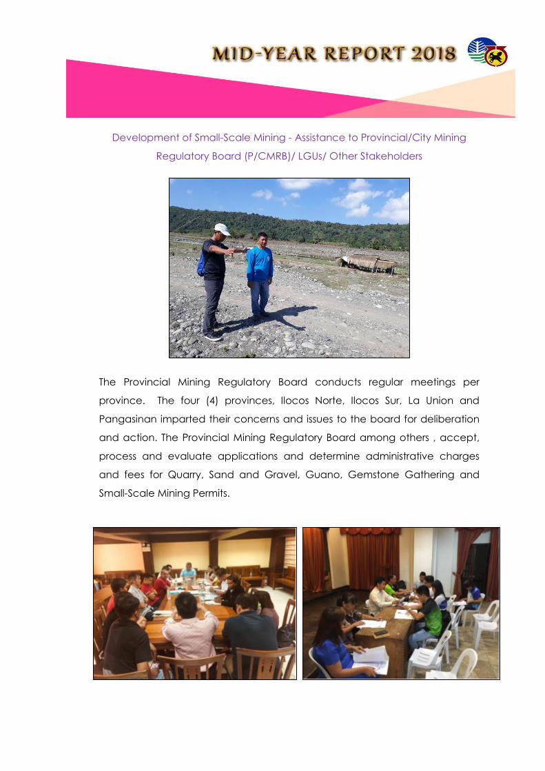
Development of Small-Scale Mining - Assistance to Provincial/City Mining
Regulatory Board (P/CMRB)/ LGUs/ Other Stakeholders
The Provincial Mining Regulatory Board conducts regular meetings per
province. The four (4) provinces, Ilocos Norte, Ilocos Sur, La Union and
Pangasinan imparted their concerns and issues to the board for deliberation
and action. The Provincial Mining Regulatory Board among others , accept,
process and evaluate applications and determine administrative charges
and fees for Quarry, Sand and Gravel, Guano, Gemstone Gathering and
Small-Scale Mining Permits.

MINING INDUSTRY AND DEVELOPMENT PROGRAM
Monitoring/Audit of Mining Permits/Contracts/Leases/Claims/JOAs (including those
within Mineral Reservations) as to compliance with the Terms and
Conditions/Requirements and implementation of approved Work Program/Safety,
Health, Environmental and Social Development Programs
a) Monitoring of Work Program
The Monitoring and Technical Services Section (MTSS) is primarily responsible
for validation of mineral reserves of mining operations, mineral statistical
analysis and monitoring of the disposition and utilization of mineral lands and
resources. It aims to monitor existing contracts and permits once a year to
ensure full compliance of the contractors, permittees and permit holder to
the terms and conditions of the approved mining contracts/permits, and
other applicable mining laws, rules and regulations. Compliance monitoring
also emphasizes on the implementation of the approved work program,
timely submission of reportorial requirements, attendance to fiscal obligations
and even employment equity. For the period in review, MTSS has audited a
total of sixteen (16) contracts and permits. These include eight (8) MPSA
Contracts, one (1) FTAA Contract, one (1) Mineral Processing Permit, and six
(6) Industrial Sand and Gravel Permits

One of the parameters being monitored is the implementation of the
work program particularly the mode of quarrying within the permit
area. As seen during the monitoring of the industrial sand and
gravel operation of R. J. Flores Construction along Naguilian River,
they are undertaking systematic quarrying wherein extraction starts
upstream and moving downstream.
Aside from quarrying, the other half of an industrial sand and gravel
operation is the processing of the extracted river aggregate
materials from the permit area. It was noted during monitoring of
the crushing operation of Engr. Felix P. Sanchez at Barangay Acao,
Bauang, La Union that he is compliant to the work program as far as
the establishment of a processing plant is concerned.
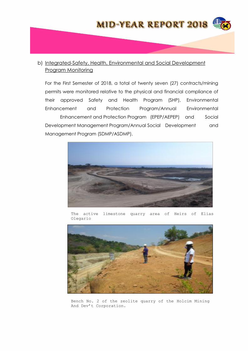
b) Integrated-Safety, Health, Environmental and Social Development
Program Monitoring
For the First Semester of 2018, a total of twenty seven (27) contracts/mining
permits were monitored relative to the physical and financial compliance of
their approved Safety and Health Program (SHP), Environmental
Enhancement and Protection Program/Annual Environmental
Enhancement and Protection Program (EPEP/AEPEP) and Social
Development Management Program/Annual Social Development and
Management Program (SDMP/ASDMP).
The active limestone quarry area of Heirs of Elias
Olegario
Bench No. 2 of the zeolite quarry of the Holcim Mining
And Dev’t Corporation.

The monitored areas involved one (1) Financial and/or Technical Assistance
Agreement, thirteen (13) Mineral Production Sharing Agreement, one (1)
Mineral Processing Permit and eleven (11) Industrial Sand and Gravel Permit.
c) Monitoring of Mining Forest Program
One (1) Consolidated Semi-Annual Mining Forest Program (MFP) Report was
submitted for the period in review. The said report belonged to Holcim Phils,
Inc., Northern Cement Corporation and Heirs of Elias E. Olegario which are
holders of Mineral Production Sharing Agreement Contracts located in
Bacnotan, La Union and Agno, Pangasinan, Sison, Pangasinan and
Mangatarem, Pangasinan, respectively.
Monitoring on the implementation of Social Development
and Management Programs of Mining Companies

Nursery and reforestation area of HMDC located in
Bacnotan, La Union and Agno, Pangasinan,
respectively.

Occupational Safety and Health Inspection
Occupational Safety and Health Inspection (OSHI) is divided into two (2)
activities the quarterly conduct of OSHI for large scale mining companies
(HMDC comprising of 5 MPSA areas, NCC and HEEO) and the semestral
conduct of OSHI in all MGB issued Permit Holders. For the 1st and 2nd quarter,
the MSHS accomplished fourteen (14) and sixteen (16) OSHI, respectively.
Mechanical and Electrical Inspections and Permit Issuance
This activity is a client dependent. For the 1st semester, the MSHS conducted
four (4) ME/EE inspections on mining companies that filed their intention to
renew permit to operate mechanical/electrical installation namely:
Nelson C. Chan (NCC) issued with one (1) Permit to Operate Internal
Combustion Engine (ICE), one (1) Permit to Operate Mechanical
Equipment/Machinery Installation and one (1) Certificate of Electrical
Inspection.

Naguilian Aggregates and Development Corporation (NADECO) issued with
one (1) Permit to Operate Internal Combustion Engine (ICE), one (1) Permit to
Operate Mechanical Equipment/Machinery Installation and two (2)
Certificates of Electrical Inspection.
Destiny Mighty Rock Corporation (DMRC) issued with one (1) Permit to
Operate Mechanical Equipment/Machinery Installation and one (1)
Certificate of Electrical Inspection.
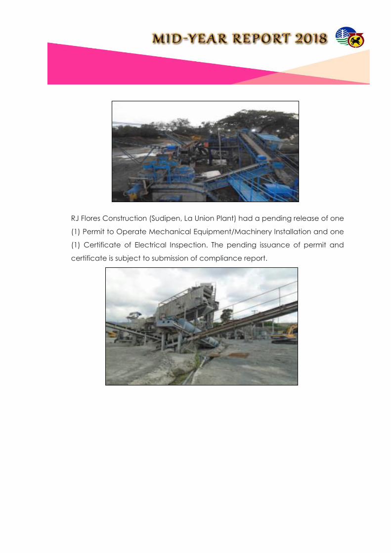
RJ Flores Construction (Sudipen, La Union Plant) had a pending release of one
(1) Permit to Operate Mechanical Equipment/Machinery Installation and one
(1) Certificate of Electrical Inspection. The pending issuance of permit and
certificate is subject to submission of compliance report.

Resolution of Complaints/Cases/Conflicts
1. Complaint on the alleged Illegal mining/ Treasure Hunting at Brgy. Ora West,
Bantay, Ilocos Sur;
2. Unsystematic Extraction of Sand and Gravel along Bolo River within the
municipalities of Bangui, Pagudpud and Dumalneg, Ilocos Norte;
3. Alleged Small Scale Mining Operation inside MAYKAN RESTAURANT, Brgy.
Bautista, Caba, La Union;
4. Alleged Illegal Beach Mining along the seashore of Brgy. Quirino, Bacnotan,
La Union;

5. Complaint against Mary Ann Calica re: CSAG operations in Brgy. Baraoas
Norte, Naguilian, La Union;
6. Investigation on the complaint against HBMA and Mr. Primo Mariano located
at Comilias South, Cervantes, Ilocos Sur and the present situation of Libeg
Bridge;
7. Alleged Illegal mining activity at Brgy. Pallogan, Tagudin, Ilocos Sur.
8. Alleged Illegal mining activity in Brgy. Pocal-Pocal, Alaminos, Pangasinan.
9. Alleged Illegal Mining Activity at Brgy. Amaronan, Umingan, Pangasinan

Anti-Illegal Mining Campaign
Cease and Desist Orders issued/implemented
As a result of the field investigation made by the Office and pursuant to the
provisions of the Republic Act No. 7942, otherwise known as the “Philippine Mining
Act of 1995”, and its Revised Implementing Rules and Regulations, as amended; or
Republic Act No. 7160, also known as the ‘Local Government Code of 1991”,
fourteen (14) persons were issued Cease and Desist Order (CDO) due to their
engagement in the extraction of sand, gravel and other loose and unconsolidated
materials along Bolo River without necessary permit from MGB-I or from the Office of
the Provincial Government of Ilocos Norte.
The sand and gravel quarrying activities along the said river system were found to be
undertaken irresponsibly, unsystematically and not in accord with the concept and
parameters promoting responsible mining.


Charges filed with the Provincial/City Prosecutors Office
1. Criminal complaints filed for violation of BP Blg. 265 and for theft of
minerals pursuant to Section 103 of R.A. No. 7942 against individuals
namely: Lida B. Ayala, Filipino, of legal age and Mr. Francisco B.
Aguinaldo, Jr., Filipino, of legal age who are both residents address at
Bgry. Magallanes, Luna, La Union in extracting / removing / performing
other activities such as buying those 100 sacks of Luna pebbles (minus
5mm sizes) and 180 sacks of Luna pebbles (20-30 mm sizes) from the
beach/es of Brgy. Magallanes, Luna, La Union without any permit to do
so.
2. Complaints filed as to the violation of Section 103 of R.A. 7942 against
TERESITA N. SIY and her driver JOHNNY PASCUAL y CLAVERIA in the
extracting of minerals (500 sacks of white coralline sand) from the
beaches of Burgos, Ilocos Norte and on the process of disposing the
same by transporting it en route to Novaliches, Quezon City where Siy’s
client is located.
Strengthen Multi-partite monitoring system
MMT Operationalized
Multi-partite Monitoring Team Date of Inspection
1st Qtr
Date of Inspection
2nd Qtr
1. MMT-Heirs of Elias E. Olegario March 20-22, 2018 June 26-27, 2018
2. MMT-Holcim Philippines, Inc. February 19-23, 2018 June 4-8, 2018
3. MMT-Pangasinan Group 3 & 5 February 21-23, 2018 May 15-17, 2018
4. MMT-Pangasinan Group II February 8-9, 2018 May 10-11, 2018
5. MMT-Pangasinan Group IV February 27-28, 2018 May 24-25, 2018
6. MMT-ISAG La Union February 27-March 2, 2018 June 5-6, 2018
7. MMT-ONRI February 7-9, 2018 May 2-4, 2018
8.MMT-ISAG Ilocos Sur February 13-16, 2018 May 8-11., 2018
9. MMT-Pangasinan Group 1 & 6 February 6-7, 2018 May 3-4, 2018
10. MMT-Northern Cement
Corporation January 30-31/ February
1-2 April 17-20, 2018

001: NATURAL RESOURCES SUSTAINABLY MANAGED – PROGRAM 2: MINERAL
RESOURCES AND GEOSCIENCES DEVELOPMENT PROGRAM
COMMUNICATION PLAN FOR MINERAL RESOURCES AND GEOSCIENCE
DEVELOPMENT
Conduct of Awareness and Advocacy on Mineral Resources and Geosciences
Development (MRGD)
Dialogues with Sangguniang Panlalawigan / Bayan / Panlungsod/Barangay:
As part of its mandate, the MGB Regional Office No. I continue to build
productive partnerships with its counterparts from the Local Government
Units. Confidence building initiatives are vigorously pursued, being aware of
their role in good governance.
Moreover, the Office also duly - recognizes the role of the LGUs in promoting
the rational development and utilization of the region’s mineral resources as
well as in the enforcement of various Environment and Natural Resources
laws, rules and regulations. Bringing - in their expertise and “clout” in the
Multi-partite Monitoring Team (MMT) Monitoring
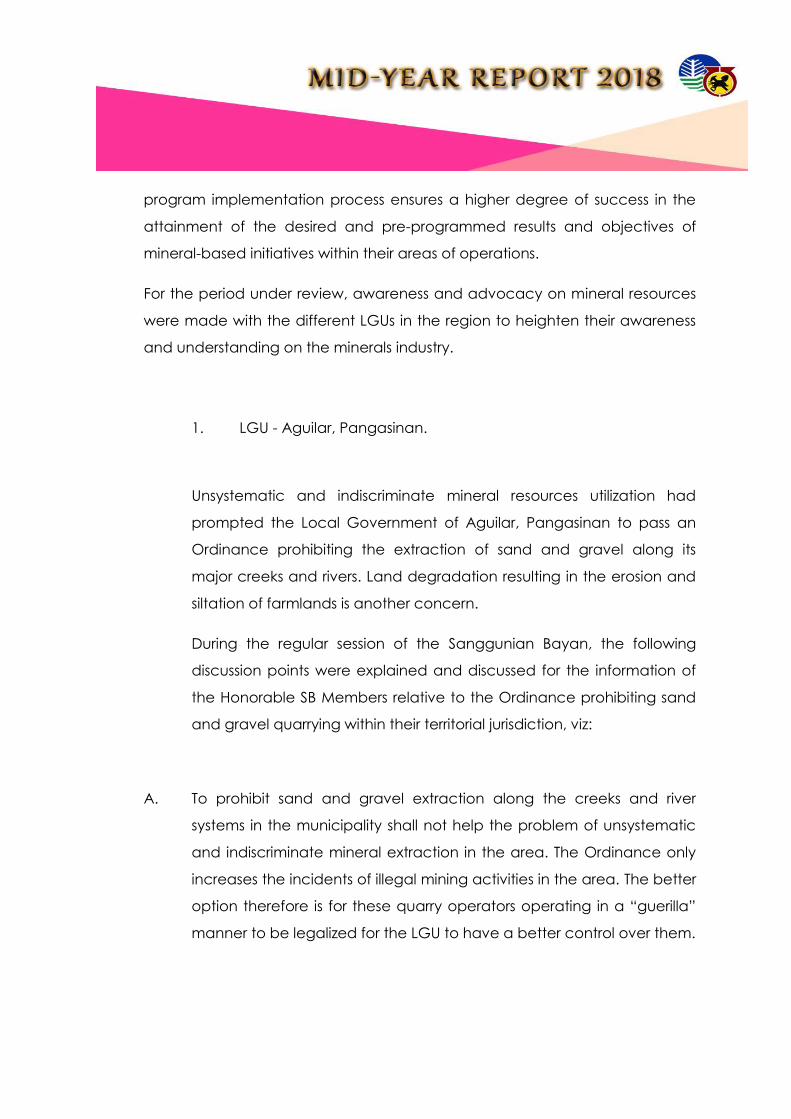
program implementation process ensures a higher degree of success in the
attainment of the desired and pre-programmed results and objectives of
mineral-based initiatives within their areas of operations.
For the period under review, awareness and advocacy on mineral resources
were made with the different LGUs in the region to heighten their awareness
and understanding on the minerals industry.
1. LGU - Aguilar, Pangasinan.
Unsystematic and indiscriminate mineral resources utilization had
prompted the Local Government of Aguilar, Pangasinan to pass an
Ordinance prohibiting the extraction of sand and gravel along its
major creeks and rivers. Land degradation resulting in the erosion and
siltation of farmlands is another concern.
During the regular session of the Sanggunian Bayan, the following
discussion points were explained and discussed for the information of
the Honorable SB Members relative to the Ordinance prohibiting sand
and gravel quarrying within their territorial jurisdiction, viz:
A. To prohibit sand and gravel extraction along the creeks and river
systems in the municipality shall not help the problem of unsystematic
and indiscriminate mineral extraction in the area. The Ordinance only
increases the incidents of illegal mining activities in the area. The better
option therefore is for these quarry operators operating in a “guerilla”
manner to be legalized for the LGU to have a better control over them.
B. Unsystematic and indiscriminate quarrying can be properly addressed
by implementing an efficient monitoring protocols. The rule of law must
prevail, excepting no one. It was stressed that it is only in this manner
that illegal quarrying can be curbed, and the MGB may take a greater
role in empowering the local officials and residents in terms of effecting
apprehension and confiscation of illegally mined, extracted, removed
and disposed sand mineral resources in their area.
C. The prohibition runs counter to the constitutional provision as
enunciated in the declaration of policy mandating the state to
promote the exploration and rational development of the country’s
mineral resources at the same promoting environmental protection
and preserving options of future generations.
2. LGU – Cervantes, Ilocos Sur.
Honorable Mayor Benjamin Maggay III and the entire Sanggunian Bayan
Members of the municipality were present. The discussion is focused on the
opposition of the residents of the municipality to the application for
exploration permit of Cordillera Exploration Company, Inc. (CExCI), the area
of which covers nine (9) barangays.
Mayor Maggay informs the MGB of the following adverse impacts the
application had cause to the local community, viz:
1. It has caused “division” among the local residents, thus, he urgently
requests the MGB to temporarily hold the processing of said
application until such time that the issue has been resolved at the local
level.
2. The issue may cause disruption of the peace and order being enjoyed
in the area.

3. The sentiments of the residents may be heard and given weight, letting
to them to decide, considering that it is their fate and destiny that are
at stake.
The MGB shares the sentiments of the Honorable Mayor, the entire
membership of the Sanggunian Bayan and the people of Cervantes.
However, it was explained that the issue which concerns the settlement of the
opposition raised by the Indigenous Peoples of Cervantes, Ilocos Sur is within
the mandate of the National Commission on the Indigenous Peoples. The
MGB is a mere “observant”.
As to the request for the temporary holding of the application, the Honorable
Mayor was informed that the MGB has no legal basis to do so considering
that the Philippine Mining Act of 1995 does not provide for it. The Honorable
Mayor and his group was however, assured that their issues, complaints,
protests and oppositions against application for Exploration Permit must have
to be resolved prior to its approval.
3. LGU – Bangui, Ilocos Norte (2x)
The observations of the Honorable Secretary of the DENR on the sand and
gravel quarrying/processing along Bolo River was the major point of
discussion.

The LGU Officials headed by Honorable Mayor Fidel A. Cimatu was informed
of the events that had transpired and which led to the issuance of Cease and
Desist Orders. To date fourteen (14) Cease and Desist Orders were issued to
various quarry/crushing plant operators along the said river system. The
seriousness of the Honorable Secretary in protecting the river systems was
echoed to the local officials.
The 2nd dialogue with Honorable Mayor Fidel A. Cimatu and the member of
the Sanggunian Bayan is very engaging, informative and productive for the
reason that the major focus is the preservation of the aesthetic and
ecological value of the Bolo River. DENR officials led by Regional Director
Reynulfo A. Juan led the discussion and provided insights on the effects of the
sand and gravel quarrying in the area without due to regard to the
environment thereby placing in harm’s way the lives, limbs and properties of
local residents.
Among the matters discussed were:
A. The proposed Bolo River Quarry Development Plant (BRQDP);
B. The protocol for the possible lifting of the CDOs;
C. The creation of a 24/7 monitoring team;
D. The conduct of deputation seminar; 24/7 monitoring personnel;
E. The conduct of a seminar on acceptable and prescribed
quarrying methodologies to promote Responsible Mining.

4. LGU – San Fabian, Pangasinan
The appearance of personnel from the MGB Regional Office No. I before the
Members of the Sanggunian Bayan of San Fabian, Pangasinan was
precipitated by the “ban” on sand and gravel quarrying in Brgy. Binday, San
Fabian, Pangasinan issued by the MGB, Regional Office No. I.
A query was posed by the local officials on the following:
a. Unabated extraction of sand and gravel in the area despite the
existence of the “ban”;
b. The level of coordination between the MGB and Provincial
Government of Pangasinan in terms of monitoring the sand and gravel
quarrying in the area;
c. The participation of the LGU in the processing, issuance and approval
of sand and gravel permits, specifically in the issuance of the required
Endorsement; and
d. Possible entry points of the LGU in addressing the issue on illegal mining;
and
e. Sharing of the proceeds derived from the sand and gravel quarrying in
the area; and
f. Status of the boundary dispute the Municipalities of San Fabian and
San Jacinto.
It was clarified that there is no ban issued by the MGB. Instead a Suspension
Order was issued to certain quarry operators in the area for violations to the
terms and conditions of their permits.

The dialogue was attended together with DENR PENRO Raymund Gayo of
the Province of Pangasinan, DENR CENRO Celso Salazar of Dagupan City, Mr.
Mixon Flores of the Environment and Natural Resources Office/Natural
Resources Regulatory Group of the Province of Pangasinan.
Dialogue with other groups (Religious Groups, CSO, Academe, etc.)
The MGB Regional Office No. I is cognizant of the role played by the civil
society in the implementation of mineral – based programs and projects and
in the enforcement of Environment and Natural Resources laws, rules and
regulations. The need to continuously solicit their pro-active participation,
unwavering support and cooperation is therefore imperative.
For the period under review, three (3) dialogues were conducted.
1. Quarry Operators and Concerned Residents in the Municipality of Bangui,
Ilocos Norte.
A dialogue explaining to the quarry/crushing plant operators the
impacts of their respective quarry operations to the Bolo River
ecosystem and to the local residents residing within the immediate
vicinity of said river system was made.
An urgent call was made requiring them to immediately rehabilitate
the disturbed areas within their respective permit areas. It was
emphasized that sand and gravel quarrying may only resume after the
necessary rehabilitation measures had been implemented and the
same had been properly validated by DENR PENRO Ilocos Norte and
MGB Reional Office No. I personnel.
The quarry/crushing plant operators agreed to the terms laid - out to
ensure Responsible Mining is carried – out in their subsequent
quarrying/crushing operations.

2. Selected College Students of Pangasinan State University.
The college students were treated to a presentation on the following:
a. Operational structure of the MGB Regional Office;
b. Programs and projects and their impacts to the target beneficiaries;
c. A profile of the minerals industry in the region and its direct
contributions to local and regional and national economy;
d. Linkages ad networking strategies to widen the backbone of
participation of the civil society in the mineral development and
utilization process.
e. Problems and opportunities faced by the industry; and initiatives aimed
at making it a catalyst for economic development at the grass root
level.
3. National Commission on Indigenous Peoples.
A dialogue was done with personnel of the National Commission on
Indigenous Peoples – Ilocos Sur Province (NCIP-IS) in relation to the
status of the Free and Prior Informed Consent (FPIC) being secured by
Cordillera Exploration Corporation, Inc. (CExCI), of which most of the
area is in the Municipality of Cervantes, Ilocos Sur.
Initially, the Local Government of Cervantes, Ilocos Sur passed a
number of Resolutions expressing their oppositionto the application of
CExCI for Exploration Permit.
Led by Atty. Jonathan Bansigan, OIC – Regional Director of NCIP, he
informed the body of the retraction of the “YES” votes of some of the
affected barangays to the proposed exploration activity. And
considering that the issue has become very intense and at times

resulted in the misunderstanding between and among the residents,
the NCIP has decided to momentarily stop the processing of the FPIC.
The MGB for its part committed to call CExCI to a technical
conference to get some information in relation to the extent and
coverage of the “ground works” they are doing in the area.
MGB RI Regional Director Carlos A. Tayag stressing a point during the
discussion with local officials headed by Mayor Fidel A. Cimatu regarding
the stoppage of sand and gravel quarrying along the Bolo River.

A dialogue with the quarry/crushing plant operators and some of the affected
residents was made to impress upon them the impact of the unsystematic and
indiscriminate sand and gravel being done in the area and so with the
actions and interventions being done by the DENR/MGB/EMB Regional Offices.
DENR PENRO Victor Dabalos of the Province of Ilocos Norte giving an
inspirational talk. Also present were Engr. Roland Fravalde, Atty. Mario S.
Timario, Engr. Paula Blessie Morante, Engr. John Rhod Sonsos, the mining
engineer embedded in the Province of Ilocos Norte and Engr. Darryl Sagid of
EMB RI.

The findings led to the issuance of CEASE AND DESIST ORDERS.

The MGB Regional Office No. I in close coordination with the Local
Government Units takes a greater role in the monitoring on the level
of compliance to the Cease and Desist Orders earlier issued. Non-
compliance means non-lifting of the CDO.
Honorable Mayor Fidel A. Cimatu and some local officials were briefed
on the proposed Bolo River Quarry Development Project, an initiative
of the MGB regional Office No. I to address the issue on
indiscriminate and unsystematic quarrying along the Bolo River.

Radio/TV Guestings
A total of six (6) Radio/TV Broadcast/ Guesting were completed
for the semester
Generation/Publication/Dissemination of Information and IEC Materials:
MGB-1 Website www.region1.mgb.gov.ph is being maintained
by the Office for better and easier access of clients to the
services being offered by the Office;
Ten (10) articles posted on the Website;

Two (2) IEC materials were produced, reproduced and distributed
during fora, conferences, dialogues and meetings. Some were
requested by walk-in clients;
Sixteen (16) Statistical Reports were prepared and submitted to MGB-
Central Office;
Twelve (12) updating of tenement maps which is done on a bi-monthly
basis; and
Eighteen (18) MRGS reports were prepared. These are the databases
of the Mining Tenement Statistics Report, SHES Database
Management, Mining Tenement Database, Mine Rehabilitation Fund
Report.

Capacity Building
For MGB Personnel
1. Seminar on the Standardization Checklist for the Monitoring of Tenements,
Safety, Environment and Social Development Programs;
2. 6th Mines Adjudication Board and Panel of Arbitrator’s Seminar-Workshop on
Mining Conflict/Dispute Resolution;
3. 5th Mining Engineer’s Convention;
4. Seminar/Symposium on Environmental Crimes.

For LGUs and other stakeholders (NGAs, CSOs, etc.)
1. 17th Regional Mining Summit;
2. Orientation Seminar on the Standardization Checklist for the Monitoring of
Tenements, Safety, Environment and Social Development Programs;
3. IEC on Centralized Records Systems of Various Mining Permits/Contracts
issued by LGU and PMRB

For small-scale miners
1. 17th Regional Mining Summit;
National Linkages
Linkages with NEDA
Linkages coordinated with OCD
Linkages coordinated with DOST (ICIEERD)
Linkages coordinated with LGU
Linkages coordinated with I-MINE
Linkages coordinated with PSEM-NLC
Linkages coordinated with ENR-SECOM

003: ADAPTIVE CAPACITIES OF HUMAN COMMUNITIES AND NATURAL SYSTEMS
IMPROVED – PROGRAM 1: GEOLOGICAL RISK REDUCTION AND RESILIENCY PROGRAM
Geohazard Assessment - Identification and Mapping of Geohazards for Critical Land
Areas
a) Vulnerability and Risk Assessment (VRA) and Updating of 1:10,000 Geohazard
Maps
MGB-I is continuously undertaking the Vulnerability and Risk Assessment (VRA)
and Updating of 1:10,000 Geohazard Maps in order to complete the targeted
12 municipalities for CY 2018. For the first semester, the VRA team has
accomplished seven (7) municipalities, namely:
Alcala, Pangasinan;
Binmaley, Pangasinan;
San Emilio, Ilocos Sur;
Sta. Catalina, Ilocos Sur;
San Vicente, Ilocos Sur;
Naguillan, La Union; and
Aringay, La Union.
This is in connection with the government’s continuous effort to mitigate the
adverse effects of natural hazards; mainly floods and rain-induced landslide
and to quantify the vulnerability of cities and municipalities based on their
exposure to hazards. In addition, it aims to determine the extent of the
possible impacts or damages of these natural hazards to the elements at risk
(e.g., people and infrastructures).

The project’s main objective is to produce risk exposure maps and technical
reports and to update the existing 1:10,000 scale geohazard maps. These
exposure maps contain substantial information about the overall exposure of
elements at risk to a specific hazard present in an area. Furthermore, the
project’s final output can be used by the local, provincial and regional sector
for their disaster preparedness and awareness, as well as their management,
mitigation and land use plan.
In order to achieve the above-mentioned objective, specific methodologies
were employed. These include gathering of spatial and demographic data
from the key persons of the LGU, anecdotal accounts/ interview with the
barangay officials and residents regarding the hazards present in the area
and actual ground assessment. These data acquired can now generate
exposure maps through GIS processing.
Data gathering, actual ground assessment and Interview with the
key persons per Barangay regarding the hazards present in their
area.

b) Ground Subsidence Assessment
The Mines and Geosciences Bureau (MGB) of the Department of Environment
and Natural Resources Regional Office No. 1 (DENR Region 1) has expanded
its National Geohazard Mapping and Assessment Program to include Karst
Subsidence Mapping and Hazard Assessment in areas of the country that are
characterized by Karst topography. Thus, during the period, March 16-26,
2018 and April 16 to May 7, 2018, Karst Subsidence Mapping and Hazard
Residents pointing the maximum level of flood.
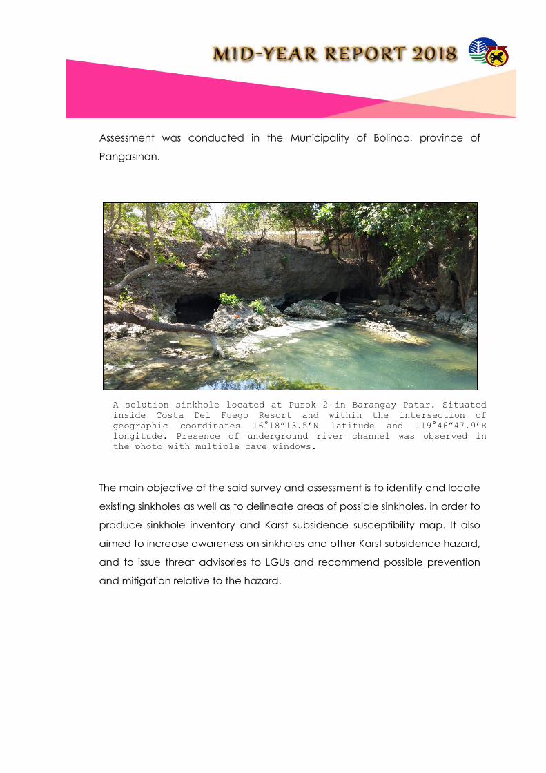
Assessment was conducted in the Municipality of Bolinao, province of
Pangasinan.
The main objective of the said survey and assessment is to identify and locate
existing sinkholes as well as to delineate areas of possible sinkholes, in order to
produce sinkhole inventory and Karst subsidence susceptibility map. It also
aimed to increase awareness on sinkholes and other Karst subsidence hazard,
and to issue threat advisories to LGUs and recommend possible prevention
and mitigation relative to the hazard.
A solution sinkhole located at Purok 2 in Barangay Patar. Situated
inside Costa Del Fuego Resort and within the intersection of
geographic coordinates 16°18”13.5’N latitude and 119°46”47.9’E
longitude. Presence of underground river channel was observed in
the photo with multiple cave windows.

c) Production of Geohazard Maps
d) Geohzard IEC Materials Dissemination
IEC materials consisting of maps (120), posters (610), VCD (35), pamphlets
and/or flyers (422) on “BAHA” and “GUHO” were distributed to LGUs, students
and clienteles. Geohazard maps with a scale of 1:10,000 scale were
uploaded in the website. Advisories were likewise re-issued to all cities and
municipalities in the region.
e) Capacity Building
1. Geosciences Workshop
2. Training On Basic Safety Of Life At Sea (Solas)
3. Geovia Surpac
4. Basic And Advance Gis Mapping
5. Seminar Workshop on Strategic Planning for Marine Geological
Survey and Research
Ground Penetrating Radar Survey at the National Highway in Barangay
Concordia.

f) Conduct of IEC
SEMINARS/ WORKSHOPS FOR LGUs
In order to increase awareness and provide additional technical input to the LGU
regarding Risk Exposure Analysis and its importance to attain sustainable
development through comprehensive land-use, development and disaster risk
management planning, Information, Education and Communication Campaign for
VRA project was conducted.
IEC ON VULNERABILITY RISK ASSESSMENT (VRA) MAPS
MUNICIPALITY DATE NUMBER OF
BARANGAYS
1. Vigan City, Ilocos Sur April 26-28, 2018 39
2. Candon City, Ilocos Sur April 19-21, 2018 42
3. Santa, Ilocos Sur April 23-25, 2018 26
4. Urdaneta, Pangasinan May 24-26, 2018 34
5. Villasis, Pangasinan May 9-11, 2018 21
6. Alaminos City, Pangasinan May 29-31, 2018 39

LECTURES PRESENTED
Lecture on Geohazards last January 17-19, 2018 at Barangay
Namalangan , Rizal, Sacuya, Santa Ilocos Sur as part of their
Development of Mining Technology and Geosciences (DMTG) of Ms
Jennifer Bantolina. (Socrates G. Gaerlan/Randie Ceasar A. Apilado);
Ms. Vilma A. Vecino attended as Lecturer / Learning Service Provider
to discuss on the topic “ Geohazard Assessment Groundwater
Assessment and Responsible Mining “ which is scheduled on February
15, 2018 as per invitation of PENRO La Union who will be conducting a
Learning Event on Environmental and Natural Resources (ENR)
Concerns on February 13-15, 2018 at Puerto San Juan Resort , San Juan
, La Union;
Ms. Vilma A. Vecino attended as lecturer/ speaker re: “Understanding
Geological Hazards and Understanding Landslides and Subsidence
Hazards” on the Two-day DRRM Course for Cooperative Sector for the
Province of Ilocos Norte held at Rivermount Hotel and Resort, Brgy. 18,
San Isidro, Sarrat, Ilocos Norte last February 22-23, 2018;
Presentation of VRA Methodology and Risk
Exposure Maps and results of the Vulnerability
and Risk Assessment
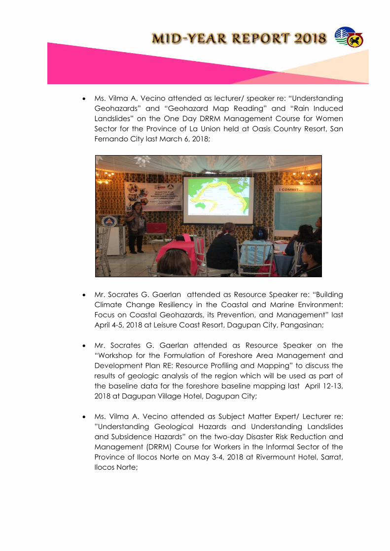
Ms. Vilma A. Vecino attended as lecturer/ speaker re: “Understanding
Geohazards” and “Geohazard Map Reading” and “Rain Induced
Landslides” on the One Day DRRM Management Course for Women
Sector for the Province of La Union held at Oasis Country Resort, San
Fernando City last March 6, 2018;
Mr. Socrates G. Gaerlan attended as Resource Speaker re: “Building
Climate Change Resiliency in the Coastal and Marine Environment:
Focus on Coastal Geohazards, its Prevention, and Management” last
April 4-5, 2018 at Leisure Coast Resort, Dagupan City, Pangasinan;
Mr. Socrates G. Gaerlan attended as Resource Speaker on the
“Workshop for the Formulation of Foreshore Area Management and
Development Plan RE: Resource Profiling and Mapping” to discuss the
results of geologic analysis of the region which will be used as part of
the baseline data for the foreshore baseline mapping last April 12-13,
2018 at Dagupan Village Hotel, Dagupan City;
Ms. Vilma A. Vecino attended as Subject Matter Expert/ Lecturer re:
”Understanding Geological Hazards and Understanding Landslides
and Subsidence Hazards” on the two-day Disaster Risk Reduction and
Management (DRRM) Course for Workers in the Informal Sector of the
Province of Ilocos Norte on May 3-4, 2018 at Rivermount Hotel, Sarrat,
Ilocos Norte;

Ms. Vilma A. Vecino attended as Subject Matter Expert (SME) to
discuss the topics on “Understanding Geological Hazards and
Understanding Landslides and Subsidence Hazards” on the One -day
Basic Disaster Risk Reduction and Management Training for Youth and
Student Sector scheduled on May 23, 2018;
Ms. Vilma A. Vecino attended as Resource Speaker in the DRRM
Training Course for Senior Citizens in Dagupan City and facilitate topics
for the World Vision's Training on Disaster Preparedness in Lingayen last
June 18-20, 2018; and
Ms. Vilma A. Vecino attended as Subject Matter Expert (SME) to discuss
the topics on “Understanding Geological Hazards and Understanding
Landslides and Subsidence Hazards” on the One -day Disaster Risk
Reduction and Management Training for the Victims of Disaster s
Sector of Ilocos Norte (June 25-27, 2018).

g) Geohazard Operation Center
h) Coastal Geohazard
Mines and Geosciences Bureau – Regional Office No.1 Coastal Geohazard
Assessment and Mapping Team is conducting surveys along the coastal
area/barangays in the province of Ilocos Norte.
The general purpose of this study is to investigate the coastal erosion,
accretion and other coastal geohazards that could cause vulnerable
impacts on the residents situated along the coastal areas. Thus, this study
creates an effort to help or at least mitigate the possible effects of these
hazards identified in the area. In this manner, the observations of the residents
are collected through interview to further establish a conclusion that could
define the past coastal setting in their area.
The historical accounts are also collected during the survey which includes
the coastal geohazards that are present in the area and personal view of the
residents about hazard mitigations. The Beach Profiling Program was also
done by the team to determine the present outline or slope of the beach
through the implementation of Emery Method. The data collected are used

to compare the beach slope to other areas. The beach profiling program
was done only in areas where beach are exposed both in the mainland and
island barangays.
The study shall benefit the local residents and Local Government Units in
promoting awareness to the Coastal Hazards in their area and also possible
mitigations that could lessen the effects of identified coastal vulnerabilities.
The fieldwork started last February, and as of June, six (6) coastal
municipalities of Ilocos Norte were surveyed and given threat advisories.
These municipalities are:
Badoc, Ilocos Norte;
Currimao, Ilocos Norte;
Bangui, Ilocos Norte;
Pagudpud, Ilocos Norte;
Burgos, Ilocos Norte; and
Pasuquin Ilocos Norte.
Beach Profiling at purok 2, Barangay Gabut Norte, Badoc, Ilocos Norte
(left), and purok 4 Gabut Sur (right) Badoc, Ilocos Norte. Beach
profiling is used to study dynamic beach processes and the effect of
waves, current, and anthropogenic structures on the beach.

i) Geologic Mapping
Geologic quadrangle mapping is one of the priority projects of the
Government under the Geological Assessment Program of the Mines and
Geosciences Bureau (MGB) Regional Office I. This project is being conducted
in order to produce and complete geological maps of the Region I.
The generated 1:500 scale geologic maps will serve as the base map for
other geological surveys like geo-hazard assessment, hydrogeological survey
and other geological resources mapping and can be used for land use
development planning of the local government units (LGUs).
There are two (2) quadrangles that were surveyed for the first semester of the
year; these are Sinait and Solsona Quadrangle. The first geological mapping
was conducted in Sinait Quadrangle dated on March 20-28, 2018 and then
followed on the areas of Solsona Quadrangle which was surveyed on April 17
to May 15, 2018 inclusive. In contrast, Sinait quadrangle is updating and/or
checking area whereas Solsona quadrangle has no data.
The team conducted beach profiling and coastal tracking along the
coastlines of Burgos, Ilocos Norte. Coordinates: 18° 30’ 02.9’’N 120° 34’ 05.0’’E (Paayas)

Sinait Quadrangle is bounded by geographical coordinates of North 17° 50’
00” – 18° 00’ 00” Latitude and East 120° 15’ 00” – 120° 30’ 00” Longitude while
Solsona Quadrangle is surrounded by geographical coordinates of 18° 00’ 00”
- 18° 10’ 00” latitude and 120° 45’ 00” - 121° 00’ 00” longitude.
The procedure applied during fieldwork includes identification of rocks and
minerals exposed along the rivers, roads, and agricultural lands, mapping of
geological structures (e.g. faults, fracture and joints), collection of rock
samples and checking mineralization (metallica and non-metallic) present in
the area.
The systematic procedures of describing the (a)
different types of rocks, (b) tracing geological
contacts/boundaries, (c) river traverse, (d) structural
analysis and (e) checking mineralization present in the
mapping area.

Based on the correlation between the previous and recent geological data
derived from Sinait Quadrangle, it was confirmed that all inferred lithologic
units in the area are still present and stratigraphically correct. The formational
units that were verified in the quadrangle are the following (arranged from
oldest to youngest): Ilocos Peridotite, Laoag Formation, Uplifted Corals and
Quaternary Alluvium.
Meanwhile, Solsona quadrangle comprises of eight (8) formational units
namely; Metavolcanics, Diorite Complex, Dacite, Andesite, Schist, Baruyen-
Bangui Formation, Dagot Limestone and Quaternary Alluvium.
In terms of mineral resource potential, there is no significant mineralization
found in Sinait quadrangle and there are no mining activities reported in the
area. In contrast, Solsona quadrangle shows surface manifestation of
An outcrop (see man for scale) of Andesite (black
colored) in contact with the Diorite Complex (light
colored) that were encountered during the conduct of
reconnaissance survey along Solsona River. It is
moderately vegetated covered by cogon grass and
secondary forest trees.

probably copper mineralization. Abundant sulfide minerals predominantly
pyrite was observed in diorite outcrops occurring as disseminated and
fracture fills. However there are no recent mining activities reported in the
area.
j) Mineral Resource Inventory
Mineral Resource Inventory Map of Region I
k) Groundwater Reource Assessment
For the Calendar Year 2018, Special Order No. 2018-89, with the subject
“AUTHORIZING CERTAIN PERSONNEL OF THE MINES AND GEOSCIENCES BUREAU
REGIONAL OFFICE NO. 1 TO CONDUCT HYDROGEOLOGICAL ASSESSMENT
SURVEY IN THE PROVINCE OF ABRA, CORDILLERA ADMINISTRATIVE REGION”

tasked the MGB RO1 Hydrogeological Team to assess the twenty-seven
municipalities of Abra Province. The team accomplished nine (9)
municipalities namely: San Isidro (April 2018), Tubo (April 2018), Luba (April
2018), Daguioman (April 2018), Bucloc (April 2018) Tineg (May 2018), Lacub
(May 2018), Malibcong (June 2018), and Licuan-Baay (June 2018).
The objective of the project is to determine the availability and quality of
groundwater in the various rock units / geologic formations in the entire
country; establish the quality/chemistry of groundwater in groundwater
basins; establish the potentials and limitations of available groundwater in the
various groundwater basins; delineate areas with groundwater resource
potential; and assess groundwater vulnerability of aquifers in the country.
Methodologies used in the survey consists of Well/Spring Inventory,
Hydrogeological Mapping and Water Sampling. Inventory of springs or wells
A hand held GPS is used to record the geographic location of wells
and springs. Chemical analysis using the Hack meter was done to
water samples to measure the TDS, conductivity, temperature, and
salinity level.

was conducted with the use of a Global Positioning System (GPS) to locate its
geographic position. Measurement of well depth and groundwater level was
carried out with the use of a battery operated water level indicator that emits
sound upon reaching the water surface. Mapping method is done through
the use of a topographic map which serves as guide or base map of the
study area, brunton compass to measure the strike and dip of the structures
encountered during the field, and a sample pick to gather rock samples to
identify physical properties of the rock. Water samples collected from pump
wells, dug wells and springs were subjected to water quality analysis using a
Hach meter. The in-situ test determines the temperature, pH, electric
conductivity, total dissolved solids (TDS) and salinity of the water sample.
The rainy season makes assessing the mountainous areas quite challenging.
Thus, some sitios of the far flung barangays were not included in the survey.
Pump well and dug well were measured by using a battery
operated water level indicator to measure the well depth
and depth to groundwater.
The team was able to inventory a total of seventeen (17) for dug/pump wells
and 122 springs during the field work.
l) Miscellaneous Geological Services
Geological Site Scoping on the propsed Sanlitary Landfill Site
located at Barangay Tangaoan , Sta. Maria, Ilocos Sur last January
4-6, 2018.
Geological Site Scoping on the Proposed Sanitary Landfill Site
located at Barangay Talogtog, San Juan La Union last January 18-
19, 2018.
Geological Site Scoping on the proposed Engineered Sanitary
Landfill facility located at Barangay Saoay, City of San Fernando, La
Union last January 30-31, 2018.
Hydrogeological and Georesistivity Survey at Sentinella Hill of Bangui
, Ilocos Norte as per request of Mayor Flidel Cimatu of Bangui, IN last
February 13-16, 2018.
Geological and structural assessment to locate and propose Small
Water Impounding dams and pinky watersheds in the Municipality of
Bangui, Ilocos Norte last February 20-24, 2018.
Geological assessment and test pit inspection in the proposed
sanitary landfill site in the City of San Fernando City, La Union last
March 1, 2018.
Geological Site Scoping on the proposed Ecozone of about 306
hectares located in Mt. Tapao, Barangay Poblacion, Suyo, Ilocos Sur
last March 17-19, 2018.

Geohazard Identification Survey (GIS) for the proposed Beverly Hills
Subdivision in Brgy. Sta. Rita West, Aringay, La Union last March 20,
2018.
Geologic Assessment of Sanitary Landfill in Brgy. San Agustin Norte,
Agoo, La Union last March 21-23, 2018.
Geological Site Scoping on the proposed Sanitary Landfill Site
located at Barangay San Miguel, Burgos, Pangasinan last April 4-5,
2018.
Geological Site Scoping on the proposed Sanitary Landfill Site
located at Infanta, Pangasinan last April 6-7, 2018.
Geohazard Identification Survey for the proposed Housing Project
located at Cabaroan, Tagudin, Ilocos Sur last May 2-4, 2018.
The assessed expansion site of the Sanitary
Landfill of Agoo is located along the northwest of
the SLF. As can be seen, leachate and gas pipes
are already installed, and dumping of waste
materials was already conducted.

Geological Site Scoping for the proposed Sanitary Landfill Site in
Barangay Pugaro, Municipality of Manaoag , Province of
Pangasinan last May 16-18, 2018.
Geological Assessment for the proposed Sanitary Landfill site
located at Barangay Agpay , Burgos, La Union last May 31- June 2,
2018.
Soil Sampling on the propsed site to see if the
clay is enough for a liner.

Geological Site Scoping at Barangay No. 22 Dilanis, Pasuquin , Ilocos
Norte last June 13-15, 2018.

GENDER AND DEVELOPMENT
WOMEN MAKE CHANGE – In celebration of the National Women’s Month
2018, personnel from the Mines and Geosciences Bureau Regional Office No. 1
actively participated in the walk for gender equality organized by the Region 1
Advocates for Gender Equality (R.A.G.E.) on March 2, 2018 at the Don
Mariano Marcos Memorial State University-Mid La Union Campus. The theme,
“We make change. Work for Women” highlights the empowerment of women
as active contributors to and claimholders of development. This theme is
constant from 2017-2022 where it also showcases the pursuit of development
anchored in the commitment of “Malasakit at Pagbabago” or true compassion
or real change.
SAN FERNANDO CITY, La Union –Department of Environment and Natural
Resources-I, Mines and Geosciences Bureau-I and Environmental Management
Bureau-I conducted a forum showcasing women exemplar in the field of
natural resources on March 15, 2018 at the DENR-1 Social Hall.
Along with this, a bazar featuring products from different people’s
organizations in the region was established in the parking area of the DENR-1
building. This also includes services and products of persons with disabilities
(PWDs). The ribbon cutting ceremony was led by ARD Gwendolyn Bambalan,

ARD Leduina Co, EMB-1 Regional Director Ma. Victoria Abrera and Director
Lourdes Wagan.
TRAINING ON ENHANCED GENDER MAINSTREAMING EVALUATION
FRAMEWORKON APRIL 2-6, 2017 AT THE MICROTEL BY WYNDHAM IN
DILIMAN, QUEZON CITY
The Mines and Geosciences Bureau through the GAD Focal Point System
(GFPS) conducted the said 5-day training which also included members of the
GAD Regional Technical Working Group.
It aimed to increase the knowledge of the participants on the GMEF which is a
tool to measure the extent of the gender mainstreaming efforts of
organizations, National Government Agencies and Local Government Units. It
is also meant to assist the GFPS members in measuring gains and success, as
well as pinpoint areas for improvement in the way they mainstream the
gender and development in their organization.

MGB 1 personnel undergo Gender Sensitivity Training
the Mines and Geosciences Bureau Region 1 conducted another Gender
Sensitivity Training (GST) for more or less 20 personnel last March 27, 2018 at
the Oasis Country Resort in San Fernando City, La Union. The said training
aimed to mainstream gender concerns to make women’s and men’s concerns
as an integral dimension of the design, implementation, monitoring and
evaluation of the policies and programs as mandated under Republic Act. No.
9710 or the Magna Carta of Women.