Embed Size (px)
Citation preview
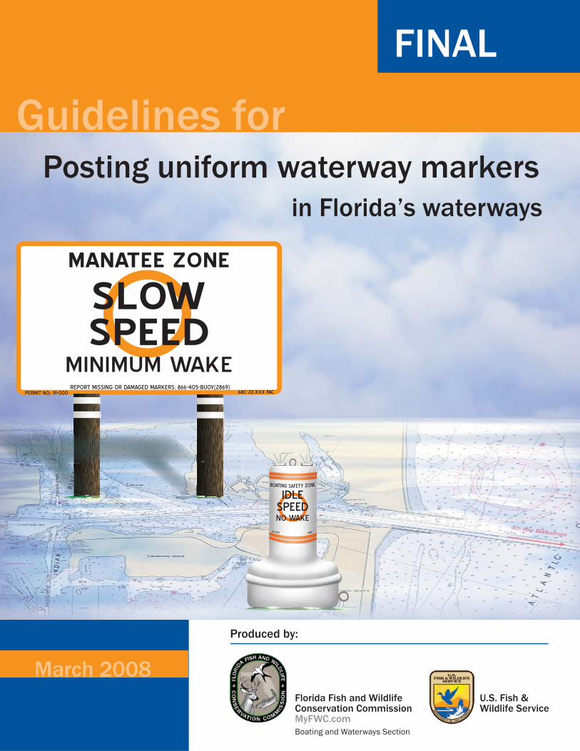
PERMIT NO.: 91-000 68C-22.XXX FAC
MANATEE ZONE
SLOWSPEED
MINIMUM WAKE
IDLESPEEDNO WAKE
91-000 68D-
FINAL
REPORT MISSING OR DAMAGED MARKERS: 866-405-BUOY(2869)
BOATING SAFETY ZONE
March 2008
Posting uniform waterway markersin Florida’s waterways
U.S. Fish & Wildlife Service
Produced by:
Florida Fish and Wildlife Conservation CommissionMyFWC.comBoating and Waterways Section
Guidelines for
These guidelines were developed in part by the Manatee Protection Working Group, a stakeholder group convened by the US Fish and Wildlife Service’s (USFWS) Florida Manatee Recovery and ImplementationTeam. Membership in the Manatee Protection Working Group includes stakeholders from the Coastal Conservation Association of Florida, Defenders of Wildlife, the Florida Fish and Wildlife Conservation Commission (FWC), the Florida Inland Navigational District (FIND), the Marine Industries Association, Mote Marine Laboratory, The Ocean Conservancy, Save the Manatee Club, Standing Watch, the US Coast Guard (USCG), and the USFWS. This document represents the combined knowledge, experience, and expertise of the working group members and their respective organizations. We gratefully acknowledge their extensive efforts over the past few years.
Acknowledgements
02088 | dv
Introduction . . . . . . . . . . . . . . . . . . . . . . . . . . . . . . . . . . . . . . . . . . . . . . . . . . . 1Regulatory waterway markers. . . . . . . . . . . . . . . . . . . . . . . . . . . . . . . . . . . . . . 2Regulatory and non-regulatory (informational) zones . . . . . . . . . . . . . . . . . . . 3 Regulatory zones. . . . . . . . . . . . . . . . . . . . . . . . . . . . . . . . . . . . . . . . . . . . . . 3 Non-regulatory zones . . . . . . . . . . . . . . . . . . . . . . . . . . . . . . . . . . . . . . . . . . 3 Establishing regulatory zones . . . . . . . . . . . . . . . . . . . . . . . . . . . . . . . . . . . . . . 4 Federal regulations. . . . . . . . . . . . . . . . . . . . . . . . . . . . . . . . . . . . . . . . . . . . 4 Florida regulations . . . . . . . . . . . . . . . . . . . . . . . . . . . . . . . . . . . . . . . . . . . . 4 Local government regulations . . . . . . . . . . . . . . . . . . . . . . . . . . . . . . . . . . . 5 Developing regulations. . . . . . . . . . . . . . . . . . . . . . . . . . . . . . . . . . . . . . . . . 5 Permitting . . . . . . . . . . . . . . . . . . . . . . . . . . . . . . . . . . . . . . . . . . . . . . . . . . . 5 Waterway marker plan. . . . . . . . . . . . . . . . . . . . . . . . . . . . . . . . . . . . . . . . . 5 Regulatory zones. . . . . . . . . . . . . . . . . . . . . . . . . . . . . . . . . . . . . . . . . . . . . . 8 Regulatory zone confi gurations . . . . . . . . . . . . . . . . . . . . . . . . . . . . . . . . . 10Uniform waterway marker specifi cations . . . . . . . . . . . . . . . . . . . . . . . . . . . . 13 Sign basics. . . . . . . . . . . . . . . . . . . . . . . . . . . . . . . . . . . . . . . . . . . . . . . . . . 13
Buoy basics . . . . . . . . . . . . . . . . . . . . . . . . . . . . . . . . . . . . . . . . . . . . . . . . . 14 Waterway marker symbols. . . . . . . . . . . . . . . . . . . . . . . . . . . . . . . . . . . . . 15 Waterway marker messages . . . . . . . . . . . . . . . . . . . . . . . . . . . . . . . . . . . 16 Placement of the permit number and regulations . . . . . . . . . . . . . . . . . . 18Planning and placement of waterway markers. . . . . . . . . . . . . . . . . . . . . . . . 19 Marker placement guidelines. . . . . . . . . . . . . . . . . . . . . . . . . . . . . . . . . . . 19 Summary of Procedures . . . . . . . . . . . . . . . . . . . . . . . . . . . . . . . . . . . . . . . 21 What you should know about permitting . . . . . . . . . . . . . . . . . . . . . . . . . 22Public awareness. . . . . . . . . . . . . . . . . . . . . . . . . . . . . . . . . . . . . . . . . . . . . . . . 23Maintenance, repair, and response . . . . . . . . . . . . . . . . . . . . . . . . . . . . . . . . . 24 Marker maintenance . . . . . . . . . . . . . . . . . . . . . . . . . . . . . . . . . . . . . . . . . 24 Marker inventory . . . . . . . . . . . . . . . . . . . . . . . . . . . . . . . . . . . . . . . . . . . . 25 On-call and emergency response programs. . . . . . . . . . . . . . . . . . . . . . . . 25Appendices
Regulatory sign examples . . . . . . . . . . . . . . . . . . . . . . . . . . . . . . . . . . . . . A Buoy and sign design drawings and specifi cations. . . . . . . . . . . . . . . . . . B Permit application . . . . . . . . . . . . . . . . . . . . . . . . . . . . . . . . . . . . . . . . . . . C Chapter 68C-22 Florida Administrative Code . . . . . . . . . . . . . . . . . . . . . D Chapter 68D-23 Florida Administrative Code . . . . . . . . . . . . . . . . . . . . . E Code of Federal Regulations, Title 50, Chapter 1, Part 17-100 . . . . . . . F USCG Aids to Navigation, Title 33-Part 66 . . . . . . . . . . . . . . . . . . . . . . . G
Table of contents
ATON . . . . . . . . . . . . . . . . . . . . . . . . . . . . . . . . . . . . . . . . Aid to NavigationCFR . . . . . . . . . . . . . . . . . . . . . . . . . . . . . . . . . Code of Federal RegulationsFAC . . . . . . . . . . . . . . . . . . . . . . . . . . . . . . . . . Florida Administrative CodeFDACS . . . . . Florida Department of Agriculture and Consumer ServicesFDEP . . . . . . . . . . . . . . Florida Department of Environmental ProtectionFIND . . . . . . . . . . . . . . . . . . . . . . . . . . . Florida Inland Navigation DistrictFKNMS . . . . . . . . . . . . . . . . . . . . Florida Keys National Marine SanctuaryFS . . . . . . . . . . . . . . . . . . . . . . . . . . . . . . . . . . . . . . . . . . . . Florida StatutesFWC . . . . . . . . . . . . . Florida Fish and Wildlife Conservation Commission GIS . . . . . . . . . . . . . . . . . . . . . . . . . . . . . Geographic Information SystemsGPS . . . . . . . . . . . . . . . . . . . . . . . . . . . . . . . . . . Global Positioning SystemICW . . . . . . . . . . . . . . . . . . . . . . . . . . . . . . . . . . . . . Intracoastal Waterway LNM . . . . . . . . . . . . . . . . . . . . . . . . . . . . . . . . . . . Local Notice to MarinersMPH . . . . . . . . . . . . . . . . . . . . . . . . . . . . . . . . . . . . . . . . . . . Miles Per HourNMSA . . . . . . . . . . . . . . . . . . . . . . . . . . . National Marine Sanctuaries ActNOAA . . . . . . . . . . . . . National Oceanic and Atmospheric AdministrationNWR . . . . . . . . . . . . . . . . . . . . . . . . . . . . . . . . . . . National Wildlife RefugePATON . . . . . . . . . . . . . . . . . . . . . . . . . . . . . . . . Private Aid to NavigationUSACE . . . . . . . . . . . . . . . . . . . . . . . . . . . . . . US Army Corps of EngineersUSCG . . . . . . . . . . . . . . . . . . . . . . . . . . . . . . . . United States Coast GuardUSFWS . . . . . . . . . . . . . . . . . . . . . . . . . . . . . US Fish and Wildlife Service
List of abbreviations
1
For updates visit www.MyFWC.com/boating
Introduction
The guidelines as set forth in this document focus on the establishment of uniform regulatory waterway marking in state waters. This document provides guidance for all levels of government with the authority to regulate Florida’s waterways. For information on the installation of aids to navigation (ATON), private aids to navigation (PATON), and other obstructions placed in the navigable waters of the US, please see Federal Register Title 33, Code of Federal Regulation (CFR) Parts 62, 64, and 66.
The intent of the Florida Fish and Wildlife Conservation Commission (FWC) is to set standards for marking regulatory zones so as to provide boaters with the ability to easily recognize and understand the regulations that are posted. Statewide conformance with standards will also aid in the effi ciency and effectiveness of uniform marker manufacturing, installation, enforcement, maintenance, and administration and will insure compatibility with federal and state regulations.
In the absence of uniform and universal marker standards, boaters who travel through different jurisdictions in Florida may face inconsistent regulatory waterway marker messages, resulting in confusion and non-compliance. It is important that waterway markers are designed for the fi rst-time viewer and that marker messages are brief and comprehensible.
The standards that have been established in this document follow the principle that, in order for an informational or regulatory waterway marker to be effective it must:
Command attentionConvey the message in an easy and understandable formatBe consistent and uniformBe properly placed and maintainedNot create a hazard to navigation
■
■
■
■
■

2
PERMIT NO.: 91-000
BOATING SAFETY ZONE
IDLESPEEDNO WAKE
68D-24.XXX FAC
Regulatory Message
PERMIT NO.: 07-000
DANGERSHOAL
ORD XX-XX
Warning Message
MARINAAHEAD
FLORIDA COUNTY
Informational Message
Regulatory waterway markers give boaters information, warnings, or convey a message of a regulation on the waterway.
REPORT MISSING OR DAMAGED MARKERS: 866-405-BUOY(2869)
For updates visit www.MyFWC.com/boating
US Aids to Navigation SystemBuoys and signs are the “traffi c signals” that guide vessel operators safely along navigable waterways. They also identify dangerous or controlled areas and give directions and information. There are two types of navigation aids —lateral and non-lateral markers.
Lateral markersThese navigation aids are used to mark the boundaries of safe water areas; for example, to direct travel within a channel. The markers use a combination of colors and numbers, which may be applied to buoys or permanently placed signs.
Non-lateral markersNon-lateral markers are navigational aids that give information other than the boundaries of safe water areas. The most common are regulatory markers that are white and use orange symbols and black lettering.
Regulatory waterway markers
Regulatory waterway markers (commonly referred to as “waterway markers” or “regulatory markers”) are used to alert boaters of regulations and warnings, and to inform and guide them during navigation. Since regulatory markers are part of the ATON system, they are regulated by the United States Coast Guard (USCG) and must adhere to the guidelines as set forth by that agency.
Types of waterway markers include:Informative—provides useful non-regulatory information (e.g., “CONGESTED AREA,” “MARINA AHEAD,” “FUEL”)Warning—gives notice of a situation not readily apparent (e.g., “DANGER SHOAL”). Notice can either be as shown in the graphic or the sign can be diamond-shaped.Regulatory—gives notice of laws (e.g., “IDLE SPEED NO WAKE”)
■
■
■
3
For updates visit www.MyFWC.com/boating
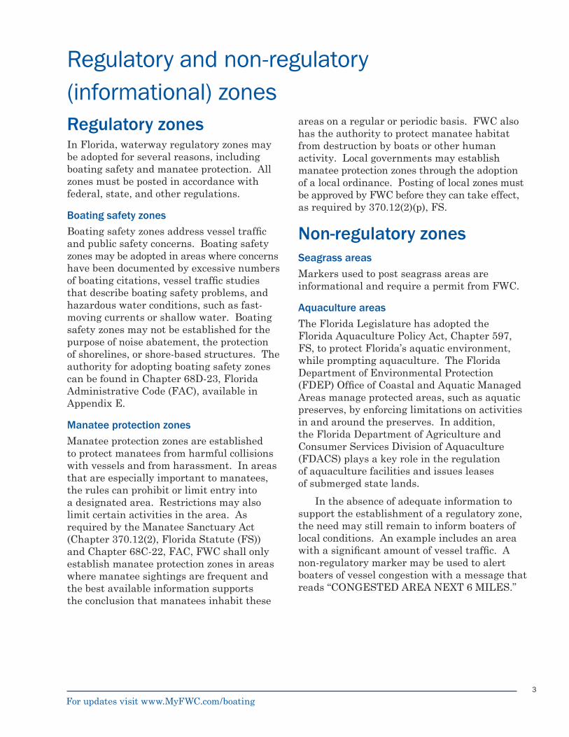
Regulatory and non-regulatory (informational) zonesRegulatory zonesIn Florida, waterway regulatory zones may be adopted for several reasons, including boating safety and manatee protection. All zones must be posted in accordance with federal, state, and other regulations.
Boating safety zonesBoating safety zones address vessel traffi c and public safety concerns. Boating safety zones may be adopted in areas where concerns have been documented by excessive numbers of boating citations, vessel traffi c studies that describe boating safety problems, and hazardous water conditions, such as fast-moving currents or shallow water. Boating safety zones may not be established for the purpose of noise abatement, the protection of shorelines, or shore-based structures. The authority for adopting boating safety zones can be found in Chapter 68D-23, Florida Administrative Code (FAC), available in Appendix E.
Manatee protection zonesManatee protection zones are established to protect manatees from harmful collisions with vessels and from harassment. In areas that are especially important to manatees, the rules can prohibit or limit entry into a designated area. Restrictions may also limit certain activities in the area. As required by the Manatee Sanctuary Act (Chapter 370.12(2), Florida Statute (FS)) and Chapter 68C-22, FAC, FWC shall only establish manatee protection zones in areas where manatee sightings are frequent and the best available information supports the conclusion that manatees inhabit these
areas on a regular or periodic basis. FWC also has the authority to protect manatee habitat from destruction by boats or other human activity. Local governments may establish manatee protection zones through the adoption of a local ordinance. Posting of local zones must be approved by FWC before they can take effect, as required by 370.12(2)(p), FS.
Non-regulatory zonesSeagrass areasMarkers used to post seagrass areas are informational and require a permit from FWC.
Aquaculture areasThe Florida Legislature has adopted the Florida Aquaculture Policy Act, Chapter 597, FS, to protect Florida’s aquatic environment, while prompting aquaculture. The Florida Department of Environmental Protection (FDEP) Offi ce of Coastal and Aquatic Managed Areas manage protected areas, such as aquatic preserves, by enforcing limitations on activities in and around the preserves. In addition, the Florida Department of Agriculture and Consumer Services Division of Aquaculture (FDACS) plays a key role in the regulation of aquaculture facilities and issues leases of submerged state lands.
In the absence of adequate information to support the establishment of a regulatory zone, the need may still remain to inform boaters of local conditions. An example includes an area with a signifi cant amount of vessel traffi c. A non-regulatory marker may be used to alert boaters of vessel congestion with a message that reads “CONGESTED AREA NEXT 6 MILES.”
4
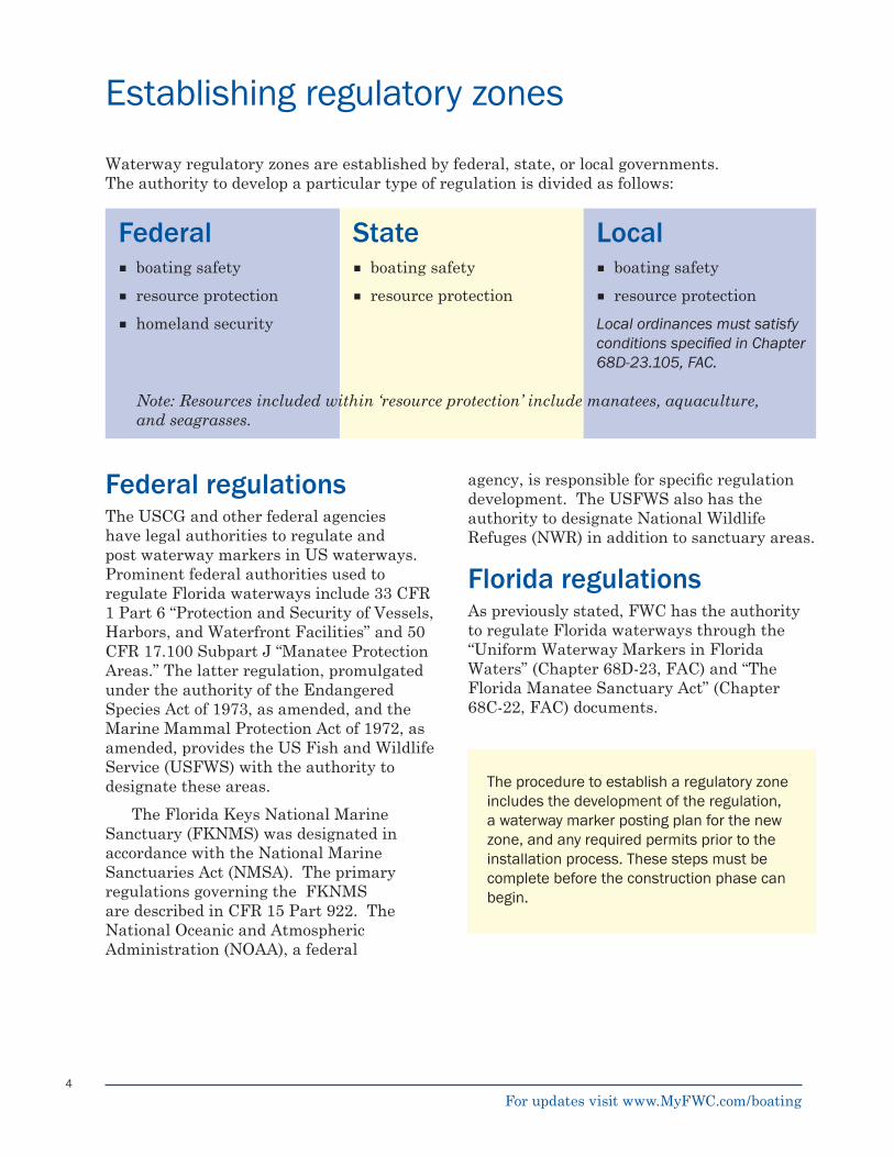
Waterway regulatory zones are established by federal, state, or local governments. The authority to develop a particular type of regulation is divided as follows:
Federal State Localboating safetyresource protectionhomeland security
■
■
■
boating safetyresource protection
■
■
boating safetyresource protection
Local ordinances must satisfy conditions specifi ed in Chapter 68D-23.105, FAC.
■
■
Federal regulations The USCG and other federal agencies have legal authorities to regulate and post waterway markers in US waterways. Prominent federal authorities used to regulate Florida waterways include 33 CFR 1 Part 6 “Protection and Security of Vessels, Harbors, and Waterfront Facilities” and 50 CFR 17.100 Subpart J “Manatee Protection Areas.” The latter regulation, promulgated under the authority of the Endangered Species Act of 1973, as amended, and the Marine Mammal Protection Act of 1972, as amended, provides the US Fish and Wildlife Service (USFWS) with the authority to designate these areas.
The Florida Keys National Marine Sanctuary (FKNMS) was designated in accordance with the National Marine Sanctuaries Act (NMSA). The primary regulations governing the FKNMS are described in CFR 15 Part 922. The National Oceanic and Atmospheric Administration (NOAA), a federal
The procedure to establish a regulatory zone includes the development of the regulation, a waterway marker posting plan for the new zone, and any required permits prior to the installation process. These steps must be complete before the construction phase can begin.
agency, is responsible for specifi c regulation development. The USFWS also has the authority to designate National Wildlife Refuges (NWR) in addition to sanctuary areas.
Florida regulations As previously stated, FWC has the authority to regulate Florida waterways through the “Uniform Waterway Markers in Florida Waters” (Chapter 68D-23, FAC) and “The Florida Manatee Sanctuary Act” (Chapter 68C-22, FAC) documents.
Note: Resources included within ‘resource protection’ include manatees, aquaculture, and seagrasses.
For updates visit www.MyFWC.com/boating
Establishing regulatory zones
5
FDEP has the authority to regulate Florida waterways through the Florida Aquaculture Policy Act (Chapter 597, FS) and can also regulate waters within their jurisdiction at parks (i.e. bathing areas) as provided in 62D-2.014, FAC.
Local government regulationsCounties and local municipalities have the authority to regulate vessel traffi c on a local level pursuant to Chapter 68D-23, FAC and sections 327.40, 327.60, and 370.12 (2), FS. However, all waterway markers posted in state waters are required to be permitted. Informational markers placed by counties, municipalities, or other governmental entities on inland lakes and their associated canals are exempt from permitting. Please refer to Rule 68D-23.112, FAC for other permitting exemptions.
Developing regulationsWhen developing new regulations, it is important to consider assessing impacts the proposed rule may have on existing regulations, including markers (aids to navigation) already in place and existing navigational hazards. Waterway marker plans developed to support new regulations must take into account any impediments that make marking the zone diffi cult and any elements that may make the marked area confusing to the public or diffi cult to enforce. Plans should be adjusted to address these concerns; on occasion, existing regulations and markers may be modifi ed to support new regulations.
When marking zones, two objectives must be met:Provide a clear understanding of the regulations and boundaries of the regulated area. The public must reasonably understand what is required of them.Mark the zone to enable the enforcement of the regulation. Include the rule or ordinance number on all markers.
1.
2.
PermittingAll markers placed in Florida waters (with the exception of markers placed in inland lakes and associated canals) must be approved and permitted by federal and state authorities.
The US Army Corps of Engineers (USACE) is the federal permitting agency and the state water management districts and FDEP provide state permits, as appropriate. For lighted markers, a USCG permit will also be needed. See What You Should Know About Permitting on page 22. In addition, coordination with the USCG is required to ensure that markers comply with federal requirements pertaining to design, size, message, and symbol, as well as ensuring that the proposed installation location does not present an undue hazard to navigation. When posted, all regulatory markers will display a permit number on the sign face or buoy; these numbers are used for the purpose of identifying individual markers in FWC’s statewide marker inventory database. Permitting of regulatory waterway markers is discussed in detail later in this document.
Waterway marker plan A draft waterway marker plan is an important step in the regulation development process. Evaluation of the area to be regulated must be identifi ed in terms of what needs to be regulated (boating safety, manatee protection, etc.), the geography of the area, existing regulations, water conditions, and other factors. After evaluating these factors, a draft waterway marker plan must be developed that outlines the boundaries of the area to be regulated, including marker placement location, descriptions of marker message types, types of markers, and so on. A waterway marker plan is generally drafted by the parties developing the regulation and should include input from permitting agencies, local waterway authorities, the boating public, and others.
For updates visit www.MyFWC.com/boating
6
The design of a waterway marker plan to post regulatory zones will depend on a variety of factors including:
The geographic boundaries of the regulationPhysical features of the area to be markedWater conditions (including depth and substrate)Existing markers, traffi c patterns, and access points, such as marinas and ramp facilitiesInterfaces, transitions, and confl icts with other regulated zonesLimitations to installation and maintenance of the markers and their associated structures, such as existing utility linesNavigational charts, aerial photographs, and other sources of information are used as aids to identify the type and location of these factors.
A waterway marker plan, consistent with permitting requirements, includes the following features:
A scale drawing of the regulated area (not to exceed 8.5 x 11l l) showing the approximate placement of markersA corresponding list or table describing the details of each marker:Marker type (sign or buoy)Marker size, shape, color, and materialHeight above mean high water (for signs, measured to bottom edge)Message (including lettering and numbering)Global positioning system (GPS) coordinates in degrees and decimal minutesA statement of purpose that includes:
Justifi cation for regulating the areaA copy of the adopted ordinance(s)Names of the entities who will be responsible for the upkeep and maintenance of the marker(s)Waterway marker plan development requires close coordination
with all affected entities and stakeholders, including local, state, and federal marine law enforcement offi ces. Because marine law enforcement staff are most familiar with the areas where they conduct enforcement activities, their input is very important to proper placement of markers. Other stakeholder input should also be included in the development of plans. Other stakeholders may include boat operators, marine industries, and other waterway experts.
1.2.3.4.
5.6.
7.
■
■
■
■
■
■
■
■
•••
For updates visit www.MyFWC.com/boating
7
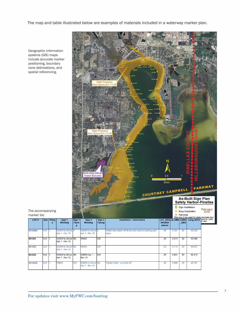
Geographic information systems (GIS) maps include accurate marker positioning, boundary zone delineations, and spatial referencing.
The accompanying marker list.
The map and table illustrated below are examples of materials included in a waterway marker plan.
For updates visit www.MyFWC.com/boating
8
PERMIT NO.: 91-000
BOATING SAFETY ZONE
IDLESPEED
NO WAKE68D-23.XXX FAC
PERMIT NO.: 91-000
MANATEE ZONE
SLOWSPEED
MINIMUM WAKE68C-22.XXX FAC
Regulatory zonesState and local government boating safety zones must satisfy the criteria established in Rule 68D-23.105, FAC. State manatee protection zones are established pursuant to the criteria set forth in Section 270.12(2) FS. Local governments that wish to adopt an ordinance for manatee protection must follow the criteria established in Section 270.12(2)(p) FS. Regardless of the type, the regulations generally employ the following types of zones:
Idle speed no wakeSlow speed minimum wakeMaximum XX miles per hour (MPH)Restricted/limited entry
Idle speed no wake
■
■
■
■
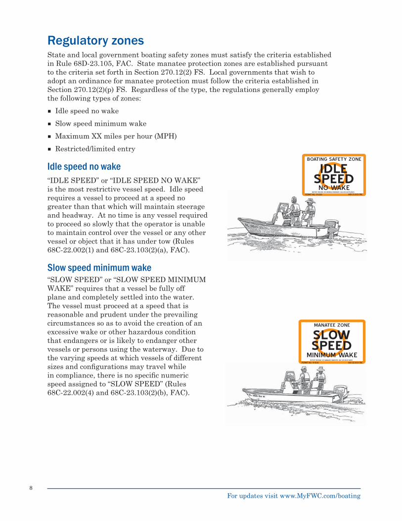
“IDLE SPEED” or “IDLE SPEED NO WAKE” is the most restrictive vessel speed. Idle speed requires a vessel to proceed at a speed no greater than that which will maintain steerage and headway. At no time is any vessel required to proceed so slowly that the operator is unable to maintain control over the vessel or any other vessel or object that it has under tow (Rules 68C-22.002(1) and 68C-23.103(2)(a), FAC).
Slow speed minimum wake“SLOW SPEED” or “SLOW SPEED MINIMUM WAKE” requires that a vessel be fully off plane and completely settled into the water. The vessel must proceed at a speed that is reasonable and prudent under the prevailing circumstances so as to avoid the creation of an excessive wake or other hazardous condition that endangers or is likely to endanger other vessels or persons using the waterway. Due to the varying speeds at which vessels of different sizes and confi gurations may travel while in compliance, there is no specifi c numeric speed assigned to “SLOW SPEED” (Rules 68C-22.002(4) and 68C-23.103(2)(b), FAC).
REPORT MISSING OR DAMAGED MARKERS: 866-405-BUOY(2869)
REPORT MISSING OR DAMAGED MARKERS: 866-405-BUOY(2869)
For updates visit www.MyFWC.com/boating
9
PERMIT NO.: 91-000
BOATING SAFETY ZONE
25MPH
IN CHANNEL68D-23.XXX FAC
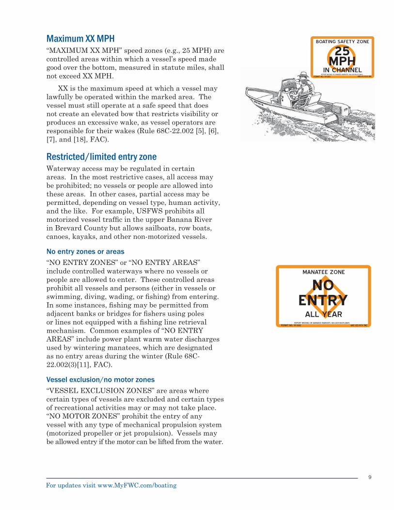
Maximum XX MPH“MAXIMUM XX MPH” speed zones (e.g., 25 MPH) are controlled areas within which a vessel’s speed made good over the bottom, measured in statute miles, shall not exceed XX MPH.
XX is the maximum speed at which a vessel may lawfully be operated within the marked area. The vessel must still operate at a safe speed that does not create an elevated bow that restricts visibility or produces an excessive wake, as vessel operators are responsible for their wakes (Rule 68C-22.002 [5], [6], [7], and [18], FAC).
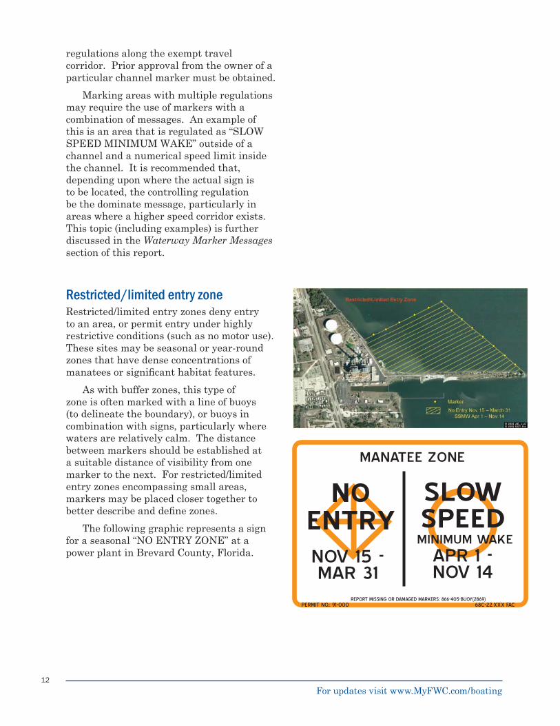
Restricted/limited entry zoneWaterway access may be regulated in certain areas. In the most restrictive cases, all access may be prohibited; no vessels or people are allowed into these areas. In other cases, partial access may be permitted, depending on vessel type, human activity, and the like. For example, USFWS prohibits all motorized vessel traffi c in the upper Banana River in Brevard County but allows sailboats, row boats, canoes, kayaks, and other non-motorized vessels.
No entry zones or areas“NO ENTRY ZONES” or “NO ENTRY AREAS” include controlled waterways where no vessels or people are allowed to enter. These controlled areas prohibit all vessels and persons (either in vessels or swimming, diving, wading, or fi shing) from entering. In some instances, fi shing may be permitted from adjacent banks or bridges for fi shers using poles or lines not equipped with a fi shing line retrieval mechanism. Common examples of “NO ENTRY AREAS” include power plant warm water discharges used by wintering manatees, which are designated as no entry areas during the winter (Rule 68C-22.002(3)[11], FAC).
Vessel exclusion/no motor zones“VESSEL EXCLUSION ZONES” are areas where certain types of vessels are excluded and certain types of recreational activities may or may not take place. “NO MOTOR ZONES” prohibit the entry of any vessel with any type of mechanical propulsion system (motorized propeller or jet propulsion). Vessels may be allowed entry if the motor can be lifted from the water.
PERMIT NO.: 91-000 68C-22.XXX FAC
MANATEE ZONE
NOENTRY
ALL YEARREPORT MISSING OR DAMAGED MARKERS: 866-405-BUOY(2869)
REPORT MISSING OR DAMAGED MARKERS: 866-405-BUOY(2869)
For updates visit www.MyFWC.com/boating
10
Regulatory zone confi gurationsRegulatory zones may be categorized into four basic confi gurations:
Shore-to-Shore ZonesBuffer ZonesTravel Corridor ZonesRestricted/Limited Entry Zones
■
■
■
■
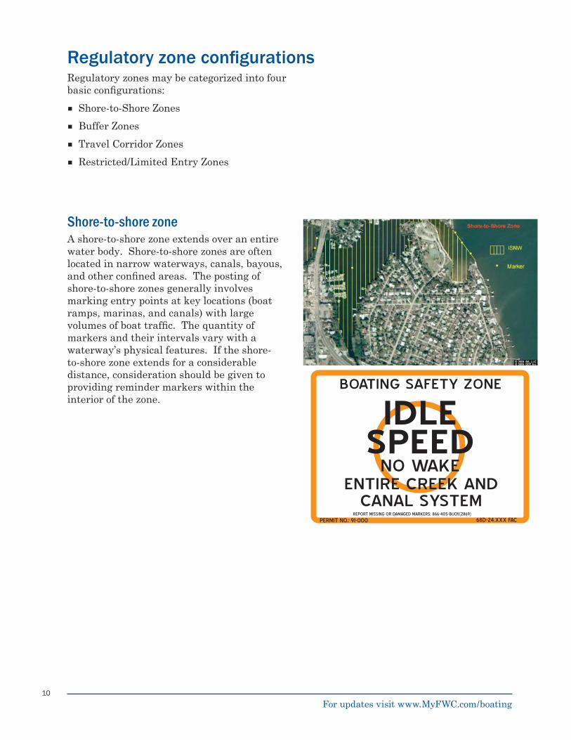
Shore-to-shore zoneA shore-to-shore zone extends over an entire water body. Shore-to-shore zones are often located in narrow waterways, canals, bayous, and other confi ned areas. The posting of shore-to-shore zones generally involves marking entry points at key locations (boat ramps, marinas, and canals) with large volumes of boat traffi c. The quantity of markers and their intervals vary with a waterway’s physical features. If the shore-to-shore zone extends for a considerable distance, consideration should be given to providing reminder markers within the interior of the zone.
BOATING SAFETY ZONE
IDLENO WAKE
ENTIRE CREEK AND CANAL SYSTEM
PERMIT NO.: 91-000 68D-24.XXX FAC
SPEED
REPORT MISSING OR DAMAGED MARKERS: 866-405-BUOY(2869)
For updates visit www.MyFWC.com/boating
11
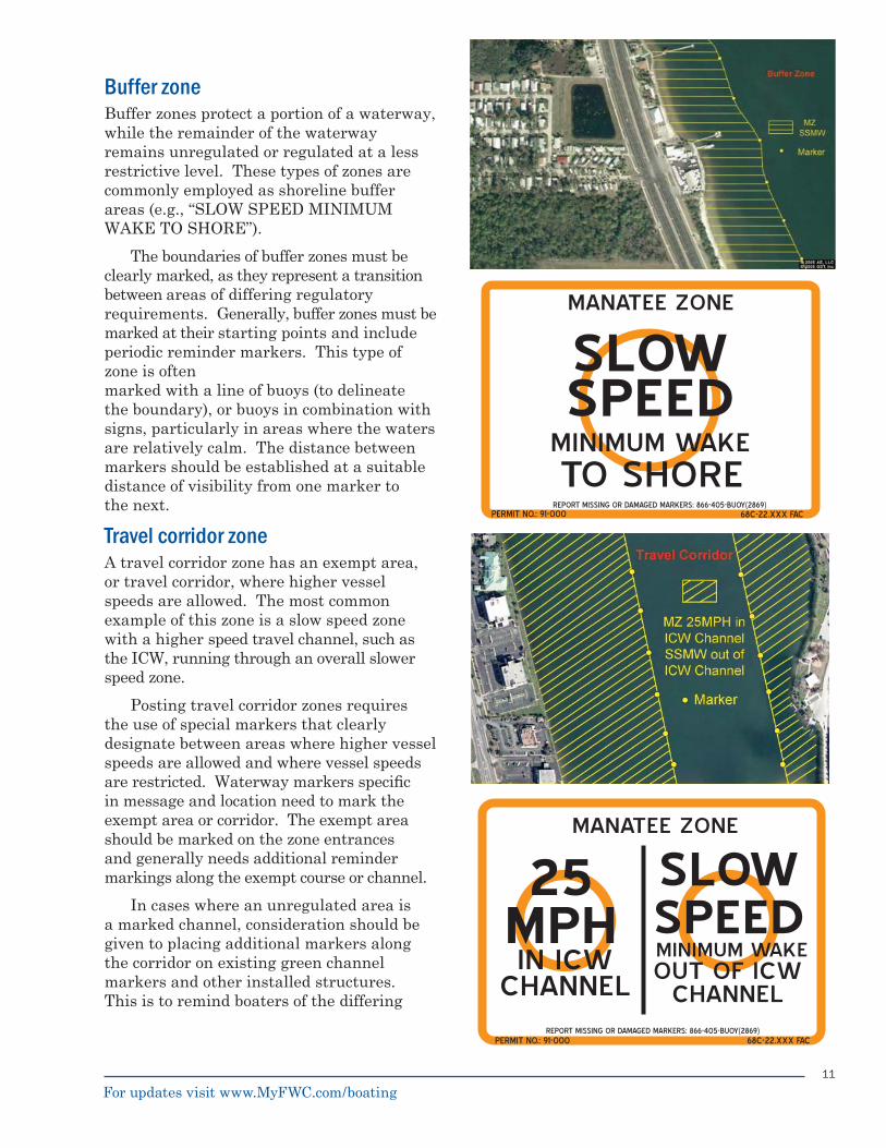
Travel corridor zoneA travel corridor zone has an exempt area, or travel corridor, where higher vessel speeds are allowed. The most common example of this zone is a slow speed zone with a higher speed travel channel, such as the ICW, running through an overall slower speed zone.
Posting travel corridor zones requires the use of special markers that clearly designate between areas where higher vessel speeds are allowed and where vessel speeds are restricted. Waterway markers specifi c in message and location need to mark the exempt area or corridor. The exempt area should be marked on the zone entrances and generally needs additional reminder markings along the exempt course or channel.
In cases where an unregulated area is a marked channel, consideration should be given to placing additional markers along the corridor on existing green channel markers and other installed structures. This is to remind boaters of the differing
Buffer zoneBuffer zones protect a portion of a waterway, while the remainder of the waterway remains unregulated or regulated at a less restrictive level. These types of zones are commonly employed as shoreline buffer areas (e.g., “SLOW SPEED MINIMUM WAKE TO SHORE”).
The boundaries of buffer zones must be clearly marked, as they represent a transition between areas of differing regulatory requirements. Generally, buffer zones must be marked at their starting points and include periodic reminder markers. This type of zone is oftenmarked with a line of buoys (to delineate the boundary), or buoys in combination with signs, particularly in areas where the waters are relatively calm. The distance between markers should be established at a suitable distance of visibility from one marker to the next.
MANATEE ZONE
SLOW
MINIMUM WAKETO SHORE
PERMIT NO.: 91-000 68C-22.XXX FAC
SPEED
REPORT MISSING OR DAMAGED MARKERS: 866-405-BUOY(2869)
PERMIT NO.: 91-000
MANATEE ZONE
25 MPHIN ICW
CHANNEL
SLOW SPEEDMINIMUM WAKEOUT OF ICW
CHANNELREPORT MISSING OR DAMAGED MARKERS: 866-405-BUOY(2869)
68C-22.XXX FAC
For updates visit www.MyFWC.com/boating
12
regulations along the exempt travel corridor. Prior approval from the owner of a particular channel marker must be obtained.
Marking areas with multiple regulations may require the use of markers with a combination of messages. An example of this is an area that is regulated as “SLOW SPEED MINIMUM WAKE” outside of a channel and a numerical speed limit inside the channel. It is recommended that, depending upon where the actual sign is to be located, the controlling regulation be the dominate message, particularly in areas where a higher speed corridor exists. This topic (including examples) is further discussed in the Waterway Marker Messages section of this report.
Restricted/limited entry zoneRestricted/limited entry zones deny entry to an area, or permit entry under highly restrictive conditions (such as no motor use). These sites may be seasonal or year-round zones that have dense concentrations of manatees or signifi cant habitat features.
As with buffer zones, this type of zone is often marked with a line of buoys (to delineate the boundary), or buoys in combination with signs, particularly where waters are relatively calm. The distance between markers should be established at a suitable distance of visibility from one marker to the next. For restricted/limited entry zones encompassing small areas, markers may be placed closer together to better describe and defi ne zones.
The following graphic represents a sign for a seasonal “NO ENTRY ZONE” at a power plant in Brevard County, Florida.
MANATEE ZONE
NO ENTRYNOV 15 -MAR 31
PERMIT NO.: 91-000 68C-22.XXX FAC
SLOW SPEEDMINIMUM WAKE
APR 1 -NOV 14
REPORT MISSING OR DAMAGED MARKERS: 866-405-BUOY(2869)
For updates visit www.MyFWC.com/boating
13
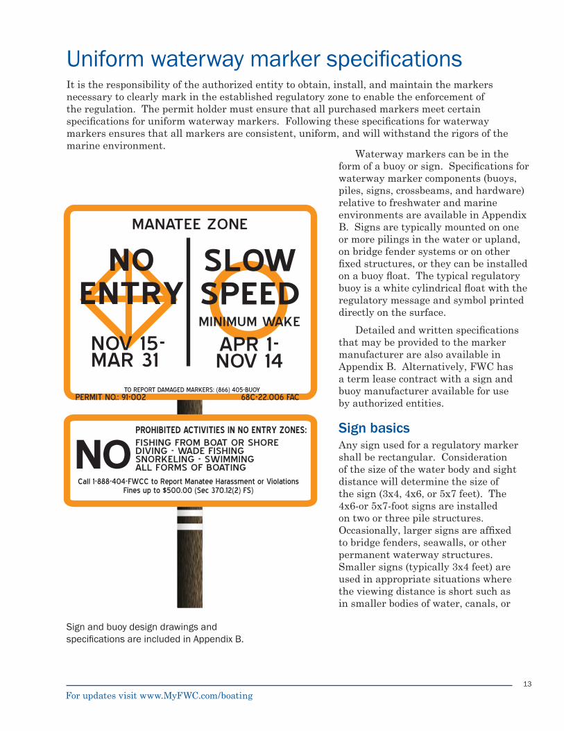
It is the responsibility of the authorized entity to obtain, install, and maintain the markers necessary to clearly mark in the established regulatory zone to enable the enforcement of the regulation. The permit holder must ensure that all purchased markers meet certain specifi cations for uniform waterway markers. Following these specifi cations for waterway markers ensures that all markers are consistent, uniform, and will withstand the rigors of the marine environment.
Uniform waterway marker specifi cations
MANATEE ZONE
NO ENTRY
NOV 15- MAR 31
PERMIT NO.: 91-002 68C-22.006 FAC
SLOW SPEEDMINIMUM WAKE
APR 1- NOV 14
TO REPORT DAMAGED MARKERS: (866) 405-BUOY
NOPROHIBITED ACTIVITIES IN NO ENTRY ZONES:FISHING FROM BOAT OR SHOREDIVING - WADE FISHINGSNORKELING - SWIMMINGALL FORMS OF BOATING
Call 1-888-404-FWCC to Report Manatee Harassment or ViolationsFines up to $500.00 (Sec 370.12(2) FS)
Waterway markers can be in the form of a buoy or sign. Specifi cations for waterway marker components (buoys, piles, signs, crossbeams, and hardware) relative to freshwater and marine environments are available in Appendix B. Signs are typically mounted on one or more pilings in the water or upland, on bridge fender systems or on other fi xed structures, or they can be installed on a buoy fl oat. The typical regulatory buoy is a white cylindrical fl oat with the regulatory message and symbol printed directly on the surface.
Detailed and written specifi cations that may be provided to the marker manufacturer are also available in Appendix B. Alternatively, FWC has a term lease contract with a sign and buoy manufacturer available for use by authorized entities.
Sign basicsAny sign used for a regulatory marker shall be rectangular. Consideration of the size of the water body and sight distance will determine the size of the sign (3x4, 4x6, or 5x7 feet). The 4x6-or 5x7-foot signs are installed on two or three pile structures. Occasionally, larger signs are affi xed to bridge fenders, seawalls, or other permanent waterway structures. Smaller signs (typically 3x4 feet) are used in appropriate situations where the viewing distance is short such as in smaller bodies of water, canals, or
Sign and buoy design drawings and specifi cations are included in Appendix B.
For updates visit www.MyFWC.com/boating
14
boat ramps. The smaller 3x4 signs are often used in conjunction with other similarly sized ATONS (green channel markers). An additional sign (generally 1x4, 1x6, or 1x7 feet) may be placed below the regulatory sign to clarify the intent of the message or to reduce the amount of text on a sign (see illustration on previous page and Appendix A for examples).
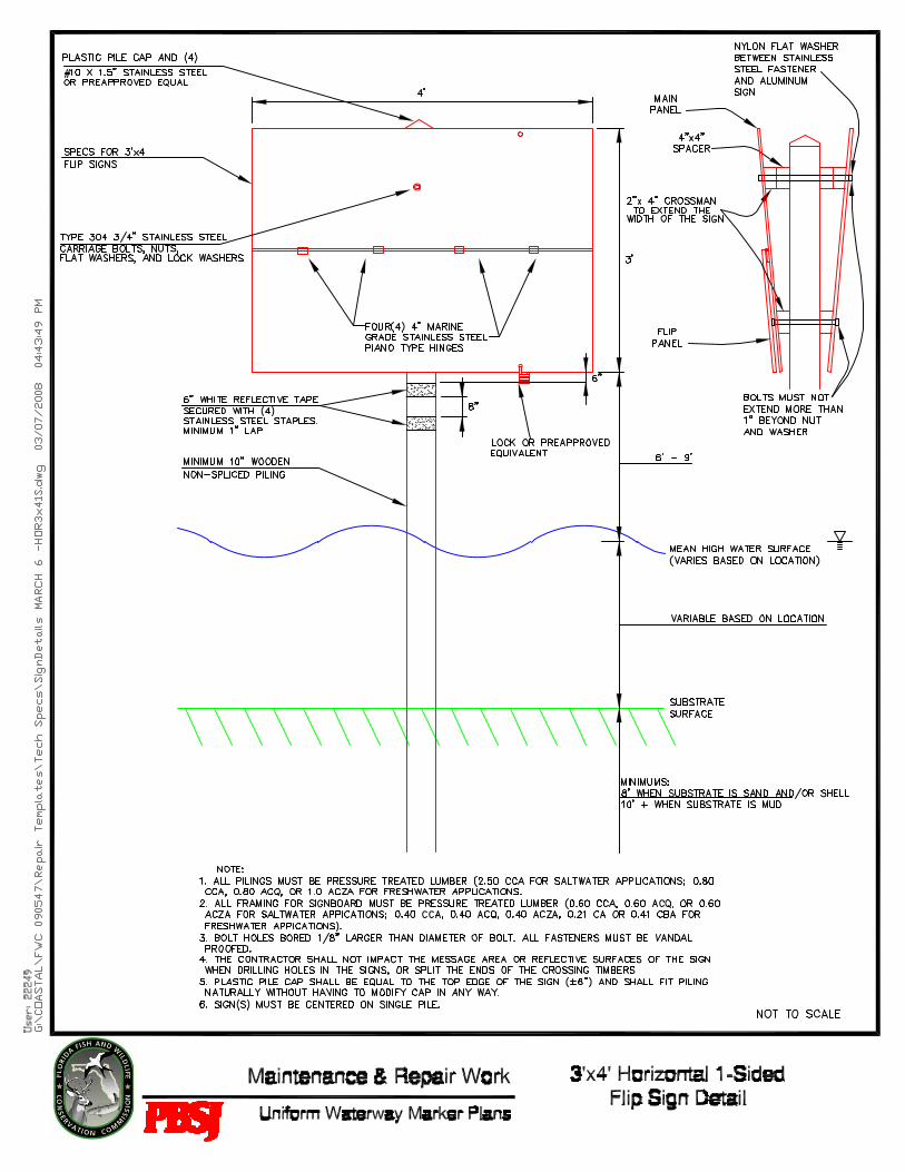
Flip signs (vertical or horizontal) have been used effectively for some time to indicate a seasonal change in waterway regulations. The most common use of fl ip signs exist where the zone changes twice a year, such as within Blue Waters (Citrus County) where there is a seasonal “NO ENTRY” regulation, and within Blue Springs State Park (Volusia County): “SLOW SPEED MINIMUM WAKE CHANNEL INCLUDED OCTOBER 15 – APRIL 15 and 25 MPH IN CHANNEL APRIL 16 – OCTOBER 14.” See Appendix A for an example of fl ip sign mechanics.
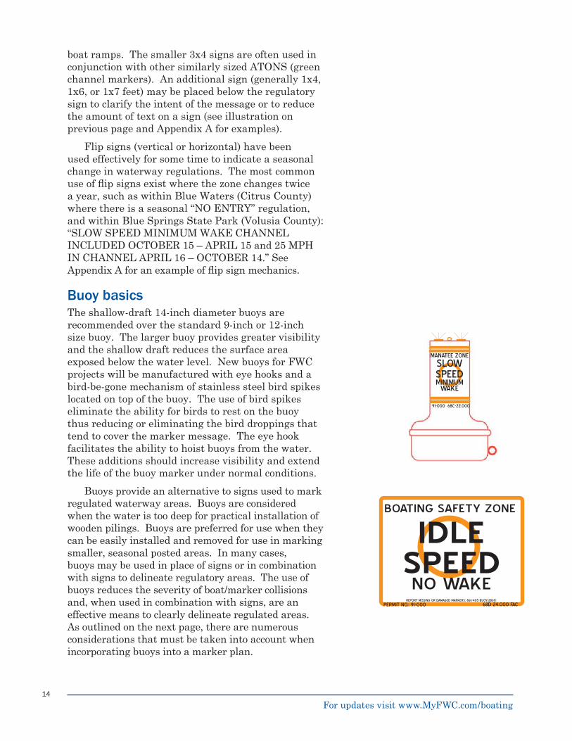
Buoy basicsThe shallow-draft 14-inch diameter buoys are recommended over the standard 9-inch or 12-inch size buoy. The larger buoy provides greater visibility and the shallow draft reduces the surface area exposed below the water level. New buoys for FWC projects will be manufactured with eye hooks and a bird-be-gone mechanism of stainless steel bird spikes located on top of the buoy. The use of bird spikes eliminate the ability for birds to rest on the buoy thus reducing or eliminating the bird droppings that tend to cover the marker message. The eye hook facilitates the ability to hoist buoys from the water. These additions should increase visibility and extend the life of the buoy marker under normal conditions.
Buoys provide an alternative to signs used to mark regulated waterway areas. Buoys are considered when the water is too deep for practical installation of wooden pilings. Buoys are preferred for use when they can be easily installed and removed for use in marking smaller, seasonal posted areas. In many cases, buoys may be used in place of signs or in combination with signs to delineate regulatory areas. The use of buoys reduces the severity of boat/marker collisions and, when used in combination with signs, are an effective means to clearly delineate regulated areas. As outlined on the next page, there are numerous considerations that must be taken into account when incorporating buoys into a marker plan.
PERMIT NO.: 91-000 68D-24.000 FAC
BOATING SAFETY ZONE
IDLESPEEDNO WAKE
SLOWSPEEDMINIMUM
WAKE
MANATEE ZONE
91-000 68C-22.000
REPORT MISSING OR DAMAGED MARKERS: 866-405-BUOY(2869)
For updates visit www.MyFWC.com/boating
15
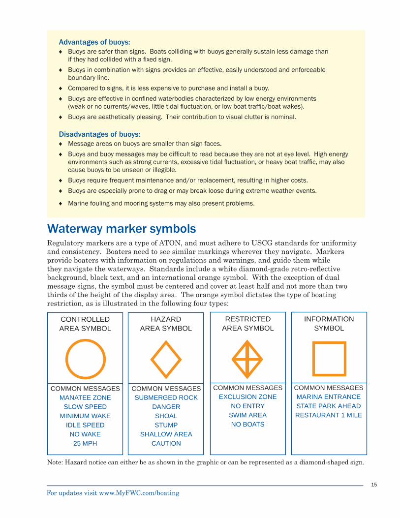
CONTROLLED AREA SYMBOL
HAZARD AREA SYMBOL
RESTRICTED AREA SYMBOL
INFORMATION SYMBOL
COMMON MESSAGESMANATEE ZONE
SLOW SPEEDMINIMUM WAKE
IDLE SPEEDNO WAKE
25 MPH
COMMON MESSAGESSUBMERGED ROCK
DANGERSHOALSTUMP
SHALLOW AREACAUTION
COMMON MESSAGESEXCLUSION ZONE
NO ENTRYSWIM AREANO BOATS
COMMON MESSAGESMARINA ENTRANCESTATE PARK AHEADRESTAURANT 1 MILE
Waterway marker symbolsRegulatory markers are a type of ATON, and must adhere to USCG standards for uniformity and consistency. Boaters need to see similar markings wherever they navigate. Markers provide boaters with information on regulations and warnings, and guide them while they navigate the waterways. Standards include a white diamond-grade retro-refl ective background, black text, and an international orange symbol. With the exception of dual message signs, the symbol must be centered and cover at least half and not more than two thirds of the height of the display area. The orange symbol dictates the type of boating restriction, as is illustrated in the following four types:
Advantages of buoys:Buoys are safer than signs. Boats colliding with buoys generally sustain less damage than if they had collided with a fi xed sign.
Buoys in combination with signs provides an effective, easily understood and enforceable boundary line.
Compared to signs, it is less expensive to purchase and install a buoy.
Buoys are effective in confi ned waterbodies characterized by low energy environments (weak or no currents/waves, little tidal fl uctuation, or low boat traffi c/boat wakes).
Buoys are aesthetically pleasing. Their contribution to visual clutter is nominal.
Disadvantages of buoys:Message areas on buoys are smaller than sign faces.
Buoys and buoy messages may be diffi cult to read because they are not at eye level. High energy environments such as strong currents, excessive tidal fl uctuation, or heavy boat traffi c, may also cause buoys to be unseen or illegible.
Buoys require frequent maintenance and/or replacement, resulting in higher costs.
Buoys are especially prone to drag or may break loose during extreme weather events.
Marine fouling and mooring systems may also present problems.
♦
♦
♦
♦
♦
♦
♦
♦
♦
♦
Note: Hazard notice can either be as shown in the graphic or can be represented as a diamond-shaped sign.
For updates visit www.MyFWC.com/boating
16
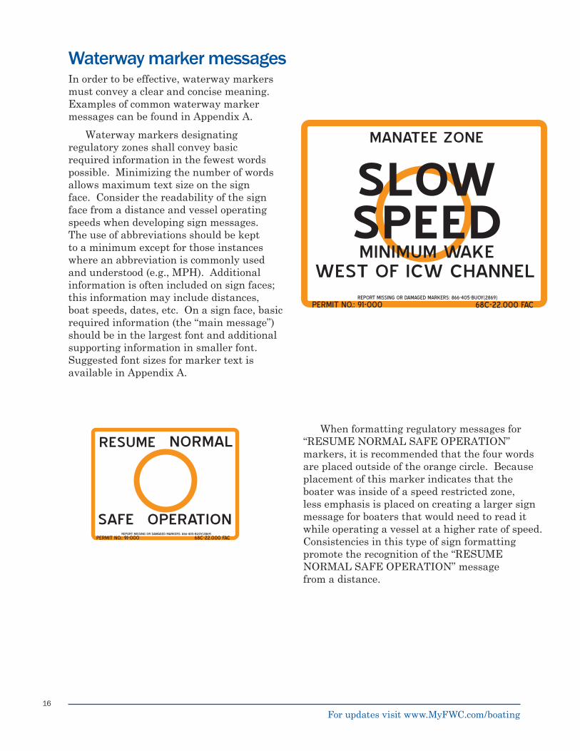
Waterway marker messagesIn order to be effective, waterway markers must convey a clear and concise meaning. Examples of common waterway marker messages can be found in Appendix A.
Waterway markers designating regulatory zones shall convey basic required information in the fewest words possible. Minimizing the number of words allows maximum text size on the sign face. Consider the readability of the sign face from a distance and vessel operating speeds when developing sign messages. The use of abbreviations should be kept to a minimum except for those instances where an abbreviation is commonly used and understood (e.g., MPH). Additional information is often included on sign faces; this information may include distances, boat speeds, dates, etc. On a sign face, basic required information (the “main message”) should be in the largest font and additional supporting information in smaller font. Suggested font sizes for marker text is available in Appendix A.
When formatting regulatory messages for “RESUME NORMAL SAFE OPERATION” markers, it is recommended that the four words are placed outside of the orange circle. Because placement of this marker indicates that the boater was inside of a speed restricted zone, less emphasis is placed on creating a larger sign message for boaters that would need to read it while operating a vessel at a higher rate of speed. Consistencies in this type of sign formatting promote the recognition of the “RESUME NORMAL SAFE OPERATION” message from a distance.
PERMIT NO.: 91-000 68C-22.000 FAC
MANATEE ZONE
SLOWSPEEDMINIMUM WAKE
WEST OF ICW CHANNEL
PERMIT NO.: 91-000 68C-22.000 FAC
RESUME
SAFE OPERATION
NORMAL
REPORT MISSING OR DAMAGED MARKERS: 866-405-BUOY(2869)
REPORT MISSING OR DAMAGED MARKERS: 866-405-BUOY(2869)
For updates visit www.MyFWC.com/boating
17
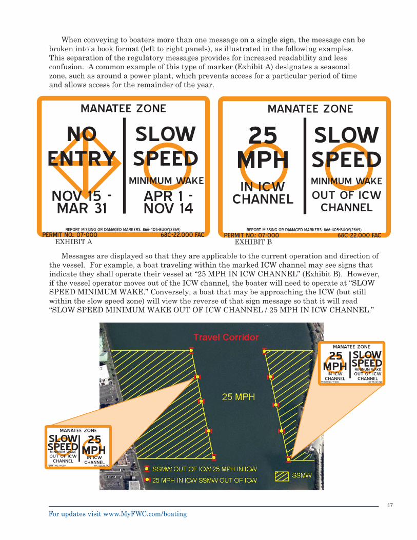
Messages are displayed so that they are applicable to the current operation and direction of the vessel. For example, a boat traveling within the marked ICW channel may see signs that indicate they shall operate their vessel at “25 MPH IN ICW CHANNEL” (Exhibit B). However, if the vessel operator moves out of the ICW channel, the boater will need to operate at “SLOW SPEED MINIMUM WAKE.” Conversely, a boat that may be approaching the ICW (but still within the slow speed zone) will view the reverse of that sign message so that it will read “SLOW SPEED MINIMUM WAKE OUT OF ICW CHANNEL / 25 MPH IN ICW CHANNEL.”
When conveying to boaters more than one message on a single sign, the message can be broken into a book format (left to right panels), as illustrated in the following examples. This separation of the regulatory messages provides for increased readability and less confusion. A common example of this type of marker (Exhibit A) designates a seasonal zone, such as around a power plant, which prevents access for a particular period of time and allows access for the remainder of the year.
PERMIT NO.: 91-000
MANATEE ZONE
25MPH
IN ICWCHANNEL
68C-22.XXX FAC
SLOWSPEEDOUT OF ICW
CHANNEL
MINIMUM WAKE
PERMIT NO.: 91-000
MANATEE ZONE
25MPH
IN ICWCHANNEL
68C-22.XXX FAC
SLOWSPEEDOUT OF ICW
CHANNEL
MINIMUM WAKE
MANATEE ZONE
25 MPHIN ICW
CHANNEL
PERMIT NO.: 07-000 68C-22.000 FAC
SLOW SPEEDMINIMUM WAKE
OUT OF ICWCHANNEL
EXHIBIT B
REPORT MISSING OR DAMAGED MARKERS: 866-405-BUOY(2869)
EXHIBIT A
MANATEE ZONE
NOV 15 - MAR 31
PERMIT NO.: 07-000 68C-22.000 FAC
SLOW SPEED
MINIMUM WAKE
APR 1 - NOV 14
NO ENTRY
REPORT MISSING OR DAMAGED MARKERS: 866-405-BUOY(2869)
For updates visit www.MyFWC.com/boating
18
As previously discussed, additional sign messages can be placed on a marker to reduce the amount of text on the regulatory sign. Use of this method allows for a standard message on the upper sign, with additional information conveyed on the sign placed below.
Placement of the permit number and regulationsThe permit number must be displayed in the lower left corner of each waterway marker. Applicable references to code sections, statutes, or regulation numbers must be displayed in the lower right corner. Both the rule and permit numbers shall be in black block characters not less than one inch in height (provided that it does not interfere with the message of the marker). The toll-free number to report navigational hazards to the On-Call Response program, described later in this document, can be placed between the permit and rule numbers if desired.
A permit and regulation (rule, ordinance, or CFR) number is placed on all signs for the purposes of tracking in the statewide database, and for the enforcement of the specifi c regulation. For all markers other than regulatory markers, the permit number shall be displayed on the marker in any location. Because informational markers placed by counties, municipalities, and other governmental entities on inland lakes and their associated canals are exempt from permitting, the markers must displaythe name of the owner of the marker (in lieu of a permit number). In a few areas of the state, there are overlapping state, federal, and/or local government boating restricted regulations. In these cases, the signs display all applicable state regulations, federal regulations, and/or local government ordinances.
PERMIT NO.: 91-000 68C-22.000 FAC
MANATEE ZONE
SLOWSPEEDMINIMUM WAKE
50CFR 17.108
SLOWSPEEDMINIMUM
WAKE
MANATEE ZONE
91-000 68C-22.000
PERMIT
RULE
For updates visit www.MyFWC.com/boating
19
Marker placement guidelinesThere are a wide variety of waterway marker plan confi gurations. Some amount of customizing may be needed for each zone to be properly and adequately posted. General guidelines that apply to the posting of all regulatory zones include:
Planning and placement of waterway markers
The marine contractor must contact Sunshine Utilities (1-800-432-4770) prior to the commencement of construction.Zone boundary lines should be posted such that boaters are able to see from marker to marker from both perpendicular and parallel perspectives. Signifi cant angles and changes in direction should be delineated with markers. If physical features, such as land masses, bridges, creek and canal mouths, channels, and other readily identifi able landscape references are used in the marking scheme, ensure that the boundary lines are tied into these features with the marker messages (e.g., “SLOW SPEED MINIMUM WAKE TO BRIDGE” or “SLOW SPEED MINIMUM WAKE 500 FEET TO SHORE”). Transitional areas between zones and unregulated or higher speed areas within zones need to be clearly differentiated from the regulated zone (e.g., “RESUME NORMAL SAFE OPERATION” or “SLOW SPEED MINIMUM WAKE OUT OF MARKED CHANNEL / 25 MPH IN MARKED CHANNEL”).Markers appropriate to the area should be used. For example, where buoys can provide additional safety for boaters, they should be installed. Buoys may be used by themselves to mark a shoreline buffer zone or in combination with signs. Postings should be coordinated with existing waterway markers/features/regulations to minimize confusion and visual clutter as well as to minimize hazards to navigation. The use of existing bridge fender systems, bridge pilings, power poles, and ATONs should be considered as alternatives to additional pilings. The use of existing markers may not allow for the minimum height above median high water level to be followed.Due to possible confusion with the silhouette of ATON markers, regulatory markers will be rectangular in shape.
■
■
■
■
■
■
■
Regulatory sign on a green channel marker on the St. Lucie River, Martin County.
Regulatory sign on the Palm City Bridge on the Okeechobee Waterway.
For updates visit www.MyFWC.com/boating
20
No information/regulatory sign will be placed on an ATON without a specifi c written request and written permission from the Seventh USCG District Offi ce. The permittee must supply all information and photographs to the USCG. The general policy is that no marker will be placed on a RED ATON. Markers can (with permission) be placed on a GREEN ATON. At the beginning and end of a zone the markers can be placed parallel to the green day-board; all others will be placed parallel to the channel. There are exceptions to the above generalization and, with coordination with the USCG, things can be altered for a given situation.No regulatory markers will be placed less than 100 feet from the edge of any Federal Project Channel (e.g. ICW or ports) or any ATON. When markers are placed in lesser channels where it is not possible. To keep markers 100 feet from the edge of the channel, the following USACE guiding formula should be used:
3 x (Channel Depth + 2 ft) + 10 ft = the guideline for the distance in feet that the marker can be placed from the edge of the channel
For example, if the channel depth is eight feet, then the separation distance would be calculated as follows:
3 x (8 ft + 2 ft) + 10 ft = 40 ftTo the extent practical, the placement of waterway markers should take other immediate site conditions into account. Installingmarkers on sandbars, obstructions, and other potential boating hazards can serve a multifold purpose of informing boaters of regulations and keeping them from running aground or into other submerged hazards.Mounting bolts used to attach sign faces to pilings shall not extend from the sign faces to the extent that they pose a threat to people or provide perches for birds. When mounting, threaded ends must be cut to appropriate lengths to prevent this from happening. It is recommended that bolts not extend more than one inch beyond the nut and washer.
■
■
■
■
FRONT VIEW SIDE VIEW
PERMIT NO.: 91-000 68C-22.000 FAC
MANATEE ZONE
SLOWSPEED
MINIMUM WAKE
FEDERAL/PRIVATE AID TO NAVIGATION
REGULATORY SIGN
For updates visit www.MyFWC.com/boating
21
Develop a waterway marker plan based on the numerous factors previously described. FWC staff may be consulted during the development of proposed regulatory zones and may attend public workshops to become familiar with local boating issues of concern.During FWC assessment of your marker plan, FWC staff will conduct a review of existing local, state, and federal zones within the area of the proposed regulation. The review may include an on-site visit, a review of existing markers (navigational and otherwise) and an assessment to ensure that existing markers are legally posted. In the event that a proposed rule confl icts with an existing regulation, the more restrictive regulation will generally be retained. Any problems associated with the proposed marker plan will be identifi ed at this stage and resolved with the permit applicant.FWC on-site evaluations will identify existing pilings, channel markers, private aids to navigation and boat facilities (ramps, marinas, and canals to major boat traffi c). Coordinates for proposed marker locations are obtained.Once a marker plan and maps are drafted, coordinate a meeting with local, state, and federal government agencies (including marine units), and interested stakeholders to discuss the proposed plan. In your meeting you will discuss the types of markers (buoys, signs, or a combination of both), marker spacing, and educational outreach.Based on this meeting, additional site evaluations of the area may be required, which may alter the plan and require modifi cations to maps. Revised versions of the plan, including marker wording, shall be sent to all participants for comment.
1.
2.
3.
4.
5.
Submit the plans and maps to the appropriate government entities, including the USCG, USACE, and FDEP for approval. Appropriate contact information is provided on the next page of this report. USCG requires that a specifi c listing of all channel markers used be provided in a cover letter.Conduct the formal bidding for the procurement of marine construction services for the installation of waterway markers. Once a contractor is selected, a copy of the fi nal plan, including maps and details on marker installation instructions, bid, and permits, shall be transmitted to FWC.The signs and buoys for the project should be shipped to the selected contractor or to another secure location for verifi cation prior to installation (e.g., county complex, contractor facility).Prior to the commencement of construction, write a press release and distribute to local media sources. FWC recommends that you provide local regulatory zone information to agencies that publish zone maps or brochures, such as FWC, Florida Inland Navigation District (FIND), or FDEP. Submit the fi nal plan with as-built coordinates for each marker to FWC so that it can be entered into the FWC marker permit database.Consider additional public outreach efforts at the completion of the marker project, such as an additional news release or press conference. Verify that your boat ramp signage is adequate and is current with the new regulations.
6.
7.
8.
9.
10.
11.
12.
Summary of procedures
For updates visit www.MyFWC.com/boating
22
Prior to the installation of waterway markers, proper permits to install and maintain markers must be obtained. Markers that have not been permitted are deemed illegal, and posting an illegal marker is a criminal offense. It is also unlawful to place markers on submerged lands, or on other properties or structures not owned by the person or governmental entity placing them without fi rst receiving the written consent of the owner. Any waterway markers that have not been properly permitted or do not have permit numbers displayed will be promptly removed.
In Florida, FWC’s Boating and Waterways Section reviews, approves, and permits waterway informational and regulatory markers. The permitting process begins when any person, municipality, county, or other governmental entity desiring to place a marker submits a completed Florida Uniform Waterway Marker Application (FWC/DLE 153) to FWC. A copy of the form is in Appendix C or available online at www.MyFWC.com/Boating.
FWC Boating and Waterways works with permit applicants to ensure that all permitting
requirements by other agencies are satisfi ed. Federally, all markers must be permitted by the USACE. According to the rules and policies of the USCG (Florida is in the Seventh USCG District), a PATON must have a permit issued by the USCG prior to installation. There are exceptions: information, regulatory, and mooring markers are permitted by the state of Florida and no permit is issued by the USCG. However, the USCG is very interested in safe boating and sometimes the placement of information/regulatory markers and mooring buoys may be deemed to be serious obstructions to navigation. In these cases the USCG may; object to the installation, require the marker be lighted, or moved to another location. If it is lighted, then a PATON permit is required. FWC will request a letter of “No Objection” from the USCG before a permit is issued for information/regulatory markers.
FWC recommends that you coordinate your waterway marker project with the Florida Inland Navigation District (for markers in the vicinity of the ICW on the Atlantic Coast), and the West Coast Inland Navigation District (for markers in the vicinity of the ICW on the Gulf Coast), the FDEP, and local governments to assist in the review of your posting plan.
What you should know about permitting
Contact InformationFlorida Fish and Wildlife Conservation CommissionBoating and Waterways Section620 South Meridian StreetTallahassee, Florida 32399Phone: (850) 410-0656Fax: (850) 488-9284
U.S. Coast Guard Seventh DistrictAids to Navigation and Waterways Mgt. Branch909 SE 1st Avenue, Suite 406Miami, Florida 33131-3050Phone: (305) 415-6730Fax: (305) 415-6757
U.S. Army Corps of EngineersRegulatory DivisionP.O. Box 4970Jacksonville, Florida 32232-0019Phone: (904) 232-1177Fax: (904) 232-1684
Florida Department of Environmental ProtectionThe appropriate regulatory district contact information may be found at: http://www.dep.state.fl .us/secretary/dist/default.htm
Florida Inland Navigation District1314 Marcinski RoadJupiter, Florida 33477-9498Phone: (561) 627-3386Fax: (561) 624-480
West Coast Inland Navigation DistrictP.O. Box 1845Venice, Florida 34284-1845Phone: (941) 485-9402Fax: (941) 485-8394
For updates visit www.MyFWC.com/boating
23
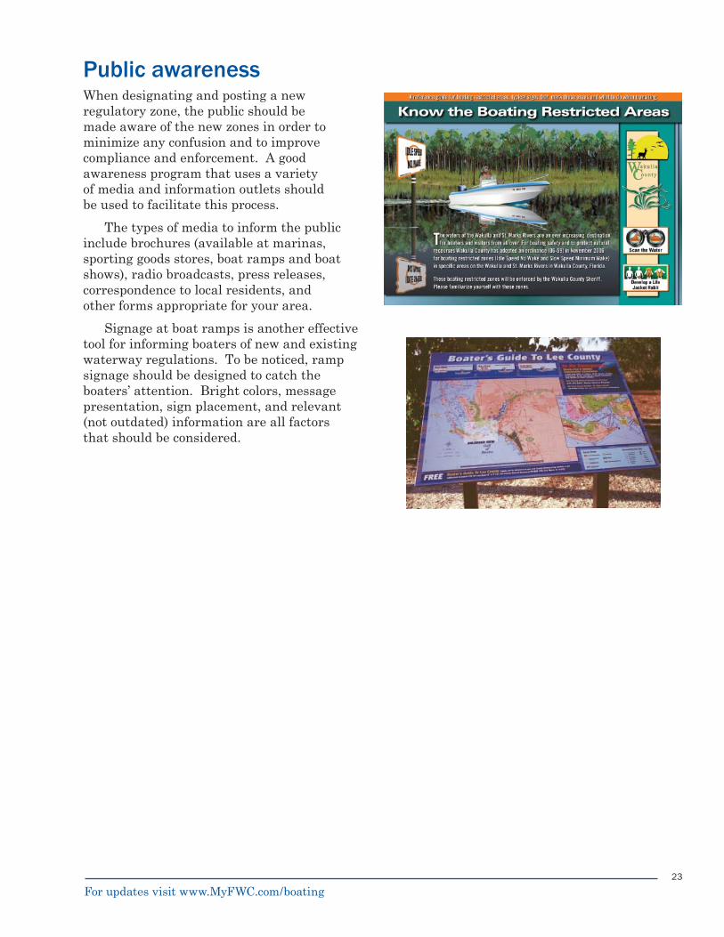
Public awarenessWhen designating and posting a new regulatory zone, the public should be made aware of the new zones in order to minimize any confusion and to improve compliance and enforcement. A good awareness program that uses a variety of media and information outlets should be used to facilitate this process.
The types of media to inform the public include brochures (available at marinas, sporting goods stores, boat ramps and boat shows), radio broadcasts, press releases, correspondence to local residents, and other forms appropriate for your area.
Signage at boat ramps is another effective tool for informing boaters of new and existing waterway regulations. To be noticed, ramp signage should be designed to catch the boaters’ attention. Bright colors, message presentation, sign placement, and relevant (not outdated) information are all factors that should be considered.
For updates visit www.MyFWC.com/boating
24
Maintenance, repair, and response
Marker maintenance All markers, once deployed, are exposed to extreme environments. Natural factors, including storms with their attendant winds, tidal surges, pounding rain, and other factors, signifi cantly degrade markers. Human factors, including vessel collisions, vessel wakes, and prop entangled buoy lines, also take their toll. Any waterway marker plan should include a marker maintenance schedule that includes routine inspections and repairs as needed. A maintenance program should also be able to provide immediate response when missing or damaged markers are reported from the public or from FWC’s On-Call Response Program. Pursuant to 68D-23.106(1)(d), FAC, the applicant must immediately report any discrepancy in the marker to the Boating and Waterways Section by telephone, telefacsimile, or other similarly rapid means of communication. Unless the applicant’s permit expressly provides for a longer period, the applicant must correct any discrepancy within not more than 30 days and must notify the Boating and Waterways Section when the correction is accomplished.
To minimize maintenance efforts, newly installed markers should conform to the highest construction standards. Poorly installed markers require extensive follow up maintenance, repairs, and replacement. Construction standards include appropriate marker designs (including piling platforms, sign face attachments and buoy mooring gear) and marker materials (types of pilings, hardware, sign faces, buoys, and anchors).
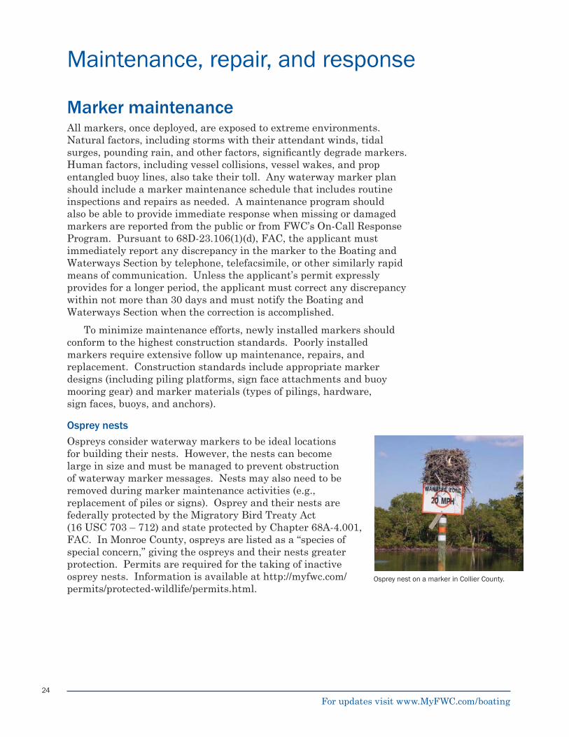
Osprey nestsOspreys consider waterway markers to be ideal locations for building their nests. However, the nests can become large in size and must be managed to prevent obstruction of waterway marker messages. Nests may also need to be removed during marker maintenance activities (e.g., replacement of piles or signs). Osprey and their nests are federally protected by the Migratory Bird Treaty Act (16 USC 703 – 712) and state protected by Chapter 68A-4.001, FAC. In Monroe County, ospreys are listed as a “species of special concern,” giving the ospreys and their nests greater protection. Permits are required for the taking of inactive osprey nests. Information is available at http://myfwc.com/permits/protected-wildlife/permits.html.
Osprey nest on a marker in Collier County.
For updates visit www.MyFWC.com/boating
25
Marker inventoryFWC has developed a Waterway Marker Inventory program to catalog existing waterway markers in state navigable waters as part of the FWC overall asset management system. The waterway marker inventory program will be used to assist personnel in the condition assessments of markers and performance of maintenance. This is particularly important following disaster events.
Initial inventory efforts include locating FWC owned or managed markers, assessing their condition, and entering marker information using a GPS unit compatible with a GIS program. The marker inventory database provides an effi cient and detailed mechanism for storing the location and assessed condition information, and provides a method of managing the assets by tracking the need for maintenance or replacement.
On-call and emergency response programsFWC has developed an On-Call program and an Emergency Response program. The On-Call program was designed to provide the public with a central location for reporting damage to markers and FWC assets (such as boat ramps), in addition to other navigational hazards and as a means by which to provide timely repairs.
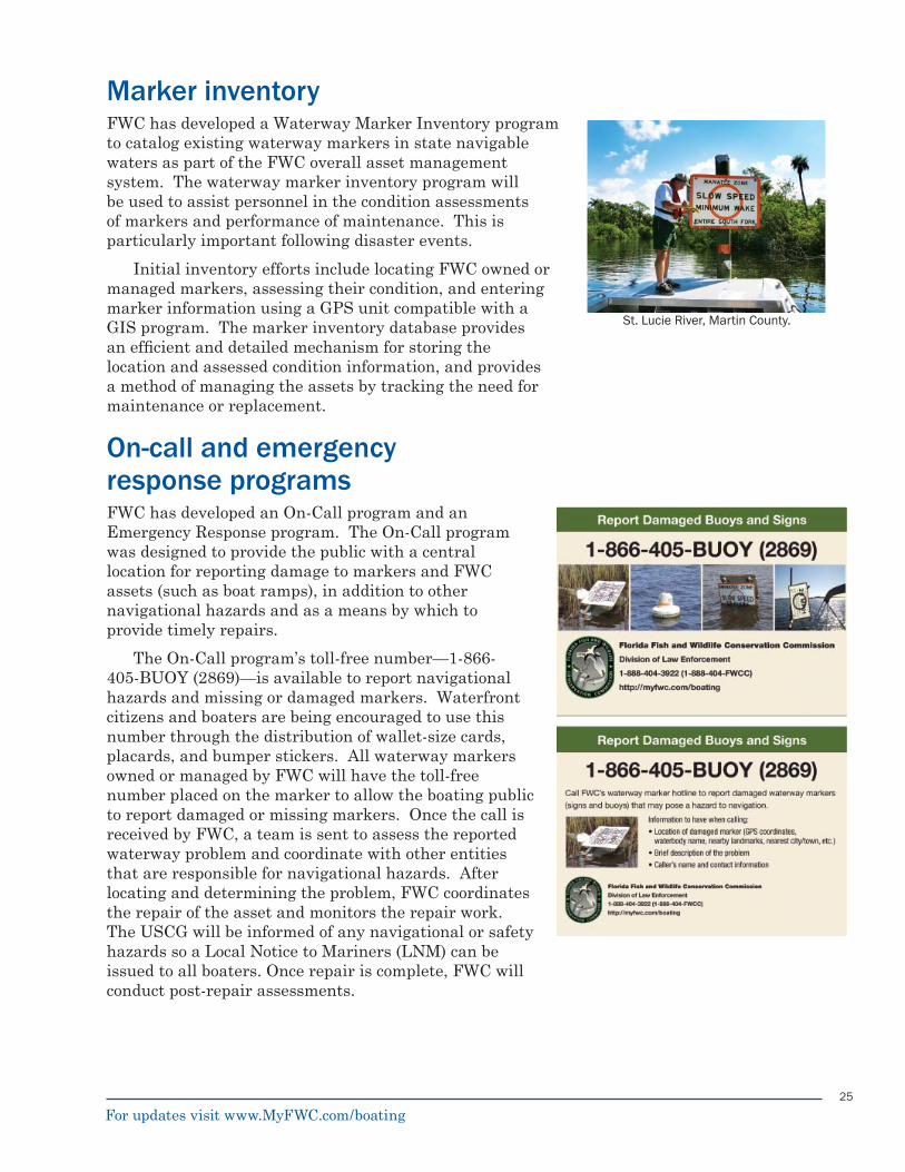
The On-Call program’s toll-free number—1-866-405-BUOY (2869)—is available to report navigational hazards and missing or damaged markers. Waterfront citizens and boaters are being encouraged to use this number through the distribution of wallet-size cards, placards, and bumper stickers. All waterway markers owned or managed by FWC will have the toll-free number placed on the marker to allow the boating public to report damaged or missing markers. Once the call is received by FWC, a team is sent to assess the reported waterway problem and coordinate with other entities that are responsible for navigational hazards. After locating and determining the problem, FWC coordinates the repair of the asset and monitors the repair work. The USCG will be informed of any navigational or safety hazards so a Local Notice to Mariners (LNM) can be issued to all boaters. Once repair is complete, FWC will conduct post-repair assessments.
St. Lucie River, Martin County.
For updates visit www.MyFWC.com/boating
26
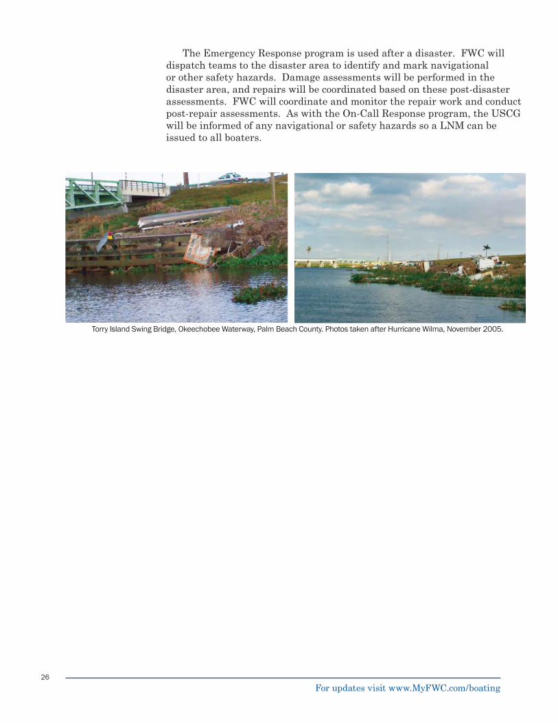
Torry Island Swing Bridge, Okeechobee Waterway, Palm Beach County. Photos taken after Hurricane Wilma, November 2005.
The Emergency Response program is used after a disaster. FWC will dispatch teams to the disaster area to identify and mark navigational or other safety hazards. Damage assessments will be performed in the disaster area, and repairs will be coordinated based on these post-disaster assessments. FWC will coordinate and monitor the repair work and conduct post-repair assessments. As with the On-Call Response program, the USCG will be informed of any navigational or safety hazards so a LNM can be issued to all boaters.
For updates visit www.MyFWC.com/boating
For updates visit www.MyFWC.com/boating
Appendices
A. Common regulatory sign messagesB. Buoy and sign design drawings and specifi cations C. Permit applicationD. Chapter 68C-22 Florida Administrative CodeE. Chapter 68D-23 Florida Administrative Code F. Code of Federal Regulations, Title 50, Chapter 1, Part 17-100G. USCG Aids to Navigation, Title 33 - Part 66

For updates visit www.MyFWC.com/boating
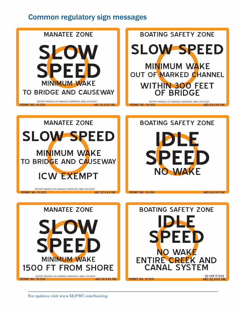
Regulatory sign examples
Appendix A
For updates visit www.MyFWC.com/boating
Common regulatory sign messages
PERMIT NO.: 91-000 68C-22.XXX FAC
MANATEE ZONE
SLOWSPEED
MINIMUM WAKETO BRIDGE AND CAUSEWAY
BOATING SAFETY ZONE
SLOW SPEEDMINIMUM WAKE
WITHIN 300 FEETOF BRIDGE
PERMIT NO.: 91-000 68D-24.XXX FAC
OUT OF MARKED CHANNEL
REPORT MISSING OR DAMAGED MARKERS: (866) 405-BUOY
MANATEE ZONE
SLOW SPEEDMINIMUM WAKE
ICW EXEMPT
PERMIT NO.: 91-000 68C-22.XXX FAC
TO BRIDGE AND CAUSEWAY
PERMIT NO.: 91-000 68D-24.XXX FAC
BOATING SAFETY ZONE
IDLESPEED
NO WAKE
MANATEE ZONE
SLOWSPEED
MINIMUM WAKE1500 FT FROM SHORE
PERMIT NO.: 91-000 68C-22.XXX FAC
BOATING SAFETY ZONE
IDLE
NO WAKEENTIRE CREEK AND
CANAL SYSTEM50 CFR 17.XXX
PERMIT NO.: 91-000 68C-22.XXX FAC
SPEED
REPORT MISSING OR DAMAGED MARKERS: (866) 405-BUOY
REPORT MISSING OR DAMAGED MARKERS: (866) 405-BUOY
REPORT MISSING OR DAMAGED MARKERS: (866) 405-BUOY
For updates visit www.MyFWC.com/boating
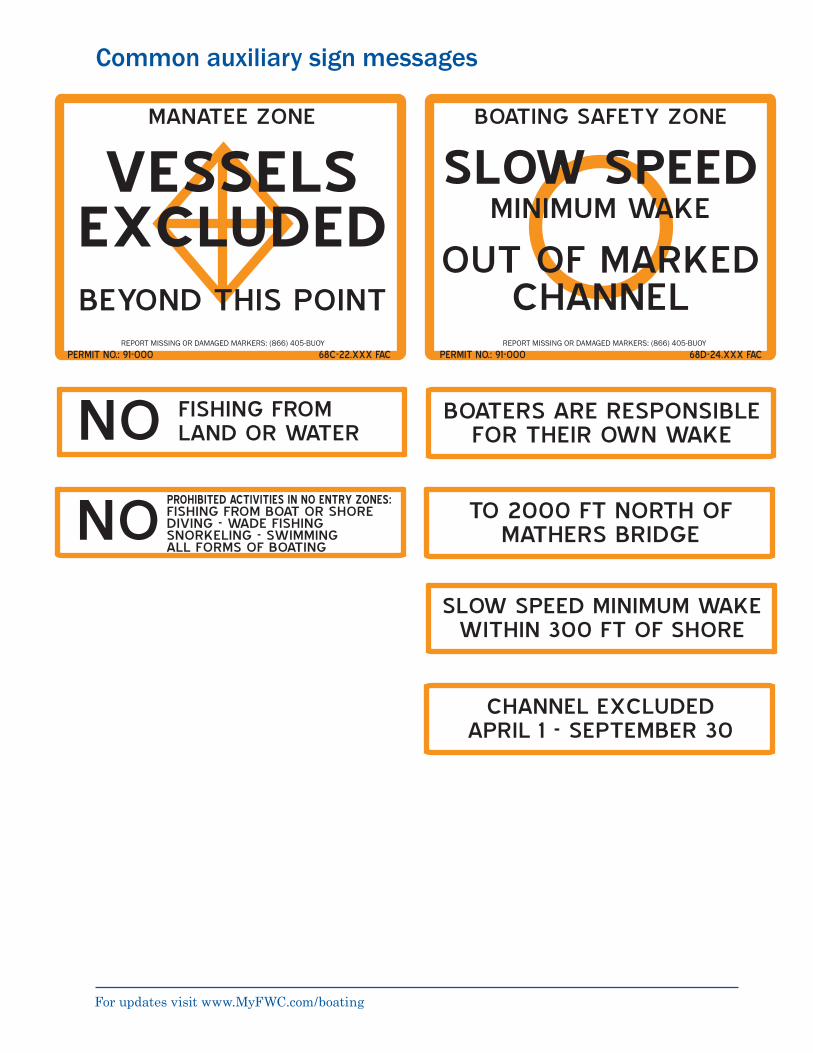
Common auxiliary sign messages
PERMIT NO.: 91-000 68C-22.XXX FAC
MANATEE ZONE
VESSELSEXCLUDEDBEYOND THIS POINT
BOATING SAFETY ZONE
SLOW SPEEDMINIMUM WAKE
PERMIT NO.: 91-000 68D-24.XXX FAC
OUT OF MARKED CHANNEL
BOATERS ARE RESPONSIBLE FOR THEIR OWN WAKE
FISHING FROM LAND OR WATERNO
TO 2000 FT NORTH OF MATHERS BRIDGENO
SLOW SPEED MINIMUM WAKE WITHIN 300 FT OF SHORE
CHANNEL EXCLUDEDAPRIL 1 - SEPTEMBER 30
PROHIBITED ACTIVITIES IN NO ENTRY ZONES:FISHING FROM BOAT OR SHOREDIVING - WADE FISHINGSNORKELING - SWIMMINGALL FORMS OF BOATING
REPORT MISSING OR DAMAGED MARKERS: (866) 405-BUOY REPORT MISSING OR DAMAGED MARKERS: (866) 405-BUOY
For updates visit www.MyFWC.com/boating
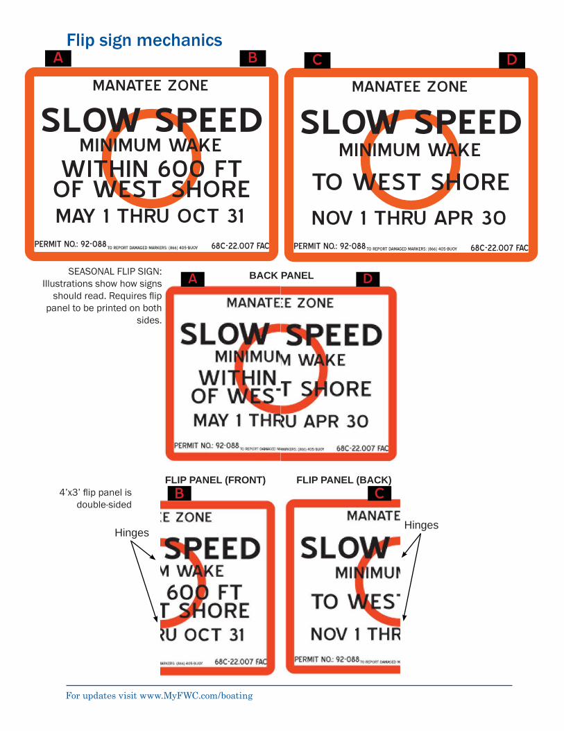
Flip sign mechanics
SEASONAL FLIP SIGN: Illustrations show how signs
should read. Requires fl ip panel to be printed on both
sides.
4’x3’ fl ip panel is double-sided
BACK PANEL
TO REPORT DAMAGED MARKERS: (866) 405-BUOY
MANATEE ZONE
TO REPORT DAMAGED MARKERS: (866) 405-BUOY
MANATEE ZONE
PERMIT NO.: 92-088 68C-22.007 FAC
SLOW SPEEDMINIMUM WAKE
MAY 1 THRU OCT 31
WITHIN 600 FTOF WEST SHORE
PERMIT NO.: 92-088 68C-22.007 FAC
SLOW SPEEDMINIMUM WAKE
NOV 1 THRU APR 30
TO WEST SHORE
A B DC
A D
FLIP PANEL (FRONT) FLIP PANEL (BACK)
HingesHinges
B C

For updates visit www.MyFWC.com/boating
Buoy and sign design drawings and specifi cations
Appendix B

02481 – 1: Revised 02/28/2008
TECHNICAL SPECIFICATIONS FOR THE
INSTALLATION, REPAIR, AND REMOVAL OF UNIFORM WATERWAY MARKERS AND RELATED SERVICES
SECTION 02481 – LOCATION
PART 1 – GENERAL
1.01 DESCRIPTION The following technical specifications cover the work locations of all types of waterway markers that could be involved in this contract. Work under this contract will be limited to the specific markers shown on the attached plans or contract addenda or change orders.
1.02 REFERENCES The CONTRACTOR shall complete all construction in accordance with the waterway marker plans and specifications provided.
1.03 DELIVERY, STORAGE, AND HANDLING (Not Used) 1.04 WARRANTIES (Not Used) 1.05 RELATED WORK
The OWNER/ENGINEER may require additional installation projects, needed repairs, and/or disposals during the contract period. Any additional work shall be completed at the unit prices established in the schedule of values or as otherwise mutually agreed to in writing. Only additional installations, repairs, and/or disposals requested by the OWNER/ENGINEER will be authorized for payment.
1.06 MODIFICATIONS
Any modifications or deviations from the original work plan, written, or detailed technical specifications must be pre-approved prior to construction by the OWNER/ENGINEER. PART 2 – PRODUCTS (Not Used) PART 3 – EXECUTION 3.01 INSTALLATION / APPLICATION / ERECTION
For the installation of waterway markers, the CONTRACTOR will locate sign and/or buoy positions using a WAAS enabled digital global positioning system (DGPS) with WGS-84 map datum. Installed positions shall be within two (2) meters (6 feet) of the location designated by OWNER/ENGINEER on the maps or waterway marker plan. Sign and/or buoy positions are not to be installed within the ICW nor in any location so as to obstruct navigation of the ICW. Discrepancies between the coordinates of the sign location provided on the work order list and/or the graphic representation shown on the maps shall be reported to OWNER/ENGINEER prior to installation. The CONTRACTOR is to determine if underground or overhead utilities exist at all work locations and propose adjustments to work locations as needed to avoid any damage to
SECTION 02481 - LOCATION TECHNICAL SPECIFICATIONS INSTALLATION, REPAIR, AND REMOVAL OF UNIFORM WATERWAY MARKERS AND RELATED SERVICES
02481 – 2: Revised 02/28/2008
existing utilities. CONTRACTOR must contact Sunshine Utilities (1-800-432-4770) prior to the commencement of construction.
The CONTRACTOR is to verify water depths and bottom types at all work locations. Depth information on the attached plans (if provided) is approximate and does not reflect tidal fluctuations.
3.02 MAINTENANCE Locations of required maintenance, repair, and replacement of waterway marker elements are provided in the attached waterway marker plans. The CONTRACTOR shall inspect each location prior to commencement of work to verify the condition of each element and to determine the equipment, supplies and effort required. The CONTRACTOR shall provide and install all components necessary for repair or replacement of existing markers, other than sign panels and buoys furnished by the OWNER/ENGINEER. Necessary components shall meet the minimum requirements for new installations. Any discrepancies noted during verification inspection shall be brought to the attention of the OWNER/ENGINEER immediately.
3.03 RECORDS The CONTRACTOR shall maintain records for each sign installation and maintenance site worked under this contract. For each sign site, these records shall include the type of work performed including the number of piles installed, the date of installation, the size and length of the piles, the depth of penetration of each pile, and other work.
The CONTRACTOR must provide the OWNER/ENGINEER with the coordinates in degrees and decimal minutes (example N30°07.980’, W81°27.675’) for all regulatory markers installed, repaired or maintained. These positions must be accurate to two (2) meters (6 feet) resolution using DGPS, WAAS enabled with WGS-84 map datum. The CONTRACTOR shall provide digital photographs of each marker and marker installation. The photographs must be clear, legible, and identified with the waterway marker plan’s reference number.

02482 – 1: Revised 02/28/2008
TECHNICAL SPECIFICATIONS
FOR THE INSTALLATION, REPAIR, AND REMOVAL OF UNIFORM WATERWAY MARKERS AND
RELATED SERVICES
02482 – PILE & SIGN
PART 1 – GENERAL
1.01 DESCRIPTION The following technical specifications cover the installation, repair, and removal of piles and signs involved in this contract. Work under this contract will be limited to the specific markers shown on the attached plans or contract addenda or change orders.
1.02 REFERENCES The CONTRACTOR shall complete all construction in accordance with the waterway marker plans and specifications provided.
1.03 DELIVERY, STORAGE, AND HANDLING CONTRACTOR shall contact the OWNER/ENGINEER to coordinate shipping and delivery of signs from the manufacturer. CONTRACTOR will be responsible for signs upon receipt. The CONTRACTOR is responsible for all delivery, storage, and handling of pilings used.
1.04 WARRANTIES All materials utilized shall be able to withstand the elements under outdoor marine conditions for a continuous period of not less than five (5) years.
1.05 RELATED WORK The OWNER/ENGINEER may require additional installation projects, needed repairs, and/or disposals during the contract period. Any additional work shall be completed at the unit prices established in the schedule of values or as otherwise mutually agreed to in writing. Only additional installations, repairs, and/or disposals requested in writing by the OWNER/ENGINEER will be authorized for payment.
1.06 MODIFICATIONS
Any modifications or deviations from the original work plan, written, or detailed technical specifications must be pre-approved prior to construction by the OWNER/ENGINEER. PART 2 – PRODUCTS 2.01 MATERIAL
Aluminum waterway marker sign panels will be supplied by the OWNER/ENGINEER and installed by the CONTRACTOR. All materials and hardware needed for construction and installation (including treated timber piles) will be supplied by the CONTRACTOR. OWNER/ENGINEER may provide specialized hardware at their discretion.
02482 – 2: Revised 02/28/2008
PART 3 – EXECUTION 3.01 INSTALLATION / APPLICATION / ERECTION
All signs shall conform to the Florida Uniform Waterway Marking System in accordance with Florida Statutes 327.40(1).
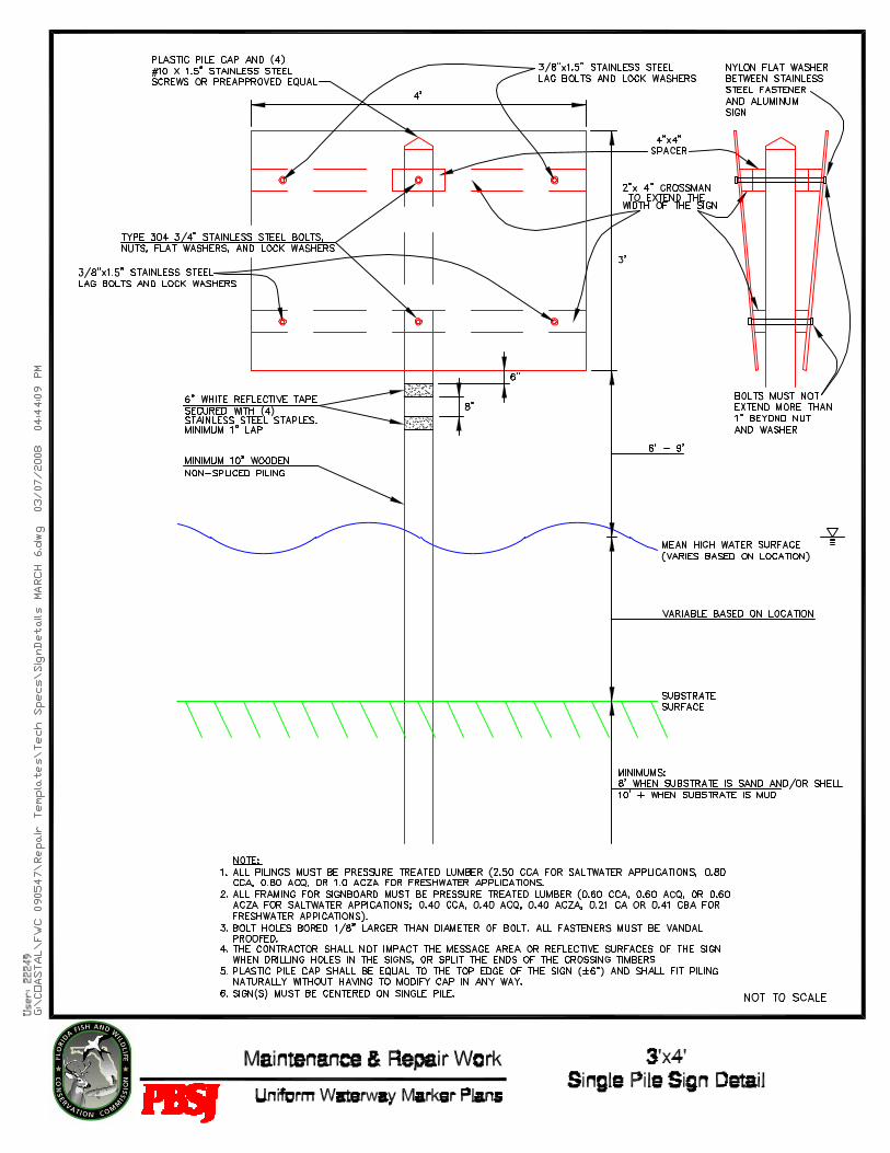
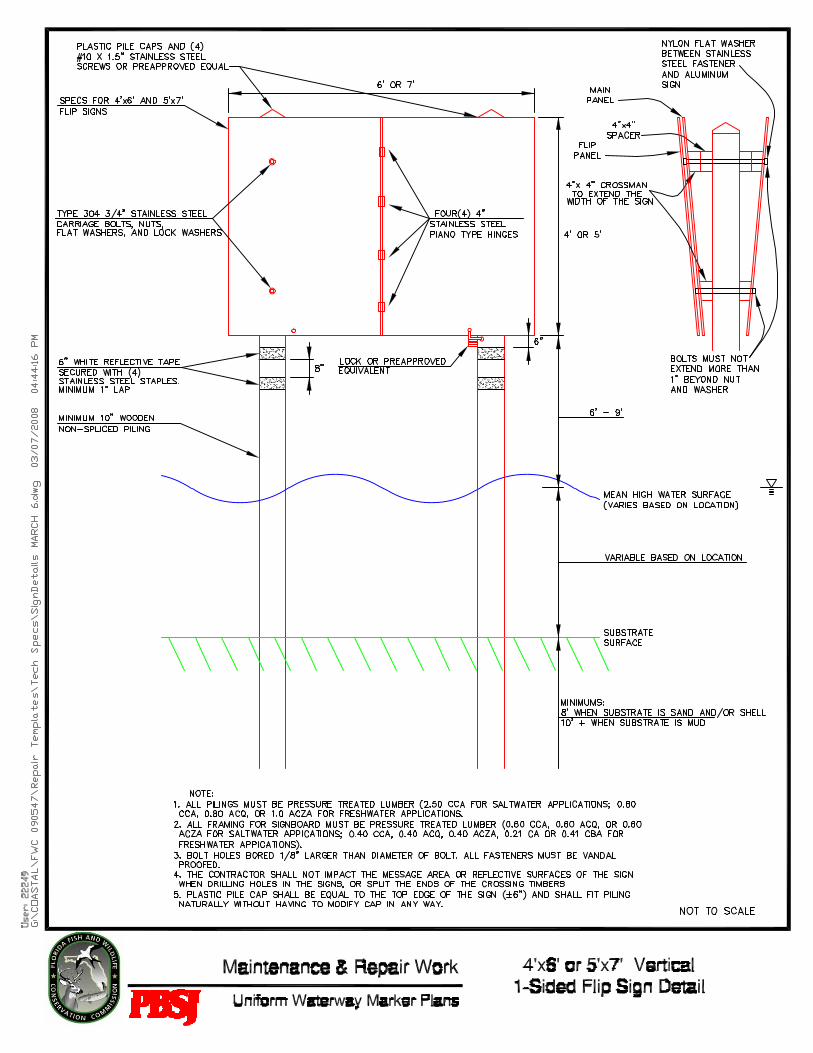
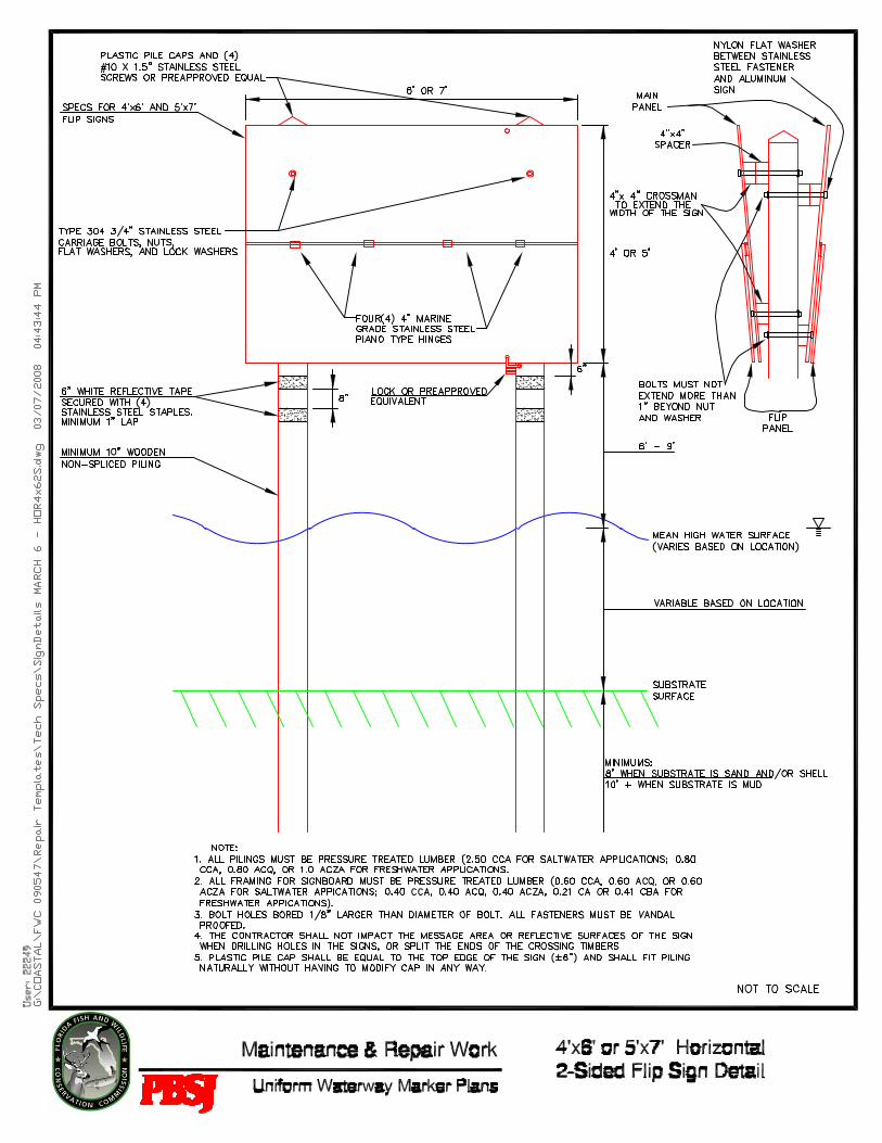
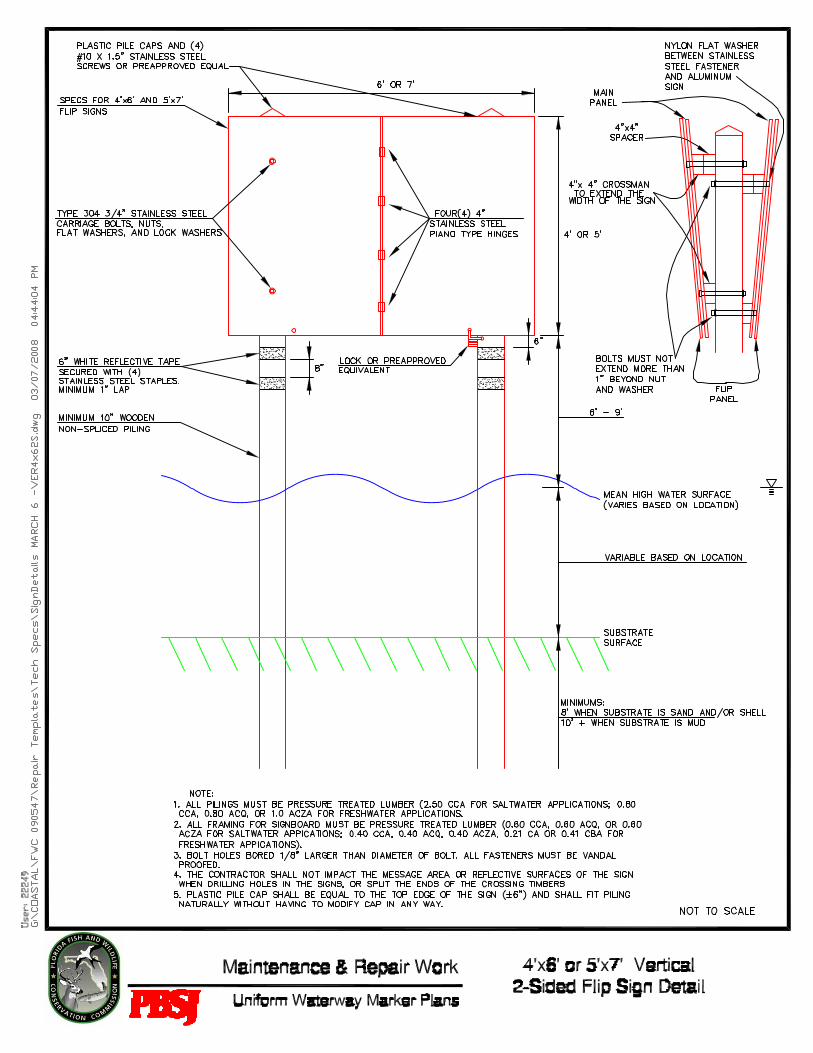
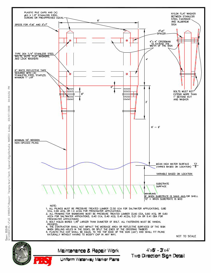
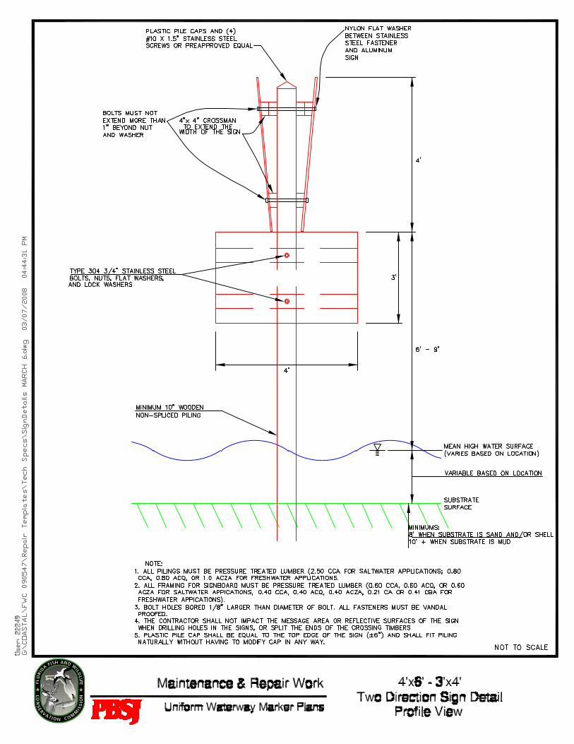
3.01.1 PILE INSTALLATION Standard treated timber pilings shall be at least 10” in diameter unless otherwise indicated in the waterway marker plan. For salt or brackish water applications, the timber pilings shall be pressure treated with Chromated Copper Arsenate (2.50), and for freshwater applications, the timber pilings shall be pressure treated with Chromated Copper Arsenate (0.80), Alkaline copper quat. (0.80), or Ammoniacal copper zinc arsenate (1.0). Piles shall be carefully handled with no sudden dropping, breaking of outer fibers, bruising, or penetration of the surface with tools. Bolt holes shall be bored 1/8” larger than the diameter of the bolt. Any piles which require excessive bending in order to frame properly shall be withdrawn and reinstalled to the proper batter. Piles shall not be installed and then pulled into position. Minor adjustment (less than 3° to vertical) is allowed after pile installation; however, CONTRACTOR is fully responsible to ensure soil has settled around the pile so that no listing will occur. Piles damaged, not located in the proper location, or driven out of alignment shall be withdrawn and replaced by new piles or shall be cut off at the mud-line and additional piles installed as directed, all without additional cost to the OWNER/ENGINEER. When installing more than one piling per marker installation, the pile tops shall be cut to equal height (± 1”). All piles shall be capped with plastic pointed black caps attached with a minimum of (4) #10 x 1.5” stainless steel screws (or preapproved by OWNER/ENGINEER equivalent) and be even with the top edge of the sign to (± 6”). The cap shall fit the piling naturally without having to modify the pile cap in any fashion to forcefully fit the pile diameter (e.g. splitting a cap to fit a larger diameter piling than the pile cap was designed to fit). For salt or brackish water applications, the crossmen shall be treated with Chromated Copper Arsenate (0.60), Alkaline copper quat. (0.60), or Ammoniacal copper zinc arsenate (0.60), and for freshwater applications, the crossmen shall be treated with Chromated Copper Arsenate (0.40), Alkaline copper quat. (0.40), Ammoniacal copper zinc arsenate (0.40), Copper Azole (0.21), or Copper boron azole (0.41) and attached as shown on the waterway marker plans. Most sign installations will be front and back.
Signs must be installed as indicated on the waterway marker plans with pilings to be shortened as dictated by the normal mean high watermark in the area of installation. The bottom of all signage must be a minimum of 6 feet above the mean high water level and not exceed 9 feet above the mean high water level. Pilings shall penetrate at least 8 feet of sand and/or shell, or at least 10 feet or more of mud, as appropriate to support the marker. If rock is encountered, pre-drilling of the pile hole and /or a pile shoe may be required at no additional cost to the OWNER/ENGINEER. If an augering or punching method is deemed necessary to install piling into rock or hard substrate, the method must first be approved by the OWNER/ENGINEER. If these methods require grouting, the materials and methodology must also be approved by the OWNER/ENGINEER. Pilings shall not be connected, or joined together to lengthen.
SECTION 02482 - PILE & SIGN TECHNICAL SPECIFICATIONS INSTALLATION, REPAIR, AND REMOVAL OF UNIFORM WATERWAY MARKERS AND RELATED SERVICES
02482 – 3: Revised 02/28/2008
Sign or pile assemblies not completed at the end of each work day must be marked and made visible to day and nighttime waterway traffic. However, no more than two (2) pile assemblies (single or double) may be left unfinished at the end of each work day. For pile installation, the CONTRACTOR will supply Reflective Tape Bands in accordance with Section 3.01.7.
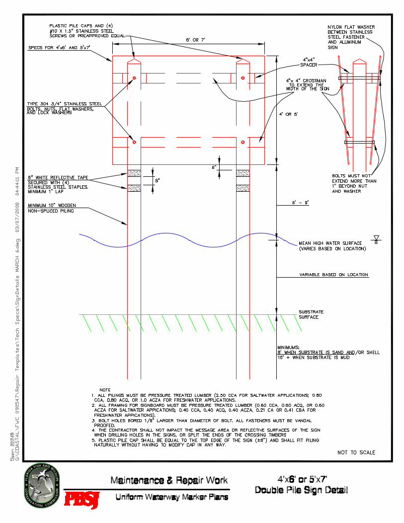
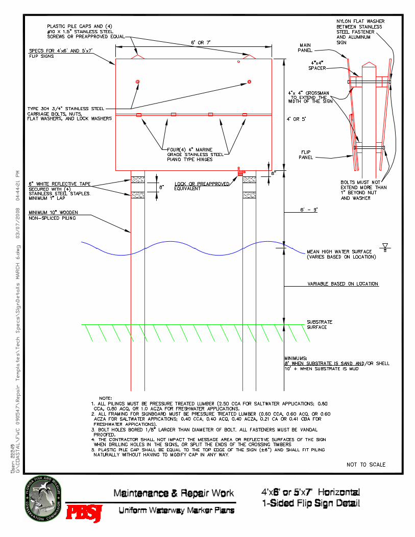
3.01.2 SIGN INSTALLATION – DOUBLE PILE 4’x6’ AND 5’x7’ All installations of 4’ x 6’ and 5’ x 7’ signs shall be mounted on two 10” diameter (or larger) standard treated timber pilings. Signs shall be drilled and fastened by penetration of each post by two (2) type 304 ¾” stainless steel through bolts, which must not extend more than 1” or less than ½” beyond type 304 stainless steel hex-nut, stainless steel lock washers, and stainless steel flat washers. A nylon flat washer will be placed between stainless steel fasteners and aluminum signs to prevent bi-metallic corrosion. All fasteners shall be vandal proofed.
Timber 4” x 4” crossmen shall be installed at the top and bottom on the back of all signs and 4” x 4” timber spacers at the top of the sign, so that the sign will be slanted out, all in accordance with the waterway marker plan details. For sign installations that are double faced (front and back), the through bolt must extend from front to back sign, through crossmen and pilings.
Sign shall be drilled and fastened to crossmen with 3/8” x 1.5” stainless steel lag bolts, stainless steel lock washers, and stainless steel flat washers adjacent to the four corners of the sign, as shown on the double pile sign detail. A nylon flat washer will be placed between stainless steel fasteners and aluminum signs to prevent bi-metallic corrosion. All fasteners shall be vandal proofed.
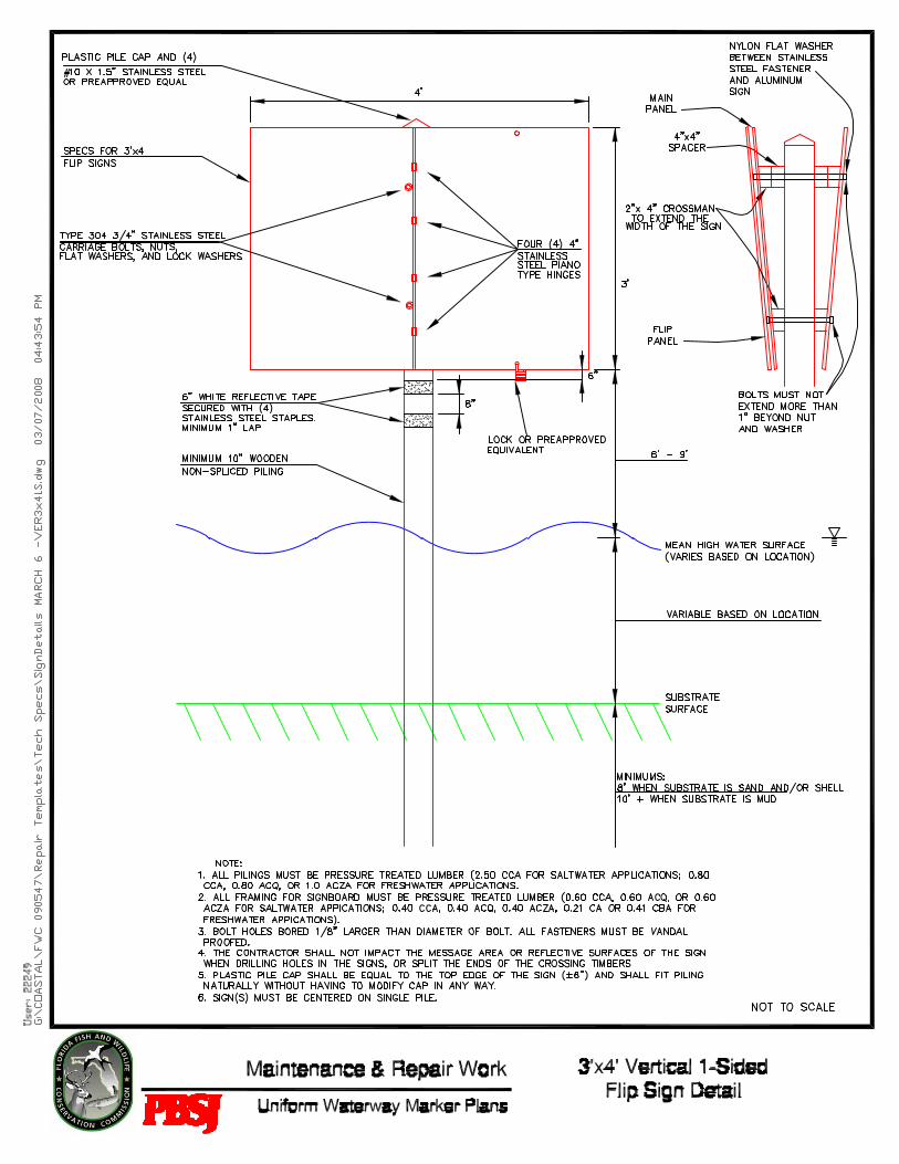
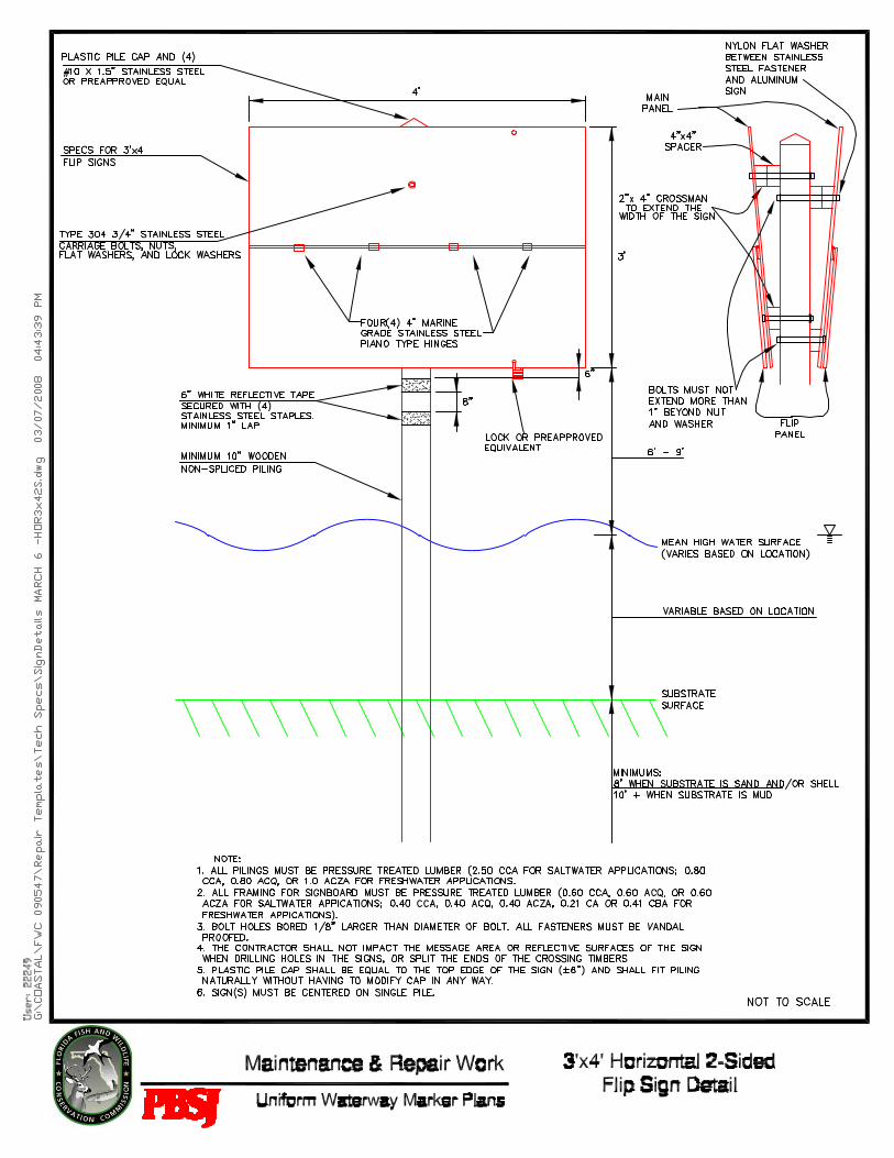
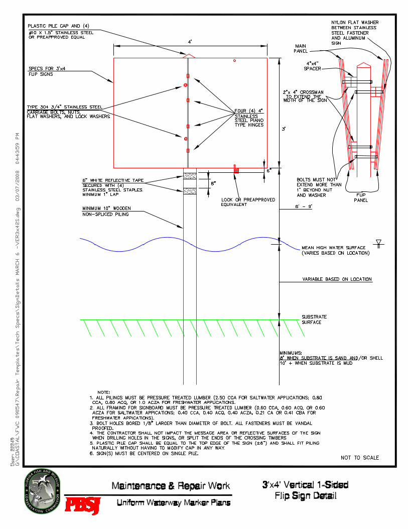
3.01.3 SIGN INSTALLATION – SINGLE PILE 3’x4’ All installations of 3’ x 4’ signs shall be mounted on one 10” diameter (or larger) standard treated timber piling. Signs shall be drilled and fastened by penetration of the post by two (2) type 304 stainless steel ¾” through bolts, which must not extend more than 1” or less than ½” beyond type 304 stainless steel hex-nut, stainless steel lock washer, and stainless steel flat washer. A nylon flat washer will be placed between stainless steel fasteners and aluminum signs to prevent bi-metallic corrosion. All fasteners shall be vandal proofed.
Timber 2” x 4” crossmen shall be installed at the top and bottom on the back of all signs and 4” x 4” timber spacers at the top of the sign so that the sign will be slanted out, all in accordance with the plan details. For sign installations that are double faced (front and back), the through bolt must extend from front to back sign, through crossmen and piling.
Sign shall be drilled and fastened to crossmen with 3/8” x 1.5” stainless steel lag bolts, stainless steel lock washers, and stainless steel flat washers adjacent to the four corners of the sign, as shown on the single pile sign detail. A nylon flat washer will be placed between stainless steel fasteners and aluminum signs to prevent bi-metallic corrosion. All fasteners shall be vandal proofed.
3.01.4 SIGN INSTALLATION – VERTICAL AND HORIZONTAL FLIP SIGNS All installations of 3’ x 4’ vertical and horizontal flip signs shall be mounted on one 10” diameter (or larger) standard treated timber piling. Sign(s) must be centered on single piles. All installations of 4’ x 6’ and 5’ x 7’ vertical and horizontal flip signs shall be mounted on two 10” diameter (or larger) standard
SECTION 02482 - PILE & SIGN TECHNICAL SPECIFICATIONS INSTALLATION, REPAIR, AND REMOVAL OF UNIFORM WATERWAY MARKERS AND RELATED SERVICES
02482 – 4: Revised 02/28/2008
treated timber pilings. Main sign panels shall be drilled and fastened by penetration of each post by type 304 ¾” stainless steel carriage bolts, which must not extend more than 1” beyond type 304 stainless steel hex-nut, stainless steel lock washers, and stainless steel flat washers. A nylon flat washer will be placed between stainless steel fasteners and aluminum signs to prevent bi-metallic corrosion. All fasteners shall be vandal proofed. When both sides of a double-sided marker are flip signs, the crossmen shall be offset.
Timber 4” x 4” crossmen shall be installed at the top and bottom on the back of all main sign panels and 4” x 4” timber spacers at the top of the sign, so that the sign will be slanted out, all in accordance with the waterway marker plan details. For sign installations that are double faced (front and back), the through bolt must extend from front to back of main sign panel, through crossmen and pilings.
Sign shall be drilled and fastened to crossmen with 3/8” x 1.5” stainless steel lag bolts, stainless steel lock washers, and stainless steel flat washers adjacent to the four corners of the sign, as shown on the horizontal flip sign detail. A nylon flat washer will be placed between stainless steel fasteners and aluminum signs to isolate dissimilar metals from each other. All fasteners shall be vandal proofed.
A vertical flip sign includes a full sized main panel and a flip panel of half the width of the full sized main panel. The inner side edge of the flip panel is attached to the middle of the main panel by the sign manufacturer using stainless steel piano-type hinges, attached using bolts to the hinge manufacturer’s specifications.
A 3’ x 4’ vertical flip sign consists of a 3’ x 4’ main panel and a 3’ x 2’ flip panel; a 4’ x 6’ vertical flip sign consists of a 4’ x 6’ main panel and a 4’ x 3’ flip panel; and a 5’ x 7’ vertical flip sign consists of a 5’ x 7’ main panel and a 5’ x 3-1/2’ flip panel. Flip panels shall be attached to the main sign panel using stainless steel hinges. A 3’ x 4’ vertical flip sign will have two (2) 4” stainless steel piano type hinges and 4’ x 6’ and 5’ x 7’ vertical flip signs will have four (4) 4” stainless steel piano type hinges. Each flip panel shall have a hole drilled into the lower outer corner of the flip panel and must be aligned with a hole drilled into the bottom right and left corners of the main panel. The existing lock (if present) shall be used to secure the main and flip panels together. The CONTRACTOR shall coordinate the repair and/or maintenance of markers with existing locks with OWNER/ENGINEER to obtain any key or combinations necessary to unlock existing locks. If no lock is present (i.e. missing or a new flip sign installation) locks or preapproved equivalent (e.g. bolts) appropriate for use in a marine environment will be provided by CONTRACTOR. Each side of the flip panel will be constructed of the same gauge aluminum as the main panel, and be similar in style with regards to reflective sheeting, black block lettering, border, and geometric symbol.
A horizontal flip sign includes a full sized main panel and a flip panel of half the height of the full sized main panel. The top edge of the flip panel is attached to the middle of the main panel by the sign manufacturer, using stainless steel piano-type hinges, attached using bolts to the hinge manufacturer’s specifications.
A 3’ x 4’ horizontal flip sign consists of a 3’ x 4’ main panel and a 1-1/2’ x 4’ flip panel; a 4’ x 6’ vertical flip sign consists of a 4’ x 6’ main panel and a 2’ x 6’ flip panel; and a 5’ x 7’ vertical flip sign consists of a 5’ x 7’ main panel and a 2-1/2’ x
SECTION 02482 - PILE & SIGN TECHNICAL SPECIFICATIONS INSTALLATION, REPAIR, AND REMOVAL OF UNIFORM WATERWAY MARKERS AND RELATED SERVICES
02482 – 5: Revised 02/28/2008
7’ flip panel. Flip panels shall be attached to the main sign panel using stainless steel hinges. A 3’ x 4’ horizontal flip sign will have two (2) 4” stainless steel piano type hinges and 4’ x 6’ and 5’ x 7’ horizontal flip signs will have four (4) 4” stainless steel piano type hinges. Each flip panel shall have a hole drilled into the lower middle of the flip panel and must be aligned with holes drilled into the top and bottom middle of the main panel. The existing lock (if present) shall be used to secure the main and flip panels together. The CONTRACTOR shall coordinate the repair and/or maintenance of markers with existing locks with OWNER/ENGINEER to obtain any key or combinations necessary to unlock existing locks. If no lock is present (i.e. missing or a new flip sign installation) locks or preapproved equivalent (e.g. bolts) appropriate for use in a marine environment will be provided by CONTRACTOR. Each side of the flip panel will be constructed of the same gauge aluminum as the main panel, and be similar in style with regards to reflective sheeting, black block lettering, border, and geometric symbol.
3.01.5 PROTECTION OF THE SIGNS Signs will not have predrilled holes. The CONTRACTOR shall not impact the message area or reflective surfaces of the sign when drilling holes in the signs, or split the ends of the 2” x 4” or 4” x 4” crossmen timbers on the backs of signs. The CONTRACTOR will replace, at its own expense, any signs that it damages during the delivery and installation process.
3.01.6 SIGN SPECIFICATIONS AND LETTERING Waterway marker signs have been or will be purchased and furnished by the Florida Fish & Wildlife Conservation Commission (FWC) or the OWNER/ENGINEER and delivered directly to the CONTRACTOR. The OWNER/ENGINEER will provide the CONTRACTOR with sign graphics and a list to ensure accuracy in sign sizes and numbers of each sign ordered. The CONTRACTOR will verify that signs have been delivered in good condition and contain the following lettering:
Black block 1” lettering stating the permit number shall appear on the lower left and the rule/ordinance number shall appear on the lower right. If needed, the verbiage “Manatee Zone” or “Boating Safety Zone” shall be black block 3” lettering. Regulatory lettering (example: Slow Speed Minimum Wake, Idle Speed No Wake, and Resume Normal Safe Operation) shall be black block lettering and centered within sign panel. Unless specifically requested, the verbiage “Manatee Zone” or “Boating Safety Zone” shall not appear on signs stating “Resume Normal Safe Operation”.
3.01.7 REFLECTIVE TAPE BANDS The CONTRACTOR shall supply two 6” single-bands of 3M High Intensity (#3870) White Reflective Tape that are to be placed around each piling, with a minimum of a 1” lap (the entire 6” width of the tape) with the first band being placed 6” from the bottom of the sign, and the second band being placed 8” from the bottom of the first band. If the tape becomes delaminated, cracked, checked, weathered, or abraded so as to have a brittle or roughened surface within the warranty period, it must be replaced.
If any tape is to be applied to existing piles, the old tape shall be completely removed and appropriately disposed of before applying the replacement
SECTION 02482 - PILE & SIGN TECHNICAL SPECIFICATIONS INSTALLATION, REPAIR, AND REMOVAL OF UNIFORM WATERWAY MARKERS AND RELATED SERVICES
02482 – 6: Revised 02/28/2008
reflective tape. In addition, all tape shall be adequately secured with a minimum of 4 stainless steel staples or otherwise in accordance with the manufacturer’s recommendations.
3.02 MAINTENANCE Descriptions of required maintenance, repair, and replacement of waterway marker elements are provided in the attached waterway marker plans. The CONTRACTOR shall inspect each location prior to commencement of work to verify the condition of each element and to determine the equipment, supplies, and effort required. The CONTRACTOR shall provide and install all components necessary for repair or replacement of existing markers, other than sign panels furnished by the OWNER/ENGINEER. Necessary components shall meet the minimum requirements for new installations. Any discrepancies noted during verification inspection shall be brought to the attention of the OWNER/ENGINEER immediately.
3.02.1 CLEANING OF SIGNS Signs that are soiled with fecal matter, marine residue, mold, mud, or other matter will be cleaned to bring them back into compliance with uniform waterway marker standards. The CONTRACTOR shall use methods that will not damage existing reflective sign panels, tape, fasteners, piles, or other sign elements. Any chemicals, soaps, or other materials must be free of phosphates, ammonia, sodium hypochlorite, chlorinated solvents, petroleum distillates, or lye. Cleaners must also be biodegradable and must be safe for the marine environment in accordance with Florida Department of Environmental Protection Rules and Regulations.
The CONTRACTOR shall submit all Material Safety Data Sheets (MSDS) to the OWNER/ENGINEER for approval prior to use of any chemicals or soaps. If pressure washing systems are used, the CONTRACTOR shall protect reflective coverings, tape or other elements that could be damaged or become dislodged during cleaning. The CONTRACTOR should avoid the use of abrasive cleaners that could damage the finish of sign panels. Any damage caused by cleaning methods employed by the CONTRACTOR shall be repaired at no cost to the OWNER/ENGINEER.
3.02.2 DAMAGED OR DISPLACED PILES Piles that are cracked, split, or otherwise damaged beyond repair must be removed and replaced with new piles of the same material, dimensions, and locations in accordance with these specifications.
Piles that have moved from vertical position and are not damaged must be straightened to an upright position. A pile that remains loose after straightening may indicate that the piling located beneath the water surface has been damaged or decayed, and will require removal. Any damage observed on a pile that was to be straightened to an upright position shall be reported to the OWNER/ENGINEER. The OWNER/ENGINEER’s representative will make the final determination regarding replacement of the pile.
Piles shall be removed in accordance with item 3.02.3 below and shall be re-installed in accordance with item 3.01 of this technical specification.
SECTION 02482 - PILE & SIGN TECHNICAL SPECIFICATIONS INSTALLATION, REPAIR, AND REMOVAL OF UNIFORM WATERWAY MARKERS AND RELATED SERVICES
02482 – 7: Revised 02/28/2008
3.02.3 PILING / SIGN REMOVAL AND DISPOSAL Steel, timber, or concrete piles shall be removed by the CONTRACTOR at the locations indicated on the attached waterway marker plans. Timber pilings are typically 10” diameter and are assumed to have been jetted into the bottom. The CONTRACTOR shall make every effort to remove each piling in its entirety by pulling or using a jet pump. Should the CONTRACTOR be unable to remove the piling, it may be cut, but the cut must occur at or below the mud line. If removal by cutting is required, the CONTRACTOR shall record the location and provide certification that the piling was cut at or below the mud line.
All items removed must be properly disposed of in compliance with all federal, state, and local laws and ordinances.
3.03 RECORDS The CONTRACTOR shall maintain records for each marker installation and maintenance site worked under this contract. For each marker site, these records shall include the type of work performed including the number of piles installed, the date of installation, the size and length of the piles, the depth of penetration of each pile, and other work.
The CONTRACTOR must provide the OWNER/ENGINEER with the coordinates in degrees and decimal minutes (example: N30° 07.980’, W81° 27.675’) for all markers installed, repaired or maintained. These positions must be accurate to two (2) meters (6 feet) resolution using DGPS, WAAS enabled with WGS-84 map datum. The CONTRACTOR shall provide digital photographs of each marker and marker installation. The photographs must be clear, legible, and identified with the waterway marker plan’s reference number.

02483 – 1: Revised 02/28/2008
TECHNICAL SPECIFICATIONS FOR THE
INSTALLATION, REPAIR, AND REMOVAL OF UNIFORM WATERWAY MARKERS AND RELATED SERVICES
02483 – BUOYS
PART 1 – GENERAL
1.01 DESCRIPTION The following technical specifications cover the installation, repair, and removal of buoys. Work under this contract will be limited to the specific markers shown on the attached plans or contract addenda or change orders.
1.02 REFERENCES The CONTRACTOR shall complete all construction in accordance with the waterway marker plans and specifications provided.
1.03 DELIVERY, STORAGE, AND HANDLING CONTRACTOR shall contact the OWNER/ENGINEER to coordinate shipping and delivery of buoys from the manufacturer. CONTRACTOR will be responsible for buoys upon receipt.
1.04 WARRANTIES All materials utilized shall be able to withstand the elements under outdoor marine conditions for a continuous period of not less than five (5) years.
1.05 RELATED WORK The OWNER/ENGINEER may require additional installation projects, needed repairs, and/or disposals during the contract period. Any additional work shall be completed at the unit prices established in the schedule of values or as otherwise mutually agreed to in writing. Only additional installations, repairs, and/or disposals requested in writing by the OWNER/ENGINEER will be authorized for payment.
1.06 MODIFICATIONS
Any modifications or deviations from the original work plan, written, or detailed technical specifications must be pre-approved prior to construction by the OWNER/ENGINEER. PART 2 – PRODUCTS 2.01 MATERIAL
Buoys will be supplied by the OWNER/ENGINEER and installed by the CONTRACTOR. All other materials and hardware needed for construction and installation (including buoy hardware and anchors) will be supplied by the CONTRACTOR.
02483 – 2: Revised 02/28/2008
PART 3 – EXECUTION 3.01 INSTALLATION / APPLICATION / ERECTION
All buoys shall conform to the Florida Uniform Waterway Marking System in accordance with Florida Statutes 327.40(1). CONTRACTOR must provide proof to the OWNER/ENGINEER that the company used to provide any buoy or anchor service has their commercial diving certifications that meet OSHA and United States Coast Guard requirements.
3.01.1 MOORING SYSTEMS Galvanized and stainless steel parts cannot be interchanged.
3.01.1.1 TRADITIONAL BUOY MOORING SYSTEM A minimum of two (2) clamps will be used at each anchor point. Total cable length shall be left to CONTRACTOR’s discretion to ensure that tidal fluctuations do not fatigue the cable. The CONTRACTOR shall utilize all necessary stainless steel hardware for saltwater or freshwater installation (shackle, thimble, clamps, and ¼” stainless steel wire (line/cable). The wire (line/cable) shall NOT be insulated/encased with a plastic coating. To reduce friction, Blue (Goodyear) Pliovic Hose or equivalent shall be used to cover the cable and the anchor and buoy connections.
3.01.1.2 ELASTIC MOORING SYSTEMS Contractor may provide alternative product comparable in performance to the three mooring systems listed below, but it must be approved by the OWNER/ENGINEER prior to installation.
STORMSOFT MOORING SYSTEM As identified in the waterway marker plans, a minimum of 5/8” StormSoft down line shall be used. Attach to anchor by passing the StormSoft line through Blue (Goodyear) Pliovic Hose or equivalent at anchor point and secured with self tightening knot. Encase bottom 3-4 feet of line and shackle connection with chafing gear and secure with heavy duty wire ties. A figure 8 knot should be tied above the underwater float at proper depth. To reduce friction, Blue (Goodyear) Pliovic Hose or equivalent shall be used to cover the line where it connects to the anchor. Attach line to ½” stainless steel shackle by looping line back through factory splice. (All shackles are to be “safety wired” to prevent malfunction).
YALEX MOORING SYSTEM As identified in the waterway marker plans, a minimum of 3/4” Yalex down line shall be used. Attach to anchor by passing line through Blue (Goodyear) Pliovic Hose or equivalent at anchor point and secured with self tightening knot. Encase bottom 3-4 feet of line and shackle connection with chafing gear and secure with heavy duty wire ties. A figure 8 knot shall be tied above the underwater float at proper depth. To
SECTION 02483 - BUOY TECHNICAL SPECIFICATIONS INSTALLATION, REPAIR, AND REMOVAL OF UNIFORM WATERWAY MARKERS AND RELATED SERVICES
02483 – 3: Revised 02/28/2008
reduce friction, Blue (Goodyear) Pliovic Hose or equivalent shall be used to cover the line where it connects to the anchor. Attach line to ½” stainless steel shackle by looping line back through factory splice. (All shackles are to be “safety wired” to prevent malfunction).
HAZELETT ELASTIC RODE SYSTEM As identified in the waterway marker plans, a minimum of 3/8” line shall be used. Total length shall be left to CONTRACTOR’s discretion to ensure that tidal fluctuations do not fatigue the line. Attach a minimum of ½” shackle to anchor system and elastic rode. Safety wire shackle pin to prevent pin from backing out. Attach two hard skin trawl buoys to rode by attaching line through preformed hole above eyelet at anchor end and passing through each buoy and securing with knot. Attach rode to buoy with a minimum of ½” stainless steel shackle and safety wire pin to prevent backing out of place. (All shackles are to be “safety wired” to prevent malfunction).
3.01.2 ANCHOR SYSTEMS The anchor system utilized will depend on depth and type of substrate material.
3.01.2.1 ANCHOR INSTALLATIONS WITHIN SAND OR MUD SUBSTRATE GREATER THAN FOUR (4) FEET:
A helical type embedment anchor shall be used (minimum length of 5’) that consists of a minimum helical 8” disk size with 1 ¼” shaft diameter and made of galvanized steel. Anchor shall be embedded within substrate to a point where the eye is no more than 6” above the substrate.
3.01.2.2 ANCHOR INSTALLATIONS WITHIN ROCK SUBSTRATE:
The Halas pin system shall be used during the installation into exposed rock substrate. The pin material shall be AISI type 316 stainless steel.
• Minimum embedment depth is 18” • Minimum pin size is 5/8”x18” • A crossbar shall be welded at bottom of pin, and pin shall be set
within Portland type II cement or an epoxy of equal or greater strength
• Drilled hole shall be 2 ½”x24” • Attachment eye shall be 3” diameter welded closed and set in such a way that the sides of the eye contact the substrate and the weld is set below the lip of the hole
3.01.2.3 ANCHOR INSTALLATIONS WITHIN ROCK SUBSTRATE COVERED BY SAND LESS THAN FOUR (4) FEET: A rock-penetrating helical embedment anchor (galvanized steel) shall be used. Anchor shall be embedded a minimum of 1’ into rock substrate.
SECTION 02483 - BUOY TECHNICAL SPECIFICATIONS INSTALLATION, REPAIR, AND REMOVAL OF UNIFORM WATERWAY MARKERS AND RELATED SERVICES
02483 – 4: Revised 02/28/2008
• Minimum anchor length 5’, minimum helical disc size 6”, and minimum shaft diameter of 1 ¼” • The attachment eye shall be no more than 6” above the substrate
3.02 BUOY SPECIFICATIONS AND LETTERING Buoys will be furnished by the OWNER/ENGINEER and delivered to the CONTRACTOR. The CONTRACTOR will verify that buoys have been delivered in good condition, are the correct size, and contain the correct lettering, permit, and rule numbers, as identified on the waterway marker plans.
3.03 MAINTENANCE Descriptions of required maintenance, repair, and replacement of waterway marker elements are provided in the attached waterway marker plans. The CONTRACTOR shall inspect each location prior to commencement of work to verify the condition of each element and to determine the equipment, supplies, and effort required. The CONTRACTOR shall provide and install all components necessary for repair or replacement of existing markers, other than buoys furnished by the OWNER/ENGINEER. Necessary components shall meet the minimum requirements for new installations. Any discrepancies noted during verification inspection shall be brought to the attention of the OWNER/ENGINEER immediately.
3.03.1 CLEANING OF BUOYS Buoys that are soiled with fecal matter, marine residue, mold, mud, or laden with marine life will be cleaned to bring them back into compliance with uniform waterway marker standards. The CONTRACTOR shall use methods that will not damage materials, fasteners, or other marker elements. Any chemicals, soaps, or other materials must be free of phosphates, ammonia, sodium hypochlorite, chlorinated solvents, petroleum distillates, or lye. Cleaners must also be biodegradable and must be safe for the marine environment in accordance with Florida Department of Environmental Protection Rules and Regulations.
The CONTRACTOR shall submit all Material Safety Data Sheets (MSDS) to the OWNER/ENGINEER for approval prior to use of any chemicals or soaps. If pressure washing systems are used, the CONTRACTOR shall protect reflective coverings, tape, or other elements that could be damaged or become dislodged during cleaning. The CONTRACTOR should avoid the use of abrasive cleaners that could damage the finish of sign panels. Any damage caused by cleaning methods employed by the CONTRACTOR shall be repaired at no cost to the OWNER/ENGINEER.
3.03.2 BUOY REMOVAL AND DISPOSAL All items removed must be properly disposed of in compliance with all federal, state, and local laws and ordinances.
3.04 RECORDS The CONTRACTOR shall maintain records for each buoy installation and maintenance site worked under this contract. For each marker site, these records shall include the type of work performed including the number of buoys installed, the date of installation, the buoy type, the type and length of the mooring system, the depth of the water, and other work.
SECTION 02483 - BUOY TECHNICAL SPECIFICATIONS INSTALLATION, REPAIR, AND REMOVAL OF UNIFORM WATERWAY MARKERS AND RELATED SERVICES
02483 – 5: Revised 02/28/2008
The CONTRACTOR must provide the OWNER/ENGINEER with the coordinates in degrees and decimal minutes (example: N30° 07.980’, W81° 27.675’) for all markers installed, repaired or maintained. These positions must be accurate to two (2) meters (6 feet) resolution using DGPS, WAAS enabled with WGS-84 map datum. The CONTRACTOR shall provide digital photographs of each marker and marker installation. The photographs must be clear, legible, and identified with the waterway marker plan’s reference number.

For updates visit www.MyFWC.com/boating
Permit application
Appendix C
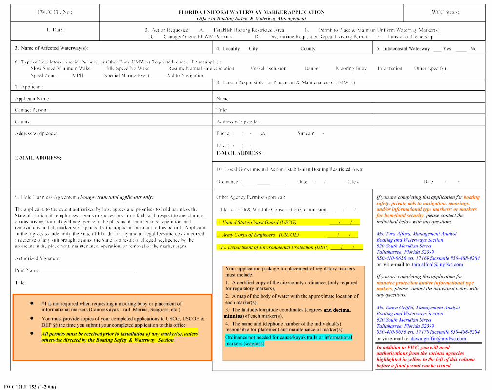
and decimalminutes
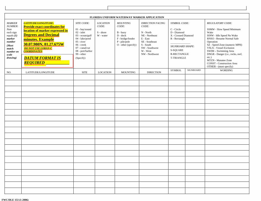
FLORIDA UNIFORM WATERWAY MARKER APPLICATION
MARKER NUMBER: Note each sign equals (1) marker number (Must match number on scale drawing)
LATITUDE/LONGITUDE: Provide exact coordinates for location of marker expressed in
Degrees and Decimal minutes. Example 30.07.980N, 81.27.675W DO NOT USE LORAN-C COORDINATES
SITE CODE: 01 - bay/sound 02 - inlet 03 - ocean/gulf 04 - lake/pond 05 - river 06 - creek 07 - canal/cut 08 - port/harbor 99 - other (Specify)
LOCATION CODE: S - shore W - water
MOUNTING CODE: B - buoy D - dock F - bridge/fender P - pile/pole O - other (specify)
DIRECTION FACING CODE: N - North NE - Northeast E - East SE - Southeast S - South SW - Southwest W - West NW - Northwest
SYMBOL CODE: C - Circle D - Diamond X - Crossed Diamond R - Rectangle _______________ SIGNBOARD SHAPE: S-SQUARE R-RECTANGLE T-TRIANGLE
REGULATORY CODE: SSMW - Slow Speed Minimum Wake ISNW - Idle Speed No Wake RNSO - Resume Normal Safe Operation SZ - Speed Zone (numeric MPH) VSLX - Vessel Exclusion SWIM – Swimming Area DNGR - Danger (i.e., rocks, reef, etc.) MTZN - Manatee Zone CONST - Construction Area OTHER - (must specify)
NO.
LATITUDE/LONGITUDE
SITE
LOCATION
MOUNTING
DIRECTION
SYMBOL
SIGNBOARD
WORDING
DATUM FORMAT IS REQUIRED ____________
FWC/DLE 153 (1-2006)

For updates visit www.MyFWC.com/boating
Chapter 68C-22 Florida Administrative Code
Appendix D
- 7
CHAPTER 68C-22 THE FLORIDA MANATEE SANCTUARY ACT
68C-22.001 Scope and Purpose.68C-22.002 Definitions.68C-22.003 Regulated Activities.68C-22.004 Management Provisions.68C-22.005 Lee County Zones.68C-22.006 Brevard County Zones.68C-22.007 Indian River County Zones.68C-22.008 St. Lucie County Zones.68C-22.009 Palm Beach County Zones.68C-22.010 Broward County Zones.68C-22.011 Citrus and Associated County (Parts of Levy and Hernando) Zones.68C-22.012 Volusia and Associated County (Parts of Putnam, Lake, Seminole and Flagler) Zones.68C-22.013 Hillsborough County Zones.68C-22.014 Manatee County Zones.68C-22.015 Charlotte County (and Part of DeSoto County) Zones. 68C-22.016 Pinellas County Zones.68C-22.018 Turkey Creek Zones Established. (Repealed)68C-22.021 Manatee Cove Zone Established. (Repealed)68C-22.022 Hillsborough County - Big Bend Zones Established. (Repealed)68C-22.023 Collier County Zones.68C-22.024 Martin County Zones.68C-22.025 Dade County Zones.68C-22.026 Sarasota and Associated County (Parts of Manatee and Charlotte) Zones.68C-22.027 Duval County and Associated County (Parts of Clay and St. Johns) Zones.
68C-22.001 Scope and Purpose.(1) This rule chapter implements Section 370.12(2), F.S., (the Florida Manatee Sanctuary Act) by establishing restrictions to
protect manatees from harmful collisions with motorboats and from harassment; to protect manatee habitat, such as seagrass beds,from destruction by boats or other human activity; and to provide limited safe havens where manatees can rest, feed, reproduce,give birth or nurse undisturbed by human activity. The Commission shall only regulate motorboat speed and operation in areaswhere manatees are frequently sighted and the best available scientific information, as well as other available, relevant, and reliableinformation supports the conclusion that manatees inhabit such areas on a regular or periodic basis. Information considered by theCommission may include but is not limited to manatee surveys, observations, available studies of food sources, and water depths.
(2) When establishing manatee protection zones as provided above, the Commission shall utilize the standards provided underparagraph (2)(a), below, in determining whether restrictions are necessary to protect manatees or manatee habitat. The Commissionshall not establish restrictions that result in undue interference with the rights of fishers, boaters, and water skiers (as they applyunder Section 370.12(2)(k), F.S.).
(a) The Commission utilizes the following standards in determining whether restrictions are necessary to protect manatees ormanatee habitats in areas of regular or periodic manatee use:
1. Restrictions are necessary if the absence of adequate restrictions will likely result in:a. Injury or death to manatees; orb. Harassment of manatees; orc. Destruction of essential manatee habitat.2. In determining whether restrictions are necessary, the Commission will consider, but not be limited to an examination of, the
following factors:a. The patterns and intensity of known boating activities in the area;b. Seasonal and/or year-round patterns of manatee use;c. The number of manatees that the Commission has concluded use the area on a regular or periodic basis;d. The manatee mortality trends within the area;e. The existence of features within the area that are essential to the survival of, or are known to attract, manatees, such as
seagrasses or other food sources, favorable water depths, and fresh or warm water sources; f. The characteristics of the waterway; andg. Whether the Commission’s measurable biological goals that define manatee recovery are being achieved in the region that is
being considered.(b) Regarding the measurable biological goals referenced in paragraph (2)(a), above, in regions where the goals are being
achieved, the Commission shall give great weight to existing state manatee protection rules; however, the Commission may amendexisting rules or adopt new rules in these areas to address risks or circumstances in a particular area or water body.
- 8
(c) In consideration of balancing the rights of fishers, boaters, and water skiers to use waters for recreational and commercialpurposes (as applicable under Section 370.12(2)(k), F.S.), with the necessity for boat speed regulation to protect manatees andmanatee habitat in identified manatee use areas, the Commission may designate limited lanes or corridors to provide for reasonablemotorboat speeds (25 mph or greater) or not regulate sufficient portions in order to accommodate activities that require higherspeeds, upon a finding that such lanes, corridors, or areas are consistent with manatee protection needs.Specific Authority 370.12(2)(g)-(j), (l), (n), (o), 372.072(6) FS. Law Implemented 370.12(2)(d), (g)-(l), (n), (o), 372.072(6) FS. History–New3-19-79, Formerly 16N-22.01, Amended 12-30-86, 6-16-93, 9-9-93, Formerly 16N-22.001, Amended 5-31-95, 6-25-96, 5-12-98, Formerly62N-22.001, Amended 12-23-03, 11-8-05.
68C-22.002 Definitions.When used in these rules, the following words shall have the indicated meanings unless the context clearly indicates otherwise:
(1) “Idle Speed” and “Idle Speed No Wake” may be used interchangeably and mean that a vessel must proceed at a speed nogreater than that which will maintain steerageway and headway. At no time is any vessel required to proceed so slowly that theoperator is unable to maintain control over the vessel or any other vessel or object that it has under tow.
(2) “Miles” means statute miles.(3) “Motorboats prohibited zone” as used in Chapter 68C-22, F.A.C., is synonymous with the definition of the “no
power-driven vessels” zone defined in paragraph 68D-23.103(2)(d), F.A.C., and means that all vessels equipped with anymechanical means of propulsion are prohibited from entering the marked area unless the mechanical means of propulsion is not inuse and, if possible to do so, is tilted or raised out of the water.
(4) “Slow Speed” and “Slow Speed Minimum Wake” may be used interchangeably and mean that a vessel must be fully offplane and completely settled into the water. The vessel must then proceed at a speed which is reasonable and prudent under theprevailing circumstances so as to avoid the creation of an excessive wake or other hazardous condition which endangers or is likelyto endanger other vessels or other persons using the waterway. Due to the different speeds at which vessels of different sizes andconfigurations may travel while in compliance with this definition, there is no specific numerical speed assigned to Slow Speed. Avessel that is:
(a) Operating on plane is not proceeding at this speed;(b) In the process of coming off plane and settling into the water or coming up onto plane is not proceeding at this speed;(c) Operating at a speed that creates an excessive wake or other hazardous condition which unreasonably or unnecessarily
endangers other vessels or other persons using the waterway, or is likely to do so, is not proceeding at this speed;(d) Completely off plane and which has fully settled into the water and is proceeding at a reasonable and prudent speed with
little or no wake is proceeding at this speed.(5) “Maximum 25 MPH Speed Zone” means a controlled area within which a vessel’s speed made good over the bottom,
measured in statute miles, shall not exceed 25 miles per hour. Although it is the intention of the Commission to allow those vesselscapable of attaining a planing configuration at 25 MPH to do so, this speed limit shall not be construed as permitting the reckless orcareless operation of a vessel, in violation of Section 327.33, F.S., or authorizing any vessel to travel at an unsafe speed, in violationof navigation rule 6, as adopted pursuant to Section 327.33, F.S., by reason of:
(a) Having an elevated bow which restricts visibility, or(b) Producing an excessive wake or other hazardous condition that endangers or is likely to endanger other vessels, other
persons using the waterway, or natural resources of the state.(6) “Maximum 30 MPH Speed Zone” means a controlled area within which a vessel’s speed made good over the bottom,
measured in statute miles, shall not exceed 30 miles per hour. Although it is the intention of the Commission to allow those vesselscapable of attaining a planing configuration at 30 MPH to do so, this speed limit shall not be construed as permitting the reckless orcareless operation of a vessel, in violation of Section 327.33, F.S., or authorizing any vessel to travel at an unsafe speed, in violationof navigation rule 6, as adopted pursuant to Section 327.33, F.S., by reason of:
(a) Having an elevated bow which restricts visibility, or(b) Producing an excessive wake or other hazardous condition that endangers or is likely to endanger other vessels, other
persons using the waterway, or natural resources of the state.(7) “Maximum 35 MPH Speed Zone” means a controlled area within which a vessel’s speed made good over the bottom,
measured in statute miles, shall not exceed 35 miles per hour. Although it is the intention of the Commission to allow those vesselscapable of attaining a planing configuration at 35 MPH to do so, this speed limit shall not be construed as permitting the reckless orcareless operation of a vessel, in violation of Section 327.33, F.S., or authorizing any vessel to travel at an unsafe speed, in violationof navigation rule 6, as adopted pursuant to Section 327.33, F.S., by reason of:
(a) Having an elevated bow which restricts visibility, or(b) Producing an excessive wake or other hazardous condition that endangers or is likely to endanger other vessels, other
persons using the waterway, or natural resources of the state.(8) “Shoreline” means the point where the water meets the land at any point in time.
- 9
(9) “General Contour of the Shoreline” means a line defined as the most waterward of the outside edge of emergent aquaticvegetation, if present, or a line of Mean Low Water as defined in Chapter 177, Part II, F.S., as approximated on NOAA nauticalcharts. Waters lying landward of this line are to be included up to the shoreline, as defined under subsection (8), above. Emergentaquatic vegetation shall include plants rooted in the ground that extend above the surface of the water.
(10) “Channel” means a navigation route that is marked by aids to navigation that have been authorized by permits issued byall required state and federal authorities.
(11) “No Entry Zone” or “No Entry Area” means a controlled area where all vessels and all persons, either in vessels orswimming, diving, wading, or fishing (except from an adjacent bank or bridge when using poles or lines which are not equippedwith a fishing line retrieval mechanism, e.g., a cane pole) are prohibited from entering.
(12) “Authorized Resident” means any person owning a fee or leasehold interest in real property or a boating facilityimmediately adjacent to a motorboats prohibited zone or a no entry zone.
(13) “Rights of Fishers, Boaters, and Water Skiers” (as they apply under Section 370.12(2)(k), F.S.), means that fishers,boaters, and water skiers have the right to use the waters of the State of Florida for recreational or commercial purposes in a mannerconsistent with all applicable federal, state and local laws and regulations. Such laws and regulations include, but are not limited to,those governing the operation and safety of vessels on the water to promote public safety, environmental/natural resourceprotection, and/or responsible use of the waters of the State.
(14) “Undue Interference” with the rights of fishers, boaters, and water skiers (as it applies under Section 370.12(2)(k), F.S.)occurs:
(a) If the Commission regulates boat speeds generally throughout the waters of the state; or(b) If the Commission establishes regulations that encompass a larger geographic area or time frame than is warranted; set
speed limits that are more restrictive than are warranted; encompass an area where the Commission has not determined thatrestrictions are necessary to protect manatees or manatee habitat pursuant to paragraph 68C-22.001(2)(a), F.A.C.; or fail to providelimited lanes or corridors providing for reasonable motorboat speeds, as called for in paragraph 68C-22.001(2)(b), F.A.C.
(15) “Planing” means riding on or near the water’s surface as a result of the hydrodynamic forces on a vessel’s hull, sponsons,foils or other surfaces. A vessel is considered “on plane” when it is being operated at or above the speed necessary to keep thevessel planing.
(16) “Wake” means all changes in the vertical height of the water’s surface caused by the passage of a vessel including, but notlimited to, a vessel’s bow wave, stern wave, and propeller wash.
(17) “Harassment” means any intentional or negligent act or omission which creates the likelihood of causing an injury to amanatee by annoying it to such an extent as to significantly disrupt normal behavioral patterns which include, breeding, feeding orsheltering. The intentional provision of any type of food to manatees not in captivity shall be considered harassment under thisdefinition, unless authorized by a valid federal or state permit.
(18) “Maximum 20 MPH Speed Zone” means a controlled area within which a vessel’s speed made good over the bottom,measured in statute miles, shall not exceed 20 miles per hour. Although it is the intention of the Commission to allow those vesselscapable of attaining a planing configuration at 20 MPH to do so, this speed limit shall not be construed as permitting the reckless orcareless operation of a vessel, in violation of Section 327.33, F.S., or authorizing any vessel to travel at an unsafe speed, in violationof navigation rule 6, as adopted pursuant to Section 327.33, F.S., by reason of:
(a) Having an elevated bow which restricts visibility, or(b) Producing an excessive wake or other hazardous condition that endangers or is likely to endanger other vessels, other
persons using the waterway, or natural resources of the state.Specific Authority 370.12(2)(g)-(j), (l), (n), (o) FS. Law Implemented 370.12(2)(d), (g)-(l), (n), (o) FS. History–New 3-19-79, Amended 11-23-83,Formerly 16N-22.02, Amended 12-30-86, 12-24-90, 12-25-91, 6-16-93, 9-9-93, Formerly 16N-22.002, Amended 5-31-95, 6-25-96, 5-12-98,Formerly 62N-22.002, Amended 12-23-03.
68C-22.003 Regulated Activities.(1) General Guidelines and Application Procedures: This rule sets forth criteria pertaining to the regulation of the speed and
operation of vessel traffic and other activities which are otherwise prohibited by Chapter 68C-22, F.A.C. Permits for such regulatedactivities shall be issued only as provided hereunder. Permits shall be issued only upon a finding by the Commission that activitiesas described in this section will not pose a serious threat to manatees, and that such activities are justified. Determinations ofjustification of need will be made based on the criteria given under each specific subsection. Permits shall not be granted foractivities within “Motorboats Prohibited” or “No Entry” zones, except as explicitly provided for in this section.
(a) In considering applications for permits under this section, a “serious threat to manatees” exists if, due to the nature,location, or frequency of the activity proposed, its conduct can be reasonably expected to result in either (1) injury or death tomanatees, (2) a significant disruption of the manatee’s normal use, behavior or migratory patterns, or (3) disturbance which wouldlead to or cause destruction of essential manatee habitat. In making its determination, the Commission’s examination will includean evaluation of the following factors:
1. Patterns of manatee use of the area, both seasonal and year-round;2. The number of manatees known or assumed to occur in or seasonally use the area;
- 10
3. The manatee mortality trends within the area;4. The existence of features within the area which are essential to the survival of, or are known to attract, manatees, such as
seagrasses or other food sources, favorable water depths, and fresh or warm water sources;5. The cumulative effect of the requested activities in light of other permits previously granted or currently being considered by
the Commission and known vessel traffic patterns and densities in the area; and6. The characteristics of the waterway and of the vessel(s)/motor(s) which would be operated by the applicant.(b) Applications for permits to conduct activities described in this section should be submitted as far in advance of the
requested activities as possible and must be submitted to the Chief of the Office of Environmental Services, Florida Fish andWildlife Conservation Commission, 620 South Meridian Street, Tallahassee, FL 32399. Information which must be submitted isdescribed in each specific subsection. If an application does not contain sufficient information to enable the Office to evaluate therequest, the Office shall request any needed information within 30 days of receipt of the request. The Office shall respond by letter(issuing a permit or denying the request) as quickly as is practical and must respond within 90 days of receipt of all necessaryinformation.
(c) When issuing a permit, the Commission may place conditions on the permit as necessary to protect manatees. Examples oftypes of conditions which may be specified include seasonal constraints, use of screens or barriers, restrictions on types ofpermitted activities, restrictions relative to time of day, day of week, or weather conditions when permits are in effect, use ofspecialized equipment (e.g., propeller guards or jet drives, speedometers) when feasible and such use would not defeat the purposeof the requested activity, additional water quality precautions, sea grass protection or protection of associated marine life orvegetation, temporary marking or permit display, limitations on intensity of activity, pre-activity monitoring, use of manateeobservers, and after-activity reports. The specific conditions, if any, that are placed on a permit will be dependent on the specificsof the request. Acceptance of the permit shall constitute evidence that the recipient agrees to comply with the conditions set forth inthe permit.
(d) The Commission retains the right to modify or rescind a permit should information become available indicating that thepermitted activity is likely to create a serious threat to manatees or that the permit (in its current form) is not needed by therecipient. Before a permit is modified or rescinded, the permit holder shall be given an opportunity to discuss with the Commissionthe reasons for the modification or rescission. Unless an immediate threat to manatees is likely, the Commission shall wait at least30 days after notifying the permit holder before taking action on the permit. If a single manatee is struck or killed by a vesseloperating pursuant to a permit under these provisions, the permit shall be immediately re-evaluated by the Commission todetermine if the permit needs to be modified or rescinded.
(e) Receipt of a permit does not release a holder from the duty to comply with all federal, state, and local regulations (otherthan Chapter 68C-22, F.A.C.), governing the operation of vessels on navigable waterways or pertaining to protection of the WestIndian (Florida) manatee. Permit issuance does not constitute authorization for the recipient to kill, injure, or harass a manateewhile operating under a permit.
(f) Failure to comply with the permit or associated conditions, or any finding of fraudulent use or application for said permit,shall be cause for the immediate revocation of the permit.
(2) Law Enforcement: Any authorized law enforcement officer may engage in any activity otherwise prohibited by Chapter68C-22, F.A.C., if:
(a) The officer is acting in the performance of his or her official duties, and entry into a “Motorboats Prohibited” or “No Entry”zone as defined in Rule 68C-22.002, F.A.C., is reasonably warranted; or
(b) The activity is being conducted to directly protect manatees, to enhance the propagation or survival of manatees, or it isreasonably required to enforce other provisions of Chapter 68C-22, F.A.C.
(3) Emergency Situations: Any person may engage in water-born activity otherwise prohibited by Chapter 68C-22, F.A.C., ifsuch activity is reasonably necessary to prevent the loss of life or property due to emergency circumstances, or to render emergencyassistance.
(4) General Activities: For the purpose of issuing authorizations to allow the performance of certain activities which areotherwise prohibited by Chapter 68C-22, F.A.C., (including activities prohibited by “Motorboats Prohibited” or “No Entry” zonesas defined in Rule 68C-22.002, F.A.C., as provided in subsection (1), permits shall be issued by the Commission only upon both ashowing of a justification of need by the applicant and a determination of an absence of serious threat to manatees in associationwith the requested activity. Permits shall only be issued for activities which: are necessary to carry out a prerequisite of permittingby federal, state, or local governments (or are a condition to or are otherwise authorized by a valid permit), are necessary for habitatrestoration or environmental protection purposes, are necessary for other scientific or educational purposes or for the enhancementof propagation or survival of the manatee, or are necessary for purposes of construction, maintenance, or repair to adjacent propertyowner’s facilities including maintenance dredging and debris removal. Permitted activities may not, either intentionally ornegligently, molest, harass, collide with, injure or harm manatees. When operating under a permit within “Motorboats Prohibited”or “No Entry” zones, vessels shall be operated at no greater than idle speed.
(a) Permits are non-transferable and shall only be considered upon written application as specified hereunder. Copies of anyassociated permits must be submitted with the request. The application must, at a minimum, contain enough information todemonstrate:
- 11
1. The nature and scope of the activity to be conducted within the restricted area, including the number of vessels to beinvolved, the type and configuration of the vessels, and the maximum speeds necessary;
2. The specific area within which the activity would be conducted, described in the application and depicted on a nauticalchart;
3. The period of time for which the permit is needed, limited to specific dates if possible; and4. Justification for conducting the activity within waters regulated for manatee protection, clearly demonstrating why an
alternative site is unsuitable or unavailable.(b) Permits granted under the provisions of this subsection shall be effective only for the time period specified in the permit,
and only in the areas specified in the notice.(5) Resident Access to Limited Entry Areas: Any authorized resident or his/her guests who must cross a “Motorboats
Prohibited” or “No Entry” zone as defined in Rule 68C-22.002, F.A.C., for the sole purpose of water access by boat to privateresidences, boat houses, or boat docks, shall be authorized access by obtaining and affixing an identifying insignia to his/her vessel.Motorboats shall be operated at no greater than idle speed while within the zone.
(a) To obtain authorization, authorized residents must submit a signed letter providing the following information anddocumentation:
1. The name, mailing address, and telephone number of the authorized resident;2. A description of the vessel(s) to be permitted, including a copy(ies) of the current vessel registration(s);3. A map showing the location of the property to which access is required in relation to the “No Entry” or “Motorboats
Prohibited” zone;4. Verification of property ownership, rental or lease. For property owners, acceptable forms of verification include the
property’s tax assessment, a current utilities or telephone bill, or a mortgage agreement. For residents renting or leasing theproperty, acceptable forms of verification include the rental or lease agreement, or a current utilities or telephone bill. To beacceptable, the document used for verification must be in the authorized resident’s name.
(b) Upon review and approval of the application by the Office of Environmental Services, an identifying decal or other insigniashall be issued, free of charge, to authorized residents. (Two (2) insignias or decals per authorized resident shall also be issued freeof charge for use by authorized guests, with additional guest decals available upon justification of need).
(6) Commercial Fishing and Professional Guiding: The following provisions pertain to qualifying commercial fishermen andprofessional fishing guides. In those speed zones wherein such intent was provided and specified at the time of zone establishmentand as provided in subsection (1), permits shall be issued by the Commission only upon both a showing of a justification of need bythe applicant and a determination of an absence of serious threat to manatees in association with the requested activity.
(a) In considering applications for permits under this subsection, a justification of need will be based on a finding of hardship.A hardship will be found to exist if an applicant can demonstrate the following:
1. Commercial fishing or professional guiding, as appropriate, is either:a. The applicant’s principal occupation, in that a majority of the applicant’s work week is spent in pursuit of that occupation; orb. A significant source of income for the applicant, in that a minimum of 25% of the applicant’s gross annual income is
attributable to revenue derived from that occupation;2. The applicant’s customary fishing or guiding practices would be significantly curtailed as a result of the restrictions for
which a permit is sought in that at least 25% of the applicant’s gross annual income would be lost if a permit is not granted becausesufficient alternative sites or methods for carrying out the activity in question are not available to the applicant; and
3. The applicant’s compliance with the restrictions for which a permit is sought will result in a significant economic or physicalburden being borne by the applicant.
(b) Upon a determination by the Office of Environmental Services that such a permit will not result in serious threats tomanatees and that a hardship exists as a result of the speed restrictions imposed, commercial fishermen fulfilling the followingrequirements shall be granted a permit;
1. Possession of a current Saltwater Products License issued pursuant to Section 370.06, F.S., or of an equivalent freshwaterlicense issued pursuant to Section 372.65, F.S., (if only freshwater species are taken), a current commercial vessel registration, andany other license(s) as may be required of commercial fishermen to operate within the particular county in which a permit issought; and;
2. Completion of the permit application referenced in paragraph (6)(d) hereunder, including submittal of copies of alldocuments required in subparagraph (b)1., above.
(c) Upon a determination by the Office of Environmental Services that such a permit will not result in serious threats tomanatees and that a hardship exists as a result of the speed restrictions imposed, professional fishing guides fulfilling the followingrequirements shall be granted a permit:
1. Possession of a current commercial vessel registration;2. Possession of a current license from the U.S. Coast Guard authorizing the carriage of passengers for hire on the waters for
which the permit is sought;3. Possession of a current saltwater fishing license in accordance with Section 370.0605, F.S., for vessels carrying customers
wherein a fee is paid directly or indirectly (if saltwater species are taken);
- 12
4. Possession of other current occupational license(s) as may be required of professional fishing guides to operate within theparticular county in which the permit is sought; and
5. Completion of the permit application referenced in paragraph (6)(d) hereunder, including submittal of copies of alldocuments required in subparagraphs (c)1. through (c)4., above.
(d) A permit application form (“Application for Permit, Manatee Protection Zones”), Form No. FWC 68C-22.003-6 (6/96),which is hereby incorporated by reference, may be obtained from the Fish and Wildlife Conservation Commission, Office ofEnvironmental Services, 620 South Meridian Street, Tallahassee, FL 32399, or from the Division of Law Enforcement office asdesignated under specific manatee protection zone rule provisions. The form shall include items for completion by commercialfishermen and professional fishing guides, imparting information necessary: (1) to show a justification of need by the applicant;and (2) for the Commission to make a determination as to the potential impacts of allowing the requested activities within specifiedregulated areas.
(e) Acceptance of a permit shall constitute evidence that the recipient agrees to maintain speeds of 20 mph or less at all timeswhile operating under a permit within the restricted area and to comply with any and all conditions set forth within the permit.(Examples of other types of conditions which may be specified to promote manatee protection are described in subsection68C-22.003(1), F.A.C.)
(f) Permits granted under the provisions of this section shall be effective only for the time period specified in the permit, andonly in the areas specified in the notice. Permits may only be utilized by the fisherman or guide in whose name it is issued, onlywhile aboard the vessel identified on the permit, and only when engaged in their customary fishing or guiding practices, asapplicable. For guides, permits apply only when paying customers are aboard.
(7) Testing of Motors or Vessels by Manufacturers: The following provisions pertain to boat motor and vessel testingoperations by manufacturers. As provided in subsection (1), permits shall be issued by the Commission only upon both a showingof justification of need by the applicant and a determination of an absence of serious threat to manatees in association with therequested activity. Permits shall be in effect for five (5) years, or for a shorter period if requested by the applicant, and shall only beissued upon written application as specified within paragraph (7)(a) hereunder. Permits are non-transferable and shall only beissued from speed restrictions appearing in Chapter 68C-22, F.A.C., which were established after June 1, 1990.
(a) Permits shall be granted only upon:1. Submission of a request in writing to the Office of Environmental Services clearly stating:a. The geographic areas within which testing is to be conducted (The written description shall be accompanied by navigational
charts or boater guide maps clearly indicating the proposed test course location and route);b. The types of vessels/motors to be tested;c. The estimated number of motors or vessels to be tested annually;d. The estimated maximum number of motors or vessels to be tested at any one time within the restricted area;e. The estimated maximum speeds at which vessels will travel during the tests; andf. The estimated number of qualified employees to work as vessel operators, and a brief description of their qualifications.2. Submission of a statement of justification of need to utilize specific waterways or specific portions of waterways within
areas for which manatee speed zone protection has been established, clearly demonstrating a substantial hardship (economic,operational or other) to the manufacturer. Such a statement must detail why, and under what circumstances, other waters areinappropriate for such testing purposes.
(b) Acceptance of a permit shall constitute evidence that the recipient (and his/her authorized employees) agrees to:1. Carry on the vessel a copy of the permit and, an identification as an employee of a corporation or firm actively engaged in
the manufacture of boat motors or vessels;2. Unless otherwise provided in the permit, operate only between sun-up and sundown, Monday through Friday, and sun-up
Saturday through noon, not on Sundays or on state-recognized holidays; and3. Comply with any and all conditions set forth in the permit. (Examples of other types of conditions which may be specified to
promote manatee protection are described in subsection 68C-22.003(1), F.A.C.)(c) For the purposes of this rule, the following definitions shall apply:1. Testing – The act by a manufacturer of evaluating a boat motor or vessel for the purposes of determining its operational
characteristics. Such operational characteristics shall include, but not be limited to, those pertaining to product designs, endurance,performance, and safety.
2. Boat motor manufacturer – An entity engaged in the production of boat motors from basic components for the purpose ofsale.
3. Vessel manufacturer – An entity engaged in the production of vessels from basic components for the purpose of sale.4. Vessel – Vessel is synonymous with boat, as referenced in Section 1(b), Article VII, of the State Constitution, and includes
every description of watercraft, barge, and airboat other than a seaplane on the water used or capable of being used as a means oftransportation on water.
(8) Resident Access Through Speed-controlled Areas: For the sole purpose of allowing ingress and egress to persons who musttravel through speed zones established under Chapter 68C-22, F.A.C., to access private residences, boat houses, or boat docks,except as provided under subsections (4) and (5) above, who would otherwise be physically precluded water access because of
- 13
speed restrictions (such that shoaling or other physical factors would require residents to exceed such speed restrictions), theCommission shall grant a non-transferable resident permit upon a demonstration of just cause, as set forth in paragraph (8)(a)hereunder, and upon a finding that issuance of such a permit will not pose a serious threat to manatees.
(a) The Office of Environmental Services, upon review by the Division of Law Enforcement, will consider a request for such aresident permit upon the receipt of a signed explanatory letter of intent from the affected resident clearly demonstrating:
1. The need to exceed speed restrictions for ingress and egress purposes;2. Justification for traveling at speeds greater than those established within designated zone on the basis of vessel and boat
motor types/horsepower;3. Evidence of property ownership or residency in said property;4. Areas, as marked on an accompanying map and clearly described with permanent landmarks, where shoaling or other
physical circumstances warrant exception to restrictive provisions, and the minimum area/distance required for travel at speedsgreater than those established within the designated zone; and
5. Description(s) and vessel registration number(s) for vessel(s) owned by said resident for which a permit is requested.(b) Acceptance of a permit shall constitute evidence that the recipient agrees to maintain speeds of 25 MPH or less at all times
while operating under a permit unless otherwise provided in the permit, to hold said permit on the vessel at all times, and to complywith any and all conditions set forth within the permit. (Examples of other types of conditions which may be specified to promotemanatee protection are described in subsection 68C-22.003(1), F.A.C.)
(c) Permits granted under the provisions of this subsection shall be effective only for the time period specified in the permit,and only in the areas specified in the notice.
(d) If the area for which a permit has been issued is dredged, the permit recipient shall so notify the Commission.(9) Boat Races: The following provisions pertain to powerboat racing. In those speed zones wherein such intent was provided
and specified at the time of zone establishment and as provided in subsection (1), permits shall be issued by the Commission onlyupon both a showing of a justification of need by the applicant and a determination of an absence of serious threat to manatees inassociation with the requested activity. Permits are non-transferable and shall only be considered upon written application asspecified hereunder.
(a) The application must, at a minimum, contain enough information to demonstrate:1. The nature and scope of the racing event, including estimated numbers of vessels to be involved, the nature and
configuration of the vessels, and the maximum speeds anticipated;2. The specific area within which the racing event is requested, described in the application and depicted on a nautical chart;3. The intended date(s) of the racing event; and4. Justification for holding the racing event within waters regulated for manatee protection, clearly demonstrating why an
alternative site is unsuitable or unavailable.(b) Failure to comply with the permit or associated conditions, or any finding of fraudulent use or application for said permit,
shall be cause for the immediate revocation of the permit, including suspension of permit privileges prior to or during the permittedevent. (Examples of types of conditions which may be specified to promote manatee protection are described in subsection68C-22.003(1), F.A.C.)
(c) If a single manatee is struck or killed by a vessel operating above the posted speed limit pursuant to a permit under theseprovisions, the permit shall be automatically and immediately rescinded.
(d) Permits granted under the provisions of this subsection shall be effective only for the time period specified in the permit,and only in the areas specified in the permit.Specific Authority 370.12(2)(f)-(i), (k), (n), (o) FS. Law Implemented 370.12(2)(d), (f)-(k), (m), (n), (o) FS. History–New 3-19-79, Formerly16N-22.03, Amended 12-30-86, 8-28-90, 12-25-91, 6-16-93, Formerly 16N-22.003, Amended 6-25-96, 5-12-98, Formerly 62N-22.003.
68C-22.004 Management Provisions.Regulations established pursuant to Section 370.12(2), F.S., and Rule 68C-22.001, F.A.C., shall be marked by regulatory markersthat conform to Chapter 68D-23, F.A.C., Uniform Waterway Markers in Florida Waters. Where conflicting speed or operationalrestrictions are established by law or pursuant to law, the more restrictive shall be posted and shall apply.Specific Authority 370.12(2)(g)-(j), (l), (n), (o) FS. Law Implemented 370.12(2)(g)-(l), (n), (o) FS. History–New 3-19-79, Formerly 16N-22.04,Amended 12-30-86, 12-25-91, Formerly 16N-22.004, 62N-22.004, Amended 12-23-03.
68C-22.005 Lee County Zones.(1) The Commission hereby designates the waters within Lee County, as described below, as areas where manatee sightings are
frequent and where the best available information supports the conclusion that manatees inhabit these areas on a regular or periodicbasis. The primary purpose of this rule is to protect manatees from harmful collisions with motorboats and from harassment byregulating the speed and operation of motorboats within these designated areas. A secondary purpose is to protect manatee habitat.In consideration of balancing the rights of fishers, boaters, and water skiers to use the waters of the state for recreational andcommercial purposes (as applicable under Section 370.12(2)(k), F.S.), with the need to provide manatee protection, the

For updates visit www.MyFWC.com/boating
Chapter 68D-23 Florida Administrative Code
Appendix E
CHAPTER 68D-23 UNIFORM WATERWAY MARKERS IN FLORIDA WATERS 68D-23.003 Placement of Regulatory Markers in Waters of the State. (Repealed) 68D-23.101 Intent. 68D-23.102 Scope. 68D-23.103 Definitions. 68D-23.104 Placement of Markers. 68D-23.105 Criteria for Approval of Regulatory Markers. 68D-23.106 Market Placement Conditions. 68D-23.107 Federal System Adopted. 68D-23.108 Specifications for Markers. 68D-23.109 Additional Specifications for Information and Regulatory Markers. 68D-23.110 Inspection and Certification. 68D-23.111 Enforcement. 68D-24.112 Exemptions. 68D-23.101 Intent. (1) This Chapter is consistent with and conforms to 33 C.F.R. part 62 – The navigable waters of the United States and non-navigable State waters (which together include all waters of this state), are marked to assist navigation using the United States Aids to Navigation System, a system consistent with the International Association of Lighthouse Authorities (IALA) Maritime Buoyage System. The IALA Maritime Buoyage System is followed by most of the world’s maritime nations and will improve maritime safety by encouraging conformity with buoyage systems used worldwide. (2) It is the intent of this chapter: (a) To provide for uniformity in design, construction and coloring of markers so that all vessel operators may readily recognize, identify and distinguish between authorized markers and unlawfully placed markers; (b) To provide a means by which the Division and its officers and all other law enforcement officers charged with the enforcement of this chapter may determine with reasonable certainty which boating restricted areas are lawfully established and marked; (c) To insure that regulatory markers noticing boating restricted areas created pursuant to Sections 327.22, 327.60 and 370.12, F.S., are authorized only for the purposes of protecting human life and limb, vessel traffic safety and maritime property, and manatees. (3) It is further the intent of this chapter that no boating restricted area be established, continued in effect, or enforced for the purpose of noise abatement or for the protection of shoreline, shore-based structures, or upland property from vessel wake or shoreline wash. As provided in Section 327.33(2), F.S., “vessel wake and shoreline wash resulting from the reasonable and prudent operation of a vessel shall, absent negligence, not constitute damage or endangerment to property.” The wake resulting from the reasonable and prudent operation of a vessel is a force which should be anticipated by the owners of property adjacent to the navigable waters of this state. (4) The Division will not issue any permit authorizing the placement of regulatory markers for: (a) Ordinances that apply within the Florida Intracoastal Waterway, in violation of Section 327.60(2), F.S.; (b) Ordinances adopted pursuant to Section 370.12(2)(p), F.S., until such ordinances have been reviewed and approved by the commission, and provided that such ordinances do not apply within the marked navigation channel of the Florida Intracoastal Waterway nor to the waters within 100 feet of said channel; (c) Ordinances that discriminate against personal watercraft, in violation of Section 327.60(1), F.S.; (d) Ordinances that discriminate against airboats, unless adopted by a two-thirds vote of the governing body enacting such ordinance, as provided in Section 327.60(1), F.S. (e) Ordinances regulating the anchoring of non-live-aboard vessels in navigation, in violation of Section 327.60(2), F.S., when such vessels are outside the marked boundaries of mooring fields permitted as provided in Section 327.40, F.S., and this rule. (5) Where conflicting speed or operational restrictions are established by law or pursuant to law, the more restrictive shall be posted and shall apply. (6) Regulatory markers placed pursuant to a permit issued as provided herein shall be prima facie evidence of the boundaries of boating restricted areas and the speed or operational restrictions imposed therein. Specific Authority 327.04, 327.40, 327.41 FS. Law Implemented 327.40, 327.41 FS. History–New 12-23-01, Amended 10-5-06.
68D-23.102 Scope. The provisions of this chapter prescribe the procedures by which the Division permits and regulates the placement of markers in, on, and over the waters of this state and the shores thereof. This chapter also provides for the design, construction, characteristics and coloring of all markers placed in, on, and over the waters of this state and the shores thereof by adopting by reference the United States Aids to Navigation System, Part 62 of Title 33 of the Code of Federal Regulations. Specific Authority 327.40, 327.41 FS. Law Implemented 327.40, 327.41 FS. History–New 12-23-01. 68D-23.103 Definitions. (1) For purposes of this chapter and Chapters 68C-22 and 68D-24, F.A.C., the following definitions shall apply: (a) “Aid to navigation” means any device external to a vessel intended to assist a navigator to determine position or safe course, or to warn of dangers or obstructions to navigation. (b) “Information marker” means a device external to a vessel intended to provide the mariner with information concerning matters other than dangers or obstructions to navigation, or regulatory matters. (c) “Regulatory marker” means a device used to alert the mariner to various warnings or regulatory matters such as horsepower, speed, or wake restrictions. (d) “Mooring buoy” means a device that is permanently secured to the bottom of a body of water and to which a vessel may be secured when not underway. (e) “Buoy” means any device designed to float which is anchored in the waters of the state and which is used to convey a message or carry a sign. (f) “Sign” means an object which displays a message and which is attached to another object such as a piling, buoy, structure, or the land itself. (g) “Symbol” means the orange geometric shape displayed on an information or regulatory marker. The meanings associated with the orange geometric shapes are as follows: 1. A vertical open-faced diamond signifies danger; 2. A vertical diamond shape having a cross centered within indicates that all vessels or certain classes of vessels are excluded from the marked area; 3. A circular shape indicates that certain operating restrictions are in effect within the marked area; and 4. A square or rectangular shape will contain directions or instructions lettered within the shape. (h) “Display area” means the area on an information marker or regulatory marker within which the symbol is displayed. (i) “Boating restricted area” means an area of the waters of the state within which the operation of vessels is subject to specified restrictions or from which vessels are excluded. (j) “Shore” means that area of land immediately adjacent or contiguous to the waters of the state such that a sign or marker erected thereon is readily visible to the operator of a vessel who might reasonably believe that the sign or marker displays navigational, regulatory or other information relevant to the operation of the vessel. (k) “Florida Intracoastal Waterway” means: 1. All waters within the right-of-way of the Atlantic Intracoastal Waterway, the Georgia state line north of Fernandina to Miami; the Port Canaveral lock and canal to the Atlantic Intracoastal Waterway; the Atlantic Intracoastal Waterway, Miami to Key West; the Okeechobee Waterway Route 1 across Lake Okeechobee; the Gulf Intracoastal Waterway, Anclote to Fort Myers; the Gulf Intracoastal Waterway, Carrabelle to Tampa Bay; the Gulf Intracoastal Waterway, Carrabelle to Anclote open bay section (using the Gulf of Mexico); and the Gulf Intracoastal Waterway, Carrabelle to the Alabama state line west of Pensacola; and 2. All waters from shoreline to shoreline within the Okeechobee Waterway, Stuart to Fort Myers, not including Route 1 across Lake Okeechobee; the St. Johns River, Jacksonville to Sanford; and, the Apalachicola, Chattahoochee, and Flint Rivers in Florida. (l) “Uniform State Waterway Marking System” means the system of aids to navigation, information markers, regulatory markers, and mooring buoys, as specified in Part 66 of Title 33 of the Code of Federal Regulations.
(m) “United States Aids to Navigation System” means the system of aids to navigation, information markers, regulatory markers, and mooring buoys, as specified in Part 62 of Title 33 of the Code of Federal Regulations. (n) “Private Aid to Navigation” means an aid to navigation the establishment of which is authorized by a permit issued by the United States Coast Guard pursuant to Part 66 of Title 33 of the Code of Federal Regulations. (o) “Maritime property” means vessels and their engines, tackle, gear, equipment, appurtenances, furnishings, cargoes, stores, personal property then on board belonging to the vessels’ occupants, and such other similar property as is consistent with the general maritime law of the United States. This definition does not include littoral or riparian property, the shores thereof, seawalls, docks, wharfs, or other property intentionally and permanently attached to the shore. (p) “Inland lake” means a naturally occurring or man-made fresh water lake or pond. The term does not include reservoirs, impoundments, or any portion of the Florida Intracoastal Waterway. (q) “Associated canal” means a man-made canal that is directly attached to an inland lake and that does not connect to other waters or that connects only to another inland lake. The term does not include any portion of a state or federally funded navigation project or any portion of the Florida Intracoastal Waterway. (r) “In writing” means any written or printed form of communication and includes electronic mail, files transferred as attachments to electronic mail, and telefacsimiles. (2) When used on markers, the terms: (a) “Idle Speed No Wake” and “Idle Speed” may be used interchangeably and mean that a vessel must proceed at a speed no greater than that which will maintain steerageway and headway. At no time is any vessel required to proceed so slowly that the operator is unable to maintain control over the vessel or any other vessel or object that it has under tow. (b) “Slow Speed” and “Slow Speed Minimum Wake” may be used interchangeably and mean that a vessel must be fully off plane and completely settled into the water. The vessel must then proceed at a speed which is reasonable and prudent under the prevailing circumstances so as to avoid the creation of an excessive wake or other hazardous condition which endangers or is likely to endanger other vessels or other persons using the waterway. A vessel that is: 1. Operating on plane is not proceeding at this speed; 2. In the process of coming off plane and settling into the water or coming up onto plane is not proceeding at this speed; 3. Operating at a speed that creates a wake which unreasonably or unnecessarily endangers other vessels or other persons using the waterway, or is likely to do so, is not proceeding at this speed; 4. Completely off plane and which has fully settled into the water and is proceeding at a reasonable and prudent speed with little or no wake is proceeding at this speed. “Slow Speed” and “Slow Speed Minimum Wake” are the preferred terms. “Slow Down Minimum Wake” markers may continue to be used for restricted areas authorized prior to January 1, 2001, except when such a restricted area is contiguous to an Idle Speed No Wake boating restricted area. (c) “Caution zone” means an area presenting a significant risk of navigational hazard, an area frequently inhabited by manatees on a somewhat regular basis, or other area similarly requiring that vessels be operated with particular alertness and caution so as to avoid endangering life, limb, vessel traffic safety or maritime property, or manatees. (d) “No Power-driven Vessels” – All vessels equipped with any mechanical means of propulsion must turn off the mechanical means of propulsion and, if possible to do so, tilt or raise the mechanical means of propulsion out of the water. (e) “No Internal Combustion Motors” or “No Motor Zone” – All vessels equipped with internal combustion motors (e.g.: gasoline or diesel motors) for propulsion must turn off the internal combustion motor and, if possible to do so, tilt or raise the internal combustion motor out of the water. The use of electric motors is not prohibited. (f) “Vessel exclusion zone” means an area from which all vessels or certain classes of vessels are excluded. The following list includes the most common examples of vessel exclusion zones. Whenever the following messages are displayed on vessel exclusion zone markers, they have the meaning provided. Other messages on vessel exclusion zone markers are permissible, so long as the markers display language that accurately describes the vessels or classes of vessel that are excluded from the area. All vessel exclusion zones must be marked with the crossed-diamond symbol as specified in subparagraph (1)(g)2., above. 1. “No Vessels” or “Swim Area” – All vessels of any type are prohibited from entering the marked area.
2. “No Motorized Vessels” or “No Motorboats” or “Motorboats Prohibited” – All vessels equipped with any mechanical means of propulsion are prohibited from entering the marked area, even if the mechanical means of propulsion is not in use. 3. “Manually Propelled Vessels Only” – All vessels other than those propelled by oars, paddles, or poles are prohibited from entering the marked area. Vessels equipped with sails or a mechanical means of propulsion may enter the marked area only if the sails or mechanical means of propulsion is not in use and, if possible to do so, the mechanical means of propulsion is tilted or raised out of the water. 4. “No Entry Area” – All vessels and all persons, either in vessels or swimming, diving, or wading, are prohibited from entering the marked area. (g) “Miles per hour” and “MPH” mean speed made good over the bottom measured in statutes miles. A specific number will be posted in conjunction with “miles per hour” or “MPH” and is the maximum speed at which a vessel may lawfully be operated within the marked area. Although it is the intention of the Commission to allow those vessels capable of attaining a planing configuration at posted numerical speed limit to do so, this posted speed limit shall not be construed as permitting the reckless or careless operation of a vessel, in violation of Section 327.33, F.S., or authorizing any vessel to travel at an unsafe speed, in violation of navigation rule 6 as adopted pursuant to Section 327.33, F.S., by reason of: 1. Having an elevated bow which restricts visibility, or 2. Producing an excessive wake or other hazardous condition which endangers or is likely to endanger other vessels, other persons using the waterway, or natural resources of the state. (h) “Wake,” when used in conjunction with a numerical size limit, means all changes in the vertical height of the water’s surface caused by the passage of a vessel including, but not limited to, a vessel’s bow wave, stern wake, and propeller wash, measured from the ambient tide level to the crest of the vessel’s wake at a distance of not less than 25 feet from the vessel. (i) “Holiday” means: 1. New Year’s Day. 2. Birthday of Martin Luther King, Jr., the third Monday in January. 3. Memorial Day. 4. Independence Day, the Fourth of July. 5. Labor Day. 6. Columbus Day. 7. Veterans’ Day, November 11. 8. Thanksgiving Day. 9. Friday after Thanksgiving. 10. Christmas Day. If any of these holidays falls on Saturday, the preceding Friday shall be observed as a holiday. If any of these holidays falls on Sunday, the following Monday shall be observed as a holiday. (3) The division may authorize the use of other terminology on regulatory markers if the message is clear, unambiguous, and accurately describes a lawfully imposed restriction. Specific Authority 327.04, 327.40, 327.41, 327.46, 370.12 FS. Law Implemented 327.40, 327.41, 327.46, 370.12 FS. History–New 12-23-01, Amended 10-5-06. 68D-23.104 Placement of Markers. (1)(a) Except as provided below, no person, municipality, county or other governmental entity shall place, cause to be placed, or maintain in place any marker in, on or over the waters of the state or the shores thereof without a permit from the division. (b) Counties, municipalities and other government entities are exempt from permitting under this rule when placing: 1. Swimming Area Markers or Special Event Markers on inland lakes and their associated canals. 2. Informational markers other than Swimming Area Markers or Special Event Markers, when placed on the shores of inland lakes and their associated canals or on such waters within fifty feet (50') of the ordinary high water line. (c) Nothing herein shall prevent counties, municipalities or other governmental entities from choosing to voluntarily apply for waterway marker permits. (2) Any person, municipality, county, or other governmental entity desiring to place a marker shall make application to the division on the Florida Uniform Waterway Marker Application form, FWC/DLE 153
(01/2006), which is adopted and incorporated herein by reference. Application forms may be obtained by submitting a request to: Florida Fish and Wildlife Conservation Commission, Division of Law Enforcement, Boating and Waterways Management, 620 South Meridian Street, Tallahassee, Florida 32399-1600 or download the application from the Commission website at: http://www.myfwc.com/boating/waterways/index.htm. Each application must include: (a) A scale drawing no larger than 8½ inches by 11 inches, reproducible on standard office photocopying equipment, showing the approximate placement of the proposed markers with each proposed marker labeled to correspond to the list required below. If the application is for regulatory markers, the drawing must also depict the exact boundaries of the proposed boating restricted area. (b) A list of the markers proposed, labeled to correspond to the drawing required above. (c) A statement of the specifications for the markers proposed, including: 1. A description giving the type, size, shape, color, material, height above mean high water for each marker sign or buoy, and the number, letter or message displayed thereon; 2. A description of the type, size, and material used for: a. Any structure which will support a marker sign; b. Any anchor, anchoring system, chain, tether, rode, or other ground tackle which will secure a marker buoy, including a mooring buoy, to the bottom; 3. A statement of the color, characteristic, height above mean high water, intensity, and nominal range of any light which will be placed on the markers; 4. A statement of the type signal (whistle, horn, bell, etc.) and characteristic for any audible fog signal. 5. The latitude and longitude expressed in degrees and decimal minutes of the location where each marker will be placed, and the datum in which the coordinates are expressed (WSG-84, NAD-83, etc.). (d) A statement of the purpose for placing the proposed markers. If the application is for regulatory markers, this statement must include the purpose for regulating vessel operation and a statement of the facts and circumstances justifying the establishment of the restriction on speed or operation. (e) A statement listing the names or titles of the individuals responsible for the placement and maintenance of the markers along with an address and a contact telephone number for each individual. (f) If the application is for regulatory markers, the applicant must enclose therewith proof of the lawful imposition of restrictions on the speed or operation of vessels for which the regulatory markers are requested, as follows: 1. A copy of an ordinance adopted pursuant to Section 327.22, F.S., which imposes the restriction only upon vessels resident within the county or municipality imposing the restriction; or 2. A copy of an ordinance adopted pursuant to Section 327.60, F.S., which imposes the restriction for reasons of vessel traffic safety or public safety; or 3. A copy of an ordinance adopted by a county or municipality and approved by the commission pursuant to paragraph 370.12(2)(p), F.S., which imposes the restriction for reasons of manatee protection; or 4. A copy of the statute, special act, rule, regulation, order, or other instrument which imposes the restriction for reasons other than public safety or manatee protection, and a statement of the specific authority under which the restriction is imposed. (3) Upon receipt of all statements and other documents specified above, the division will: (a) Determine whether: 1. The proposed markers conform to the United States Aids to Navigation System and this chapter; and 2. The proposed markers and any support structures or moorings conform to the United States Coast Guard Aids to Navigation – Technical Manual (Comdtinst M16500.3A). (b) Determine whether or not the placement of the proposed markers in the proposed locations would create an unreasonable hazard to navigation. (c) For danger markers only, determine whether or not the markers as proposed would clearly mark the hazard or danger and adequately notice mariners of the hazard or danger. (d) For regulatory markers only: 1. Determine whether or not the markers as proposed would clearly mark the area as a boating restricted area and adequately notice mariners of the restriction imposed on vessel speed or operation. 2. Based on the authority under which the restriction is imposed: a. Determine whether or not the restriction applies only to vessels resident in the ordaining municipality or county, for ordinance adopted pursuant to Section 327.22, F.S.; or
b. Determine whether or not there exists a conflict with the provisions of Chapter 327, F.S., or any amendments thereto or regulations thereunder, for ordinances adopted pursuant to Section 327.60, F.S.; or c. Forward the request to the Imperiled Species Management Section for review and approval pursuant to paragraph 370.12(2)(o), F.S., for ordinances adopted thereunder; or d. For all other regulatory markers, determine whether or not the restriction to be implemented by the proposed markers is supported by statute, special act, rule, ordinance, or other enactment or order. (4) The division may consult, coordinate, or cooperate with any other governmental entity having concurrent jurisdiction over the waters for which the permit is requested. (5) After obtaining the requested permit, the applicant must install, inspect, maintain, and remove the permitted marker at its own expense and as directed by the division. (6) Discontinuance and removal. Any permitted waterway marker may be discontinued and removed by the owner after 30 days notice to the Boating and Waterways Section. Upon completion of the removal of the marker, the applicant must notify the Boating and Waterways Section in writing within 30 working days. Specific Authority 327.04, 327.40, 327.41 FS. Law Implemented 327.40, 327.41 FS. History–New 12-23-01, Amended 10-5-06 . 68D-23.105 Criteria for Approval of Regulatory Markers. (1) The division shall find a valid vessel traffic safety or public safety purpose is presented for ordinances adopted pursuant to Section 327.60, F.S., under the following facts and circumstances: (a) For an Idle Speed-No Wake boating restricted area, if the area is: 1. Within 500 feet of any boat ramp, hoist, marine railway, or other launching or landing facility available for use by the general boating public on waterways more than 300 feet wide and within 300 feet of any boat ramp, hoist, marine railway, or other launching or landing facility available for use by the general boating public on waterways not exceeding 300 feet wide. 2. Within 500 feet of fuel pumps or dispensers at any marine fueling facility which sells motor fuel to the general boating public on waterways more than 300 feet wide and within 300 feet of the fuel pumps or dispensers at any licensed terminal facility which sells motor fuel to the general boating public on waterways not exceeding 300 feet wide. 3. Inside or within 300 feet of any lock structure. 4. An area where boating accident reports, uniform boating citations, vessel traffic studies, or other creditable data demonstrate high risk of collision or where any significant vessel wake would be likely to endanger life, limb, vessel traffic safety or maritime property. (b) For a Slow Speed Minimum Wake boating restricted area if the area is: 1. Within 300 feet of any bridge fender system. 2. Within 300 feet of any bridge span presenting a vertical clearance of less than 25 feet or a horizontal clearance of less than 100 feet. 3. Within 300 feet of a confluence of water bodies presenting a blind corner, a bend in a narrow channel or fairway, or such other area where an intervening obstruction to visibility may obscure other vessels or other users of the waterway. 4. Subject to unsafe levels of vessel traffic congestion. 5. Subject to hazardous water levels or currents, or containing other navigational hazards. 6. An area that accident reports, uniform boating citations, vessel traffic studies, or other creditable data demonstrate to present significant risk of collision or a significant threat to public safety. (c) For a numerical speed limit boating restricted area if the area is: 1. Subject to unsafe levels of vessel traffic. 2. Subject to hazardous water levels or currents or containing other navigational hazards. 3. An area that accident reports, uniform boating citations, vessel traffic studies, or other creditable data demonstrate to present risk of collision or a risk to public safety. 4. An area within which a proposed numerical speed limit is less restrictive than the speed limit in place for the surrounding area if hazardous tides or currents require that vessels operate faster than the surrounding speed limit in order to properly maintain maneuvering ability and headway or if the geographic configuration of the area and levels of vessel traffic density indicate that higher speeds do not pose a threat to life, limb, property, or manatees. Any dispute concerning the threat to manatees shall be resolved as provided in paragraph 370.12(2)(o), F.S. (d) For vessel exclusion zones if the area is:
1. Designated as a public bathing beach or swim area. 2. Reserved exclusively as a canoe trail or otherwise limited to vessels under oars or under sail. 3. Reserved exclusively for a particular activity and user group separation must be imposed to protect the safety of those participating in such activity. (e) For other boating restricted areas (caution zone, no skiing, no parasailing, one-way vessel traffic, etc.) if the area is one that accident reports, uniform boating citations, vessel traffic studies, or other creditable data demonstrate to present a risk to vessel traffic safety or public safety. (2)(a) An ordinance for the protection of manatees, adopted pursuant to paragraph 370.12(2)(o), F.S., must be reviewed and approved by the commission before any regulatory marker implementing such an ordinance may be installed. Any disagreement on the provisions of such an ordinance shall be resolved as provided in said paragraph. (b) In order to avoid a duplicate review and approval process, the division shall defer to the findings of the commission. Therefore, upon the review of such an ordinance and the commission’s approval of the ordinance upon a finding that manatees are frequently sighted, that manatees can be generally assumed to inhabit the area periodically or continuously, and that the restrictions imposed are justified and necessary for the protection of manatees or their habitat, the division shall find a valid manatee safety purpose is presented. Specific Authority 327.40, 327.41 FS. Law Implemented 327.40, 327.41, 370.12 FS. History–New 12-23-01. 68D-23.106 Marker Placement Conditions. (1) All markers must comply with the following requirements and all permits issued pursuant to this chapter are subject to the following conditions: (a) Placement of these markers must be as requested in the application. Any deviation will require that the applicant apply to have the permit amended. (b) The applicant must display the permit number (except as provided below) on each marker and the ordinance number, code section number, statute number, regulation or rule number (etc.) on each regulatory marker. These numbers must be displayed in black, block characters approximately one inch in height. 1. On all regulatory markers, the permit number must be displayed in the lower left corner on the face of each regulatory marker. The ordinance number, code section number, statute number, regulation or rule number (etc.) must be displayed in the lower right corner on the face of each regulatory marker. 2. On all markers other than regulatory markers, the permit number must be displayed on the marker at any location on the marker where it can easily be read, including the reverse side of a sign, provided that it does not interfere with the message of the marker. 3. Informational markers placed by counties, municipalities, or other governmental entities on inland lakes and their associated canals are exempt from permitting under this rule. Such markers, if not permitted, must display in lieu of a permit number, the name of the county, municipality, or other governmental entity that placed the marker. (c) Upon completion of the installation of markers, the applicant must notify the Boating and Waterways Section in writing within 30 days. If the latitude and longitude of each marker, as installed, is different from that listed in the application, this notification must include the correct latitude and longitude in degrees and decimal minutes as installed and the datum in which the coordinates are expressed. (d) All markers must be maintained in proper condition at all times. A discrepancy exists whenever a marker is not exactly as described in the approved application or is destroyed, damaged, moved, or is otherwise unserviceable or not watching properly. The applicant must immediately report any discrepancy in the marker to the Boating and Waterways Section by telephone, telefacsimile or other similarly rapid means of communication. Unless the applicant’s permit expressly provides for a longer period, the applicant must correct any discrepancy within not more than 30 days and must notify the Boating and Waterways Section when the correction is accomplished. (e) Authorization by the division for the placement of a marker does not authorize any invasion of private rights, nor grant any exclusive privileges, nor does it obviate the necessity of complying with any other federal, state or local laws or regulations. (f) All permits issued pursuant to this chapter are contingent upon the consent of and, if necessary, the issuance of appropriate permits by the United States Army Corps of Engineers authorizing the placement of
structures for the support of the proposed markers. Consent may be by nationwide permit, regional permit, letter permit, authorization letter, statement of no objection, or other similar means. (g) All permits issued pursuant to this chapter are contingent upon the consent of and, if necessary, the issuance of appropriate permits by the United States Coast Guard authorizing the establishment of private aids to navigation pursuant to Part 66 of Title 33 of the Code of Federal Regulations. (h) It is unlawful to place markers, buoys, or signs on submerged lands, or other property or structure not owned by the person or governmental entity placing them without first receiving the written consent of the owner of the submerged lands, other property, or structure to the placement of said markers, buoys, or signs. For markers, buoys, or signs placed pursuant to a permit issued under this rule, the permit is contingent upon the applicant providing a copy of such consent to the Boating and Waterways Section. (i) By accepting any permit and placing the markers authorized therein, the applicant other than a governmental entity, to the extent authorized by law, agrees and promises to hold harmless the State of Florida and its agencies, employees, agents, or successors from fault with respect to any claim or claims arising from alleged negligence in the placement, maintenance, operation and removal of any and all markers placed by applicants pursuant to such permits. The applicant other than a governmental entity further agrees to indemnify the State of Florida for any and all legal fees and costs incurred in defense of any suit brought against the State as a result of alleged negligence by applicant in the placement, maintenance, operation or removal of the markers. (j) Applicants for permits to place regulatory markers or the governmental entities establishing the rules, ordinances, or other actions imposing the regulations must provide for the enforcement of operating restrictions noticed by said markers. (2) Additional conditions for regulatory markers. (a) All regulatory markers must be supported by a statute, special act, rule, regulation, ordinance, order, or other similar regulatory instrument which imposes the restriction displayed on the marker. (b) If the regulatory instrument supporting a regulatory marker is amended or if it is repealed, rescinded, revoked, or otherwise becomes a nullity, the permit holder must within 30 days notify the Boating and Waterways Section of the change and must also: 1. In the case of an amendment to the regulatory instrument, the file and amended permit application showing the markers that will be removed, replaced, modified, or added in order to implement the amendment to the regulatory instrument. 2. In the case of the repeal, rescission, revocation, or other nullification of the regulatory instrument, remove from the waters of this state and the shores thereof all regulatory markers implementing that regulatory instrument. (3) The division and its officers and all other law enforcement officers charged with the enforcement of Chapter 327, F.S., have the authority to remove or cause the removal of any marker found in violation of the conditions imposed under this section or otherwise imposed in the permit authorizing the placement of the marker if the violation is not corrected within 30 days following notification of the permittee of the violation. Specific Authority 327.04, 327.40, 327.41 FS. Law Implemented 327.40, 327.41 FS. History–New 12-23-01, Amended 10-5-06. 68D-23.107 Federal System Adopted. (1) The following are adopted and incorporated by reference as they existed on December 23, 2001: (a) The United States Aids to Navigation System, Part 62 of Title 33 of the Code of Federal Regulations; (b) The United States Coast Guard Aids to Navigation – Administration Manual (Comdtinst M16500.7); (c) The United States Coast Guard Aids to Navigation – Technical Manual (Comdtinst M16500.3A). (2) All markers, including mooring buoys placed or maintained in, on or over the waters of the state or the shores thereof must conform to the United States Aids to Navigation System. (a) All markers in, on or over the waters of the state or the shores thereof must conform to the United States Aids to Navigation System and all other provisions of this chapter, or be removed from the waters or shores of the state. (b) No person, municipality, county, or other governmental entity shall place, maintain, or permit to remain in, on or over the waters of the state or shores thereof any nonconforming marker. (c) All nonconforming markers in place in, on, or over the waters of the state or shores thereof are declared a nuisance. The division and its officers and all other law enforcement officers charged with the
enforcement of Chapter 327, F.S., have the authority to remove or cause the removal of any such nonconforming marker. Specific Authority 327.04, 327.40, 327.41 FS. Law Implemented 327.40, 327.41 FS. History–New 12-23-01, Amended 10-5-06. 68D-23.108 Specifications for Markers. (1) A marker placed in, on or over the waters of the state or shores thereof may be displayed as a buoy bearing letters, numbers or a symbol on its surface, or as a sign mounted on a buoy, piling or other structure, or as a sign on the shore. (2) Buoyed signs and markers must extend not less than 36 inches above the surface of the water. A sign suspended above the water must have a minimum of 25 feet clearance from the mean high water mark to the bottom of the sign. (3) A buoy whose sole purpose is to carry a sign above it shall be marked with three horizontal bands of international orange alternating with two horizontal bands of white, each band placed completely around the circumference of the buoy and occupying approximately one-fifth of the total area of the buoy’s surface above the waterline. All markers shall be made of materials which will retain, despite exposure to weather and other elements, their color, shape, legibility and position. (4) All letters on green or black backgrounds shall be white. All letters and numerals on red or white backgrounds shall be black, except that white retroreflective letters and numerals may be used on a red background. All letters and numerals shall be of block characters of good proportion, spaced in a manner which will provide maximum legibility and of a size proportionate to the size of the marker. (5) Retroreflective materials shall be used for all displays on markers that are required to be international orange and as otherwise required in the United States Coast Guard Aids to Navigation – Technical Manual (Comdtinst M16500.3A). The white background dayboard film material for all information, danger, exclusion, and regulatory signs installed or replaced after July 1, 2006, shall be retroreflective. Retroreflective materials may be used for any other portion of a marker. (6) Every pile used in waters of this state to support signs for waterway marking purposes must have two bands of white tape placed around it. The bands of tape must be placed separately around each pile for dolphins, clusters, and other structures using multiple piles for support. The tape must be 6 inches wide and made of self-adhesive (pressure sensitive), diamond-grade, white, retroreflective material. The top of the first band must be placed 6” from the bottom of the sign; the top of the second band must be placed 8'' from the bottom of the first band. The tape must be installed with a minimum overlap of 1 inch over the entire 6'' width of the band. On wooden piles, the tape must be additionally secured using not less than 4 stainless steel, 1-inch staples driven through the area of the overlap. If the tape becomes delaminated, cracked, checked, weathered, or abraded so as to have a dull or roughened surface, it must be replaced. Any existing tape must be removed before applying the replacement tape. (7) All buoys other than mooring buoys must be attached to the waterbody bottom using anchors, sinkers, chain, shackles, swivels, and bridles that meet or exceed the specifications in the United States Coast Guard Aids to Navigation – Technical Manual (Comdtinst M16500.3A). (8) Mooring buoys are white cylindrical or spherical with a blue band located near the top of the buoy. All mooring buoys must be attached to the waterbody bottom using anchors, sinkers, chain, shackles, swivels, and must be equipped with pennants, that are of sufficient size, strength, and holding power for their intended purpose. Specific Authority 327.04, 327.40, 327.41 FS. Law Implemented 327.40, 327.41 FS. History–New 12-23-01, Amended 10-5-06. 68D-23.109 Additional Specifications for Information and Regulatory Markers. (1) All information and regulatory markers shall be white in color and shall display international orange symbols. (2) When a buoy is used as an information or regulatory marker, it shall be white with horizontal bands of international orange placed completely around the circumference of the buoy. One band shall be at the top of the buoy body, the second band shall be placed just above the waterline so that both international orange bands are clearly visible to approaching vessels. The international orange bands shall be not less than two inches in width. The display area shall be that portion of the buoy body between the bands and shall be
white. Symbols shall be centered between the international orange bands. Only a cylindrical buoy may be used. The buoy shall have a diameter of not less than nine inches. (3) When a sign is used for an information or regulatory marker it must be rectangular. It must be white with an international orange border. The display area is that portion of the sign within the border. Symbols must be centered within the display area. The size of the sign must be appropriate to the size of the waterway where the sign is located and the nature of the vessels transiting the waterway. (4) Specifications for Display of Symbols. (a) The thickness of the international orange line used to draw the borders and the symbols shall be not less than 2 inches. (b) The height of the symbol shall be at least half and not more than two-thirds the height of the display area. (c) The sides of the diamond shape shall slope at a thirty to forty-five degree angle from the vertical on a plane surface. Appropriate adjustments for curvature shall be made when applied to a cylindrical surface. (d) In addition to the permit number required to be displayed under subsection 68D-23.106(1), F.A.C., every regulatory marker shall display the number of the statute, special act, rule, ordinance, or other governmental action that created the boating restricted area or other operating restriction, and the name of the municipality, county or other governmental agency which placed and maintains the marker. This number and name shall be displayed in characters not less than one inch in height and shall be placed in the lower right hand corner of the display area on each sign, and at any location on each buoy where it can easily be read, provided that it shall not interfere with the message of the marker. Specific Authority 327.04, 327.40, 327.41 FS. Law Implemented 327.40, 327.41 FS. History–New 12-23-01, Amended 10-5-06. 68D-23.110 Inspections and Certification. (1) Each person holding a permit to place and maintain one or more markers must inspect all markers for which the permit was issued triennially. (2) The required inspection must be documented in writing and must include the following: (a) The name of the permit holder and permit number of the markers being inspected; (b) The name of the person or persons currently responsible for the placement and maintenance of the markers; and (c) A photograph of each marker taken in close enough proximity to legibly show all symbols, borders, and letters and numbers, including the text of any message, the permit number, and the ordinance number, code section number, statute number, regulation or rule number, (etc.). For marker installations with two or more signs, a sufficient number of photographs must be taken to legibly show the information on each sign. Digital photography is acceptable for this purpose. Photographs must be labeled with the location of the marker depicted and the date the photograph was taken. (d) A statement certifying that the markers placed pursuant to the permit have been inspected during the ninety days preceding the statement and that: 1. The markers are properly maintained and in serviceable condition; 2. The markers conform to the requirements of this chapter; 3. The markers are still properly on station; and 4. The date or dates on which the markers were inspected. (3) The permit holder must maintain the inspection documentation until it is replaced by a subsequent inspection and documentation. Failure to inspect a marker and to maintain documentation of the results of the inspection during the specified time period is grounds for rescinding the permit authorizing placement of the marker and for removing or ordering the removal of the marker. (4) Dayboard and buoy surfaces and dayboard backing materials will deteriorate because of the effects of weathering. Wind, rain, freezing temperatures, and sunlight cause delamination (separation), cracking, peeling, and fading. Attention must be given to these conditions during inspections. (a) Markers will be considered discrepant under the following guidelines: 1. Backing materials. Delamination of the plies on a plywood dayboard backing must not effect more than 25 percent of the surface area. Any warpage must not visibly detract from the signal or message presented to the mariner. The backing must not be softened or otherwise deteriorated around the mounting points to a degree that the board could come loose in a storm typical for the area in which the marker is placed.
2. Elastomeric films, numerals, letters, symbols, and borders. Delamination of films and retroreflective markings on dayboards and buoys must not affect more than 10 percent of the surface of the material. Films and retroreflective markings must not be cracked, checked, weathered, or abraded so as to have a dull or roughened surface. Peeling of the film or markings from the dayboard or buoy must not affect more than 10 percent of the surface area. Letters, numerals, symbols, and borders must not be faded or weathered so as to visibly detract from the signal or message presented to the mariner. (c) A dayboard or buoy must be replaced if any of the deteriorations noted above is observed or, if for any reason, it cannot function as intended (including significant fading or other discoloration) until the next regularly scheduled inspection. Onsite repairs are permitted if they do not interfere with or detract from the intended signal function of the marker. (5) All discrepancies documented during an inspection must be reported to the Boating and Waterways Section and corrected within 30 days, as provided in paragraph 68D-23.106(1)(d), F.A.C. Specific Authority 327.04, 327.40, 327.41 FS. Law Implemented 327.40, 327.41, 370.12 FS. History–New 12-23-01, Amended 10-5-06. 68D-23.111 Enforcement. This chapter shall be enforced by the division and its officers, and any other authorized law enforcement officer as provided in Section 327.70, F.S., all of whom shall have the authority to remove or cause the removal of any marker found to be in violation of this chapter. Specific Authority 327.40, 327.41 FS. Law Implemented 327.22, 327.40, 327.41, 327.22, 327.46, 327.60, 327.70, 370.12 FS. History–New 12-23-01. 68D-23.112 Exemptions. (1) Nothing herein shall apply to the United States Government or its agencies, nor to any aid to navigation, marker, mooring buoy, or other similar device placed thereby. (2) Persons establishing private aids to navigation other than regulatory markers and mooring buoys on waters of concurrent state/federal jurisdiction pursuant to the provisions of 33 CFR § 66.01 may submit to the Boating and Waterways Section a copy of their United States Coast Guard permit (CG-2554) in lieu of the materials required under Rule 68D-23.104, F.A.C. Upon receipt by this section of said copy of their permit, such private aids to navigation are exempt from further permitting and need not display a permit number. (3) Except as provided in subparagraph 68D-23.106(1)(b)3., F.A.C., every regulatory marker without a permit number, in place in, on or over the waters of the state or shores thereof is declared a nuisance. The division and its officers and all other law enforcement officers charged with the enforcement of Chapter 327, F.S., have the authority to remove or cause the removal of any unpermitted regulatory marker. Markers authorized by the former Florida Department of Natural Resources prior to January 1, 1988, for which no permit number was assigned shall be issued a permit number upon receipt by the Boating and Waterways Section of the following: (a) A copy of the correspondence authorizing placement of said markers; (b) A statement of the specifications for the markers, including: 1. A list of the markers; 2. A description giving each marker’s size and message, and 3. The latitude and longitude coordinates in degrees and decimal minutes of the location of each marker and the datum in which those coordinates are expressed; 4. A statement that the markers have been inspected during the ninety days preceding the instant request and that: a. The markers are properly maintained and in serviceable condition; b. The markers conform to the requirements of this chapter; c. The markers are still properly on station; and d. The date or dates on which the markers were inspected. (4) Markers placed by local governments on inland lakes and their associated canals. (a) The placement of information or danger markers by counties, municipalities, or other governmental entities, in, on, or over the waters or shores of inland lakes and their associated canals is exempt from permitting under this section and such markers need not display any permit number. These markers include,
but are not limited to, those providing information or warnings concerning: ends of boat ramps, no swimming, swimming area, lake names, canal names, trash receptacles, public health notices, underwater hazards, regulatory matters, emergencies, and special events. (b) These markers, with the exception of swimming area and special event markers, must be placed on land or within 50 feet from the ordinary high-water line. (c) This exception from the permitting requirement does not relieve any county, municipality, or other governmental entity from compliance with any other state or federal rule, regulation, or law. (d) The Commission finds that federal law imposes less restrictive requirements than provided herein on the placement of markers indicating the ends of boat ramps, no swimming, swimming area, lake name, trash receptacle, public health notice, canal, emergency, and other similar markers directed to persons on land, swimmers, and other persons using the waters of this state who are not the operators or occupants of vessels. Such markers were not considered waterway markers prior to June 13, 2005, and were not subject to the provisions of this rule or Section 327.40, F.S., prior to that date. The Commission temporarily exempts such markers from the provisions of this rule and Section 327.40, F.S. This temporary exemption shall expire and this paragraph shall stand repealed on December 31, 2006, unless repromulgated. (5) The restrictions displayed on regulatory markers shall not apply: (a) In the case of an emergency; (b) To law enforcement patrol vessels or firefighting vessels; or (c) To any rescue vessel owned or operated by a governmental entity. Specific Authority 327.04, 327.40, 327.41 FS. Law Implemented 327.40, 327.41, 327.46, 327.71, 370.12 FS. History–New 12-23-01, Amended 10-5-06.
For updates visit www.MyFWC.com/boating
Code of Federal Regulations, Title 50, Chapter 1, Part 17-100
Appendix F
469
U.S. Fish and Wildlife Serv., Interior § 17.103
Subpart J—Manatee ProtectionAreas
SOURCE: 44 FR 60964, Oct. 22, 1979, unlessotherwise noted.
§ 17.100 Purpose.This subpart provides a means for es-
tablishing manatee protection areaswithout waters under the jurisdictionof the United States, including coastalwaters adjacent to and inland waterswithin the several States, within whichcertain waterborne activities will berestricted or prohibited for the purposeof preventing the taking of manatees.
§ 17.101 Scope.This subpart applies to the West In-
dian manatee (Trichechus manatus),also known as the Florida manatee andas the sea cow. The provisions of thissubpart are in addition to, and not inlieu of, other regulations contained inthis chapter I which may require a per-mit or prescribe additional restrictionson the importation, exportation, trans-portation, or taking of wildlife, and theregulations contained in title 33, CFR,which regulate the use of navigable wa-ters.
§ 17.102 Definitions.In addition to definitions contained
in the Acts, part 10 of this subchapter,and § 17.3 of this part, and unless thecontext otherwise requires, in this sub-part:
Acts means the Endangered SpeciesAct of 1973, as amended (87 Stat. 884, 16U.S.C. 1531–1543) and the Marine Mam-mal Protection Act of 1972, as amended(86 Stat. 1027, 16 U.S.C. 1361–1407);
Authorized officer means any commis-sioned, warrant, or petty officer of theU.S. Coast Guard, or any officer oragent designated by the Director of theU.S. Fish and Wildlife Service, the Sec-retary of the Interior, the Secretary ofCommerce, or the Secretary of theTreasury, or any officer designated bythe head of a Federal or State agencywhich has entered into an agreementwith the Secretary of the Interior, Sec-retary of Commerce, Secretary of theTreasury, or Secretary of Transpor-tation to enforce the Acts, or anyCoast Guard personnel accompanying
and acting under the direction of a per-son included above in this definition;
Manatee protection area means a man-atee refuge or a manatee sanctuary;
Manatee refuge means an area inwhich the Director has determinedthat certain waterborne activity wouldresult in the taking of one or moremanatees, or that certain waterborneactivity must be restricted to preventthe taking of one or more manatees,including but not limited to a takingby harassment;
Manatee sanctuary means an area inwhich the Director has determinedthat any waterborne activity would re-sult in a taking of one or moremanatees, including but not limited toa taking by harassment;
Waterborne activity includes, but isnot limited to, swimming, diving (in-cluding skin and scuba diving), snor-keling, water skiing, surfing, fishing,the use of water vehicles, and dredgingand filling operations;
Water vehicle includes, but is not lim-ited to, boats (whether powered by en-gine, wind, or other means), ships(whether powered by engine, wind, orother means), barges, surfboards, waterskis, or any other device or mechanismthe primary or an incidental purpose ofwhich is locomotion on, across, or un-derneath the surface of the water.
§ 17.103 Establishment of protectionareas.
The Director may, by regulationissued in accordance with 5 U.S.C. 553and 43 CFR part 14, establish manateeprotection areas whenever there is sub-stantial evidence showing such estab-lishment is necessary to prevent thetaking of one or more manatees. Anyregulation establishing a manatee pro-tection area shall state the followinginformation:
(a) Whether the area is to be a man-atee sanctuary or refuge.
(1) If the area is to be a manateesanctuary, the regulation shall statethat all waterborne activities are pro-hibited.
(2) If the area is to be a manatee ref-uge, the regulation shall state which, ifany, waterborne activities are prohib-ited, and it shall state the applicablerestrictions, if any, on permitted wa-terborne activities.
VerDate 11<MAY>2000 10:49 Nov 22, 2000 Jkt 190202 PO 00000 Frm 00469 Fmt 8010 Sfmt 8010 Y:\SGML\190202T.XXX pfrm02 PsN: 190202T
470
50 CFR Ch. I (10–1–00 Edition)§ 17.104
1 EDITORIAL NOTE: Section 18.53 was re-moved at 48 FR 22456, May 18, 1983. See thenote at part 18, subpart F.
(b) A description of the area suffi-cient enough so that its location anddimensions can be readily ascertainedwithout resort to means other thanpublished maps, natural or man-madephysical reference points, and postedsigns.
(c) Whether the designation is to re-main in effect year-round, and if not,the time of year it is to remain in ef-fect.
§ 17.104 Prohibitions.Except as provided in § 17.105,(a) Manatee sanctuary. It is unlawful
for any person to engage in any water-borne activity within a manatee sanc-tuary.
(b) Manatee refuge. It is unlawful forany person within a particular man-atee refuge to engage in any water-borne activity which has been specifi-cally prohibited within that refuge, orto engage in any waterborne activityin a manner contrary to that permittedby regulation within that area.
(c) State law. It is unlawful for anyperson to engage in any waterborne ac-tivity prohibited by, or to engage inany waterborne activity in a mannercontrary to that permitted by, anyState law or regulation the primarypurpose of which is the protection ofmanatees: Provided: that such Statelaw or regulation has been issued aspart of a program which is determinedto be in accordance with the Endan-gered Species Act of 1973, pursuant tosection 6(c) of that Act (16 U.S.C.1535(c)) or has been approved as con-sistent with the Marine Mammal Pro-tection Act of 1972 in accordance withsection 109 of that Act (16 U.S.C. 1379)and 50 CFR 18.53.1
§ 17.105 Permits and exceptions.(a) The Director may issue permits
allowing the permittee to engage inany activity otherwise prohibited bythis subpart. Such permits shall beissued in accordance with the provi-sions of § 17.22 of this part. Such per-mits shall be issued only for scientificpurposes or for the enhancement ofpropagation or survival. All of the pro-
visions of § 17.22 shall apply to theissuance of such permits, includingthose provisions which incorporateother sections by reference. Compli-ance with this paragraph does not byitself constitute compliance with anyapplicable requirements of part 18.
(b) Any authorized officer may en-gage in any activity otherwise prohib-ited by this subpart if:
(1) The officer is acting in the per-formance of his or her official duties;and
(2) The activity is being conducted todirectly protect any manatees, to en-hance the propagation or survival ofmanatees, or is reasonably required toenforce the other provisions of thissubpart.
(c) Any person may engage in any ac-tivity otherwise prohibited by this sub-part if such activity is reasonably nec-essary to prevent the loss of life orproperty due to weather conditions orother reasonably unforeseen cir-cumstances, or to render necessary as-sistance to persons or property.
(d) Any waterborne activity whichwould otherwise be prohibited by thissubpart may be engaged in if it is con-ducted by or under a contract with aFederal agency and if the Secretary ofDefense, in accordance with section 7(j)of the Endangered Species Act of 1973(16 U.S.C. 1536(j)) makes a finding thatsuch activity is necessary for reasonsof national security. Such a findingmust be made prior to the beginning ofthe activity or the designation of theprotection area, whichever occurslater; except that in the case of anemergency establishment of a protec-tion area under § 17.106, the findingmust be made within 10 days after thebeginning of the activity or the des-ignation of the protection area, which-ever occurs later.
§ 17.106 Emergency establishment ofprotection areas.
(a) The Director may establish amanatee protection area under the pro-visions of paragraphs (b) and (c) of thissection at any time he determinesthere is substantial evidence that thereis imminent danger of a taking of oneor more manatees, and that such estab-lishment is necessary to prevent such ataking.
VerDate 11<MAY>2000 10:49 Nov 22, 2000 Jkt 190202 PO 00000 Frm 00470 Fmt 8010 Sfmt 8010 Y:\SGML\190202T.XXX pfrm02 PsN: 190202T
471
U.S. Fish and Wildlife Serv., Interior § 17.108
(b) The establishment of a manateeprotection area under this section shallbecome effective immediately uponcompletion of the following require-ments:
(1) Publication of a notice containingthe information required by § 17.103 ofthis section in a newspaper of generalcirculation in each county, if any, inwhich the protection area lies; and
(2) Posting of the protection areawith signs clearly marking its bound-aries.
(c) Simultaneously with the publica-tion required by paragraph (b) of thissection, the Director shall publish thesame notice in the FEDERAL REGISTER.If simultaneous publication is imprac-tical, because of the time involved orthe nature of a particular emergencysituation, failure to publish notice inthe FEDERAL REGISTER simultaneouslyshall not delay the effective date of theemergency establishment. In such acase, notice shall be published in theFEDERAL REGISTER as soon as possible.
(d) No emergency establishment of aprotection area shall be effective formore than 120 days. Termination of anemergency establishment of a protec-tion area shall be accomplished by pub-lishing notice of the termination in theFEDERAL REGISTER and in a newspaperof general circulation in each county,if any, in which the protection arealies.
(e) Within 10 days after establishing aprotection area in accordance with thissection, the Director shall commenceproceedings to establish the area in ac-cordance with § 17.103.
§ 17.107 Facilitating enforcement.Water vehicles operating in manatee
sanctuary or refuge waters are subjectto boarding and inspection for the pur-pose of enforcing the Acts and theseregulations.
(a) The operator of a water vehicleshall immediately comply with in-structions issued by authorized officersto facilitate boarding and inspection ofthe water vehicle.
(b) Upon being approached by an au-thorized officer, the operator of a watervehicle shall be alert for signals con-veying enforcement instructions.
(c) A water vehicle signaled forboarding shall:
(1) Guard channel 16, VHF–FM, ifequipped with a VHF–FM radio;
(2) Stop immediately and lay to ormaneuver in such a manner as to facili-tate boarding by the authorized officerand his or her party;
(3) When necessary to facilitate theboarding, provide a safe ladder,manrope, safety line and illuminationof the ladder; and
(4) Take such other actions as may benecessary to ensure the safety of theauthorized officer and his or her partyand to facilitate the boarding and in-spection.
(d) It is unlawful for any person toassault, resist, oppose, impede, intimi-date, or interfere with any authorizedofficer or member of his or her party.
§ 17.108 List of designated manateeprotection areas.
(a) Manatee sanctuaries. The followingareas are designated as manatee sanc-tuaries. All waterborne activities areprohibited in these areas during the pe-riod November 15–March 31 of eachyear. The areas which will be postedare described as follows:
(1) That part of Kings Bay, Crystal River,Citrus County, within T. 18 S., R. 17 E., Tal-lahassee Meridian; located in SW1⁄4 frac-tional section 28, more particularly de-scribed as follows:
Beginning at Corner 1 (N–1,653,459/E–308,915) Florida Coordinate System, WestZone, a point on the shoreline of Kings Baynear the southwest corner of Lot 9 as accept-ed on a plat by the Department of the Inte-rior, General Land Office, dated January 10,1928; thence easterly, along said shoreline,approximately 1240 feet to Corner 2 (N–1,653,762/E/309,641) a point; thence S. 56°58′11″W., across open water, 776.49 feet to Corner 3(N–1,653,339/E–308,990) a point; thence N.32°03′07″ W., across open water, 142.26 feet tothe point of beginning, containing 3.41 acres,more or less, to be known as the Banana Is-land Sanctuary.
(2) That part of Kings Bay, Crystal River,Citrus County, Florida, within T. 18 S., R. 17E., Tallahassee Meridian; located in SW1⁄4fractional section 28, more particularly de-scribed as follows:
Beginning at Corner 1 (N–1,652,684/E–309,396) Florida Coordinate System, WestZone, a point on the shoreline of Kings Bay,said point being the northwest corner of Lot31 Sunset Shores Addition to Woodward Park(Plat Book 2, page 140 Citrus County Prop-erty Appraiser’s Office); thence N. 35°05′33″W., across open water, 439.10 feet to Corner 2(N–1,653,043/E–309,144) a point; thence N.
VerDate 11<MAY>2000 10:49 Nov 22, 2000 Jkt 190202 PO 00000 Frm 00471 Fmt 8010 Sfmt 8010 Y:\SGML\190202T.XXX pfrm02 PsN: 190202T
For updates visit www.MyFWC.com/boating
USCG Aids to Navigation, Title 33 - Part 66
Appendix G
UNITED STATES COAST GUARD AIDS TO NAVIGATION SYSTEM TITLE 33: CODE OF FEDERAL REGULATIONS - NAVIGATION AND NAVIGABLE WATERS PART 62 – U.S. Aids to Navigation System 62.23 Beacons and buoys. (a) Aids to navigation are placed on shore or on marine sites to assist a navigator to determine his position or safe course. They may mark limits of navigable channels, or warn of dangers or obstructions to navigation. The primary components of the U.S. Aids to Navigation System are beacons and buoys. (b) Beacons are aids to navigation structures which are permanently fixed to the earth's surface. They range from large lighthouses to small, single-pile structures and may be located on land or in the water. Lighted beacons are called lights; unlighted beacons are called daybeacons. (1) Beacons exhibit a daymark. For small structures these are colored geometric shapes which make an aid to navigation readily visible and easily identifiable against background conditions. Generally, the daymark conveys to the mariner, during daylight hours, the same significance as does the aid's light or reflector at night. The daymark of large lighthouses and towers, however, consists of the structure itself. As a result, these daymarks do not infer lateral significance. (2) Vessels should not pass beacons close aboard due to the danger of collision with rip-rap or structure foundations, or the obstruction or danger that the aid marks. (c) Buoys are floating aids to navigation used extensively throughout U.S. waters. They are moored to the seabed by sinkers with chain or other moorings of various lengths. (1) The daymark of a buoy is the color and shape of the buoy and, if so equipped, of the topmark. (i) Can buoys have a cylindrical shape. (ii) Nun buoys have a tapered, conical shape. (iii) Pillar buoys have a wide cylindrical base supporting a narrower superstructure. They may be surmounted by colored shapes called topmarks. (iv) Spherical buoys have a round shape. (2) Mariners attempting to pass a buoy close aboard risk collision with a yawing buoy, the buoy's mooring, or with the obstruction which the buoy marks. (3) Mariners should not rely on buoys alone for determining their positions due to factors limiting their reliability. Prudent mariners will use bearings or angles from beacons or other landmarks, soundings, and various methods of electronic navigation. Buoys vary in reliability because: (i) Buoy positions represented on nautical charts are approximate positions only, due to practical limitations in positioning and maintaining buoys and their sinkers in precise geographical locations. (ii) Buoy moorings vary in length. The mooring lengths define a “watch circle”, and buoys can be expected to move within this circle. Actual watch circles do not coincide with the dots or circles representing them on charts.
(iii) Buoy positions are normally verified during periodic maintenance visits. Between visits, environmental conditions, including atmospheric and sea conditions, and seabed slope and composition, may shift buoys off their charted positions. Also buoys may be dragged off station, sunk, or capsized by a collision with a vessel. [CGD 86–031, 52 FR 42640, Nov. 6, 1987; CGD 86–031, 52 FR 46351, Dec. 5, 1987] 62.33 Information and regulatory marks. (a) Information and Regulatory Marks are used to alert the mariner to various warnings or regulatory matters. These marks have orange geometric shapes against a white background. The meanings associated with the orange shapes are as follows: (1) A vertical open-faced diamond signifies danger. (2) A vertical diamond shape having a cross centered within indicates that vessels are excluded from the marked area. (3) A circular shape indicates that certain operating restrictions are in effect within the marked area. (4) A square or rectangular shape will contain directions or instructions lettered within the shape. (b) When a buoy is used as an information or regulatory mark it shall be white with two horizontal orange bands placed completely around the buoy circumference. One band shall be near the top of the buoy body, with a second band placed just above the waterline of the buoy so that both bands are clearly visible. [CGD 86–031, 52 FR 42640, Nov. 6, 1987, as amended by CGD 97–018, 63 FR 33573, June 19, 1998]
UNITED STATES COAST GUARD AIDS TO NAVIGATION SYSTEM TITLE 33: CODE OF FEDERAL REGULATIONS - NAVIGATION AND NAVIGABLE WATERS
PART 66 - PRIVATE AIDS TO NAVIGATION
Subpart 66.01-Aids to Navigation Other Than Federal or State
66.01-1 Basic provisions. (a) No person, public body or instrumentality not under the control of the Commandant, exclusive of the Armed Forces, shall establish and maintain, discontinue, change or transfer ownership of any aid to maritime navigation, without first obtaining permission to do so from the Commandant. (b) For the purposes of this subpart, the term private aids to navigation includes all marine aids to navigation operated in the navigable waters of the United States other than those operated by the Federal Government (Part 62 of this subchapter) or those operated in State waters for private aids to navigation (Subpart 66.05). (c) Coast Guard authorization of a private aid to navigation does not authorize any invasion of private rights, nor grant any exclusive privileges, nor does it obviate the necessity of complying with any other Federal, State or local laws or regulations. (d) With the exception of shore based radar stations, operation of electronic aids to navigation as private aids will not be authorized.
[CGFR 68-152, 33 FR 19816, December 27, 1968, as amended by CGD 85-057, 51 FR 11448, Apr. 3, 1986]
Subpart 66.10-Uniform State Waterway Marking System
66.10–1 General. (a) Until December 31, 2003, the Uniform State Waterway Marking System's (USWMS) aids to navigation provisions for marking channels and obstructions may be used in those navigable waters of the U.S. that have been designated as state waters for private aids to navigation and in those internal waters that are non-navigable waters of the U.S. All other provisions for the use of regulatory markers and other aids to navigation shall be in accordance with United States Aid to Navigation System, described in part 62 of this subchapter. (b) The USATONS may be used in all U.S. waters under state jurisdiction, including non-navigable state waters. [CGD 97–018, 63 FR 33574, June 19, 1998] 66.10–15 Aids to navigation. (a) USWMS aids to navigation may have lateral or cardinal meaning. (b) On a well defined channel including a river or other relatively narrow natural or improved waterway, an aid to navigation shall normally be a solid colored buoy. A buoy which marks the left side of the channel viewed looking upstream or toward the head of
navigation shall be colored all black. A buoy which marks the right side of the channel viewed looking upstream or toward the head of a navigation shall be colored all red. On a well defined channel, solid colored buoys shall be established in pairs, one on each side of the navigable channel which they mark, and opposite each other to inform the user that the channel lies between the buoys and that he should pass between the buoys. (c) On an irregularly defined channel, solid colored buoys may be used singly in staggered fashion on alternate sides of the channel provided they are spaced at sufficiently close intervals to inform the user that the channel lies between the buoys and that he should pass between the buoys. (d) Where there is no well-defined channel or when a body of water is obstructed by objects whose nature or location is such that the obstruction can be approached by a vessel from more than one direction, supplemental aids to navigation having cardinal meaning (i.e., pertaining to the cardinal points of the compass, north, east, south, and west) may be used. The use of an aid to navigation having cardinal meaning is discretionary provided that the use of such a marker is limited to wholly State owned waters and the State waters for private aids to navigation as defined and described in this part. (e) Aids to navigation conforming to the cardinal system shall consist of three distinctly colored buoys. (1) A white buoy with a red top may be used to indicate to a vessel operator that he must pass to the south or west of the buoy. (2) A white buoy with a black top may be used to indicate to a vessel operator that he must pass to the north or east of the buoy. (3) In addition, a buoy showing alternate vertical red and white stripes may be used to indicate to a vessel operator that an obstruction to navigation extends from the nearest shore to the buoy and that he must not pass between the buoy and shore. The number of white and red stripes is discretionary, provided that the white stripes are twice the width of the red stripes. [CGFR 66–32, 31 FR 10321, July 30, 1966, as amended by CGD 97–018, 63 FR 33574, June 19, 1998]