Embed Size (px)
Citation preview
Consultation Draft as at May 2018
GUIDELINE INATIONAL AIRPORTS SAFEGUARDING FRAMEWORK
MANAGING THE RISK IN PUBLIC SAFETY ZONES AT THE ENDS OF RUNWAYS
REVISION DATE
VERSION NUMBER
CHANGES MADE APPROVED BY
Purpose of Guideline
1. To provide guidance to Australian Government, state, territory and local government decision makers on the assessment and treatment of potential increases in risk to public safety which could result from an aircraft incident or development proposal in areas near the end of an airport runway.
2. To inform a more consistent approach to the application of Public Safety Zones (PSZs) at and near Australian airports.
Why it is important
3. The Principles for a National Airports Safeguarding Framework acknowledge the importance of airports to national, state, territory and local economies, transport networks and social capital.
4. While Australia has an excellent aviation safety record there will always be an inherent risk associated with flying and the operation of aircraft at or around airports. The use of PSZs in land use planning can further reduce the already low risk of an air transport accident affecting people who live, work or travel in close proximity to airports.
5. While air crashes are rare events, historically, the majority occur in the vicinity of airports during take-off or landing of aircraft. Data collated by the International Civil Aviation Organization (ICAO) indicates that accidents are most likely to occur within 1,000 metres before the runway on landing or within 500 metres beyond the runway end on take-off1. In many cases, but not all, these areas extend beyond the boundaries of airports.
6. The way land use is managed at the end of runways, including beyond airport boundaries, can contribute to mitigating the risk of on-ground fatalities from aircraft incidents.
1 Queensland Government, 2016, State Planning Policy—State interest guideline: Strategic airports and aviation facilities, Brisbane Qld, p 27.Guideline I: Managing the Risk in Public Safety Zones at the Ends of Runways
Page | 1
Consultation Draft as at May 2018
7. The consideration of public safety risks is not unique to airports. These risks are also considered for developments and emergency management in the vicinity of a range of existing or proposed industrial sites that can give rise to adverse public safety outcomes.
Roles and responsibilities
Department of Infrastructure, Regional Development and Cities
8. Twenty-two Australian airports are under Australian Government planning control administered by the Department of Infrastructure, Regional Development and Cities (Infrastructure) under the Airports Act 1996 (the Airports Act).
9. Infrastructure is responsible for policy advice regarding public safety risks within the boundaries of these leased federal airports. The Minister responsible for the Airports Act considers this advice in the assessment of Airport Master Plans (MPs) and Major Development Plans (MDPs).
Department of Defence
10. The Department of Defence (Defence) is responsible for providing public safety advice in relation to military airfields and joint-user airports (see paragraphs 60-63 and Attachment 3). Military aircraft, although different in operational tempo, face the same risks in take-off and landing as civilian aircraft.
Civil Aviation Safety Authority (CASA)
11. CASA is Australia’s safety regulator for civil air operations and the operation of Australian aircraft overseas. CASA is responsible for the implementation of ICAO Standards and Recommended Practices (SARPS). ICAO has not developed SARPS regarding PSZs.
12. CASA have a role in the regulation of ICAO mandated Runway End Safety Areas (RESA). RESAs are sometimes confused with PSZs. A RESA is a cleared ground area extending from the end of the runway strip for the purpose of decelerating an aircraft if it overruns the runway.
State, territory and local governments
13. State, territory and local governments are responsible for land use planning outside the boundaries of leased federal airports and Defence airfields. Planning on and around other airports is also undertaken by state, territory and local governments or private operators. This includes consideration of public safety risks at the end of airport runways.
14. For this Guideline to be effective, it is important that each jurisdiction considers how best to implement the Guideline within their respective planning systems. Off-airport development proposals within PSZs should be assessed in a consistent manner to those on-airport.
15. This Guideline does not prescribe in detail how state/territory and local governments should implement it into their planning systems. That is a matter for individual jurisdictions and it is appropriate that jurisdictions have some flexibility in implementation given the variability in planning approaches.
Guideline I: Managing the Risk in Public Safety Zones at the Ends of Runways
Page | 2
Consultation Draft as at May 2018
16. Once policies are put into place in planning schemes, state/territory/local governments are responsible for approving or refusing proposed developments based on those planning schemes.
Airport Operators
17. At leased federal airports, the Airport Lessee Company is responsible for preparing MPs and MDPs for the Minister’s approval. The safety and amenity related guidelines (including this Guideline) of the National Airports Safeguarding Framework form part of the Minister’s consideration.
18. On airport planning at non-federally-leased airports is undertaken by the airport operator – either a private owner/operator or, in some cases, the local council which owns and operates the airport. These airports are responsible for complying with relevant state/local planning regimes (including any safeguarding guidelines).
19. At non-federally-leased airports this Guideline is useful in providing airport operators with guidance to avoid the incompatible use of land within a PSZ. Examples of incompatible uses within a PSZ are outlined in Table 1.
What is a PSZ?
20. A PSZ is a designated area of land at the end of an airport runway within which development may be restricted in order to control the number of people on the ground at risk of injury or death in the event of an aircraft accident on take-off or landing.
21. The purpose of a PSZ is not, primarily, to reduce the severity of damage to an aircraft or injury to its occupants as a result of an aircraft incident. Unlike a RESA that seeks to address the risk to aircraft and passengers, the PSZ seeks to address the risk to the community around an airport.
22. PSZ models generally aim to limit land uses which increase the number of people living, working or congregating within the PSZ.
23. The dimensions of a PSZ are typically determined by reference to the levels of statistical chance of an accident occurring at a particular location. The number of aircraft movements and the distance of the location from the critical take-off and landing points can be used to model the total statistical likelihood of a fatal accident at the location over a one-year period. As discussed in paragraphs 32-43, this modelling work can be used to determine the extent of the PSZ contours.
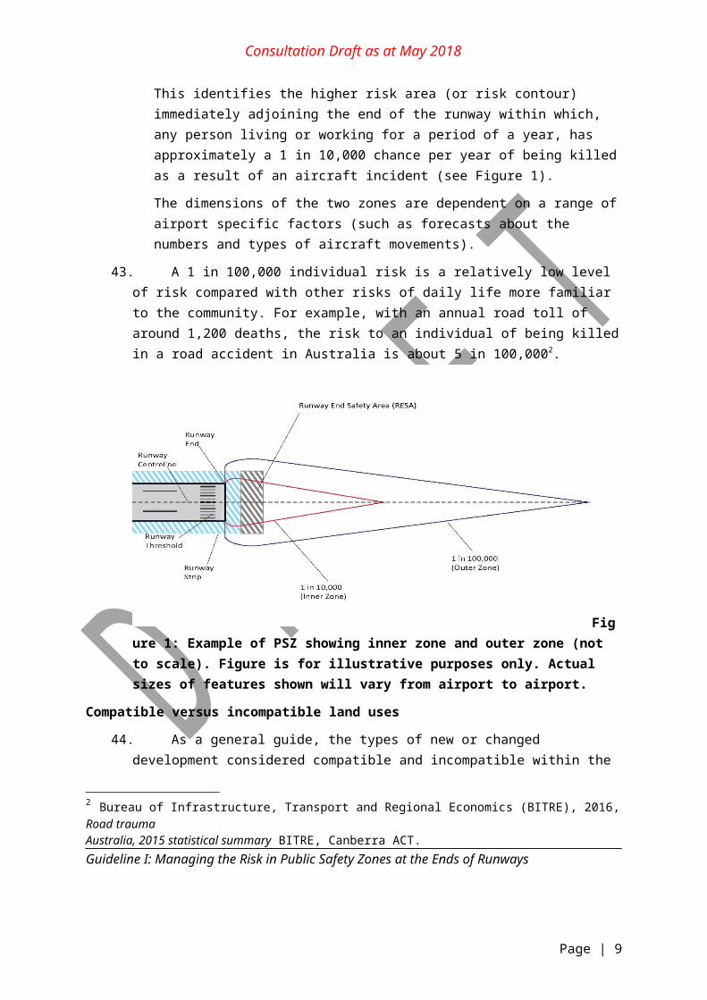
24. In some cases, the resultant shape of the PSZ is that of an elongated isosceles triangle (see Figure 1). In others, the triangle has been truncated to form an elongated four-sided shape (see Figure 2 in Attachment 2). In all cases, the PSZs are based on the landing threshold for each end of the runway and taper away from the runway centreline.
Guideline I: Managing the Risk in Public Safety Zones at the Ends of Runways
Page | 3
Consultation Draft as at May 2018
How the Guideline may be used
25. This Guideline provides guidance on planning-led and development-led approaches for the application of a PSZ planning framework (discussed further in paragraphs 51-59) in Australian jurisdictions.
26. As discussed in paragraph 11, there is no current ICAO standard for PSZs nor is a single risk methodology recognised as the world’s best practice.
27. Implementation of PSZs varies internationally and is not uniform. Some overseas jurisdictions have taken a specialised approach to the assessment and treatment of land use conflicts near airport runway ends and different models have been applied in the United Kingdom (UK), the Netherlands and the United States of America.
28. Within Australia, Queensland already has in place a proactive state planning policy and guidelines addressing public safety risks. Consequently, this document may provide guidance for their review and for policy updates. For those jurisdictions without existing policies, this Guideline may provide an objective basis for a policy response through strategic and statutory planning processes.
29. It is not intended that this Guideline will be applied retrospectively to existing development rather, it is intended to ensure there is no increase in risk from new development. New or replacement development, changes of use of existing buildings and rezoning of land are discouraged except if it results in reducing the number of people living, working or congregating within the PSZ. This Guideline can be used to inform strategic planning decisions about rezoning, development of greenfield sites and the opportunities for redevelopment of existing sites and urban infill.
30. There is a need to treat future development and existing development differently. Where there is no major existing or approved development, there is the opportunity to plan ahead to take account of potential public safety risk and, in particular, to minimise the zoning of land for incompatible land uses. Examples of incompatible uses within a PSZ contour are outlined in Table 1.
31. This Guideline applies to land both on and off-airport.
Managing risk within a PSZ
Public interest versus risk
32. Full implementation of PSZs in already developed areas requires a long term policy commitment and consideration should be given to the appropriate nature of further development in PSZs and balancing this with the public interest. It is recognised that most state and territory governments have targets or policies that need to be met, for example, to support regional economic growth.
Guideline I: Managing the Risk in Public Safety Zones at the Ends of Runways
Page | 4
Consultation Draft as at May 2018
33. This Guideline acknowledges that the risk from an aviation incident is only one element of an overall public safety risk assessment that jurisdictions may be considering as part of their planning processes. Other types of PSZs are implemented in Australia for the protection of the public from the risk created by a nearby site or activity, or the protection of the site itself. Commonwealth and state examples of legislation, regulation and planning documents that prescribe buffer zones and non-aviation PSZs include those for the nuclear research facility in Lucas Heights, NSW and the protection of World Heritage sites.
34. When considering general approaches to public safety risk, the ‘As Low As Reasonably Practicable’ (ALARP) approach, which was developed by the UK Health and Safety Executive, is commonly used. In particular, the NSW Department of Planning has previously adopted this method of addressing societal concerns when there is a risk of multiple fatalities occurring in one event as detailed in the document Hazardous Industry Planning Advisory Paper No.4 Risk Criteria for Land Use Safety Planning (January 2011).
35. The ALARP approach balances risk and societal benefit. Above a certain level a risk is regarded as intolerable and is forbidden irrespective of the potential benefit of a given project. The middle region is called the ALARP or Tolerability region, where risk is accepted if a benefit from continuing activities at that risk level exists. The bottom region exists where there is no need for detailed work to demonstrate ALARP, as it is the broadly acceptable region of negligible risk.
36. While there is no single agreed tolerable risk level defined in Australia or internationally, values in the range of 1 in a million to 1 in 10,000 are routinely adopted by various jurisdictions dependent on a range of circumstances.
37. At around the 1 in a million mark, the levels of individual risk begin to merge into the background risks from everyday life. Therefore, the range from 1 in a million to 1 in 10,000 per year is generally termed the ALARP region, within which risks should be ‘as low as reasonably practicable’.
PSZ risk contours
38. By considering PSZ risk, planning authorities can identify, consider and address the extent of statistical risk to people’s lives when located in proximity to runway ends, and undertake future planning appropriately.
39. The broad approach to the implementation of PSZ policy at an airport runway is based on modelling carried out using appropriate aircraft data to determine the level of risk to people on the ground around airports. This determines the extent of individual risk contours, upon which a person remaining in the same location for a period of a year would be subjected to a particular level of risk of being killed as a result of an aircraft accident.
40. Noting that no single best practice model for estimating risk contours has been identified in Australia or internationally, different risk assessment models can be used to identify zones of differing dimensions. Each approach has its own strengths and weaknesses and it is a
Guideline I: Managing the Risk in Public Safety Zones at the Ends of Runways
Page | 5
Consultation Draft as at May 2018
matter for individual jurisdictions or approval bodies to confirm the acceptable level of risk in the context of broader planning policies.
41. Two examples of most relevance to Australia (the UK and Queensland approaches) to developing PSZ contours are presented in Attachments 1 and 2. The UK model is the most formalised approach to defining a PSZ and has been applied at a number of international and Australian airports. The Queensland model is a modified version of the policy and research conducted in the UK.
42. Consistent with the UK approach to PSZs, this Guideline suggests a balanced approach with the PSZ made up of two different zones:
Outer zone = 1 in 100,000 (1 x 10⁻⁵) risk level per year
This identifies the area (or risk contour) within which, any person living or working for a period of a year, has approximately a 1 in 100,000 chance per year of being killed as a result of an aircraft incident (see Figure 1).
Inner zone = 1 in 10,000 (1 x 10⁻⁴) risk level per year
This identifies the higher risk area (or risk contour) immediately adjoining the end of the runway within which, any person living or working for a period of a year, has approximately a 1 in 10,000 chance per year of being killed as a result of an aircraft incident (see Figure 1).
The dimensions of the two zones are dependent on a range of airport specific factors (such as forecasts about the numbers and types of aircraft movements).
43. A 1 in 100,000 individual risk is a relatively low level of risk compared with other risks of daily life more familiar to the community. For example, with an annual road toll of around 1,200 deaths, the risk to an individual of being killed in a road accident in Australia is about 5 in 100,0002.
2 Bureau of Infrastructure, Transport and Regional Economics (BITRE), 2016, Road traumaAustralia, 2015 statistical summary BITRE, Canberra ACT.Guideline I: Managing the Risk in Public Safety Zones at the Ends of Runways
Page | 6
Consultation Draft as at May 2018
Figure 1: Example of PSZ showing inner zone and outer zone (not to scale). Figure is for illustrative purposes only. Actual sizes of features shown will vary from airport to airport.
Compatible versus incompatible land uses
44. As a general guide, the types of new or changed development considered compatible and incompatible within the outer (1 in 100,000) and inner (1 in 10,000) zones include those listed in Table 1.
45. Within the outer zone of a PSZ there are potential safety benefits from preventing any new or replacement development, or change of land use, which would result in an increase:
in the numbers of people living, working or congregating; or
the storage of hazardous materials.
46. There are stronger land use constraints for the inner zone. The general principle in relation to buildings and land within this zone is that people should not be expected to live or have their workplaces within such areas. Consequently, very few uses are considered potentially compatible within this risk contour.
47. Building and site uses which propose incompatible uses within the inner and outer zones (as listed in Table 1) should be actively discouraged. However, extensions to existing dwellings could be considered, as could development which involves a very low density of people.
48. Potentially incompatible land uses could be considered for approval in a PSZ if a satisfactory safety case, prepared by a suitably qualified technical expert, is provided. The approval body could consider imposing conditions to development consent for this type of development and restricting further intensification of the land use without a further safety case being assessed.
Guideline I: Managing the Risk in Public Safety Zones at the Ends of Runways
Page | 7

Consultation Draft as at May 2018
Transport Infrastructure
49. The planning of new transport infrastructure within PSZs should also be carefully considered. While a particular section of transport infrastructure is generally used by individuals for only a short period of time, a large number of people may be using the transport link at any given time. The density of occupation of a main road or railway line averaged over a day is comparable to that of residential development. For this reason, transport links within the PSZ should be assessed in terms of the average density of people that might be exposed to the risk.
50. Low intensity transport infrastructure such as minor or local roads could be considered acceptable within PSZs. Emergency vehicle access should be considered when planning transport infrastructure in and around a PSZ.
Guideline I: Managing the Risk in Public Safety Zones at the Ends of Runways
Page | 8
Consultation Draft as at May 2018
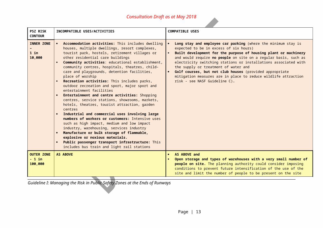
Table 1: General guidance for new/proposed developments on compatible and incompatible activities within PSZ risk contours
PSZ RISK CONTOUR
INCOMPATIBLE USES/ACTIVITIES COMPATIBLE USES
INNER ZONE – 1 in 10,000
Accommodation activities: This includes dwelling houses, multiple dwellings, resort complexes, tourist park, hostels, retirement villages or other residential care buildings
Community activities: educational establishment, community centres, hospitals, theatres, child-care and playgrounds, detention facilities, place of worship
Recreation activities: This includes parks, outdoor recreation and sport, major sport and entertainment facilities
Entertainment and centre activities: Shopping centres, service stations, showrooms, markets, hotels, theatres, tourist attraction, garden centres
Industrial and commercial uses involving large numbers of workers or customers: Intensive uses such as high impact, medium and low impact industry, warehousing, services industry
Manufacture or bulk storage of flammable, explosive or noxious materials.
Public passenger transport infrastructure: This includes bus train and light rail stations
Long stay and employee car parking (where the minimum stay is expected to be in excess of six hours)
Built development for the purpose of housing plant or machinery and would require no people on site on a regular basis, such as electricity switching stations or installations associated with the supply or treatment of water and
Golf courses, but not club houses (provided appropriate mitigation measures are in place to reduce wildlife attraction risk - see NASF Guideline C).
OUTER ZONE - 1 in 100,000
AS ABOVE AS ABOVE and Open storage and types of warehouses with a very small number of people on site. The
planning authority could consider imposing conditions to prevent future intensification of the use of the site and limit the number of people to be present on the site
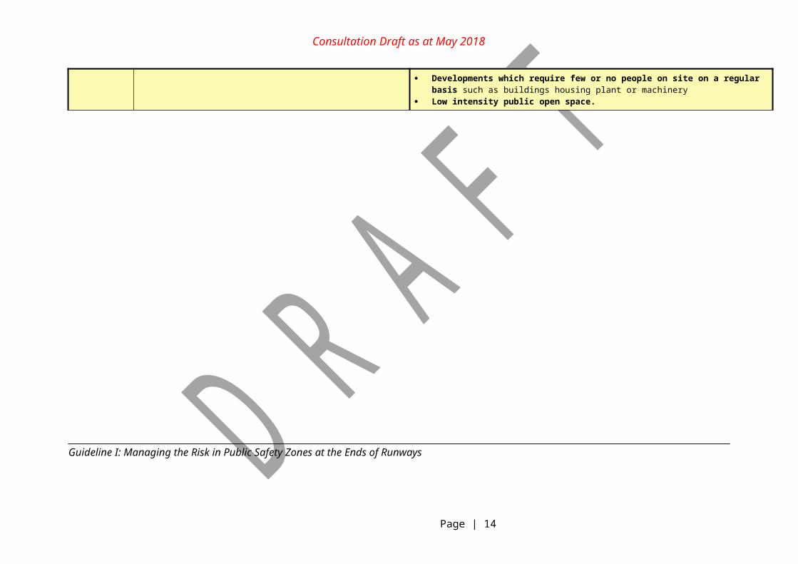
Developments which require few or no people on site on a regular basis such as buildings housing plant or machinery
Low intensity public open space.
Guideline I: Managing the Risk in Public Safety Zones at the Ends of Runways
Page | 9
Consultation Draft as at May 2018
Incorporating PSZ into planning processes
51. Approval bodies are encouraged to consider the potential public safety risk in the vicinity of airport runways as a component of the development assessment process, taking into account the nature of the development and the balance of public interest in terms of an objective analysis of the costs and benefits.
52. There is more than one acceptable approach to assessing the public safety risk in the vicinity of airports. To provide flexibility and cater for potential sensitivities associated with PSZs as well as to enable the consideration of other site specific characteristics and hazards, this Guideline recommends incorporating PSZ policies and modelling into the broader planning process through either a:
planning-led/proactive approach (e.g. UK and Qld models); or
development-led/reactive assessment process.
53. Individual jurisdictions or approval bodies may wish to draw on elements from both approaches.
Planning-led approach
54. A PSZ planning-led approach involves the proactive identification of a PSZ adjacent to an airport’s runway ends, within which certain development is restricted on the basis of unacceptable risk to public safety from an aircraft incident. This approach is applied when a planning authority amends their planning system to incorporate either:
individual runway specific PSZ contours (for the inner and outer zone) using the UK NATS methodology3 outlined in Attachment 1; or
an appropriate PSZ template as discussed in Attachment 2.
55. Both of the above options require supporting planning provisions to be reflected in the local planning instrument and draw upon the general guidance for new/proposed developments on compatible and incompatible activities within PSZ risk contours from Table 1.
Development-led approach
56. A PSZ development-led approach involves a reactive assessment process within a planning framework whereby public risk is assessed on a case-by-case basis where development is proposed within one kilometre of an airport runway end, or within an identified public safety assessment area.
57. Once a public risk has been identified as falling within one kilometre of an airport runway end, an assessment would be required to ascertain the level of risk to public safety by either:
3 NATS R&D Report 9636 Third Party Risk Near Airports and Public Safety Zone Policy was released in 1997 and there have been updates to the model relating to the model parameters and underlying crash data since that time.Guideline I: Managing the Risk in Public Safety Zones at the Ends of Runways
Page | 10
Consultation Draft as at May 2018
a) calculating the level of risk at all reference points in the proposed site using UK NATS methodology (outlined in Attachment 1); or
b) determining individual runway specific PSZ contours for the 1 in 10,000 and 1 in 100,000 contours using the UK NATS methodology (Attachment 1), or using an appropriate PSZ template (Attachment 2).
58. Following the above process, the approval body could then draw upon the compatible/incompatible land use framework from Table 1.
59. An example of a development-led approach is the South Australian Department of Planning, Transport and Infrastructure’s response to a rezoning proposal initiated by the City of Salisbury in June 2013. The proposal was for a $180 million entertainment and leisure development within one kilometre from the end of the runway at Parafield Airport. In this instance, the South Australian Minister for Planning required the Council to consider the fact that the proposed development potentially fell within a PSZ. The City of Salisbury engaged an expert consultant to undertake a safety analysis to ascertain the level of risk to public safety to inform Council’s decision.
Military Public Safety Zones
60. Defence is responsible for providing public safety advice in relation to military aerodromes. Military aircraft, although different in operational tempo, face the same risks in take-off and landing as civilian aircraft. The risk to people on the ground from a military aircraft accident is very low, however such an incident can, by its nature, have serious consequences in terms of the range and extent of its impact. Councils should maintain low density land uses along flight paths close to military runways by ensuring that development is assessed in terms of its compatibility with minimising public safety risk.
61. The UK PSZ model is based on civil fixed wing aircraft and is not suited to the operation of military aircraft. Military aircraft incidents differ from commercial air carrier and general aviation incidents because of the variety of aircraft used, the type of missions and the number of training flights. Due to the serious consequences associated with aircraft incidents, Defence seeks to address this safety issue from a land use planning perspective.
62. The only existing military public safety model that Defence is aware of is the United States Department of Defense (US DoD) Accident Prevention Zones (APZ) model. The US DoD model was specifically designed for military aircraft and was based on actual military crash data. A review of historic Australian military aircraft crash data found similar trends to that of US modelling.
63. Until Defence has developed its own military PSZs, it is recommended that state and local government planning authorities refer to the US DoD model for guidance when planning for future land uses along the extended centre line of military airfields. Defence is not seeking to have military PSZs apply retrospectively to existing urban development. Details on the US DoD model are provided in Attachment 3.
Guideline I: Managing the Risk in Public Safety Zones at the Ends of Runways
Page | 11
Consultation Draft as at May 2018
ATTACHMENT 1
UK PSZ Aviation Model
1. The administration of UK PSZ policy is carried out by the UK Civil Aviation Authority. The UK PSZ policy is outlined in Department for Transport (DfT) Circular 01/20104. The UK methodology is based on the principles set out in a study conducted by the Research and Development Directorate of NATS (formerly National Air Traffic Services Limited) on behalf of the DfT. The study is described fully in NATS R&D Report 9636 Third Party Risk Near Airports and Public Safety Zone Policy (NATS, London, June 1997)5.
2. This methodology assesses the risk of an individual fatality in the vicinity of an airport as a result of an aircraft crash during landing or take-off determines potential crash locations in relation to a runway’s extended centreline. Using this approach, NATS has calculated the individual runway specific PSZ contours for more than 35 UK Airports.
3. The UK work is based on modelling carried out using aircraft accident data to determine the level of risk to people on the ground around airports. The modelling determines the extent of individual risk contours upon which a person remaining in the same location for a year would be subjected to a particular level of risk of being killed as a result of an aircraft accident. The UK PSZ policy is based predominantly on individual risk, while extending it to consider particular types of development such as transport infrastructure and to temporary uses. The UK model maps the area that applies an individual risk calculation to 1 in 10,000 and 1 in 100,000 risk contours for that airport.
4. The areas of the PSZ correspond essentially to the 1 in 100,000 individual risk contours as calculated for each airport, based on forecasts about the numbers and types of aircraft movements fifteen years ahead.
5. The individual risk profile of an airport is determined by:
the statistical expectation that an aircraft crash occurs in the vicinity of the airport; the probability, given a crash has occurred, that it affects a particular location; the size of the area likely to be affected as a result of a crash; and the probability of fatality for people on the ground within that area.
6. The UK policy for restricting new development within PSZs uses a constrained cost-benefit analysis (CBA) to determine specific land use restrictions. The CBA quantifies the benefits from reducing risk and compares these with the costs of removing or prohibiting activities at each point from outside the 1 in 10,000 contour to the edge of the 1 in 100,000 contour.
7. The UK model recommends that the PSZ risk contours around airports be remodelled at intervals of about seven years.
4 UK Department for Transport Circular 1/2010 Control of Development in Airport Public Safety Zones.5 This report was released in 1997 and there have been updates to the model relating to the model parameters and underlying crash data since that time.Guideline I: Managing the Risk in Public Safety Zones at the Ends of Runways
Page | 12
Consultation Draft as at May 2018
ATTACHMENT 2EXAMPLES OF PSZ TEMPLATES
Queensland State Planning Policy (SPP) - Public Safety Area (PSA) Model
1. In Australia, Queensland has had a planning framework covering PSZs (known as public safety areas (PSAs)) since 1992. The 2017 State Planning Policy for PSA’s and risk methodology, which is a modified version of research conducted in the UK on risk to third parties, is currently under review by the Queensland Government. The review is considering the suitability of moving to a more tailored airport-specific approach based on the UK methodology.
2. Other Australian jurisdictions and the Australian Government (see Western Sydney Airport discussed below in paragraphs 8-10) have referenced the Queensland policy approach when assessing public safety cases for development near airports.
3. The Queensland PSA model, established by the Queensland State Planning Policy (SPP), applies a single defined PSA template to all runways that meet certain criteria in terms of aircraft movements. The dimensions of the Queensland PSZ template were determined with reference to the UK methodology for determining third party risk.
4. A PSA forms the shape of an isosceles trapezoid—1000 metres long, 350 metres wide closest to the runway end, tapering to a width of 250 metres furthest from the runway (see Figure 2). It lies beneath the approach or take-off path where the aircraft is closest to the ground at the end of the runway.
Figure 2: Queensland Public Safety Area
Guideline I: Managing the Risk in Public Safety Zones at the Ends of Runways
Page | 13
Consultation Draft as at May 2018
5. Queensland policy is that development within PSAs should not increase the risk to public safety from an aircraft accident near the ends of airport runways. Therefore, the following should be avoided:
increases in the numbers of people living, working or congregating in the public safety areas; or
the use of noxious or hazardous materials.
6. Existing development commitments within PSAs are allowed to remain. However, the scale of risk to the public should be reduced by appropriate conditions on future development approvals (e.g. a condition preventing the storage of hazardous materials in an industrial development). Some reduction in public risk by modifying current development uses might be achieved through negotiation with owners and developers.
7. An assessment of a development’s compatibility with PSAs has to consider:
the direct impacts to people in the aircraft and on ground; and
the secondary incidents arising from damage to ground facilities, such as storage facilities for explosive, flammable or other hazardous materials.
Western Sydney Airport
8. An example of the Australian Government’s approach to PSZs can be illustrated by the Western Sydney Airport where, in line with the Queensland PSZ template approach and in the absence of a national standard, both the Airport Plan and Environmental Impact Statement nominally identify a 1,000m trapezoid-shaped clearance zone, extending off the ends of each proposed runway to cover the area of highest safety risk. This approach will be reviewed closer to construction of the new airport commencing.
9. The PSZs have been identified in these early planning stages of the proposed new airport in order to encourage land use planning and development that does not pose a public safety risk and is compatible with the future development of the airport.
10. Where the PSZs are identified for the Western Sydney Airport, additional scrutiny might be considered for new developments that:
increase residential use and population density in the zone; attract large numbers of people, such as retail or entertainment developments; involve institutional uses, such as schools and hospitals; involve the manufacture or depot storage of noxious and hazardous materials; and attract significant static traffic.
Guideline I: Managing the Risk in Public Safety Zones at the Ends of Runways
Page | 14
Consultation Draft as at May 2018
ATTACHMENT 3
EXAMPLE OF MILITARY PSZ: UNITED STATES OF AMERICA DEPARTMENT OF DEFENSE ACCIDENT POTENTIAL ZONES
Background
1. The Accident Potential Zone (APZ) Guidelines were developed as a standard for public safety areas and quickly adopted by US Department of Defense to ensure the health, safety and welfare of those living near a military airport whilst sustaining airfield operations.
2. The US Department of Defense runways are split into two (2) types:
Class A Runways are usually 2438.4 metres long and are used primarily by light aircraft and do not have the potential for intensive use by heavy or high performance aircraft.
Class B Runways are all other fixed-wing runways.
3. These runways have defined public safety areas with three dedicated zones, as shown on Figure 3.
Figure 3: Adapted from US Department of Defense Accident Potential Zones. Source: Office of Economic Adjustment, Practical Guide to Compatible Civilian Development Near Military Installations, July 2005.
Guideline I: Managing the Risk in Public Safety Zones at the Ends of Runways
Page | 15
Consultation Draft as at May 2018
4. These APZs are areas where an aircraft accident is likely to occur, but they do not reflect the probability of an accident. APZs follow arrival, departure and pattern flight tracks and are based upon analysis of historical accident data.
5. The Air Installations Compatible Use Zones maps define three APZs – the Clear Zone, APZ 1 and APZ 2. The Clear Zone extends 914 metres beyond the runway and has the highest potential for accidents. APZ 1 extends 1524 metres beyond the Clear Zone, and APZ 2 extends 2134 metres beyond APZ 1.
6. If an accident were to occur, it is more likely to occur in APZ 1 than APZ 2, and more likely to occur in the Clear Zone than either APZ 1 or APZ 2.
7. As stated above, APZs follow arrival, departure, and pattern flight tracks. However, APZs are not ‘roadways’ in the sky. Weather conditions, wind, pilot technique, and other air traffic will typically cause some lateral deviation within the landing pattern around an airfield.
8. Under the US DoD Model certain land uses are not considered compatible with military flying operations. Within the clear zone (CZ), there should be no structures of any kind. Agriculture is the recommended land use, with the exception that there should not be horticultural activities.
9. Land uses applicable to the APZ 1 and APZ 2 areas are included at Annex A. Generally, development that encourages large congregations of people or involves the storage or handling of significant quantities of hazardous materials is prohibited (e.g. residential, shopping centres, places of assembly, hotels), while uses permitted tend to included structures that do not encourage permanent settlement or large congregations of people (e.g. bulk manufacturing and warehouses).
Implementation
10. The Australian Department of Defence is seeking to work collaboratively with state, territory and local governments to adapt the above US DoD Model for military airfields within their planning jurisdiction. As previously noted Defence is not seeking to have an adapted military PSZ model apply retrospectively to existing development or remove existing development rights, but rather the adapted model should be used to inform future land use planning decisions in areas along the extended centre line of military airfields.
11. State and local government planning authorities should at a minimum consider applying the Clear Zone and APZ 1 zone. State, territory and local government planning authorities would need to consider the US Model land use compatibility tables (see Annex A), in consultation with Defence, in relation to their own land use definition schedules.
Guideline I: Managing the Risk in Public Safety Zones at the Ends of Runways
Page | 16
Consultation Draft as at May 2018
Annex A
Land Use Compatibility in Accident Potential Zones (Extract from USA Air Force Instruction AFI 32-7063 dated 18 December 2015).
Guideline I: Managing the Risk in Public Safety Zones at the Ends of Runways
Page | 17
Consultation Draft as at May 2018
Guideline I: Managing the Risk in Public Safety Zones at the Ends of Runways
Page | 18