Embed Size (px)
Citation preview
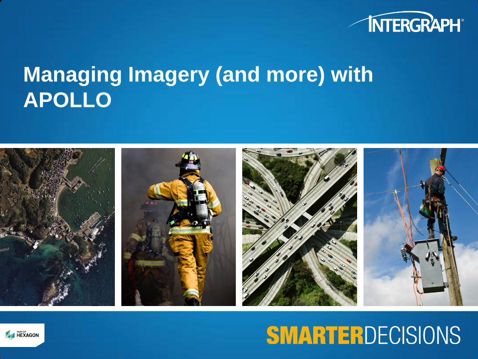
Managing Imagery (and more) with
APOLLO
Market Needs
• Need to leverage huge amounts of geospatial information (GI)
• Amount of data – collected and derived – increasing exponentially
• Data integrated and used in visualization, analysis, decision help, etc.
• Dynamic discovery of dispersed information
• Find data you need, when you need it
• From public, private subscription sources
• Need for quicker access & response time to market demand
• Implying a real-time access to data
• Custom front-ends on personalized and specialized services
• For vertical market applications
• Examples:
Discover and purchase data
Search locations
Real-time portrayal of data
Coordinate transformations
Creating value added products on-demand (i.e. server-side geoprocessing)
What is APOLLO?
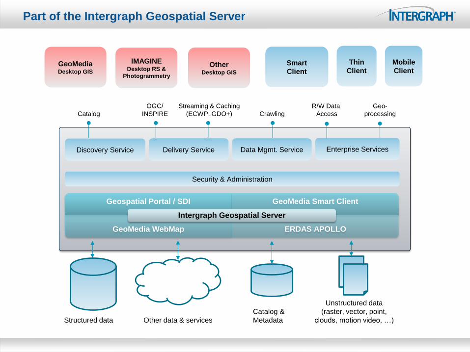
Discovery Service Data Mgmt. Service Delivery Service Enterprise Services
OGC/
INSPIRE
Streaming & Caching
(ECWP, GDO+) Catalog Crawling
R/W Data
Access
Geo-
processing
Catalog &
Metadata Structured data
Unstructured data
(raster, vector, point,
clouds, motion video, …) Other data & services
GeoMedia Desktop GIS
Smart
Client
Thin
Client
Mobile
Client
Security & Administration
Geospatial Portal / SDI GeoMedia Smart Client
GeoMedia WebMap ERDAS APOLLO
Intergraph Geospatial Server
Part of the Intergraph Geospatial Server
IMAGINE Desktop RS &
Photogrammetry
Other Desktop GIS
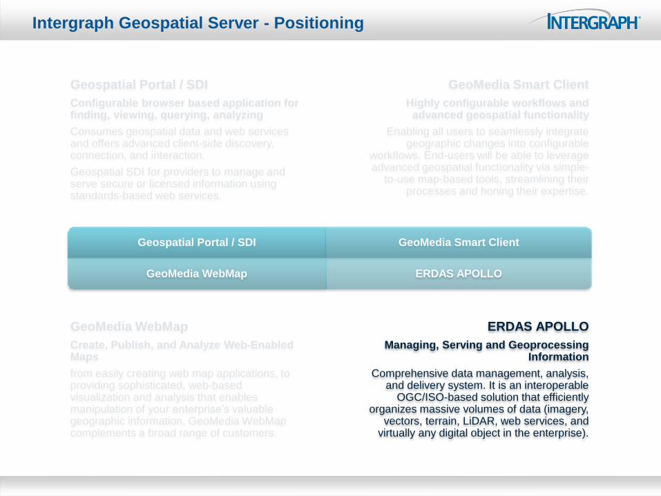
Geospatial Portal / SDI GeoMedia Smart Client
GeoMedia WebMap ERDAS APOLLO
Intergraph Geospatial Server - Positioning
Geospatial Portal / SDI
Configurable browser based application for finding, viewing, querying, analyzing
Consumes geospatial data and web services and offers advanced client-side discovery, connection, and interaction.
Geospatial SDI for providers to manage and serve secure or licensed information using standards-based web services.
GeoMedia Smart Client
Highly configurable workflows and advanced geospatial functionality
Enabling all users to seamlessly integrate geographic changes into configurable
workflows. End-users will be able to leverage advanced geospatial functionality via simple-
to-use map-based tools, streamlining their processes and honing their expertise.
GeoMedia WebMap
Create, Publish, and Analyze Web-Enabled Maps
from easily creating web map applications, to providing sophisticated, web-based visualization and analysis that enables manipulation of your enterprise’s valuable geographic information, GeoMedia WebMap complements a broad range of customers.
ERDAS APOLLO
Managing, Serving and Geoprocessing Information
Comprehensive data management, analysis, and delivery system. It is an interoperable
OGC/ISO-based solution that efficiently organizes massive volumes of data (imagery,
vectors, terrain, LiDAR, web services, and virtually any digital object in the enterprise).
Standards Support and Promote Integration
Data
Discovery Map
Projections
Data
Styling
Sensor
Models MetaData
Queries
Spatial
Models
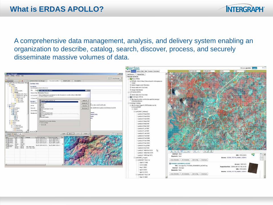
What is ERDAS APOLLO?
A comprehensive data management, analysis, and delivery system enabling an
organization to describe, catalog, search, discover, process, and securely
disseminate massive volumes of data.
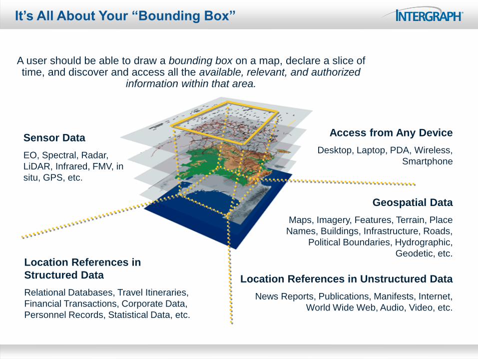
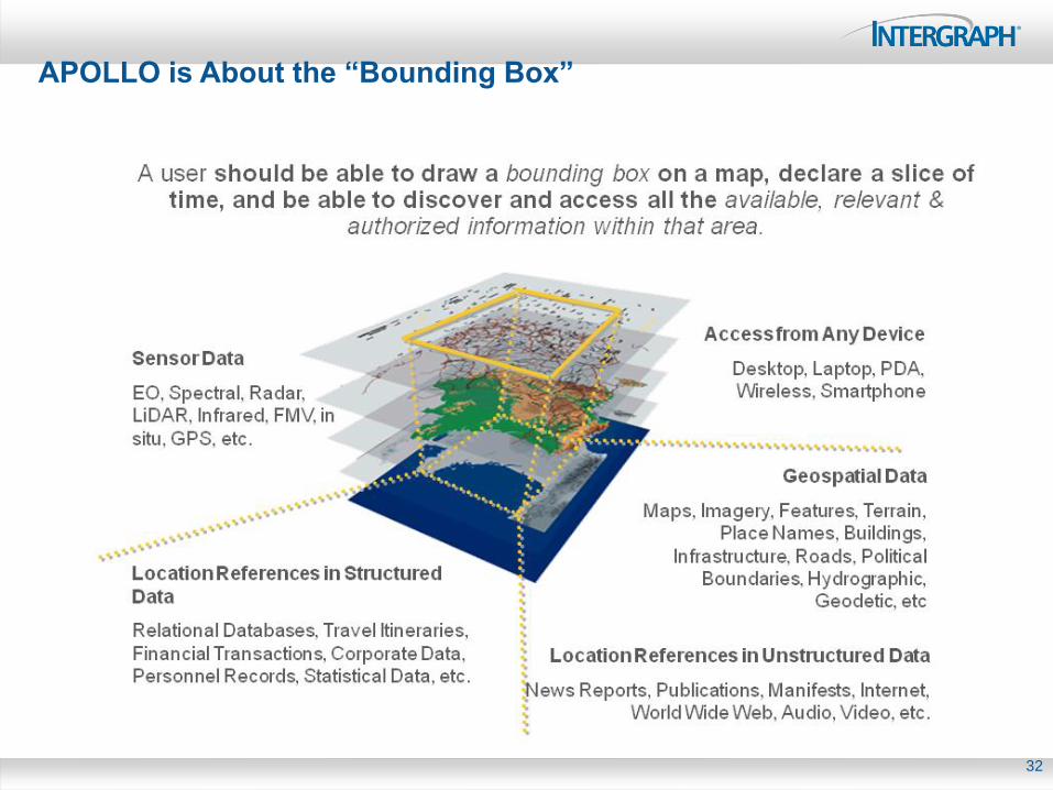
It’s All About Your “Bounding Box”
A user should be able to draw a bounding box on a map, declare a slice of time, and discover and access all the available, relevant, and authorized
information within that area.
Geospatial Data
Maps, Imagery, Features, Terrain, Place
Names, Buildings, Infrastructure, Roads,
Political Boundaries, Hydrographic,
Geodetic, etc. Location References in
Structured Data
Relational Databases, Travel Itineraries,
Financial Transactions, Corporate Data,
Personnel Records, Statistical Data, etc.
Sensor Data
EO, Spectral, Radar,
LiDAR, Infrared, FMV, in
situ, GPS, etc.
Access from Any Device
Desktop, Laptop, PDA, Wireless,
Smartphone
Location References in Unstructured Data
News Reports, Publications, Manifests, Internet,
World Wide Web, Audio, Video, etc.
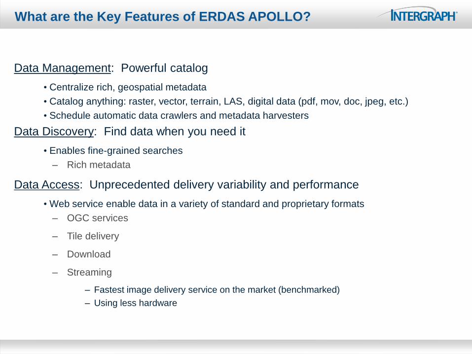
What are the Key Features of ERDAS APOLLO?
Data Management: Powerful catalog
• Centralize rich, geospatial metadata
• Catalog anything: raster, vector, terrain, LAS, digital data (pdf, mov, doc, jpeg, etc.)
• Schedule automatic data crawlers and metadata harvesters
Data Discovery: Find data when you need it
• Enables fine-grained searches
– Rich metadata
Data Access: Unprecedented delivery variability and performance
• Web service enable data in a variety of standard and proprietary formats
– OGC services
– Tile delivery
– Download
– Streaming
– Fastest image delivery service on the market (benchmarked)
– Using less hardware
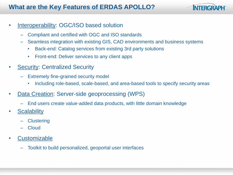
• Interoperability: OGC/ISO based solution
– Compliant and certified with OGC and ISO standards
– Seamless integration with existing GIS, CAD environments and business systems
• Back-end: Catalog services from existing 3rd party solutions
• Front-end: Deliver services to any client apps
• Security: Centralized Security
– Extremely fine-grained security model
• Including role-based, scale-based, and area-based tools to specify security areas
• Data Creation: Server-side geoprocessing (WPS)
– End users create value-added data products, with little domain knowledge
• Scalability
– Clustering
– Cloud
• Customizable
– Toolkit to build personalized, geoportal user interfaces
What are the Key Features of ERDAS APOLLO?
Feature Data
(Arc, SDO, FME)
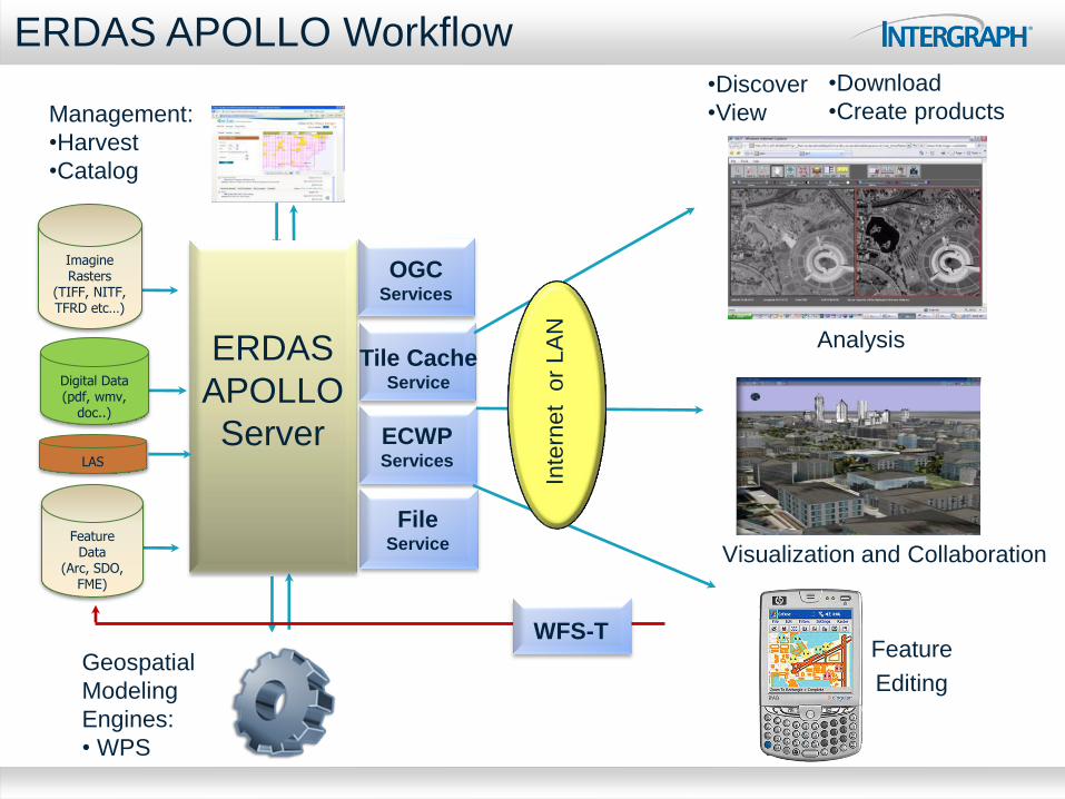
ERDAS APOLLO Workflow
Analysis
Feature
Editing Geospatial
Modeling
Engines:
• WPS
Management:
•Harvest
•Catalog
ERDAS
APOLLO
Server
Tile Cache Service
ECWP Services
Inte
rne
t o
r L
AN
OGC Services
Imagine Rasters
(TIFF, NITF, TFRD etc…)
Visualization and Collaboration
Digital Data (pdf, wmv,
doc..)
File Service
LAS
WFS-T
•Discover
•View
•Download
•Create products
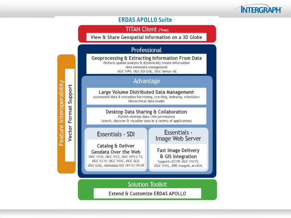
ERDAS APOLLO Essentials - SDI
• Entry-level SDI
• For getting static data on the Internet
• Web service enabled
– Vectors, terrain, raster data
– Support OGC/ISO WMS, WCS, WFS, GML, CS-W, SLD
– Harvest metadata from service and layer descriptions
• Catalog Anything Electronic
– Documents, blueprints, models, IMAGINE Template Files, pictures, web
URLs … anything electronic or URL accessible
• Remote Data Manager rich client platform
– Manage the server from your desktop
• Out-of-the-box Web Client
ERDAS APOLLO Essentials - IWS
• Fastest geospatial imagery server in the world, period
• Deliver terabytes of image data to thousands of people
•ECWP high-speed streaming imagery
•5,000 users simultaneously
•Optimized Tile Delivery (OTDF) - Fast tile-based delivery of tiled data
•4000+ tiles a second
•10,000 users simultaneously
• Into various GIS, CAD, mobile, web or other desktop software)
• Supports common industry standards for deployment
• Easily integrates data from existing GIS
• Highly cost-effective
•Requires only standard server hardware
ERDAS APOLLO Advantage
• For organizations with massive volumes of distributed, constantly
changing data holdings
• Requiring advanced, out-of-the-box:
– Security
– Data models
– Scheduling capabilities for AUTOMATIC metadata crawling and
harvesting
• Delivers raw data (download available)
• Clip, zip, and ship
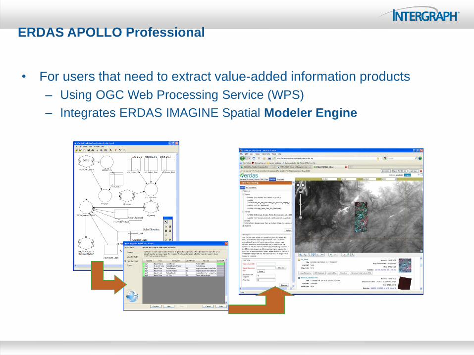
ERDAS APOLLO Professional
• For users that need to extract value-added information products
– Using OGC Web Processing Service (WPS)
– Integrates ERDAS IMAGINE Spatial Modeler Engine
ERDAS APOLLO Solution Toolkit
• Facilitates customization of ERDAS APOLLO to meet your specific
business use-case
– Extend existing APOLLO Web Client or create new ones
– Add support for new data or metadata formats
• Includes
– Web Toolkit: build customized end-user web interfaces
– Remote APIs: remotely access and consume services
– Connector APIs: extend ERDAS APOLLO data and metadata support
– Portrayal APIs: create custom styling rules
– Extensive documentation
– Quick Start Projects
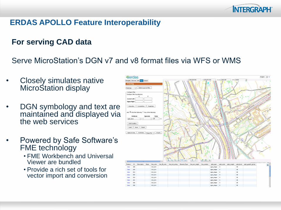
• Closely simulates native MicroStation display
• DGN symbology and text are maintained and displayed via the web services
• Powered by Safe Software’s FME technology
• FME Workbench and Universal Viewer are bundled
• Provide a rich set of tools for vector import and conversion
ERDAS APOLLO Feature Interoperability
For serving CAD data
Serve MicroStation’s DGN v7 and v8 format files via WFS or WMS
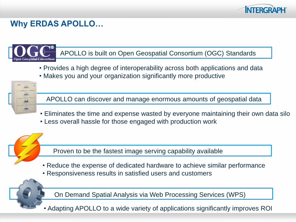
Why ERDAS APOLLO…
APOLLO is built on Open Geospatial Consortium (OGC) Standards
• Provides a high degree of interoperability across both applications and data
• Makes you and your organization significantly more productive
Proven to be the fastest image serving capability available
• Reduce the expense of dedicated hardware to achieve similar performance
• Responsiveness results in satisfied users and customers
APOLLO can discover and manage enormous amounts of geospatial data
• Eliminates the time and expense wasted by everyone maintaining their own data silo
• Less overall hassle for those engaged with production work
On Demand Spatial Analysis via Web Processing Services (WPS)
• Adapting APOLLO to a wide variety of applications significantly improves ROI
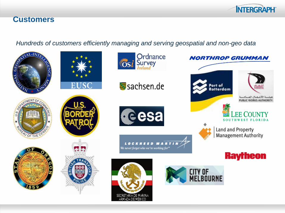
Customers
Hundreds of customers efficiently managing and serving geospatial and non-geo data
Managing LiDAR
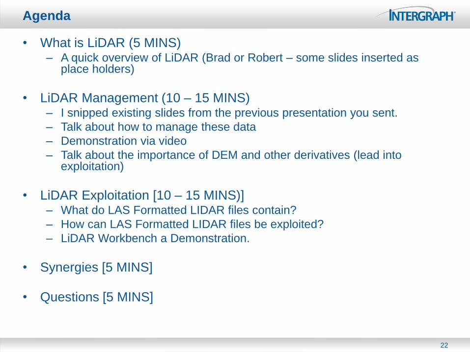
Agenda
• What is LiDAR (5 MINS) – A quick overview of LiDAR (Brad or Robert – some slides inserted as
place holders)
• LiDAR Management (10 – 15 MINS) – I snipped existing slides from the previous presentation you sent.
– Talk about how to manage these data
– Demonstration via video
– Talk about the importance of DEM and other derivatives (lead into exploitation)
• LiDAR Exploitation [10 – 15 MINS)] – What do LAS Formatted LIDAR files contain?
– How can LAS Formatted LIDAR files be exploited?
– LiDAR Workbench a Demonstration.
• Synergies [5 MINS]
• Questions [5 MINS]
22
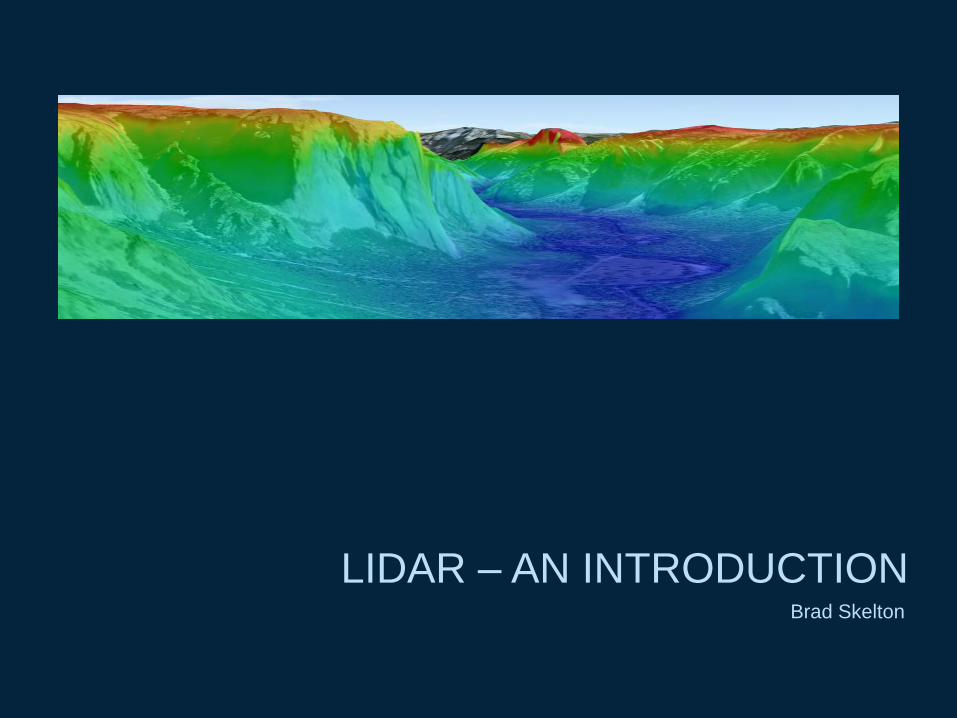
LIDAR – AN INTRODUCTION Brad Skelton
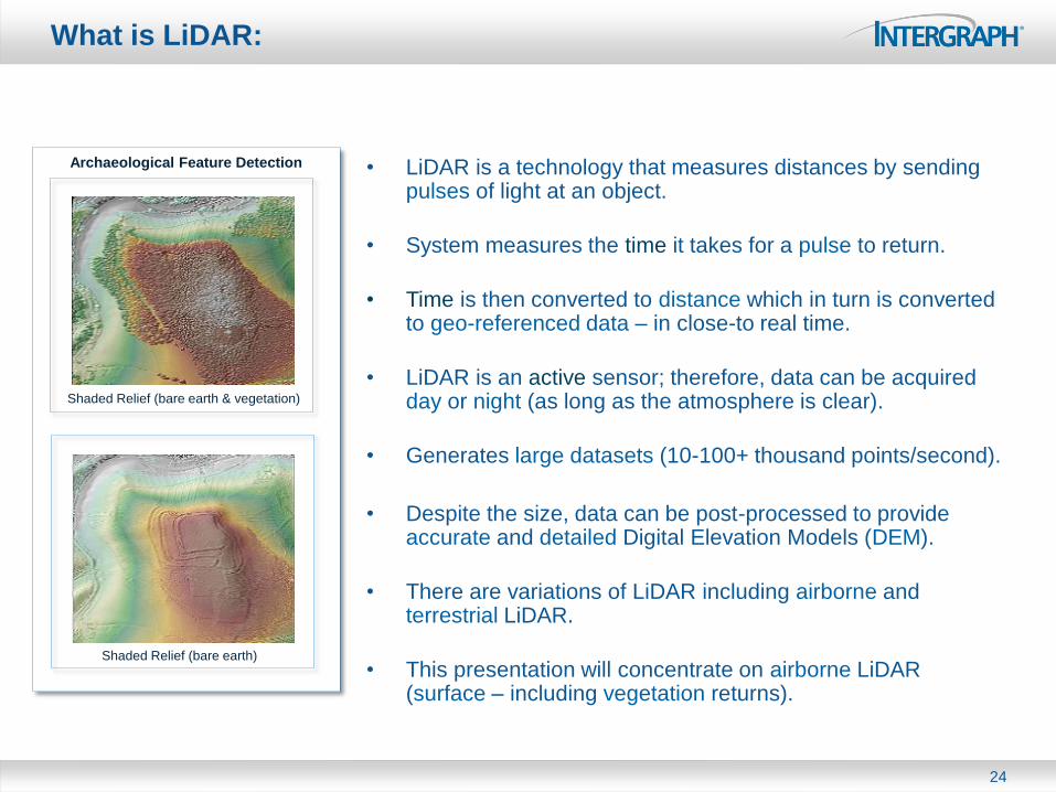
What is LiDAR:
• LiDAR is a technology that measures distances by sending pulses of light at an object.
• System measures the time it takes for a pulse to return.
• Time is then converted to distance which in turn is converted to geo-referenced data – in close-to real time.
• LiDAR is an active sensor; therefore, data can be acquired day or night (as long as the atmosphere is clear).
• Generates large datasets (10-100+ thousand points/second).
• Despite the size, data can be post-processed to provide accurate and detailed Digital Elevation Models (DEM).
• There are variations of LiDAR including airborne and terrestrial LiDAR.
• This presentation will concentrate on airborne LiDAR (surface – including vegetation returns).
24
Shaded Relief (bare earth & vegetation)
Shaded Relief (bare earth)
Archaeological Feature Detection

How Does LiDAR Work
• LiDAR sends thousands of laser pulses to the ground every second. The pulses are directed from the aircraft using an oscillating mirror.
• This results in a dense set of data points arranged in a swath buffering the plane's flight line.
• The LiDAR distance measurements are converted to map coordinates and elevations.
• Note: Multiple returns are possible, thereby allowing mapping of bare earth vegetation, buildings, etc.
–
• After each mission, the data are downloaded and post processed.
• Data are commonly distributed as ASPRS* LAS files.
25
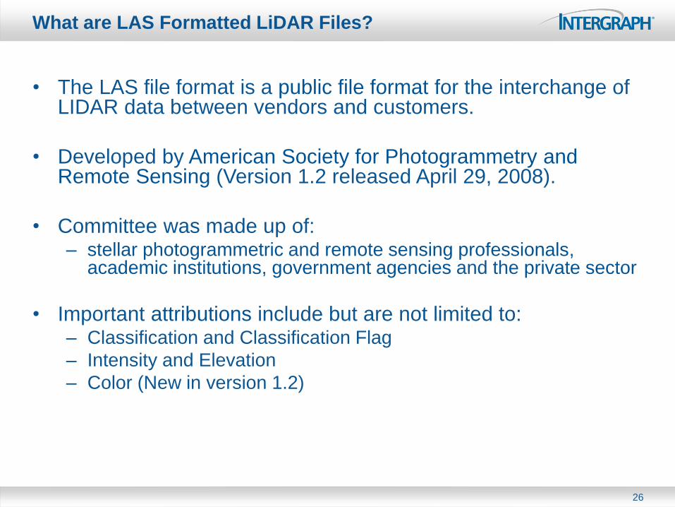
What are LAS Formatted LiDAR Files?
• The LAS file format is a public file format for the interchange of LIDAR data between vendors and customers.
• Developed by American Society for Photogrammetry and Remote Sensing (Version 1.2 released April 29, 2008).
• Committee was made up of: – stellar photogrammetric and remote sensing professionals,
academic institutions, government agencies and the private sector
• Important attributions include but are not limited to: – Classification and Classification Flag
– Intensity and Elevation
– Color (New in version 1.2)
26
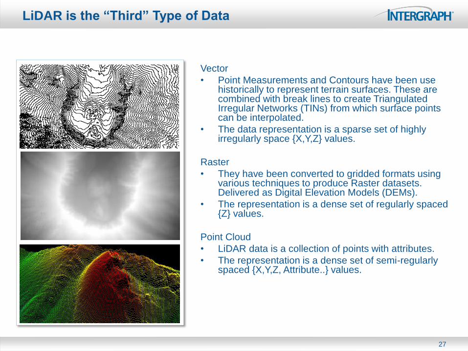
LiDAR is the “Third” Type of Data
Vector
• Point Measurements and Contours have been use historically to represent terrain surfaces. These are combined with break lines to create Triangulated Irregular Networks (TINs) from which surface points can be interpolated.
• The data representation is a sparse set of highly irregularly space {X,Y,Z} values.
Raster
• They have been converted to gridded formats using various techniques to produce Raster datasets. Delivered as Digital Elevation Models (DEMs).
• The representation is a dense set of regularly spaced {Z} values.
Point Cloud
• LiDAR data is a collection of points with attributes.
• The representation is a dense set of semi-regularly spaced {X,Y,Z, Attribute..} values.
27

MANAGING LIDAR Brad Skelton - ERDAS
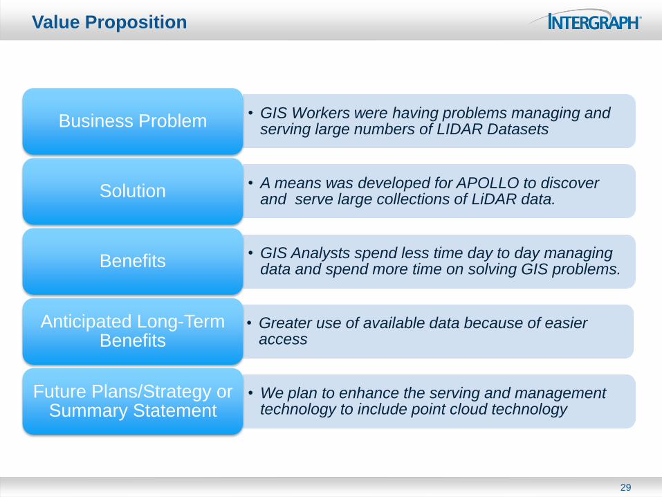
Value Proposition
• GIS Workers were having problems managing and serving large numbers of LIDAR Datasets Business Problem
• A means was developed for APOLLO to discover and serve large collections of LiDAR data. Solution
• GIS Analysts spend less time day to day managing data and spend more time on solving GIS problems. Benefits
• Greater use of available data because of easier access
Anticipated Long-Term Benefits
• We plan to enhance the serving and management technology to include point cloud technology
Future Plans/Strategy or Summary Statement
29
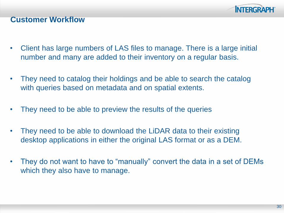
Customer Workflow
• Client has large numbers of LAS files to manage. There is a large initial
number and many are added to their inventory on a regular basis.
• They need to catalog their holdings and be able to search the catalog
with queries based on metadata and on spatial extents.
• They need to be able to preview the results of the queries
• They need to be able to download the LiDAR data to their existing
desktop applications in either the original LAS format or as a DEM.
• They do not want to have to “manually” convert the data in a set of DEMs
which they also have to manage.
30
ERDAS APOLLO Data Management
31
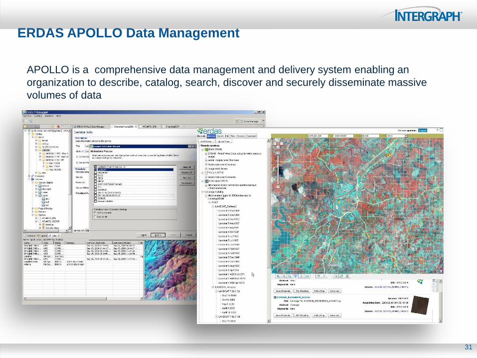
APOLLO is a comprehensive data management and delivery system enabling an
organization to describe, catalog, search, discover and securely disseminate massive
volumes of data
APOLLO is About the “Bounding Box”
32
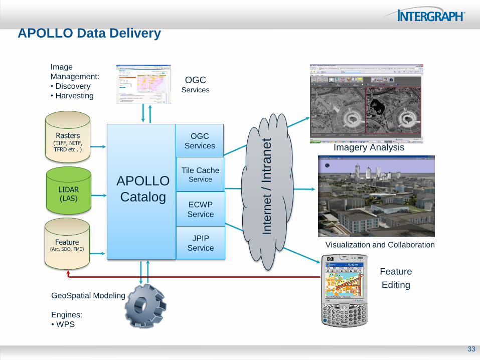
APOLLO Data Delivery
33
Feature (Arc, SDO, FME)
Imagery Analysis
Feature
Editing GeoSpatial Modeling
Engines:
• WPS
Image
Management:
• Discovery
• Harvesting
APOLLO
Catalog
Inte
rnet / In
tra
ne
t OGC
Services
OGC Services
Rasters (TIFF, NITF, TFRD etc…)
Visualization and Collaboration
LIDAR (LAS)
Tile Cache Service
ECWP
Service
JPIP
Service
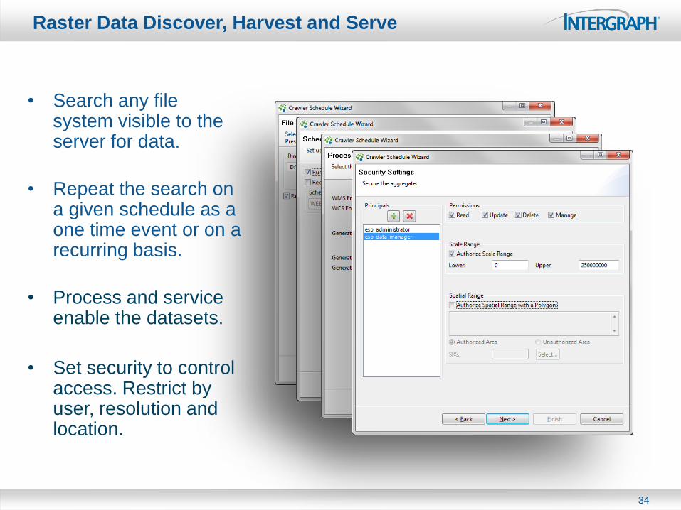
Raster Data Discover, Harvest and Serve
34
• Search any file system visible to the server for data.
• Repeat the search on a given schedule as a one time event or on a recurring basis.
• Process and service enable the datasets.
• Set security to control access. Restrict by user, resolution and location.
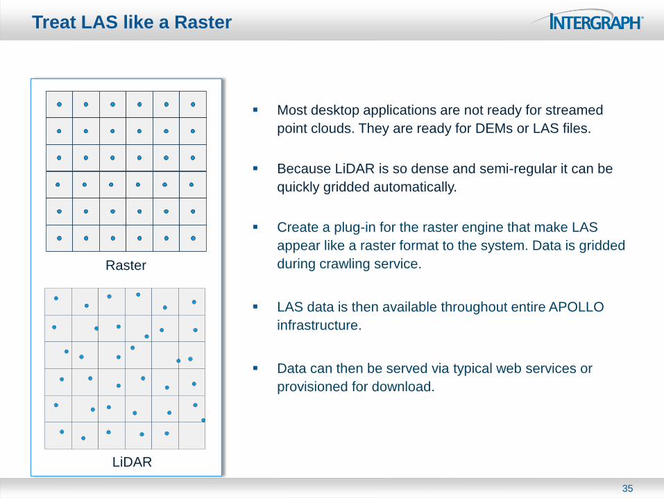
Treat LAS like a Raster
35
Most desktop applications are not ready for streamed
point clouds. They are ready for DEMs or LAS files.
Because LiDAR is so dense and semi-regular it can be
quickly gridded automatically.
Create a plug-in for the raster engine that make LAS
appear like a raster format to the system. Data is gridded
during crawling service.
LAS data is then available throughout entire APOLLO
infrastructure.
Data can then be served via typical web services or
provisioned for download.
Raster
LiDAR

LiDAR Data in the APOLLO Web Client
36
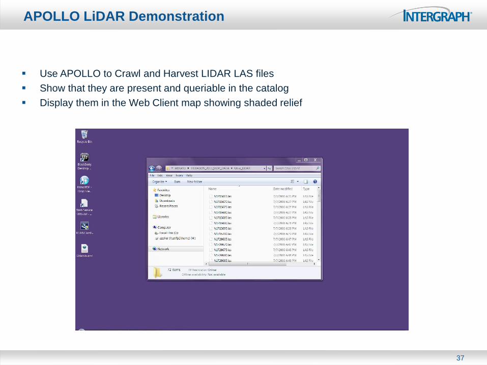
APOLLO LiDAR Demonstration
37
Use APOLLO to Crawl and Harvest LIDAR LAS files
Show that they are present and queriable in the catalog
Display them in the Web Client map showing shaded relief
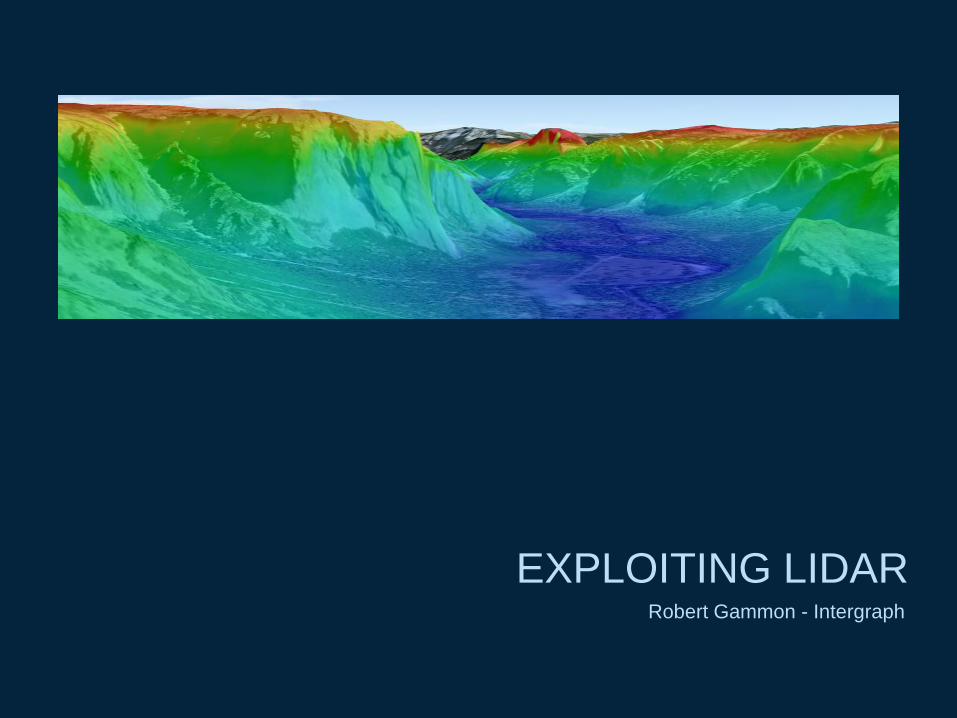
EXPLOITING LIDAR Robert Gammon - Intergraph
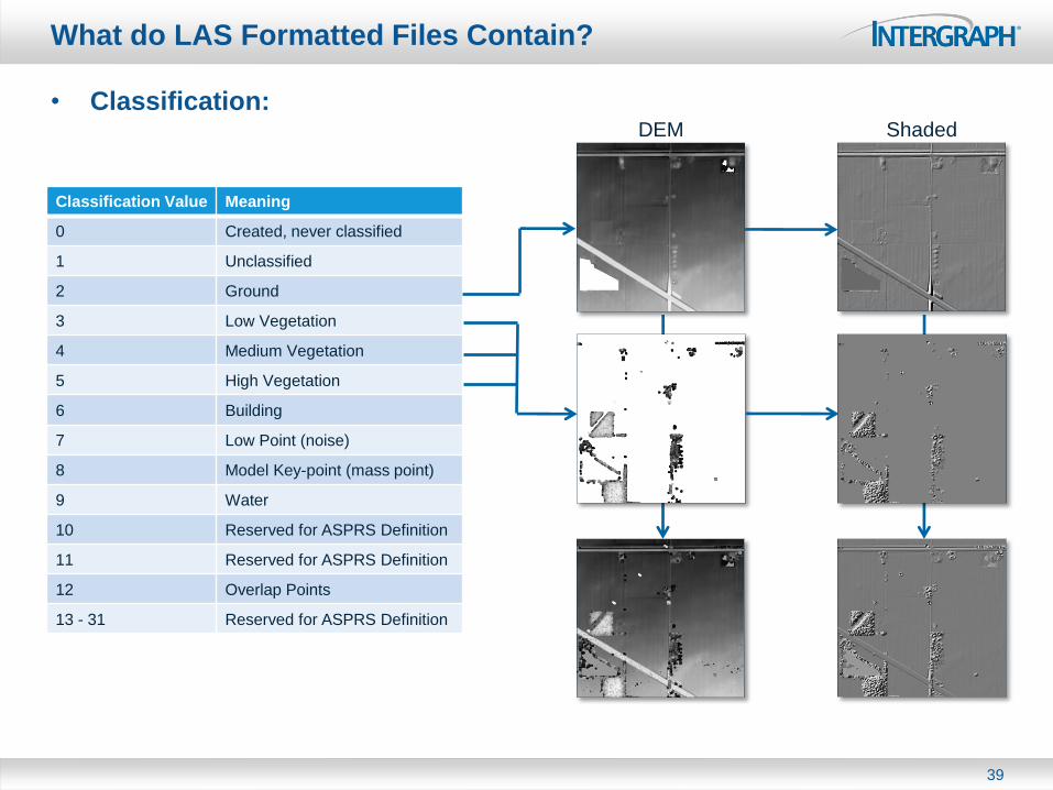
What do LAS Formatted Files Contain?
• Classification:
39
Classification Value Meaning
0 Created, never classified
1 Unclassified
2 Ground
3 Low Vegetation
4 Medium Vegetation
5 High Vegetation
6 Building
7 Low Point (noise)
8 Model Key-point (mass point)
9 Water
10 Reserved for ASPRS Definition
11 Reserved for ASPRS Definition
12 Overlap Points
13 - 31 Reserved for ASPRS Definition
DEM Shaded
What do LAS Formatted Files Contain?
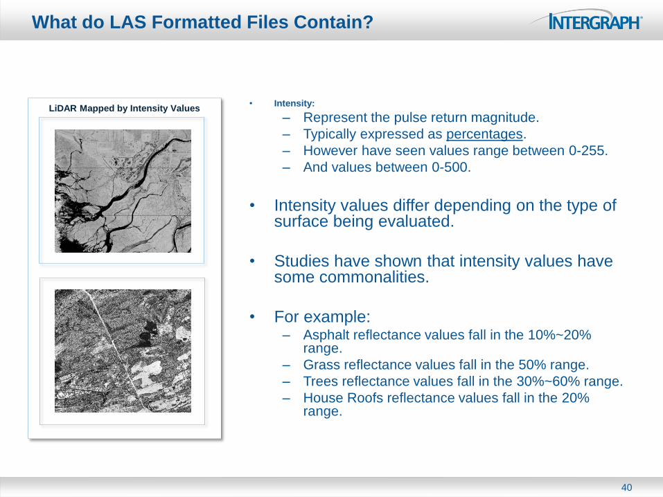
• Intensity:
– Represent the pulse return magnitude.
– Typically expressed as percentages.
– However have seen values range between 0-255.
– And values between 0-500.
• Intensity values differ depending on the type of surface being evaluated.
• Studies have shown that intensity values have some commonalities.
• For example: – Asphalt reflectance values fall in the 10%~20%
range.
– Grass reflectance values fall in the 50% range.
– Trees reflectance values fall in the 30%~60% range.
– House Roofs reflectance values fall in the 20% range.
40
LiDAR Mapped by Intensity Values
What do LAS Formatted Files Contain?
• Elevation:
– Contains the Z value for the point
– Commonly expressed in meters
– Usually expressed in with 2 levels of precision
(centimetres)
• Color:
– Data dependent (introduced as part of version
1.2)
– Contains the red, green, and blue color
channels as a long integer
– Represents a color for each point
41
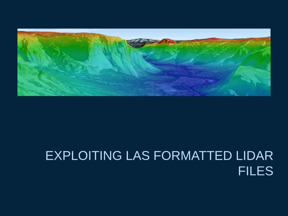
EXPLOITING LAS FORMATTED LIDAR
FILES
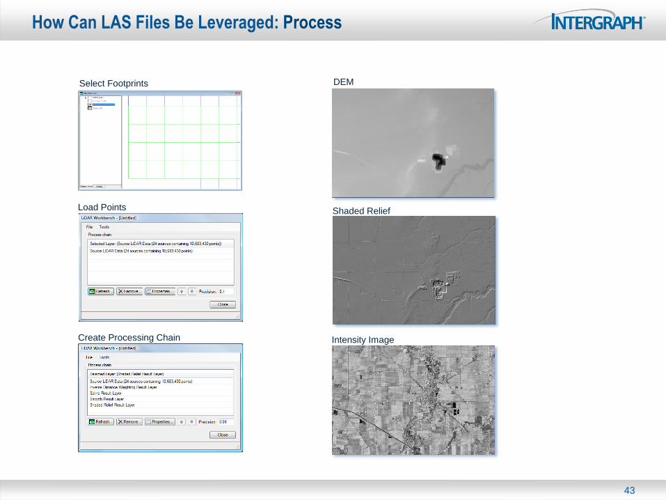
How Can LAS Files Be Leveraged: Process
43
Select Footprints
Load Points
Create Processing Chain
DEM
Shaded Relief
Intensity Image
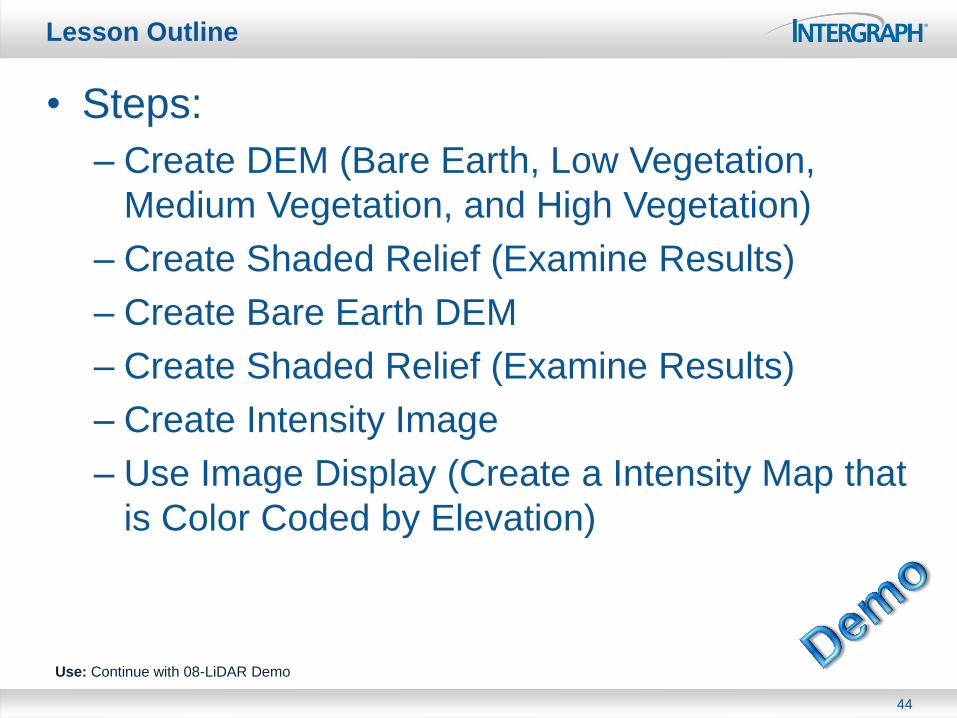
Lesson Outline
• Steps:
– Create DEM (Bare Earth, Low Vegetation,
Medium Vegetation, and High Vegetation)
– Create Shaded Relief (Examine Results)
– Create Bare Earth DEM
– Create Shaded Relief (Examine Results)
– Create Intensity Image
– Use Image Display (Create a Intensity Map that
is Color Coded by Elevation)
44
Use: Continue with 08-LiDAR Demo

Exploiting LAS Formatted Files: Surface Analytics
45
Slope (Gradient) Aspect Contours
Shaded Relief Hydrological Modeling Viewshed Analysis
Complete DEM
Volume (Cut & Fill) Curvature Others...
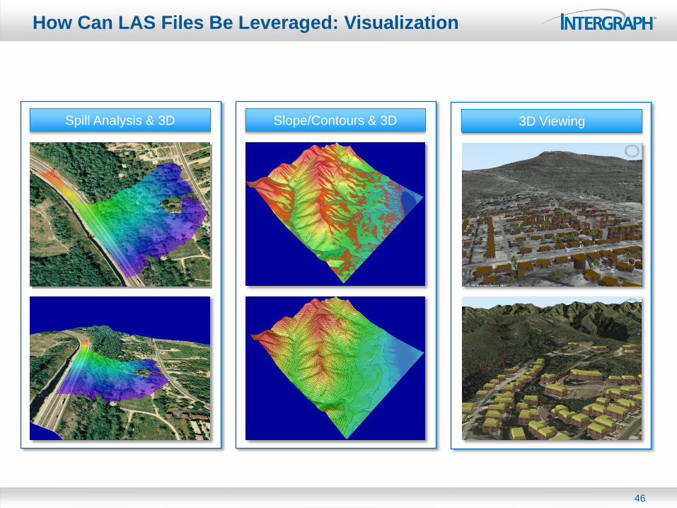
How Can LAS Files Be Leveraged: Visualization
46
Spill Analysis & 3D Slope/Contours & 3D 3D Viewing
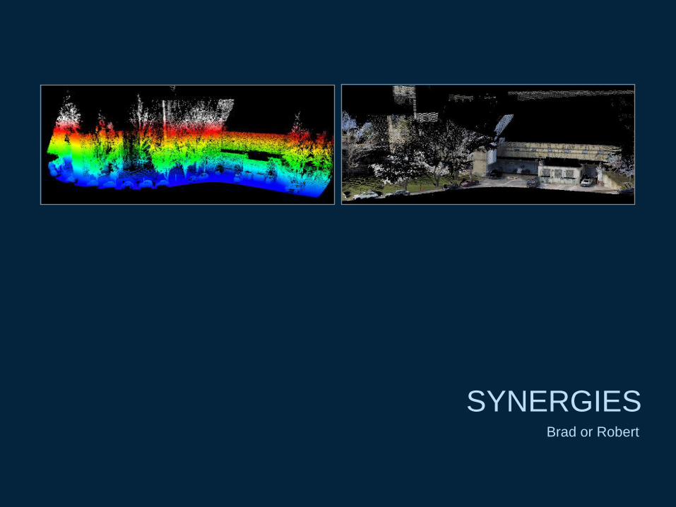
SYNERGIES Brad or Robert
Visualize point data as raster surfaces using Apollo from ERDAS and GeoMedia Grid from Intergraph Corporation.
Visualize point data as a cloud using CloudWorx and the Cyclone Point Cloud Engine Suite from Leica Geosystems.
Visualize point data using a TIN representation using Leica Terrain Format the Terrain Editor within LPS from ERDAS.
Synergies
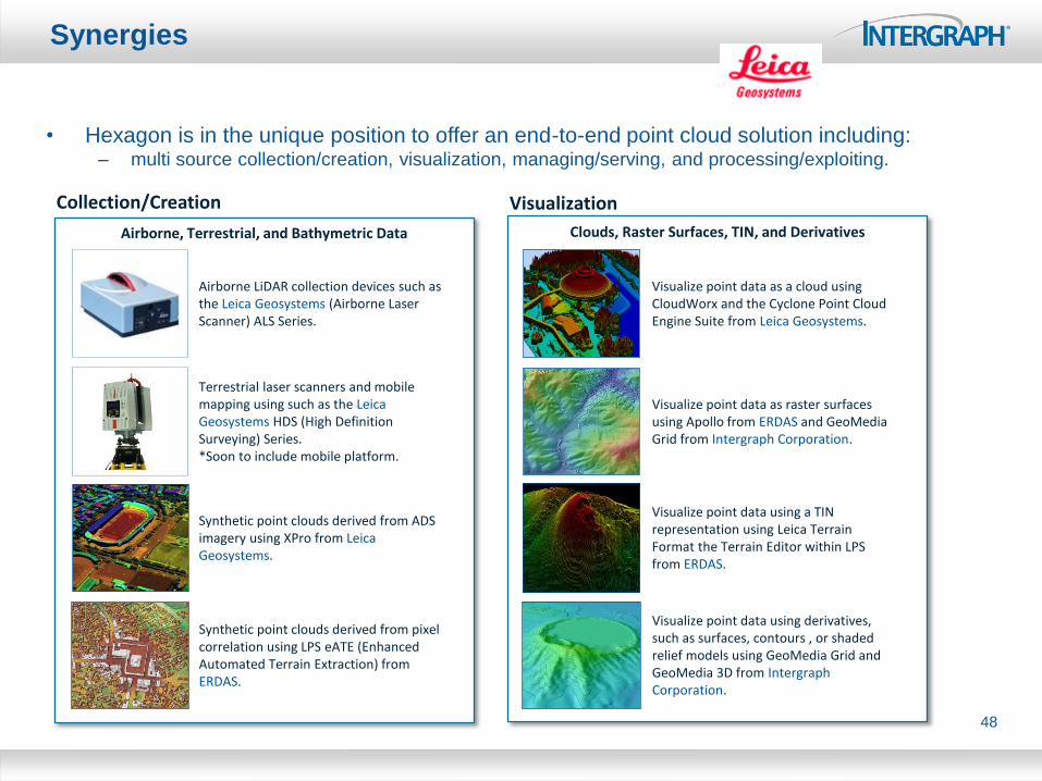
• Hexagon is in the unique position to offer an end-to-end point cloud solution including: – multi source collection/creation, visualization, managing/serving, and processing/exploiting.
48
Collection/Creation
Airborne, Terrestrial, and Bathymetric Data
Terrestrial laser scanners and mobile mapping using such as the Leica Geosystems HDS (High Definition Surveying) Series. *Soon to include mobile platform.
Airborne LiDAR collection devices such as the Leica Geosystems (Airborne Laser Scanner) ALS Series.
Synthetic point clouds derived from ADS imagery using XPro from Leica Geosystems.
Visualization
Clouds, Raster Surfaces, TIN, and Derivatives
Visualize point data using derivatives, such as surfaces, contours , or shaded relief models using GeoMedia Grid and GeoMedia 3D from Intergraph Corporation.
Synthetic point clouds derived from pixel correlation using LPS eATE (Enhanced Automated Terrain Extraction) from ERDAS.
Synergies
49
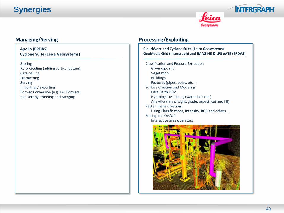
Managing/Serving Processing/Exploiting
CloudWorx and Cyclone Suite (Leica Geosystems) GeoMedia Grid (Intergraph) and IMAGINE & LPS eATE (ERDAS)
Apollo (ERDAS) Cyclone Suite (Leica Geosystems)
Storing Re-projecting (adding vertical datum) Cataloguing Discovering Serving Importing / Exporting Format Conversion (e.g. LAS Formats) Sub-setting, thinning and Merging
Classification and Feature Extraction Ground points Vegetation Buildings Features (pipes, poles, etc…) Surface Creation and Modeling Bare Earth DEM Hydrologic Modeling (watershed etc.) Analytics (line of sight, grade, aspect, cut and fill) Raster Image Creation Using Classifications, Intensity, RGB and others… Editing and QA/QC Interactive area operators
Thank You