Embed Size (px)
Citation preview

Page 1 of 112
Management Plan #3 2016 to 2021

Page 2 of 112
Acknowledgements
The creation of this Research Forest was the result of the hard work and contribution of a forestry coalition that was led by the British Columbia Ministry of Forests, Lands and Natural Resource Operations and the forest Industry represented by the Council of Forest Industries. Members of the working group included the Association of British Columbia Forest Professionals, Canadian Forest Products Ltd., the Canadian Institute of Forestry, Central Interior Logging Association, Council on Northern Interior Forest Employment Relations, the Consulting Foresters of British Columbia, the Prince George Truckers Association, Spectrum Resources Group and the University of Northern British Columbia. CNC is also very appreciative of the collaboration and support of Dunkley Lumber Ltd., who is a critically important partner in the operational implementation of the Research Forest.
Without the foresight of these groups, there would not be a Research Forest committed to applied forestry research in central/northern British Columbia, nor would there be any form of technical forestry and natural resource education offered by the College of New Caledonia (CNC). Thanks to these efforts it will not only be possible to continue to provide technical education programming but to add another dimension to forest management research and education in the region.
With the focus on resource development of natural resources in the interior of British Columbia, it will be increasingly important to have skilled resource managers available to address the challenges ahead. They will require skills and knowledge enhanced by relevant applied research conducted in northern forest types. With assets like the CNC Research Forest and a community education focus, CNC will be able to contribute to meeting the needs of the resource sector in a significant way for some time to come.

Page 3 of 112
Introduction .................................................................................................................... 7
Current Management Challenges .................................................................................... 8
The Research Forest Structure ......................................................................................... 8
Legislative and Regulatory Framework ........................................................................................8
Role of the CNC Research Forest Society......................................................................................9
Role of College of New Caledonia ................................................................................................9
Vision for Research and Innovation within the CNC Research Forest.........................................10
Term and Scope ............................................................................................................ 12
Location and Geography ............................................................................................... 12
Natural Resource Management Objectives, Results, and Strategies ............................... 13
Varying from the Management Plan ..........................................................................................13
No Forest Stewardship Plan Required ........................................................................................14
Prince George Land and Resource Management Plan ................................................................14
Landscape Biodiversity and Old Forest Maintenance.................................................................14
Order Establishing Landscape Biodiversity Objectives for the Prince George Timber Supply Area (PGTSA)
.................................................................................................................................................................... 14
Old Forest Retention Objective .................................................................................................................. 14
Interior Old Forest Objective...................................................................................................................... 15
Young Forest Patch Size Distribution Objective ......................................................................................... 16
Species at Risk Conservation and Protection .............................................................................16
Wildlife Tree and Coarse Woody Debris Retention ....................................................................17
Wildlife Tree Retention .............................................................................................................................. 17
Coarse Woody Debris Retention ................................................................................................................ 18
Riparian Area and Water Quality Management .........................................................................19
Riparian Area Management ....................................................................................................................... 19
Water Quality Management ...................................................................................................................... 21
Watershed Management ...........................................................................................................21
Soil Management .......................................................................................................................24
Soil Disturbance from Permanent Roads ................................................................................................... 24
Dispersed Soil Disturbance ......................................................................................................................... 25
Visual Quality Management.......................................................................................................25
Recreation Management ...........................................................................................................26
Existing and New Recreation Use ............................................................................................................... 26
Provincial Parks, Protected Areas, and Ecological Reserves ...................................................................... 27
Provincial Recreation Sites and Trails......................................................................................................... 27
Road and Trail Access Management ..........................................................................................28
Research Site Locations..............................................................................................................28

Page 4 of 112
Provincial Designations and Forest/Land Tenures .....................................................................28
Tacheeda Lakes Ecological Reserve ............................................................................................................ 28
Sugarbowl-Grizzly Den Provincial Park and Protected Area ...................................................................... 29
Fraser River Provincial Park ........................................................................................................................ 29
Adjacent or Overlapping Provincial Resource Stakeholders.......................................................30
Tree Farm License 30 ................................................................................................................................. 30
Forestry License to Cut, Special Use Permit, Road Permit, and Road-use Permit Holders ........................ 30
Forest License Holders ............................................................................................................................... 30
Trapping, Guiding, and Range Tenures ...................................................................................................... 31
Mining Tenure and Notice of Work ............................................................................................................ 32
Other Land Tenures .................................................................................................................................... 32
Adjacent Land Owners ...............................................................................................................33
Archaeological and Cultural Heritage Resources ........................................................................33
Forest Health Management .......................................................................................................34
All Forest Health Factors ............................................................................................................................ 34
Mountain Pine Beetle Salvage ................................................................................................................... 35
Spruce Beetle Sanitation and Salvage ........................................................................................................ 35
Vegetation Management ...........................................................................................................36
Invasive Plants ............................................................................................................................................ 36
Deciduous and Brush Competition for Conifer Trees................................................................................. 36
Timber Growth and Yield Management .....................................................................................37
Managing Timber for Forest Products ....................................................................................................... 37
Non-Sawlog Wood Fibre ............................................................................................................................ 37
Natural Non-Productive Forest and Natural Non-commercial Cover ........................................................ 37
Problem Forest Types................................................................................................................................. 37
Regeneration of Forest, Use of Seed, and Free Growing Stands ............................................................... 37
Tree Seed.................................................................................................................................................... 38
Tree Species and Tree Density Selection.................................................................................................... 38
Tree Regeneration Delay ............................................................................................................................ 39
Tree Planting .............................................................................................................................................. 39
Silviculture Treatments .............................................................................................................................. 39
Allowable Annual Cut Analysis ...................................................................................... 39
Current Timber Supply Analysis and Modelling .........................................................................39
The Timber Harvesting Land Base Netdown ..............................................................................39
Yield Tables ................................................................................................................................40
Assumptions Applied in Analysis ...............................................................................................40
Timber Supply Sensitivity Scenarios...........................................................................................41
Resulting Allowable Annual Cut .................................................................................................42
Managing Allowable Annual Cut ................................................................................................43
First Nations' Territory .................................................................................................. 43
McLeod Lake Indian Band – Tse’Khene (Sekani) Territory..........................................................43

Page 5 of 112
West Moberly First Nations .......................................................................................................43
Halfway River First Nation .........................................................................................................43
Lheidli T’enneh First Nation .......................................................................................................43
Nazko First Nation .....................................................................................................................43
First Nations Information Sharing and Involvement ....................................................... 44
First Nations Involvement in the CNC Research Forest Society ..................................................44
First Nations Strategic Planning Involvement ............................................................................44
First Nations Consultation Regarding Management Plan ...........................................................44
Sharing and Involvement in Specific Resource Operations ........................................................44
First Nations Related Research and Innovation .........................................................................45
Public Input and Review ................................................................................................ 45
Notifying and Reporting to Government ........................................................................ 46
Requirement for Forest Professionals and Other Professionals ....................................... 46
Periodic Management Plan Review ............................................................................... 46
Development Plans and Site Plans ................................................................................. 46
Licensee Commitments .................................................................................................. 47
Appendix A: Research Forest Funding for the Natural Resources and Environmental
Technology Program ..................................................................................................... 49
Appendix B: Prince George Forest District Red and Blue Listed Ecological Communities
and Species ................................................................................................................... 50
Appendix C: Additional Riparian Management Requirements under the Forest Planning
and Practices Regulation ............................................................................................... 56
Appendix D: Preliminary Stream and Watershed Study ................................................. 57
Unit A – Weedon Creek and Kerry Lake-Crooked River Watersheds ......................................................... 57
Unit B – Tacheeda Lakes and Horseshoe Lake Watersheds ....................................................................... 57
Unit C – Caine Creek and Merton Creek Watersheds ................................................................................ 58
Unit D – Caine Creek Watershed ................................................................................................................ 58
Unit E – Chuchinka Creek Watershed ........................................................................................................ 59
Unit F – Chuchinka Creek and Angusmac Creek Watersheds .................................................................... 59
Unit G - Angusmac Creek and Crooked River Watershed .......................................................................... 60
Unit H – Bowron River Watershed ............................................................................................................. 60
Unit I – Hungary Creek and Fraser River Watersheds ................................................................................ 60
Unit J - Fraser River Watershed .................................................................................................................. 61
Appendix E: Visual Quality Objectives: Definition of altered forest landscape under The
Forest Planning and Practices Regulation ...................................................................... 68
Appendix F: Research Site Locations ............................................................................. 69

Page 6 of 112
Appendix G: Management Plan Content Map ............................................................... 83
Appendix H: Timber Supply Analysis and Review........................................................... 92
Page 7 of 112
Introduction
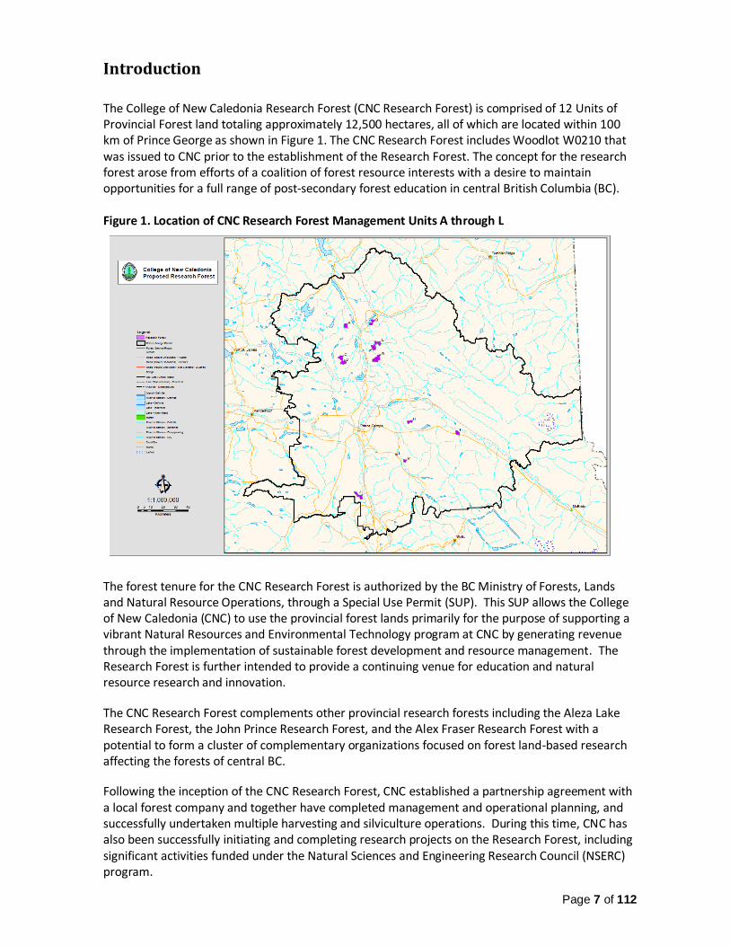
The College of New Caledonia Research Forest (CNC Research Forest) is comprised of 12 Units of Provincial Forest land totaling approximately 12,500 hectares, all of which are located within 100 km of Prince George as shown in Figure 1. The CNC Research Forest includes Woodlot W0210 that was issued to CNC prior to the establishment of the Research Forest. The concept for the research forest arose from efforts of a coalition of forest resource interests with a desire to maintain opportunities for a full range of post-secondary forest education in central British Columbia (BC). Figure 1. Location of CNC Research Forest Management Units A through L
The forest tenure for the CNC Research Forest is authorized by the BC Ministry of Forests, Lands and Natural Resource Operations, through a Special Use Permit (SUP). This SUP allows the College of New Caledonia (CNC) to use the provincial forest lands primarily for the purpose of supporting a vibrant Natural Resources and Environmental Technology program at CNC by generating revenue through the implementation of sustainable forest development and resource management. The Research Forest is further intended to provide a continuing venue for education and natural resource research and innovation.
The CNC Research Forest complements other provincial research forests including the Aleza Lake Research Forest, the John Prince Research Forest, and the Alex Fraser Research Forest with a potential to form a cluster of complementary organizations focused on forest land-based research affecting the forests of central BC.
Following the inception of the CNC Research Forest, CNC established a partnership agreement with a local forest company and together have completed management and operational planning, and successfully undertaken multiple harvesting and silviculture operations. During this time, CNC has also been successfully initiating and completing research projects on the Research Forest, including significant activities funded under the Natural Sciences and Engineering Research Council (NSERC) program.

Page 8 of 112
Current Management Challenges The CNC Research Forest is located within forested landscapes that are subject to a large variety of naturally occurring forest health factors including insects, pathogens, abiotic (such as fire), and wildlife damage. These perturbations to timber, ecosystem function, and wildlife habitat are cyclical and typically result from a combination of environmental factors (e.g., hot, dry summers) and historical resource management activities (e.g., fire exclusion). At low or endemic levels, these forest health factors are an integral component of ecosystem function, however in outbreak mode certain forest health factors may cause widespread and catastrophic damage. Such is the case with the current outbreak of spruce beetle that has rapidly expanded over the last two years within the northern portion of the Prince George Natural Resource District. Under the current favorable climatic conditions (e.g. droughty summers) and the wide distribution of susceptible spruce-leading stands, spruce beetle attack is expected to continue to expand. The widespread spruce beetle-caused mortality throughout the Parsnip River drainage to the east is rapidly advancing westward. To the north of Summit Lake there are now large areas of spruce beetle west of the Crooked River. The CNC Research Forest units north of Prince George are immediately adjacent or in the midst of very large spruce beetle populations. At the time of this plan, Research Forest Units C, D, E, F, and G were moderately to severely affected by spruce beetle. Only Unit B is at a low level of spruce beetle infestation. All of the remaining areas within Units B to G, and all of Unit A, remain under high threat of increased spruce beetle infestation. The magnitude of the current infestation and its predicted expansion has warranted a major revision to the Research Forest management plan. This will be accomplished through an update of the forest inventory, other natural resource values, and management practices. As a result, this new management plan will reflect notable revisions to timber management practices as well as substantial revisions to the management of other natural resources. There is considerable uncertainty involved in predicting future impacts of the spruce beetle infestation, but this management plan strives to minimize the uncertainty regarding the short-term (five-year) management of timber, forest health factors, and other natural resources within the Research Forest. Proactive detection and assessment of forest health, along with efficient forest health management and effective timber value recovery are all expected outcomes of this new management plan. Spruce sanitation and salvage harvesting within Units E and F is already underway under management plan #2, along with beetle holding treatments. The implementation of this new management plan is a vital next step in ensuring the continuation of current forest health strategies and related resource management activities within the Research Forest for the benefit of community education, local research, and the local forest industry.
The Research Forest Structure
Legislative and Regulatory Framework Use of the provincial Forest for the CNC Research Forest is authorized under two provincial forest tenures:
Special Use Permit (SUP) S24940 was issued by the Prince George District Manager of the Ministry of Forests, Lands and Natural Resource Operations under the Forest Act. The term of the original SUP was five years, but was re-issued for 25 years commencing November 28, 2012. The SUP designates the specific parcels of land to be used for the Research Forest and requires that the Research Forest be managed under an approved management plan containing

Page 9 of 112
detail as specified in the SUP. The Forest and Range Practices Act (FRPA) requirements for operational planning (Forest Stewardship Plans) do not apply to the SUP, however, most of the forest practices standards required under the Forest Planning and Practices Regulation are applicable.
Occupant License to Cut (OLTC) L49404 was awarded over the entire SUP area, and provides CNC the authority to harvest and remove timber. The OLTC was awarded with an expiry date of November 27, 2037 to coincide with the SUP term. The OLTC does not specify timber utilization standards as this is guided by the utilization assumed in the timber supply analysis provided in this management plan.
Role of the CNC Research Forest Society Within the SUP document, it states that a principle purpose of the tenure is for CNC to continue to offer a vibrant and dynamic Natural Resources and Environmental Technology Program (NRET) in Prince George and to ensure program graduates are eligible to become Registered Forest Technologists with the Association of British Columbia Forest Professionals. Consistent with providing a vibrant and dynamic NRET program, graduates are now also eligible to become Registered Biology Technologists with the College of Applied Biology. The SUP also states that the Research Forest will be managed to facilitate applied research and teaching on a wide range of topics from the environment to natural resource management, and that the Research Forest will be managed on principles of sustainability and total resource management. To ensure that these mandates are achieved, the SUP requires CNC to establish an independent governing board to oversee the management of the Research Forest. As required under the SUP, CNC established the College of New Caledonia Research Forest Society (CNCRFS) to fulfill this oversight role, which is a fully recognized society governed under the Society Act. In particular, the CNCRFS is established to:
1) Provide stewardship of the Research Forest under the terms of the license; 2) Provide core funding support to CNC’s Natural Resources and Environmental Technology
Program; and 3) Promote applied research and innovation in the forest sector.
The CNCRFS governing board continues to operate with a broad, balanced membership and fulfills its purpose by providing direction for the management plan, approving the annual budget, and directing the financial proceeds of the Research Forest. An agreed base funding allocation model for the NRET program is in place to provide reliable ongoing NRET funding. In addition, the CNCRFS board has full discretionary authority for the use of Research Forest revenues to fund research activities on the Research Forest, and for enhancements to the NRET program as per documented protocols, which are provided as part of Appendix A.
Role of College of New Caledonia
Although the CNCRFS provides direction and oversight, it is CNC that holds the rights and authorities under SUP S24940 and OLTC L49404, and that provides for the direct management and administrative support for all operations within the Research Forest including forest harvesting, silviculture activities, research, education, community outreach and extension services. CNC is responsible for ensuring that all requirements under the forest tenures and under the associated provincial Acts and Regulations are met, including payment of all stumpage and fees to the Province. CNC is also entrusted with managing all the revenue and expenses associated with the Research Forest operations and holding the net revenue in trust for the CNCRFS.

Page 10 of 112
The vast majority of the Research Forest operations undertaken to date have been achieved through CNC’s partnership agreement, resulting in CNC’s partner providing the required professional and technical expertise to carry out operational planning and the subsequent harvesting and silviculture activities. In return, CNC’s partner is receiving and purchasing all of the harvested timber thereby providing the revenue to support a vibrant NRET program. At the same time, the activities carried out under CNC’s partnership agreement are contributing to the cumulative socio-economic benefits of the local forestry industry.
Through CNC’s existing industry partnership, CNC has successfully managed and operated the Research Forest, establishing a viable net revenue flow to support both the NRET Program and expanding study and research, which is implemented through CNC’s Applied Research and Innovation Department. The Research Forest benefits, along with the significant efforts of the ARI department, have allowed CNC to experience steady growth in terms of funding grants, industry and community partnerships, and dedicated research staff. As such, CNC continues to succeed in implementing the intended mandate of the Special Use Permit resulting in tangible benefits to student education, and local research and innovation.
Vision for Research and Innovation within the CNC Research Forest CNC Research Forest Vision: An economically self-sustaining and environmentally sustainable research forest that supports a healthy and vibrant CNC Natural Resources and Environmental Technology Program and provides applied research opportunities to the region. CNC Research Forest Society Mission: Provide oversight of the CNC Research Forest, including strategic planning and financial management, for the benefit of CNC’s NRET Program, the Natural Resource Sector, First Nations and communities. Foundation: By its nature, the College of New Caledonia offers programs and courses that are relatively short term but lead to immediately applicable outcomes. Programs and activities are practical in nature and are responsive to community needs and interests while maintaining an underlying educational and research value. The CNC Research Forest will:
1) provide ongoing fiscal support for the accredited Natural Resources and Environmental Technology Program at CNC;
2) provide a foundational land base for conducting applied research; 3) provide a foundational land base for conducting intensive silviculture research activities
with specific aims to explore or determine the economic, environmental, and social benefits/costs of such treatments;
4) provide opportunities for First Nations to utilize the Research Forest land base for pertinent research projects that contribute to a better understanding of social, economic or environmental factors important to First Nations and undertake or participate in such activities;
5) link with provincial, federal and international research institutions that have extensive experience in developing value added products from the forest land base and undertake or participate in such activities;
6) provide an outdoor education environment for students; 7) provide opportunities for students to undertake or participate in applied research
projects; and

Page 11 of 112
8) provide an excellent forum for demonstration of resource management practices and concepts.
Objectives of the CNC Research Forest Society and CNC Education Funding Support
1) To provide long term revenue to support CNC’s accredited Natural Resources and Environmental Technology Program. This revenue is generated primarily by the harvesting and selling of timber in a manner consistent with research objectives.
Land and Resource Management
2) To take responsibility for and manage designated forestry research lands; 3) to construct and maintain an effective and environmentally sound access system on the
Research Forest lands in the way of roads, bridges, and culverts; and 4) to manage and operate the Research Forest in such a manner that the landbase is able
to continuously support a primary objective of applied forest research and education. Such activities will center on sustainable development of the intrinsic resource values of the research forest.
Promote and Support Partnerships in Natural Resources Research
5) To provide an opportunity to link research projects at other Research Forests in BC (e.g., Alex Fraser, Aleza Lake, Malcolm Knapp, and John Prince);
6) to promote opportunities for First Nations, communities, external agencies, institutions, organizations, and specifically CNC students to set up and establish research projects in the Research Forest;
7) to create a working partnership with the natural resource sector, the BC Ministry of Forests, Lands and Natural Resource Operations, First Nations, the Federal/provincial/International forest research community and independent forest research groups;
8) to access Federal/provincial/industrial resources and establish relevant research that link to these types of funds;
9) provide opportunities for public learning and extension activities; and 10) partner with forest research agencies to conduct applied research that focuses on
issues and problems of specific importance to forests in the central interior of BC. Such projects could include but are not limited to: a) research into the effects of forest practices on fish and wildlife habitat,
environmentally sensitive sites, and the overall health of biodiversity associated with the forests of the central interior of BC;
b) research into the effective management of forest health factors in the predominant forest types within the central interior of BC;
c) research into the contribution that intensive silviculture practices have on the social development of central interior communities and their economic diversity or in the maintenance or enhancement of the overall environmental health of the central interior forests of BC;
d) research into the development of new wood products derived from the forests associated with the CNC Research Forest and their contribution to the economic and social well-being of central interior communities;
e) investigation of the environmental health in the region, focusing on climate change, atmospheric carbon changes, and pollution elements;
f) experimentation and study of assisted tree species migration and the adaptation of forest plant species in response to changing climate;
g) renewable energy research;

Page 12 of 112
h) exploration and experimentation with various forms of remote sensing, such as LiDAR, digital aerial photography and videography, and aerial scanning to improve the modelling and inventory of natural resources;
i) exploration of information technology applications to enhance resource management activities on the Research Forest; and
j) establishment of key research sites within the Research Forest that track a variety of environmental and biodiversity factors over time.
Term and Scope This management plan commences on the effective date specified by the District Manager. Should the District Manager not specify an effective date in the notice of approval of the plan, the default effective date shall be assumed to be the date of notice of the District Manager’s approval of the plan. Management Plan # 3 is proposed for a five-year term. This term will provide an appropriate framework for strategic planning and to implement management strategies.
The plan commences on the effective date and remains in force until the earlier of:
1) five years from the effective date; 2) approval of a replacement management plan; 3) termination of the management plan by the District Manager; 4) termination of the management plan by the CNC Research Forest Society Board; or 5) termination of the Special Use Permit.
The scope and purpose of this CNC Research Forest Management Plan is: 1) to provide a strategic plan to guide forest operations and land management practices
within the CNC Research Forest; 2) to ensure that the goals and management direction of the CNC Research Forest are
consistent with legislated land management requirements and tenure provisions; and 3) to provide consistency and continuity in management direction with future plans.
Location and Geography The CNC Research Forest is comprised of twelve forested units located North, East and South of Prince George, BC. The units are located within 100 km of Prince George. The units span climates ranging from dry/warm to wet/cool, largely within the Sub-Boreal Spruce biogeoclimatic zone. The ecosections encompass the McGregor Plateau and the Nechako Lowlands for units located to the North and South of Prince George and the Bowron Valley and North Cariboo Mountains ecosections for those units located to the East of Prince George. The Research Forest units are situated mostly in the Sub-Boreal Spruce biogeoclimatic zone with two units in the Interior Cedar Hemlock zone (Units H & I). The subzones that apply to each unit are listed in Table 1 along with the total area of provincial Forest that each unit occupies as per provincial Exhibit A mapping. For more information about the type of forest lands contained within the Research Forest, refer to the timber supply analysis within Appendix H of this document.

Page 13 of 112
Table 1. Unit Summary Description for the CNC Research Forest
Unit ID BEC subzone Exhibit A Gross Area (ha)
A SBSwk1 941.4
B SBSwk1 1,056.2 C SBSwk1 1,061.3
D SBSwk1 1,103.7
E SBSwk1 1,082.0 F SBSwk1 1,210.0
G SBSwk1 (SBSvk/ESSFwk2) 2,278.5
H ICHwk4 735.5
I ICHvk2 886.3 J SBSdw3 (SBSmh) 1,585.7 K SBSwk1 468.0 L SBSmk1 158.5
Total 12,566.9
Natural Resource Management Objectives, Results, and Strategies In the following sections, the purpose is to specify the objectives, results or strategies for protecting, conserving and managing the various natural resource values within the Research Forest. The objectives, results and strategies specified in this plan not only address the provincially regulated natural resources and the provincial government objectives that apply to the area occupied by the Research Forest, but they also address other important natural resource values, which are not legally recognized. CNC also maintains a development plan for the Research Forest which contains more specific results, strategies, standards, and measures that are to be applied to fulfill the management plan direction.
Varying from the Management Plan Upon approval, CNC has committed to implementing this management plan as written and as per any direction by the District Manager. It is expected that any variances from the following natural resource management objectives, results, and strategies will be planned and prescribed in advance with appropriate professional rationale. A variance will most often be documented through individual signed site plans but may also include documentation within the development plan or other documented information and rationale. It is expected that variances from this plan will most often be a result of various forms of research. Examples of research include conducting experimental forestry practices, establishing operational treatment trials, and undertaking educational activities. It is also possible that a variance may be necessary due to unforeseen or changed environmental conditions or unidentified circumstances. However, in the case of a persistent unexpected environmental condition, (such as extreme, prolonged drought) or other circumstance that requires regular variance, the management plan will be revised or amended accordingly. Some of the management plan requirements are those specified under the Forest Planning and Practices Regulation that apply to minor forest tenures and forest tenures without Forest Stewardship Plans. Where planned operations may not comply with a regulated requirement, then

Page 14 of 112
it will be necessary for CNC to submit a request for exemption to the Minister, as per subsection 91 (1) (b) of the Forest Planning and Practices Regulation, specifying the type of the exemption and the rationale for the request.
No Forest Stewardship Plan Required With no regulatory requirement for an approved Forest Stewardship Plan (FSP) applicable to the Research Forest, there is no requirement to specify results and strategies to ensure that Research Forest operations are consistent with Prince George Timber Supply Area Landscape Biodiversity Order, the established Visual Quality Objectives, and consistent with conserving and protecting cultural heritage resources. The management plan addresses these important provincial objectives with multiple commitments described later in this document.
Prince George Land and Resource Management Plan All of the Research Forest units lie within Prince George Natural Resource District to which the Prince George Land and Resource Management Plan (LRMP) applies. This provincial plan provides overarching public and government guidance about numerous natural resource values for each Resource Management Zone identified within the LRMP. Although the objectives and strategies within the LRMP are not legalized, in many cases they have guided the implementation of existing legal provincial orders and objectives with the intent to improve the sustainable management of key resource values within the Prince George District. For more information about the sections of the LRMP that apply to the Research Forest, refer to Table 2 below: Table 2. Resource Management Zones Identification and Management Category.
Research Forest Unit RMZ Identification Category of Management Units A, C and D #9 Weedon Lake Enhanced Resource Management
Unit B #6 Crooked River General Resource Management
Units E, F and G #5 Chuchinka Creek Enhanced Resource Management
Unit H, K and L #27 Willow River Valley Enhanced Resource Management
Unit I #46 Bowron River Valley Settlement and Agriculture
Landscape Biodiversity and Old Forest Maintenance Order Establishing Landscape Biodiversity Objectives for the Prince George Timber Supply Area (PGTSA) The provincial Order Establishing Landscape Biodiversity Objectives for the PGTSA was legally established in 2004, and specifies objectives for “old forest retention”, “old interior forest” and “young forest patch size distribution” for each Natural Disturbance Unit (NDU) defined under the order (NDUs are defined by grouping similar ecosystem subzones). For simplicity of implementation, old forest is defined as any stand with an average age greater than 140 years old for the wetter NDUs and greater than 120 years old for dry to moist NDUs.
Old Forest Retention Objective The importance of maintaining biodiversity and old forest within the Research Forest is acknowledged and, therefore, the management objective is to meet the provincial old forest

Page 15 of 112
implementation guidance that specifically applies to the CNC Research Forest.1 In particular, the provincial guidance provides an option to retain 19% of the Research Forest Crown Forest Landbase as old forest, which is defined as stands greater than 120 years old. Interior Old Forest Objective
Because of the multiple small units that compose the Research Forest and the amount of existing young forest within and adjacent to the Research Forest units, maintaining Interior Old Forest as per the PGTSA Landscape Biodiversity Order is not a reasonable expectation. However, the importance of the intent of the interior old forest objectives is recognized. Consistent with that intent, the management goal is to develop strategies to retain old forest areas that are valued for their biodiversity and which will sustain multiple old forest attributes. Strategies consistent with the management goal may include but are not limited to the following, where practicable:
1) retention areas that are not within or not adjacent to riparian management areas may only contribute to the old forest percentage, if they meet a specified minimum width and size as specified within the development plan;
2) maintain old forest retention continuity with spatially identified old forest retention areas planned by other forest tenure holders;
3) anchor old forest retention on significant wildlife habitat features (e.g., nests, dens, and mineral licks) or areas supporting blue or red-listed ecosystems or species;
4) maintain a minimum buffer of forests >3m in height around all identified wildlife habitat features, as specified within the development plan;
5) within each unit, maintain a minimum percentage of old (>120 years), non-pine-leading forest stands based on area, as specified within the development plan; and
6) within Unit I, retain all mature cedar and hemlock leading stands within the approximate areas shown in red within Figure 2. This is consistent with maintaining the forested areas rated as having a moderate to high potential biodiversity value as identified on the 2008 map produced by the provincial Integrated Land Management Bureau.2
1 Ministry of Forests, Lands, and Natural Resource Operations, 2009. Regional Executive Director Implementation Guidance for the PGTSA Landscape Biodiversity Objectives. https://www.for.gov.bc.ca/tasb/slrp/srmp/north/prince_george_tsa/pg_tsa_guidance_document_20091008.pdf 2 Integrated Land Management Bureau, Province of British Columbia, 2008. Guidance Biodiversity Management of ICH in the Prince George LRMP Area.

Page 16 of 112
Figure 2: Map of Mature Cedar and Hemlock Leading Stands in Unit I
Young Forest Patch Size Distribution Objective
Given the history of harvesting that occurred prior to the implementation of the PGTSA Landscape Biodiversity Objectives and given the importance of salvaging damaged pine-leading stands, the resulting young patch size distribution in and around the Research Forest is highly variable. Considering the small, multi-piece land base of the Research Forest and the small sustainable harvest level relative to the size of the Prince George Natural Resource District, the Research Forest operations are not expected to substantially influence the trend in young patch distribution within the District. As such, this management plan does not strive for harvesting patterns that are consistent with the young patch size trend expected under the PGTSA Landscape Biodiversity Order. Instead, this management plan focusses on achieving harvesting patterns that are consistent with managing the site specific natural resources as per the multitude of objectives, results, and strategies contained in this plan.
Species at Risk Conservation and Protection At the time of this management plan there are no legally designated ungulate winter ranges, wildlife habitat areas, or wildlife habitat features to address regionally important species within or adjacent to the Research Forest. Unit I, adjacent to Sugarbowl Park and Protected Area, is within an area identified as habitat for the southern Mountain Caribou population, which is a red-listed species. In particular, the area in and around Unit I is recognized as a movement corridor for southern Mountain Caribou between the Torpy River area and the Sugarbowl Mountain area. Managing the overall integrity of the caribou movement corridor requires due consideration when planning for forest harvesting and roads. To ensure that Research Forest operations are consistent with the intent of the movement corridor, consultation will occur with available, qualified natural resource professionals to determine any necessary measures to be implemented. This may include, but is not limited to, specified timing for all forestry practices and research undertakings, alteration of road and cutblock design,

Page 17 of 112
modification of forest cover and vegetation retention, implementation of monitoring before and post-treatment, and postponement of operations. These strategies will also be undertaken where a significant wildlife habitat feature is identified prior to or during Research Forest operations. The Research Forest units are likely to support some of the ecosystems and species at risk that have been identified by the British Columbia Conservation Data Center. As of January 2016, the Province has identified the ecosystems and the species shown in Appendix B as blue- and red-listed within the biogeoclimatic subzones that are common to the Research Forest area. The provincially listed ecosystems and species will be updated annually within the development plan. It is expected that the other objectives and related results, strategies, and practice standards will be sufficient in conserving and protecting many of the listed species, particularly the animal species, due to their mobility and their general ability to capitalize on widespread areas and resources. The objectives for managing riparian areas are expected to provide for the continuing conservation of wetlands, lakes, and streams to allow for the continued utilization by the listed aquatic birds, amphibians, fish, and other wetland and riparian dependent species. Likewise, the direct impacts from harvesting and road building to the listed wetland ecosystems is expected to be minimized through the implementation of the riparian objectives. In a similar way, the objectives for old forest maintenance and wildlife tree and coarse woody debris retention are expected to provide for the maintenance and conservation of sufficient upland habitat to support continued utilization by the listed raptors, mammals, and invertebrates. The listed species and ecosystems that are expected to be conserved through the implementation of other management plan objectives, results, and strategies are shown in grey type in Appendix B.
After completing Terrestrial Ecosystem Mapping for all the Research Forest units, targeted for completion in summer 2017, the following strategies will be undertaken. The existence of any ecosystems identified on Terrestrial Ecosystem Mapping that are very similar or the same as the ecosystems and species listed in black type in Appendix B (and if different in the future, the ecosystems and species identified in the development plan) will be verified in the field prior to implementing any Research Forest operations that may modify or remove forest cover. Any identified ecosystems or species at risk habitat may be partially conserved or fully protected after consulting with available natural resource professionals. In addition, other forest practice modifications or research modifications may be undertaken to minimize current and future hazards to areas supporting listed ecosystems and species. As an example, hazards may include, but are not limited to, windthrow, disease, insects, or invasive plants. Strategies to conserve or protect listed ecosystems will be implemented and adapted over time based on knowledge and expertise gained from available professionals, research findings, as well as from First Nations, the public, and stakeholders, who may have considerable experience with the listed ecosystems and species. Where new information regarding listed ecosystems or species within the Research Forest is learned, the development plan will be annually updated.
Wildlife Tree and Coarse Woody Debris Retention
Wildlife Tree Retention
The Forest Planning and Practices Regulation requires the following to be met (shown in italics). The objective is to meet or exceed the regulated practice requirements. For item 1, below, the minimum wildlife tree retention for any 12-month period is 10%. The regulatory requirements under items 2 to 4 remain unchanged.
1) If an agreement holder completes harvesting in one or more cutblocks during any 12-month period beginning on April 1 of any calendar year, the holder must ensure that, at the end of

Page 18 of 112
that 12-month period, the total area covered by wildlife tree retention areas that relate to the cutblocks is a minimum of 7% of the total area of the cutblocks.
2) An agreement holder who harvests timber in a cutblock must ensure that, at the completion of harvesting, the total amount of wildlife tree retention areas that relates to the cutblock is a minimum of 3.5% of the cutblock.
3) For the purposes of subsection (1) and (2), a wildlife tree retention area may relate to more than one cutblock if all of the cutblocks that relate to the wildlife tree retention area collectively meet the applicable requirements of this section.
4) An agreement holder must not harvest timber from a wildlife tree retention area unless the trees on the net area to be reforested of the cutblock to which the wildlife tree retention area relates have developed attributes that are consistent with a mature seral condition.3
In addition, a management goal is to retain areas of wildlife trees that are valued for their ecology and wildlife habitat. Strategies consistent with the management goal may include but are not limited to the following, where practicable:
1) anchor wildlife tree retention on wildlife habitat features (e.g., nests, dens, and mineral licks) or areas containing blue- or red-listed ecosystems or species; and
2) maintain wildlife tree retention connectivity with spatially identified wildlife tree retention areas and old forest retention areas planned by other forest tenure holders.
In addition, specific strategies will be identified in the development plan for: 3) conserving large diameter standing Douglas-fir trees; 4) conserving a representative proportion of any larger Douglas-fir leading stands; 5) conserving large diameter cottonwood, birch and aspen trees; 6) conserving a representative proportion of larger deciduous leading stands; 7) retaining a minimum amount of stubbed live trees in otherwise clearcut areas; and 8) retaining non-commercial sized understory tree species, in particular spruce, balsam and
Douglas-fir in otherwise clearcut areas.
Coarse Woody Debris Retention
The Forest Planning and Practices Regulation requires the following to be met for coarse woody debris retention (shown in italics). The objective is to meet or exceed the regulated practice requirements, so for the requirement below, the minimum logs on a cutblock is an average 16 logs per hectare, each being a minimum of 5 m in length and 7.5 cm in diameter. An agreement holder who carries out timber harvesting must retain at least the following logs on a cutblock: If the area is in the Interior, a minimum of 4 logs per hectare, each being a minimum of 2 m in length and 7.5 cm in diameter at one end.4 The 16 log minimum was selected from the coarse woody debris retention data that was collected under the Province’s Stand-Level Biodiversity Effectiveness Evaluation Protocol.5
3 Ministry of Forests, Lands and Natural Resource Operations, 2016. Statutes and Regulations Webpages. http://www.bclaws.ca/Recon/document/ID/freeside/14_2004 4 Ministry of Forests, Lands and Natural Resource Operations, 2016. Statutes and Regulations Webpages. http://www.bclaws.ca/Recon/document/ID/freeside/14_2004 5 60 cutblocks within the Prince George Natural Resource District were randomly selected and assessed for coarse woody debris retention post-harvest. The 16 logs per hectare represents the 25th percentile of the number of retained logs (10m long or greater) per hectare per cutblock for all

Page 19 of 112
During the term of this plan a goal is to monitor and study trends in the natural amount and distribution of coarse woody debris within forested areas within and surrounding the Research Forest. In addition, a goal is to determine which combinations of coarse woody debris attributes can be used to optimize the beneficial effects to small mammals within recent clearcut areas and young forests. Retention related practices that significantly increase beneficial effects to small mammals will be incorporated into the development plan on an annual basis and into future management plans upon scheduled revisions.
Riparian Area and Water Quality Management Riparian Area Management The Forest Planning and Practices Regulation (FPPR) requires the following to be met regarding the establishment of riparian management areas and forest retention within riparian management areas (shown in italics): In addition to the following, there are a number of other legal practice requirements, specified under the FPPR related to the management of riparian features and areas. These are provided in Appendix C of this plan. Designated Riparian Management Areas 6 The following types of streams, wetlands, and lakes are required to have the following riparian reserve zones and management zones established:
Riparian Class
Qualities that Define Stream Class
Riparian Management
Area (metres)
Riparian Reserve Zone
(metres)
Riparian Management
Zone (metres)*
S1-A Fish Bearing & >20m Wide with Large Flood Plain
100 0 100
S1-B Fish Bearing & >20m Wide 70 50 20
S2 Fish Bearing & 5m to 20m Wide
50 30 20
S3 Fish Bearing & 1.5m to 5m Wide
40 20 20
S4 Fish Bearing & <1.5m Wide
30 0 30
S5 Non-Fish Bearing & >3m Wide
30 0 30
60 cutblocks. The data for the 60 cutblocks was sourced from the following: Ministry of Forests, Lands and Natural Resource Operations – Forest and Range Evaluation Program (FREP), 2015. Stand-Level Biodiversity Data Verified and Collected for the North from 2006 to 2014. 6 Ministry of Forests, Lands and Natural Resource Operations, 2016. Statutes and Regulations Webpages. http://www.bclaws.ca/Recon/document/ID/freeside/14_2004
Page 20 of 112
S6 Non-Fish Bearing & <3m Wide
20 0 20
*Minimum width unless active floodplain extends beyond management zone, then the width of the riparian management zone extends to the outer edge of the active flood plain.
Riparian Class
Qualities that Define Wetland Class
Riparian Management
Area (metres)
Riparian Reserve Zone
(metres)
Riparian Management
Zone (metres)
W1 or W5* >5ha 50 10 40
W3 1 to 5ha 30 0 30
* Two or more W1 wetlands within 100m of each other OR One W1 within 80m of one or more W3 wetlands OR Two or more W3 wetlands within 60m of each other, if total area >5ha
Riparian Class
Qualities that Define Wetland Class
Riparian Management
Area (metres)
Riparian Reserve Zone
(metres)
Riparian Management
Zone (metres)
L1-B >5ha to 1000ha OR
If designated L1B by Minister
10 10 0
L3 1ha to 5ha 30 0 30
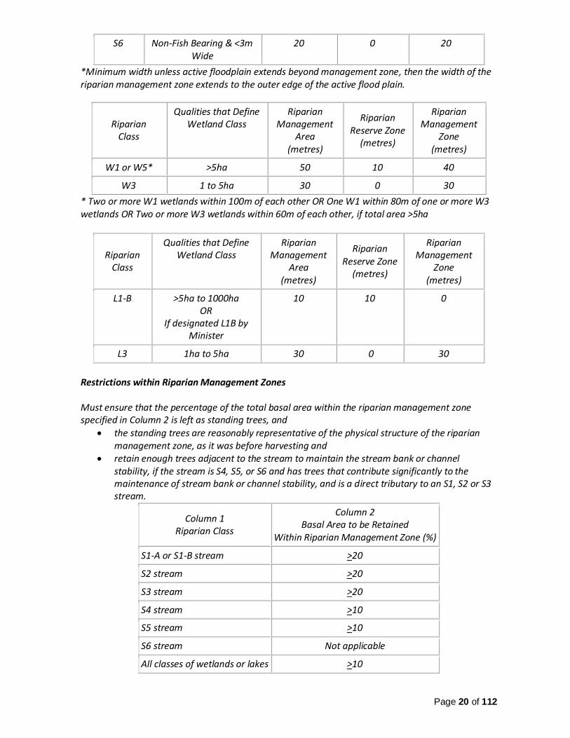
Restrictions within Riparian Management Zones Must ensure that the percentage of the total basal area within the riparian management zone specified in Column 2 is left as standing trees, and
the standing trees are reasonably representative of the physical structure of the riparian management zone, as it was before harvesting and
retain enough trees adjacent to the stream to maintain the stream bank or channel stability, if the stream is S4, S5, or S6 and has trees that contribute significantly to the maintenance of stream bank or channel stability, and is a direct tributary to an S1, S2 or S3 stream.
Column 1 Riparian Class
Column 2 Basal Area to be Retained
Within Riparian Management Zone (%)
S1-A or S1-B stream >20
S2 stream >20
S3 stream >20
S4 stream >10
S5 stream >10
S6 stream Not applicable
All classes of wetlands or lakes >10

Page 21 of 112
The objective is to meet or exceed the regulated practice requirements described above, in order to conserve valuable riparian wildlife habitat, maintain stream channel stability, long-term large woody debris, shading of the stream channel and to minimize new fine organic debris and new sediment input into the stream channels. As such, the target for:
1) S4 streams is to retain >15% of the original basal area within the RMZ; 2) S5 streams is to retain a 20m RRZ, and retain a 20m RMZ with >20% of the original basal
area; 3) S6 streams is to retain >15% of the original basal area within the RMZ of S6 streams that
drain directly into a S1, S2, S3, or S4 stream; 4) W1, W3, and W5 wetlands is to retain >40% of the original basal area within the RMZ
where there is an obvious wildlife feature identified at the time of assessment (e.g., a well-used animal trail, an animal den, raptor nest, mineral lick, heavy ungulate rutting evidence, or heavy ungulate browse) within the RMA; and
5) L1B and L3 lakes is to retain >40% of the original basal area within the RMZ (30m for L3 and 40m for L1B lakes) where, identified at the time of assessment, there is an obvious wildlife feature within the RRZ or RMZ, or where at the time of assessment, regulated game fish are observed or known to be present within a lake.
In the absence of an obvious wildlife feature, the retention for wetlands and lakes will be a riparian reserve zone as identified under “Designated Riparian Management Areas” and the basal area retention as stated under “Restrictions within Riparian Management Zones”.
Water Quality Management
The Forest Planning and Practices Regulation (FPPR) requirements and the additional management plan targets specified under the “Riparian Management” section are designed, in part, to conserve water quality in streams, wetlands, and lakes. It is also recognized that minimizing the sediment delivery to streams from roads and stream crossings is critical to the overall management of water quality. Therefore, it is necessary to implement additional strategies that are known to prevent or reduce road sediment delivery to streams. This includes strategies for road location, design, maintenance and deactivation. These strategies are stated in the development plan and are consistent with the practices identified in the 2013 report by Carson and Maloney7 which considered 4,033 sites assessed under the provincial Water Quality Effectiveness Evaluation.
Watershed Management A description of the major drainages within each Research Forest unit along with each Research Forest unit’s location within 3rd order and higher watersheds is provided in Appendix D. The watersheds are those defined by the provincial Fresh Water Atlas Assessment Watershed boundaries. Streams are those included in the provincial Fresh Water Atlas Stream Network lines.8 The interim watershed hazard scoring is from the maps provided in 2016 by the Omineca Regional office of the Ministry of Forests, Lands and Natural Resource Operations.9 Each Research Forest
7 B. Carson and D. Maloney. 2013. Provincial Water Quality Effectiveness Evaluation Results (2008-2012). Ministry of Forests, Lands and Natural Resource Operations, Resource Practices Br., Victoria BC FREP Report 35. http://www.for.gov.bc.ca/hfp/frep/publications/index.htm 8 GeoBC, Province of British Columbia. 2016. Freshwater Atlas Dataset. http://geobc.gov.bc.ca/base-mapping/atlas/fwa/fwa_data.html 9 Ministry of Forests, Lands and Natural Resource Operations, Omineca Regional Office. 2016. Interim Watershed Hazard Ratings for the Omineca Natural Resource Region.

Page 22 of 112
unit is also examined for its potential impact on future watershed hazard conditions based on the amount of area each unit occupies within each identified watershed, the anticipated level of harvest in the next five years, the potential impact to individual stream basins, and the interim hazard scores assessed by the Ministry of Forests, Lands and Natural Resource Operations. The results of this preliminary study of watersheds are summarized in Table 3. Where future operations within a Research Forest unit may have the potential to negatively impact conditions within one or more watersheds, this is also identified in Table 3. For these streams and watersheds, the strategy is to have a qualified professional undertake a watershed assessment to further understand the predicted watershed hazards and risks. Future forest planning, forest practices and research projects will consider the professional recommendations for reducing downstream impacts to the watersheds identified in this plan. As watershed conditions and planned harvest levels change, the development plan will be annually updated to identify the current watersheds to which this strategy applies. It is acknowledged that the ability to reduce downstream impacts outside of the Research Forest may be limited by how effectively operations may be coordinated with other forest and land tenure holders. Table 3. Summary of Watershed Conditions within Research Forest
Research Forest Unit
Watershed Description Interim Hazard Rating
Potential Watershed Concerns
Watershed Assessment
Recommended
A
Basin that drains directly into Kerry Lake
Stream Flow – VL Sediment – VL Riparian - VL
None N
Basin that drains directly into Crooked River
Stream Flow – L Sediment – M Riparian - M
None N
5th order basin that drains into Weedon Creek
Stream Flow – H Sediment – H Riparian - M
None N
B Basin that drains directly into Tacheeda Lakes
Stream Flow – VL Sediment – VL Riparian - M
None N
Basin that drains into Horseshoe Lake
Stream Flow – L Sediment – VL Riparian - M
None N
C 4th order basin that drains into lower section of Caine Creek
Stream Flow – H Sediment – H Riparian – M
High interim hazard ratings, along with severe spruce beetle and significant planned harvesting
Y
Basin that drains directly into Caine Creek via small streams
Stream Flow – M Sediment – L Riparian - M
See Unit D comments for this watershed
Y
Basin that drains directly into Merton Creek headwaters
Stream Flow – M Sediment – M Riparian - M
None N
Basin that drains directly into Merton Lake and
Stream Flow – M Sediment – M Riparian - M
None N

Page 23 of 112
Merton Creek via small streams
Negligible portion 3rd order basin that drains into Merton Creek
n/a None N
D Basin that forms part of headwaters for Caine Creek
Stream Flow –H Sediment – M Riparian - M
High interim stream flow hazard, along with severe spruce beetle and significant planned harvesting
Y
Negligible portion 4th order basin that drains into lower section of Caine Creek
n/a See Unit C comments for this watershed
Y
Basin that drains directly into Caine Creek via small order streams. Same basin as described for Unit C.
Stream Flow – M Sediment – L Riparian – M
There is a small order stream basin (see Appendix D) that may be largely modified by planned harvesting in Units D and C
N
E Basin that drains directly into the northern branch of Chuchinka Creek
Stream Flow – VL Sediment – VL Riparian – VL
None N
Basin that drains directly into the southern branch of Chuchinka Creek. Together Unit E and F, may have a large potential influence on this watershed.
Stream Flow – VL Sediment – VL Riparian – VM
None N
F Same basin as described immediately above that drains directly into the southern branch of Chuchinka Creek
Stream Flow – L Sediment – L Riparian – M
None N
Basin that drains directly into the mid and lower section of Angusmac Creek
Stream Flow – L Sediment – L Riparian – M
None N
G Basin that drains directly into the mid-section of Angusmac Creek
Stream Flow – L Sediment – VL Riparian – L
None N
Negligible portion of basin that drains into mid and lower section of Angusmac Creek. Same basin as described for Unit F.
n/a None N
4th order basin that flows northward into the Crooked River
Stream Flow – L Sediment – L Riparian – M
None N
Negligible portion of 4th order basin located, mostly south of Unit G, that ultimately drains towards the Crooked River
n/a None N

Page 24 of 112
H Basin that drains directly into the Bowron river via small order streams
Stream Flow – VL Sediment – VL Riparian – M
None N
3rd order basin, mostly to east of Unit H, that drains into the Bowron River
Stream Flow – VL Sediment – VL Riparian – M
None N
I Basin that drains directly into the south side of the Fraser River via small order streams
Stream Flow – L Sediment – H Riparian – L
None N
Basin that drains directly into Hungary Creek via small order streams
Stream Flow – L Sediment – M Riparian – L
There is a small order stream basin (see Appendix D) that may be largely modified by planned harvesting in Unit I
N
J 4th order basin that occupies north western majority of Unit J and drains into Fraser River
Stream Flow – L Sediment – M Riparian – M
None N
Basin that drains directly into the west side of the Fraser River via small order streams
Stream Flow – L Sediment – VH Riparian – L
There is a small order stream basin (see Appendix D) may be largely modified by planned harvesting in Unit J
N
K Basin that drains directly into the east side of the Willow River from small order streams
Stream Flow – H Sediment – M Riparian – M
None N
Basin that drains into Pitoney Creek
Stream Flow – L Sediment – VL Riparian – M
None N
L Basin that drains directly into the east side of the Willow River from small order streams. Same basin as described for Unit K.
Stream Flow – H Sediment – M Riparian – M
None N
Soil Management Soil Disturbance from Permanent Roads The Forest Planning and Practices Regulation requires the following to be met for permanent roads (shown in italics). The objective is to meet or exceed the regulated practice requirements in order to conserve the long-term productivity of the Research Forest landbase. This will be achieved through rehabilitating sections of road that are not required for long-term access.
(1) An agreement holder must ensure that the area in a cutblock that is occupied by permanent
access structures built by the holder or used by the holder does not exceed 7% of the cutblock, unless (a) there is no other practicable option on that cutblock, having regard to
(i) the size, topography and engineering constraints of the cutblock, (ii) in the case of a road, the safety of road users, or

Page 25 of 112
(iii) the requirement in selection harvesting systems for excavated or bladed trails or other logging trails, or
(b) additional permanent access structures are necessary to provide access beyond the cutblock.
(2) If an agreement holder exceeds the limit for permanent access structures described in subsection (1) for either of the reasons set out in that subsection, the holder must ensure that the limit is exceeded as little as practicable.
(3) An agreement holder may rehabilitate an area occupied by permanent access structures by
(a) removing or redistributing woody materials that are exposed on the surface of the area and are concentrating subsurface moisture, as necessary to limit the concentration of subsurface moisture on the area,
(b) de-compacting compacted soils, and (c) returning displaced surface soils, retrievable side-cast and berm materials.
(4) If an agreement holder rehabilitates an area under subsection (3) (a) and erosion of exposed soil from the area would cause sediment to enter a stream, wetland or lake, or a material adverse effect in relation to one or more of the subjects listed in section 149 (1) of the Act, the agreement holder, unless placing debris or revegetation would not materially reduce the likelihood of erosion, must (a) place woody debris on the exposed soils, or (b) revegetate the exposed mineral soils.10
Dispersed Soil Disturbance The value of conserving natural soil properties within the non-roaded areas of cutblocks is recognized as important for ensuring properly functioning ecosystems and watersheds and for maximizing the long-term productivity of the forests. To achieve soil conservation across cutblocks, a management goal for each Research Forest unit, as a whole, is to limit the average dispersed soil disturbance from new harvesting to the following:
1) 5%, which is applicable to the average soil disturbance within all prescribed standard units that are predominantly comprised of sensitive soils in a Research Forest unit,
2) 10%, which is applicable to the average soil disturbance within all prescribed standard units that are not predominantly comprised of sensitive soils in a Research Forest unit, and
3) 25%, which is applicable to the average soil disturbance within all the roadside work areas within a Research Forest unit.
Visual Quality Management
The following Research Forest units are located where visual quality objectives (VQO) have been
established.11
10 Ministry of Forests, Lands and Natural Resource Operations, 2016. Statutes and Regulations Webpages. http://www.bclaws.ca/Recon/document/ID/freeside/14_2004 11 DataBC, Province of British Columbia. 2016. Natural Resources Dataset – Visual Landscape Inventory. https://catalogue.data.gov.bc.ca/dataset?sector=Natural+Resources&download_audience=Public

Page 26 of 112
Unit A: Modification VQO
Two map polygons with a modification VQO are established within the eastern portion of Unit A due to visibility from the Crooked River, Kerry Lake, and/or Highway 97. Unit B: Retention and Partial Retention VQO One narrow visual polygon with a retention VQO is established along the western edge of Unit B along Tacheeda Lakes. Two polygons representing a partial retention VQO are established across the majority of the remaining area within Unit B due to visibility from Tacheeda Lakes. Unit G: Modification VQO A small visual polygon with a modification VQO is established along one of the western facing slopes in the southern part of Unit G due to visibility from Highway 97. Unit H: Modification and Partial Retention VQO One visual polygon with a partial retention VQO and one polygon with a modification VQO occupy the southern portion of Unit H due to visibility from Highway 16 East. The slopes of Mount Bowron, within Unit H, are covered by a polygon with a partial retention VQO due to visibility from Highway 16 East. Unit I: Partial Retention VQO One narrow visual polygon, with a partial retention VQO, occupies the southern edge of Unit I adjacent to Highway 16 East. Unit J: Partial Retention VQO One visual polygon with a partial retention VQO is established over the eastern edge of Unit J due to visibility from the Fraser River. Unit K: Retention VQO One visual polygon with a retention VQO objective is established over the western side of Unit K due to visibility from Tsitniz Lake. Another polygon is established over the southern portion of Unit K due to visibility from Ispah Lake.
The objective for all VQO polygons is to undertake forest development so that the visible landscapes within the VQO polygons meet the definition of altered forest landscape within Sections 1 and 1.1 of the Forest Planning and Practices Regulation. For further reference, the definitions of altered forest landscape specified under the Forest Planning and Practices Regulation are provided in Appendix E.
Recreation Management
Existing and New Recreation Use
For all Research Forest areas, the objective is to support existing and new recreational use of the provincial forest. Strategies to support this objective may include, but are not limited to, the following:
1) maintain road access to all Research Forest units; 2) install signage identifying each Research Forest unit at the main road entrance; 3) install additional signage within or near Research Forest units providing information about
the area, points of interest, or ongoing Research Forest activities; and 4) develop new trails for both short-term and long-term research access, education, and
recreation.

Page 27 of 112
Provincial Parks, Protected Areas, and Ecological Reserves Where operations are near or adjacent to designated parks, protected areas, or reserves, the objectives and strategies pertaining to recreation are those stated under the section “Provincial Designations and Forest/Land Tenures”. Provincial Recreation Sites and Trails The following recreational features are located adjacent to or near Research Forest units.12 ATV & Snowmobile Road Routes – Unit K and L
The Willow-Coalmine Forest Service Road, which runs along the northern boundary of Unit L, is identified as an ATV and snowmobile route when the road is not being actively maintained for industrial purposes. The Willow Forest Service Road (FSR), which runs past the south west corner of Unit K, is identified as an ATV and snowmobile route when the road is not being actively maintained for industrial purposes.
Tsitniz Lake / Camp Friendship and Recreation Reserve – Unit K Camp Friendship is located next to Tsitniz Lake. A provincial Recreation Reserve encloses the area around Tsitniz Lake and the nearby area between the Willow Forest Service Road and the Willow River.
Ispah Lake – Unit K
A provincial Recreation Site is established on Ispah Lake along the Willow FSR, just south of Unit K.
Tacheeda Lakes Recreation Sites – Unit B
The Tacheeda Lakes Middle and Tacheeda Lakes Point Recreation Sites are established on Tacheeda Lakes just north of Unit B.
Tacheeda Lookout Trail
A provincial Recreation Trail has been established along the trail to the Tacheeda Fire Lookout site. This trail runs towards the east, just north of Unit B.
Fishhook Lake Recreation Site – Unit B A provincial Recreation Site is established on Fishhook Lake, just south of Unit B.
The strategy for all these recreation features is to consult and seek input from the Ministry of Forests, Lands and Natural Resource Operations when undertaking forest development and research project planning. The coinciding strategy is to achieve results from forest development, silviculture practices, and research projects that are consistent with the continued recreational use and enjoyment of the existing sites, trails, and camps.
12 DataBC, Province of British Columbia. 2016. Natural Resources Dataset – Visual Landscape Inventory. https://catalogue.data.gov.bc.ca/dataset?sector=Natural+Resources&download_audience=Public

Page 28 of 112
Road and Trail Access Management The objective is to maintain a reliable road network, and trail network where applicable, to and within each Research Forest unit to support continuing access for forest operations, educational sites, research sites, First Nation use, stakeholder use, and general recreational use by the public. For roads that are required for temporary operational or research access the objective is to reduce their footprint to conserve the available productive forest soils and to reduce water quality and watershed impacts over the long-term. This will be accomplished by rehabilitating or deactivating the non-necessary road sections. Rehabilitation will occur as described under section 36 of the Forest Planning and Practices Regulation and therefore will involve re-vegetating the former road area.
Research Site Locations
CNC and its research partners have established numerous sites and areas that have and are supporting natural resource monitoring, studies, and trials. Some of these sites and areas are used for multiple years of study while others may only be used for one season. Tracking these sites over time is important as there may be value in revisiting inactive sites to support or complement future study and research. The previously established research site locations that are within or immediately adjacent to the Research Forest units are shown on the maps in Appendix F along with a table summarizing specific information for each research site. In addition to the sites established by CNC, one pre-existing provincial research site has been identified within the CNC Research Forest. It is located in Unit D and is shown on provincial maps as EP 0886.13.09. It is identified as a fertilization trial. Its approximate location is shown on the Unit D map in Appendix F. Depending on its current condition and the applicability of the previous data collected, this site may be excluded from harvesting, road development, and silviculture practices for a significant period of time. The development plan, which provides more specific guidance for future forest and research operations, will be annually updated for new additions and changes to research site locations.
Provincial Designations and Forest/Land Tenures
The following provincial Parks, Protected Areas, and Ecological Reserves were identified using the
geographic data provided by DataBC, Province of British Columbia.13
Tacheeda Lakes Ecological Reserve
Unit B of the Research Forest is situated immediately adjacent to the west side of the Tacheeda Lakes Ecological Reserve. The reserve is composed of 526ha of mostly mature spruce-leading forests within the McGregor Plateau ecosection of which only 0.64% is under designated
13 DataBC, Province of British Columbia. 2016. Natural Resources Dataset – Visual Landscape Inventory. https://catalogue.data.gov.bc.ca/dataset?sector=Natural+Resources&download_audience=Public

Page 29 of 112
protection. Although small, the ecological reserve contributes 11.85% of the overall protected areas system of the McGregor Plateau.14 The primary purpose of this Provincial Ecological Reserve is to protect the mature forest ecosystems representative of the wet cool Sub-Boreal Spruce subzone (SBSwk1 subzone) and its transition with the Engelmann Spruce-Subalpine Fir Zone (ESSFwk2 subzone).15 This type of Provincial Reserve is not created for outdoor recreation. Most ecological reserves, however, are open to the public for non-destructive pursuits like hiking, nature observation and photography. As well, research and educational activities may be carried out but only under permit.16 Sugarbowl-Grizzly Den Provincial Park and Protected Area
Unit I is situated immediately east of the northern part of the Sugarbowl-Grizzly Den Park and Protected area. The primary roles of the park and protected area are to protect critical habitat for the Mountain Caribou, protect the historically significant Grand Canyon of the Fraser, and to provide outstanding backcountry recreation opportunities within one hour of Prince George via the Sugarbowl and Viking Ridge Trails. The secondary role of the park and protected area is to provide representation of the Upper Fraser Trench ecosection and the Interior Cedar-Hemlock very wet, cool variant (ICHvk2) biogeoclimatic zone.17 Fraser River Provincial Park
Unit J is situated immediately adjacent to the southern boundary of Fraser River Park which encompasses an area along the west side of Fraser River just north of the confluence of Naver Creek and the Fraser River. The primary role of Fraser River Park is to provide representation of the Quesnel Lowlands ecosection, and moist hot and dry warm Sub-boreal Spruce forests. Fraser River Park currently provides the greatest extent of representation in the protected areas system of the Quesnel
14 British Columbia Ministry of Environment, Omineca Region. 2005. BC Parks Webpages, Tacheeda Lake Ecological Reserve: Purpose Statement and Zoning Plan. http://www.env.gov.bc.ca/bcparks/planning/mgmtplns/tacheeda_lake_er/tacheeda_lake_er_ps.html 15 British Columbia Ministry of Environment, Omineca Region. 2005. BC Parks Webpages, Tacheeda Lake Ecological Reserve: Purpose Statement and Zoning Plan. http://www.env.gov.bc.ca/bcparks/planning/mgmtplns/tacheeda_lake_er/tacheeda_lake_er_ps.html 16 British Columbia Ministry of Environment. 2013. BC Parks Webpages, Tacheeda Lakes Ecological Reserve Webpage. http://www.env.gov.bc.ca/bcparks/eco_reserve/tacheeda_er.html 17 British Columbia Ministry of Environment, Omineca Region. 2005. BC Parks Webpages, Sugarbowl-Grizzly Den Provincial Park and Protected Area: Purpose Statement and Zoning Plan. http://www.env.gov.bc.ca/bcparks/planning/mgmtplns/sugarbowl_grizzly/sugarbowl_grizzly_ps.pdf?v=1450743905560

Page 30 of 112
Lowlands ecosection and Sub-boreal Spruce moist hot (SBSmh) and Sub-Boreal Spruce dry warm, Blackwater variant biogeoclimatic zones. In the future, a secondary role will be to provide backcountry recreation access to the Fraser River, and opportunities for wildlife and nature-related recreation associated with a large river valley.18 The area provides excellent elk, deer and moose winter range. The high ungulate winter range values can be attributed to the south easterly facing slopes, the lower elevation and milder climate which contributes to a lower snow depth.19 The strategy for all of the Parks and the Ecological Reserves is to consult with available expertise within the British Columbia Ministry of Environment and the British Columbia Ministry of Forests, Lands and Natural Resource Operations when proposing operations immediately adjacent to the Parks or Reserve Boundaries. The coinciding strategy is to achieve outcomes from forest and research operations that do not limit the achievement of the current, primary purposes, and secondary purposes where applicable, of the potentially affected Parks and Ecological Reserves.
Adjacent or Overlapping Provincial Resource Stakeholders Tree Farm License 30
Tree Farm License 30, held by Canadian Forest Products Ltd, is located immediately adjacent to the eastern boundary of Unit G of the Research Forest.20 Forestry License to Cut, Special Use Permit, Road Permit, and Road-use Permit Holders
It is recognized that over time, there may be forestry licenses to cut and special use permits issued and held by various persons who may be operating adjacent to Research Forest units. In most cases, it is expected that these users will be advised of the CNC Research Forest when issued their license or permit and that they will contact CNC as necessary to coordinate planning and operations. Forest License Holders
There are numerous holders of small and large volume-based forest licenses within the Prince George Timber Supply Area who operate immediately adjacent to the Research Forest and who may require new road access or the use of existing roads within the Research Forest.
18 British Columbia Ministry of Environment, Omineca Region. 2005. BC Parks Webpages, Fraser River Provincial Park: Purpose Statement and Zoning Plan. http://www.env.gov.bc.ca/bcparks/planning/mgmtplns/fraser_river/fraser_river_ps.pdf?v=1459895694354 19 British Columbia Ministry of Environment, Omineca Region. 2005. BC Parks Webpages, Fraser River Provincial Park: Purpose Statement and Zoning Plan. http://www.env.gov.bc.ca/bcparks/planning/mgmtplns/fraser_river/fraser_river_ps.pdf?v=1459895694354 20 DataBC, Province of British Columbia. 2016. Natural Resources Dataset – Tree Farm License. https://catalogue.data.gov.bc.ca/dataset?sector=Natural+Resources&download_audience=Public
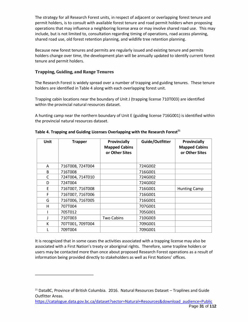
Page 31 of 112
The strategy for all Research Forest units, in respect of adjacent or overlapping forest tenure and permit holders, is to consult with available forest tenure and road permit holders when proposing operations that may influence a neighboring license area or may involve shared road use. This may include, but is not limited to, consultation regarding timing of operations, road access planning, shared road use, old forest retention planning, and wildlife tree retention planning. Because new forest tenures and permits are regularly issued and existing tenure and permits holders change over time, the development plan will be annually updated to identify current forest tenure and permit holders. Trapping, Guiding, and Range Tenures The Research Forest is widely spread over a number of trapping and guiding tenures. These tenure holders are identified in Table 4 along with each overlapping forest unit. Trapping cabin locations near the boundary of Unit J (trapping license 710T003) are identified within the provincial natural resources dataset. A hunting camp near the northern boundary of Unit E (guiding license 716G001) is identified within the provincial natural resources dataset. Table 4. Trapping and Guiding Licenses Overlapping with the Research Forest21
Unit Trapper Provincially Mapped Cabins or Other Sites
Guide/Outfitter Provincially Mapped Cabins or Other Sites
A 716T008, 724T004
724T002 724G002
B 716T008 716G001 C 724T004, 714T010 724G002
D 724T004 724G002
E 716T007, 716T008 716G001 Hunting Camp
F 716T007, 716T006 716G001
G 716T006, 716T005 716G001
H 707T004 707G001
I 705T012 705G001
J 710T003 Two Cabins 710G003
K 707T001, 709T004 709G001
L 709T004 709G001
It is recognized that in some cases the activities associated with a trapping license may also be associated with a First Nation’s treaty or aboriginal rights. Therefore, some trapline holders or users may be contacted more than once about proposed Research Forest operations as a result of information being provided directly to stakeholders as well as First Nations’ offices.
21 DataBC, Province of British Columbia. 2016. Natural Resources Dataset – Traplines and Guide Outfitter Areas. https://catalogue.data.gov.bc.ca/dataset?sector=Natural+Resources&download_audience=Public

Page 32 of 112
Units K and L, near the Willow River, are located within a range tenure associated with the licensed
hunting guide territory.22
The strategy, in respect of the overlapping trapping, guiding and range tenures, is to consult with available trappers and guides (guides hold the range tenures) when proposing operations that may influence a trapline, guiding area, or range resources. This may include, but is not limited to, consultation regarding timing of operations, road access planning, shared road use, old forest retention planning, and wildlife tree retention planning. The specific timing of operations may be very important to trapping, guiding, and range tenure holders. Therefore, prior to initiating operations that may influence their territories, the holder will be notified of the commencement date and the approximate duration. Because trapping and guiding license holders change over time and new range tenures may be issued, the development plan will be annually updated to identify current trapping, guiding, and range tenure holders. Mining Tenure and Notice of Work There are mining tenures within all the units of the Research Forest, but there is only one active Notice of Work for current exploration or mining activities, which is located in the area of Unit L along the Willow River.23 With respect to the ongoing mining operations affecting Unit L and in the event of a new Notice of Work, the strategy for all Research Forest units is to consult with available expertise within the British Columbia Ministry of Energy and Mines and the British Columbia Ministry of Natural Gas Development and consult with the exploration/mining proponent in coordinating forestry development and research activities with exploration and mining activities. This may include, but is not limited to coordination of road access management, old forest retention planning, and wildlife tree retention planning. Other Land Tenures
A communications site and an associated access right-of-way is located within the southern end of Unit G. The objective, in respect of the overlapping land tenure right-of-way, is to appropriately involve the Ministry of Forests, Lands and Natural Resource Operations in planning regarding forest development and research projects, so that any existing and future use of the communication site and right-of-way may be appropriately accommodated.
22 DataBC, Province of British Columbia. 2016. Natural Resources Dataset – Range Tenure. https://catalogue.data.gov.bc.ca/dataset?sector=Natural+Resources&download_audience=Public 23 DataBC, Province of British Columbia. 2016. Natural Resources Dataset – Mineral, Placer and Coal Tenure. https://catalogue.data.gov.bc.ca/dataset?sector=Natural+Resources&download_audience=Public

Page 33 of 112
Adjacent Land Owners The western boundary of Research Forest Unit B is immediately adjacent to privately held land as is displayed on the management plan Content Maps within Appendix G.24 The strategy, in respect of these lands is to consult with the land owner when proposing operations that may influence the adjacent lands. This may include, but is not limited to, consultation regarding timing of operations, road access planning, shared road use, visual quality planning, old forest retention planning, and wildlife tree retention planning.
Archaeological and Cultural Heritage Resources There are no previously identified archaeological sites within or immediately adjacent to the Research Forest units, but there is potential for new findings with the completion of future assessments. There is also potential for future cultural heritage resource findings within or adjacent to Research Forest units. When discussing cultural heritage resources, this plan is referring to resources, sites or features important to the culture, traditional use, treaty rights and aboriginal rights of a First Nation. It is recognized that a cultural heritage resource may have various meanings that are unique to a First Nation and unique to a Nation’s treaty and aboriginal rights. By regularly referring proposed operations to affected First Nations, there will be multiple opportunities for a First Nation to communicate about cultural heritage resources and provide the necessary knowledge, advice, and input to CNC. The objective with respect to Archaeological and Cultural Heritage Resources is to provide reasonable opportunities for potentially affected First Nations to be involved in the assessment and the management of archaeological and cultural heritage resources. In order to achieve this objective, the following strategies will be undertaken: 1) offer opportunities for First Nations members to be involved in identifying and assessing
archaeological and cultural heritage resources; 2) all proposed cutblocks and roads will be referred to the affected First Nation(s) for a period of
30 days in advance of operations (or another length of time as agreed with the affected First Nations), so that the First Nations have an opportunity to offer knowledge and input;
3) where operations are planned to remove forest cover, the following assessments will be undertaken to identify archaeological and cultural heritage resources and to provide recommendations regarding their conservation and protection: a) where an area is not covered by a provincially recognized Archaeological Predictive Model
or a previous Archaeological Overview Assessment, an Archaeologist will undertake an Archeological Overview Assessment and/or Preliminary Field Assessment to identify potential archaeological sites and to identify cultural heritage resources;
b) where an area is covered by a provincially recognized Archaeological Predictive Model or Mapping or a previous Archaeological Overview Assessment, an Archaeologist will
24 DataBC, Province of British Columbia. 2016. Geographic Dataset – TANTALIS – Crown Tenures. https://catalogue.data.gov.bc.ca/dataset?q=tantalis&download_audience=Public&type=Geographic&sort=score+desc%2C+record_publish_date+desc&page=1

Page 34 of 112
undertake an Archeological Overview Assessment and/or Preliminary Field Assessment to identify potential archaeological sites and to identify cultural heritage resources; and
c) Where the potential for a cultural heritage feature is identified by a First Nation or a person with interests in the area, an Archaeologist will undertake an Archaeological Overview Assessment and/or Preliminary Field Assessment to identify cultural heritage features or potential archaeological features.
d) where there is potential for archaeological resources as identified by a First Nation, a person with interests in the area, an Archaeological Predictive Model, an Archaeological Overview Assessment or Preliminary Field Assessment, an Archaeologist will undertake or oversee an Archaeological Impact Assessment;
4) archaeological or cultural heritage resource findings from any field assessments completed by an Archaeologist are to be shared with the affected First Nation(s) for a period of 30 days in advance of operations (or another length of time as agreed to with the affected First Nations), so that the First Nation(s) has a reasonable time to offer knowledge and input;
5) reasonable efforts to incorporate a First Nation’s input regarding conservation or protection of an archaeological or cultural heritage site will be undertaken, particularly as it relates to a treaty right or an aboriginal right; and
6) where a previously unidentified site, which is expected to be an archaeological or cultural heritage site, is discovered while undertaking a forest practice or research, the forest practice or research will be modified or stopped to protect the remaining site until it may be assessed, referred, and incorporated into plans and final designs as described in items 1 to 5 above.
Forest Health Management As per the “Current Management Challenges” section of this management plan, the Research Forest is expected to experience notable occurrences of forest pathogens, insects, and other forms natural damage within all types of forest stands. This presents a regular challenge for on-going timber supply management and for implementing strategies to conserve and protect various forest resources. Given the significant ongoing and future forest health hazard for both mature and young timber, forest health management is expected to be an ongoing management focus.
All Forest Health Factors
The objective for forest health management is to minimize the risk to timber loss while conserving and protecting natural resources consistent with all the objectives within this plan. This is to be achieved by (the following strategies do not apply to existing pine mortality from mountain pine beetle):
1) implementing annual aerial detection and assessment of forest health factors; 2) implementing ground reconnaissance, inspections, or assessments for any areas identified
having a non-endemic level of forest health factors from aerial detection or other fieldwork;
3) undertaking previously recognized insect trapping and baiting treatments to hold or suppress insect populations where there are non-endemic levels of insect attack and where adjacent stands are assessed with a high hazard for insect attack;
4) undertaking experiments within mature forests, young forests, and clearcut areas to evaluate new trapping and baiting treatments for conifer bark beetles.
5) undertaking sanitation and salvage harvesting treatments of various sizes and forms within stands greater than 50 years old, prior to sawlog shelf-life expiry, where there is a moderate to high likelihood of the stand being reduced to less than 140m3/ha of net live conifer timber;
6) where possible, coordinate forest health treatments with adjacent forest tenure holders to improve effectiveness of treatments for areas within and outside of the Research Forest;

Page 35 of 112
7) subject to considering biodiversity, riparian, water quality, and wildlife habitat values, undertaking sanitation treatments, and re-stocking if necessary, in young, managed stands (0 to 20 years old) where there is moderate to high likelihood of not achieving 160m3/ha of conifer yield by age 65 without treatment (the volume threshold will be evaluated on the average yield of the existing cutblock containing the effected stand);
8) subject to considering biodiversity, riparian, water quality, and wildlife habitat values and subject to provincial funding, undertaking partial cut or clearcut sanitation and salvage harvesting treatments, and re-stocking, if necessary, in intermediate aged stands (21 to 50 years of age) where there is moderate to high likelihood of not achieving 160m3/ha of conifer yield by age 65 without treatment (The volume threshold will be evaluated on the average yield of the existing cutblock or the expected future cutblock containing the effected stand. The maximum forecasted mid-term timber supply effect of forest health treatments in stands 21 to 50 years old is to be less than an average of 500m3/year during the 10 to 60-year period.); and
9) when considering isolated occurrences of forest health factors, other than bark beetle, the minimum treatment size is 15ha.
When undertaking harvesting treatments under objectives 3, 4 or 6, the objectives concerning retention of trees are to be achieved regardless of forest health factors.
Mountain Pine Beetle Salvage The remaining areas of mountain pine beetle damaged pine-leading stands within the Research Forest are now reaching the end of their economic shelf-life due to remaining volume per hectare and degradation of wood quality. The objective for pine-leading stands killed by mountain pine beetle is to salvage remaining fibre value and return sites to productive conifer forests, subject to considering biodiversity, riparian, water quality, and wildlife habitat values. This will be achieved through the following strategies:
1) salvage harvesting damaged pine-leading areas greater than 15ha, if there is remaining pine sawlog shelf-life as determined through an in-field assessment, where the average net tree size is greater than 0.18m3/tree and average tree height is greater than 22m and where the remaining live trees are not expected to achieve 160m3/ha of conifer yield by age 65 (this only applies when undertaking the harvest of adjacent stands where the average volume per hectare across all the areas – pine salvage area and adjacent stands -- is greater than 180m3/ha of net conifer timber); and
2) isolated damaged pine-leading stands less than 15ha or stands that have exceeded sawlog shelf live as determined from an in-field assessment, will be considered for rehabilitation treatments and full re-stocking where the remaining live trees are not expected to achieve 160m3/ha of conifer yield by age 65 (rehabilitation treatments are dependent on the availability of provincial funding).
Spruce Beetle Sanitation and Salvage A very large outbreak of spruce beetle attack on mature spruce trees is being experienced largely in the northeast portion of the Prince George Forest District (Parsnip River and Crooked River drainages). At the time of writing this management plan, this current outbreak has affected the majority of the mature spruce timber throughout Research Forest Units C and D. As well, a large amount of attack has been detected in Units E, F, and G. Greater than endemic levels of spruce beetle attack have also been observed in portions of Unit B.

Page 36 of 112
The objective with respect to spruce beetle is to rapidly reduce beetle populations within all Research Forest units and rapidly recover the commercial value of attacked trees. This will be achieved through the following results and strategies:
1) within areas that are not prescribed for the conservation of natural resources, the goal is to limit non-salvaged losses from spruce beetle to 20,000m3 over five years;
2) undertaking the regular detection, treatment, sanitation, and salvage of spruce beetle affected areas as per the strategies under the section “All Forest Health Factors”; and
3) collaborating with business partners to implement hauling and milling strategies consistent with current best management practices distributed by the Ministry of Forests, Lands, and Natural Resource Operations.
Vegetation Management Invasive Plants The objective is to minimize the introduction and spread of invasive plant species where Research Forest operations causes soil disturbance. Where the invasive plants are found to occur within the Research Forest, the objective is report the occurrences and support necessary treatments to reduce or remove the invasive plants. Strategies to achieve these objectives may include, but are not limited to the following:
1) revegetate portions of disturbed soil to reduce the conditions favorable to establishment of invasive plants;
2) rehabilitate unnecessary short-term roads so they are not a vector for the establishment of invasive plants;
3) record the occurrence of the species identified as noxious within all regions of the Province and those identified as noxious within the Fraser-Fort George Region as per the Field Guide to Noxious Weeds and Other Selected Invasive Plants of British Columbia;
4) report the occurrence of invasive species to the Northwest Invasive Plants Council so that they may determine any necessary treatments to reduce or remove invasive plants; and
5) subject to available resources, provide assistance and support to the Council in undertaking invasive plants treatments.
Deciduous and Brush Competition for Conifer Trees Deciduous trees, brush-type plants, and herbaceous plants are valued for their contribution to fish and wildlife habitat and overall ecosystem and species diversity. However, where they are suppressing conifer growth, deciduous and brush competition may require direct treatment to achieve the stocking and timber objectives in this plan. The objective is to reduce deciduous and brush competition where prescribed stocking standards are at risk of not being met or free growing achievement may be significantly delayed. This will be achieved by:
1) implementing a variety of brushing treatments, including but not limited to, manual brushing treatments, prescribed fire, animal grazing, and herbiciding to remove or suppress the growth of deciduous trees, brush-type plants, and herbaceous plants where conifer-leading regeneration is prescribed;
2) undertaking experiments within cutblocks to evaluate new brushing and vegetation suppression techniques targeted at deciduous trees, brush species, and herbaceous plant species;
3) consulting with potentially affected stakeholders and First Nations when proposing any herbiciding operations for a period of 30 days in advance of operations (or another length

Page 37 of 112
of time as agreed to with the affected stakeholders and First Nations), so that the stakeholders and First Nations have an opportunity to offer knowledge and input; and
4) limiting the type or amount of brushing treatments if they may materially affect the retention of trees and other plants that are important to achieving objectives within areas prescribed for the conservation and protection of natural resources.
Timber Growth and Yield Management Managing Timber for Forest Products Consistent with the current and foreseeable demand for timber products, the objective is to manage forests stands to maximize the yield of sawlog quality conifer trees. For all Research Forest units, this means a priority on the production of quality spruce trees. Despite the previous, it is recognized that the dominance of spruce regeneration may be reduced in respect of other tree species that are expected to be better adapted for yield under predicted climate and ecosystem conditions. In order to help inform future tree regeneration and future timber yield decisions, applied research and innovation is expected to continue regarding tree species adaptation and survival outside of their current natural range of ecology and climate. Non-Sawlog Wood Fibre The objective for non-sawlog wood fibre is to explore, study, and implement options for recovering and utilizing all wood fibre that is remaining after fulfilling the conservation and protection objectives for all forest resource values.
Natural Non-Productive Forest and Natural Non-Commercial Cover Areas that were naturally non-productive forest or non-commercial cover (brush cover) are valued for their unique habitat qualities and contribution to overall ecosystem and species diversity. The objective for any individual area that is naturally non-productive or non-commercial cover (equal to or greater than 0.2ha) is to avoid reforestation and avoid alteration of the soil and soil moisture attributes. The existing vegetation cover in these areas may be disturbed at the time of harvest to facilitate efficient operations.
Problem Forest Types Areas that are naturally hemlock and cedar leading forests are valued for their unique habitat qualities and contribution to overall ecosystem and species diversity. As described under the section titled, “Interior Old Forest Objective”, natural hemlock and cedar leading stands within Unit I will be conserved for biodiversity. Within Unit H, the objective is to further explore the economic recovery of timber and wood fiber value from hemlock and cedar stands. The conversion of mature hemlock and cedar leading stands to other conifer species may be undertaken; however, a representative portion of the natural hemlock and cedar stands will be retained consistent with the “Old Forest Retention” and “Wildlife Tree Retention” sections.
Regeneration of Forest, Use of Seed, and Free Growing Stands
Regeneration of forests remains a fundamental goal that is vital to achieving this plan’s many other objectives for future timber products and the maintenance of ecosystem and wildlife habitat functioning.

Page 38 of 112
Tree Seed The objective is to realize the growth and yield benefits from provincial tree seed improvement, while allowing experimentation with different seed sources to facilitate continuing study into assisted tree species migration and species adaptation to climate change. The Chief Forester’s Standards for Seed Use will be used in the selection and utilization of seed for conifer regeneration in cutblocks within all Research Forest units. The application of the seed that does not meet the Chief Forester’s Standards is subject to not significantly increasing the risk to future timber supply and subject to achieving the conservation and protection objectives for all natural resource values.
Tree Species and Tree Density Selection The objective is to realize the growth and yield benefits from implementing provincial stocking standards while allowing experimentation to facilitate continuing study into assisted tree species migration and species adaptation to climate change. The provincial Reference Guide for FDP Stocking Standards will be used to prescribe preferred and acceptable conifer tree species and minimum stocking densities within each differing ecosystem association within each cutblock. To facilitate further study, the following exceptions to the provincial standards may be implemented.
1) There is strong preference for regenerating spruce on all Research Forest units, but this preference may be reduced in respect of other tree species that are expected to be better adapted for growth and yield under the predicted climate and ecosystem conditions.
2) The experimentation and monitoring of planted conifer species expected to be better adapted for growth and yield under predicted climate and ecosystem conditions may be a focus of research in all Research Forest units. The planting of such tree species is subject to not significantly increasing the risk to future timber supply and subject to achieving the conservation and protection objectives for all natural resource values.
3) Where it may be demonstrated that long-term yield is not expected to be reduced, then different free growing criteria may be applied than is recognized through the provincial Reference Guide for FDP Stocking Standards. Different procedures for assessing free growing may also be applied than is recognized in the provincial Silviculture Surveys Procedures Manual.
4) To increase conifer yield (volume per hectare) and conifer timber quality (reduced large branch production), increasing target planting densities will be considered for all ecosystem associations showing a target stocking of 1000 stems/ha or greater within the provincial Reference Guide for Stocking Standards. The total density considered will be supported by growth modelling or best information that demonstrates the beneficial volume gains.
5) Within prescribed riparian management areas, the achievement of free growing status is dependent on each assessed tree meeting a minimum height, along with minimum form and health criteria. Conifer free growing status is not dependent on conifer height relative to competing brush species or deciduous trees or conifer position relative to competing brush species or deciduous trees.

Page 39 of 112
Tree Regeneration Delay
The objective is to minimize average conifer regeneration delay to minimize the time that any area is not yielding conifer volume. The expectation is that the majority of tree planting will be implemented the next spring or summer season following the completion of harvesting.
Tree Planting The objective is to optimize the site selection for the majority of planted trees to ensure improved conifer seedling survival and initial growth. As such, a minimum intertree spacing of 1.6m may prescribed for any ecosystem association. A minimum intertree spacing of less than 1.6m may be prescribed where site conditions, soil conditions or necessary site preparation severely limit optimum planting sites. Silviculture Treatments The objective is to minimize silviculture treatment time to minimize the time that any area is not yielding acceptable conifer volume or quality. Where a prescribed conifer area is determined to require silviculture treatments, such as, but not limited to, site preparation, brushing, fill-planting, or forest health sanitation, then the treatment(s) is to be undertaken within two growing seasons of detection.
Allowable Annual Cut Analysis
Current Timber Supply Analysis and Modelling New timber supply analysis and harvest modelling was undertaken to update the landbase for disturbance history up to and including winter 2015/16 harvesting, adjust the tree age classes to January 2016, and most importantly to account for current and future spruce mortality due to the epidemic occurrence of spruce beetle. Sensitivity analysis was also undertaken to evaluate differing levels of spruce beetle attack and differing old forest retention targets.
Remsoft Spatial Planning System (Woodstock) was used to complete the timber supply analysis, the same as used for the previous analysis for the 2013 management plan. A full summary of the current timber supply analysis is provided in Appendix H.
The Timber Harvesting Land Base Netdown The timber harvesting land base (THLB) was only adjusted for the new road construction since the last analysis. This resulted in a reduction of six hectares from the previous THLB identified in 2012. The updated THLB net down table for the Research Forest is shown in Table 5. Table 5. Timber Harvesting Land Base Net Down
Land Base Classification 2013
Area (ha)
2016
Area (ha)
Gross Area of CNCRF 12,581 12,580
Non-Forest & Non-Productive 149 149

Page 40 of 112
Existing roads 169 174
Crown Forested Land Base (CFLB) 12,263 12,257
Physically Inoperable Areas 12 12
Problem Forest Types & Deciduous 654 654
Riparian Reserve Zones 214 214
Total Non-Contributing Land Base (NCLB) 880 880
Current Timber Harvesting Land Base (THLB) 11,383 11,377
Yield Tables Yield tables have not changed from the previous analysis with the exception of changing the periods from 10-years to 5-years. The 5-year periods used in this analysis better capture the short-term impacts of spruce beetle and the potential harvest levels associated with spruce sanitation and salvage.
Assumptions Applied in Analysis Pine Mortality There are currently 429 hectares of pine-leading stands within the THLB (defined as greater than 70% pine volume and greater than 65 years old). Due to the substantial decline in available volume and remaining sawlog quality within these stands, only 89 hectares were identified for salvage harvesting in the analysis. The remaining pine-leading areas are assumed to reach shelf-life expiry in five years, then regenerate naturally after a 10-year regeneration delay. All of the pine volume within the pine-leading stands mentioned previously was reduced by 40% to reflect the current volume net-down applied when timber cruising dead pine stands. A 30% volume reduction was applied to all other pine-leading stands, where pine is equal to or less than 70% of the volume.
Spruce Mortality The Base Case timber supply analysis assumes a moderate increase of spruce beetle attack and mortality above the spruce beetle areas identified in the Ministry of Forests, Lands and Natural Resource Operations’ 2015 aerial overview information. This was accomplished by identifying all spruce leading stands greater than 120 years of age, then starting with the oldest stands first, applying mortality to the entire stand volume until the desired percentage of spruce mortality (by volume) is obtained. This predicted moderate advancement of spruce appears reasonable as winter 2016 beetle probing shows that substantial spruce beetle attacked has already advanced beyond the recorded 2015 spruce beetle polygons in the Angusmac Creek and Tacheeda Lakes areas. For the Base Case, 85% spruce mortality (by volume) was applied within Units C, D, and G, while 40% mortality was applied within Units A, B, E, and F. 20% Mortality was applied to stands in Units H, I, J, and K. No mortality was applied to Unit L as it had no susceptible spruce stands, based on age. The above equates to 31,604m3 of spruce mortality applied to Units H to K, and 532,707m3 of spruce mortality applied to Units A to G located in the northern portion of the Prince George Natural Resource District. The assumed shelf-life of spruce beetle killed stands was one period (5 years). If not harvested by the end of the period, they were assumed to regenerate naturally after a 10-year delay.
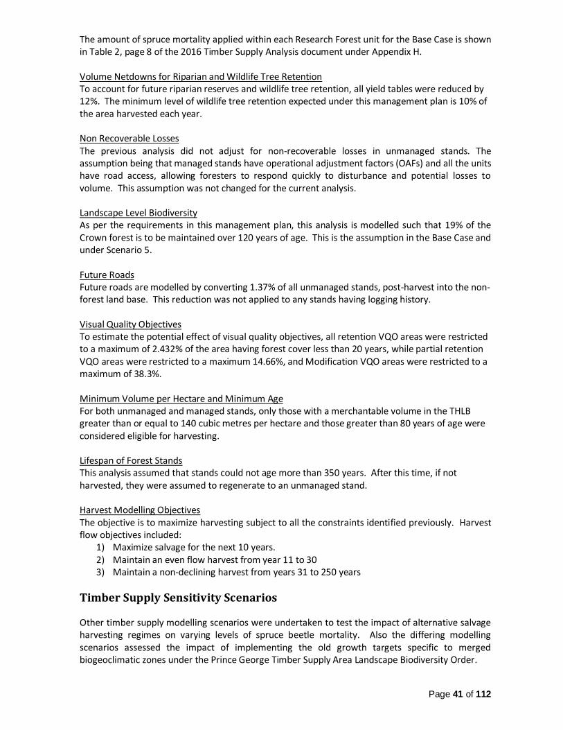
Page 41 of 112
The amount of spruce mortality applied within each Research Forest unit for the Base Case is shown in Table 2, page 8 of the 2016 Timber Supply Analysis document under Appendix H. Volume Netdowns for Riparian and Wildlife Tree Retention To account for future riparian reserves and wildlife tree retention, all yield tables were reduced by 12%. The minimum level of wildlife tree retention expected under this management plan is 10% of the area harvested each year. Non Recoverable Losses The previous analysis did not adjust for non-recoverable losses in unmanaged stands. The assumption being that managed stands have operational adjustment factors (OAFs) and all the units have road access, allowing foresters to respond quickly to disturbance and potential losses to volume. This assumption was not changed for the current analysis. Landscape Level Biodiversity As per the requirements in this management plan, this analysis is modelled such that 19% of the Crown forest is to be maintained over 120 years of age. This is the assumption in the Base Case and under Scenario 5. Future Roads Future roads are modelled by converting 1.37% of all unmanaged stands, post-harvest into the non-forest land base. This reduction was not applied to any stands having logging history. Visual Quality Objectives To estimate the potential effect of visual quality objectives, all retention VQO areas were restricted to a maximum of 2.432% of the area having forest cover less than 20 years, while partial retention VQO areas were restricted to a maximum 14.66%, and Modification VQO areas were restricted to a maximum of 38.3%. Minimum Volume per Hectare and Minimum Age For both unmanaged and managed stands, only those with a merchantable volume in the THLB greater than or equal to 140 cubic metres per hectare and those greater than 80 years of age were considered eligible for harvesting. Lifespan of Forest Stands This analysis assumed that stands could not age more than 350 years. After this time, if not harvested, they were assumed to regenerate to an unmanaged stand. Harvest Modelling Objectives The objective is to maximize harvesting subject to all the constraints identified previously. Harvest flow objectives included:
1) Maximize salvage for the next 10 years. 2) Maintain an even flow harvest from year 11 to 30 3) Maintain a non-declining harvest from years 31 to 250 years
Timber Supply Sensitivity Scenarios Other timber supply modelling scenarios were undertaken to test the impact of alternative salvage harvesting regimes on varying levels of spruce beetle mortality. Also the differing modelling scenarios assessed the impact of implementing the old growth targets specific to merged biogeoclimatic zones under the Prince George Timber Supply Area Landscape Biodiversity Order.

Page 42 of 112
Sensitivity analysis examined the following four scenarios as follows: 1) In Scenario 2, the level of spruce mortality for Units C and D and G was assumed to be 85%,
but only in the areas identified as spruce-beetle killed through visual detection via the Ministry of Forests, Lands and Natural Resource Operations’ aerial overview survey from summer 2015. The aerial overview survey had not identified spruce beetle in the other Units, so 0% mortality was assumed in these areas.
2) In Scenario 3, severe mortality to spruce-leading stands > 120 years was assumed within Units A, B, C, D, E, F, G, starting with the oldest stand first, until 85% of the spruce volume within each unit was dead. Spruce mortality was applied to spruce-leading stands > 120 years within Units H, I, J, K starting with oldest stand first, until 40% of the spruce volume in each unit was dead.
3) In Scenario 4, the mortality assumptions from Scenario 2 were applied along with the targets for Old Growth within each merged biogeoclimatic zone as specified under the Prince George Timber Supply Area Landscape Biodiversity Order.
4) In Scenario 5, the mortality assumptions from the Base Case were applied along with the targets for Old Growth within each merged biogeoclimatic zone as specified under the Prince George Timber Supply Area Landscape Biodiversity Order.
Resulting Allowable Annual Cut Table 6, which is taken from page 15 of 2016 Timber Supply Analysis document under Appendix H, summarizes the harvest flow resulting from the Base Case and the four scenarios described above.
Table 6. Sensitivity Analysis Harvest Flow Results
Scenario Landscape Level
Biodiversity Application
Estimate
Spruce
mortality
Short Term (5
Year) AAC
(m3/year)
Mid-term
AAC
(m3/year)
Years to
achieve
long term
AAC
Long-term AAC
(m3/year)
BC 19% > 120 years 52% 129,000 20,600 60 27,000
2 19% > 120 years 23% 60,800 25,600 70 27,000
3 19% > 120 years 79% 194,800 12,000 55 27,000
4 PG Old Growth Order 23% 60,800 20,200 65 24,200
5 PG Old Growth Order 52% 120,700 11,900 55 24,200
It is recommended that the current AAC be based on the resulting short-term harvest level from the Base Case, which is 129,000 m3/year. This is the level of harvest that will allow for complete sanitation and salvage of the expected spruce beetle occurrence within the Research Forest. If all of the recommended short-term harvest is necessary to address future spruce beetle attack, this analysis demonstrates the mid-term timeframe will allow for a sustainable harvest of 20,600 m3/year, while meeting all of the current resource management objectives, results and strategies within this management plan. Based on the currently known and assumed conditions of the forest stands, a harvest level of 129,000 m3/year still allows for achieving a very reasonable mid-term harvest level that is sustainable at approximately 76% of the highest long-term harvest level under this analysis (27,000 m3/year). A mid-term harvest level that is 76% of the long-term level is substantially higher than what was predicted under the Chief Forester’s Timber Supply Review IV for the Prince George Timber Supply Area, which surrounds the Research Forest.
Page 43 of 112
Trying to achieve the old growth targets for each merged biogeoclimatic subzone under the PGTSA Landscape Biodiversity Order while assuming moderate advancement of spruce beetle results in a mid-term harvest level that is too low to achieve the primary mandates of the Research Forest. If spruce beetle advancement is substantially different (less) than currently assumed, then achievement of the PGTSA Landscape Biodiversity old growth targets will be examined again through timber supply analysis.
Managing Allowable Annual Cut For the purposes of reducing uncertainty about sustainable harvest levels and reliable forecasting, the management plan timber supply analysis is planned to be updated every five years or more often, if new information or circumstances change significantly, as is currently the situation with increasing spruce beetle hazard and mortality. When tracking current harvest against the allowable annual cut determined by the District Manager, net cruise volume will be used instead of harvest billing volumes (scaled volume), since for this forest tenure, net cruise better reflects the actual timber volume cut, and is more similar to the timber volumes used in timber supply analysis and harvest modelling.
First Nations' Territory McLeod Lake Indian Band – Tse’Khene (Sekani) Territory Research Forest Units A to G, which are located to the north of Prince George, are within the traditional lands of the Tse’Khene peoples. The collective aboriginal rights of the Tse’Khene peoples of the Crooked River area are represented by the McLeod Lake Indian Band.
West Moberly First Nations The West Moberly First Nations have claimed that their existing Treaty 8 rights apply to the area which encompasses Research Forest Units A to G.
Halfway River First Nation The Halfway River First Nation has claimed that their existing Treaty 8 rights apply to the area which encompasses Research Forest Unit A.
Lheidli T’enneh First Nation Research Forest Units H to L, which are located east and south of Prince George, are within the traditional lands of the Lheidli T’enneh peoples. The collective aboriginal rights of the Lheidli T’enneh peoples within the areas surrounding the city of Prince George are represented by the Lheidli T’enneh First Nation.
Nazko First Nation Research Forest Unit J, which is located south of Prince George along the west side of the Fraser River, is within the traditional lands of the Nazko peoples. The collective aboriginal rights of the Nazko peoples of the Blackwater River area are represented by the Nazko First Nation.

Page 44 of 112
For further information regarding objectives and strategies to involve First Nations in planning and operations, refer to the sections titled, “First Nations Involvement and Information” and “Archaeological and Cultural Heritage Resources”.
First Nations Information Sharing and Involvement First Nations Involvement in the CNC Research Forest Society First Nations’ representation on the CNC Research Forest Society Board of Directors (Board) is a fundamental membership goal within the bylaws of the CNC Research Forest Society. In previous years, Board membership included First Nation’s representatives, but the Board is currently operating without any First Nations members. The Board invites the McLeod Lake, Lheidli T’enneh, Nazko, West Moberly and Halfway River Nations to participate on the Board.
First Nations Strategic Planning Involvement CNC welcomes the involvement of First Nations in strategic planning processes regarding future resource development and future research. Sharing and seeking input on specific operational plans is not the sole focus of First Nations involvement. Regular, proactive involvement in CNC’s ongoing operational and research strategies is the desired goal to ensure that all stages of planning and operational implementation are respectful of the preferred management direction of each First Nation. CNC is striving to develop improved relationships and protocols with each First Nation to improve future planning and to improve the mutual benefits derived from the continued operation of the Research Forest.
First Nations Consultation Regarding Management Plan Upon providing the proposed management plan to Ministry of Forests, Lands and Natural Resource Operations, it is expected that the Province will undertake consultation with affected First Nations, and directly involve CNC in the consultation process as appropriate. Prior to submission for approval to the District Manager, all First Nations’ input will be summarized and considered in the proposed plan, along with any revisions to the plan to address the input. All of this information will be submitted with the proposed plan, which will be considered in the District Manager’s approval decision. In December 2015, a CNC letter was sent to affected First Nations requesting early input into a potential revision to the existing Research Forest management plan. After preparing this new management plan, a letter was sent to the same First Nations in early June 2016 informing that a new management plan has been prepared and that CNC is seeking input from First Nations. Near the same time, the Ministry of Forests, Lands and Natural Resource Operations also sent a letter to First Nations inviting consultation on the potential District Manager approval determination for this management plan.
Sharing and Involvement in Specific Resource Operations CNC commits to providing First Nations all proposed plans for forest development operations within the Research Forest. When seeking input on significant operations, the proposed plans will be provided well in advance of implementation so that there is ample time to consider input. Where the proposed harvesting or resource extraction is small in area (less than 15ha) and proposed to control forest health factors (ex. spruce beetle), or otherwise time sensitive, CNC may respectfully notify the First Nation or request the First Nation’s assistance in expeditiously resolving

Page 45 of 112
the Nation’s input. The information from this process will be provided to the Ministry of Forests, Lands and Natural Resource Operations for their ongoing consideration of Treaty rights and aboriginal rights related to the Research Forest administration. Aside from the above, CNC may also regularly contact First Nations for input and advice regarding an individual forest practice, a site plan, research implementation, research results, management of individual sites or areas within the territory, or early input on a proposed management plan amendment or replacement. The goal is regular and meaningful First Nation involvement in CNC’s planning processes and the implementation of operations.
First Nations Related Research and Innovation The Research Forest is intended to provide educational and applied research and innovation benefits to all the peoples of the region, and therefore CNC supports educational and research projects that may fulfill a need that is important to First Nations’ and their territory. CNC is continuously willing to discuss ideas for new research projects or research activities that may supplement or support previously established innovative projects. CNC’s interest in cooperative projects with First Nations is not limited to the CNC Research Forest units.
Public Input and Review To ensure a fair opportunity for public input, any proposed replacement or amended management plan that requires approval by the District Manager will be advertised for public review for a period of at least 60 days, prior to being delivered to the District Manager. At least 60 days before the plan is to be submitted to the District Manager for an approval decision, the proposed plan will also be distributed to the Ministry of Forests, Lands and Natural Resource Operations, adjacent major forest tenure holders, guiding license holders, and trapping license holders so all may review and provide input regarding the proposed plan. Other stakeholders and other concerned members of the public may also receive a proposed plan at least 60 days prior to submission to the District Manager. A proposed plan will also be made available to the public at the CNC campus in Prince George, at least 60 days before being submitted to the District Manager. This allows for anyone, who may be interested in or affected by the plan, to easily review and provide direct input to CNC. A representative of CNC will be available during this period to meet directly with the public and natural resource stakeholders to discuss and receive input on the proposed plan. Prior to submission to the District Manager, all input will be summarized and considered in the proposed plan. Any revisions to the plan to address input will also be identified in the proposed plan. All of this information will be submitted with the proposed plan, which will be considered in the District Manager’s approval decision. An opportunity for public review of this management plan was advertised in the Prince George Citizen Newspaper starting on June 11th, 2016. This management plan was made available through the CNC main website and hard copies were available at the Prince George campus during the review period. Prior to the advertisement, letters, along with a copies of this management plan, were sent from CNC to all potentially affected trappers, guides, and adjacent forest licensees requesting input prior to submitting the plan to the District Manager.

Page 46 of 112
Notifying and Reporting to Government CNC will be annually reporting new cutblock openings into the provincial RESULTS database, and for existing cutblock openings in RESULTS, annually reporting changes to prescribed tree stocking, prescribed soil disturbance, the net area to reforest, forest inventory, and regeneration status. In addition, an annual report of operations will be submitted to the Prince George District Manager by June 1st of each year that summarizes the previous year’s activities, including but not limited to harvesting, road building, planting, other silviculture practices, old forest retention areas, forest health management, research, and educational activities.
Requirement for Forest Professionals and Other Professionals This management is plan is to be prepared by or supervised by a Registered Professional Forester (RPF) and subsequently signed by that RPF. Any future updates or amendments to the plan will also require the appropriate involvement and certification of a RPF. The development plan and any updates and amendments will also be prepared or supervised and subsequently signed by a RPF. Other Professionals must be involved or provide professional certification when undertaking certain types of planning, resource assessments, field preparation, recommendations, and supervision of works. This may include, but is not limited to Professional Archaeologists, Professional Biologists, Professional Engineers and Professional Geoscientists.
Periodic Management Plan Review Coinciding with each review of the timber supply analysis, every five years or less, all management plan content and objectives will be reviewed to ensure consistency with new information, First Nations rights and interests, non-timber Stakeholder use, public interest, and the current state of the natural resources. It is expected that a management plan amendment or replacement will occur every five years, which will involve an opportunity for public review and First Nations consultation. At any time, the District Manager may also direct CNC to replace the existing management plan and specify conditions which the new management plan must address. Prior to undertaking a management plan amendment or replacement, upfront input may be requested from those who may be most affected by the plan. It is also important to recognize that prior to releasing any amended or new plan to the public, the CNC Research Forest Society Board and CNC Board of Directors must acknowledge and support the plan. This independent oversight of any new plan is critical to upholding the intended purpose of the Research Forest.
Development Plans and Site Plans A development plan will be created and maintained for the Research Forest that provides more detail about forest practices and related research that may be undertaken. It does require submission to the District Manager, but will be regularly maintained by CNC to provide clear direction concerning the achievement of the management plan direction. The development plan will also include the regeneration stocking standards and free growing standards that are to apply to each ecosystem association or groups of ecosystem associations within a cutblock.

Page 47 of 112
Site plans for individual cutblocks and roads will be completed in advance of any primary forest activity but are not submitted to the District Manager unless requested. Site plans will not be completed for minor road upgrading works necessary to improve road safety and reduce environmental impacts. Site plans for cutblocks will include the area prescribed for regeneration, the stocking standards and free growing standards that apply to each ecosystem association, the allowable amount of soil disturbance, the location of roads, and identify how the content and objectives of this management plan will be achieved. Site plans will be amended from time to time to adjust for changing conditions, previously unidentified resources, and to allow for the modification of forest practices consistent with this management plan. A RPF must confirm that a site plan may not be required where very limited harvesting and road building operations are involved.
Licensee Commitments
In carrying out this management plan, the intent is to meet the principles of sustainability and total resource management specified under Special Use Permit S24940. It is the responsibility of CNC, as the holder of the Special Use Permit S24940, to implement the content of this management plan and any other direction of the District Manager, upon approving the plan.

Page 48 of 112
Signatures of persons required to prepare plan.
Preparing Forester I certify that the work described herein fulfills the standards expected of a member of the Association of British Columbia Forest Professionals and that I did personally prepare the work.
Carl Pollard, R.P.F. Manager, Research Forest College of New Caledonia
Date
CNC Research Forest Society I certify that this management plan is authorized on behalf of The College of New Caledonia Research Forest Society.
Ralph Hausot, R.P.F. Chair, College of New Caledonia Research Forest Society
Date
Authorized Licensee Signature
College of New Caledonia Board of Directors
Date

Page 49 of 112
Appendix A: Research Forest Funding for the Natural Resources and
Environmental Technology Program
The Natural Resources and Environmental Technology (NRET) program offered at CNC’s Prince George campus is a two year provincially and nationally accredited program that meets the educational requirements of a Registered Forest Technologist in British Columbia and also the requirements of a Registered Biology Technologist under the College of Applied Biology in British Columbia. All College programs, including NRET, are regulated by an Education Council. There are multiple processes in place to review programs in a structured and meaningful way. Internally this is done through student feedback, industry feedback, faculty engagement with other institutions and industry, and through the support of the College Board-appointed Program Advisory Committee, which meets regularly. There are also external accreditation processes such as that required by the Association of BC Forest Professionals.
Accreditation processes ensure that programs are of suitable rigor that they can be recognized as a technology and additionally that there is enough appropriate forestry content that the NRET program meets the standard of a professional forest technology offering. The process works to ensure that programming is delivered by qualified faculty supported by suitable laboratory staff and facilities meet expectations for classrooms, lab facilities, supplies and equipment resources suitable for a forest technology program.
The College has developed a protocol for distribution of revenues from the proceeds of the Research Forest. The Research Forest Society has accepted the protocols dated February 14, 2012 as the approved process for distribution of Research Forest revenues. The protocol agreement identifies the three purposes of the CNC Research Forest Society in order of priority.
Listed below are examples of discretionary expenses that may be funded through revenues derived from Research Forest operations. The list is not an exhaustive list but attempts to capture the types of funding that could be allocated in addition to base budget Core funding responsibilities provided by CNC to run a program as approved by Education Council.
Salaries and supplies relating to special projects and program enhancements.
Additional resources to support NRET student success, especially for Aboriginal students and students with disabilities.
Additional student financial aid such as scholarships or bursaries.
Release time for faculty doing NRET curriculum development that is not required by the College.
Capital equipment purchases for the program that is not able to be purchased through the wider CNC capital budget.
Additional marketing costs and advertising costs to promote the program.
Membership in professional organizations where these exceed the requirement of CNC but are still within the interest of the NRET program.
Support for NRET students or employees participating in approved field trips or conferences.
Support for NRET students or employees participating in approved international exchanges or international field schools.
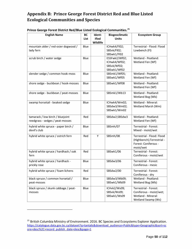
Page 50 of 112
Appendix B: Prince George Forest District Red and Blue Listed
Ecological Communities and Species
Prince George Forest District Red/Blue Listed Ecological Communities.25
English Name BC List
Ident-ified
Wildlife
Biogeoclimatic Units
Ecosystem Group
mountain alder / red-osier dogwood / lady fern
Blue ICHwk4/Fl02; SBSvk/Fl02; SBSwk1/Fl02
Terrestrial - Flood: Flood Lowbench (Fl)
scrub birch / water sedge Blue ESSFwk2/Wf02; ICHwk4/Wf02; SBSvk/Wf02; SBSwk1/Wf02
Wetland - Peatland: Wetland Fen (Wf)
slender sedge / common hook-moss Blue SBSmk1/Wf05; SBSwk1/Wf05
Wetland - Peatland: Wetland Fen (Wf)
shore sedge - buckbean / hook-mosses Blue SBSwk1/Wf08 Wetland - Peatland: Wetland Fen (Wf)
shore sedge - buckbean / peat-mosses Blue SBSmk1/Wb13 Wetland - Peatland: Wetland Bog (Wb)
swamp horsetail - beaked sedge Blue ICHwk4/Wm02; SBSdw3/Wm02; SBSwk1/Wm02
Wetland - Mineral: Wetland Marsh (Wm)
tamarack / low birch / bluejoint reedgrass - sedges / peat-mosses
Red SBSdw2;SBSdw3 Wetland - Peatland: Wetland Fen (Wf)
hybrid white spruce - paper birch / devil's club
Blue SBSmh/07 Terrestrial - Forest: Mixed - moist/wet
hybrid white spruce / ostrich fern Red Y SBSmh/08 Terrestrial - Flood: Flood (Highbench);Terrestrial - Forest: Coniferous - moist/wet
hybrid white spruce / hardhack / oak fern
Red SBSwk1/06 Terrestrial - Forest: Coniferous - moist/wet
hybrid white spruce / hardhack - prickly rose
Blue SBSdw3/06 Terrestrial - Forest: Coniferous - mesic
hybrid white spruce / foam lichens Red SBSdw2/00 Terrestrial - Forest: Coniferous - dry
black spruce / common horsetail / peat-mosses
Blue SBSdw3/Wb09; SBSwk1/Wb09
Wetland - Peatland: Wetland Bog (Wb)
black spruce / skunk cabbage / peat-mosses
Blue ICHvk2/Ws09; SBSvk/Ws09; SBSwk1/Ws09
Terrestrial - Forest: Coniferous - moist/wet; Wetland - Mineral: Wetland Swamp (Ws)
25 British Columbia Ministry of Environment. 2016. BC Species and Ecosystems Explorer Application. https://catalogue.data.gov.bc.ca/dataset?q=tantalis&download_audience=Public&type=Geographic&sort=score+desc%2C+record_publish_date+desc&page=1

Page 51 of 112
black spruce / buckbean / peat-mosses Blue ICHvk2/Wb11; SBSdw2/Wb11; SBSwk1/Wb11
Wetland - Peatland: Wetland Bog (Wb)
lodgepole pine - black spruce / red-stemmed feathermoss
Blue SBSdw2/07; SBSdw3/05
Terrestrial - Forest: Coniferous - mesic; Terrestrial - Forest: Coniferous - moist/wet
lodgepole pine / black huckleberry / reindeer lichens
Blue SBSvk/09; SBSwk1/02
Terrestrial - Forest: Coniferous - dry
lodgepole pine / black huckleberry - velvet-leaved blueberry
Blue SBSvk/02; SBSwk1/03
Terrestrial - Forest: Coniferous - dry
Sandberg's bluegrass - slender wheatgrass
Red SBSdw3 Terrestrial - Grassland: Grassland (Gg)
(balsam poplar, black cottonwood) - spruces / red-osier dogwood
Red ICHwk4/Fm02; SBSwk1/Fm02
Terrestrial - Flood: Flood Midbench (Fm);Terrestrial - Forest: Broadleaf - moist/wet
Douglas-fir / Douglas maple / step moss
Red SBSmh/04 Terrestrial - Forest: Coniferous - dry
Douglas-fir - hybrid white spruce / knight's plume
Blue SBSmk1/04; SBSwk1/04
Terrestrial - Forest: Coniferous - dry
Douglas-fir - hybrid white spruce / electrified cat's-tail moss
Blue SBSdw2/05 Terrestrial - Forest: Coniferous - dry
Douglas-fir - hybrid white spruce / thimbleberry
Blue SBSmh/01; SBSmh/05; SBSmh/06; SBSvk/03
Terrestrial - Forest: Coniferous - dry; Terrestrial - Forest: Coniferous - mesic
Douglas-fir - lodgepole pine / clad lichens
Blue SBSdw2/02; SBSdw3/02; SBSmh/02; SBSmh/03
Terrestrial - Forest: Coniferous - dry
Drummond's willow / bluejoint reedgrass
Blue SBSdw3/Fl05 Terrestrial - Flood: Flood Lowbench (Fl)
Sitka willow / Sitka sedge Blue SBSvk/Ws06; SBSwk1/Ws06
Wetland - Mineral: Wetland Swamp (Ws)
scheuchzeria / peat-mosses Blue SBSdw3/Wb12; SBSvk/Wb12
Wetland - Peatland: Wetland Bog (Wb)
western redcedar / devil's club / ostrich fern
Red Y ICHvk2/05 Terrestrial - Flood: Flood (Highbench);Terrestrial - Forest: Coniferous - moist/wet
western redcedar / falsebox Blue ICHwk4/03 Terrestrial - Forest: Coniferous - dry; Terrestrial - Forest: Coniferous - mesic
tufted clubrush / golden star-moss Blue SBSwk1/Wf11 Wetland - Peatland: Wetland Fen (Wf)
western hemlock - western redcedar / clad lichens
Blue ICHvk2/02; ICHwk4/02
Terrestrial - Forest: Coniferous - dry
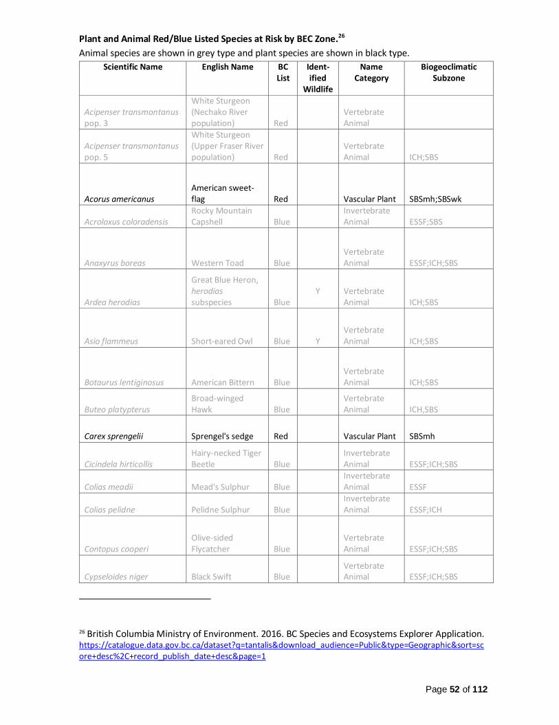
Page 52 of 112
Plant and Animal Red/Blue Listed Species at Risk by BEC Zone.26
Animal species are shown in grey type and plant species are shown in black type.
Scientific Name English Name BC List
Ident-ified
Wildlife
Name Category
Biogeoclimatic Subzone
Acipenser transmontanus pop. 3
White Sturgeon (Nechako River population) Red
Vertebrate Animal
Acipenser transmontanus pop. 5
White Sturgeon (Upper Fraser River population) Red
Vertebrate Animal ICH;SBS
Acorus americanus American sweet-flag Red Vascular Plant SBSmh;SBSwk
Acroloxus coloradensis Rocky Mountain Capshell Blue
Invertebrate Animal ESSF;SBS
Anaxyrus boreas Western Toad Blue Vertebrate Animal ESSF;ICH;SBS
Ardea herodias
Great Blue Heron, herodias subspecies Blue
Y
Vertebrate Animal ICH;SBS
Asio flammeus Short-eared Owl Blue Y Vertebrate Animal ICH;SBS
Botaurus lentiginosus American Bittern Blue Vertebrate Animal ICH;SBS
Buteo platypterus Broad-winged Hawk Blue
Vertebrate Animal ICH,SBS
Carex sprengelii Sprengel's sedge Red Vascular Plant SBSmh
Cicindela hirticollis Hairy-necked Tiger Beetle Blue
Invertebrate Animal ESSF;ICH;SBS
Colias meadii Mead's Sulphur Blue Invertebrate Animal ESSF
Colias pelidne Pelidne Sulphur Blue Invertebrate Animal ESSF;ICH
Contopus cooperi Olive-sided Flycatcher Blue
Vertebrate Animal ESSF;ICH;SBS
Cypseloides niger Black Swift Blue Vertebrate Animal ESSF;ICH;SBS
26 British Columbia Ministry of Environment. 2016. BC Species and Ecosystems Explorer Application. https://catalogue.data.gov.bc.ca/dataset?q=tantalis&download_audience=Public&type=Geographic&sort=score+desc%2C+record_publish_date+desc&page=1

Page 53 of 112
Dolichonyx oryzivorus Bobolink Blue Vertebrate Animal ICH;SBS
Draba fladnizensis Austrian draba Blue Vascular Plant SBSmk
Dryopteris cristata crested wood fern Blue Vascular Plant ICHvk;ICHwk;SBSmk
Epilobium halleanum Hall's willowherb Blue Vascular Plant ICHwk;SBSwk
Euphagus carolinus Rusty Blackbird Blue Vertebrate Animal ESSF;SBS
Galba parva Pygmy Fossaria Blue Invertebrate Animal SBS
Gulo luscus Wolverine, luscus subspecies Blue Y
Vertebrate Animal ESSF;ICH;SBS
Hirundo rustica Barn Swallow Blue Vertebrate Animal
ESSF;ICH;SBS
Malaxis brachypoda white adder's-mouth orchid Blue Vascular Plant SBSvk
Malaxis paludosa bog adder's-mouth orchid Blue Vascular Plant SBSdw;SBSwk
Meesia longiseta Blue Nonvascular Plant ESSF;SBS
Megalodonta beckii water marigold Blue Vascular Plant SBSmk
Myotis septentrionalis Northern Myotis Blue Vertebrate Animal ICH;SBS
Myrinia pulvinata Red Nonvascular Plant SBSmh
Nephroma occultum cryptic paw Blue Fungus ICH
Numenius americanus Long-billed Curlew Blue Y Vertebrate Animal ICH;SBS
Nymphaea tetragona pygmy waterlily Red Vascular Plant SBSmk; SBSwk
Oeneis jutta chermocki
Jutta Arctic, chermocki subspecies Blue
Invertebrate Animal ESSF;ICH;SBS
Oxytropis campestris var. davisii Davis' locoweed Blue Vascular Plant SBSmh
Pedicularis parviflora ssp. parviflora
small-flowered lousewort Red Vascular Plant
ICHwk;SBSmh;SBSmk;SBSwk

Page 54 of 112
Pekania pennanti Fisher Blue Y Vertebrate Animal ESSF;ICH;SBS
Pelecanus erythrorhynchos
American White Pelican Red Y
Vertebrate Animal ICH;SBS
Physella propinqua Rocky Mountain Physa Blue
Invertebrate Animal ESSF;SBS
Physella virginea Sunset Physa Blue Invertebrate Animal ESSF;ICH;SBS
Planorbula campestris Meadow Rams-horn Blue
Invertebrate Animal ESSF;ICH;SBS
Podiceps nigricollis Eared Grebe Blue Vertebrate Animal ESSF;ICH;SBS
Pohlia elongata Blue Nonvascular Plant ESSF;ICH
Pyrola elliptica shinleaf wintergreen Blue Vascular Plant SBSdw;SBSmh
Rangifer tarandus
Caribou (southern mountain population) Red Y
Vertebrate Animal ESSF;ICH
Rangifer tarandus
Caribou (northern mountain population) Blue Y
Vertebrate Animal ESSF;SBS
Rhodobryum roseum Blue Nonvascular Plant ICHwk;SBSwk
Salvelinus confluentus Bull Trout Blue Y Vertebrate Animal ESSF;ICH;SBS
Somatochlora brevicincta Quebec Emerald Blue Invertebrate Animal ESSF;ICH
Somatochlora forcipata Forcipate Emerald Blue Invertebrate Animal ESSF; SBS
Sparganium fluctuans water bur-reed Blue Vascular Plant SBSmk
Sphaerium striatinum Striated Fingernailclam Blue
Invertebrate Animal ESSF;ICH;SBS
Sphagnum wulfianum Blue Nonvascular Plant ICH;SBS
Taraxia breviflora short-flowered evening-primrose Red Vascular Plant SBSmk
Torreyochloa pallida Fernald's false manna Red Vascular Plant ICHwk

Page 55 of 112
Tympanuchus phasianellus columbianus
Sharp-tailed Grouse, columbianus subspecies Blue Y
Vertebrate Animal SBS
Ursus arctos Grizzly Bear Blue Y Vertebrate Animal ESSF;ICH;SBS

Page 56 of 112
Appendix C: Additional Riparian Management Requirements under
the Forest Planning and Practices Regulation In addition to those items provided under “Riparian and Water Quality Management” section, these are further legal requirements under the Forest Planning and Practices Regulation that are applicable to the Research Forest: Restrictions within Riparian Reserves
None of the following may be carried out in a riparian reserve zone: 1) grazing or broadcast herbicide applications for the purpose of brushing; 2) mechanized site preparation or broadcast burning for the purpose of site preparation; 3) spacing or thinning; 4) cut, modify or remove trees, except for the following purposes:
a) felling or modifying a tree that is a safety hazard, if there is no other practicable option for addressing the safety hazard;
b) topping or pruning a tree that is not wind firm; c) constructing a stream crossing; d) creating a corridor for full suspension yarding; e) creating guyline tiebacks; f) carrying out a sanitation treatment. This does not include clearcut harvesting for bark
beetles; g) felling or modifying a tree that has been windthrown or has been damaged by fire,
insects, disease or other causes, if the felling or modifying will not have a material adverse impact on the riparian reserve zone. This does not include clearcut harvesting for bark beetles;
h) felling or modifying a tree for the purpose of establishing or maintaining an interpretive forest site, recreation site, recreation facility or recreation trail.27
27 Ministry of Forests, Lands and Natural Resource Operations, 2016. Statutes and Regulations Webpages. http://www.bclaws.ca/Recon/document/ID/freeside/14_2004

Page 57 of 112
Appendix D: Preliminary Stream and Watershed Study The stream basins of interest that are discussed below are identified in Figures D-1, D-2, and D-3. Maps of the watersheds that are described below are provided in Figures D-4, D-5, and D-6 Unit A – Weedon Creek and Kerry Lake-Crooked River Watersheds Watershed Description The east side of Unit A drains west towards Kerry Lake and the Crooked River via three primary streams and the west side drains west via one stream that drains into a large stream network that flows northward into Weedon Creek. Unit A occupies the following areas within 3 distinct watersheds:
1) Less than 3% of the lands that drain directly into the Kerry Lake portion of the Crooked River. The interim Stream Flow Hazard Score is very low and the interim Sediment Hazard Score is very low.
2) Approximately 3% of the lands that drain directly into the Crooked River via an unnamed 4th order stream that enters the Crooked River upstream of Kerry Lake. The interim Stream Flow Hazard Score is low and the interim Sediment Hazard Score is moderate.
3) Less than 7% of the lands that drain into a large unnamed 5th order stream that flows northward into Weedon Creek. The interim Stream Flow Hazard Score is high and the interim Sediment Hazard Score is high.
Expected Watershed Impacts Unit A has little area influence within any of the identified watersheds, and a moderate level of harvest is expected within the next 5 years. Due to previous, notable watershed impacts from Unit A operations are not expected. Unit B – Tacheeda Lakes and Horseshoe Lake Watersheds Watershed Description Most of Unit B drains west directly into Tacheeda Lakes via seven stream pathways. The southeast portion of the unit drains towards Horseshoe Lake, which lies to the south and which ultimately drains in Tacheeda Lakes. Unit B occupies the following areas within 2 distinct watersheds:
1) Approximately 14% of the lands that drain directly into Tacheeda Lakes. The interim Stream Flow Hazard Score is very low and the interim Sediment Hazard Score is very low.
2) Approximately 7% the lands that drain into Horseshoe Lake, which is a 4th order watershed that drains into Tacheeda Lakes. The interim Stream Flow Hazard Score is low and the interim Sediment Hazard Score is very low.
Expected Watershed Impacts Unit B does have a notable influence on the watershed area that drains directly into Tacheeda Lakes, however the rate of harvest is largely controlled by visual quality objectives, which limits the amount of area that may be under recent harvest to a small percentage of the landscape. Due to the visual quality limitations, and the coinciding moderate level of harvest within the next 5 years, notable watershed impacts from Unit B operations are not expected.

Page 58 of 112
Unit C – Caine Creek and Merton Creek Watersheds The eastern side of Unit C drains via two streams that feed a larger stream network that flows to the northeast into Caine Creek. The western side of Unit C drains towards the Merton Creek system. Unit C occupies the following areas within five distinct watersheds:
1) Approximately 10% of the lands of a 4th order stream network that drains directly into the lower portion of Caine Creek. The interim Stream Flow Hazard Score is high and the interim Sediment Hazard Score is high.
2) Approximately 3% of the lands that drain directly into Caine Creek via small order streams. Caine Creek is a 5th order stream in the mid-lower part of the drainage basin. The interim Stream Flow Hazard Score is moderate and the interim Sediment Hazard Score is low.
3) Less than 3% of the lands that drain into Merton Creek upstream of Merton Lake (Merton Creek headwaters). Merton Creek is a 4th order stream. The interim Stream Flow Hazard Score is moderate and the interim Sediment Hazard Score is moderate.
4) Less than 6% of the lands that drain directly into Merton Lake or Merton Creek near the outlet of Merton Lake. The interim Stream Flow Hazard Score is moderate and the interim Sediment Hazard Score is moderate
5) Less than 1% of the lands that drain into a 3rd order stream that flows into Merton Creek. Due to minimal influence on this watershed the interim hazard scoring is considered immaterial.
Expected Watershed Impacts Unit C does have a notable influence on the area of the 4th order watershed that drains directly into the lower portion of Caine Creek. This watershed has high interim hazard scoring for both Stream Flow Hazard and Sediment Hazard. Due to widespread spruce beetle attack, a high harvest level is expected within the next five years. Accordingly, operations within Unit C, in combination with future beetle mortality and existing land modifications, may have the potential to negatively impact downstream conditions within the 4th order watershed and within the lower Caine Creek watershed.
Unit D – Caine Creek Watershed
The northern side of Unit D drains via one primary stream that feeds the upper portion of Caine Creek. The southern side of Unit D drains towards a stream network that feeds the headwaters of Caine Creek. Unit D occupies the following areas within three distinct watersheds:
1) Approximately 16% of the lands that form the headwaters of Caine Creek, which is a 3rd order stream within the upper part of the drainage basin. The interim Stream Flow Hazard Score is high and the interim Sediment Hazard Score is moderate.
2) A negligible amount of lands that drain into a 4th Order stream network that drains directly into the lower portion of Caine Creek. Due to minimal influence on this watershed the interim hazard scoring is considered immaterial.
3) Approximately 9% of the lands that drain directly into Caine Creek via small order streams. Unit C also occupies less 3% of this same watershed. Caine Creek is a 5th order stream in the mid-lower part of the drainage basin. The interim Stream Flow Hazard Score is moderate and the interim Sediment Hazard Score is low. It is also important to recognize that Unit D along with a small portion of Unit C occupy nearly all the mid to upper lands which drain into the stream identified in Figure D-1.
Page 59 of 112
Expected Watershed Impacts Unit D does have a notable influence on the area of the 3rd order watershed that forms the headwaters of Caine Creek. This watershed has high interim hazard scoring for Stream Flow Hazard. Due to widespread spruce beetle attack, a high harvest level is expected within the next five years. Accordingly, operations within Unit D, in combination with future beetle mortality and existing land modifications, may have the potential to negatively impact downstream conditions within the 3rd order watershed and within the lower Caine Creek watershed. When considering individual small order stream networks, there is also potential for negative impacts to the 2nd order stream within Unit D that flows into the Caine Creek headwaters.
Unit E – Chuchinka Creek Watershed The northern part of Unit E drains to the north into the northern branch of Chuchinka Creek while the southern part drains southward into the southern branch of Chuchinka Creek. Unit E occupies the following areas within two distinct watersheds:
1) Approximately 10% of the lands that drain directly into the northern branch of Chuchinka Creek, which is a 5th order stream in the lower-mid section of the northern drainage basin. The interim Stream Flow Hazard Score is very low and the interim Sediment Hazard Score is very low.
2) Approximately 9% of the lands that drain directly into the mid and lower section of the southern branch of Chuchinka Creek, which is a 6th order stream. Combined with Unit F, the Research Forest occupies approximately 23% of this watershed, therefore the combined influence of both units must be considered. The interim Stream Flow Hazard Score is low and the interim Sediment Hazard Score is low.
Unit E does have a notable influence on the area of the watersheds over which it lies, but considering the expected harvest level and current condition of the watersheds, notable watershed impacts from Unit E operations are not expected. Unit F – Chuchinka Creek and Angusmac Creek Watersheds The northern majority of Unit F drains into the southern branch of Chuchinka creek via three separate stream networks. The southern portion of Unit F drains via one primary stream pathway into Angusmac Creek. Unit F occupies the following areas within two distinct watersheds:
1) Approximately 14% of the lands that drain directly into the mid and lower section of the southern branch of Chuchinka Creek, which is a 6th order stream. Combined with Unit E, the Research Forest occupies approximately 23% of this watershed, therefore the combined influence of both units must be considered. The interim Stream Flow Hazard Score is low and the interim Sediment Hazard Score is low.
2) Approximately 6% of the lands that drain directly into the mid and lower section of Angusmac Creek which is a 4th order stream prior to its confluence with Chuchinka Creek. The interim Stream Flow Hazard Score is low and the interim Sediment Hazard Score is low.
Unit F, in combination with Unit E, does have a notable influence on the watershed that encompasses the lower section of the southern branch of Chuchinka Creek, but considering the expected harvest level and current condition of the watersheds, notable watershed impacts from Unit F operations are not expected.

Page 60 of 112
Unit G - Angusmac Creek and Crooked River Watershed The western quarter of Unit G drains via two streams into a large unnamed stream network that flows north into the Crooked River. The majority of Unit G drains via the internal Lakes and wetland system into the mid portion of Angusmac Creek. Unit G occupies the following areas within four distinct watersheds:
1) Approximately 21% of the lands that drain directly into the mid-section of Angusmac Creek, which is 4th order stream. The interim Stream Flow Hazard Score is low and the interim Sediment Hazard Score is very low.
2) Less than 1% of the lands that drain directly into the mid and lower section of Angusmac Creek which is a 4th order stream prior to its confluence with Chuchinka Creek. Due to the minimal influence on this watershed the interim hazard scoring is considered immaterial.
3) Approximately 8% of the lands that drain directly into a large unnamed 4th order stream system that flows northward into the Crooked River. The interim Stream Flow Hazard Score is low and the interim Sediment Hazard Score is low
4) Approximately 2% of the lands that drain into a large 4th order stream system that ultimately drains into the Crooked River. Due to the minimal influence on this watershed the interim hazard scoring is considered immaterial.
Unit G does have a notable influence on the area of lands that drain directly into the mid-section of Angusmac Creek; however only a moderate level of harvest is expected in that watershed area. As such, notable watershed impacts from Unit G operations are not expected. Unit H – Bowron River Watershed The western majority of Unit H drains into two primary streams that flow directly into the Bowron River. The eastern end of Unit H drains to the east into a separate watershed that drains north towards the Bowron River. Unit H occupies the following areas within two distinct watersheds:
1) Approximately 6% of the lands that drain directly into the lower Bowron River via small order streams. The interim Stream Flow Hazard Score is very low and the interim Sediment Hazard Score is very low.
2) Approximately 3% of the lands that drain directly into a large, unnamed 3rd order stream system that drains northward into the lower Bowron River. The interim Stream Flow Hazard Score is very low and the interim Sediment Hazard Score is very low.
Unit H does not have a notable influence on the area of the watersheds, over which it lies, and a low to moderate harvest level is expected. Therefore, notable watershed impacts from Unit H operations are not expected. Unit I – Hungary Creek and Fraser River Watersheds The southeast corner of Unit I drains into one stream that flows directly into the Fraser River. The rest of Unit I drains via two streams into Hungary Creek. Unit I occupies the following areas within two distinct watersheds:
1) Approximately 7% of the lands that drain directly into the south side of the Fraser River from small order streams. The interim Stream Flow Hazard Score is low and the interim Sediment Hazard Score is high.
2) Approximately 7% of the lands that drain directly into Hungary creek via small order streams. The lower section of Hungary Creek is a 4th order stream. The interim Stream

Page 61 of 112
Flow Hazard Score is low and the interim Sediment Hazard Score is moderate. It is also important to recognize that Unit I occupies nearly all the land that drains into the stream, identified in Figure D-2. This stream is a direct tributary to Hungary Creek.
Unit I does not have a notable influence on the area of the watersheds, over which it lies. Depending of future harvest patterns within Unit I, there is the potential to have a notable influence on the conditions within the drainage basin of the aforementioned 2nd order stream; however, a low to moderate harvest level is expected within Unit I and within the 2nd order drainage basin, therefore notable watershed impacts from Unit I operations are not expected. Unit J - Fraser River Watershed Except for the southern end of Unit J, all of the unit drains into one mapped stream tributary that flows along the north edge of Unit J and directly into the Fraser River across from Naver Creek. The southern end drains into Porter Creek, which flows directly into the Fraser River, across from Naver Creek. Unit J occupies the following areas within two distinct watersheds:
1) Approximately 27% of the lands that drain directly into the unnamed, 4th order stream that flows along the boundaries of unit J directly into the Fraser River. The interim Stream Flow Hazard Score is low and the interim Sediment Hazard Score is moderate.
2) Approximately 12% of the lands that drain directly into the west side of the Fraser River from small order streams. The interim Stream Flow Hazard Score is low and the interim Sediment Hazard Score is very high. It is also important to recognize that Unit J contains virtually all the land that drains into Porter Creek, which is identified in Figure D-3.
Unit J does have a notable influence on the area of the watersheds over which it lies. Depending of future harvest patterns within Unit J, there is also the potential to have a notable influence on the conditions within the Porter Creek drainage basin (2nd order basin), however a low to moderate harvest level is expected within Unit J and within the Porter Creek drainage basin, therefore notable watershed impacts from Unit J operations are not expected. Unit K – Pitoney Creek and Willow River Watersheds
The eastern side of Unit K drains via two streams into Pitoney Creek. The western part of Unit K drains via two streams directly into the Willow River. Unit K occupies the following areas within two distinct watersheds:
1) Approximately 2% of the lands that drain directly into the east side of the Willow River from small order streams. Combined with Unit L, the total area occupied is approximately 4% of this watershed. The interim Stream Flow Hazard Score is high and the interim Sediment Hazard Score is moderate.
2) Approximately 6% of all the lands that drain into Pitoney Creek, which is a 5th order stream at its confluence with the Willow River. The interim Stream Flow Hazard Score is low and the interim Sediment Hazard Score is very low.
Unit K does not have a notable influence on the area of the watersheds, over which it lies, furthermore harvesting within 1/3 of Unit K is restricted by a retention visual quality objective. In consideration of the overall, low level of harvesting and the small area influence, notable watershed impacts from Unit K operations are not expected.

Page 62 of 112
Unit L – Willow River Watershed
Unit L has limited terrain and only one principle stream, which flows to the northwest and drains directly into the Willow River. Unit L occupies the following areas within one distinct watershed:
1) Approximately 2% of the lands that drain directly into the east side of the Willow River from small order streams. Combined with Unit K, the total area occupied is approximately 4% of this watershed. The interim Stream Flow Hazard Score is high and the interim Sediment Hazard Score is moderate.
Unit L does not have a notable influence on the area of the watershed, over which it lies, and a low to moderate harvest level is expected. Therefore, notable watershed impacts from Unit L operations are not expected. The following maps identify the stream basins that are largely contained with the Research Forest area, and may be highly influenced by the level of harvesting and road building undertaken. Figure D-1: Map of Stream Basin of Interest within Research Forest Unit D28
28 GeoBC, Province of British Columbia. 2016. Freshwater Atlas Dataset. http://geobc.gov.bc.ca/base-mapping/atlas/fwa/fwa_data.html

Page 63 of 112
Figure D-2: Map of Stream Basin of Interest within Research Forest Unit I29
29 GeoBC, Province of British Columbia. 2016. Freshwater Atlas Dataset. http://geobc.gov.bc.ca/base-mapping/atlas/fwa/fwa_data.html

Page 64 of 112
Figure D-3: Map of Stream Basin of Interest within Research Forest Unit J30
The following three maps show the interim hazard rating for Stream Flow (Peak Flow), Sediment (Surface Erosion), and Riparian conditions within the watersheds, over which the Research Forest is situated. These hazards were calculated by the Omineca Region of the Ministry of Forests, Lands and Natural Resources.31
30 GeoBC, Province of British Columbia. 2016. Freshwater Atlas Dataset. http://geobc.gov.bc.ca/base-mapping/atlas/fwa/fwa_data.html 31 Ministry of Forests, Lands and Natural Resource Operations, Omineca Regional Office. 2016. Interim Watershed Hazard Ratings for the Omineca Natural Resource Region.

Page 65 of 112
Figure D-4: Interim Stream (Peak) Flow Hazard Rating for Watersheds within Research Forest

Page 66 of 112
Figure D-5: Interim Sediment (Surface Erosion) Hazard Rating for Watersheds within Research Forest

Page 67 of 112
Figure D-6: Interim Riparian Hazard Rating for Watersheds within Research Forest

Page 68 of 112
Appendix E: Visual Quality Objectives: Definition of altered forest
landscape under The Forest Planning and Practices Regulation
"altered forest landscape" means forest landscape that (a) is viewable from a significant public viewpoint, (b) contains cutblocks or roads, and (c) is in one of the categories prescribed under section 1.1;
1.1) For the purposes of paragraph (c) of the definition of "altered forest landscape" in section 1, the
following categories are prescribed, each according to the extent of alteration resulting from the size, shape and location of cutblocks and roads: (a) preservation: consisting of an altered forest landscape in which the alteration, when
assessed from a significant public viewpoint, is (i) very small in scale, and (ii) not easily distinguishable from the pre-harvest landscape;
(b) retention: consisting of an altered forest landscape in which the alteration, when assessed from a significant public viewpoint, is (i) difficult to see, (ii) small in scale, and (iii) natural in appearance;
(c) partial retention: consisting of an altered forest landscape in which the alteration, when assessed from a significant public viewpoint, is (i) easy to see, (ii) small to medium in scale, and (iii) natural and not rectilinear or geometric in shape;
(d) modification: consisting of an altered forest landscape in which the alteration, when assessed from a significant public viewpoint, (i) is very easy to see, and (ii) is (A) large in scale and natural in its appearance, or (B) small to medium in scale but with
some angular characteristics; (e) maximum modification: consisting of an altered forest landscape in which the alteration,
when assessed from a significant public viewpoint, (i) is very easy to see, and (ii) is (A) very large in scale, (B) rectilinear and geometric in shape, or (C) both.32
32 Ministry of Forests, Lands and Natural Resource Operations, 2016. Statutes and Regulations Webpages. http://www.bclaws.ca/Recon/document/ID/freeside/14_2004
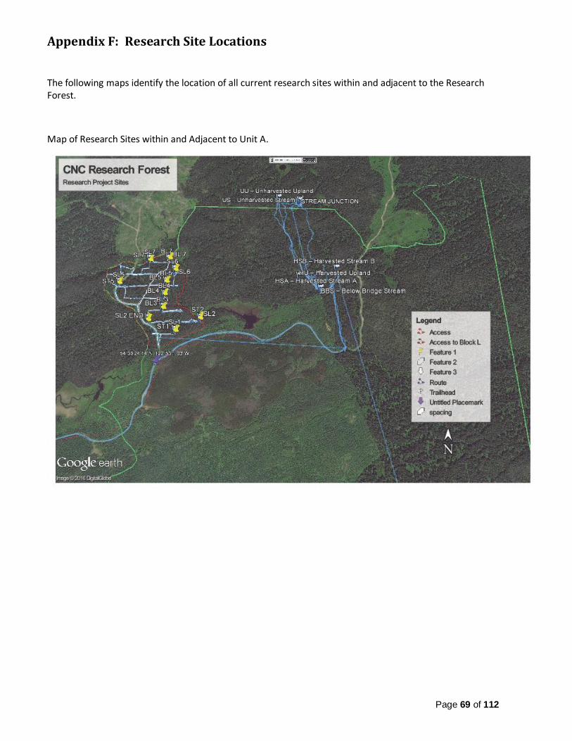
Page 69 of 112
Appendix F: Research Site Locations The following maps identify the location of all current research sites within and adjacent to the Research Forest.
Map of Research Sites within and Adjacent to Unit A.

Page 70 of 112
Map of Research Sites within and Adjacent to Unit D.

Page 71 of 112
Map of Research Sites within and Adjacent to Unit E.
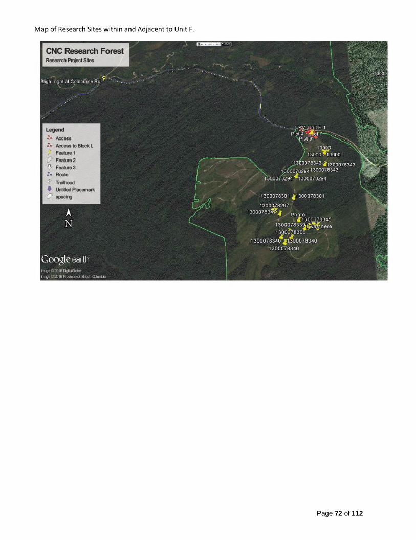
Page 72 of 112
Map of Research Sites within and Adjacent to Unit F.
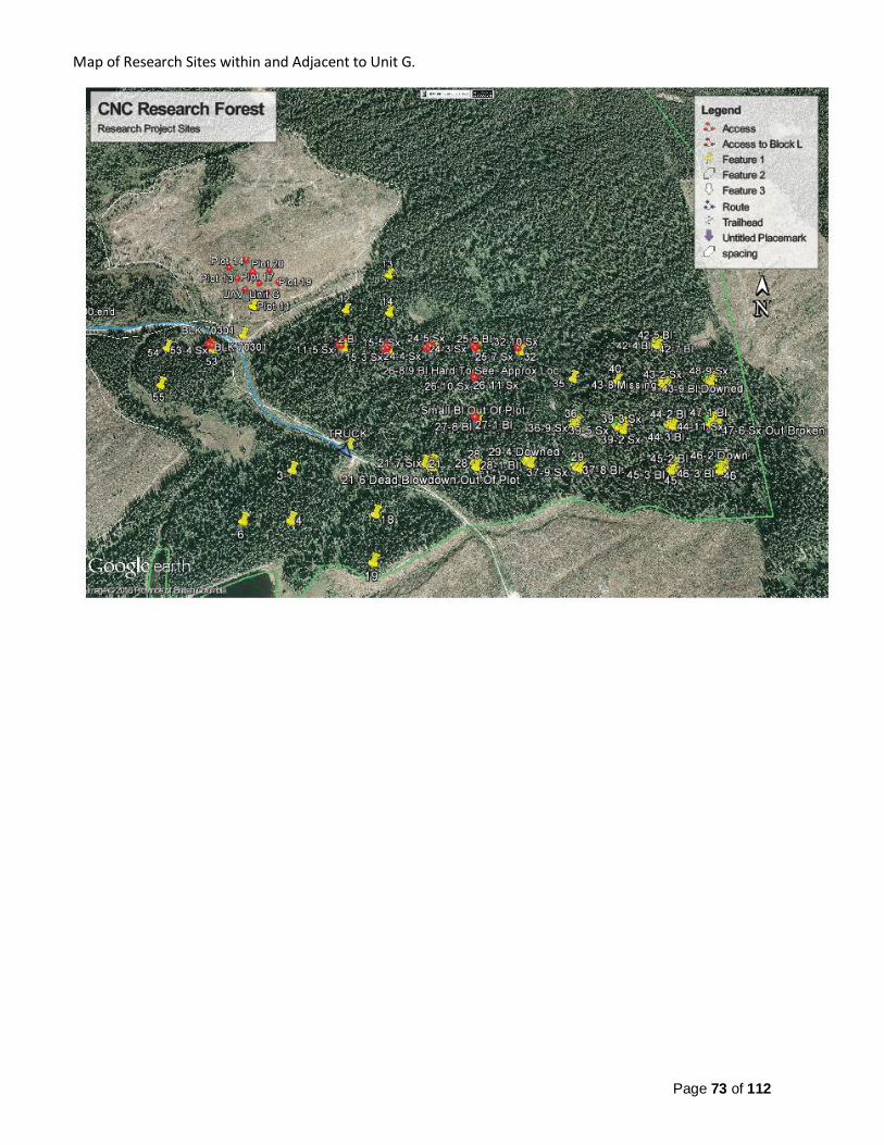
Page 73 of 112
Map of Research Sites within and Adjacent to Unit G.

Page 74 of 112
Map of Research Sites within and Adjacent to Unit G.

Page 75 of 112
Map of Research Sites within and Adjacent to Unit H.

Page 76 of 112
Map of Research Sites within and Adjacent to Unit J.

Page 77 of 112
Map of Research Sites within and Adjacent to Unit K.

Page 78 of 112
Map of Research Sites within and Adjacent to Unit L.
Summary of Research Site Locations within and Adjacent to the Research Forest.
CNC Research
Forest Unit
General Location
Description
Direction from
Prince George
Research Category
Summarized Project Title
Project Description
Location Active, Inactive,
Complete? UTM Zone
Easting Northing
A-1 Bear Lake North-West
Forest Operations
Riparian UU –
Unharvested Upland
10 U 508348.
3 6058038
.2 Active
A-1 Bear Lake North-West
Forest Operations
Riparian US –
Unharvested Stream
10 U 508521.
83 6058011
.8 Active
A-1 Bear Lake North-West
Forest Operations
Riparian HU –
Harvested Upland
10 U 508521.
38 6057293
.3 Active
A-1 Bear Lake North-West
Forest Operations
Riparian HSA –
Harvested Stream A
10 U 508667.
32 6057309
.1 Active

Page 79 of 112
A-1 Bear Lake North-West
Forest Operations
Riparian HSB –
Harvested Stream B
10 U 508808.
93 6057363
.1 Active
A-1 Bear Lake North-West
Forest Operations
Riparian
BBS – Below Bridge Stream
10 U 508683.
88 6057186
.4 Active
A-1 Bear Lake North-West
Forest Operations
Stub Tree Transects 10 U 507446.
79 6057029
.7 Active
D Bear Lake North Silviculture
Provincial Research
Trial: E.P.886.13,
Installation 9 – Hand Lake
Fertilizer Trial, 3
replications of 6
treatments: NB,
NSB, ON1, ONM2,
Complete & Control
10U 506986 6027572 Unknown
E-1 Bear Lake North-
East
Silviculture & Climate
Change
Microclimate Measurement
Climate data for assisted
migration
10 U 533586 6042328 Active
E-1 Bear Lake North-
East
Silviculture & Climate
Change
Assisted Migration:
Influence of Aspect
BLN Seedling
Trial: North Aspect
10 U 533655 6042443 Active,
msmts in ~2021
E-1 Bear Lake North-
East
Silviculture & Climate
Change
Assisted Migration:
Influence of Aspect
BLS Seedling
Trial: South Aspect
10 U 533612 6042305 Active,
msmts in ~2021
E-1 Bear Lake North-
East
Silviculture & Climate
Change
Assisted Migration:
Soil Moisture Limitations
Seedling Trial:
Sub-Mesic 10 U
533537.78
6042275.1
Active
E-1 Bear Lake North-
East
Silviculture & Climate
Change
Assisted Migration:
Soil Moisture Limitations
Seedling Trial: Mesic
10 U 533470.
44 6042236
.1 Active
E-1 Bear Lake North-
East
Silviculture & Climate
Change
Assisted Migration:
Soil Moisture Limitations
Seedling Trial: Sub-
Hygric
10 U 533552.
1 6042475
.5 Active

Page 80 of 112
E-1 Bear Lake North Silviculture & Climate
Change Frost Project
2012=16 Sensors 203=10 Sensors
10U 533443.
84 6042641
.54 Complete
F-1 Bear Lake North-
East Geomatics
UAV Applications in Forestry:
Larry McCulloch
CNC: Unit F
10 U 531153.
42 6041249
.2 Complete
F-1 Bear Lake North Silviculture & Climate
Change Frost Project
2013=10 Sensors
10U 530721.
7 6039930
.4 Complete
G-2 Bear Lake North-
East Geomatics
UAV/ Photogramm
etry: JR CanMap
Unit G Stem
Mapping 10 U
534996.24
6029029.7
Active
G Bear Lake North-
East Geomatics
UAV Applications in Forestry:
Larry McCulloch
CNC: Unit G
10 U 534675.
25 6029462
.9 Complete
H Beaver FSR
(Mount Bowron)
East Silviculture & Climate
Change
Oak Fern Transects
OF5: North Aspect
10 U 559232 5979345 Active
H Beaver FSR
(Mount Bowron)
East Silviculture & Climate
Change
Oak Fern Transects
OF6: South Aspect
10 U 559179 5979378 Active
J
Blackwater Rd/
Woodpecker FSR
South Silviculture & Climate
Change
Oak Fern Transects
OF9: North Aspect
10 U 516119 5922166 Active
J
Blackwater Rd/
Woodpecker FSR
South Silviculture & Climate
Change
Oak Fern Transects
OF10: South Aspect
10 U 516150 5922285 Active
K
Willow-Cale/
Willow-100 FSR
South-East
Silviculture & Climate
Change
Assisted Migration White
Pine Trial
10 U 555576 5947761 Inactive
K Willow-Cale/
Willow-100 FSR
South-East
Forest Operations
Espacement Trial
1m x 1m Spacing
10 U 556151 5947550 Inactive
K Willow-Cale/
Willow-100 FSR
South-East
Forest Operations
Espacement Trial
2m x 2m Spacing
10 U 556155 5947588 Inactive
K Willow-Cale/
Willow-100 FSR
South-East
Forest Operations
Espacement Trial
3m x 3m Spacing
10 U 556153 5947625 Inactive
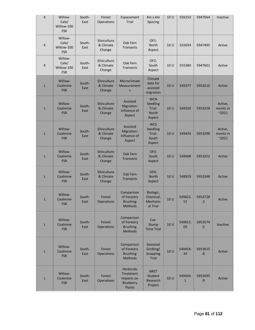
Page 81 of 112
K Willow-Cale/
Willow-100 FSR
South-East
Forest Operations
Espacement Trial
4m x 4m Spacing
10 U 556153 5947664 Inactive
K
Willow-Cale/
Willow-100 FSR
South-East
Silviculture & Climate
Change
Oak Fern Transects
OF1: North Aspect
10 U 555034 5947495 Active
K
Willow-Cale/
Willow-100 FSR
South-East
Silviculture & Climate
Change
Oak Fern Transects
OF2: South Aspect
10 U 555384 5947601 Active
L Willow-
Coalmine FSR
South-East
Silviculture & Climate
Change
Microclimate Measurement
s
Climate data for assisted
migration
10 U 549377 5953210 Active
L Willow-
Coalmine FSR
South-East
Silviculture & Climate
Change
Assisted Migration:
Influence of Aspect
WCN Seedling
Trial: North Aspect
10 U 549330 5953258 Active,
msmts in ~2021
L Willow-
Coalmine FSR
South-East
Silviculture & Climate
Change
Assisted Migration:
Influence of Aspect
WCS Seedling
Trial: South Aspect
10 U 549426 5953298 Active,
msmts in ~2021
L Willow-
Coalmine FSR
South-East
Silviculture & Climate
Change
Oak Fern Transects
OF3: South Aspect
10 U 549608 5953252 Active
L Willow-
Coalmine FSR
South-East
Silviculture & Climate
Change
Oak Fern Transects
OF4: North Aspect
10 U 548919 5953348 Active
L Willow-
Coalmine FSR
South-East
Forest Operations
Comparison of Forestry Brushing Methods
Biologic, Chemical, Mechanic
al Trial
10 U 549623.
52 5953728
.3 Active
L Willow-
Coalmine FSR
South-East
Forest Operations
Comparison of Forestry Brushing Methods
Cut-Stump
Time Trial 10 U
549613.05
5953574.5
Inactive
L Willow-
Coalmine FSR
South-East
Forest Operations
Comparison of Forestry Brushing Methods
Seasonal Girdling/ Snapping
Trial
10 U 549418.
34 5953615
.8 Active
L Willow-
Coalmine FSR
South-East
Forest Operations
Herbicide Treatment Impacts on Blueberry
Plants
NRET Student
Research Project
10 U 549439.
1 5953595
.9 Active

Page 82 of 112
L Willow-
Coalmine FSR
South-East
Geomatics
UAV/ Photogramm
etry: JR CanMap
Unit L Data
Collection 10 U
549312.1
5954007.2
Complete
L Willow-
Coalmine FSR
South-East
Geomatics
UAV Applications in Forestry:
Larry McCulloch
CNC: Unit L
10 U 549285 5953991
.1 Complete

Page 83 of 112
Appendix G: Management Plan Content Map Research Forest Management Plan Map - Unit A.
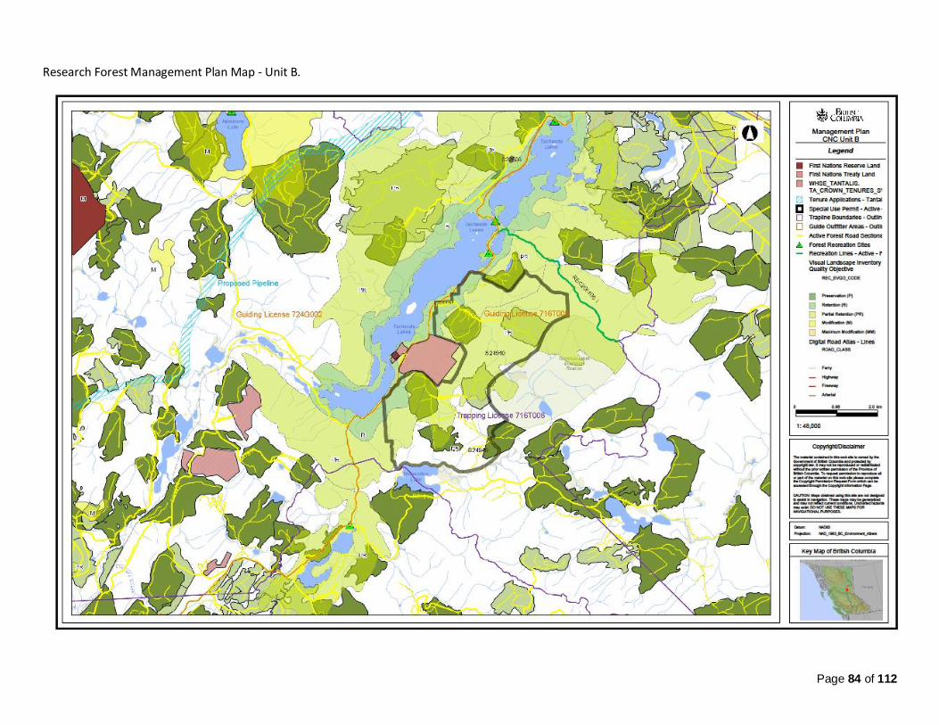
Page 84 of 112
Research Forest Management Plan Map - Unit B.

Page 85 of 112
Research Forest Management Plan Map - Unit C and D.

Page 86 of 112
Research Forest Management Plan Map - Unit E and F

Page 87 of 112
Research Forest Management Plan Map - Unit G.

Page 88 of 112
Research Forest Management Plan Map - Unit H.

Page 89 of 112
Research Forest Management Plan Map - Unit I.

Page 90 of 112
Research Forest Management Plan Map - Unit J.

Page 91 of 112
Research Forest Management Plan Map - Unit K and L.
Page 92 of 112
Appendix H: Timber Supply Analysis and Review
COLLEGE OF NEW CALEDONIA RESEARCH FOREST
2016 TIMBER SUPPLY ANALYSIS
Prepared for:
College of New Caledonia
Prepared by:
Industrial Forestry Service Ltd. 1595 Fifth Avenue
Prince George, B.C.
V2L 3L9 Tel: (250) 564 4115 Fax: (250) 563-9679
March 2016
Document Number:
V2c

March, 2016 Document Number
V2c
INDUSTRIAL FORESTRY SERVICE LTD.
ii
Prepared by Industrial Forestry Service Ltd.
March 2016
Lead Author: Robert Schuetz, Registered Professional Forester
Lead Review by: Carl Pollard, Registered Professional Forester
COLLEGE OF NEW CALEDONIA RESEARCH FOREST
2016 TIMBER SUPPLY ANALYSIS

2016 Timber Supply Analysis Appendix H: Timber Supply Analysis
and Review
March, 2016 Document Number
V2c
INDUSTRIAL FORESTRY SERVICE LTD.
iii
Contents
1 Introduction 2
2 Base Case Modelling Assumptions 3
2.1 Timber harvesting land base 3
2.2 Yield Tables 4
2.2.1 Spruce mortality 4
2.3 Roads 5
2.4 Biodiversity 5
2.5 Visual Quality 6
2.6 Minimum volume per hectare 6
2.7 Lifespan 6
2.8 Non Recoverable Losses 6
2.9 Harvest Priority 6
2.10 Model and Objective 6
3 Insect disturbance 7
4 Sensitivity Scenarios 9
5 Base Case Analysis Results 11
6 Sensitivity Scenario Results 2
List of Tables
Table 1 Timber Harvesting Land Base Net Down ............................................................................. 4
Table 2. Assumed spruce volume mortality ...................................................................................... 9
Table 3 Assumed Spruce Mortality................................................................................................. 10
Table 4 Application of the PG Old Growth Order in Sensitivity Scenarios 4 and 5 ........................... 11
Table 5. Sensitivity Analysis Harvest Flow Results ......................................................................... 42
List of Figures
Figure 1 Base Case Harvest Forecast ........................................................................................... 12

2016 Timber Supply Analysis Appendix H: Timber Supply Analysis
and Review
March, 2016 Document Number
V2c
INDUSTRIAL FORESTRY SERVICE LTD.
iv
Figure 2. Forecast Change in growing Stock .................................................................................. 13
Figure 4 Forecast Change in Average Harvest Age........................................................................ 13
Figure 3 Forecast Change in Age Class Distribution ...................................................................... 14
Figure 5 Forecast Change in Average Stand Volume Harvested ..................................................... 1
Figure 6 Forecast Transition from Unmanaged to Managed Stand Harvests .................................... 1
Figure 7 Forecast Area Harvested ................................................................................................... 2
Figure 8 Scenario 2 Harvest Flow vs Base Case .............................................................................. 3
Figure 9 Scenario 3 Harvest Flow versus Base Case ....................................................................... 3
Figure 10 Scenario 4 Harvest Flow versus Base Case ..................................................................... 4
Figure 11 Scenario 5 Harvest Flow versus Base Case ..................................................................... 4

2016 Timber Supply Analysis Introduction
March, 2016 Document Number
V2c
INDUSTRIAL FORESTRY SERVICE LTD.
2
1 Introduction
The following report describes a timber supply analysis completed for the College of New
Caledonia (CNC) Research Forest in 2016. The Research Forest’s location is shown in
Map 1. This report and associated analysis is an update to a previous analysis competed in
2013. Rationale for the analysis is to update management assumptions and considerations
required to address a rapidly emerging spruce beetle epidemic affecting parts of the CNC
Research Forest.
Map 1. Location of Research Forest
The majority of the timber supply modeling assumptions and data used in this new analysis
and described in this report has not changed since 2013. In brief, what has changed is noted
below.
The land base has been updated for disturbance history to October 2015. As a
result, the timber harvesting land base (THLB) has declined slightly through the
development of new roads.
The age class distribution has been changed slightly. Stands have been aged to
January 2016. Newly harvest areas have been reset to an age of 1 year. This
includes areas logged in 2015/2016 identified as A-1, E-1,2,3, F-1,2,3,4 and G1.
As before, the Remsoft Spatial Planning System (Woodstock) was used to
complete the timber supply analysis. However the planning periods have been

2016 Timber Supply Analysis Base Case Modelling Assumptions
March, 2016 Document Number
V2c
INDUSTRIAL FORESTRY SERVICE LTD.
3
changed from 10-year periods to 5-year periods to improve the resolution of
harvest impacts in the short term.
In this analysis we have assumed that the mountain pine beetle epidemic is over.
An estimated 164,500 cubic metres or 429 hectares of pine-leading THLB area
(i.e., defined as >70% pine volume and > 65 years old) exists in the Research
Forest. Total volume is approximately 164,430 cubic metres. Within this area, an
estimated 89 hectares containing 33,621 cubic metres is economically
salvageable. The remaining MPB-killed area is assumed to regenerate naturally
after a 10 year regeneration delay.
Modelling a spruce beetle epidemic is the major change to this analysis. Several
scenarios will test the impact of alternative salvage harvesting regimes on varying
levels of spruce beetle mortality.
The sections of this report that follow provide detail on the base case modelling assumptions,
the results of the analysis and the results of various scenarios.
2 Base Case Modelling Assumptions
This section of the report describes the base case modelling assumptions. For brevity this
report refers extensively to the 2013 timber supply analysis of the CNC Research Forest. A
copy of the 2013 analysis report is appended to this document.
2.1 Timber harvesting land base
No logic changes were applied to the THLB from the previous analysis. However, new road
construction (post 2012) was obtained and buffered. The new roads were removed from the
contributing forest land base. As a result, the revised THLB is 11,377 hectares (ha). This is
a reduction of 5 hectares from the 11,383 ha identified in 2012. The updated THLB net down
table for the Research Forest is shown in Table 1.

2016 Timber Supply Analysis Base Case Modelling Assumptions
March, 2016 Document Number
V2c
INDUSTRIAL FORESTRY SERVICE LTD.
4
Table 1 Timber Harvesting Land Base Net Down
Land Base Classification 2013
Area (ha)
2016
Area (ha)
Gross Area of CNCRF 12,581 12,580
Non-Forest & Non-Productive 149 149
Existing roads 169 174
Crown Forested Land Base (CFLB) 12,263 12,257
Physically Inoperable Areas 12 12
Problem Forest Types & Deciduous 654 654
Riparian Reserve Zones 214 214
Total Non-Contributing Land Base (NCLB) 880 880
Current Timber Harvesting Land Base (THLB) 11,383 11,377
2.2 Yield Tables
Yield tables have not changed from the previous analysis, with the exception of changing the
periods from 10-years to 5-years. As in the original analysis, unmanaged stand yield tables
were specific to each leading species, site productivity (i.e., very good, good, medium, poor,
very poor) and operating area.
Managed stand yield tables were specific to each leading species and site productivity and
did not differentiate between operating areas.
All yield tables were reduced by 12 percent to account for wildlife tree patches.
2.2.1 Spruce mortality
Significant volumes of mature spruce trees are at risk to being lost as a consequence of a
rapidly growing spruce beetle epidemic. Stands at risk are defined as leading spruce stands

2016 Timber Supply Analysis Base Case Modelling Assumptions
March, 2016 Document Number
V2c
INDUSTRIAL FORESTRY SERVICE LTD.
5
greater than 120 years of age. The scenarios modelled varying levels of mortality in old
spruce leading stands whereby stands assumed to be killed by spruce beetle mortality were
spatially identified. When the mortality in an operating unit was deemed to be some assigned
percent number (i.e., 50%) of the spruce volume, all leading spruce stands within the unit
that were greater than 120 years of age were identified along with the associated spruce
volume in each stand. Starting with the oldest stands first, mortality was assigned until 50%
of the volume was allocated to mortality. The assumed shelf-life of spruce beetle killed stands
was 1 period (5 years). If not harvested by the end of the period, they were assumed to
regenerate naturally after a 10 year delay.
2.2.2 Pine Mortality
The yield tables for stands affected by the MPB (>70% pine) were adjusted so that net volume
was 60 percent of the original green volume. This conforms to the current net-down
adjustments in timber cruising dead pine stands. Since these stands were largely killed in
2006-2010, a shelf life of 5 more years was assumed. If the MPB stands are not harvested
by 2020 they were assumed to regenerate naturally after a 10 year delay. The yield tables
for stands having between 50% and 70% pine were reduced to 70% of their original volume.
2.3 Roads
A reduction of area for existing roads was accomplished by buffering a specified distance
around all existing roads. Since 2012 new roads have been constructed within the Research
Forest. A 10 metre right of way was signed to these new roads (5 metres per side). The result
was a reduction of 6.3 hectares from the Crown Forest.
Future roads are modelled by converting 1.37% of all unmanaged stands, post-harvest into
the non-forest land base. This reduction was not applied to any stands having logging history.
2.4 Biodiversity
Stand level biodiversity is addressed via a 12 percent reduction to the yield tables.
Landscape level biodiversity is modelled such that 19 percent of the Crown forest had to be
maintained over 120 years of age. Sensitivity analysis assess the impact of the Prince
George TSA old growth order specific to merged BEC.

2016 Timber Supply Analysis Base Case Modelling Assumptions
March, 2016 Document Number
V2c
INDUSTRIAL FORESTRY SERVICE LTD.
6
2.5 Visual Quality
Visual Quality Objectives (VQOs) were modelled as per the previous analysis. Retention
VQO areas were restricted to a maximum of 2.432 percent less than 20 years; partial
retention VQOs were modelled to ensure no more than 14.66 percent of the area was less
than 20 years; modification VQOs were allowed no more than 38.3 percent less than 20 years
of age.
2.6 Minimum volume per hectare
Only stands that have a merchantable volume in the THLB greater than or equal to 140 cubic
metres per hectare and were also greater than 80 years of age were considered eligible for
harvesting. These constraints are applied to both unmanaged and managed stands.
2.7 Lifespan
This analysis assumed that stands could not age more than 350 years. After this time, if not
harvested, they were assumed to regenerate to an unmanaged stand.
2.8 Non Recoverable Losses
The previous analysis did not adjust for NRLs in unmanaged stands. The assumption being
that managed stands have OAFs and the units were well-roaded, allowing foresters to
respond quickly to disturbance and potential losses to volume.
2.9 Harvest Priority
The model will allow the linear program optimizer to select and prioritize stands in an order
that maximized the short, mid and long term harvest levels.
2.10 Model and Objective
The previous analysis used linear goal programming with the objective to maximize
harvesting subject to the constraints identified previously. The same objectives were
prescribed in this analysis.
Harvest flow objectives included:
4) Maximize salvage for the next 10 years.
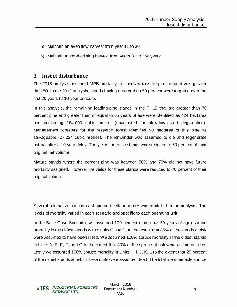
2016 Timber Supply Analysis Insect disturbance
March, 2016 Document Number
V2c
INDUSTRIAL FORESTRY SERVICE LTD.
7
5) Maintain an even flow harvest from year 11 to 30
6) Maintain a non-declining harvest from years 31 to 250 years
3 Insect disturbance
The 2013 analysis assumed MPB mortality in stands where the pine percent was greater
than 50. In the 2013 analysis, stands having greater than 50 percent were targeted over the
first 20 years (2 10-year periods).
In this analysis, the remaining leading-pine stands in the THLB that are greater than 70
percent pine and greater than or equal to 65 years of age were identified as 424 hectares
and containing 164,000 cubic meters (unadjusted for blowdown and degradation).
Management foresters for the research forest identified 90 hectares of this pine as
salvageable (27,224 cubic metres). The remainder was assumed to die and regenerate
natural after a 10-year delay. The yields for these stands were reduced to 60 percent of their
original net volume.
Mature stands where the percent pine was between 50% and 70% did not have future
mortality assigned. However the yields for these stands were reduced to 70 percent of their
original volume.
Several alternative scenarios of spruce beetle mortality was modelled in the analysis. The
levels of mortality varied in each scenario and specific to each operating unit.
In the Base Case Scenario, we assumed 100 percent mature (>120 years of age) spruce
mortality in the oldest stands within units C and D, to the extent that 85% of the stands at risk
were assumed to have been killed. We assumed 100% spruce mortality in the oldest stands
in Units A, B, E, F, and G to the extent that 40% of the spruce-at-risk were assumed killed.
Lastly we assumed 100% spruce mortality in Units H, I, J, K, L to the extent that 20 percent
of the oldest stands at risk in these units were assumed dead. The total merchantable spruce

2016 Timber Supply Analysis Insect disturbance
March, 2016 Document Number
V2c
INDUSTRIAL FORESTRY SERVICE LTD.
8
volume and the level of mortality assumed to have occurred in each of these units is shown
in Table 2.

2016 Timber Supply Analysis Sensitivity Scenarios
March, 2016 Document Number
V2c
INDUSTRIAL FORESTRY SERVICE LTD.
9
Table 2. Assumed spruce volume mortality
Operating Unit
Letter
Total Spruce Volume
(cubic metres)
Volume assumed
killed (cubic metres) Percent mortality
A 65,940 26,560 40%
B 157,974 63,630 40%
C 129,522 110,048 85%
D 221,078 187,869 85%
E 50,366 20,061 40%
F 75,690 29,971 40%
G 235,871 94,598 40%
H 23,145 4,674 20%
I 21,381 4,245 20%
J 59,867 12,225 20%
K 52,702 10,460 20%
Total and weighted
average percent 1,093,536 564,341 52%
4 Sensitivity Scenarios
Sensitivity analysis examine the following four scenarios
In Scenario 2 the level of spruce mortality for Units C and D and G was assumed to
be 85%, but only in the areas identified as spruce-beetle killed through visual
detection via the FLNRO aerial overview survey from summer 2015. The aerial
overview survey had not identified spruce beetle in the other Units, so 0 percent
mortality was assumed in these areas.
In Scenario 3 we assumed severe mortality to spruce-leading stands > 120 years
within Units A, B, C, D, E, F, G, starting with oldest first, until 85% of the spruce volume
within each unit was dead. We applied spruce mortality to spruce-leading stands
> 120 years within Units H, I, J, K starting with oldest first, until 40% of the spruce
volume in each unit was dead.
In Scenario 4, we used the mortality assumptions from Scenario 2 but applied the PG
Old Growth Order

2016 Timber Supply Analysis Sensitivity Scenarios
March, 2016 Document Number
V2c
INDUSTRIAL FORESTRY SERVICE LTD.
10
In Scenario 5 we modelled the PG Old Growth order with spruce mortality as per the
Base Case.
Table 3 describes the level of mortality by unit in each of the Scenarios.
Table 3 Assumed Spruce Mortality
Unit
I.D.
Total Spruce
Volume
Base Case and
Scenario 5
Scenario 2 and
Scenario 4 Scenario 3
Volume
assumed
killed
Percent
mortality
Volume
assumed
killed
Percent
mortality 1
Volume
assumed
killed
Percent
mortality
A 65,940 26,560 40% 0 0% 56,056 85%
B 157,974 63,630 40% 0 0% 134,269 85%
C 129,522 110,048 85% 80,658 85% 110,048 85%
D 221,078 187,869 85% 163,024 85% 187,869 85%
E 50,366 20,061 40% 0 0% 42,853 85%
F 75,690 29,971 40% 0 0% 64,276 85%
G 235,871 94,598 40% 10,090 85% 200,585 85%
H 23,145 4,674 20% 0 0% 9,352 40%
I 21,381 4,245 20% 0 0% 8,542 40%
J 59,867 12,225 20% 0 0% 24,654 41%
K 52,702 10,460 20% 0 0% 20,561 39%
Total
and
average 1,093,536 564,341 52% 253,772 23% 859,065 79%
1. Mortality was only applied to the portion of the Unit that had been spatially identified through aerial overview surveys
as having some spruce beetle damage.
As indicated previously, landscape level biodiversity was modelled by retaining 19% of the
crown forest over 120 years of age across all Operating Units. In Scenarios 4 and 5, the PG
Old Growth Order was modelled based on the merged BEC within each natural disturbance
unit (NDU). NDUs were separated by units per their pine and non-pine components.
Operating Units that only had a sliver of area in a different NDU/merged BEC had the sliver
removed and the entire operating unit was treated as one NDU/merged BEC.

2016 Timber Supply Analysis Base Case Analysis Results
March, 2016 Document Number
V2c
INDUSTRIAL FORESTRY SERVICE LTD.
11
Table 4 Application of the PG Old Growth Order in Sensitivity Scenarios 4 and 5
Combined for
logistics NDU / BEC
Crown Forest
Area (ha) Old Age (years)
Minimum
Percent Old
No A10 SBS non pine 1,112 120 0.17
No A14 pine ESSF 0 120 0.5
No A22 ICH 722 140 0.53
No A23 ICH 887 140 0.53
No A24 SBS 463 140 0.3
No A3 SBS 152 120 0.12
Yes A2ESSF 335
120 0.26 A4 SBS 7,016
Yes
A7 SBS non-pine 74
120 0.12 A9 SBS non-pine 1
A12 SBS non-pine 1,495
Total forest area 12,257
5 Base Case Analysis Results
The base case timber supply forecast shows the effect of current forest management
practices and assumed spruce mortality on the timber supply using the best available
information. A non-declining harvest level rule was used to determine the long-term harvest
level for the research forest. Figures 1 to 6, listed below, illustrate the results of the analysis
for the Base Case forecast:
Base Case Long Term Harvest Forecast
Growing Stock Levels
Average Harvest Volume and Harvest Age
Age Class Distributions, current, in 20 50 and 100 years
Age Class Distribution for Unmanaged and Managed Stands
Forecast Area Harvested

2016 Timber Supply Analysis Base Case Analysis Results
March, 2016 Document Number
V2c
INDUSTRIAL FORESTRY SERVICE LTD.
12
These figures show that a short term (5 year) annual salvage of 129,000 cubic metres per
year of spruce would be followed by a mid-term (55 year) harvest level of 20,600 cubic metres
per year. The long term harvest level is 27,000 cubic metres per year. The current
merchantable growing stock is 656,000 cubic metres out of a total growing stock of 2.5 million
cubic metres. As indicated in Table 2, the assumed spruce mortality for the Base Case is
564,000 cubic metres.
The additional figures reveal that the average age of stands harvested over the next 50 years
is 176 years, from stands that yield an average volume per hectare of 350 cubic metres. The
transition from harvesting unmanaged stands to managed stands begins in year 50 and
predominately managed stand ‘plantations’ are harvested by year 60.
The average area harvested after an immediate uplift of 423 hectares per year for 5 years is
72 hectares per year.
Figure 2 Base Case Harvest Forecast
0
20,000
40,000
60,000
80,000
100,000
120,000
140,000
0 50 100 150 200
Har
vest
(m
3/y
ear
)
Years from 2015
Scenario Base Case129,000
20,600 27,000

2016 Timber Supply Analysis Base Case Analysis Results
March, 2016 Document Number
V2c
INDUSTRIAL FORESTRY SERVICE LTD.
13
Figure 3. Forecast Change in growing Stock
Figure 4 Forecast Change in Average Harvest Age
0
500,000
1,000,000
1,500,000
2,000,000
2,500,000
3,000,000
0 50 100 150 200
Cu
bic
Me
tre
s
Years from 2015
Base Case Growing Stock
THLB Growing Stock
Merchantable Growing Stock
dead spruce volume
Dead Pine Volume
0
50
100
150
200
250
0 50 100 150 200
Stan
d A
ge (
Ye
ars)
Years from 2015
Average Harvest Age

2016 Timber Supply Analysis Base Case Analysis Results
March, 2016 Document Number
V2c
INDUSTRIAL FORESTRY SERVICE LTD.
14
Figure 5 Forecast Change in Age Class Distribution
0
200
400
600
800
1,000
1,200
1,400
1,600
Fore
st A
rea
(hec
tare
s)
Stand Age (years)
Dead THLB Green NCLB
Green THLB
year 0
0
500
1,000
1,500
2,000
2,500
Fore
st A
rea
(hec
tare
s)
Stand Age (years)
THLB NCLB THLB
year 20
0
200
400
600
800
1,000
1,200
1,400
1,600
1,800
2,000
Fore
st A
rea
(h
ect
are
s)
Stand Age (years)
Dead THLB Green NCLB
Green THLB
year 100
0
500
1,000
1,500
2,000
2,500
Fore
st A
rea
(hec
tare
s)
Stand Age (years)
Dead THLB
Green NCLB
Green THLB
year 50

Figure 6 Forecast Change in Average Stand Volume Harvested
Figure 7 Forecast Transition from Unmanaged to Managed Stand Harvests
0
50
100
150
200
250
300
350
400
450
0 50 100 150 200
Stan
d V
olu
me
(m
3 p
er
he
ctar
e)
Years from 2015
Average Harvest Volume
0
20,000
40,000
60,000
80,000
100,000
120,000
140,000
0 50 100 150 200
Har
vest
(m
3 p
er
Ye
ar)
Years from 2015
Harvest by Stand Management

Figure 8 Forecast Area Harvested
6 Sensitivity Scenario Results
The following table and figures describe the results of the sensitivity analysis on mortality
and management assumptions relative to the Base Case scenario.
Table 5. Sensitivity Analysis Harvest Flow Results
Scenario Landscape Level
Biodiversity Application
Estimate
Spruce
mortality
Short Term (5
Year) AAC
(m3/year)
Mid-term
AAC
(m3/year)
Years to
achieve
long term
AAC
Long-term AAC
(m3/year)
BC 19% > 120 years 52% 129,000 20,600 60 27,000
2 19% > 120 years 23% 60,800 25,600 70 27,000
3 19% > 120 years 79% 194,800 12,000 55 27,000
4 PG Old Growth Order 23% 60,800 20,200 65 24,200
5 PG Old Growth Order 52% 120,700 11,900 55 24,200
0
50
100
150
200
250
300
350
400
450
0 50 100 150 200
Are
a h
arve
ste
d (
he
ctar
es
pe
r ye
ar)
Years from 2015
Harvest Area

Figure 9 Scenario 2 Harvest Flow vs Base Case
Figure 10 Scenario 3 Harvest Flow versus Base Case
0
20,000
40,000
60,000
80,000
100,000
120,000
140,000
0 20 40 60 80 100
Har
vest
(m
3/y
ear
)
Years from 2015
Scenario 2 vs Base Case
Base Case Scenario 2
60,800 m3/year for 5 year
25,600 m3/year until year 70
27,000 m3/year long term
0
50,000
100,000
150,000
200,000
250,000
0 20 40 60 80 100
Har
vest
(m
3/y
ear
)
Years from 2015
Scenario 3 vs Base Case
Base Case Scenario 3
194,800 m3/year for 5 year
12,000 m3/year until year 55
27,000 m3/year long term

Figure 11 Scenario 4 Harvest Flow versus Base Case
Figure 12 Scenario 5 Harvest Flow versus Base Case
0
20,000
40,000
60,000
80,000
100,000
120,000
140,000
0 20 40 60 80 100
Har
vest
(m
3/y
ear
)
Years from 2015
Scenario 4 vs Base Case
Base Case Scenario 4
60,800 m3/year for 5 year
20,200 m3/year until year 65
24,200 m3/year long term
0
20,000
40,000
60,000
80,000
100,000
120,000
140,000
0 20 40 60 80 100
Har
vest
(m
3/y
ear
)
Years from 2015
Scenario 5 vs Base Case
Base Case Scenario 5
120,700 m3/year for 5 year
11,900 m3/year until year 55
24,200 m3/year long term