Embed Size (px)
Citation preview
MANAGEMENT OF SUPER CYCLONE AND FLOOD IN ORISSA
Sri.K.K.Khatua .Lecturer.*Dr.R.N.Dash .Asst.Professor.*
* Dept.of Applied mechanics and Hydraulics Regional Engineering College , Rourkela-769008(Orissa)
Abstract : Orissa on the East Coast along with West Bengal and Andhrapradesh has thelocational disadvantage of being in the path of depression of severe cyclonic storms thatoccur before the onset of south-west monsoon or after it recedes .The super Cyclone andsevere Cyclone of October 1999 devastated 14 prosperous coastal districts throwing thelives of one crore of people out of gear .The unprecedented Cyclonic gale ,torrentialprecipitation , high flood ,tidal ingress and stagnation are the main factors for traumaand trajedy there . Though relief was pouring in from all parts of the world but it wasnot reaching the victims due to improper disaster Management . Proposal of Cycloneshelters, Coastal High way , Iridium-phones ,Conservation of declining mangrove andother forests , Afforestation and drainage improvements are the main need in the area.Improvements of saline and other embankments , de-silting(dredging ) of the mouths ofchannels and rivers and Additional ventage to the roads and cross drainage structureshave been advocated . Proper Forecasting and other curative measures with properdisaster Management programme can mitigate the flood and Cyclone to a great extent .
INTRODUCTION :
The state of Orissa is having irrigation potential of 24 lakh ha. duringkharif and 11 lakh hact during rabi out of total 156 lakh hectares of geographic area .Riceis the principal crop(53% of gross cropped area ) followed by pulses (19%) and oil seed(10%).The state has tropical climate characterised by medium to high temperature, highhumidity ,short and mild winter .The mean annual rainfall is 1503 mm .The coastal partof the state is frequented by natural disaster like flood and cyclone every year . The supercyclone of Oct. 29th and severe cyclone on Oct. 17th devastated fourteen prosperous coastal districts throwing thelives of more than one crore of people out of gear . More than 10,000 peoples were declared officially deceased andthree lakhs of cattle perished , nineteen lakhs houses were razed to the ground .Coastal Orissa which was full ofgreenery virtually turned barren with over 9 crores of trees getting uprooted .The Cyclone not only flattened out paddycrops but totally destroyed cash crops . The tidal surge of 6 to 7 m arising out of wind speed of 300 km/hr, on themorning of 29th October rapidly swept across a 100 Km of coastal stretch in Jagatsinghpur and Kendrapara districts,submerging the entire area and destroying all the houses and infrastructures .Saline inundation of 2,00,000 ha. ofextremely fertile agricultural land struck a death blow to standing crops of the entire coastal area .As the rivers wereoverful and strong unprecedented Cyclonic gale of 200 to 300 kmph was blowing so large stretch of protectiveembankments and saline embankments received the massive scouring ,sloughing and overtopping .Therefore breachesin the dams, collapses of spillway structures occured in all medium and minor projects of the state .The loss in Supercyclone is estimated to be around 20,000 crores of rupees.The largest concenetration of urban population of 1.5 million
in Cuttack and Bhubaneswar suffered unprecedented damage from intense rainfall of 500 to 600 mm and cyclonic galeof 200-250 Km/hr. The major cause of such damage was due to
a) Extremely intense rainfall from 400 to 960 mm in two to three days which occurred in the coastaldistrictsaccompanied by strong gale upto 300 km at Paradeep .In Ganjam the most intense rainfall of 452 mm atBerhampur in 36 hours, accompanied by cyclonic wind of 180 km/hr .The Isohytes of both cyclonic precipitations areshown in fig-1 & 21 .
b)The deltaic area from Mahanadi to Subarnarekha got submerged up to 3m depth by stagnation and impeded drainage,extremely high flood occurred in all the catchments in all the basins that resulted highest ever flood of 5,00000cusecsin Baitarani at Akhupada .
c)Grossly obstructed and poorly maintained drainage channels over 30,000 sq.Km. of deltaic area caused high affluxand created submergence of Agricultural land up to 10 days
.d)Cyclonic gale caused a tidal wave of 5 to 6 m height to travel in land , submerging and severely scouring /breachingall the saline embankments .Saline inundation over 2,00,000 ha. is seriously affecting the fertility .
SUPER CYCLONE
A Cyclone is a very large mass of air ranging from 800 km to 1600 kmdiameter with low pressure sorrounded by a high pressure air mass . Due to unequalheating of earth surface pressure difference arises and strong wind blow in a spiralmotion towards the low pressure centre from all direction because of rotation of Eartharound its own axis , causing cyclonic gale of more than 50 kmph .The large whirlingmass of air at the centre where pressure is low is known as Cyclone2and acts like achimney through which air gets lifted , expands ,cools and finally gets condensed causingprecipitation . If precipitation is caused by cold front it is very intense but for short period, while by warm front it is more continious .A Super Cyclone is one whose wind speedencountered in core-area of a tropical Cyclone equals or exceeds 226 kmph .The supercyclone that originated in the Bay of Bengal near Andaman-Nicobar Islands on 25th Oct.concentered into a severe cyclonic storm and had finally landfall at Paradeep on 29th Oct.morning . It penetrated up to 150 km inland and caused torrential precipitation over45000 sqkm from the 29th october to 1st november lashing practically the entire coastalstretch of Orissa with a cyclonic gale of 300 kmph .Incessant rain under the influence ofdepression over the Bay of bengal , heavy down pour added to the miseries of thehomeless people .
The tracks of the various Cyclonic storms ( in fig-3&4)3 in the Bay ofbengal between 1891-1997 reveals that most of the Cyclonic storms are crossing the eastcoast through coastal Orissa and East Godavari district of AP . Orissa on the east Coastalong with West Bengal and Andhrapradesh has the locational disadvantage of being inthe path of depression of severe cyclonic storms that occur during the south westmonsoon (June 15 to October 31). Severe Cyclonic storm indeed occurs when theSouthwest monsoon recedes or just before the onset of monsoon in late April-May-Junespell .
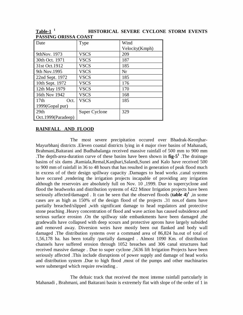
Table-1 1 HISTORICAL SEVERE CYCLONE STORM EVENTSPASSING ORISSA COASTDate Type Wind
Velocity(Kmph)9thNov. 1973 VSCS 20930th Oct. 1971 VSCS 18731st Oct.1912 VSCS 1859th Nov.1995 VSCS Nr22nd Sept. 1972 VSCS 18510th Sept. 1972 VSCS 17612th May 1979 VSCS 17016th Nov 1942 VSCS 16817th Oct.1999(Gopal pur)
VSCS 185
29thOct.1999(Paradeep)
Super Cyclone 329
RAINFALL AND FLOOD
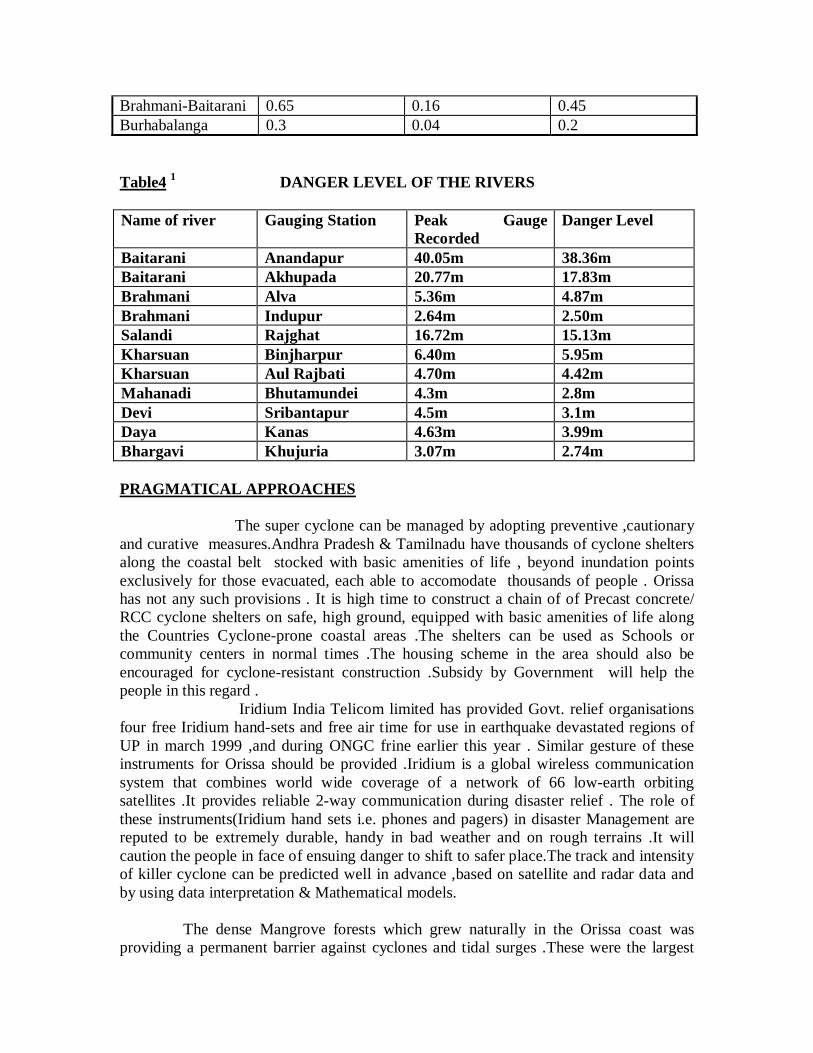
The most severe precipitation occured over Bhadrak-Keonjhar-Mayurbhanj districts .Eleven coastal districts lying in 4 major river basins of Mahanadi,Brahmani,Baitarani and Budhabalanga received massive rainfall of 500 mm to 900 mm.The depth-area-duration curve of these basins have been shown in fig-51 .The drainagebasins of six dams ,Ramiala,Remal,Kanjhari,Salandi,Sunei and Kalo have received 500to 900 mm of rainfall in 36 to 48 hours that has resulted in generation of peak flood muchin excess of of their design spillway capacity .Damages to head works ,canal systemshave occured ,rendering the irrigation projects incapable of providing any irrigationalthough the reservoirs are absolutely full on Nov. 10 ,1999. Due to supercyclone andflood the headworks and distribution systems of 422 Minor Irrigation projects have beenseriously affected/damaged . It can be seen that the observed floods (table 4)1 ,in somecases are as high as 150% of the design flood of the projects .31 nos.of dams havepartially breached/slipped ,with significant damage to head regulators and protectivestone peaching .Heavy concentration of flood and wave action has caused subsidence andserious surface erosion .On the spillway side embankments have been damaged ,thegradewalls have collapsed with deep scours and protective aprons have largely subsidedand removed away. Diversion weirs have mostly been out flanked and body walldamaged .The distribution systems over a command area of 86,824 ha.out of total of1,56,178 ha. has been totally /partially damaged . Almost 1090 Km. of distributionchannels have suffered erosion through 1052 breaches and 306 canal structures hadreceived massive damage . Due to super cyclone ,5636 lift Irrigation Projects have beenseriously affected .This include disruptions of power supply and damage of head worksand distribution system .Due to high flood ,most of the pumps and other machinarieswere submerged which require rewinding .
The deltaic track that received the most intense rainfall partcularly inMahanadi , Brahmani, and Baitarani basin is extremely flat with slope of the order of 1 in
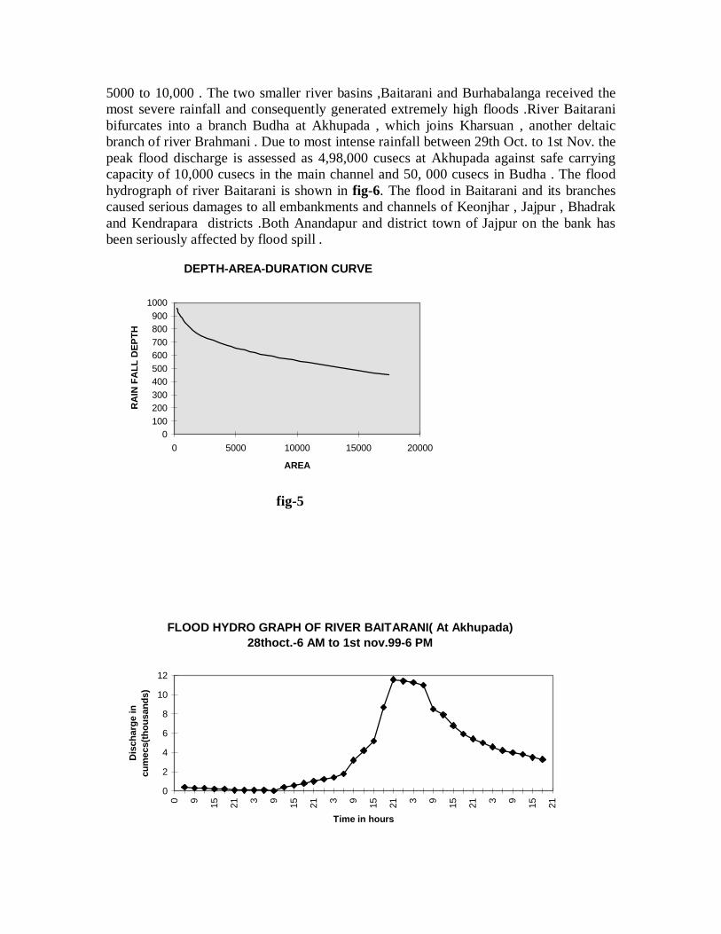
5000 to 10,000 . The two smaller river basins ,Baitarani and Burhabalanga received themost severe rainfall and consequently generated extremely high floods .River Baitaranibifurcates into a branch Budha at Akhupada , which joins Kharsuan , another deltaicbranch of river Brahmani . Due to most intense rainfall between 29th Oct. to 1st Nov. thepeak flood discharge is assessed as 4,98,000 cusecs at Akhupada against safe carryingcapacity of 10,000 cusecs in the main channel and 50, 000 cusecs in Budha . The floodhydrograph of river Baitarani is shown in fig-6. The flood in Baitarani and its branchescaused serious damages to all embankments and channels of Keonjhar , Jajpur , Bhadrakand Kendrapara districts .Both Anandapur and district town of Jajpur on the bank hasbeen seriously affected by flood spill .
DEPTH-AREA-DURATION CURVE
0100200300400500600700800900
1000
0 5000 10000 15000 20000
AREA
RA
IN F
ALL
DEP
TH
fig-5
FLOOD HYDRO GRAPH OF RIVER BAITARANI( At Akhupada)28thoct.-6 AM to 1st nov.99-6 PM
0
2
4
6
8
10
12
0 9 15 21 3 9 15 21 3 9 15 21 3 9 15 21 3 9 15 21
Time in hours
Dis
char
ge in
cum
ecs(
thou
sand
s)
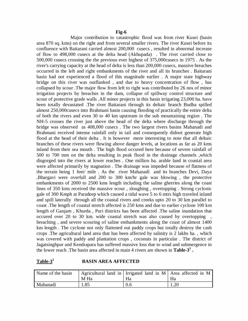
Fig-6 Major contribution to catastrophic flood was from river Kusei (basinarea 870 sq. kms) on the right and from several smaller rivers. The river Kusei before itsconfluence with Baitarani carried almost 200,000 cusecs , resulted in abnormal increaseof flow to 498,000 cusecs at the delta head (Akhupada) . The river carried close to500,000 cusecs crossing the the previous ever highest of 375,000cusecs in 1975 . As theriver's carrying capacity at the head of delta is less than 200,000 cusecs, massive breachesoccurred in the left and right embankments of the river and all its branches . Baitaranibasin had not experienced a flood of this magnitude earlier . A major state highwaybridge on this river was outflanked , and due to heavy concentration of flow , hascollapsed by scour .The major flow from left to right was contributed by 26 nos of minorirrigation projects by breaches in the dam, collapse of spillway control structure andscour of protective grade walls .All minor projects in this basin irrigating 23,000 ha. havebeen totally devastated .The river Baitarani through its deltaic branch Budha spilledalmost 250,000cusecs into Brahmani basin causing flooding of practically the entire deltaof both the rivers and even 30 to 40 km upstream in the sub mountaining region . TheNH-5 crosses the river just above the head of the delta where discharge through thebridge was observed as 408,000 cusecs . The two largest rivers basins Mahanadi andBrahmani received intense rainfall only in tail and consequently didnot generate highflood at the head of their delta . It is however more interesting to note that all deltaicbranches of these rivers were flowing above danger levels, at locations as far as 20 kmsinland from their sea mouth . The high flood occured here because of severe rainfall of500 to 700 mm on the delta resulting in peak flood in the drainage channels ,whichdisgorged into the rivers at lower reaches . One million ha. arable land in coastal areawere affected primarily by stagnation . The drainage was impeded because of flatness ofthe terrain being 1 feet/ mile . As the river Mahanadi and its branches Devi, Daya,Bhargavi were overfull and 200 to 300 km/hr gale was blowing , the protectiveembankments of 2000 to 2500 kms length including the saline gherries along the coastlines of 350 kms received the massive scour , sloughing , overtopping . Strong cyclonicgale of 300 Kmph at Paradeep which caused a tidal wave 5 to 6 mtrs high traveled inlandand spill laterally through all the coastal rivers and creeks upto 20 to 30 km parallel tocoast .The length of coastal stretch affected is 250 kms and due to earlier cyclone 100 kmlength of Ganjam , Khurda , Puri districts has been affected .The saline inundation thatoccured over 20 to 30 km. wide coastal stretch was also caused by overtopping ,breaching , and severe scouring of saline embankments along the coast of almost 1400km length . The cyclone not only flattened out paddy crops but totally destroy the cashcrops .The agricultural land area that has been affected by salinity is 2 lakhs ha. , whichwas covered with paddy and plantation crops , coconuts in particular . The district ofJagatsinghpur and Kendrapara has suffered massive loss due to wind and submergence inthe lower reach .The basin area affected in main 4 rivers are shown in Table-31 .
Table-31 BASIN AREA AFFECTED
Name of the basin Agricultural land inM Ha
Irrigated land in MHa
Area affected in MHa
Mahanadi 1.85 0.6 1.20
Brahmani-Baitarani 0.65 0.16 0.45Burhabalanga 0.3 0.04 0.2
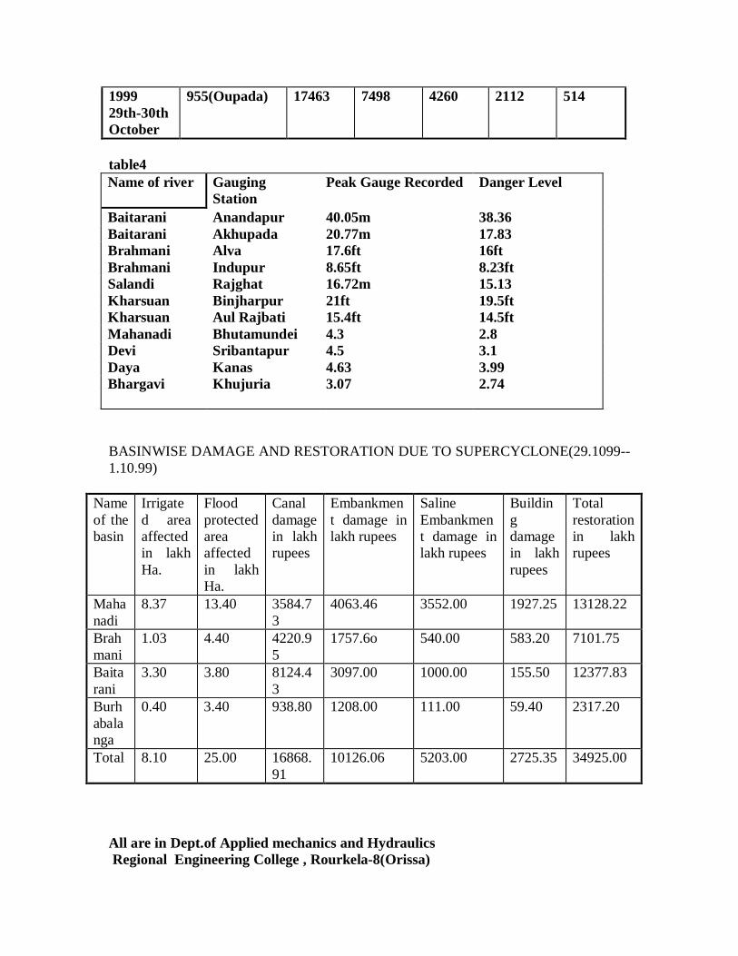
Table4 1 DANGER LEVEL OF THE RIVERS
Name of river Gauging Station Peak GaugeRecorded
Danger Level
Baitarani Anandapur 40.05m 38.36mBaitarani Akhupada 20.77m 17.83mBrahmani Alva 5.36m 4.87mBrahmani Indupur 2.64m 2.50mSalandi Rajghat 16.72m 15.13mKharsuan Binjharpur 6.40m 5.95mKharsuan Aul Rajbati 4.70m 4.42mMahanadi Bhutamundei 4.3m 2.8mDevi Sribantapur 4.5m 3.1mDaya Kanas 4.63m 3.99mBhargavi Khujuria 3.07m 2.74m
PRAGMATICAL APPROACHES
The super cyclone can be managed by adopting preventive ,cautionaryand curative measures.Andhra Pradesh & Tamilnadu have thousands of cyclone sheltersalong the coastal belt stocked with basic amenities of life , beyond inundation pointsexclusively for those evacuated, each able to accomodate thousands of people . Orissahas not any such provisions . It is high time to construct a chain of of Precast concrete/RCC cyclone shelters on safe, high ground, equipped with basic amenities of life alongthe Countries Cyclone-prone coastal areas .The shelters can be used as Schools orcommunity centers in normal times .The housing scheme in the area should also beencouraged for cyclone-resistant construction .Subsidy by Government will help thepeople in this regard . Iridium India Telicom limited has provided Govt. relief organisationsfour free Iridium hand-sets and free air time for use in earthquake devastated regions ofUP in march 1999 ,and during ONGC frine earlier this year . Similar gesture of theseinstruments for Orissa should be provided .Iridium is a global wireless communicationsystem that combines world wide coverage of a network of 66 low-earth orbitingsatellites .It provides reliable 2-way communication during disaster relief . The role ofthese instruments(Iridium hand sets i.e. phones and pagers) in disaster Management arereputed to be extremely durable, handy in bad weather and on rough terrains .It willcaution the people in face of ensuing danger to shift to safer place.The track and intensityof killer cyclone can be predicted well in advance ,based on satellite and radar data andby using data interpretation & Mathematical models.
The dense Mangrove forests which grew naturally in the Orissa coast wasproviding a permanent barrier against cyclones and tidal surges .These were the largest
deep forest of country .The unscrupulous clearence have made the coast bare and exposedto the vagaries of cyclones . According to official report the decay of the forest is 2 sq.kms per year .In 1960 the forest was 500 sq. kms , now it has reached to 190 sq. kms.Due to its rapid destruction the 1971 cyclone's has created a great disaster to Kendraparadistrict of Orissa .The restoration of mangrove forests requires a urgent attention .A goodcoordination is required between Finance, Forest and Environment departments.Stringent laws to preserve forests and to increase it by afforestation,plantation of windbreakers like Casuarina and similar trees in the coast will go a long way to reduce thespeed of wind . In delta areas wind resistant commercial plantation should be proposed inplace of Banana and Coconut tree which are very weak against wind force .
The proposal of construction of Highway between Gopalpur-Dighaalong the coast of 450 kms length and 7m high should be encouraged .The nationalHighway will join West bengal ,Orissa ,and Andhrapradesh along the coast which willnot only protect saline ingress due to tidal surges to delta but also will boost tourism.Intermediate escapes with slucies are to be provided along the raised high way tofacilitate drainage of the river channels to sea .
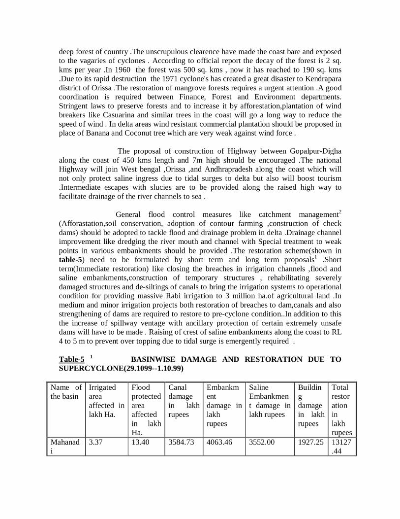
General flood control measures like catchment management2
(Afforastation,soil conservation, adoption of contour farming ,construction of checkdams) should be adopted to tackle flood and drainage problem in delta .Drainage channelimprovement like dredging the river mouth and channel with Special treatment to weakpoints in various embankments should be provided .The restoration scheme(shown intable-5) need to be formulated by short term and long term proposals1 .Shortterm(Immediate restoration) like closing the breaches in irrigation channels ,flood andsaline embankments,construction of temporary structures , rehabilitating severelydamaged structures and de-siltings of canals to bring the irrigation systems to operationalcondition for providing massive Rabi irrigation to 3 million ha.of agricultural land .Inmedium and minor irrigation projects both restoration of breaches to dam,canals and alsostrengthening of dams are required to restore to pre-cyclone condition..In addition to thisthe increase of spillway ventage with ancillary protection of certain extremely unsafedams will have to be made . Raising of crest of saline embankments along the coast to RL4 to 5 m to prevent over topping due to tidal surge is emergently required .
Table-5 1 BASINWISE DAMAGE AND RESTORATION DUE TOSUPERCYCLONE(29.1099--1.10.99)
Name ofthe basin
Irrigatedareaaffected inlakh Ha.
Floodprotectedareaaffectedin lakhHa.
Canaldamagein lakhrupees
Embankmentdamage inlakhrupees
SalineEmbankment damage inlakh rupees
Buildingdamagein lakhrupees
Totalrestorationinlakhrupees
Mahanadi
3.37 13.40 3584.73 4063.46 3552.00 1927.25 13127.44
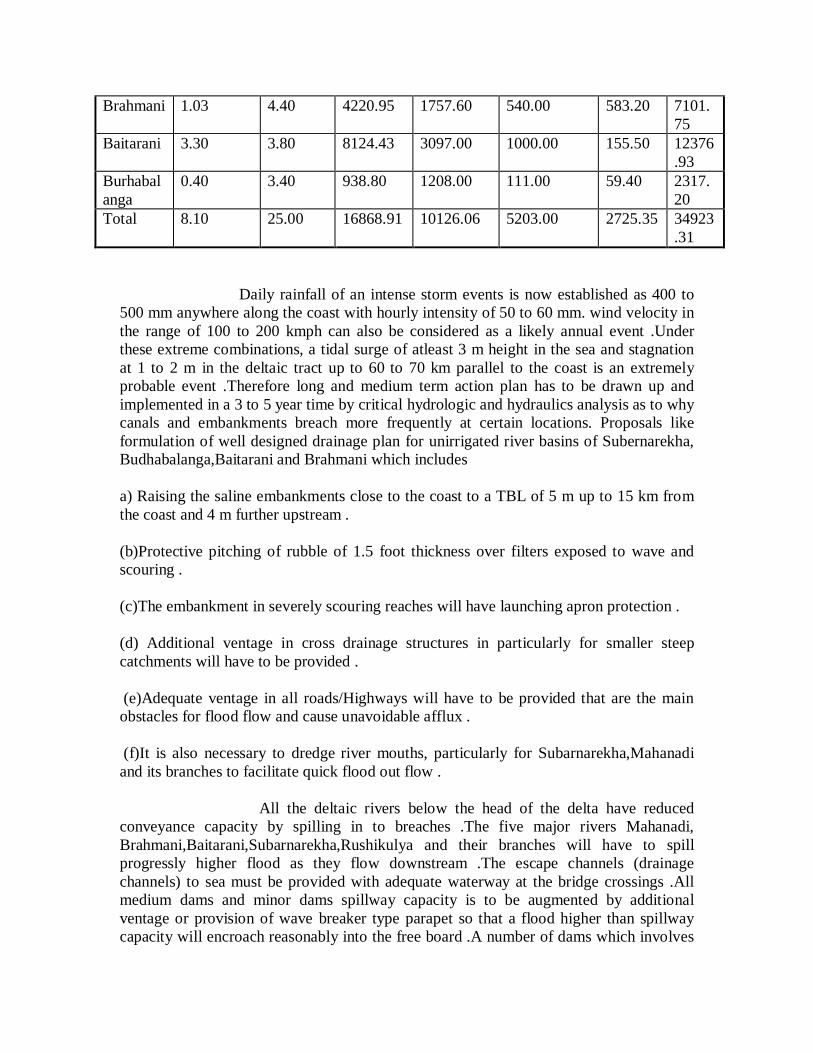
Brahmani 1.03 4.40 4220.95 1757.60 540.00 583.20 7101.75
Baitarani 3.30 3.80 8124.43 3097.00 1000.00 155.50 12376.93
Burhabalanga
0.40 3.40 938.80 1208.00 111.00 59.40 2317.20
Total 8.10 25.00 16868.91 10126.06 5203.00 2725.35 34923.31
Daily rainfall of an intense storm events is now established as 400 to500 mm anywhere along the coast with hourly intensity of 50 to 60 mm. wind velocity inthe range of 100 to 200 kmph can also be considered as a likely annual event .Underthese extreme combinations, a tidal surge of atleast 3 m height in the sea and stagnationat 1 to 2 m in the deltaic tract up to 60 to 70 km parallel to the coast is an extremelyprobable event .Therefore long and medium term action plan has to be drawn up andimplemented in a 3 to 5 year time by critical hydrologic and hydraulics analysis as to whycanals and embankments breach more frequently at certain locations. Proposals likeformulation of well designed drainage plan for unirrigated river basins of Subernarekha,Budhabalanga,Baitarani and Brahmani which includes
a) Raising the saline embankments close to the coast to a TBL of 5 m up to 15 km fromthe coast and 4 m further upstream .
(b)Protective pitching of rubble of 1.5 foot thickness over filters exposed to wave andscouring .
(c)The embankment in severely scouring reaches will have launching apron protection .
(d) Additional ventage in cross drainage structures in particularly for smaller steepcatchments will have to be provided .
(e)Adequate ventage in all roads/Highways will have to be provided that are the mainobstacles for flood flow and cause unavoidable afflux .
(f)It is also necessary to dredge river mouths, particularly for Subarnarekha,Mahanadiand its branches to facilitate quick flood out flow .
All the deltaic rivers below the head of the delta have reducedconveyance capacity by spilling in to breaches .The five major rivers Mahanadi,Brahmani,Baitarani,Subarnarekha,Rushikulya and their branches will have to spillprogressly higher flood as they flow downstream .The escape channels (drainagechannels) to sea must be provided with adequate waterway at the bridge crossings .Allmedium dams and minor dams spillway capacity is to be augmented by additionalventage or provision of wave breaker type parapet so that a flood higher than spillwaycapacity will encroach reasonably into the free board .A number of dams which involves
safety of a large population downstream have been found to have inadequate spillwaycapacity .Additional storage for flood moderation and provision of robust parapat,increased ventage in spillway with improved adequate energy dissipiating device mustbe incorporated . Assessing the spills down each deltaic river for floods of at least 1 in 50year return period and providing robust escape structures at correct locations in theembankments , and leading the spill over the low land quickly to the sea . Because thesevere cyclones that cause extremely intense precipitation over very large area along thecoastal belt occur frequently in Oct.-Nov. when the crop is maturing therefore the needfor drainage is paramount .In case of dams where very large and dense urban/ruralhabitation exist along the flood plain (Such as Bhadrak town and a number of villagesbelow Salandi Dam) a correct assessment of width of flood zone and shifting of habitantsfrom high flood prone zone is emergently needed . Almost 2,00,000 ha. of this supercyclone affected area experience moderate to severe crop loss in kharif and can not haveflow irrigation facility which will need complete double embankment of all deltaicchannels as a prerequisite .Most of the dam need special rehabilitation from long termstability consideration .Salandi earth dam in particular would need substantialrehabilitation including possible raising of the dam ,flattening of downstream slope,surface/subsurface drainage improvement as the peak inflow was two and half times thedesign spillway capacity .The track and intensity of the killer cyclone can be predictedand forecast well in advance ,based on satelite ,radar data and by using data interpretation& mathematical models. Forewarning of the disaster is required and where prevention isnot always possible , it is duty of the government to organise and manage short term andlong term relief that will reduce human miseries to the maximum extent possible .
CONCLUSION :
The super Cyclone ripped through the entire densly populated coastalOrissa in the absence of predisaster Management plans .The face of Orissa had beenscarred beyond recognisation . Government should have well formulated plans becauseCyclones are an annual scourage and they may return next October -November too andnone can predict the next scale of destruction .Therefore with adequate will ,with supportof community , NGO and every departments of Government , Calamities can be facedand human miseries can be reduced to the minimum .Since the cyclone seasons is April-May and Oct.-Nov. Committee has to be set up for a fresh look at disaster managementand meeting are to be held in March and September to take stock of preparedeness,supplies, rations. Disaster Management should be of permanent nature . It is high timethat both central and state govt. lend to the subject of disaster management .It would beworthwhile that both the centre and state should have separate department of Disastermanagement .Immediate restoration,Long and medium term action plan has to be drawnup and implemented by critical hydrologic and hydraulics analysis .The housing schemelike Pucca building should be encouraged for cyclone-resistant construction . Drinkingwater supply pipe line should be connected to all Cyclone prone villages from outside
area .In delta areas wind resistant4 commercial plantation should be proposed in place ofBanana ,Coconut and other similar trees .Provision of chain of cyclone shelters,Afforestation programme,Drainage improvement programme and provision of Iridiumphone sets in Cyclone-prone coastal areas like Orissa ,West Bengal ,and Gujurat areneeded . Resources may be constraint on states so centre should take up the matters.Besides structural measures non-structural measures like Forecast of cyclone by remotesensing and advance warning is a need to the area which can often provide adequatewarning sufficiently far in advance to permit orderly and complete evacution .Scrupulous cyclone and flood damage reduction can be done by emergency evacution .Management with more scientific and technical acumen has now been observed to be theonly viable alternative .
REFERENCES:1.Water resources department ,Government of Orissa , “Report of Super cyclone &severe cyclone -October1999 in Orissa”.2.Ray K. Linsley,J.B.Franzini & George Tchobanoglous , “Water resourcesEngineering” .Mc Graw-Hill International Editions(4th Edition)3.Malleswararao P., Srinivasu V. , Srinivasrao G. ," Cyclone and Flood Hazards in theeast Godavari districts of Andhrapradesh " Proceeding of National Seminar on DisasterManagement , Nov.-1999 , U.C.E.Burla. (Orissa )4. De. V.S.,Desai D.S. and Bhandai S.G.(1995) Cyclones and depressions over Indianseas and neighbourhood during 1994" Mousum Journal no 46 ,pp227to 234
In the last super cyclone out of 4997 kms of flood wall (river embankments)there were2243 nos of breaches of 205 kms long .Out of saline embankments 1518kms there were1289 nos of 123kms long breaches .Out of 11947 kms of channel embankments therewere 14881 nos of 230kms long breches and 70 nos of slucies of saline embankments hasbeen affected ..In the delta due to poor drainage of 420000ha. a master plan is required .
Elevan coastal districts lying in four major river basins of Mahanadi , Brahmani,Baitarani and Budhabalanga received massive rainfall of 500 mm to 600 mm and causedhigh floods in the drainage channels , which disgorged into the rivers in lower reachesand deep stagnation over three millions hactre of protected and un protected agricultureland .0.8 millon ha. of irrigated command and 2.5 million ha. of protective agriculturalland has suffered inconceivable damage . Country's 2nd worst Cyclone.IMD could predict the intensity and track of killer Cyclonewell in advance, based on satelite and Radar data.Using data interpretation mathematical models, They could fore cast accurately thatCyclone of 220 KMPH wind speed would hit the Orissa Coast 48 hours inadvance.Cyclone would hit the coast between puri in Orissa and Sagar island inWB.About 12hours ibefore it hit paradeep on Oct29.The IMD alerted the Orissa stateadministration of the impending danger to the port town .The cyclone died down on southern coast of Orissa bringing to an end the 3 day fury ofnature.The prediction of gale wind speed ranging from 80-300 KMPH also came true .** A Super Cyclone is one whose intensity -wind speed encountered in core-area atropical Cyclone equals or more than 226 KMPH.
SUPER CYCLONE IN STATE ORISSA AND ITS MANAGEMENT
Country's 2nd worst Cyclone.IMD could predict the intensity and track of killer Cyclonewell in advance, based on satelite and Radar data.Using data interpretation mathematical models, They could fore cast accurately thatCyclone of 220 KMPH wind speed would hit the Orissa Coast 48 hours inadvance.Cyclone would hit the coast between puri in Orissa and Sagar island inWB.About 12hours ibefore it hit paradeep on Oct29.The IMD alerted the Orissa stateadministration of the impending danger to the port town .The cyclone died down on southern coast of Orissa bringing to an end the 3 day fury ofnature.The prediction of gale wind speed ranging from 80-300 KMPH also came true .The supercyclone of Oct.29-Nov.1, 1999 and severe cyclone of oct.17-19, that precededthis , inflicted unprecedented damage in fourteen prosperous districts of the state thatdevastated 3 million ha. of cropped area, infrastructure in addition to sizeable loss ofhuman lives .The super cyclone that originated in the Bay of Bengal near Andaman-Nicobar Islands on 25th Oct. concentered into a severe cyclonic storm and had finallylandfall at Paradeep on 29th Oct. morning.Lashing practically the entire coastal stretch ofOrissa with wind velocity of around 300kmph at Paradeep. The super cyclone penetratedup to 150km inland and caused torrential precipitation over 45000 sqkm from the 29thoctober to 1st november .The basin wise break of area that received intense rainfall isgiven in table no1
RAINFALL The most severe precipitation occured over Bhadrak-Keonjhar-Mayurbhanjdistricts . Eleven coastal districts lying in 4 major river basins of Mahanadi,Brahmani,Baitarani and Budhabalanga received massive rainfall and caused high floodsand deep stagnation over 2.5 million Ha. of protected and unprotected agricultural landDEPTH-AREA DISTRIBUTION.**Orissa on the east Coast along with West Bengal and Andhrapradesh has thelocational disadvantage of being in the path of depression of severe cyclonic storms thatoccur during the south west monsoon (June 15 to October 31). Severe cyclone indeedoccurs when the Southwest monsoon recedes. Cyclonic storm also occur just before theonset of monsoon in late April-May-June spell.HISTORICAL SEVERE CYCLONE STORM EVENTS PASSING ORISSACOAST
SEVERE STORM EVENTS(HISTORICAL)Flood : the deltaic track that received the most intense rainfall partcularly in Mahanadi ,Brahmani, and Baitarani basin is extremely flat with slope of the order of 1 in 5000 to10,000 .The two largest rivers basins Mahanadi and Brahmani received intense rainfall only intail and consequently didnot generate high flood at the head of their delta . It is howevermore interesting to note that all deltaic branches of these rivers were flowing abovedanger level , at locations as far as 20 kms inland from their sea mouth . The high floodoccured here because severe rainfall of 500 to 600 mm on the delta resulted in peak floodin the drainage channels ,which disgorged into the rivers in lower reaches .table4
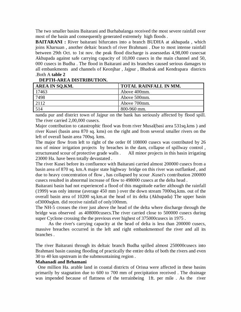
The two smaller basins Baitarani and Burhabalanga received the most severe rainfall overmost of the basin and consequently generated extremely high floods .BAITARANI : River baitarani bifurcates into a branch BUDHA at akhupada , whichjoins Kharsuan , another deltaic branch of river Brahmani . Due to most intense rainfallbetween 29th Oct. to 1st nov. the peak flood discharge is assessedas 4,98,000 cusecsatAkhupada against safe carrying capacity of 10,000 cusecs in the main channel and 50,000 cusecs in Budha . The flood in Baitarani and its branches caused serious damages toall embankments and channels of Keonjhar , Jajpur , Bhadrak and Kendrapara districts.Both A table 2
DEPTH-AREA DISTRIBUTION.AREA IN SQ.KM. TOTAL RAINFALL IN MM.17463 Above 400mm.7498 Above 500mm.2112 Above 700mm.514 800-960 mm.nanda pur and district town of Jajpur on the bank has seriously affected by flood spill.The river carried 2,00,000 cusecs.Major contribution to catastrophic flood was from river Musal(basi area 531sq.kms ) andriver Kusei (basin area 870 sq. kms) on the right and from several smaller rivers on theleft of overall basin area 700sq. kms.The major flow from left to right of the order 0f 108000 cusecs was contributed by 26nos of minor irrigation projects by breaches in the dam, collapse of spillway control ,structureand scour of protective grade walls . All minor projects in this basin irrigating23000 Ha. have been totally devastated .The river Kusei before its confluence with Baitarani carried almost 200000 cusecs from abasin area of 870 sq. km.A major state highway bridge on this river was outflanked , anddue to heavy concentration of flow , has collapsed by scour .Kusei's contribution 200000cusecs resulted in abnormal increase of flow to 498000 cusecs at the delta head .Baitarani basin had not experienced a flood of this magnitude earlier although the rainfall(1999) was only intense (average 450 mm ) over the down stream 7000sq.kms. out of theoverall basin area of 10200 sq.km.at the head of its delta (Akhupada) The upper basinof3000sqkm. did receive rainfall of only100mm.The NH-5 crosses the river just above the head of the delta where discharge through thebridge was observed as 408000cusecs.The river carried close to 500000 cusecs duringsuper Cyclone crossing the the previous ever highest of 375000cusecs in 1975 . As the river's carrying capacity at the head of delta is less than 200000 cusecs,massive breaches occurred in the left and right embankmentsof the river and all itsbranches .
The river Baitarani through its deltaic branch Budha spilled almost 250000cusecs intoBrahmani basin causing flooding of practically the entire delta of both the rivers and even30 to 40 km upstream in the submountaining region .Mahanadi and Brhamani One million Ha. arable land in coastal districts of Orissa were affected in these basinsprimarily by stagnation due to 600 to 700 mm of precipitation received . The drainagewas impended because of flattness of the terrainbeing 1ft. per mile . As the river
Mahanadi and its branches Devi, Daya ,Bhargavi were overfull and 200 to 300 km/hrgale was blowing , the protective embankments of 2000 to 2500 kms length including thesaline gherries along the coast lines of 350 kms received the massive scour , sloughing ,overtopping .Strong cyclonic gale of 300KMPH at Paradeep which caused a tidal wave 5 to 6 mtrshigh travel inland and spill laterally through all the coastal rivers and creeks upto 20 to30km parallel to coast . the length of coastal stretch affected is 250 kms and due to earliercyclone 100 km length of Ganjam , Khurda , Puri districts has been affected .The salineinudation that occured over 20 to 30 km. wide coastal stretch was also caused byovertopping , breaching , and severe scouring of saline embankments along the coast ofalmost 1400 km length .The agricultural land area that has been affected by salinity is 2 lakhs Ha , which wascovered with paddy and plantation crops , coconuts in particular .The cyclone not onlyflattened out paddy crops but totally destroy the cash crops .The district of Jagatsingh pur and Kendrapara has suffered massive loss due to wind andsubmergence in the lower reach .))))))))))))In AP after 1977 cyclone , left 10,000 dead ,Cyclone shelters were constructed whichprotected one million in shelters in 1997 Cyclone.AP has 1041 cyclone shelters stockedwith basic aminities along coastal belt , beyond inundation points exclusively for thoseevacuated , each able to accomodate thousands of people . There are cyclone shelters inTN. Orissa has no any or at least such provisions .The super Cyclone ripped throughOrissa's densly populated Coastal districts in the absence of pre disaster Managementplans.Committee has to be setup for a fresh look at disaster management. It is the time toconstruct chain of cyclone shelters , equipped with basic amenities along the CountriesCyclone -prone coastal areas like Orissa , WB ,and Gujurat Resources may be constrainton states so centre should take up the responsibility .Devastation can not be stopped but lives can be saved .The design is not right and construction is poor .There is no road links to these. Thoughwarning came 48 hours earlier.The housing scheme should be encouraged for cyclone-resistant construction . Puccabuilding is the safe places.Since the cyclone seasons is April-May and Oct.-Nov. Meeting are held in March andSept. to take stock of preparedeness suppliers, rations.Precast concrete, RCC Reinforcements storm shelters on safe, perhaps high ground..A first aid-kit non-perishable food and water , battery powered Radio. Flash light andextra batteries. shelters able to accomodate 500 to 600 people at a time should have suchbasics.Communication among other things need a look.The entire efforts would have tobe supplimented with better tracking and monitoring of Cyclones and storm surges , Theassociated abnormal rise of sea level and assessment of areas likely to be inundated .
Iridium India, sole provider of satellite phones in the country has already been floodedwith in quiries from Government agencies and Industries for purchase of fresh phones ,under scoring the role of these instruments in disaster Management .
Although Iridium India Telicom limited has provided Govt. relief organisations 4 freeIridium hand-setsand free air time for use in earthquake devasted regions of UP in march1999.and during ONGC frine earlier this year , No decision had been taken on to come upwith a similar gesture for Orissa.1Iridium is a global wireless communication system that combines world wide coverageof a network of 66 low-earth orbiting satellites . It provides reliable 2-waycommunication during disaster relief.Iridium hand sets and pagers are reputed to be extremely durable, handy in bad weatherand on rough terrains..Atleast 10millions of people had been affected in 10 coastal districts of the state whoseentire coastal region had been severely hit in cyclone that struck at 300KMPHTidal waves as high as 10 to 15 m have inundated vast tracks of the regions and sweptaway entire villages .1.5 crore of people have been affected 25 lakh houses damaged1600 army personnel with necessary rescue equipment were rescuing with relief .The Oct.18 Cyclone in Ganjam dist measured 4 on beauford scale , It killed 150 livesaffecting 5 lakh peoples. but Oct.29 will be more than 6 on beauford scale .Orissa will be never be same again . Thousands of houses razed to the ground , treesuprooted , electricand telephone poles twisted .Unprecedented gale that touched 300KMPH. The cyclone lasted about 48 hours. Thewhole coastal regions is filled with nauseating stench of rotting dead .The face of Orissa has been scarred beyond recognisation.The super cyclone hit Paradeep coast at a speed of 260KMPH on friday.*****5 . The most of the houses in rural and towns are constructed either with thached roofs orwith tile roofs ,which are more prone to damages due to severe winds. Hence Cycloneresistance houses constructed with R.C.C slabs will reduce house damages.The placehaving greater than 10m have to be identified and the housing colonies shall be devlopedin these identified areas.1.The drainage systems in delta area should be improved by forming embankments oneither side and removing silts deposited and clearing the vegetation in the bed of drains ,to minimise the crop damage .2 . In delta areas wind resistance commercial plantation should be proposed in place ofBananaand Cocanut tree which are very weak against wind force .3 . The towns and villages below 10m contour need attention to prevent damages causedby Cyclone and Flood .4 . Drinking water supply pipe line should be connected to all villages in Cyclone pronearea supplying water from outside area.******The study of Cyclone tracks indicated that Cyclones are crossing the east coast eitherbetween WB and Bangladeshor at the coast of AP and Madras.The damages due to superCyclone are studied and need for change in plantation pattern, housing system andimprovements to the drainage systemsis discussed
There were Mangrove forests in the coastal area nearer to sea and now it is decliningrapidly. Due to rapid destruction of these forest the intensity of cyclones are becoming
high and destroying the lives and properties in high amounts . According to official reportthe decay of the forest is 2 sq. kms per year but actual decay will be more than 5 sq. kms.In 1960 thearea of the forest was 500 sq. kms , due to that the the tidal effect was alsoless. Now it has reached to 190 sq. kms.but it is doubt ful to have 100sq. kms . Due to itsrapid destruction the 1971 cyclone's has crated a great disaster to Kendrapara districtarea .Centr is interested to invest 5 crore rupees every year but state govt is unable toexpense 50 lakh rupees . A good coordination is required between finance departmentForest and Environment departments . These mangrove forests were the largest deepforest of country .In the next 10 years these forest may totaly disappear .Now it is time tocheck deforestation and afforastation programe should be started immediately with goodcoordinations of forest ,environmental and finance department ..
Gopal pur-Digha sea beach national highway (BELA BHUMI ): AP Orissa , WB are tobe connected by sea beach national highway (BELA BHUMI ). this was proposed by lateBiju pattnaik former CM of Orissa in 1990 and the estimate was 500 crores .In Orissathere are 450 kms of sea beach (BELA BHUMI ). From Gopal pur to Digha along theshore sea beach national highway (BELA BHUMI ) of 7m high are proposed byGeographicians. It is necessary as along the shore many Defence institutes (8 nos)existsso Ministry of defence may take the responsibility to build it . This NH may alsoencourage the tourism in beach shore . Two things are essentials to prevent from Cyclone1. To construct NH of 450 kms along the shore of sea coast , now it costs about 1000crores of rupees . 2. To create the artficial forests like mangrove forests .
REFERENCES:1. De. V.S.,Desai D.S. and Bhandai S.G.(1995) Cyclones and depressions over Indianseas and neighbourhood during 1994" Mousum Journal no 46 ,pp227to 2342.Malleswararao P., Srinivasu V. , Srinivasrao G. ," Cyclone and Flood Hazards in theeast Godavari districts of Andhrapradesh " Proceeding of National Seminar on DisasterManagement , Nov.-1999 , U.C.E.Burla. (Orissa )
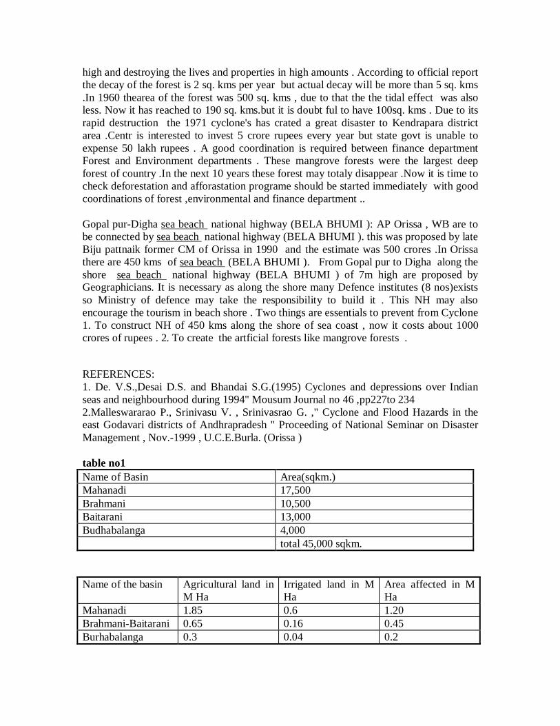
table no1Name of Basin Area(sqkm.)Mahanadi 17,500Brahmani 10,500Baitarani 13,000Budhabalanga 4,000
total 45,000 sqkm.
Name of the basin Agricultural land inM Ha
Irrigated land in MHa
Area affected in MHa
Mahanadi 1.85 0.6 1.20Brahmani-Baitarani 0.65 0.16 0.45Burhabalanga 0.3 0.04 0.2
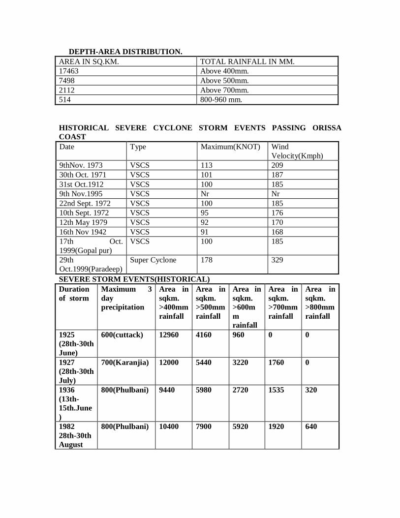
DEPTH-AREA DISTRIBUTION.AREA IN SQ.KM. TOTAL RAINFALL IN MM.17463 Above 400mm.7498 Above 500mm.2112 Above 700mm.514 800-960 mm.
HISTORICAL SEVERE CYCLONE STORM EVENTS PASSING ORISSACOASTDate Type Maximum(KNOT) Wind
Velocity(Kmph)9thNov. 1973 VSCS 113 20930th Oct. 1971 VSCS 101 18731st Oct.1912 VSCS 100 1859th Nov.1995 VSCS Nr Nr22nd Sept. 1972 VSCS 100 18510th Sept. 1972 VSCS 95 17612th May 1979 VSCS 92 17016th Nov 1942 VSCS 91 16817th Oct.1999(Gopal pur)
VSCS 100 185
29thOct.1999(Paradeep)
Super Cyclone 178 329
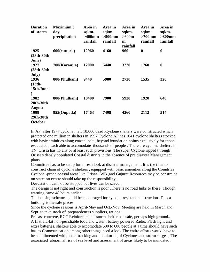
SEVERE STORM EVENTS(HISTORICAL)Durationof storm
Maximum 3dayprecipitation
Area insqkm.>400mmrainfall
Area insqkm.>500mmrainfall
Area insqkm.>600mmrainfall
Area insqkm.>700mmrainfall
Area insqkm.>800mmrainfall
1925(28th-30thJune)
600(cuttack) 12960 4160 960 0 0
1927(28th-30thJuly)
700(Karanjia) 12000 5440 3220 1760 0
1936(13th-15th.June)
800(Phulbani) 9440 5980 2720 1535 320
198228th-30thAugust
800(Phulbani) 10400 7900 5920 1920 640
199929th-30thOctober
955(Oupada) 17463 7498 4260 2112 514
table4Name of river Gauging
StationPeak Gauge Recorded Danger Level
Baitarani Anandapur 40.05m 38.36Baitarani Akhupada 20.77m 17.83Brahmani Alva 17.6ft 16ftBrahmani Indupur 8.65ft 8.23ftSalandi Rajghat 16.72m 15.13Kharsuan Binjharpur 21ft 19.5ftKharsuan Aul Rajbati 15.4ft 14.5ftMahanadi Bhutamundei 4.3 2.8Devi Sribantapur 4.5 3.1Daya Kanas 4.63 3.99Bhargavi Khujuria 3.07 2.74
BASINWISE DAMAGE AND RESTORATION DUE TO SUPERCYCLONE(29.1099--1.10.99)
Nameof thebasin
Irrigated areaaffectedin lakhHa.
Floodprotectedareaaffectedin lakhHa.
Canaldamagein lakhrupees
Embankment damage inlakh rupees
SalineEmbankment damage inlakh rupees
Buildingdamagein lakhrupees
Totalrestorationin lakhrupees
Mahanadi
8.37 13.40 3584.73
4063.46 3552.00 1927.25 13128.22
Brahmani
1.03 4.40 4220.95
1757.6o 540.00 583.20 7101.75
Baitarani
3.30 3.80 8124.43
3097.00 1000.00 155.50 12377.83
Burhabalanga
0.40 3.40 938.80 1208.00 111.00 59.40 2317.20
Total 8.10 25.00 16868.91
10126.06 5203.00 2725.35 34925.00
All are in Dept.of Applied mechanics and Hydraulics Regional Engineering College , Rourkela-8(Orissa)
Drainage systems in delta area should be improved by forming embankments on eitherside and removing silts deposited and clearing the vegetation in the bed of drains ,tominimise the crop damage .2 .3 . The towns and villages below 10m contour need attention to prevent damagescaused by Cyclone and Flood .4 . Drinking water supply pipe line should be connected to all villages in Cyclone pronearea supplying water from outside area.******The study of Cyclone tracks indicated that Cyclones are crossing the east coast eitherbetween WB and Bangladeshor at the coast of AP and Madras.The damages due to superCyclone are studied and need for change in plantation pattern, housing system andimprovements to the drainage systemsis discussedGopal pur-Digha sea beach national highway (BELA BHUMI ): AP Orissa , WB are tobe connected by sea beach national highway (BELA BHUMI ). this was proposed by lateBiju pattnaik former CM of Orissa in 1990 and the estimate was 500 crores .In Orissathere are 450 kms of sea beach (BELA BHUMI ). From Gopal pur to Digha along theshore sea beach national highway (BELA BHUMI ) of 7m high are proposed byGeographicians. It is necessary as along the shore many Defence institutes (8 nos)existsso Ministry of defence may take the responsibility to build it . This NH may alsoencourage the tourism in beach shore . Two things are essentials to prevent from Cyclone1. To construct NH of 450 kms along the shore of sea coast , now it costs about 1000crores of rupees . 2. To create the artficial forests like mangrove forests .Let India plan and preparebefore the next calamity like cyclone and flood takes herunguarded way.
Devastation can not be stopped but lives can be saved .The design is not right and construction is poor .There is no road links to these. Thoughwarning came 48 hours earlier.
A first aid-kit non-perishable food and water , battery powered Radio. Flash light andextra batteries. shelters able to accomodate 500 to 600 people at a time should have suchbasics.Communication among other things need a look.The entire efforts would have tobe supplimented with better tracking and monitoring of Cyclones and storm surges , Theassociated abnormal rise of sea level and assessment of areas likely to be inundated .
Iridium is a global wireless communication system that combines world wide coverage ofa network of 66 low-earth orbiting satellites . It provides reliable 2-way communicationduring disaster relief .Iridium hand sets and pagers are reputed to be extremely durable,handy in bad weather and on rough terrains.
Atleast 10millions of people had been affected in 10 coastal districts of the state whoseentire coastal region had been severely hit in cyclone that struck at 300KMPHTidal waves as high as 10 to 15 m have inundated vast tracks of the regions and sweptaway entire villages .1.5 crore of people have been affected 25 lakh houses damaged1600 army personnel with necessary rescue equipment were rescuing with relief .The Oct.18 Cyclone in Ganjam dist measured 4 on beauford scale , It killed 150 livesaffecting 5 lakh peoples. but Oct.29 will be more than 6 on beauford scale .
Orissa will be never be same again . Thousands of houses razed to the ground , treesuprooted , electricand telephone poles twisted .Unprecedented gale that touched 300KMPH. The cyclone lasted about 48 hours. Thewhole coastal regions is filled with nauseating stench of rotting dead .The face of Orissa has been scarred beyond recognisation.The super cyclone hit Paradeep coast at a speed of 260KMPH on friday.*****5 . The most of the houses in rural and towns are constructed either with thachedroofs or with tile roofs ,which are more prone to damages due to severe winds. HenceCyclone resistance houses constructed with R.C.C slabs will reduce house damages.Theplace having greater than 10m have to be identified and the housing colonies shall bedevloped in these identified areas.1.The deltaic track that received the most intense rainfall partcularly in Mahanadi ,Brahmani, and Baitarani basin is extremely flat with slope of the order of 1 in 5000 to10,000 .
Iridium India, sole provider of satellite phones in the country has already been floodedwith in quiries from Government agencies and Industries for purchase of fresh phones ,under scoring the role in disaster Management .
SUPER CYCLONE IN STATE ORISSA AND ITS MANAGEMENT
The supercyclone of Oct.29-Nov.1, 1999 and severe cyclone of oct.17-19, that precededthis , inflicted unprecedented damage in fourteen prosperous districts of the state thatdevastated 3 million ha. of cropped area, infrastructure in addition to sizeable loss ofhuman lives .The super cyclone that originated in the Bay of Bengal near Andaman-Nicobar Islands on 25th Oct. concentered into a severe cyclonic storm and had finallylandfall at Paradeep on 29th Oct. morning.Lashing practically the entire coastal stretch ofOrissa with wind velocity of around 300kmph at Paradeep. The super cyclone penetratedup to 150km inland and caused torrential precipitation over 45000 sqkm from the 29thoctober to 1st november .The basin wise breeak of area that received intense rainfall isgiven in table no1Name of Basin Area(sqkm.)Mahanadi 17,500Brahmani 10,500Baitarani 13,000Budhabalanga 4,000
total 45,000 sqkm. The largest concenetration of urban population of 1.5 million in Cuttack andBhubaneswar suffered unprecedented damage from intense rainfall of 500 to 600 mm andcyclonic gale of 200-250 Km/hr. The densely populated coastal districts were also totallydevastated in the cyclonic gale and severe rain.
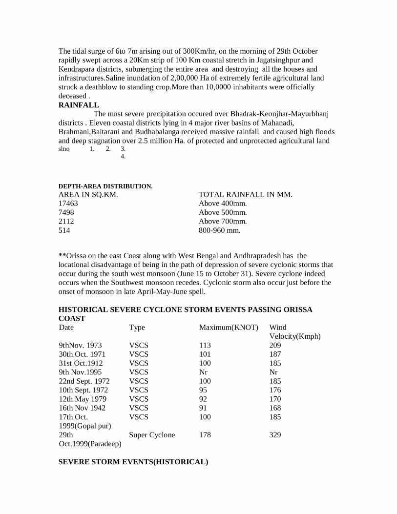
The tidal surge of 6to 7m arising out of 300Km/hr, on the morning of 29th Octoberrapidly swept across a 20Km strip of 100 Km coastal stretch in Jagatsinghpur andKendrapara districts, submerging the entire area and destroying all the houses andinfrastructures.Saline inundation of 2,00,000 Ha of extremely fertile agricultural landstruck a deathblow to standing crop.More than 10,0000 inhabitants were officiallydeceased .RAINFALL The most severe precipitation occured over Bhadrak-Keonjhar-Mayurbhanjdistricts . Eleven coastal districts lying in 4 major river basins of Mahanadi,Brahmani,Baitarani and Budhabalanga received massive rainfall and caused high floodsand deep stagnation over 2.5 million Ha. of protected and unprotected agricultural landslno 1. 2. 3.
4.
DEPTH-AREA DISTRIBUTION.AREA IN SQ.KM. TOTAL RAINFALL IN MM.17463 Above 400mm.7498 Above 500mm.2112 Above 700mm.514 800-960 mm.
**Orissa on the east Coast along with West Bengal and Andhrapradesh has thelocational disadvantage of being in the path of depression of severe cyclonic storms thatoccur during the south west monsoon (June 15 to October 31). Severe cyclone indeedoccurs when the Southwest monsoon recedes. Cyclonic storm also occur just before theonset of monsoon in late April-May-June spell.
HISTORICAL SEVERE CYCLONE STORM EVENTS PASSING ORISSACOASTDate Type Maximum(KNOT) Wind
Velocity(Kmph)9thNov. 1973 VSCS 113 20930th Oct. 1971 VSCS 101 18731st Oct.1912 VSCS 100 1859th Nov.1995 VSCS Nr Nr22nd Sept. 1972 VSCS 100 18510th Sept. 1972 VSCS 95 17612th May 1979 VSCS 92 17016th Nov 1942 VSCS 91 16817th Oct.1999(Gopal pur)
VSCS 100 185
29thOct.1999(Paradeep)
Super Cyclone 178 329
SEVERE STORM EVENTS(HISTORICAL)
Durationof storm
Maximum 3dayprecipitation
Area insqkm.>400mmrainfall
Area insqkm.>500mmrainfall
Area insqkm.>600mmrainfall
Area insqkm.>700mmrainfall
Area insqkm.>800mmrainfall
1925(28th-30thJune)
600(cuttack) 12960 4160 960 0 0
1927(28th-30thJuly)
700(Karanjia) 12000 5440 3220 1760 0
1936(13th-15th.June)
800(Phulbani) 9440 5980 2720 1535 320
198228th-30thAugust
800(Phulbani) 10400 7900 5920 1920 640
199929th-30thOctober
955(Oupada) 17463 7498 4260 2112 514
In AP after 1977 cyclone , left 10,000 dead ,Cyclone shelters were constructed whichprotected one million in shelters in 1997 Cyclone.AP has 1041 cyclone shelters stockedwith basic aminities along coastal belt , beyond inundation points exclusively for thoseevacuated , each able to accomodate thousands of people . There are cyclone shelters inTN. Orissa has no any or at least such provisions .The super Cyclone ripped throughOrissa's densly populated Coastal districts in the absence of pre disaster Managementplans.Committee has to be setup for a fresh look at disaster management. It is the time toconstruct chain of cyclone shelters , equipped with basic amenities along the CountriesCyclone -prone coastal areas like Orissa , WB ,and Gujurat Resources may be constrainton states so centre should take up the responsibility .Devastation can not be stopped but lives can be saved .The design is not right and construction is poor .There is no road links to these. Thoughwarning came 48 hours earlier.The housing scheme should be encouraged for cyclone-resistant construction . Puccabuilding is the safe places.Since the cyclone seasons is April-May and Oct.-Nov. Meeting are held in March andSept. to take stock of preparedeness suppliers, rations.Precast concrete, RCC Reinforcements storm shelters on safe, perhaps high ground..A first aid-kit non-perishable food and water , battery powered Radio. Flash light andextra batteries. shelters able to accomodate 500 to 600 people at a time should have suchbasics.Communication among other things need a look.The entire efforts would have tobe supplimented with better tracking and monitoring of Cyclones and storm surges , Theassociated abnormal rise of sea level and assessment of areas likely to be inundated .
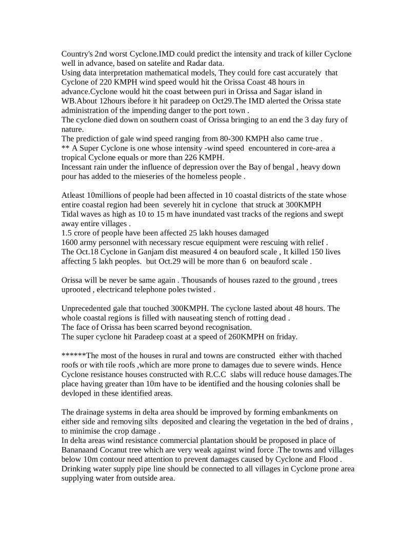
Country's 2nd worst Cyclone.IMD could predict the intensity and track of killer Cyclonewell in advance, based on satelite and Radar data.Using data interpretation mathematical models, They could fore cast accurately thatCyclone of 220 KMPH wind speed would hit the Orissa Coast 48 hours inadvance.Cyclone would hit the coast between puri in Orissa and Sagar island inWB.About 12hours ibefore it hit paradeep on Oct29.The IMD alerted the Orissa stateadministration of the impending danger to the port town .The cyclone died down on southern coast of Orissa bringing to an end the 3 day fury ofnature.The prediction of gale wind speed ranging from 80-300 KMPH also came true .** A Super Cyclone is one whose intensity -wind speed encountered in core-area atropical Cyclone equals or more than 226 KMPH.Incessant rain under the influence of depression over the Bay of bengal , heavy downpour has added to the mieseries of the homeless people .
Atleast 10millions of people had been affected in 10 coastal districts of the state whoseentire coastal region had been severely hit in cyclone that struck at 300KMPHTidal waves as high as 10 to 15 m have inundated vast tracks of the regions and sweptaway entire villages .1.5 crore of people have been affected 25 lakh houses damaged1600 army personnel with necessary rescue equipment were rescuing with relief .The Oct.18 Cyclone in Ganjam dist measured 4 on beauford scale , It killed 150 livesaffecting 5 lakh peoples. but Oct.29 will be more than 6 on beauford scale .
Orissa will be never be same again . Thousands of houses razed to the ground , treesuprooted , electricand telephone poles twisted .
Unprecedented gale that touched 300KMPH. The cyclone lasted about 48 hours. Thewhole coastal regions is filled with nauseating stench of rotting dead .The face of Orissa has been scarred beyond recognisation.The super cyclone hit Paradeep coast at a speed of 260KMPH on friday.
******The most of the houses in rural and towns are constructed either with thachedroofs or with tile roofs ,which are more prone to damages due to severe winds. HenceCyclone resistance houses constructed with R.C.C slabs will reduce house damages.Theplace having greater than 10m have to be identified and the housing colonies shall bedevloped in these identified areas.
The drainage systems in delta area should be improved by forming embankments oneither side and removing silts deposited and clearing the vegetation in the bed of drains ,to minimise the crop damage .In delta areas wind resistance commercial plantation should be proposed in place ofBananaand Cocanut tree which are very weak against wind force .The towns and villagesbelow 10m contour need attention to prevent damages caused by Cyclone and Flood .Drinking water supply pipe line should be connected to all villages in Cyclone prone areasupplying water from outside area.
The study of Cyclone tracks indicated that Cyclones are crossing the east coast eitherbetween WB and Bangladeshor at the coast of AP and Madras.The damages due to superCyclone are studied and need for change in plantation pattern, housing system andimprovements to the drainage systemsis discussed
Cyclonic storms: The tracks of the various Cyclonic storms are in the Bay of bengalbetween 1891-1997 reveals that most of the Cyclonic storms are crossing the east coastthrough coastal Orissa and East Godavari district of AP .
There were Mangrove forests in the coastal area nearer to sea and now it is decliningrapidl . Due to rapid destruction of these forest the intensity of cyclones are becominghigh and destroying the lives and properties in high amounts . According to official reportthe decay of the forest is 2 sq. kms per year but actual decay will be more than 5 sq. kms.In 1960 thearea of the forest was 500 sq. kms , due to that the the tidal effect was alsoless. Now it has reached to 190 sq. kms.but it is doubt ful to have 100sq. kms . Due to itsrapid destruction the 1971 cyclone's has crated a great disaster to Kendrapara districtarea .Centr is interested to invest 5 crore rupees every year but state govt is unable toexpense 50 lakh rupees . A good coordination is required between finance departmentForest and Environment departments . These mangrove forests were the largest deepforest of country .In the next 10 years these forest may totaly disappear .Now it is time tocheck deforestation and afforastation programe should be started immediately with goodcoordinations of forest ,environmental and finance department ..
Gopal pur-Digha sea beach national highway (BELA BHUMI ): AP Orissa , WB are tobe connected by sea beach national highway (BELA BHUMI ). this was proposed by lateBiju pattnaik former CM of Orissa in 1990 and the estimate was 500 crores .In Orissathere are 450 kms of sea beach (BELA BHUMI ). From Gopal pur to Digha along theshore sea beach national highway (BELA BHUMI ) of 7m high are proposed byGeographicians. It is necessary as along the shore many Defence institutes (8 nos)existsso Ministry of defence may take the responsibility to build it . This NH may alsoencourage the tourism in beach shore . Two things are essentials to prevent from Cyclone1. To construct NH of 450 kms along the shore of sea coast , now it costs about 1000crores of rupees . 2. To create the artficial forests like mangrove forests .
REFERENCES:1. De. V.S.,Desai D.S. and Bhandai S.G.(1995) Cyclones and depressions over Indianseas and neighbourhood during 1994" Mousum Journal no 46 ,pp227to 2342.Malleswararao P., Srinivasu V. , Srinivasrao G. ," Cyclone and Flood Hazards in theeast Godavari districts of Andhrapradesh " Proceeding of National Seminar on DisasterManagement , Nov.-1999 , U.C.E.Burla. (Orissa )
In the last super cyclone out of 4997 kms of flood wall (river embankments)there were2243 nos of breaches of 205 kms long .Out of saline embankments 1518kms there were1289 nos of 123kms long breaches .Out of 11947 kms of channel embankments there
were 14881 nos of 230kms long breches and 70 nos of slucies of saline embankments hasbeen affected ..In the delta due to poor drainage of 420000ha. a master plan is required .
.
Extended Abstract**
MANAGEMENT OF SUPERCYCLONE AND FLOOD IN ORISSA
Sri K.K.Khatua LecturerDepartment of Applied mechanics& hydraulics ,Regional Engineering CollegeRourkela-769008 (Orissa)
The state of Orissa is frequented by natural disasters like cycloneand flood year after year .The severe cyclone of october 17th and the super cyclone ofoctober 29th ,1999 devastated fourteen coastal districts throwing the lives of one crore ofpeople out of gear . More than 10,000 people were declared officially dead , three lakhsof cattle perished , nineteen lakh houses were razed to the ground . Coastal Orissa whichwas full of greenery virtually turned barren with over nine crores of trees uprooted .Thesupercyclone not only flattened out paddy crops but totally destroyed other cash crops .Eleven coastal districts lying in five major river basins of Mahanadi , Brahmani ,Baitarani , Budhabalanga and Subarnarekha received heavy rainfall of 500mm to 600mmand caused high flood in the drainage channels which disrgorged in to the delta at thelower reaches and deep stagnation of water over three million hectares of agriculturalland occured . As the rivers were overflowing and strong unprecedented cyclonic gale of200 to 300 kmph was blowing large stretch of protective and saline embankments gaveway by massive scouring , sloughing and overtopping . Breaches in the dams , collapse of
spillway structures occured in many minor irrigation projects of the state .The loss due tocyclone , super cyclone and flood is estimated to be around 20,000 crores of rupee . The super cyclone can be managed by adopting preventive ,cautionary and curative mesures . The dense mangrove forests which grew naturally inthe Orissa coast was providing a permanent barrier against cyclone and tidal surges . Theunscrupulus clearance have made the coast bare and exposed it to the vagaries ofcyclones . According to the official report the loss of the forest is at the rate of eightsq.kms per year . As a reasult it has depleted to 190 sq. kms from 500 sq.km whichexisted in the year 1960 .The restoration of mangrove forests requires urgent attention offorest and environment department . Stringent laws for preservation and extension byway of afforestation specially by wind breakers like Casuarina and similar trees in thecoast will go a long way to reduce the speed of cyclone .The proposal of construction ofHigh way between Gopalpur and Digha along the 450 km coastline should beimplemented which will not only prevent saline ingress due to tidal surges but also willboost tourism . Intermediate escapes and sluices are to be provided along the raisedhighway for upstream drainage . Protective sea walls near the human settlements is apreventive measures against tidal surges .
** Actual abstract with in 500 words will be submitted along with final paper .
Cautionary measures like installation of radars , providing with Iridium hand sets andpagers (which are reputed to be extremely durable , handy in bad weather and roughterrains and provides reliable two-way communications during disaster ) will caution thepeople in face of ensuing danger to shift to safer places . The track and intensity of killercyclone can be predicted well in advance , based on satellite and radar data and by usingdata interpretation & Mathematical models . Forewarning of the disaster is desired andwhere prevention is not possible , it is the duty of the government to organise andmanage short term and long term relief measures that reduce human miseries to themaximum extent . Andhrapradesh and Tamilnadu have thousands of cyclone sheltersalong the coastal belt , stocked with basic amenities of life . Orissa is not having any suchcyclone shelters . It is high time to go for construction of a chain of Precast / R.C.Ccyclone shelters on safe and high ground .The shelters can be used as schools orcommunity centers in normal times . The affected peoples should be encouraged to go forcyclone resistant R.C.C.construction . Subsidy by government will help the people in theregard . Evacuating people of Jambu area of Kendrapara district and Ersama area ofJagatsinghpur district should be taken up by government to save the people .
It is a pity that coastal orissa is frequently exposed to high flooddamage . Only two major rivers Mahanadi and Brahmani have been dammed at Hirakudand Rengali respectively . Though Hirakud dam is controlling the flood situation in thedelta area but for complete flood and drainage control Sir M.Visweswaray’s phase wiseMahanadi river valley project should be implemented . General flood control measureslike afforestation and adopting soil conservation measures , construction of check dams ,adoption of contour farming , small dams in the tributaries , flood forecasting andwarning , should be adopted . Raising the existing embankments , dredging of river
channels , constructions of escapes in the delta should be provided to control flood andavoid drainage problems in the delta . Short term measures like closing critical breaches ,strengthening of embankments by pitching and revetments by spurs and groynes and longterm measures as envisaged above will save the people from fury of flood and cyclone .Be it Supercyclone or Severe flood, the suffering of people of Orissa is due to absence ofproper disaster management plans . A task force should be set up disaster management.Cyclones and floods are annual scourages and they may return next year . But withadequate will , with support of people , NGO’s , different departments of governments ,these calamities can be faced and scale of human suffering reduced to minimum .