Embed Size (px)
Citation preview
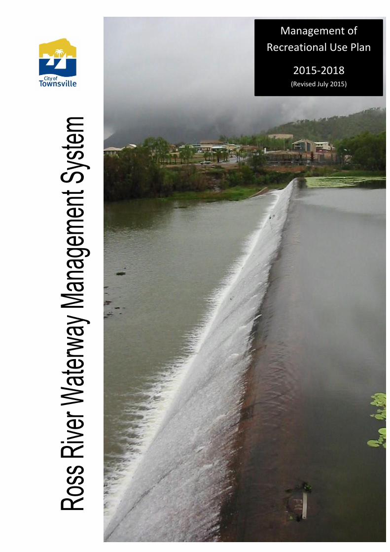
Management of
Recreational Use Plan
2015-2018 (Revised July 2015)
Traditional Owners
Townsville City Council acknowledges the Aboriginal Traditional Owners of the plan area.
This Document
This document sets out arrangements for the management of the use of the Townsville City Council
controlled sections of the Ross River in the city of Townsville, Queensland, Australia.
Acknowledgements
Townsville City Council wishes to acknowledge all the individuals and organisations that assisted in
the preparation of this document and in particular Connell-Wagner for their work in preparing the
preceding documentation upon which it is based – the 2005 Ross River Waterway Management
System.
Executive Summary
Background
The Ross River is a significant natural feature of Queensland’s most densely populated regional
urban centre, Townsville. There are a number of pressures impacting the river, which require
management and/or intervention to ensure that the waterway and its adjacent environs are not
detrimentally affected. To achieve the management of this waterway, Townsville City Council has
developed the Ross River Waterway Management System for the section of the Ross River
between Ross Dam and Aplin’s Weir.
Components of the Ross River Waterway Management System are:
The Strategy - A framework for integrated waterway management for the freshwater sections of the
Ross River (a waterway management strategy), including for sustainable recreation;
The Plans - Management plans for significant elements & issues identified in the Strategy, one of
which is this document – the Management of Recreational Use Plan.
Document History
Revised: June 2013, June 2015 (current)
Objectives
The objectives of the Ross River Waterway Management System are:
• Provision of a framework for integrated waterway management of the freshwater sections of
the Ross River;
• Identification of issues, objectives and specific actions for conducting management works;
• Provision of guidelines for waterway management to achieve recreational usage consistent
with sustainable
• natural resource management principles and practice.
Existing Plans, Legislation and Studies
Existing management plans for the Ross River include:
• Commonwealth, State and Local Government Legislation and Regulations;
• Ross River Recreation Masterplan;
• Ross River Parkway: A Natural Seam In The City Landscape Masterplan Final Report;
• Riverway Master Plan Stage 1: Pioneer Park and Loam Island;
• City Council Planning Schemes;
• Urban Storm Water Quality Management Plans (USQMPs)
• Pest Management Plans; and
• Open Space for Sport & Recreation Guidelines - Queensland Dept of Sport and Recreation.
What Impacts on the Ross River Waterway?
A summary of the issues and activities that impact on the Ross River Waterway includes:
• Weirs and the Ross River Dam;
• Private ownership;
• Recreational activities;
• Watercraft access nodes & usage areas;
• Municipal and commercial uses;
• Land development;
• Urban, commercial, industrial, & road storm water;
• Introduced plants and animals;
• Fish stocking.
Drivers and Mechanisms for Management of the Waterway
The drivers of any management process are generally diverse, and include matters that are
required by legislation, policy existing outside regulatory requirements, and voluntary initiatives
arising from community concern or expectations. Drivers usually have political, economic,
social, cultural and environmental components in varying degrees. The mechanisms for
delivering management outcomes are partly dependent on the drivers as well as practical
considerations for implementation e.g. risks associated with doing nothing.
For the Ross River, drivers and mechanisms for management of the waterway include
• Commonwealth, State and Local Government legislation, regulations and requirements
• Council’s Role and Responsibilities;
• Community Based Regional NRM Planning;
• Open Space for Sport & Recreation;
• Creek to Coral initiative;
• Landcare and other community groups;
• Public perception and expectations; and
• Commercial considerations.
Environmental Conditions
Existing land use along the Ross River waterway includes:
• Parks and open space (Council);
• Natural or remnant environment (Department of Natural Resources and Mines);
• Military Training Area (Defence);
• Water Treatment;
• Roads and infrastructure (Dept of Main Roads);
• Residential (Individuals);
There are sections of the river in which there is substantial remnant vegetation remaining that has
not been significantly disturbed. The main stretch of natural environment borders the Mt Stuart Field
Training Area and upper reaches of the study area. Most of this land is Unallocated State Land
(USL). The land consists of the bed and banks of the river, associated tributaries and riparian
zones.
There are a number of minor remnant vegetation patches further downstream where constraints
have prevented the establishment of formal parkland. The areas are not pristine and have been
subjected to some form of disturbance. The main issue associated with these areas is
encroachment and spread of exotic plant species and pest animals.
Detrimental impacts (sediment, erosion and litter) from land development, road construction and
urban runoff have been identified on the river. The level of impacts varies from minimal to
significant. Aquatic weeds are also a significant environmental management issue on the Ross
River.
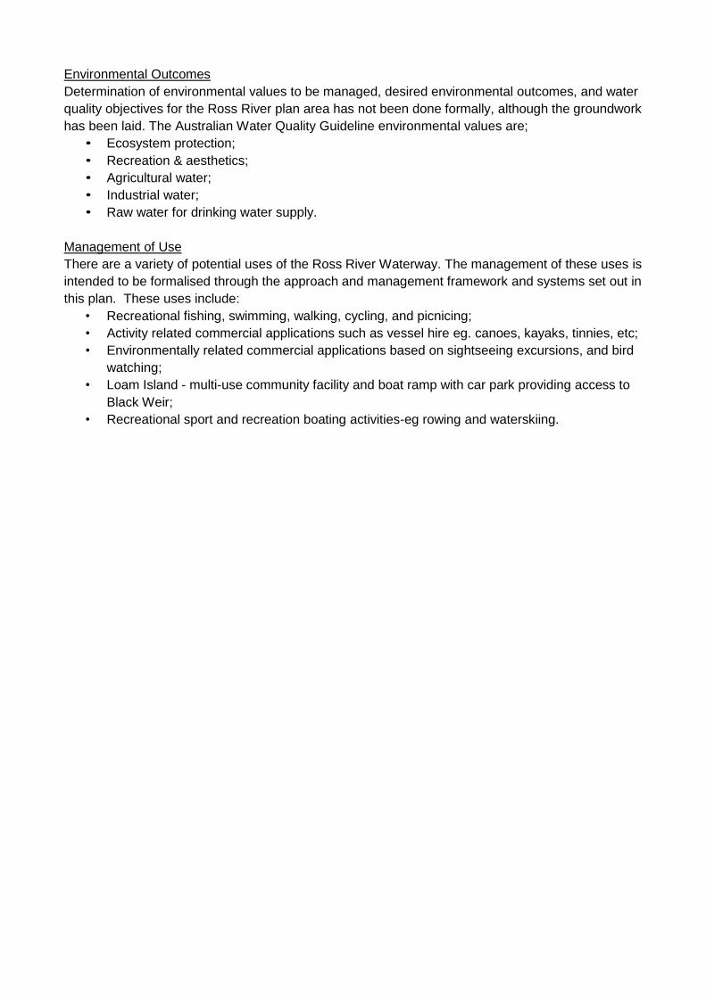
Environmental Outcomes
Determination of environmental values to be managed, desired environmental outcomes, and water
quality objectives for the Ross River plan area has not been done formally, although the groundwork
has been laid. The Australian Water Quality Guideline environmental values are;
• Ecosystem protection;
• Recreation & aesthetics;
• Agricultural water;
• Industrial water;
• Raw water for drinking water supply.
Management of Use
There are a variety of potential uses of the Ross River Waterway. The management of these uses is
intended to be formalised through the approach and management framework and systems set out in
this plan. These uses include:
• Recreational fishing, swimming, walking, cycling, and picnicing;
• Activity related commercial applications such as vessel hire eg. canoes, kayaks, tinnies, etc;
• Environmentally related commercial applications based on sightseeing excursions, and bird
watching;
• Loam Island - multi-use community facility and boat ramp with car park providing access to
Black Weir;
• Recreational sport and recreation boating activities-eg rowing and waterskiing.
Table of Contents
Section Page
1. Introduction 1
1.1 Background 1
1.2 Objectives 1
1.3 The Need 1
2. Planning Activities 3
2.1 Background 3
3. Summary of Background Information 4
3.1 Background 4
3.2 Legislation 4
3.3 Issues and Influences 4
3.4 Tenure and Management Responsibilities 6
3.5 Land Use 7
4. Planning for Management of the Ross River Waterway 14
4.1 Introduction 14
4.2 Management Objectives 14
4.3 Black Weir Pool 14
4.4 Aplin’s and Gleeson's Weir Pools 15
4.5 Indigenous Issues and Management 15
4.6 Riparian Area Management 15
4.7 Aquatic Weed Management 15
4.8 Integrated Stormwater Management 15
4.9 Ongoing and Future Activities 16
5. Management Objectives 17
5.1 Environmental Management 17
5.2 Water Quality Management 18
5.3 Recreational Use Management 23
6. Management Planning Consultation 23
6.1 Introduction 23
6.2 Black Weir 23
6.3 Aplin’s and Gleeson's Weirs 28
6.4 Riparian Zones 31
6.5 Aquatic Weed Management 33
7. Management Plans and Actions 34
7.1 General Comments 34
7.2 Governance, Communication and Awareness 34
7.3 Condition Assessment 35
7.4 Cultural Heritage 35
7.5 Management Objectives 35
7.6 Riparian Management 36
7.7 Aquatic Weed Management 36
7.8 Stormwater Management 36
7.9 Aplin’s and Gleeson's Weirs 36
7.10 Black Weir 36
8. Evaluation and Enforcement 41
8.1 Evaluation 41
8.2 Enforcement 41
8.3 Review 42
Section Page
9. Future Investigation and Potential Development 42
Appendix A
Ross River Waterway Management System Strategic Management Areas 43
Appendix B
Open Space for Sport and Recreation 44
Appendix C
Traditional Owner Contact Details 47
Appendix D
Stage 2 Consultation Summary Information 48
Appendix E
Revised Management of Recreational Use 49
Appendix F
Statement of Principles – Use of Black Weir 55
Appendix G
Draft Local Law 58
Figures
Figure 1-1 Black Weir 1
Figure 1-2 Plan Area 2
Figure 3-1 Schematic diagram of Ross River weirs 10
Figure 6-1 Current Use Zones for Black Weir 24
Figure 6-2 Aplin’s and Gleeson's Weir Pools 30
Figure 7-1 Current Black Weir Recreational Use Zones 40
Figure A Recreational Use Zones 50
Tables
Table 2-1 Management/Planning Activities 3
Table 3-1 Tenure of the Study Area 6
Table 3-2 Parks and Open Space Use and Management 7
Table 3-3 Significant Re-vegetation Sites 9
Table 3-4 Summary of institutional arrangements 11
Table 4-1 Ongoing and Potential Activities 17
Table 5-1 Implied values of the Ross River study area 17
Table 5-2 Environmental Values 20
Table 5-3 Water Quality Guidelines 21
Table 5-4 Water Quality Objectives 22
Table 7-1 Current Black Weir Recreational Use Zones 37
Table 7-2 Revised Black Weir Recreational Use Management Actions 40
Table A Revised Management of Recreational Use Zones – Black Weir 51
1
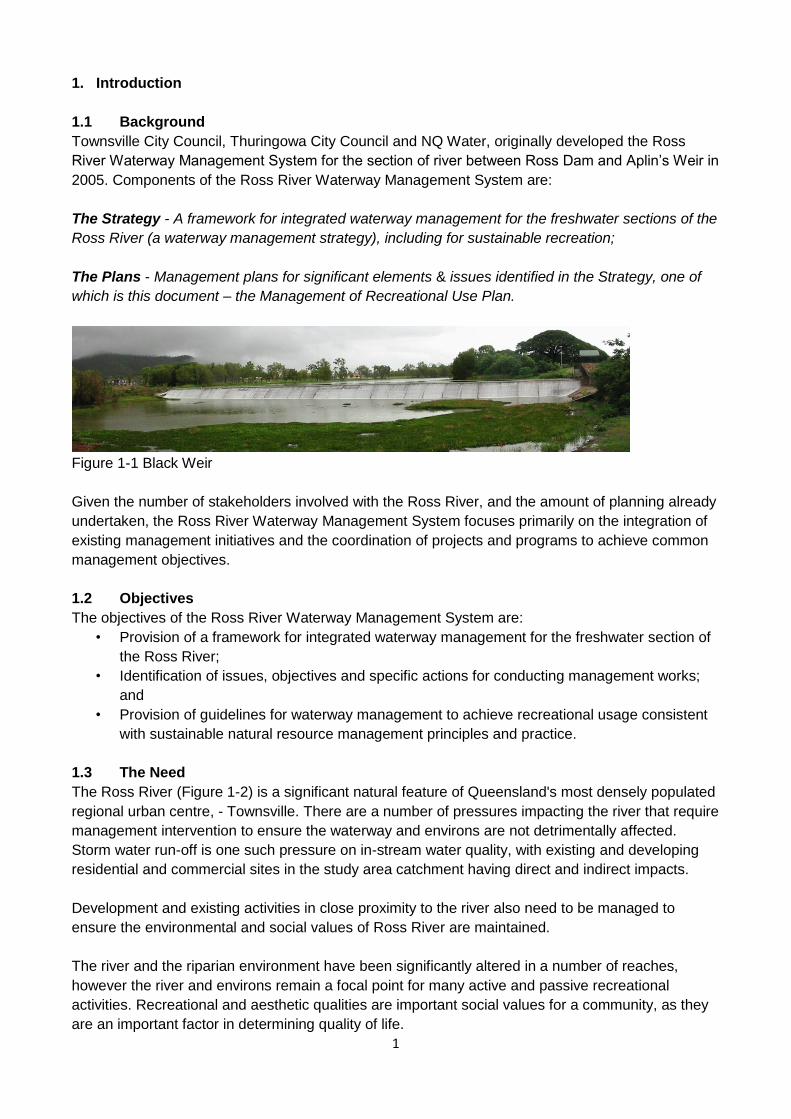
1. Introduction
1.1 Background
Townsville City Council, Thuringowa City Council and NQ Water, originally developed the Ross
River Waterway Management System for the section of river between Ross Dam and Aplin’s Weir in
2005. Components of the Ross River Waterway Management System are:
The Strategy - A framework for integrated waterway management for the freshwater sections of the
Ross River (a waterway management strategy), including for sustainable recreation;
The Plans - Management plans for significant elements & issues identified in the Strategy, one of
which is this document – the Management of Recreational Use Plan.
Figure 1-1 Black Weir
Given the number of stakeholders involved with the Ross River, and the amount of planning already
undertaken, the Ross River Waterway Management System focuses primarily on the integration of
existing management initiatives and the coordination of projects and programs to achieve common
management objectives.
1.2 Objectives
The objectives of the Ross River Waterway Management System are:
• Provision of a framework for integrated waterway management for the freshwater section of
the Ross River;
• Identification of issues, objectives and specific actions for conducting management works;
and
• Provision of guidelines for waterway management to achieve recreational usage consistent
with sustainable natural resource management principles and practice.
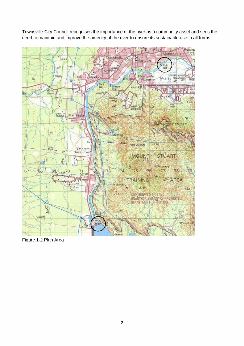
1.3 The Need
The Ross River (Figure 1-2) is a significant natural feature of Queensland's most densely populated
regional urban centre, - Townsville. There are a number of pressures impacting the river that require
management intervention to ensure the waterway and environs are not detrimentally affected.
Storm water run-off is one such pressure on in-stream water quality, with existing and developing
residential and commercial sites in the study area catchment having direct and indirect impacts.
Development and existing activities in close proximity to the river also need to be managed to
ensure the environmental and social values of Ross River are maintained.
The river and the riparian environment have been significantly altered in a number of reaches,
however the river and environs remain a focal point for many active and passive recreational
activities. Recreational and aesthetic qualities are important social values for a community, as they
are an important factor in determining quality of life.
2
Townsville City Council recognises the importance of the river as a community asset and sees the
need to maintain and improve the amenity of the river to ensure its sustainable use in all forms.
Figure 1-2 Plan Area
3
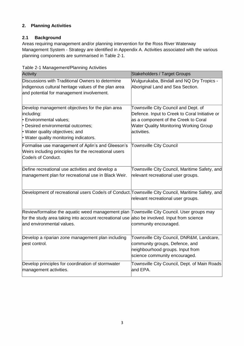
2. Planning Activities
2.1 Background
Areas requiring management and/or planning intervention for the Ross River Waterway
Management System - Strategy are identified in Appendix A. Activities associated with the various
planning components are summarised in Table 2·1.
Table 2-1 Management/Planning Activities
Activity Stakeholders / Target Groups
Discussions with Traditional Owners to determine
indigenous cultural heritage values of the plan area
and potential for management involvement.
Wulgurukaba, Bindall and NQ Dry Tropics -
Aboriginal Land and Sea Section.
Develop management objectives for the plan area
including:
• Environmental values;
• Desired environmental outcomes;
• Water quality objectives; and
• Water quality monitoring indicators.
Townsville City Council and Dept. of
Defence. Input to Creek to Coral Initiative or
as a component of the Creek to Coral
Water Quality Monitoring Working Group
activities.
Formalise use management of Aplin’s and Gleeson’s
Weirs including principles for the recreational users
Code/s of Conduct.
Townsville City Council
Define recreational use activities and develop a
management plan for recreational use in Black Weir.
Townsville City Council, Maritime Safety, and
relevant recreational user groups.
Development of recreational users Code/s of Conduct. Townsville City Council, Maritime Safety, and
relevant recreational user groups.
Review/formalise the aquatic weed management plan
for the study area taking into account recreational use
and environmental values.
Townsville City Council. User groups may
also be involved. Input from science
community encouraged.
Develop a riparian zone management plan including
pest control.
Townsville City Council, DNR&M, Landcare,
community groups, Defence, and
neighbourhood groups. Input from
science community encouraged.
Develop principles for coordination of stormwater
management activities.
Townsville City Council, Dept. of Main Roads
and EPA.
4
3. Summary of Background Information
3.1 Background
The Ross River Waterway Management System Strategy identified and described:
• Factors impacting the study area;
• Management drivers and mechanisms influencing the study area;
• The existing environment;
• Future uses of the waterway and near environs; and
• A framework for integrated management arrangements.
Information relevant to the management planning is summarised in this section and provides
background information for the planning activities mentioned in Section 2.
3.2 Legislation
The following legislation has been identified as having an impact on the Ross River plan area and
management decisions:
• Environment Protection and Biodiversity Conservation Act 1999 (EPBC Act or EPBCA);
• State Development and Public Works Organisation Act 1971;
• Transport Infrastructure Act 1994;
• Transport Operations (Road Use Management) Act 1995;
• Integrated Planning Act 1997;
• Townsville City Council (Douglas Land Development) Act 1993;
• Local Government Act 2009;
• Environmental Protection Act 1994;
• Environmental Protection (Water) Policy 2009;
• Fisheries Act 1994;
• Fisheries Management (Freshwater) Plan 1999;
• Water Act 2000;
• Transport Operations (Marine Safety) Act 1994;
• Vegetation Management Act 1999 (And Land Act);
• Nature Conservation Act 1992; and
• Land Protection (Pest and Stock Route Management) Act 2002.
A variety of legislation applies to waterways and surrounds which influences management
responsibilities and requirements. In practice, each situation needs to be interpreted on an
individual basis whilst being mindful of the interrelationships with adjoining areas, assets and
activities. Where a waterway system is involved, management responsibility can appear less
demarcated due to the seeming overlap of responsibility, or conversely, to the lack of definition of
responsibility and, in some cases, the lack of specificity of policy or legislation to a situation.
3.3 Issues and Influences
The main issues and influences on the management of the Ross River plan area are discussed
briefly below. A comprehensive list of the issues identified from literature reviews and consultation is
included in the Strategy document.
Upgrade of Ross River Dam
The dam upgrade program, which was completed in 2007, involved lowering the spillway, fitting flow
gates, installing sand filters and supporting earth fill, augmenting wave-protecting rockwork and
associated works.
5
The upgrade is not expected to have any major influence on the Ross River and will provide for
greater flow control and retention capacity in the event of a significant wet season.
Roads
Most sections of the study area do not have sealed roads running 'parallel' with the river. The
notable exception is the Riverway Drive from Gregory Street, Condon to Allambie Lane, Kelso.
Whilst storm water runoff from any sealed road has potential to add pollutants to the storm water
drainage system and subsequently to receiving waters, the potential impact is greater where the
distance between roads and receiving waters is negligible i.e. there is little chance for pollutants to
be 'filtered' out, settle or be adsorbed before reaching receiving waters. Storm water systems are
the main link between roads and the river and require further consideration in that context.
The Douglas Arterial Road has had some impact on the Ross River at the bridge abutments. The
bridge will have an ongoing influence on waterway activities.
Electrical Power Lines
Electrical power lines cross the river in three locations and are not seen as a significant influence on
river management under most circumstances.
Residential Areas
Residential areas are generally set back from the river and have parks and open space and/or
roads between them and the river. The main exceptions are the stretches of river between Allambie
Lane, Kelso, and Ross Dam Park, and in the vicinity of Moondarga Drive, Cranbrook, above
Gleeson's Weir, where residential blocks adjoin the river
The lineal open space network is interrupted in these areas and raises some issues regarding
management of riparian areas and public access versus private rights.
Residential Development
The main residential development influencing the study area is at Douglas (Riverside Gardens). It is
a unique situation as the development proceeds under a specific piece of State legislation and is
outside 'normal' development planning and assessment processes.
Public consultation identified the loss of riverside vegetation as a major concern associated with the
development. There are also issues associated with construction activities especially sediment and
erosion control. Ongoing influences will include expectations of residents with respect to activities in
the surrounding environment, including Ross River.
Riverway and Ross River Parkway
These are projects of Townsville City Council and are shaping the use and management of the land
adjacent to the river and are subject to studies and environmental management plans designed to
minimise detrimental impacts on the river.
Recreation
Ross River holds special values within the community of Townsville. The river provides for a range
of recreational activities for residents and for visitors to the region. Recreational activities associated
with Ross River include those that physically occur within the river, and those that take advantage of
6
the amenity and scenic values that the river offers. Popular recreational uses incorporate both
passive and active recreation and include:
• Cycling/Walking/Jogging
• Swimming
• Picnics/Barbecues
• Fishing
• Triathlon events
• Quiet Relaxation
• Canoeing/Rowing/Kayaking
• Power boating
• Waterskiing
• Cultural events
Department of Defence Training Activities
The Department of Defence uses the river adjacent to the Mt Stuart Field Training Area (MSTA) for
activities such as:
• River crossing training (approximately four times a year);
• Water training;
• Canoeing; and
• Diving (once per 12-18 months).
These activities are accompanied by guidelines and protocols, which adequately manage
environmental and socio-economic impacts.
Aquatic Weeds
Townsville City Council Maintenance Services engage Townsville Water to undertake aquatic weed
control in all three weirs as part of a whole of catchment approach to management. This
management role results in social and environmental benefits for recreational users and the broader
community. Weed control also contributes to Black Weir’s capability of delivering adequate raw
water quality to enable treatment to the standards required by the Australian Drinking Water
Guidelines (NHMRC and ANZECC 1996) when required.
3.4 Tenure and Management Responsibilities
The main owners or managers of the Ross River and its environs are listed Table 3·1.
Table 3-1 Tenure of the Plan Area
Owner / Administrator / Manager
Land / Asset location and (legislative power)
State of Queensland (Dept. of Energy
& Water Supply)
Beds and banks of waterways measured to the high bank
Townsville Water
Land in the vicinity of Ross Dam and impounded water.
Townsville City Council Black, Gleeson’s and Aplin’s Weirs and impounded water.
Townsville City Council Property adjacent to the river above the high bank
Individuals Property adjacent to the river Allambie Lane to Ross Dam
Park (north bank).
Townsville Water
Property adjoining the Douglas Water Treatment Plant.
Dept. of Defence - Commonwealth of
Australia
Property adjacent to the river from the Water Treatment
Plant to Ross Dam (south bank)
7
In general, the management of the land and associated assets is the responsibility of the landowner
whether that is an individual, a company, local government, State Government or a Commonwealth
Government agency.
3.5 Land Use
The main land uses adjoining the river are:
• Parks and open space (Townsville City Council);
• Natural or remnant environment (Department of Natural Resources and Mines);
• Military Training Area (Dept. of Defence);
• Water Treatment (Townsville Water);
• Roads and infrastructure (Department of Main Roads);
• Residential (individuals).
Parks and Open Space
This broad land use category encompasses a range of characteristics and associated uses as
outlined in Table 3·2.
Table 3-2 Parks and Open Space Use and Management
Type of land
use
Description Management Arrangements
Formalised
open space
Planted areas, often with exotic species,
with lawns and defined borders.
Constructed and maintained by
departments of local government.
Some parks may have been
established by service clubs such as
Apex and Rotary, or by developers by
arrangement with Council.
Playing fields Sports fields and ovals, essentially
consisting of grassed open space.
Generally constructed and maintained
by Infrastructure Services department
of Council and sporting clubs.
Walking paths Paved, concreted, bitumen or other formed
walking paths and tracks. Informal walking
paths also exist and are typically worn
areas traversing open space where formal
tracks do not exist.
Generally constructed and maintained
by Infrastructure Services department
of Council. Some constructed by
developers by arrangement with
Council.
Bikeways Paved, concreted, bitumen or other formed
pathways for bicycle use. As with walking
paths informal bike paths exist. Dual
bikeways/walking paths are common due to
the expense of constructing and maintaining
two separate systems.
Generally constructed and maintained
by Infrastructure Services department
of Council. Also constructed by
developers by arrangement with
Council.
8
Facilities and
furniture
This is a broad category covering all the
non-natural features installed for recreation,
safety and amenity purposes. Includes
seating, tables, barbecues, play equipment,
toilets, signage, bollards and other barriers,
viewing platforms, fishing platforms and
ship (boats, canoes etc) launching facilities.
Usually constructed and maintained by
Infrastructure Services department of
council but may also be installed by
developers, service clubs, community
groups, commercial operators or
individuals, by arrangement with
Council and/or other relevant authority.
Riparian areas The section between the water and the high
bank, which depending on the topography,
may be left untended or incorporate some
elements of other parks and open space
land use categories, usually with the
exception of formal parkland and playing
fields , and structures susceptible to flood
damage.
Depending on the situation areas may
be unmanaged or maintained by
Council (Infrastructure Services and/or
Integrated Sustainability Services
departments - natural area
management teams), community
groups, developers, individual land
owners.
Re-vegetation
sites
Usually sections of the riparian zone where
the original vegetation has been removed or
degraded and a need is seen
to restore the area using native vegetation
endemic to the site.
Generally instigated by community
groups, often supported by and in
conjunction with local government.
Council approval, or approval of the
relevant landowner, is required prior to
commencement of works.
Maintenance is carried out by
community group members and other
volunteers, and Council natural area
management teams, sometimes with
additional labour supplied by training
programs including; Green Corps,
Community Jobs Plan and Work for
the Dole. In some cases, Councils
TCC Maintenance Services
department, maintain sites in
conjunction with natural area teams
and community.
Natural areas These are areas that are relatively
undisturbed associated with the upper
reaches of the Ross River study area
generally in the region between property
boundaries on either side of the river where
there is no continuous expanse of water,
and between property boundaries and the
river in other areas.
Relatively unmanaged with the
exception of perceived strategically
important areas such as Corveth’s
Waterhole where community group
activity and activity supported by
community groups and Councils is
carried out on a semi-regular basis i.e.
incorporated in non-continuous and
separate projects.

9
Access areas Open space, tracks or roadways maintained
to enable access to the river, facilities or
other areas for recreation purposes and to
enable management and maintenance
operations to be carried out.
Identified in planning processes to
facilitate ongoing management
activities and recreational access.
Areas usually physically managed by
Councils and also maintained in their
planning documents and processes.
Parking areas Dedicated areas for vehicle parking by
visitors to the river environs.
As for access areas.
Clubhouse and
equipment
storage
facilities
These are usually setback from the
waterway to avoid any flooding associated
issues. These are usually owned or
occupied by organisations using the river
and environs for recreational purposes such
as rowing and canoeing clubs. May be
housed with maintenance facilities.
Management depend on the facility
owner and arrangements made
between the facility owner and the
user, if separate entities. Management
and maintenance may be a function of
Councils, clubs or community
organisations, or some combination of
these.
Maintenance
facilities
As with clubhouse and equipment storage
facilities these are usually situated in areas
where flooding is not a problem. Usually
associated with park maintenance and may
consist of a compound with maintenance
equipment e.g. mowers, and stockpiles of
materials such as mulch and topsoil.
Managed and operated by Councils.
May have some arrangements with
community groups or other
organisations for storage and or co-
use of equipment or facilities.
Parks/open space land use include the flagship amenities of Townsville City Council:
• Riverway, and
• Ross River Parkway.
Townsville City Council contributes to the Landcare Strategic Re-vegetation Project, which provides
support to community neighbourhood groups carrying out re-vegetation works in their local areas.
Significant re-vegetation sites are listed in Table 3-3.
Table 3-3 Significant Re-vegetation Sites
Site
Works
Participants
Harmony Park, near Black Weir Re-vegetation Weir State School
Park below Black Weir Re-vegetation Work for the Dole, and
Wet Tropics Reforestation Program
Loam Island Weed
clearing/control
and re-vegetation
Work for the Dole team/s
Corveth’s Waterhole, downstream
of Ross Dam
Weed control and
supplementary
planting
Green Corps, and Landcare Strategic
Re-vegetation Project
Bushgarden, near Aplin’s
Weir
Re-vegetation Townsville Urban Production and Landcare
Group (TUPALG)
Kirrang Court Re-vegetation Landcare Strategic Re-vegetation Project
10
Marabou Court Re-vegetation Landcare Strategic Re-vegetation Project
Endeavour Creek Re-vegetation Landcare Strategic Re-vegetation Project
Isabella Court Re-vegetation Landcare Strategic Re-vegetation Project
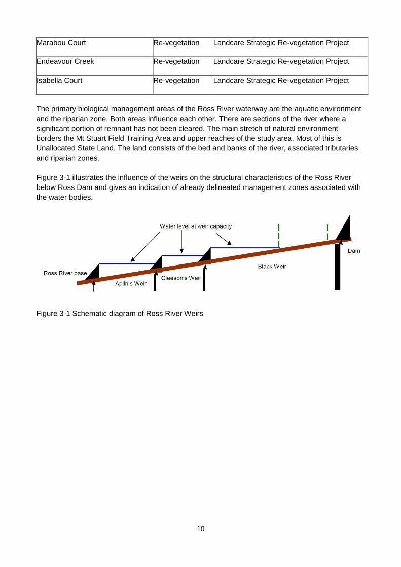
The primary biological management areas of the Ross River waterway are the aquatic environment
and the riparian zone. Both areas influence each other. There are sections of the river where a
significant portion of remnant has not been cleared. The main stretch of natural environment
borders the Mt Stuart Field Training Area and upper reaches of the study area. Most of this is
Unallocated State Land. The land consists of the bed and banks of the river, associated tributaries
and riparian zones.
Figure 3-1 illustrates the influence of the weirs on the structural characteristics of the Ross River
below Ross Dam and gives an indication of already delineated management zones associated with
the water bodies.
Figure 3-1 Schematic diagram of Ross River Weirs
11
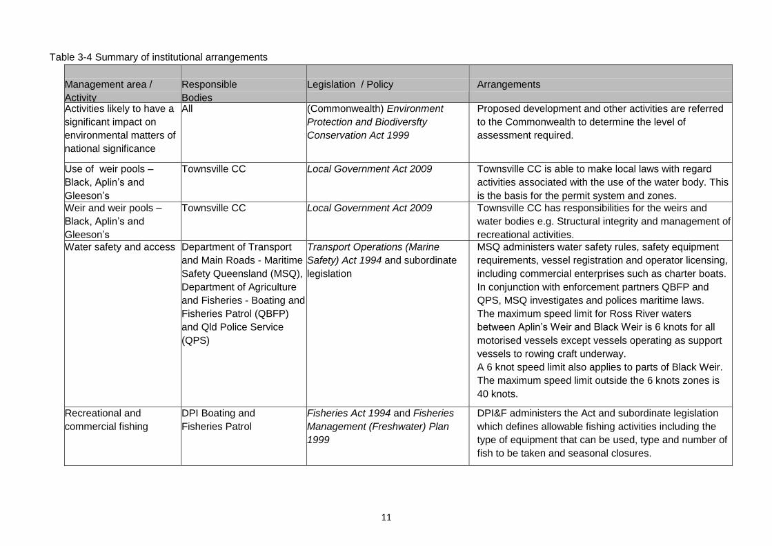
Table 3-4 Summary of institutional arrangements
Management area /
Activity
Responsible
Bodies
Legislation / Policy
Arrangements
Activities likely to have a
significant impact on
environmental matters of
national significance
All (Commonwealth) Environment
Protection and Biodiversfty
Conservation Act 1999
Proposed development and other activities are referred
to the Commonwealth to determine the level of
assessment required.
Use of weir pools –
Black, Aplin’s and
Gleeson’s
Townsville CC Local Government Act 2009 Townsville CC is able to make local laws with regard
activities associated with the use of the water body. This
is the basis for the permit system and zones.
Weir and weir pools –
Black, Aplin’s and
Gleeson’s
Townsville CC Local Government Act 2009 Townsville CC has responsibilities for the weirs and
water bodies e.g. Structural integrity and management of
recreational activities.
Water safety and access Department of Transport
and Main Roads - Maritime
Safety Queensland (MSQ),
Department of Agriculture
and Fisheries - Boating and
Fisheries Patrol (QBFP)
and Qld Police Service
(QPS)
Transport Operations (Marine
Safety) Act 1994 and subordinate
legislation
MSQ administers water safety rules, safety equipment
requirements, vessel registration and operator licensing,
including commercial enterprises such as charter boats.
In conjunction with enforcement partners QBFP and
QPS, MSQ investigates and polices maritime laws.
The maximum speed limit for Ross River waters
between Aplin’s Weir and Black Weir is 6 knots for all
motorised vessels except vessels operating as support
vessels to rowing craft underway.
A 6 knot speed limit also applies to parts of Black Weir.
The maximum speed limit outside the 6 knots zones is
40 knots.
Recreational and
commercial fishing
DPI Boating and
Fisheries Patrol
Fisheries Act 1994 and Fisheries
Management (Freshwater) Plan
1999
DPI&F administers the Act and subordinate legislation
which defines allowable fishing activities including the
type of equipment that can be used, type and number of
fish to be taken and seasonal closures.
12
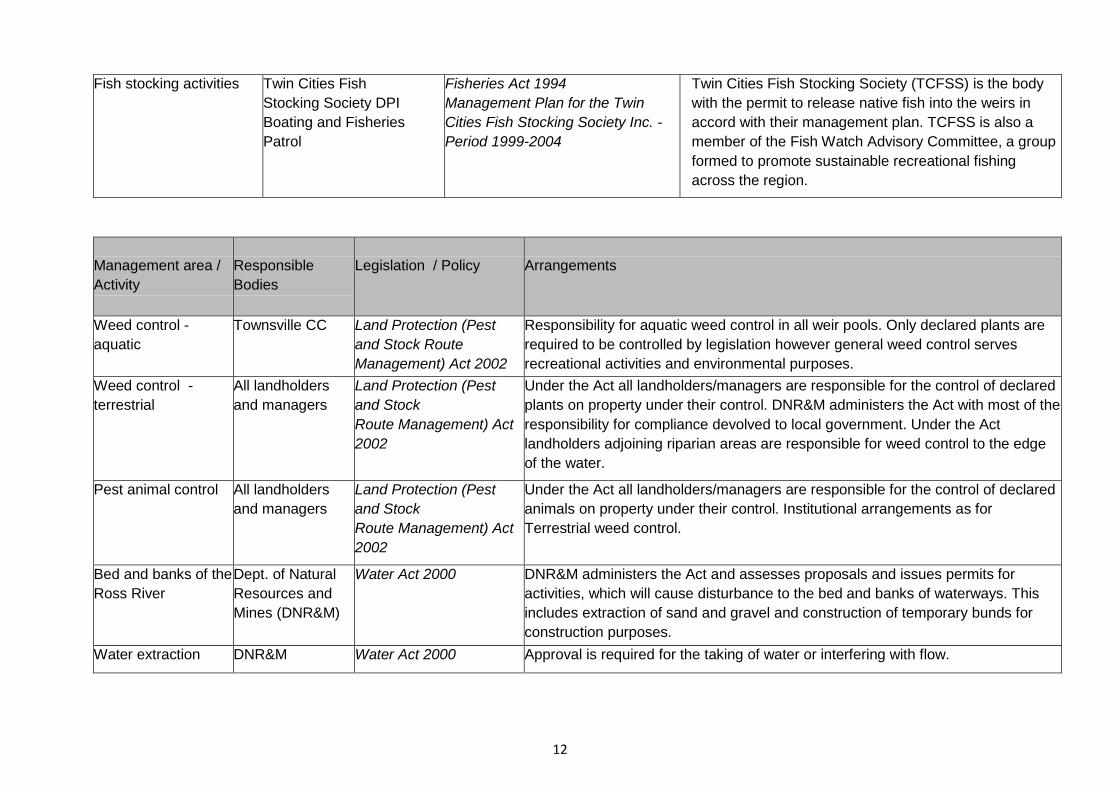
Fish stocking activities Twin Cities Fish
Stocking Society DPI
Boating and Fisheries
Patrol
Fisheries Act 1994
Management Plan for the Twin
Cities Fish Stocking Society Inc. -
Period 1999-2004
Twin Cities Fish Stocking Society (TCFSS) is the body
with the permit to release native fish into the weirs in
accord with their management plan. TCFSS is also a
member of the Fish Watch Advisory Committee, a group
formed to promote sustainable recreational fishing
across the region.
Management area /
Activity
Responsible
Bodies
Legislation / Policy
Arrangements
Weed control -
aquatic
Townsville CC Land Protection (Pest
and Stock Route
Management) Act 2002
Responsibility for aquatic weed control in all weir pools. Only declared plants are
required to be controlled by legislation however general weed control serves
recreational activities and environmental purposes.
Weed control -
terrestrial
All landholders
and managers
Land Protection (Pest
and Stock
Route Management) Act
2002
Under the Act all landholders/managers are responsible for the control of declared
plants on property under their control. DNR&M administers the Act with most of the
responsibility for compliance devolved to local government. Under the Act
landholders adjoining riparian areas are responsible for weed control to the edge
of the water.
Pest animal control All landholders
and managers
Land Protection (Pest
and Stock
Route Management) Act
2002
Under the Act all landholders/managers are responsible for the control of declared
animals on property under their control. Institutional arrangements as for
Terrestrial weed control.
Bed and banks of the
Ross River
Dept. of Natural
Resources and
Mines (DNR&M)
Water Act 2000 DNR&M administers the Act and assesses proposals and issues permits for
activities, which will cause disturbance to the bed and banks of waterways. This
includes extraction of sand and gravel and construction of temporary bunds for
construction purposes.
Water extraction DNR&M Water Act 2000 Approval is required for the taking of water or interfering with flow.
13
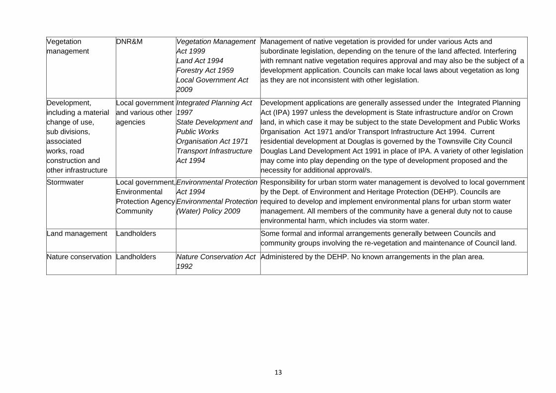
Vegetation
management
DNR&M Vegetation Management
Act 1999
Land Act 1994
Forestry Act 1959
Local Government Act
2009
Management of native vegetation is provided for under various Acts and
subordinate legislation, depending on the tenure of the land affected. Interfering
with remnant native vegetation requires approval and may also be the subject of a
development application. Councils can make local laws about vegetation as long
as they are not inconsistent with other legislation.
Development,
including a material
change of use,
sub divisions,
associated
works, road
construction and
other infrastructure
Local government
and various other
agencies
Integrated Planning Act
1997
State Development and
Public Works
Organisation Act 1971
Transport Infrastructure
Act 1994
Development applications are generally assessed under the Integrated Planning
Act (IPA) 1997 unless the development is State infrastructure and/or on Crown
land, in which case it may be subject to the state Development and Public Works
0rganisation Act 1971 and/or Transport Infrastructure Act 1994. Current
residential development at Douglas is governed by the Townsville City Council
Douglas Land Development Act 1991 in place of IPA. A variety of other legislation
may come into play depending on the type of development proposed and the
necessity for additional approval/s.
Stormwater Local government,
Environmental
Protection Agency
Community
Environmental Protection
Act 1994
Environmental Protection
(Water) Policy 2009
Responsibility for urban storm water management is devolved to local government
by the Dept. of Environment and Heritage Protection (DEHP). Councils are
required to develop and implement environmental plans for urban storm water
management. All members of the community have a general duty not to cause
environmental harm, which includes via storm water.
Land management Landholders Some formal and informal arrangements generally between Councils and
community groups involving the re-vegetation and maintenance of Council land.
Nature conservation Landholders Nature Conservation Act
1992
Administered by the DEHP. No known arrangements in the plan area.
14
4. Planning for Management of the Ross River Waterway
4.1 Introduction
Management planning has been a two-stage process commencing with the investigation of the
issues and development of the Ross River Waterway Management Strategy in the first stage. The
development of management plans and/or frameworks builds on the first stage and have been done
through consultation with the landholders/managers of Ross River and the adjacent lands (refer to
Section 6). The main management areas and issues to be addressed for each management area
are discussed below.
4.2 Management Objectives
Management objectives will be determined individually for each of the management areas as part of
the planning and consultation process. Management objectives for the overall study area are
discussed in Section 5.
4.3 Black Weir Pool
The management of Black Weir pool has become more complex as development has extended
upstream. While Townsville City Council is the manager of both the weir pool and the weir, the
management responsibilities and activities of Townsville City Council, and other adjoining
landholders/managers, must be considered when developing management arrangements.
The Townsville City Council management of the use of these weir pools is a key component of the
management of Ross River. Development of recreational users' Code/s of Conduct, and Local
Laws, consistent with Council's management of use are actions arising from the development of the
management of use framework that this document presents.
Townsville Water and the Douglas Water Treatment Plant
Townsville City Council is the owner/manager of Black Weir and the water body (weir pool)
contained by the weir. The Black Weir remains as an emergency water supply storage in the event
that water from Ross Dam is not available. At capacity there is enough water behind Black Weir to
supply the water needs of Townsville, via the Douglas water Treatment Plant, for approximately two
weeks. The pump used for emergency water supply is located adjacent to the water treatment plant.
The Douglas Water Treatment Plant (DWTP) occupies a relatively small section of the riverbank
upstream of Black Weir. It is the major water treatment and storage plant and a key asset in the
water supply system for Townsville. The water travels 9.2 kilometres from Ross River Dam to the
DWTP, in a 1.22m diameter concrete pipe. On average the DWTP treats 150ML of water daily, up
to 230ML a day.
Environmental compliance is generally limited to the discharge of backwash water to the river, which
is subject to a permit issued by the EPA. Water used to backwash filters at the treatment plant
has traditionally been released to Ross River helping maintain water levels in Black Weir.
Townsville Water is implementing infrastructure upgrades to achieve zero discharge in the future,
with the exception of extraordinary circumstances, in compliance with Environmental Protection
Agency requirements defining new operating procedures.
Recreation
Construction of the Douglas Arterial Road Bridge and development of the Riverway project has
altered the recreational profile of the river and is the catalyst for revision of past use management
arrangements.
15
4.4 Aplin’s and Gleeson's Weir Pools
The responsibility for Gleeson's Weir and Aplin’s Weir, and the associated water bodies, was
handed over to Townsville City Council in 2001. As they are not required for water supply, it is
appropriate for Townsville City Council to manage these weirs and their surrounding areas.
The Townsville City Council management of the use of these weir pools is a key component of the
management of Ross River. Development of recreational users' Code/s of Conduct, and Local
Laws, consistent with Council's management of use, are actions arising from the development of
the management of use framework that this document presents.
4.5 Indigenous Issues and Management
The indigenous Traditional Owners currently have limited involvement in the management of Ross
River. The indigenous cultural heritage values associated with the river are also relatively unknown
as no specific literature was discovered during the course of this study. Some determination of the
role Traditional Owners would like to play in the future management of the river is required in
association with an assessment of the cultural heritage values of the waterway and adjacent lands.
4.6 Riparian Area Management
Management of the riparian zone includes:
• Maintenance of existing parks;
• Pest control, both animal and plant;
• Re-vegetation and management of natural areas;
• Construction of new facilities; and
• Ensuring access to the river for recreational and management purposes.
To enable the management of these elements it is useful to divide the riparian area into a number of
management zones. Proposed management zones are:
• Black Weir Natural Areas (includes Dept. of Defence land);
• Residential development (Riverside Gardens);
• Townsville City Council property, parklands and adjacent riverbanks (includes Riverway);
• Douglas Water Treatment Plant.
4.7 Aquatic Weed Management
Management of exotic and native aquatic plants is an ongoing issue due to the altered nature of the
waterway and the abundance of introduced plant species. Part of the management planning
process involves a review of current aquatic weed management practices taking into account the
changes to the management regime resulting from the development of Ross River Waterway
Management System.
4.8 Integrated Storm Water Management
Storm water generally flows into the river through modified and/or constructed storm water drainage
systems, increasing the potential for contaminants to enter the waterway as a result of reduced
filtering and buffering. The risk varies, influenced by a range of factors including the pattern of land
use, the design of the storm water system and the ecological sensitivity of the receiving water.
Dumping of waste in the proximity of waterways can also increase the risk of contamination.
The range of contaminants that has the potential to enter the drainage system includes:
• Gross pollutants such as litter and sediment;
• Nutrients including both fertilizers and organic garden wastes;
• Pesticides and herbicides;
16
• Hydrocarbons and heavy metals from roadways; and
• Commercial/industrial chemicals and waste
While most built environments have been stabilised to prevent erosion, there is still potential for
erosion from developing areas and construction works. Although erosion and sedimentation are
natural processes, they can be accelerated by the removal of vegetation and ground cover,
concentration of flows and runoff, and construction in high-risk areas. Although natural sediment
flows from upstream of the dam have been reduced, increased flows of sediment from other
sources are not necessarily of benefit. The chemical and physical characteristics of the sediment
and patterns of deposition I scour will vary, and likely have different localised impacts on water
quality.
Urban stormwater quality management is the responsibility of local government under the
Environmental Protection (Water) Policy. Ross River is impacted by stormwater drainage systems
from Townsville City Council. Council has a storm water management planning and implementation
process. Development of an appropriate framework to enable coordinated storm water management
activities has the potential to maintain and improve the water quality of Ross River.
As a long-term objective, development and implementation of a stormwater management strategy
incorporating key water quality objectives would be an appropriate aim. Wider integration in the
context of water sensitive urban design (total water cycle management) would also be highly
desirable.
Strategies that will assist in improving storm water quality include:
• Assessment of the storm water drainage system to determine the major pollutant outflows,
and development of a priority action plan to address significant impacts;
• Retrofitting of gross pollutant traps (GPTs) to existing storm water drains to capture a
greater proportion of coarse sediment and litter loads and installation of GPTs to all new
storm water drains;
• Where possible, development of constructed wetlands to slow the rate of storm water
discharge and maximise capture of sediment, nutrient and chemical pollutant loads;
• Where possible, development of systems for retention and treatment I evaporation of 'first
flush' flows;
• Improving community awareness of best horticulture and gardening practices to minimise
nutrient, pesticide and herbicide runoff;
• Additional public education regarding illegal dumping activities and implications on
downstream water quality; and
• Litter reduction programs.
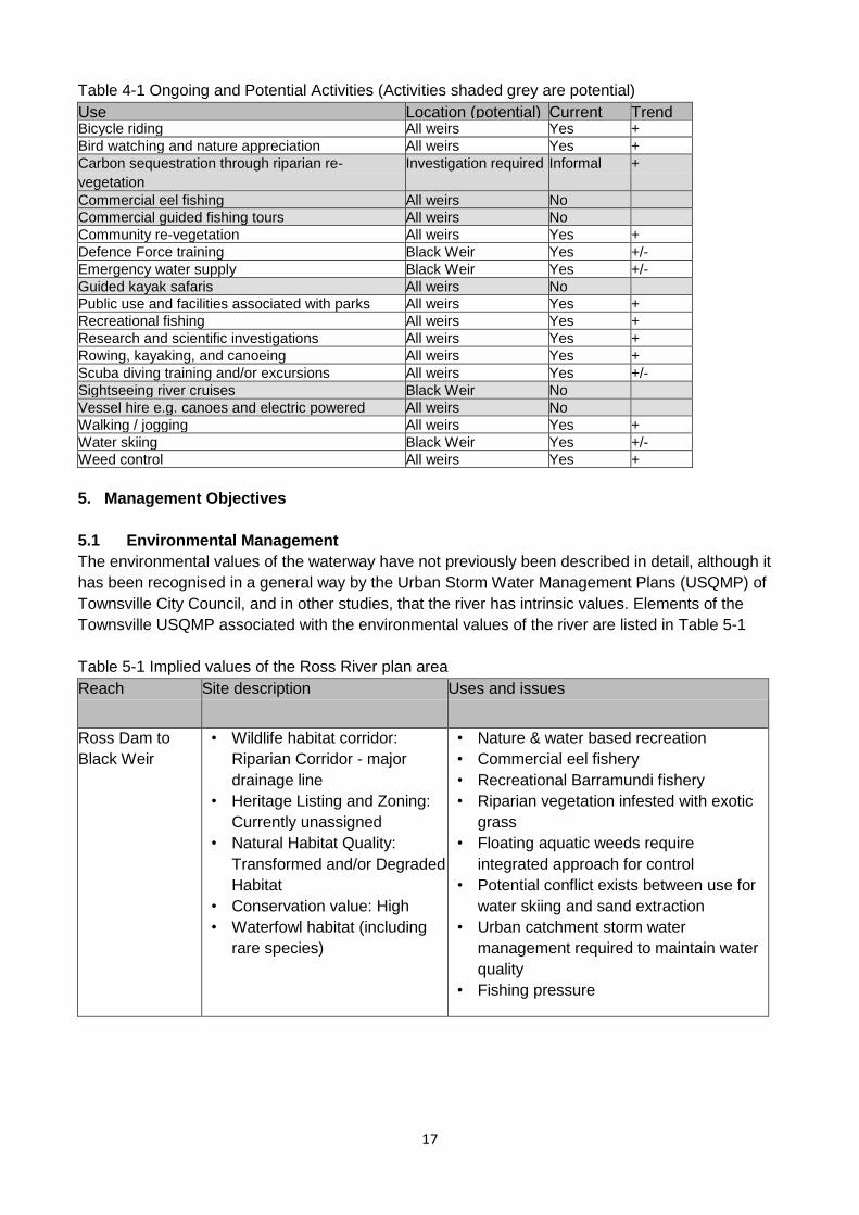
4.9 Ongoing and Future Activities
Table 4-1 lists ongoing and potential future uses associated with the Ross River waterway
identified during the preparation of the Management System. It includes an anticipated trend in
activity for each use based on consultation and anecdotal sources.
Only current activities have been addressed in the management planning with any future activities
subject to investigations by activity proponents and subsequent approval from the appropriate
authority. Future activities have been taken into account when developing management
arrangements and where necessary have been referred to in the context of approvals required and
management arrangements.
17
Table 4-1 Ongoing and Potential Activities (Activities shaded grey are potential)
Use Location (potential) Current Trend Bicycle riding All weirs Yes +
Bird watching and nature appreciation All weirs Yes +
Carbon sequestration through riparian re-
vegetation
Investigation required Informal +
Commercial eel fishing All weirs No
Commercial guided fishing tours All weirs No
Community re-vegetation All weirs Yes +
Defence Force training Black Weir Yes +/-
Emergency water supply Black Weir Yes +/-
Guided kayak safaris All weirs No
Public use and facilities associated with parks All weirs Yes +
Recreational fishing All weirs Yes +
Research and scientific investigations All weirs Yes +
Rowing, kayaking, and canoeing All weirs Yes +
Scuba diving training and/or excursions All weirs Yes +/-
Sightseeing river cruises Black Weir No
Vessel hire e.g. canoes and electric powered
tinnies
All weirs No
Walking / jogging All weirs Yes +
Water skiing Black Weir Yes +/-
Weed control All weirs Yes +
5. Management Objectives
5.1 Environmental Management
The environmental values of the waterway have not previously been described in detail, although it
has been recognised in a general way by the Urban Storm Water Management Plans (USQMP) of
Townsville City Council, and in other studies, that the river has intrinsic values. Elements of the
Townsville USQMP associated with the environmental values of the river are listed in Table 5-1
Table 5-1 Implied values of the Ross River plan area
Reach Site description Uses and issues
Ross Dam to
Black Weir
• Wildlife habitat corridor:
Riparian Corridor - major
drainage line
• Heritage Listing and Zoning:
Currently unassigned
• Natural Habitat Quality:
Transformed and/or Degraded
Habitat
• Conservation value: High
• Waterfowl habitat (including
rare species)
• Nature & water based recreation
• Commercial eel fishery
• Recreational Barramundi fishery
• Riparian vegetation infested with exotic
grass
• Floating aquatic weeds require
integrated approach for control
• Potential conflict exists between use for
water skiing and sand extraction
• Urban catchment storm water
management required to maintain water
quality
• Fishing pressure
18
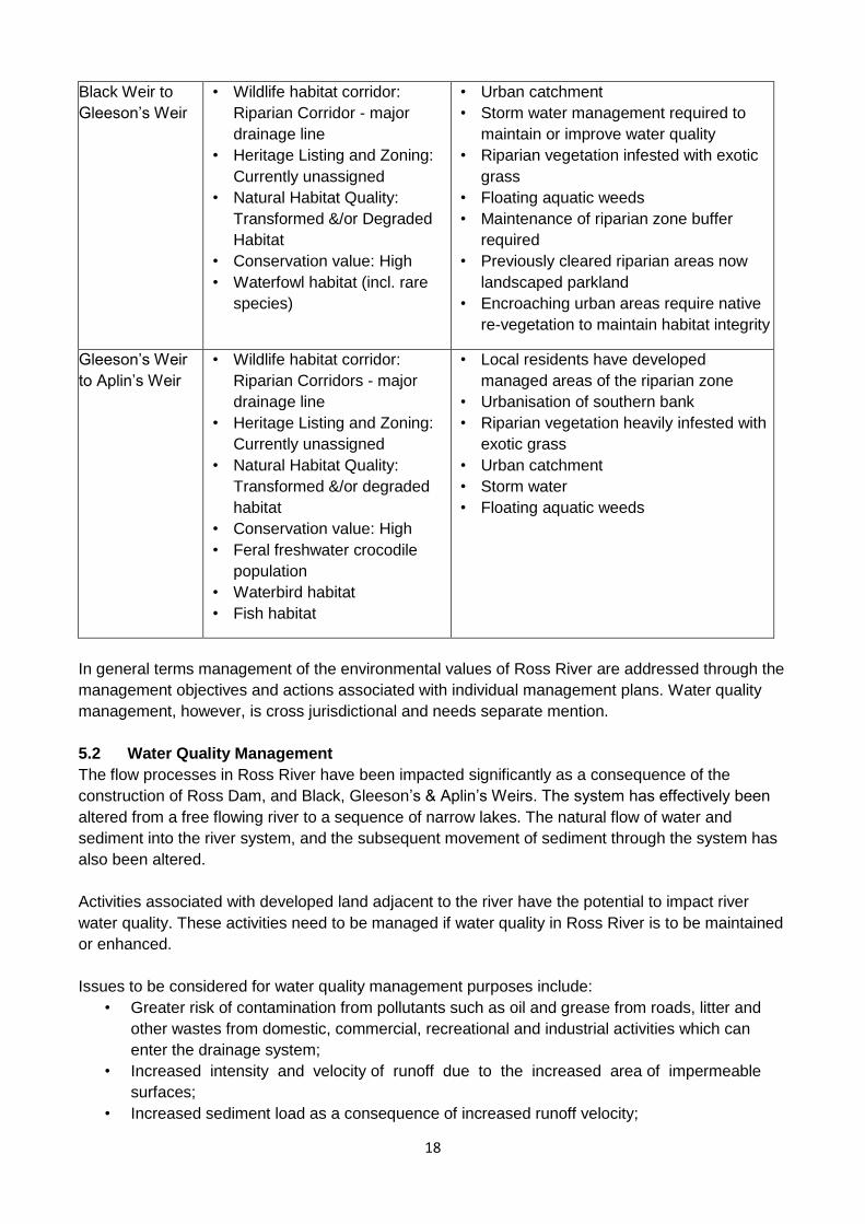
Black Weir to
Gleeson’s Weir
• Wildlife habitat corridor:
Riparian Corridor - major
drainage line
• Heritage Listing and Zoning:
Currently unassigned
• Natural Habitat Quality:
Transformed &/or Degraded
Habitat
• Conservation value: High
• Waterfowl habitat (incl. rare
species)
• Urban catchment
• Storm water management required to
maintain or improve water quality
• Riparian vegetation infested with exotic
grass
• Floating aquatic weeds
• Maintenance of riparian zone buffer
required
• Previously cleared riparian areas now
landscaped parkland
• Encroaching urban areas require native
re-vegetation to maintain habitat integrity
Gleeson’s Weir
to Aplin’s Weir
• Wildlife habitat corridor:
Riparian Corridors - major
drainage line
• Heritage Listing and Zoning:
Currently unassigned
• Natural Habitat Quality:
Transformed &/or degraded
habitat
• Conservation value: High
• Feral freshwater crocodile
population
• Waterbird habitat
• Fish habitat
• Local residents have developed
managed areas of the riparian zone
• Urbanisation of southern bank
• Riparian vegetation heavily infested with
exotic grass
• Urban catchment
• Storm water
• Floating aquatic weeds
In general terms management of the environmental values of Ross River are addressed through the
management objectives and actions associated with individual management plans. Water quality
management, however, is cross jurisdictional and needs separate mention.
5.2 Water Quality Management
The flow processes in Ross River have been impacted significantly as a consequence of the
construction of Ross Dam, and Black, Gleeson’s & Aplin’s Weirs. The system has effectively been
altered from a free flowing river to a sequence of narrow lakes. The natural flow of water and
sediment into the river system, and the subsequent movement of sediment through the system has
also been altered.
Activities associated with developed land adjacent to the river have the potential to impact river
water quality. These activities need to be managed if water quality in Ross River is to be maintained
or enhanced.
Issues to be considered for water quality management purposes include:
• Greater risk of contamination from pollutants such as oil and grease from roads, litter and
other wastes from domestic, commercial, recreational and industrial activities which can
enter the drainage system;
• Increased intensity and velocity of runoff due to the increased area of impermeable
surfaces;
• Increased sediment load as a consequence of increased runoff velocity;
19
• Issues with absorbing and buffering 'first flush' changes in water chemistry because of
increased intensity of runoff;
• Changes in the structure of riparian vegetation;
• Introduction of exotic flora and fauna; and
• Changes in the river system as a consequence of recreational activities (clearing of snags,
increased wave action from water sports, etc.).
The Environmental Protection (Water) Policy 2009 (EPP (Water), along with its head of power the
Environmental Protection Act 1994, is the most relevant legislative instrument outlining the
requirements for maintaining water quality, identifying environmental values and developing water
quality objectives.
The ANZECC Australian Water Quality Guidelines for Fresh and Marine Waters (AWQG) (2000)
and the Queensland Water Quality Guidelines 2009 (QWQG) establish default water quality
guidelines for setting water quality objectives (WQOs) for receiving waters with regard to the
beneficial human uses and ecosystem characteristics of water bodies. The WQOs are set for each
Environmental Value identified for each water body.
Environmental values (EVs) have been defined through the National Water Quality Management
Strategy (NSWQMS) and are also embedded in the EPP (Water), AWQG and the QWQG. The EVs
are; Ecosystem protection, Recreation (Primary, Secondary and Visual appreciation), Irrigation,
Stock watering, Farm use, Aquaculture, Human consumption, Drinking, Industrial and Cultural &
Spiritual.
During the preparation of the Black Ross (Townsville) Water Quality Improvement Plan (WQIP) EVs
were identified for waterways within the Townsville WQIP area i.e. Crystal Creek to Cape Cleveland.
The process for identifying the current condition of waterways and establishing draft EVs and draft
WQOs for specific waterways and waters, as per the NWQMS framework, is described in the
Townsville WQIP supporting document titled Environmental Values, Water Quality Objectives and
Targets for the Black Ross Water Quality Improvement Plan (Townsville Gunn, J., Manning, C. and
McHarg 2009). The process included identifying human use environmental values from background
studies, stakeholder consultation and three community workshops.
Given the different uses of the Ross River weir pools the EVs associated with each are slightly
different. It was assumed in the preliminary Ross River Waterway Management System that the
EVs for the water bodies behind Aplin’s and Gleeson's Weirs would be defined in terms of
ecosystem protection, recreation and aesthetics, while ‘raw water for drinking supply’ would be
added as an extra EV for Black Weir. This was confirmed as a function of determining the EVs for
the WQIP waterways. EVs for the Ross River (below the dam) are shown in Table 5.2.
When determining water quality management objectives the water type needs to be defined. The
Ross River between the Dam and Aplin’s Weir can be classed as a lowland river, wetlands or lakes.
The section below Aplin’s Weir is classed as estuarine. Guideline water quality values for lowland
rivers and estuaries from the Townsville WQIP (based on the Queensland Water Quality Guidelines
and NWQMS) are shown in Table 5-3.
The guidelines were used as the basis for determining the draft WQOs for Townsville WQIP waters
including Ross River and its weir pools. The WQOs for Ross River are shown in Table 5-4.
20
Table 5-2 Environmental Values
Waterway
Irrigation Farm
supply
Human
consumer
Primary
recreation
Secondary
recreation
Visual
appreciation
Drinking
water
Cultural /
spiritual
values
Aquatic
ecosystems
Freshwaters
Ross River (below
Dam) M L H H H H H
√
Ross River Weir
Pools (All) M H H H H H
√
Ross River (Black
Weir) H H H H H H H
√
Ross R (Gleeson’s
Weir) L H H H H H
√
Ross River (Aplin’s
Weir) L H H H H H
√
Tributaries (Defence
land) L L L L H
HEV (parts)
University (Campus)
Creek L L L M H
HEV (parts)
Lavarack Ck with
weirs L L L M H
√
Ross Creek and
tributaries H L L H H
√
Pallarenda H H H H √
Estuarine Waters
Waterway
Irrigation Farm
supply
Human
consumer
Primary
recreation
Secondary
recreation
Visual
appreciation
Industrial
use
Cultural /
spiritual
values
Aquatic
ecosystems
Ross River sub
basin H H H M H
√
Source: Table 2.3 and Table 2.5 in Environmental Values, Water Quality Objectives and Targets for the Black Ross Water Quality Improvement Plan (Gunn, Manning, and McHarg 2009)
21
Table 5-3 Water Quality Guidelines
Water type
Physio-chemical indicator and guideline value
Am
m N
Ox
id N
Org
N
To
tal N
FiltR
P
To
tal P
Ch
l-a
DO
(%
sat)
Tu
rb
Se
cc
hi
SS
pH
g/L g/L g/L g/L g/L g/L g/L
Lo
we
r
Up
pe
r
NTU m mg/L
Lo
we
r
Up
pe
r
Mid-estuarine 10 10 260 300 8 25 4.0 85 105 8 1.0 20 7.0 8.4
Lowland streams 20 60 420 500 20 50 5.0 85 110 50 n/a 10 6.5 8.0
Freshwater lakes/reservoirs 10 10 330 350 5 10 5.0 90 110 1-20 nd nd 6.5 8.0
Source: Table 3.2 (Gunn, Manning, and McHarg 2009).
Notes: These are the Water Quality Guidelines for the Central Coast Queensland region (Burnett River Basin to Black River Basin) for slightly-moderately disturbed aquatic ecosystems. Mid-estuarine water
type includes tidal canals, constructed estuaries, marinas and boat harbours.
n/a is not applicable and nd is no data.
Amm N = ammonia nitrogen, Oxid N = oxidised nitrogen, Org N = organic nitrogen, Total N = total nitrogen, FiltR P = filterable reactive phosphorus, Total P = total phosphorus, Chl a = chlorophyll a, DO =
dissolved oxygen (percent saturation), Turb = turbidity, Secchi = Secchi depth.

22
Table 5-4 Water Quality Objectives
Indicator Freshwater Estuarine
Upland Lowland Lakes Mid estuary Upper estuary
TSS (mg/L) - 10 10 20 25
Ammonia N (g/L) 10 20 10 10 30
Oxid – N (g/L) 15 60 10 10 15
DIN – N (g/L) 25 80 20 20 45
Organic N (g/L) 225 420 330 260 400
Total N (g/L) 250 500 350 300 450
FRP – P (g/L) 15 20 5 8 10
Total P (g/L) 30 50 10 25 40
Turbidity (NTU) 25 50 1-20 8 25
Chlorophyll a (g/L) na 5 5 4 10
Dissolved Oxygen (%) 90-110 85-110 90-110 85 70-105
pH 6.5-7.5 6.5-8.0 6.5 7.0 7.0-8.4
EC* (µS/cm) 375 375 375
Source: Table 3.2 (Gunn, Manning, and McHarg 2009).
Notes: Values are for Slightly to Moderately Disturbed (SMD) waterways using QWQG figures for Central Coast (CC) (on the left) and Wet Tropics (WT) (on the right) i.e. CC/WT, unless figures are the same
for both regions.
nd is no data available. Where there is no data available the Central Coast values are adopted for the whole of the Black Ross (Townsville) WQIP area.
Dissolved oxygen is % saturation. DIN is the sum of Ammonia N and Oxid – N (oxidised nitrogen i.e. NOx).
* Conductivity values (EC) for freshwaters (from the QWQG Appendix G, p.103) for Central Coast North, based on the 75th percentile value, is 375 µS/cm for the Black Basin. The Ross Basin is in the
Burdekin-Bowen region and the corresponding value is 271 µS/cm.
Water Quality Guideline values – Human use exception to the aquatic ecosystem WGQ values:
Turbidity - Drinking water (aesthetics) guidelines for turbidity are more stringent for freshwater i.e. 5 NTU (Nephelometric turbidity unit).
23
5.3 Recreational Use Management
All of the weirs in the area of the plan have recreational use value for the community. While Aplin’s
and Gleeson’s Weirs are small in size (length) and relatively shallow they and their surrounding
riverbank parklands are important to the local residents and there are sport and recreation activities
that make use of the waterway. Due to the proximity of residential development, and the minimal
capacity of the weirs, the nature of this use should be unpowered and limited in volume.
Black Weir is much longer, wider, and deeper and has less development in close proximity. As a
result its recreational use potential is greater. The Black Weir is able to deal with multiple uses at
the same time, to service many different types of use, and to enable the staging of organised
activities and events. Due to its size it is able to accommodate a competition sized rowing course
as well as a waterskiing training and competition course, and still have room for public recreational
use for both powered and unpowered watercraft. The management of this recreational use has
required the creations of “use zones”, a permitting system, the identification of certain times when
certain types of use are restricted, and the development of a boat ramp to provide access. To be
effective, the management of recreational use requires collaboration among all user groups, and to
ensure safety requires the respect of regulations and other users by all who use the weir.
6. Use Management Planning Consultation
6.1 Introduction
Consultation for the revised use management arrangements consisted of several meetings to
ensure that all points of contention were understood and addressed. The main issues discussed are
described in this section.
6.2 Black Weir
Black Weir was the subject of most of the discussion due to the issues associated with recreational
activities and the impacts of development in and adjacent to the weir pool.
Initial Meeting
The meeting was facilitated by Townsville City Council. Main discussion points included:
Use and Management Objectives
The general objective is to keep the river accessible to as many uses and users as possible. This
includes continuation of current uses such as rowing and water skiing, while still enabling use by the
public.
Riverway
The boat ramp at Pioneer Park is now closed and there will not be a ramp accessible by the public
in the area. The old ramp still exists and is able to be accessed by user groups to support/enable
event staging.
Douglas Arterial Road
The main issues associated with the bridge relate to safety and the use of motorised vessels in the
vicinity of the bridge. There is a 6 knot speed limit in the vicinity of the bridge.
Boat Access
Boat access to Black Weir is via the boat ramp at Loam Island. During an aquatic event that
requires the closure of the boat ramp gate to ensure safety of all users an Event Permit from
24
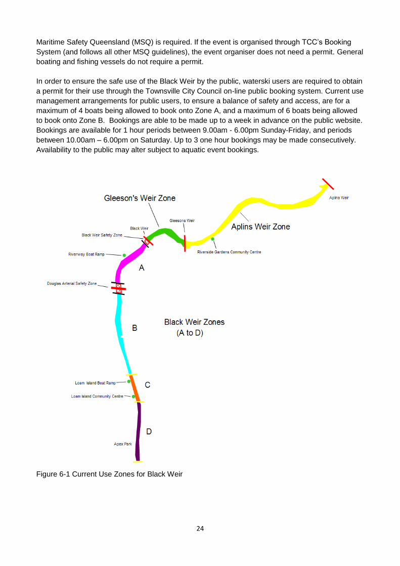
Maritime Safety Queensland (MSQ) is required. If the event is organised through TCC’s Booking
System (and follows all other MSQ guidelines), the event organiser does not need a permit. General
boating and fishing vessels do not require a permit.
In order to ensure the safe use of the Black Weir by the public, waterski users are required to obtain
a permit for their use through the Townsville City Council on-line public booking system. Current use
management arrangements for public users, to ensure a balance of safety and access, are for a
maximum of 4 boats being allowed to book onto Zone A, and a maximum of 6 boats being allowed
to book onto Zone B. Bookings are able to be made up to a week in advance on the public website.
Bookings are available for 1 hour periods between 9.00am - 6.00pm Sunday-Friday, and periods
between 10.00am – 6.00pm on Saturday. Up to 3 one hour bookings may be made consecutively.
Availability to the public may alter subject to aquatic event bookings.
Figure 6-1 Current Use Zones for Black Weir
25
Current Situation
The previous plan (2013) was generally suitable, but able to be improved to better accommodate
the number of users and gradual increases in demand. The main issue is that the rowing course
overlaps with two use zones, including Zone C which includes water access. Any use management
arrangements that are developed need to accommodate both organised sport/recreation use while
allowing continued use by the general public.
The current plan (2015) is again generally suitable to manage use for both organised activities and
public use. With no changes to Zones within Black Weir, the main issue is providing fair access to
all user groups and the public, noting that primary water access is at the Loam Island boat ramp
(Zone C). Figure 6-1 (above) shows the current use zones for Black Weir.
Other Vessels and Fishing
Unpowered boats and canoes in the upstream areas are consistent with waterway use in those
areas i.e. quieter areas and residential stretches. Fishing from banks is another use, and as with
fishing from boats is probably under utilised. Fishing from banks is dependent on weed density.
When there is a flow in the stream lots of fishers use the weirs.
Residential Development
Among the concerns that Townsville City Council has with regard to recreational use relates to
potential noise complaints in the vicinity of Riverside Gardens and the Itara residential complex at
Riverway. There is no intent to recommend limiting use or imposition of new regulations. Time
based current use patterns for powered vessels should be adequate with the EPA Noise Policy
sufficient for any dealing with potential complaints. Measured against background noise it is unlikely
there will be a problem with 'nuisance' noise from these vessels.
Speed limits
A 6 knot speed limit is currently in place for Zone C. The reason for this was to restrict powerboat
use for safety reasons. Rowing craft and motorised vessels operating as support vessels to rowing
craft underway are exempt from this limitation. The speed limit in Zone C is also in keeping with
maintenance of the Loam Island area as an environmental reserve. The zone is not seen as
compatible with activities such as waterskiing which require a designated area for its organised
activities. However events may be staged in Zone C that exceed this speed limit with an MSQ Event
Permit, which requires Townsville City Council concurrence.
Access and Viewing Opportunities
The main issue for skiers with the Loam Island ramp is the distance to use zones and the lack of
vantage points for spectators. It is a social activity and locations are needed for spectators. With
rowing, the main action for spectators is at the finish line. Competitors are able to use a transit lane
to move from the launching area to the start line and from the finish line to the launching area.
Water Course Markers
The rowing course does not have permanent in-water markers for events as the cost is prohibitive.
Markers on the riverbank suffice for distance measurement including marking start and finish lines.
The setup of rowing course markers on a seasonal basis was not allowed within the current rowing
course based on a risk assessment of the activity and site. Council have no objection however to
course markers being installed on a seasonal basis and maintained by the club, should future
applications be received and course markers met risk assessment guidelines at the site.
Waterskiing also requires a marked course which is difficult to remove and install. Any new zone
designated as an area for its organised activities should include semi-permanent course marking
26
buoys. The installation of waterski course markers was approved based on a risk assessment of the
activity and site. Townsville City Council has no objections to waterskiing course markers being
installed on a seasonal basis and maintained by the waterski club.
Swimming
Swimming in Black Weir is common but usually numbers are small. Weeds tend to discourage
access from many parts of the river. The most frequented areas include water within Zone D
(access from Apex Park) and also water within Zone A (access from the banks alongside Riverway).
Ropes on trees beside the river are a safety issue especially in relation to unseen snags and other
objects. Generally swimming in the river is not encouraged. Any events that involve swimming that
are held will need to show that they are adequately covered by insurance and that Council will not
be held responsible for any incidents that occur.
Commercial Use
Recreational sight-seeing and fishing tours are a potential commercial use and Townsville City
Council has been approached in the past about the matter. Spatial separation arrangements would
need to be investigated with the general area upstream of Loam Island considered to be the most
suitable, with Loam Island to be used as the staging point. The concept of a canoe/kayak hire
enterprise is supported by Townsville City Council.
Coordination of Recreational Use
Activity coordination is currently the role of Townsville City Council with an informal Ross River
Waterway Management Group existing consisting of user groups and Council with advice from
relevant agencies.
Education and Awareness
Education on speeds as well as boating and waterway use safety will be required regardless of the
recreational use management arrangements decided upon.
Aquatic Weed Management
The management of aquatic weeds has a major impact on the use within Black Weir. The level of
control of aquatic weeds may not be the same as that desired by users, and throughout any
particularly year there may be effects on usage because of aquatic weed. Preventative maintenance
should continue to ensure aquatic weeds do not get out of control. See section 6.5 for more detail.
Other Environmental Considerations
Other considerations include:
• As a result of control measures, erosion in the Pioneer Park area is not considered a major
problem;
• Riparian zone management is needed, especially weeds such as Singapore Daisy and
Chinee Apple;
• Monitoring program required to note any changes in condition and water quality;
• Collation of studies e.g. for Riverway, any by JCU, CSR Flora and Fauna study; and
• The access road to Allambie Lane sand extraction area to be rehabilitated after use.
Specific Issues
Dept. of Defence is interested in the potential impacts of increased recreational activity and the
likelihood of incursions on Defence land from recreational river users. Defence will monitor activities
and see if any more action is required to secure their land. Additional signage and education may

27
be required. The main issue may come from the Townsville City Council side of the river as new
residents look for walking and riding tracks. Defence training activities associated with the river may
also increase and that needs to be noted and accommodated.
Follow Up
A meeting with the Riverway Rowing Club and Townsville Water Ski Club (in 2013) was held as a
follow up to the initial meeting.
In the 2015 review, discussions with Riverway Rowing Club and Townsville Water Ski Club
indicated that while there are primary seasons for Rowing and Skiing, events and training are held
throughout the whole year.
Information from these meetings included:
Rowing is predominantly a winter sport, as the endurance nature of the activity is not compatible
with the tropical summer. Training during the summer takes place early in the morning before the
heat becomes too intense, or later in the afternoon/evening. It is desirable to use the full course for
training and events, which is two kilometres long.
Water skiing is more pronounced in summer with major competition events usually scheduled for
that time. The sport has a major social/family component and is a spectator sport as a boat tows
only one skier at a time. Participants waiting their turn generally wait at a staging area/s on the
riverbanks. Boat launching access means all powerboats are required to launch from Loam Island.
This will require low speed (6 knot current limit) traverse to the waterskiing zones with gear and
equipment as required, unless there is some other form of access to the river closer to the
waterskiing areas where vehicles can be parked and spectators and equipment unloaded.
Water Ski Club members are considered to be more responsible and knowledgeable about safety
and social issues than the general boating public due to the rules and regulations, which are a
condition of membership. Unsafe or inappropriate activities by the general public are often the
cause of conflict and when people ignore booking arrangements or contravene safety regulations
Townsville City Council Regulatory Officers can be contacted to deal with the situation.
As the current permit system is session based, boat launching and removal tends to be compressed
into the very start and end of the time periods. This means that there will be a number of boats and
trailers trying to manoeuvre in the vicinity of the boat ramp at Loam Island at the same time.
Timing of major events requires a long lead-time to allow for advertising and notification. Water Ski
events affect rowing activities because of travel from the boat ramp to the event areas. Rowing
events impact skiing as the rowing course runs through Zone C (and shared boat ramp). Therefore
on days when rowing regattas or major waterski events are held, several use zones may not be
available for use.
During rowing club activities (where either Zones B and C or Zones A, B and C are booked) a transit
lane adjacent to the northern bank is utilised by rowing vessels. During regattas, access to Zone A
(public use) and Zone D (Ski Club member use) will be restricted. Events restricting access to the
river will be limited in number and confirmed by Council in the event booking period in preparation
for the following year. During regular rowing training (where Zones B and C are booked) public ski
boats (travelling to Zone A) and Ski Club members (travelling to Zone D) are required to use this
transit lane and travel at a safe speed until in there booked zone.
28
Bookings both for regular use and events need to be planned carefully and well in advance.
Communication between Council, relevant user groups and the public needs to be consistent and
be planned to provide sufficient notice periods for all parties.
6.3 Aplin’s and Gleeson's Weirs
General
The areas (Figure 6-2) are the responsibility of Townsville City Council. Both of these weir pools
also require use management arrangements to be formalised.
Use Considerations
The considerations regarding use include;
a) The main access point for boats to Gleeson’s Weir is via the park below the Black Weir.
b) The Ross River Parkway is progressing according to plan with the substantial body of work
now being carried out below Aplin’s Weir to the Bowen Road Bridge. Bikeways and walking
trails are being constructed at present. Little additional work has been done on park nodes.
Community groups are also involved in re-vegetation of riparian area assisted by
Environmental Management Services Natural Areas Team. There is a need for additional
access points for fishing and launching of canoes, and this must be assessed and
incorporated in future works planning.
c) The fishing potential of the weir pools is probably under utilised given the number of fish
present and the ongoing stocking program. There is good potential to expand recreational
fishing. While the presence of aquatic plants impacts the fishing experience from the banks,
good fishermen seem to be able to adapt and alter their methods and equipment to suit. The
main issue is gaining access to the river to enjoy the fishing experience eg. access for
canoes.
d) Rowing club activities are centered around the boatshed in Aplin’s Weir at Riverside
Gardens. There is a need for another boat storage area and Cathedral School has
expressed an interest in establishing a facility in the region near Aplin’s Weir. The behavior
of club members is managed by the club Codes of Conduct.
e) Wherever possible, natural areas should be retained along the river rather than establishing
more formal parks or re-engineering the banks. The main issue is access for fishing and
launching of canoes. At present some people living near the river have their own hand
trailers, which they use to get their vessels to the water. Apart from that there are limited
access points for people wishing to be use the waterway i.e. parking and carrying a boat to
the water is required.
Speed Limits
Motorised vessels (unless those supporting rowing craft with club training or event bookings) are not
permitted within Aplin’s Weir. The current gazetted 6 knot speed limit will remain unchanged even
though rowing vessels and their support boats may exceed the limit. The speed limits within the weir
pools are not intended to restrict use by rowing vessels or their support craft.
Rowing
Rowing is an established and encouraged use of the weir pools. The pontoon at Riverside Gardens
is the property of the Townsville /James Cook University Rowing Club (TJCURC).
A second access point and boatshed may be required in the future as the limiting factor for the sport
is the ability to get the rowing gear to the water. The development, and coordination of the
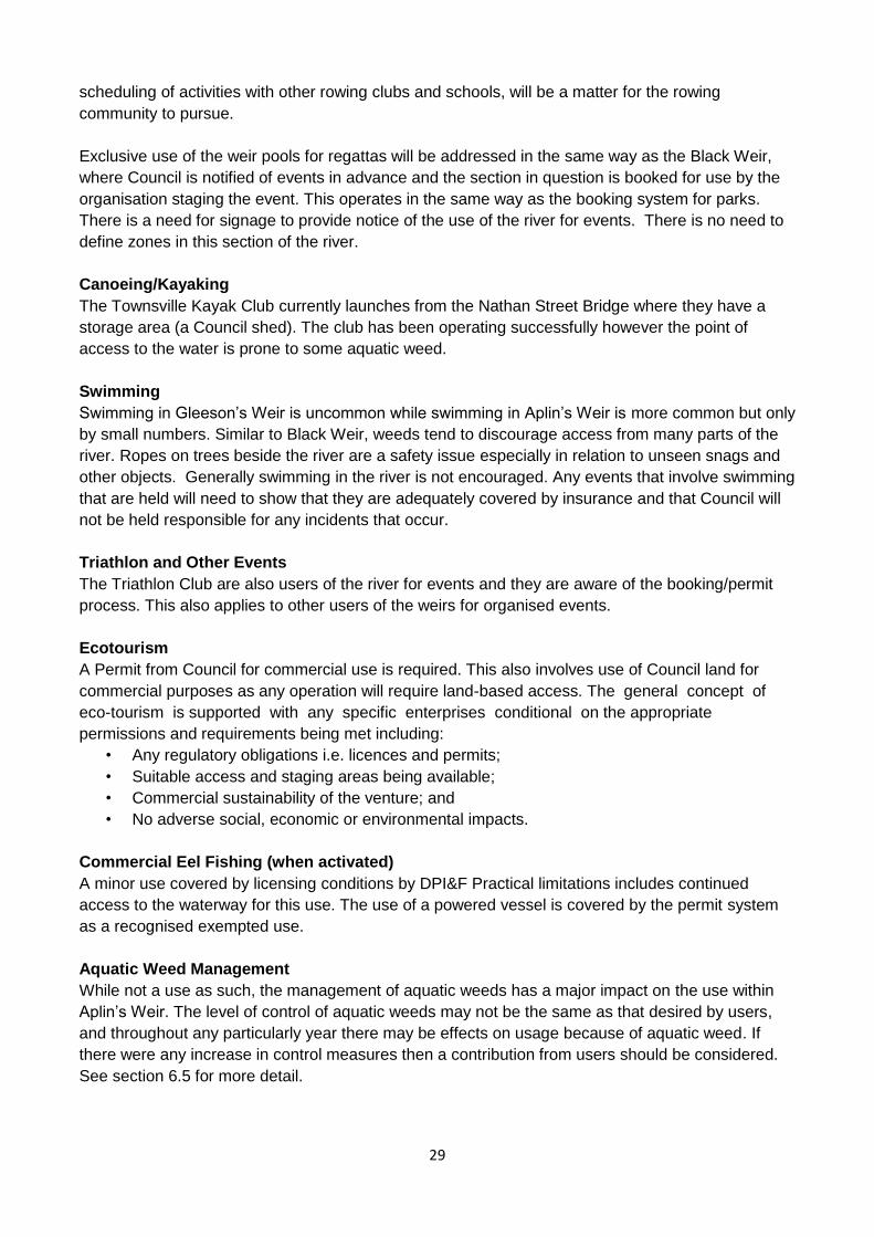
29
scheduling of activities with other rowing clubs and schools, will be a matter for the rowing
community to pursue.
Exclusive use of the weir pools for regattas will be addressed in the same way as the Black Weir,
where Council is notified of events in advance and the section in question is booked for use by the
organisation staging the event. This operates in the same way as the booking system for parks.
There is a need for signage to provide notice of the use of the river for events. There is no need to
define zones in this section of the river.
Canoeing/Kayaking
The Townsville Kayak Club currently launches from the Nathan Street Bridge where they have a
storage area (a Council shed). The club has been operating successfully however the point of
access to the water is prone to some aquatic weed.
Swimming
Swimming in Gleeson’s Weir is uncommon while swimming in Aplin’s Weir is more common but only
by small numbers. Similar to Black Weir, weeds tend to discourage access from many parts of the
river. Ropes on trees beside the river are a safety issue especially in relation to unseen snags and
other objects. Generally swimming in the river is not encouraged. Any events that involve swimming
that are held will need to show that they are adequately covered by insurance and that Council will
not be held responsible for any incidents that occur.
Triathlon and Other Events
The Triathlon Club are also users of the river for events and they are aware of the booking/permit
process. This also applies to other users of the weirs for organised events.
Ecotourism
A Permit from Council for commercial use is required. This also involves use of Council land for
commercial purposes as any operation will require land-based access. The general concept of
eco-tourism is supported with any specific enterprises conditional on the appropriate
permissions and requirements being met including:
• Any regulatory obligations i.e. licences and permits;
• Suitable access and staging areas being available;
• Commercial sustainability of the venture; and
• No adverse social, economic or environmental impacts.
Commercial Eel Fishing (when activated)
A minor use covered by licensing conditions by DPI&F Practical limitations includes continued
access to the waterway for this use. The use of a powered vessel is covered by the permit system
as a recognised exempted use.
Aquatic Weed Management
While not a use as such, the management of aquatic weeds has a major impact on the use within
Aplin’s Weir. The level of control of aquatic weeds may not be the same as that desired by users,
and throughout any particularly year there may be effects on usage because of aquatic weed. If
there were any increase in control measures then a contribution from users should be considered.
See section 6.5 for more detail.
30
Figure 6-2 Aplin’s and Gleeson's Weir Pools
Aplin’s and Gleeson Weirs Responsibilities
The current arrangements for the use of land based parks and reserves are described in Townsville
City Council Local Laws. Council provides base level maintenance and any additional requirements
above and beyond that level are the responsibility of the sporting clubs. This includes provision of
amenities required for the particular activities e.g. goal posts. The intentions, if not provisions, of the
Local Law may be applied to the weir pools behind Aplin’s and Gleeson's Weirs.
The process used by Council to enable use of parks for events is a simple booking system
administered by the Community Services Department. The applicant makes contact and advises of
their request for use. The request is checked against the diary to ensure there are no previous
bookings for the requested area. If there are no unresolvable issues and the request is approved a
booking agreement is sent to the applicant with conditions of use. The same booking system is
used for Aplin’s and Gleeson's Weirs.
- Aplins’s - Gleeson’s - Black
31
Operation of the booking system is straightforward however the derivation of the authority to grant
and enforce exclusive use of the water bodies, or part thereof, is not as clear. While Aplin’s and
Gleeson's Weirs are the responsibility of Townsville City Council, and therefore management of the
impounded water is by default the responsibility of Council, the 'ownership' of the water body is less
apparent.
The land below the water body i.e. beds and banks, is State land as defined under the Water Act
2000. Approval is required from the DNR&M to disturb the bed or banks or to extract water from the
river system.
Implementation of use management may require the drafting of new Local Law to deal specifically
with the weir pools as they cannot be designated as 'Park' or 'Reserve' as there is no land to be
assigned.
Regardless of the process used to manage the use of the weir pools, the public will need to be
made aware of the arrangements, including permitted and restricted uses.
6.4 Riparian Zones
Specific Riparian Zone Issues
There is ongoing management of the riparian zone between Aplin’s Weir and the Ross Dam.
Management arrangements recognize the relatively homogeneous sections of the river. The main
points are summarised below.
Allambie Lane to Ross Dam
Allambie Lane marks the point where houses have river frontage. Downstream of Allambie Lane,
Riverway Drive runs parallel to the river.
A weed management strategy for the river banks exists. The re-vegetation strategy also identifies
the river as an important area for re-vegetation although there are no major plans for re-vegetation
works.
Pest management is concentrated primarily on Declared Plants and work is done along the river
when possible. There is monitoring for Siam Weed and other potential pest invasions, as part of
normal activities. Weed locations are recorded and translated onto maps as required.
Corveth's Waterhole is an area of focus for weed control in conjunction with community volunteers.
There is significant weed infestation on Dept. of Defence land in the area. The Commonwealth is a
major landowner fronting the river and needs to be included in a coordinated weed management
program for the riparian areas in the relatively natural stretch below Ross Dam.
As the responsibility for maintenance of the river is a 'grey area' the most equitable solution would
be for all relevant agencies and adjacent landowners to be involved in its maintenance, including
riparian weed control measures. A condition assessment of the area has not been carried out and
would be a practical first step in the management process, along with the formation of a riparian
management-working group to include City Council, Dept. of Defence, Landcare, and DNR&M,.
32
Pioneer Park to Allambie Lane frontage
The Riverway nodes at Pioneer Park and Loam Island are the focus of attention for this stretch of
the river. A track from Apex Park to Loam Island exists and is maintained by Townsville City
Council, as are the formal park areas.
Weed control from Pioneer Park to Loam Island is relatively easy due to steep banks (lower
incidence of light) and less weed presence. A walking track closer to the river is 'planned' for the
future. This will be separate to the current high bank bikeway. The entire section from Pioneer Park
to Allambie Lane is considered by Council to be adequately managed given the current
development in the area and accessibility.
The main management issues are in the vicinity of Kingfisher Lagoon with the area near the mouth
of the lagoon requiring cleaning out due to the amount of sediment, whci h is impeding hydrological
functioning of the lagoon.
The flatter areas in the vicinity of the lagoon are host to a variety of weeds including Chinee Apple,
Rubber Vine and Para Grass (in the wetter sections). A Management Plan will be developed for the
area around Kingfisher Lagoon in conjunction with Townsville City Council. Whilst fire may be a
useful management tool in the management plan, a number of issues associated with its use in
developed areas must be resolved before implementation. Previous experience in other parts of the
City has shown that fire is one of the more effective methods for controlling Para Grass.
Upstream from Kingfisher Lagoon the riverbanks are steeper and there are no plans to do any
formal park works in that area. A bridge across the lagoon mouth is part of a pathway circuit around
both sides of the wier involving the Douglas Arterial Bridge and the Black Weir Bridge.
Riparian areas in the Riverside Gardens development are under the management of Townsville City
Council and are generally maintained.
Riverside Gardens to Aplin’s Weir frontage
This stretch consists mostly of formal parks with a narrow band of remnant riparian zone vegetation.
As with the previous section, it is maintained by Townsville City Council (Figure 6-4).
A section of the riparian zone downstream of Black Weir (Riverbend Sanctuary) is maintained by the
Dry Tropics Biodiversity Group, a community group. The area requires minimal work.
An issue associated with Gleeson's Weir is the occurance of fish kills associated with reduced
oxygen concentrations as water temperatures rise, water levels reduce and organic matter decays
in a relatively small body of water.
Endeavour Creek is probably the main area requiring attention if areas are being identified for
additional action. Additionally, development in the university grounds has caused creek impacts in
the section where the main Riverside Road approaches the Douglas Arterial Road.
Aplin’s Weir to Bamford Lane frontage
This section of the river includes the majority of community re-vegetation sites and 'natural' areas
including; the Bush Garden and the island near Aplin’s Weir. There is a mix of formal parks,
bikeways and walking tracks and semi natural river banks with various degrees of accessibility.
33
Aplin’s Weir Park to Rossiter Park is dominated by relatively low banks and semi-formal parkland.
The banks become more pronounced from Nathan Street with the banks from Nathan Street to
Alice Street drain having largely been re-vegetated with regular weed control carried out.
Community re-vegetation has also been undertaken in the section 100m upstream of Alice Street
drain (Karang Court) where the banks are generally steeper. Better access for recreational fishing
could be investigated. Weed control is carried out in these sections. Re-vegetation is planned in the
section from Alice Street to Gleeson's Weir and currently some weed control is carried out in that
section. There is a concentration of Guinea Grass in the area before Gleeson's Weir, which is
difficult to maintain due to steepness of banks and accessibility for staff and equipment. Singapore
Daisy is also an issue and may be spread by mowing.
General Matters
Pest Management
The Townsville City Council Pest Management Plan is species focused and does not usually
address issues associated with the river unless it is a matter relating to declared plants such as
Parkinsonia and Leuceana. The pest management team is currently looking at having some plants
declared as local weeds.
Community Groups
Issues raised concerning community involvement in re-vegetation related to the legal and insurance
implications i.e. workplace health and safety issues. Council activities are covered through
inductions and sign-ons while Landcare general insurance cover should be adequate for other
purposes, as long as all the requirements are met. Individuals involved in non-organised activities
are liable for their own actions are not covered by insurance.
The other issue area was associated with training for volunteers. This was not discussed in length
as it was considered to be more of an organisational and partnership issue to be dealt with on a
project by project basis rather than as a Ross River riparian management zone specific issue.
Native Grasslands
While re-vegetation tends to focus on trees and shrubs the retention of native grasslands is
important for birds.
6.5 Aquatic Weed Management
The issue of aquatic weed management was raised during consultation as an issue affecting the
river and recreation or as a matter to consider when planning riparian management and
development. The main points associated with aquatic weed management not mentioned in
previous sections appear below.
Weed Harvester Access
Preventative management is used primarily for floating aquatic plants with the weed harvester
required to control submerged aquatic plants. If weed harvesting were to be carried out it would be
instigated around May if 'natural' flushing of the river is not adequate to remove the mass of aquatic
plants from the system in the preceding summer (wet season). Water access for the weed harvester
is one consideration, however the main issue is the removal of the aquatic weed from the river and
the distance travelled by the harvester, or a support vessel, to areas where weed can be off loaded.
At present the access and off loading points are:
• Loam Island (Black Weir access)- Priority,
34
• Arinya St (Black and Gleeson's Weir access and offloading) -Priority ;
• The park below Black Weir (off loading)- Priority,
• Victor Street (Aplin’s Weir access); and
• Nathan Street bridge (off loading) - Priority.
Access and off-loading areas will be maintained in Council's park planning and development. In the
case of the park below Black Weir, in the event that a retaining wall is built to bolster up the bank,
then a cutting/ramp will have to be installed to enable continued access.
Weed Handling and Disposal
Roping off areas to capture floating weed may be useful to retain weed in areas for harvesting
purposes. Generally weed material dragged onto shore is not easy to handle for application to parks
nearby, and the best option is to remove it from the site altogether. However, Council has found it is
able to deal with and use it on site in the Gleeson Weir Park (downstream of Black Weir). The
difference may be due to the time allowed for the material to dry in situ i.e. stockpile the material
prior to use.
Aquatic Weed Control Costs
Preventative maintenance is currently undertaken by Townsville Water on behalf of TCC
Maintenance Services at an approximate cost of $1,000 a day (two people, equipment and
chemical). The operation is carried out on an as needed basis.
Preventative maintenance consists of spraying surface weeds near the banks from a boat to
prevent the further expansion into the waterway. The frequency of spraying has to be balanced
against the environmental impacts. Infrequent control can result in a substantial build-up with
spraying creating impacts from the breakdown of dead plant material and de-oxygenation of the
waterway. Greater volumes of herbicide are required for larger infestations.
Development of Key Performance Indicators (Trigger Criteria) to determine when to spray is
required. At present the team has a 'rule of thumb' that says when weed has spread 3-4 metres
from the banks it is time to spray.
The planning and budgeting associated with carrying out aquatic weed removal by the weed
harvester should be thorough and organised by the necessary department stakeholders. Costs of
work could range between $30,000 and $100,000 depending on the amount of river treated.
7. Management Plans and Actions
7.1 General Comments
Even though the management plans proposed have been divided into management components,
there is considerable overlap between the contained management elements that require a
coordinated approach. The first management category (Governance, Communication and
Awareness) is crucial to the effective operation of the Ross River Waterway Management System
(RRWMS) as it underpins all the following management actions.
7.2 Governance, Communication and Awareness
Management Objectives
The main objective is:
35
To facilitate a coordinated and integrated approach to the management of the Ross River Waterway
between Aplin’s Weir and Ross Dam to ensure the environmental, cultural, and recreational values
of the river and its tributaries are maintained for the benefit of all.
7.3 Condition Assessment
Management Objectives
The main objective is:
To determine the physical condition of the plan area to:
• Provide a baseline for monitoring and evaluation;
• Assist with future planning for provision of recreational facilities;
• Identify areas requiring re-vegetation and restoration works;
• Provide background information for funding applications; and
• Assist with coordinated pest management activities.
7.4 Cultural Heritage
Management Objectives
The main objective is:
To determine the capacity and desire of Traditional Owners and Traditional Owner groups to be
involved in the assessment of cultural heritage values of the Ross River study area and to be
involved in ongoing cultural and natural resource management of the waterway and adjacent
riparian areas.
7.5 Management Objectives
General
Section 5 provides general information on environmental values of the Ross River waterway and
water quality management objectives. The Creek to Coral initiative is an appropriate forum to
progress water quality management for the Ross River, and for other waterways in the Townsville
coastal plain. As part of the process the following elements should be considered;
• Review of existing water quality monitoring data to identify gaps in datasets and the most
appropriate means to address shortfalls;
• Coordination and data sharing between the various water quality monitoring programs
undertaken in the catchment;
• Regular review and evolution of management and monitoring programs to best meet
evolving environment, community and stakeholder needs;
• Identification of key point source inputs contributing to reductions in water quality and
development of strategies to improve those inputs;
• Increased stakeholder awareness of the relationships between their activities and water
quality (both positive and negative), and the actions they can take to maintain I improve
water quality (eg adjacent landholders, recreational boaters, fishermen, etc);
• Improved information dissemination between key stakeholders, the public and monitoring
groups to ensure effective coordination and integration of the various water quality
management activities being undertaken, and make best use of available resources;
• Integration with riparian vegetation and aquatic ecosystem management activities;
• Integration with those pest management and eradication activities that are fundamentally
linked with water quality;
• Setting of long-term acceptable water quality benchmarks; and
• User and stakeholder 'ownership' and responsibility for the riverine system.
36
7.6 Riparian Management
Management Objectives
The main objective is:
To encourage coordinated management of the riparian zone in order to maintain and enhance
environmental values, and provide opportunities for community involvement in management of
'natural' areas.
7.7 Aquatic Weed Management
Management Objectives
The main objective is:
To ensure aquatic plants are managed to maintain the ecological and water quality values of the
Ross River weir pools.
7.8 Stormwater Management
Management Objectives
The main objective is:
To encourage a coordinated approach to management of stormwater quality for the Ross River
below Ross Dam.
7.9 Aplin’s and Gleeson's Weirs
Management Objectives
The main objective is:
To formalise Townsville City Council’s management of the use of Aplin’s and Gleeson's Weirs
Additional management objectives may also be contained or implied in the management objectives
and actions associated with other components of the Ross River Waterway Management System.
7.10 Black Weir
Management Objectives
The main objectives are:
• To protect and improve the water quality of the weir pool contained by Black Weir;
• To ensure coordinated management of the waterway in accordance with legislative
requirements and community desires;
• To provide for appropriate access for recreational use of the weir pool
• To regulate activities and conduct to manage erosion; and
• To protect the safety of persons using the weir pool by ensuring appropriate standards of
conduct are maintained.
Additional management objectives may also be contained or implied in the management objectives
and actions associated with other components of the Ross River Waterway Management System.
Considerations
The Riverway project has effectively transformed Loam Island to be the centre of water based
recreation and sports with the construction of a multi-use community facility to house the Scouts and
Guides, the Riverway Rowing Club and the Townsville Water Ski Club. The only public access boat
ramp on Black Weir is located within the two kilometre rowing course.
Management to the recreational use zone of Black Weir revolves around:
• A booking system/calendar of events to provide for management of events.
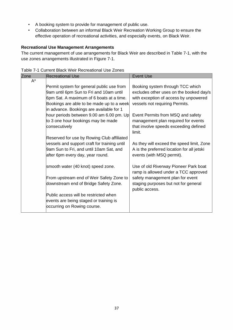
37
• A booking system to provide for management of public use.
• Collaboration between an informal Black Weir Recreation Working Group to ensure the
effective operation of recreational activities, and especially events, on Black Weir.
Recreational Use Management Arrangements
The current management of use arrangements for Black Weir are described in Table 7-1, with the
use zones arrangements illustrated in Figure 7-1.
Table 7-1 Current Black Weir Recreational Use Zones
Zone Recreational Use Event Use A*
Permit system for general public use from
9am until 6pm Sun to Fri and 10am until
6pm Sat. A maximum of 6 boats at a time.
Bookings are able to be made up to a week
in advance. Bookings are available for 1
hour periods between 9.00 am 6.00 pm. Up
to 3 one hour bookings may be made
consecutively
Reserved for use by Rowing Club affiliated
vessels and support craft for training until
9am Sun to Fri, and until 10am Sat, and
after 6pm every day, year round.
smooth water (40 knot) speed zone.
From upstream end of Weir Safety Zone to
downstream end of Bridge Safety Zone.
Public access will be restricted when
events are being staged or training is
occurring on Rowing course.
Booking system through TCC which
excludes other uses on the booked day/s
with exception of access by unpowered
vessels not requiring Permits.
Event Permits from MSQ and safety
management plan required for events
that involve speeds exceeding defined
limit.
As they will exceed the speed limit, Zone
A is the preferred location for all jetski
events (with MSQ permit).
Use of old Riverway Pioneer Park boat
ramp is allowed under a TCC approved
safety management plan for event
staging purposes but not for general
public access.
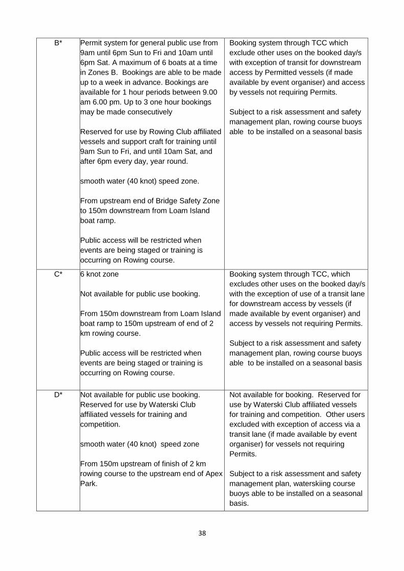
38
B* Permit system for general public use from
9am until 6pm Sun to Fri and 10am until
6pm Sat. A maximum of 6 boats at a time
in Zones B. Bookings are able to be made
up to a week in advance. Bookings are
available for 1 hour periods between 9.00
am 6.00 pm. Up to 3 one hour bookings
may be made consecutively
Reserved for use by Rowing Club affiliated
vessels and support craft for training until
9am Sun to Fri, and until 10am Sat, and
after 6pm every day, year round.
smooth water (40 knot) speed zone.
From upstream end of Bridge Safety Zone
to 150m downstream from Loam Island
boat ramp.
Public access will be restricted when
events are being staged or training is
occurring on Rowing course.
Booking system through TCC which
exclude other uses on the booked day/s
with exception of transit for downstream
access by Permitted vessels (if made
available by event organiser) and access
by vessels not requiring Permits.
Subject to a risk assessment and safety
management plan, rowing course buoys
able to be installed on a seasonal basis
C*
6 knot zone
Not available for public use booking.
From 150m downstream from Loam Island
boat ramp to 150m upstream of end of 2
km rowing course.
Public access will be restricted when
events are being staged or training is
occurring on Rowing course.
Booking system through TCC, which
excludes other uses on the booked day/s
with the exception of use of a transit lane
for downstream access by vessels (if
made available by event organiser) and
access by vessels not requiring Permits.
Subject to a risk assessment and safety
management plan, rowing course buoys
able to be installed on a seasonal basis
D* Not available for public use booking.
Reserved for use by Waterski Club
affiliated vessels for training and
competition.
smooth water (40 knot) speed zone
From 150m upstream of finish of 2 km
rowing course to the upstream end of Apex
Park.
Not available for booking. Reserved for
use by Waterski Club affiliated vessels
for training and competition. Other users
excluded with exception of access via a
transit lane (if made available by event
organiser) for vessels not requiring
Permits.
Subject to a risk assessment and safety
management plan, waterskiing course
buoys able to be installed on a seasonal
basis.
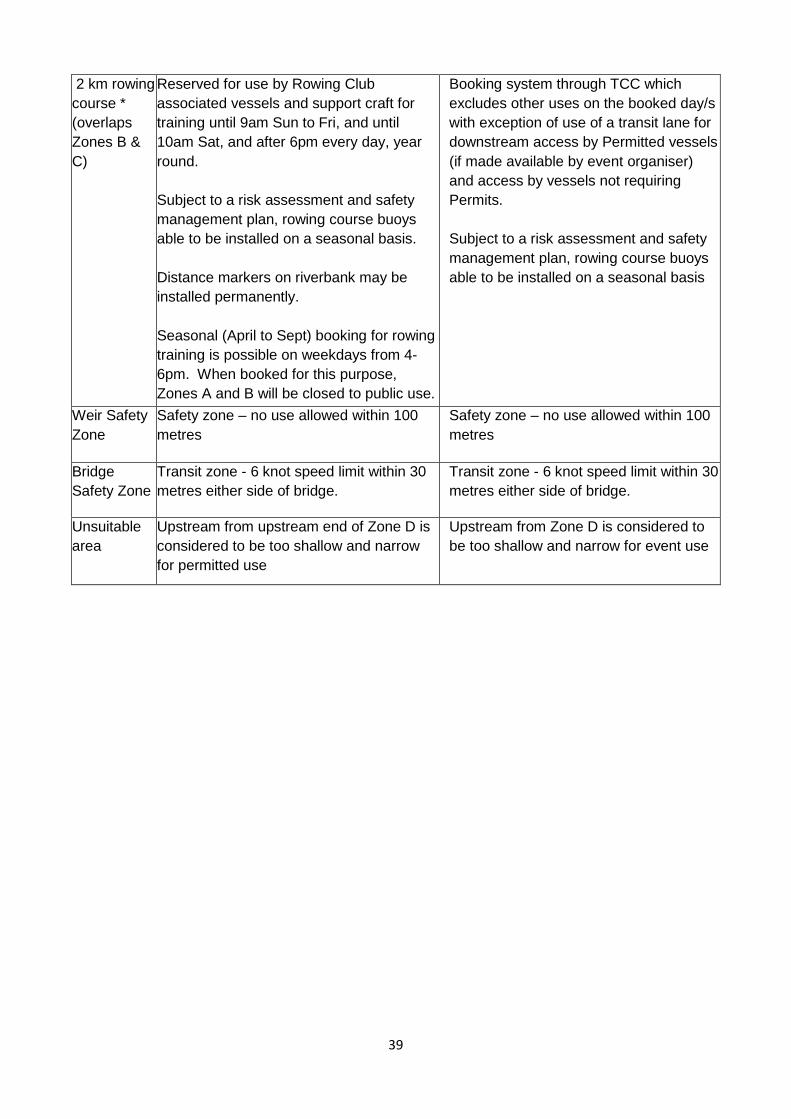
39
2 km rowing
course *
(overlaps
Zones B &
C)
Reserved for use by Rowing Club
associated vessels and support craft for
training until 9am Sun to Fri, and until
10am Sat, and after 6pm every day, year
round.
Subject to a risk assessment and safety
management plan, rowing course buoys
able to be installed on a seasonal basis.
Distance markers on riverbank may be
installed permanently.
Seasonal (April to Sept) booking for rowing
training is possible on weekdays from 4-
6pm. When booked for this purpose,
Zones A and B will be closed to public use.
Booking system through TCC which
excludes other uses on the booked day/s
with exception of use of a transit lane for
downstream access by Permitted vessels
(if made available by event organiser)
and access by vessels not requiring
Permits.
Subject to a risk assessment and safety
management plan, rowing course buoys
able to be installed on a seasonal basis
Weir Safety
Zone
Safety zone – no use allowed within 100
metres
Safety zone – no use allowed within 100
metres
Bridge
Safety Zone
Transit zone - 6 knot speed limit within 30
metres either side of bridge.
Transit zone - 6 knot speed limit within 30
metres either side of bridge.
Unsuitable
area
Upstream from upstream end of Zone D is
considered to be too shallow and narrow
for permitted use
Upstream from Zone D is considered to
be too shallow and narrow for event use
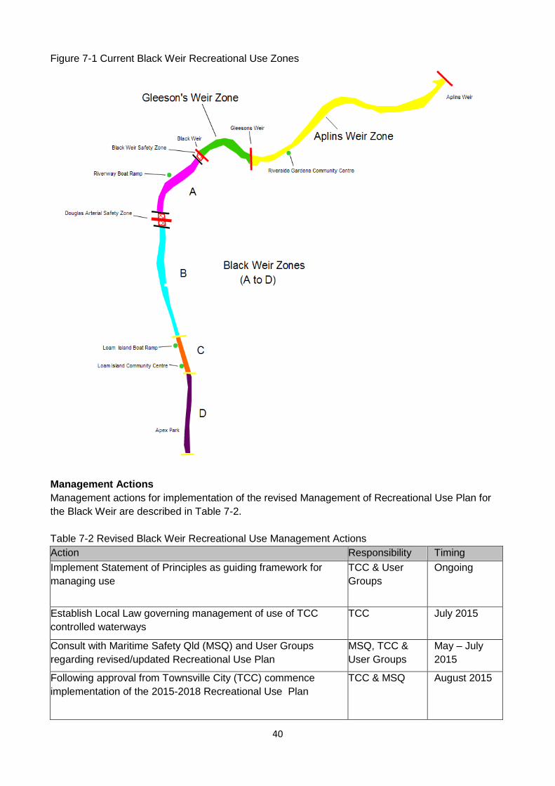
40
Figure 7-1 Current Black Weir Recreational Use Zones
Management Actions
Management actions for implementation of the revised Management of Recreational Use Plan for
the Black Weir are described in Table 7-2.
Table 7-2 Revised Black Weir Recreational Use Management Actions
Action Responsibility Timing
Implement Statement of Principles as guiding framework for
managing use
TCC & User
Groups
Ongoing
Establish Local Law governing management of use of TCC
controlled waterways
TCC July 2015
Consult with Maritime Safety Qld (MSQ) and User Groups
regarding revised/updated Recreational Use Plan
MSQ, TCC &
User Groups
May – July
2015
Following approval from Townsville City (TCC) commence
implementation of the 2015-2018 Recreational Use Plan
TCC & MSQ August 2015
41
Advise user groups of approval and implementation of
Management of Use Plan
TCC & User
Groups
August 2015
Make appropriate changes to the TCC web based booking
system, Loam Island boat ramp signage, signage for aquatic
events that involve shared Zones if required, and promotional
material to reflect revised Management of Recreational Use Plan
for the Black Weir
TCC July -
September
2015
The content of the revised Management of Recreational Use Plan appears in Appendix E.
8. Evaluation and Enforcement
8.1 Evaluation
There are differing levels of monitoring and evaluation required for the Ross River Waterway
Management System – Management of Use Plan based on;
- As yet undeveloped initiatives catalysed by the Management of Use Plan
- Implementation actions proposed in the Management of Use Plan
The level of monitoring and evaluation related to each of these points is discussed below;
As yet undeveloped initiatives catalysed by the Management of Use Plan
Measurement of the impact of the Management of Use Plan on as yet undeveloped initiatives will
require recording and appraisal of the processes involved in moving from a “no action” situation to
implementation of initiatives. This type of monitoring may need to be done on a retrospective basis
if the emerging initiative is not obvious during its gestation period. The assessment of the
effectiveness of the Management of Use Plan in enabling uses to develop being whether, and the
number of new uses that develop.
Implementation actions proposed in the Management of Use Plan
This is the level at which monitoring and evaluation is required as the actions and objectives are
defined. This includes receiving and responding to feedback from user groups and the public,
particularly when shared events/bookings occur, monitoring the booking of public permits and
commercial permits, and evaluating the regular and event booking systems.
8.2 Enforcement
The responsibility for enforcement of compliance to the intent and content of the management of
Use Plan, the Code of Conduct, and the Local Law related to the weirs is varied. Individuals are
responsible for compliance with speed regulations, use zones, and the permit process as well as for
respect for safety, the environment, and other weir users. Townsville City Council Regulatory
Officers can be contacted to deal with various issues relating to use in the weirs and will provide
education, warnings, or forward information/evidence to MSQ or The Water Police where required.
User groups are responsible for enforcing compliance by their members and at their activities and
events. Maritime Safety Queensland is responsible for compliance with safety regulations.
Townsville City Council is responsible for the enforcement of the Local Law. See Appendix G for the
amendment to Subordinate Local Law No. 4.
8.3 Review
42
It is the intent that the Management of Recreational Use Plan be reviewed every three years to
ensure it remains relevant to the evolving needs of the community. Accordingly, the next review
should occur in 2018.
9. Future Investigation and Potential Development
While outside of the scope of this plan, which is focused on the management of recreational use of
the Ross River Weirs, there are several current operational arrangements and potential
infrastructure improvements that should be investigated, their viability assessed, and changes to
arrangements and/or implementation of infrastructure development considered in the future in order
to enable ongoing improvement of access to and use of the Ross River Weirs by the community.
These include, but are not limited to;
- The arrangements under which access to the Ross Dam for recreational use is provided and
managed.
- The development of a second boat ramp on the Black Weir (preferably located to enable public
access to Zone A when other zones are booked for training and/or events)
- The development of infrastructure in Apex Park to accommodate community groups, and enable
access to and/or enhanced use of Zone D when training and/or events are being held in other
zones.
43
APPENDIX A – Ross River Waterway Management System - Strategic Management Areas
Management Area Strategy/Strategic Intent
Information Governance,
communication
and awareness
Using the Framework from the Strategy:
• Continue consistent communication and dissemination of information with the
Ross River Waterway Management Group; and
• Provide effective communication and dissemination of information to relevant
internal and external stakeholders.
Condition
assessment
Determine, in relevant detail, current condition and values of the land and
vegetation, and any other relevant features, in the vicinity of the Ross River
and tributaries, including erosion assessment and habitat values. This will
provide baseline data for planning and ongoing monitoring and evaluation.
Cultural heritage Determine the extent of Traditional Owner issues and interest in the plan area
and the potential for integration of Traditional Owner use and management
with non-indigenous management practices.
Management
objectives
Determine the environmental values, desired environmental outcomes and
water quality and other objectives for the study area, including potential
arrangements for a coordinated water quality monitoring program. Links to the
Creek to Coral initiative and emerging networks.
Recreation Aplin’s and
Gleeson’s Weirs
Develop a management of recreational use plan for the weirs including
desirability of access by powered boats and other recreational activities.
Recreational use
management for
Black Weir
Develop a management of use plan to accommodate a diversity of
recreational activities, while ensuring that the activity does not compromise
the environmental quality and experience of other users.
Recreational users
Code/s of Conduct
Establish guiding principles for members of recreational clubs for use of the
weir pools and associated facilities.
Environment
Aquatic weed
management
Review the weed management program for the Ross River weir pools with
reference to recreational management arrangements, environmental values
and new weed control methods.
Riparian
restoration and
management
Develop a coordinated approach to rehabilitation, re-vegetation and
management of natural areas and re-vegetation sites including strategic
prioritisation of rehabilitation and re-vegetation sites and definition of
management regimes.
Riparian zone pest
management
Development of a coordinated pest management plan for the riparian zone of
the Ross River plan area including tributaries, natural areas and open space
and parkland.
Stormwater quality
management
system
Facilitate a coordinated approach to stormwater quality management by
Council. Potential outcomes include; recommendations for environmental
management conditions associated with development and construction; water
sensitive urban design as an integral part of new developments, and a
combined program to retrofit stormwater drains with gross pollutant traps.
Erosion Manage the amount of erosion in order to prolong the life of constructed
amenities and control structures and minimise the impact on the environment.
44
APPENDIX B - Open Space for Sport & Recreation Guidelines
"Open Space for Recreation and Sport: Planning Principles" was developed in 1998 as a guide for
local government planner preparing planning schemes, or components of planning schemes,
including strategic plans and development control plans.
This document identifies State Government interest in recreation and sport management, and
ensuring these activities are identified, protected and managed. Planning schemes must integrate
state and regional interests.
Planning Policies within the document include:
• Recreational Setting Diversity
• Natural Landscape Features
• Sustainability of Recreation
• Undeveloped Open Space
• Recreation and Sport in Rural Areas
• Open Space Fragmentation
• Cross Boundary Strategic Planning
• Regionally Significant Open Space
• Regional Recreation and Sport
• Open Space Standards
• Charging for Public Parks and Infrastructure and Priority Infrastructure Plans
• Multiple Uses of Open Space
• Redevelopment/ Recycling of Land for Recreation and Sport
• Ecotourism and Outdoor Recreation
• Compatible Recreation Activities
• Recreation and Adjacent Land Uses
• Facility Location
• Co-Location of Facilities
• Non-Motorised Recreation Trail Networks
• Connectivity of Recreation Areas
• Waterways and Riparian Corridors.
The Planning Principles and Implementation Notes, 2003 highlights a number of important
considerations for the ongoing management of the Ross River as an important recreational, sport
and open space resource.
1. Allowing for recreational setting diversity within an area to provide the widest possible
options for recreational activity by ensuring all landscape types are incorporated in the public
open space network. By using the Recreation Opportunity Spectrum (ROS) for each site
along the river, a continuum of opportunity classes can help managers to identify the range
of recreation opportunities that visitors to the recreational site can participate in. Recreation
settings, hence, are the physical, social and managerial aspects that define a particular open
space, therefore, recreational settings cannot be static due to the modification that occurs
over time of the determining factors and values. This ensures that the settings are sensitive
to the change over time to the diversity and values of the community, however, they are
resistant to short term trends.
2. Open space can be multi-purpose eg. natural environment and recreational activities,
45
through ensuring that the activities are compatible and appropriately managed. This aims to
avoid negative impacts on the affected environment, ensuring the receiving environment has
sufficient capacity to sustain natural process and that the activity does not impact on the
natural attributes and diversity of the environment.
3. The need for cross boundary management. Each Council currently has individual sport and
recreation management plans. Improved coordination is required to ensure; the continuity of
outdoor recreational networks; improved user access through compatible policies and
practices and protection of the resource from inappropriate and incompatible land uses in
adjoining local government areas, and finally, to ensure that recreational management
issues with cross local government boundaries are dealt with in a coordinated and
complementary way.
4. Adoption of the River and environs within the Planning Scheme as open space rather than a
function of adjacent development.
5. Consideration of Regionally Significant Open Space, land which is regionally significant for
any open space function. Local governments should identify, protect and manage land of
strategic importance for regional open space. The land identified should be accompanies by
a statement of site significance to enable decisions to be made regarding a range of
compatible land uses and appropriate development (if any) adjacent or within particular
regional open space areas.
To ensure that ad-hoc planning and management of the recreational sites along the Ross River
does not occur, it is recommended that the Recreational Opportunity Spectrum (ROS) be used as a
framework for planning and managing the outdoor recreational activities and resources. The main
purpose of the ROS is to ensure that a diverse range of experiences can be had through the
recreational opportunities by allocating a variety of settings, which are biophysical, social and
managerial (Clark & Stankey, 1979; Stankey & Wood, 1982; QLD Dept of Sport and Recreation
2001).
Recreation Settings are a combination of the following factors:
Biophysical Attributes:
• Terrain;
• Type and access to and within:
• Number and type of built structures present;
• Plant community;
• Animal community:
• Smells caused by natural features (eg flowering plants, rain, drying algae after floods etc)
• Sounds caused by natural features (eg water falls, surf, bird song, wind); and
• Area of available landscape/seascape.
Social Attributes
• Total number of people present;
• Activities of the people present;
• Sounds caused by machinery and the activities of people;
• Smells caused by the machinery and the activities of people; and
• Number of people present in a social group and their behaviour.

46
Managerial Attributes
• Ownership and management arrangements for the site;
• Set of regulations/ rules/bylaws operating at a site;
• Landscaping and facility design and standards;
• Frequency of interaction with onsite enforcement, educational management, and
maintenance staff; and
• Number and obtrusiveness of signs.
For this system to work a comprehensive recreational planning and management study must be
completed which comprises of a site-by-site analysis using either the ROS or a similar system
(landscape Classification System (LCS) devised by Batt and Warin.
47
APPENDIX C – Traditional Owner Contact Details
Traditional Owner Groups
There are two Traditional Owner groups that need to be consulted with respect to the Ross River.
They are the Bindal and the Wulgurukaba.
Bindal
There are 5 Bindal family groups: Ross, Smallwood, Hegarty, Lymburner and Stanley. The family
groups have a list of nominated spokespersons that are required to be consulted for Cultural
Heritage and development projects.
Note: There are 2 Hegarty family contacts that represent two factions of the same family group.
Wulgurukaba
The designated contact point is the Wulgurukaba Aboriginal Corporation (WAC).
48
APPENDIX D - Consultation Summary Information
The 2015 revised version of the Ross River Management System – Management of Recreational
Use Plan involved consultation with key stakeholders and user groups including;
Organisation Contact
Townsville City Council Rob Hunt – Water Services
Gavin Lyons – Community and Environment
Andrew Hannay – Integrated Sustainability Services
Don Gordon – Community Services
Ricky Bligh – Infrastructure Planning
Laura Vidmar - Community Recreation and Sport
Jonathon Orman – Community Recreation and Sport
Emma Featonby – Venues Officer
Ken Armitage – Maintenance Services
Tony Bligh – Legal Services
Quentin Owen – Local Laws Unit
Eulonda Bolger – Environmental Health
Townsville Waterski Club
Scott Keevers
Riverway Rowing Club Mark Budd, Wayne Roy, Corby Green
Australian Boating College NQ
and Aquadrenalin
Watersports
Jason Robinson
Maritime Safety Queensland Max Haste
NQ Personal Watercraft Club Allan Pike
Townsville and JCU Rowing
Club
Chloe Schauble, Graham Ward
Townsville Dragon Boat Club Libby Timmins, Beatrix McLean
Townsville Kayak Club Hans Pruess, Kai Simmons
49
APPENDIX E – Revised Management of Recreational Use
A. Black Weir
Review discussions were held between May-June 2015 with all relevant internal and external
stakeholders. The final version of the 2015-2018 Management of Recreational Use Plan will be
submitted to TCC for approval.
The revised plan for the management of recreational use is based on a Statement of Principles
(Appendix F), use management systems/processes, a use zone structure, and other management
actions as follows:
• A web based permit booking system for management of general public recreational use on
Black Weir. To ensure a balance of safety and access, are for a maximum of 4 boats at a
time in Zone A and 6 boats at a time in Zone B. Bookings are able to be made up to a week
in advance. Bookings are available for 1 hour periods between 9.00am and 6.00pm Sunday
to Friday and 10.00am to 6.00pm Saturday. Up to 3 one hour bookings may be made
consecutively;
• A calendar of events to provide scheduling and management of organised activities on Black
Weir;
• A Black Weir Recreation Working Group involving user groups and TCC to ensure the
collaborative scheduling and management of organised activities on Black Weir, and to
provide a forum for Maritime Safety Queensland to communicate with regarding use related
safety issues. This is to function as an ‘email group’ that can openly discuss items with
Council and other user groups;
• Use of the TCC booking system for events;
• Use of the TCC Commercial Permit system for the management of commercial use;
• Smooth water (40 knot) speed use in Zone D, from 150m upstream of the Loam Island
Recreation Centre to the upstream end of Apex Park, for exclusive use only for organised
waterskiing activity and installation of course markers;
• Exclusive use of the Black Weir by Rowing Club affiliated vessels and support craft for
training until 9.00am Sunday to Friday, and until 10.00am on Saturday, and after 6.00pm
every day, year round;
• Unpowered vessels and motorised fishing craft are able to access the river at any time
without a permit;
• The intent of Townsville City Council when allocating space for event bookings, is that the
safest and most suitable space be used for the nature of the activity and event involved;
• Recognition that although rowing vessels and their support craft may exceed 6 knots, and
therefore the speed limit in 6 knot zones, the limit is intended to control the speed of the
public’s permitted powered vessels that are being used for waterskiing for safety reasons,
and not to restrict use by rowing vessels or their support craft;
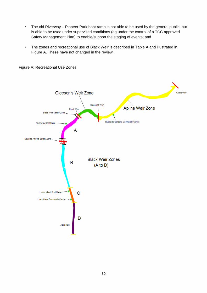
50
• The old Riverway – Pioneer Park boat ramp is not able to be used by the general public, but
is able to be used under supervised conditions (eg under the control of a TCC approved
Safety Management Plan) to enable/support the staging of events; and
• The zones and recreational use of Black Weir is described in Table A and illustrated in
Figure A. These have not changed in the review.
Figure A: Recreational Use Zones
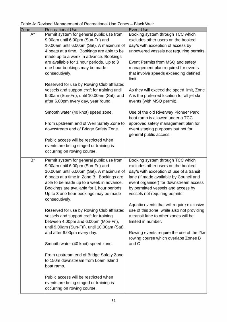
51
Table A: Revised Management of Recreational Use Zones – Black Weir
Zone Recreational Use Event Use A* Permit system for general public use from
9.00am until 6.00pm (Sun-Fri) and
10.00am until 6.00pm (Sat). A maximum of
4 boats at a time. Bookings are able to be
made up to a week in advance. Bookings
are available for 1 hour periods. Up to 3
one hour bookings may be made
consecutively.
Reserved for use by Rowing Club affiliated
vessels and support craft for training until
9.00am (Sun-Fri), until 10.00am (Sat), and
after 6.00pm every day, year round.
Smooth water (40 knot) speed zone.
From upstream end of Weir Safety Zone to
downstream end of Bridge Safety Zone.
Public access will be restricted when
events are being staged or training is
occurring on rowing course.
Booking system through TCC which
excludes other users on the booked
day/s with exception of access by
unpowered vessels not requiring permits.
Event Permits from MSQ and safety
management plan required for events
that involve speeds exceeding defined
limit.
As they will exceed the speed limit, Zone
A is the preferred location for all jet ski
events (with MSQ permit).
Use of the old Riverway Pioneer Park
boat ramp is allowed under a TCC
approved safety management plan for
event staging purposes but not for
general public access.
B* Permit system for general public use from
9.00am until 6.00pm (Sun-Fri) and
10.00am until 6.00pm (Sat). A maximum of
6 boats at a time in Zone B. Bookings are
able to be made up to a week in advance.
Bookings are available for 1 hour periods
Up to 3 one hour bookings may be made
consecutively.
Reserved for use by Rowing Club affiliated
vessels and support craft for training
between 4.00pm and 6.00pm (Mon-Fri),
until 9.00am (Sun-Fri), until 10.00am (Sat),
and after 6.00pm every day.
Smooth water (40 knot) speed zone.
From upstream end of Bridge Safety Zone
to 150m downstream from Loam Island
boat ramp.
Public access will be restricted when
events are being staged or training is
occurring on rowing course.
Booking system through TCC which
excludes other users on the booked
day/s with exception of use of a transit
lane (if made available by Council and
event organiser) for downstream access
by permitted vessels and access by
vessels not requiring permits.
Aquatic events that will require exclusive
use of this zone, while also not providing
a transit lane to other zones will be
limited in number.
Rowing events require the use of the 2km
rowing course which overlaps Zones B
and C
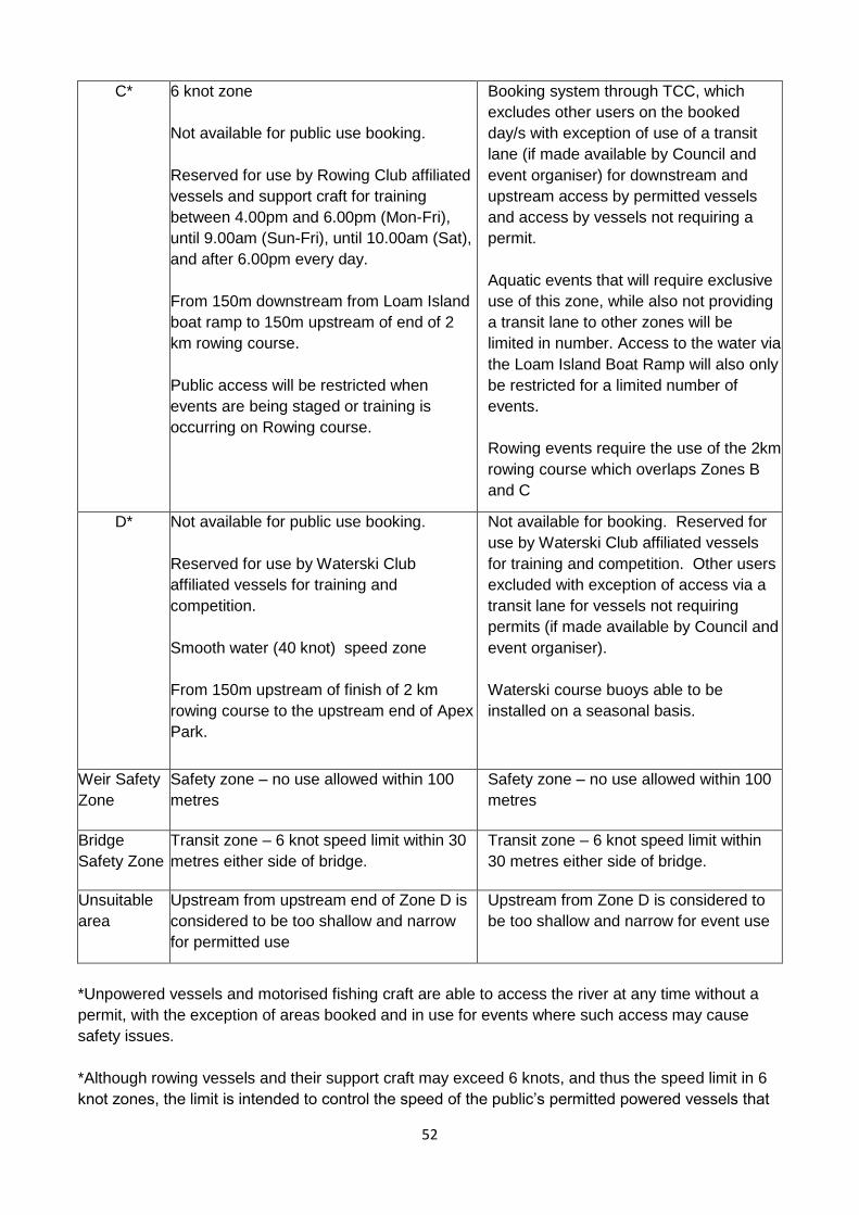
52
C*
6 knot zone
Not available for public use booking.
Reserved for use by Rowing Club affiliated
vessels and support craft for training
between 4.00pm and 6.00pm (Mon-Fri),
until 9.00am (Sun-Fri), until 10.00am (Sat),
and after 6.00pm every day.
From 150m downstream from Loam Island
boat ramp to 150m upstream of end of 2
km rowing course.
Public access will be restricted when
events are being staged or training is
occurring on Rowing course.
Booking system through TCC, which
excludes other users on the booked
day/s with exception of use of a transit
lane (if made available by Council and
event organiser) for downstream and
upstream access by permitted vessels
and access by vessels not requiring a
permit.
Aquatic events that will require exclusive
use of this zone, while also not providing
a transit lane to other zones will be
limited in number. Access to the water via
the Loam Island Boat Ramp will also only
be restricted for a limited number of
events.
Rowing events require the use of the 2km
rowing course which overlaps Zones B
and C
D* Not available for public use booking.
Reserved for use by Waterski Club
affiliated vessels for training and
competition.
Smooth water (40 knot) speed zone
From 150m upstream of finish of 2 km
rowing course to the upstream end of Apex
Park.
Not available for booking. Reserved for
use by Waterski Club affiliated vessels
for training and competition. Other users
excluded with exception of access via a
transit lane for vessels not requiring
permits (if made available by Council and
event organiser).
Waterski course buoys able to be
installed on a seasonal basis.
Weir Safety
Zone
Safety zone – no use allowed within 100
metres
Safety zone – no use allowed within 100
metres
Bridge
Safety Zone
Transit zone – 6 knot speed limit within 30
metres either side of bridge.
Transit zone – 6 knot speed limit within
30 metres either side of bridge.
Unsuitable
area
Upstream from upstream end of Zone D is
considered to be too shallow and narrow
for permitted use
Upstream from Zone D is considered to
be too shallow and narrow for event use
*Unpowered vessels and motorised fishing craft are able to access the river at any time without a
permit, with the exception of areas booked and in use for events where such access may cause
safety issues.
*Although rowing vessels and their support craft may exceed 6 knots, and thus the speed limit in 6
knot zones, the limit is intended to control the speed of the public’s permitted powered vessels that
53
are being used for waterskiing for safety reasons, and not to restrict use by rowing vessels or their
support craft.
*The release of water from the Ross Dam due to accumulated runoff and/or rain may occur
seasonally and result in the closure of all areas of Black Weir to all use. Should that occur, access
will not be allowed to resume until a safety inspection of the weir occurs and it is declared safe for
use.
*As per maritime regulations, the use of jet skis on the Ross River is only allowed when towing a
water-skier, as a safety/support vessel, or as part of an MSQ permitted event.
B. Gleeson’s and Aplin’s Weirs
The current arrangements for managing the use of parks will be applied to the management of the
use of Gleeson’s and Aplin’s Weirs. The process used is a booking system administered by the
Community Services Department. The applicant makes contact and requests their use. The request
is checked to ensure there are no other bookings for the area. If there are no unresolvable issues
the request is approved and a booking agreement is sent to the applicant with the conditions of use.
Speed Limit
The current gazetted 6 knot speed limit will remain as it is not considered necessary to alter it.
Although rowing vessels and their support craft may exceed 6 knots, and thus the speed limit in 6
knot zones, the limit is intended to control the speed of the public’s permitted powered vessels that
are being used for waterskiing for safety reasons, and not to restrict use by rowing vessels or their
support craft.
Rowing
Rowing is an established and encouraged use in these weir pools. The pontoon at the Riverside
Gardens Community Centre is the property of the Townsville & James Cook University Rowing
Club. Use for regattas will be addressed by use of the booking system, where Council is notified of
events in advance and the weir is booked for use by the organisation staging the event. There is no
need to define zones in this section of the river. Townsville City Council has no objections to start /
finish and distance buoys and riverbank markers being installed on a permanent basis and
maintained by the rowing club in Aplin’s Weir.
Other Events
Other community groups that occasionally make use of these weirs will be managed by the booking
process.
C. Other Uses and Users
Un-Powered Watercraft
It is not anticipated that existing public access to the river for canoeing and other activities using un-
powered vessels will be affected with the exception of the use of the areas of the zones being used
during booked events. Adequate communication will be required to ensure the public is aware of
activities being staged.
Defence Force activities
Will be managed through use of the booking and public notification processes to ensure any
potential issues are addressed.

54
Commercial Use
A Commercial Permit from Council is required to use the river for a commercial purpose. This is the
same process that applies to use of Council land for commercial purposes as any operation will
require land-based access.
The general concept of commercial use is supported with any specific enterprises being
permitted conditional on the appropriate permissions and requirements being met including:
• Any regulatory obligations i.e. licences and permits;
• Suitable access and staging areas being available;
• Commercial sustainability of the venture; and
• No adverse social, economic or environmental impacts.
Future ecotourism or other commercial enterprises will need the approval of Townsville City Council.
Such use will be subject to the Commercial Permit process.
55
APPENDIX F – Statement of Principles – Use of Black Weir
MANAGEMENT OF BLACK WEIR IMPOUNDMENT
Statement of Principles
This document records the principles under which the council will regulate use of the water area
upstream of the Black Weir (The Black Weir Impoundment).
It will guide the creation of the Ross River Waterway Management Plan which further details the
conditions of use, and responsibilities of users, and relationship with the maritime safety regulations.
Statement of Principle
The Townsville City Council will maximise community use of the Black Weir Impoundment and
associated community assets to the greatest extent possible while maintaining an acceptable level
of safety for all users and minimising the likelihood of environmental harm.
Relevant Considerations
a) The Black Weir impoundment is a community space and should be available for community
use.
b) There is increasing competition for space and time on the Black Weir impoundment from
organised sporting groups and recreational users.
c) The competition for space and time on the Black Weir Impoundment obliges the council to
regulate use of the area.
d) Organised sport contributes to the growth and cohesiveness of a community.
e) Organised sporting uses are subject to a level of control by the organising bodies, which
results in those uses being conducted at lower cost and risk to the community and the
environment.
f) The Black Weir Impoundment is the only location in Townsville suitable for some sporting
uses.
g) There is significant investment in community infrastructure associated with the use of the
Black Weir Impoundment, including picnic and swimming areas, playgrounds, clubhouses
and equipment shelters, and regulation of use of the Black Weir Impoundment should seek
to both protect and maximise the return upon that investment.
Prioritisation of Use
When regulating the use of the Black Weir Impoundment, the Townsville City Council will allocate
space and time on the Impoundment in the following order of priority:
1. Organised Sporting Competitions
2. Training for Organised Sporting Competitions
3. Recreational uses.
Note: Townsville City Council aims to allow a fair amount of competition, training and recreational
use on the river, therefore the priority order can change depending on the current amount and
needs of each activity type.
This prioritisation will be achieved by:
1. Identifying the portions of the Black Weir Impoundment (the competition training areas), that
are necessary or highly desirable for the conduct of organised sporting competitions, and
giving priority (in both space and time) to the conduct of organised sporting competitions
upon those portions of the Impoundment.
56
2. Identifying the portions of the Black Weir Impoundment (the training areas), that are
desirable for the conduct of training for organised sporting competitions and the times at
which that training is generally conducted, and then giving reasonable priority (in both space
and time) to the conduct of training for organised sporting competitions upon those portions
of the Impoundment. If possible training areas will include relevant competition areas.
3. Identifying the portions of the Black Weir Impoundment (the recreation areas), that are most
appropriately allocated for recreational uses, either because they have significant community
recreation assets in close proximity, or because they are outside training and competition
areas, and giving priority to recreational users in those areas.
4. Maintaining a booking system for competition and training areas, and taking forward
bookings for those areas a minimum of six months in advance.
5. Maintaining a booking system for the recreation areas, and those parts of the competition
and training areas that are not booked for competition or training use, and making those
booking periods available to the general public for recreational use.
Competition and Training Areas
Based on their history of use of the Black Weir Impoundment, their commitment to its protection,
and their commitment to safety when using it, the Riverway Rowing Club and the Townsville Water-
Skiing Club are the recognised local organising bodies for rowing and water-skiing on the
impoundment.
Council has formed a group of key stakeholders comprised of representatives from internal and
external organisations including Council, Maritime Safety Queensland and key recreational user
groups. The purpose of these stakeholders will be to inform the Council’s decision making about
regulation of the competition and training areas with a focus on minimising conflict between users.
These stakeholders not have voting rights of any kind.
The council will work with Maritime Safety Queensland to put in place regulations (such as speed
limits) that will support the identified competition and training uses in the competition and training
areas.
The council will regulate activities in competition and training areas so that it is an offence to wilfully
interfere with approved (booked) competition or training activities.
If a competition or training area has been allocated long-term for use for a particular sport (e.g.
water-skiing or rowing), and the recognised organising body for that sport wishes to install non-
permanent infrastructure into the competition or training area (e.g. Slalom buoys or other course
markings), then the council will be inclined to approve the placement of that infrastructure provided
that:
1. the infrastructure does not unreasonably obstruct, or pose an unacceptable risk to, the use
of the competition or training area for recreational purposes;
2. the organising body complies with all laws relevant to the placement, maintenance, use and
removal of the infrastructure;
3. the organising body in writing acknowledges that the council will not be responsible to the
organising body for preventing or limiting unauthorised use of the infrastructure, nor liable to
the organising body for any damage caused to the infrastructure.
When there is an overlap of competition or training areas between different sports, the council will
work through the coordination group to make a decision about installation of infrastructure in those
areas.
57
Recreation Areas
The council recognises that:
• the allocation of priority to sporting uses on the Black Weir Impoundment will unavoidably
reduce the size of the dedicated recreational areas, and the times in which competition and
training areas are available to recreational users;
• it is to be expected that there will be increasing demand for sporting use of the Black Weir
Impoundment, which over time will further reduce opportunities for recreational use of the
area; and
• demand by recreational users will also increase.
The council will respond to this by:
1. examining opportunities to facilitate recreational use of other water-bodies in the Townsville
region;
2. employing a range of strategies to manage recreational demand upon the Black Weir
Impoundment, which may include:
• dedicated regulatory officers being on-site during periods of high demand to minimise
unauthorised users and therefore conflict with users who have made bookings;
• introducing a charging system for bookings during periods of high demand to
minimise under-utilisation of booked periods;
• requiring vessels to display a distinctive flag or marking that evidences that it is being
used during an approved booking (facilitating council and public recognition of
unauthorised users); and
• other strategies that will maximise recreational opportunities given the prioritisation of
sporting use.
Ross River Waterway Management Plan
The council will apply the principles set out in this document and work with the working group and
through public consultation to develop the Ross River Waterway Management Plan to detail the
conditions of use, responsibilities of users, and relationship with the maritime safety regulations
applicable to the Black Weir Impoundment and other water-areas on Ross River.
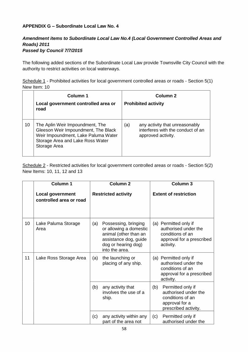
58
APPENDIX G – Subordinate Local Law No. 4
Amendment items to Subordinate Local Law No.4 (Local Government Controlled Areas and
Roads) 2011
Passed by Council 7/7/2015
The following added sections of the Subordinate Local Law provide Townsville City Council with the
authority to restrict activities on local waterways.
Schedule 1 - Prohibited activities for local government controlled areas or roads - Section 5(1)
New Item: 10
Column 1
Local government controlled area or road
Column 2
Prohibited activity
10 The Aplin Weir Impoundment, The Gleeson Weir Impoundment, The Black Weir Impoundment, Lake Paluma Water Storage Area and Lake Ross Water Storage Area
(a) any activity that unreasonably interferes with the conduct of an approved activity.
Schedule 2 - Restricted activities for local government controlled areas or roads - Section 5(2)
New Items: 10, 11, 12 and 13
Column 1
Local government
controlled area or road
Column 2
Restricted activity
Column 3
Extent of restriction
10 Lake Paluma Storage Area
(a) Possessing, bringing or allowing a domestic animal (other than an assistance dog, guide dog or hearing dog) into the area.
(a) Permitted only if authorised under the conditions of an approval for a prescribed activity.
11 Lake Ross Storage Area
(a) the launching or placing of any ship.
(a) Permitted only if authorised under the conditions of an approval for a prescribed activity.
(b) any activity that involves the use of a ship.
(b) Permitted only if authorised under the conditions of an approval for a prescribed activity.
(c) any activity within any part of the area not
(c) Permitted only if authorised under the
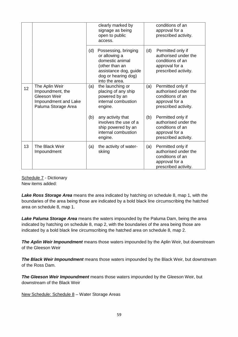
59
clearly marked by signage as being open to public access.
conditions of an approval for a prescribed activity.
(d) Possessing, bringing or allowing a domestic animal (other than an assistance dog, guide dog or hearing dog) into the area.
(d) Permitted only if authorised under the conditions of an approval for a prescribed activity.
12 The Aplin Weir Impoundment, the Gleeson Weir Impoundment and Lake Paluma Storage Area
(a) the launching or placing of any ship powered by an internal combustion engine.
(b) any activity that involves the use of a ship powered by an internal combustion engine.
(a) Permitted only if authorised under the conditions of an approval for a prescribed activity.
(b) Permitted only if authorised under the conditions of an approval for a prescribed activity.
13 The Black Weir Impoundment
(a) the activity of water-skiing
(a) Permitted only if authorised under the conditions of an approval for a prescribed activity.
Schedule 7 - Dictionary
New items added:
Lake Ross Storage Area means the area indicated by hatching on schedule 8, map 1, with the
boundaries of the area being those are indicated by a bold black line circumscribing the hatched
area on schedule 8, map 1.
Lake Paluma Storage Area means the waters impounded by the Paluma Dam, being the area
indicated by hatching on schedule 8, map 2, with the boundaries of the area being those are
indicated by a bold black line circumscribing the hatched area on schedule 8, map 2.
The Aplin Weir Impoundment means those waters impounded by the Aplin Weir, but downstream
of the Gleeson Weir
The Black Weir Impoundment means those waters impounded by the Black Weir, but downstream
of the Ross Dam.
The Gleeson Weir Impoundment means those waters impounded by the Gleeson Weir, but
downstream of the Black Weir
New Schedule: Schedule 8 – Water Storage Areas

60
Schedule 8 Water Storage Areas