Embed Size (px)
Citation preview
1
Author version: Man Environ., vol.34(2); 2009; 77-90
Management of Ports and Maritime Trade of Orissa and Andhra Pradesh during the Historical Period
Sila Tripati Marine Archaeology Centre National Institute of Oceanography Council of Scientific & Industrial Research Dona Paula, Goa 403 004, India Email: [email protected] Abstract
Along the 7516 km long coastline of India, several ports and trade centres have
existed from ancient times. Among them the ports and trade centres of Orissa and
Andhra Pradesh played a significant role in diffusing Indian culture to overseas countries
from the mid first millennium BC. The coastal geomorphology of Orissa and Andhra
favoured the establishment of a number of ports and trade centres, as evidenced by
archaeological, literary and other sources. The ports of this region had hinterland
connections by riverine and caravan trade routes. Several types of minerals and metals,
raw materials and finished artefacts were exported and imported from these ports. This
paper details the ports, trade routes and maritime contacts of Orissa and Andhra with
other parts of the world in relation to the maritime history of India, findings, tentative
dates and their management.
Keywords: Management, ports, maritime trade, Orissa, Andhra Pradesh.
2
Introduction Orissa and Andhra coast had a glorious maritime past and adventurous sailors
who traversed countries and islands situated beyond seas and oceans. On the great
maritime facades, there are different regions connected to hinterlands which are
favourable to sea traffic. The ports of Orissa and Andhra not only served for export and
import of merchandise but also spread of Indian culture in foreign lands. The mariners of
this region had established colonies in Rome, Arabian, African and Southeast Asian
countries which are attested through archaeological findings, art objects, epigraphical
and numismatic as well as literary sources.
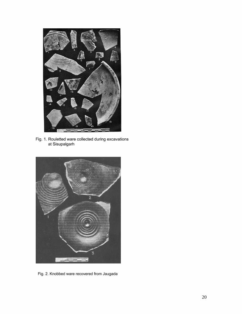
Sources for study of marine trade and ports of Orissa and Andhra The archaeological exploration and excavation finds such as Rouletted ware,
Knobbed ware, Northern Black Polished ware (NBP), silver punch marked coins, Roman
coins, Kharosthi scripts, semi-precious stone beads, Celadon ware, Chinese ceramic,
etc. along the Bengal, Orissa, Andhra and Tamil Nadu coast indicate that a network of
internal trade existed about 2000 years ago. The archaeological excavations at
Sisupalgarh, Manikapatna and Radhanagar of Orissa, Tamralipti and Chandraketugarh
of Bengal, Amaravati, Dantapur, Salihundam, Dharanikota, Kalingapatnam of Andhra
Pradesh have yielded Rouletted ware (Fig. 1). Knobbed ware has also been reported
from Jaugada (Fig. 2), Lalitagiri, Manikapatna, Kalahandi and Radhanagar of Orissa,
northern Andhra and coastal Bengal as well as Assam. Similarly, Rouletted ware and
Knobbed ware have been reported from Bali, Bangladesh, Java, Malaysia, Sri Lanka,
Thailand and Vietnam (Schenk 2006 and Glover 1996). The occurrence of Northern
Black Polished ware and silver punch marked coins along the port and coastal sites of
the east coast of India indicate the existence of coastal trade (Sila Tripati 2002). Semi-
precious stone beads have even been reported from Thailand, Indonesia, Burma,
Malaysia and Philippines. It appears that carnelian and glass were imported from India
to Southeast Asian countries and the finished products were exported to India again
through marine trade (Glover 1996). Single mast ship motif punch marked coins reported
from the Bengal coast belonging to the 3rd and 2nd centuries BC indicate the existence
of maritime trade (IAR 1987-88:111). The evidence of oceanic trade of Andhra region
can be recalled from the ship motif coins with single and double mast ships issued by
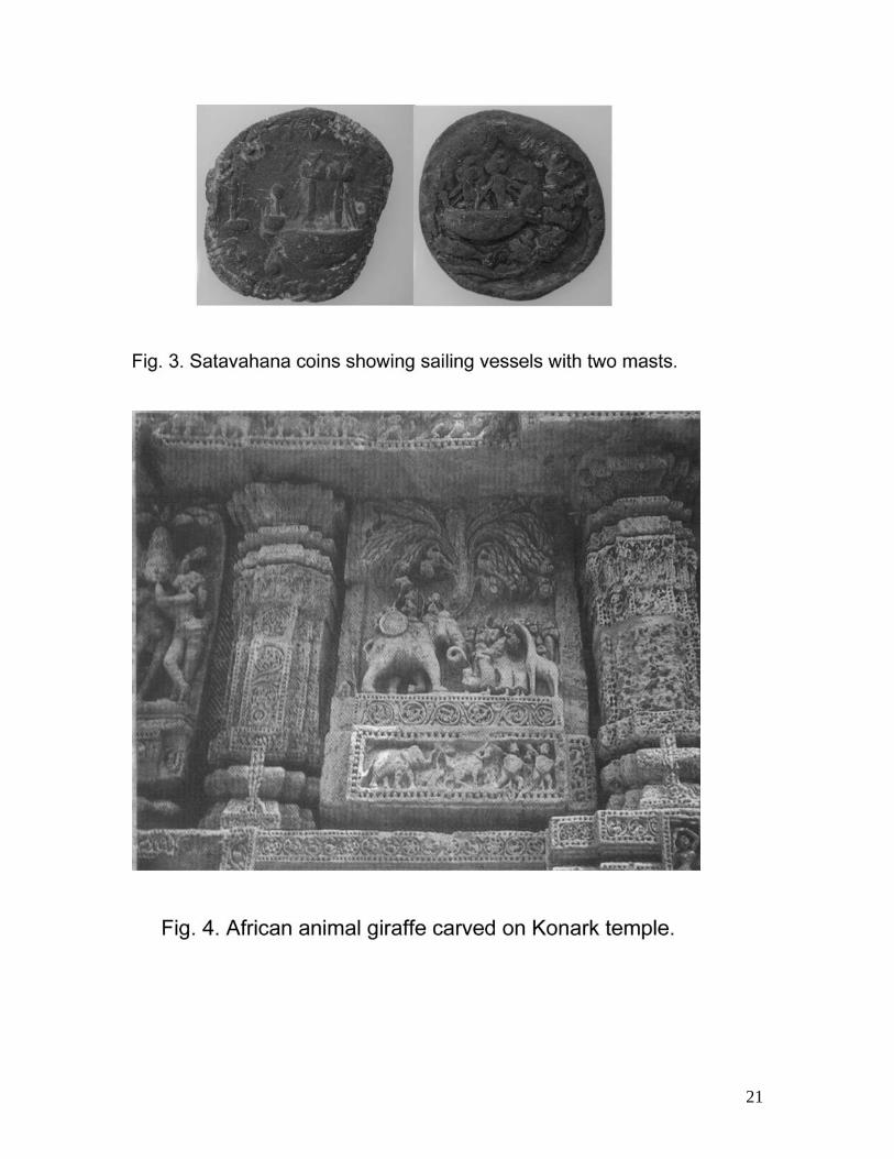
the Satavahanas (Fig. 3) and the Salankayanas (Sarma 1980). The finding of Roman
coins at many sites of Andhra, Bengal and Orissa show evidence of trade contact with
the Romans. Further, Chinese and Sri Lankan copper coins reported from
3
Khalkatapatna, Manikapatna and Kotchina in Indonesia prove the maritime trade
contacts between Orissa, Indonesia and Sri Lanka (Behera 1999).
The inscriptions of the 1st and 2nd centuries AD of Andhra Pradesh mention that
master mariners resided at Mahanagaparvata and Ghantasala. Some early Sanskrit
inscriptions have been recorded in western Java. According to Burnell (1878) and
Rawlinson (1916) the script resembles the ancient Telugu or Vengi script datable to the
middle of the 5th century AD. The Telaga Batu (AD 686) inscription of Indonesia
mentions Puhawang (ships captain), Vaniyaga (long distance or seafaring merchants)
and sthapaka (sculptors) as skilled people engaged in special tasks. The Kaladi (AD
909) inscription denotes Kalingas, Aryas, Sinhalese, Dravidians and Pandikiras as
wagga kilalan, meaning a group of foreigners. The Indonesian inscriptions mention the
Kalingas, Singhalese, Dravidians, Aryas, as banyaga meaning foreign traders and a
merchant guild called banigrama (Ardika 1999). The East Javanese and Balinese
inscriptions frequently use the term banigrama (Sanskrit Vanigrama) meaning a
merchant guild.
The artists and sculptors carried their ideas and innovations to other places and in
return they brought some new ideas, which can be gleaned from the art evidences of
Orissa and Andhra. The cultural and religious contacts of Orissa and Andhra with Java
and Indonesia can be traced from the early historical period onwards in which Buddhism
played a significant role. Traces of early Buddhism having the influence of Andhra and
Orissa have been found in various places of Southeast Asia. The images of Buddha
found at Pong Tuk of Siam (Thailand), Bangoen (Borneo), Palembang (Sumatra) and
the bronze images of Buddha found at Pong Tuk and Bangoen resemble the Amaravati
style. Buddha images of Amaravati style have also been found at Jamber in Eastern
Java. The Burmese traditions indicate that the Salankayanas of Vengi were responsible
for the spread of Buddhism in Burma (Ayyer 1987). Similarly, the Buddha and
Boddhisattava images of Borobudur, Indonesia and Orissa have common features (Sila
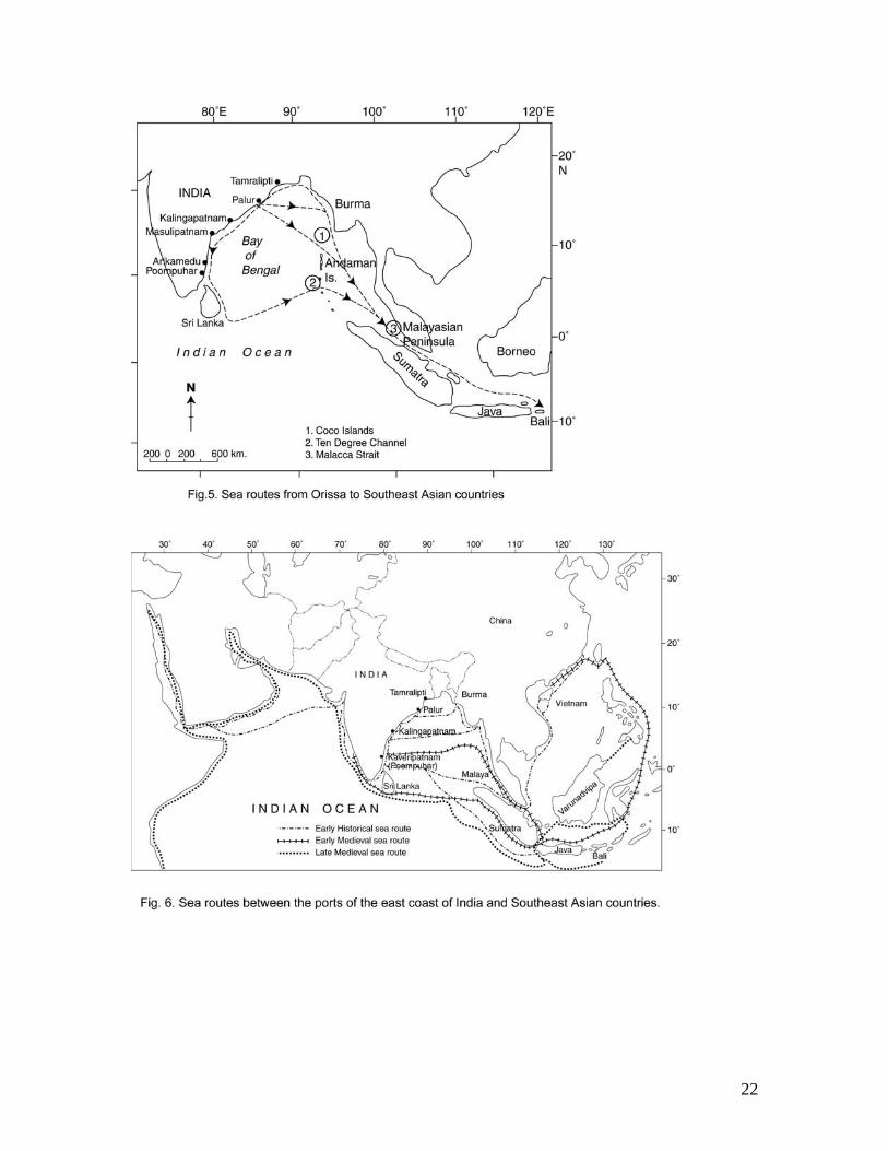
Tripati 2000). The depiction of a giraffe on the wall of Konark temple of Orissa (Fig. 4)
shows the contact of Orissa with Arab merchants who were responsible for bringing this
animal from Africa to the east coast of India as well to China.
Maritime trade and trade routes The maritime trade can be classified under 3 categories: (a) inland water
transport (b) coastal transport (c) overseas transport. All these three are interrelated.
Similarly, the maritime trade of Orissa and Andhra depended upon the networking
4
facilities linked with other trade routes and ports of India. The surplus agrarian and
industrial products were exported to Southeast Asian countries and beyond. The jewels,
elephants, ivory and textiles exported from the ports of Orissa and Andhra were highly
appreciated in foreign countries (Warmington 1974). Silver, woollen clothes and spices
used to be imported by Orissa and Andhra from other countries. As it is not known
whether trade and commerce was under any state policy, however, it is presumed that
trade and commerce was under private enterprise. Several terms related to trade are
found in ancient Indian texts: guilds (sreni), nigama or nikama were exchange centres,
(sahaya) association; the trading communities are known as vanijas and setthis which
have been derived from grhapatis who were rich households of land owners and
banigrama meaning a merchant guild (Thapar 2002 and Ray 2003). Definitely, there
would have been regional variation in organisation of trade. Due to divergent political
systems in ancient India it is presumed that the trade and other related aspects were
owned by private enterprise but overall controlled by the king.
In olden days, overseas trade was not possible without halting at intermediate
places for replenishment of water and food. Sailors sailing from the east coast of India to
Southeast Asian countries used the Nicobar Island as a halting station. Sailors,
merchants, artists, sculptors and missionaries came from different parts to the nearest port
and sailed to Southeast Asia and other countries following different sea routes (Fig. 5).
The ports of embarkation were Palur, Kalingapatnam, Tamralipti, Masulipatnam and
Poompuhar from where ships sailed across the Bay of Bengal to the coasts of Southeast
Asia and the Far East. Ships going to Java from the ports of Orissa and Andhra returned
directly to Sri Lanka and other ports on the east coast of India (Fig. 6). Further, these
ships took a course to the northeast from Java to reach Canton. This trade route was
generally followed by the merchants who traded with the countries of the West and the
East (Prasad 1977).
Port and Harbour The word ‘port’ has been derived from the Latin word ‘Portus’ meaning gateway.
Thus a port can be defined as a gate or entrance from the sea to land or land to sea, a
place where one form of transport is changed to another constituting a link in the chain
of transport. A ‘harbour’ can be defined as a sheltered area of the sea in which vessels
could be launched, built or taken for repair or could seek refuge at the time of storm or to
provide facilities for loading and unloading of cargo and passengers. Thus, the term port
is used to indicate a harbour where facilities such as stores, landing of passengers and
5
cargo etc. are added. In general it can be stated that a port includes a harbour or in
other words every port is a harbour but the reverse is not true.
Ports of Orissa Ptolemy (AD 150) in his Geography of Ancient India, mentions vividly the ports of
ancient Orissa namely Nanigaina (Puri), Katikardama (Kataka or Cuttack), Kannagara
(Konark), mouths of the rivers Manada (Mahanadi), Tyndis (Brahmani), Dosaron
(Baitarani?), Adams (Subarnarekha?), Minagara (Jajpur?) and Kosamba (Pipili or
Balasore), which had overseas trade relations with other countries (Mc Crindle 1985).
But Ptolemy did not refer to the other ports of Orissa such as Tamralipti, Manikapatna,
Palur, Che-li-ta-lo and Khalkatapatna (Fig. 7), which also played a dominant role in the
maritime history of Orissa. Similarly, the ports of Andhra such as Kalingapatnam,
Dantapura, Pithunda, Dharanikota, Kottapatnam, Masulipatnam, Motupalli (Fig. 8) etc.
played a significant role in diffusing Indian culture to the overseas countries from first
millennium BC onwards. Of all these ports, some were active from very ancient times
and continued to be so for long periods. Some ports became prominent during a
particular period and perished or lost their significance subsequently, whereas other
ports were meant for internal trade. Some of the ports of Andhra and Orissa have been
identified with corroborating archaeological evidence whereas some ports mentioned in
literature cannot be identified due to a lack of substantial evidence.
Tamralipti (Tamluk) was a Dronimukha port located at the confluence of the sea
and the Rupanarayana River. Vessels sailed regularly to Burma, Ceylon, Malaya
Peninsula and other Southeast Asian countries from Tamralipti. In the days of Asoka
(273-232 BC), Indian Missions to and from Ceylon passed through Tamralipti port.
Archaeological excavations have unearthed copper coins and terracotta figurines
datable to the Sunga period (3rd century BC), Rouletted ware and other objects like
sprinklers indicate the overseas contact of Tamralipti with the Romans. A considerable
number of silver and copper coins bearing Buddhist symbols have recently been
discovered in the midst of debris from the crumbling banks of the river Rupanarayana
(Sila Tripati and Rao 1994).
Khalkatapatna is situated on the left bank of the river Kushabhadra and was a
port town of the Ganga dynasty (12th and 14th centuries AD). The excavations at
Khalkatapatna (IAR 1984-85: 56-60) brought to light a brick jelly floor, which might have
served as a loading and unloading platform. Chinese Celadon ware, Chinese porcelain
with blue floral design on white background and egg-white glazed ware, besides glazed
6
chocolate ware of Arabian origin and dark grey and red slipped ware of indigenous origin
pottery were recovered from the excavations. The shapes include bowls, basins, vases
and miniature pots and all are wheel turned. The other antiquities include
arecanut-shaped beads of terracotta, fragments of bangle of glass and copper,
terracotta animal figurines, a miniature copper bowl and one complete and one fragment
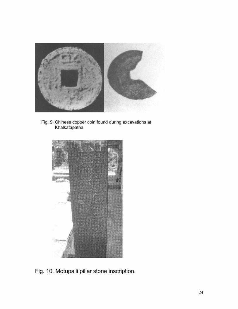
of Chinese copper coin datable to the14th century AD (Fig. 9). The circular copper coin
has a square perforation in the centre and legend in Chinese characters. The finds
belong to a single culture period which can be dated between the 12th and 14th
centuries AD and the period falls under the Imperial Gangas of Orissa. No structural
remains have been encountered in the habitational area (Sinha 1992).
Manikapatna was a flourishing port situated along the Chilika Lake. The
excavations (1989-1993) brought to light Indian Rouletted ware, fragments of amphora,
red-glazed ware, Puri-Kushana coins and a Kharosthi inscription on a potsherd
belonging to the Early Historical Period. In the upper levels, Chinese Celadon ware
made of jade green celadon occurred in huge quantity. Other finds are a damaged
Chinese copper coin with a square perforation in the centre (Nigam 1993). These
findings signify that Manikapatna had trade contacts with Arabia, Ceylon, China and
Rome from ancient times. The discovery of Shasamalla's coins from Manikapatna in
Orissa, Polonnaruwa in Sri Lanka and Kotchina in Indonesia, prove a maritime network
linking coastal Orissa, Sri Lanka and Sumatra. Manikapatna continued as a port till the
18th century. Recent explorations brought to light terracotta ringwells on the shore of
Chilika at Manikapatna which were submerged during high tide and exposed in low tide
(Sila Tripati and Vora 2005). Huge quantities of Chinese ceramics are also encountered
at the same site. The Brahmanda Purana describes Chilika as an important centre of
trade and commerce. Thousands of ships having a number of masts and sails were
sheltered in the lake. Some of the ships had curvilinear towers with three to five stories.
Ships used to go to Java, Malaya and Ceylon from the Chilika port (Singh 1982). The
lake was very deep and was connected to the sea through a wide mouth, which provided
easy berthing for the sea going boats and ships. Ptolemy refers to Paloura as an
important port of Kalinga country and a 'point of departure' (apheterion) for ships bound
for Sumatra, Java, Pegu, Burma and some parts of Malay Peninsula and Indonesia.
Paloura or Palur is identified with modern Palur in the Ganjam district of Orissa and was
located at the southern tip of Chilika Lake. The archaeological explorations in 1984-85 at
Palur and the adjacent areas have yielded red ware bowls with flaring rim having a ledge
7
on the exterior and a fragmentary terracotta dabber datable to 12th-14th century AD in
an area of half a square kilometre in sand dunes (IAR 1984-85: 56-60).
Ports of Andhra Pradesh Kalingapatnam, the ancient port city of Kalinga, is situated at the mouth of the river
Vamsadhara. The Chicacole grant (Fleet 1984) of King Indravarman and Narasingapalli
plates (Majumdar 1984) of King Hastivarman of the Eastern Ganga dynasty refer to
Kalinganagara, the capital city situated near the seashore. Explorations at Kalingapatnam
revealed megalithic Black and red ware along with black and grey ware treated in kaolin
paint under a black slip, red slipped ware, Rouletted ware, bricks of 44x22x8 cm, a stupa
and habitational mounds at Kalingapatnam and Nagarlapet (IAR1976-77: 10). The
excavations in the stupa mound between 1977-78 and 1979-80 brought to light a wheel
plan stupa, megalithic black and red ware, micaceous black ware etc; and also included a
number of Gupta period gold coins (Rao 2002). Pre-stupa occupation of Kalingapatnam
has been dated to 300 BC. Scholars are of the opinion that the sea washed out
Kalingapatnam and some remains can be noticed in the nearshore region while the rest
has been silted up over the years (Rao 1971-72). The Korni Plates of Anantavarma
Chodaganga (Sitapati 1926) refer to Dantapura, situated on the southern banks of river
Vamsadhara approximately 6 km from Srikakulam Road Railway station. Ptolemy refers to
the apheterion immediately to the South of Palur, where the vessels were bound for the
Malay Peninsula. S. Levi mentions that Dantapura was a trade centre having contacts with
the other ports of India and Persia during the 6th century BC. Dantapura had trade contact
with Tamralipti, Burma, Ceylon and Far East countries (Law 1967). The excavations at
Dantavaktrunikota by the Department of Archaeology, Andhra Pradesh in 1994 revealed a
row of Buddhist stupas and ruins of brick structures as well an earthen rampart
surrounding the site. The pottery include Northern Black Polished ware (NBP), Rouletted
ware, grey ware, dull red ware, red slipped ware and knobbed ware spread over an area
of 500 hectares of land (Subrahmanyam 1994) showing the trade contacts of Dantapura
with other parts of India.
Pithunda was another flourishing port of Andhra. The Hathigumpha Inscription of
Kharavela (1st century BC) states that Kharavela invaded the coastal belt of Andhra and
captured Pithunda and renovated the port (Jayaswal 1983). The explorations at
Pithapuram (identified as Pithunda), 20 km north of Kakinada yielded brick structures,
sherds of Rouletted ware and Black and red ware from a mound datable to the Early
Historic Period. Bhattiprolu of Krishna district has also been identified with Pithunda of
8
the Hathigumpha inscription of Kharavela. Levi (1926) mentions that Pithunda was a
centre of textile industry in the region of Maisolia. The Jaina text Uttaradhyayanasutra
mentions that Pithunda had trade relations with Champa (modern Kampuchea) even in the
days of Mahavira and was a seat of Jainism (Sarma 1990).
The excavations at Dharanikota brought to light a rock-cut navigation channel of
15 feet depth and 70-85 feet width, connected with the river Krishna. The wooden wharf
was constructed at right angles to the navigational channel, which extended to a height
of 3.36 m. A brick structure was constructed close to the wooden wharf all along the
channel on its inner side and an earthen embankment was raised at the back. The
presence of a warehouse on the bank of River Krishna indicates Dharanikota as an
inland port of the early centuries of the Christian era (Raghavachary 1972-73). The
findings include glass earrings, glass bangles, glass objects, copper and lead coins,
black and red ware, NBP ware and sherds with Brahmi inscriptions (Ghosh 1989). The
presence of Rouletted ware, arretine ware, Roman amphorae, Roman coins and double
mast ship motif Satavahana coins testifies to its contacts with other parts of the world
(Sarma 1980). Several excavations, which were carried out at Dharanikota suggest that
Dharanikota was an inland port and Buddhist centre which flourished from 4th century
BC to 14th century AD.
Archaeological and inscriptional evidences testify that Motupalli, also known as
Desuya Konda Pattana, served as a port during the rule of the Satavahanas, Kakatiyas,
Reddys and Vijayanagars. It is situated near Bapatla in Prakasam district. The discovery
of Rouletted ware and stamped ware suggests that Motupalli served as a port during the
Early Historical Period (Reddy 1999). The inscription on a pillar in the premises of
Motupalli temple (Fig. 10) of Ganapatideva, the Kakatiya ruler, states that the lives of
both foreign and Indian mariners are treated as being as valuable as that of the ruler
Ganapatideva himself. Further, it provides a long list of import and export trade items
which invariably show the busy activities of this port. Motupalli had trade contacts with
Japan, China, Sri Lanka, Burma, Sumatra, Java and Borneo. Large ships were plying
from Motupalli having capacity of 200 to 300 passengers. Chinese ships such as Jongu,
Zu and Kakam visited Motupalli port frequently (Sree Padma 1992).
Ptolemy mentioned Kottapatnam port as Kottis. Presently it is a small village in
Nellore district of Andhra. Presently, the ancient port site is 500 meters away from the
seashore and an irregular shaped creek passes through this village. It appears that the
creek could be an artificial channel, which was dug probably for berthing of ships. The
9
findings include Rouletted ware, Roman glass pieces, stamped ware, Caolin pottery,
Porcelain, Chinese ceramics and glazed ware and the Ming dynasty coin (Fig. 12)
having Chinese script with a square hole (Rao 1994). The ancient habitational remains
in the region have been scattered over more than one kilometre. The archaeological
evidences indicate that Kottapatnam continued as a port from 3rd century BC to 15th
century AD (Rao 2001). In ancient times Machilipatnam was known as Masulipatnam
and Ptolemy refers to it as Maisolia. Masulipatnam was a point of departure of vessels
bound for Southeast Asian and West Asian countries. The inland trade route which
started from Masulipatnam, connected to Broach passed through Ter, Paithan and
Ajanta. The Indo-Roman trade activities continued through this route connecting the east
and west coasts of India. Ships laden with varieties of cotton cloth, yarn, silk, cowries,
semi precious stone, glazed ware, etc. sailed to Burma, Ceylon, Indonesia and other
countries. The port declined because of formation of sandbars, narrowness and shallow
water, which did not allow movement of bigger ships for handling the cargo.
Management of ports and trade The concept of port of ancient times is the same as it is in the present century.
During the historical period there was a system for management of ports and trade but
not much written evidence is available which can be broadly discussed. However, some
changes have been made and guidelines laid down in the management of ports and
trade which were not prevailing in olden days. Based on the present guidelines, olden
day management system can be reconstructed with available historical data. It appears
that the king controlled all operational activities of port and trade. Various kinds of taxes
were levied and collected from the merchants; safety and security was also provided to
them. Ports were established at strategic locations and connected with hinterlands. The
available information on this aspect has been compiled and discussed below:
Geomorphological features for the establishment of ports on Orissa and Andhra coast
The geomorphological features of different regions of India and their connection
with hinterlands favoured maritime trade. For example on the east coast, the large and
fertile plain of Orissa has arches towards the Bay of Bengal. The coastal plains of Orissa
are narrow in the north, wide in the middle and narrow in the south. The coastal region of
Andhra and Orissa is characterised by wide deltas. The monsoons are a great force in
shaping the shoreline features of Orissa and Andhra. The ports of Orissa and Andhra
owe their existence to the projection afforded by sand bars and pits. The beach features
10
work as natural breakwaters providing relatively sheltered anchorage to these ports. The
rivers of Orissa have created large deltas at their confluence with the Bay of Bengal.
Further, the flourishing deltas of Andhra coast have natural outlets, the valleys of the
rivers Krishna and Godavari (Ahmad 1972).
Types of ports In ancient times port establishments were found either on the sea front; mouth of
riverbanks and in case of lagoons, at the outlets to the sea. On the basis of their location
and geographical features the ports of India have been divided into various groups such
as littoral ports, estuary ports and tidal ports. The archaeological explorations and
excavations have yielded evidence that maximum numbers of ancient ports were located
at such locations where cargo can be handled easily and vessels can be anchored
safely.
Almost all littoral ports are exposed to the surf and the sea breeze. Along the
Orissa and Andhra coast there were several littoral ports. It was difficult for bigger ships
to come close to the ports because of their draught, sandbars and spits. Sometimes
bigger ships anchor far out at sea. In these ports small vessels were used for hauling
cargo. Estuary ports were established in river estuaries though there were problems of
depth and shifting of sand bank. The shifting of sand bank obstructs the navigation
channels. However, these ports provided proper shelter to vessels and handling of
cargo. Moreover, these ports facilitate the linking of both land and river routes. The
possibilities of developing ports on the littoral zone or estuary area depended on the
range of tides of the region. The magnitude of high tide in Andhra and Orissa region is
1.5 to 3 m. Under these circumstances bigger vessels control their movement in the port
area during high tide.
Further, to corroborate facts about the above type of ports, the ancient Indian
text, the Silpasastra mentions two types of seaports namely Pattana and Dronimukha.
Pattana were situated on the seacoast where cargo was loaded and unloaded. Even
today the place names ending with Pattana indicate a port name e.g. Manikapatna,
Visakhapatnam, Masulipatnam and Nagapatanam. On the other hand, Dronimukha
refers to a port situated near the confluence of the river and the sea. Dronimukha was
also a market place. Interestingly, the names of ports such as Dwarka, Tamralipti, Tondi
and Puhar also had the same meaning and these port towns had well-established
markets and hinterland connections (Roy 1994).
11
Structures for establishment of port and hinterland connections Besides the geographical considerations in installation of harbours and ports,
maritime structures play a vital role in maritime activities of the country. These include
boatbuilding yards, warehouses, landing places, boat shelters, causeways, channels,
wharves, jetties, embankments, breakwaters and moorings on the sea front (McGrail
1983). The recent archaeological explorations and excavations on the east coast of India
have brought to light the existence of wharves, warehouses, jetties and lighthouses at
Dharanikota (Raghavachary 1972-73), Arikamedu (Wheeler et al. 1946), Kaveripattinam
(Soundar Rajan 1994), Ganjam, Mahabalipuram and Chilika (Sila Tripati and Vora
2005). At Kaveripattinam, a brick platform (18.28 and 07.62 m) was found during
excavations datable to 3rd century BC, which might have served as a wharf. Brick walls
have been noticed on the bank of the river Ariyankuppam at Arikamedu, which are the
remnants of a warehouse. Probably the area adjoining the warehouse also served as a
dock.
The excavations at Dharanikota brought to light a rock-cut navigation channel of
15 feet depth at mid centre and the width at top is 85 feet and 70 feet at bottom,
connected with the river Krishna for loading and unloading of cargo. During high tide
ships were berthed at the wharf alongside the embankment. The wharf appears to have
been built of wooden planks and cross beams resting on huge posts. (Raghavachary
1972-73). It seems that almost all the seaports of India had some kind of a dockyard or
wharf for anchoring ships and hauling the cargo and merchandise.
In addition to the maritime structures, information is also available on the ancient
landing places of India both on the seacoast and riverbanks. The author of the Periplus
Maris Erithrei (AD 60-100) mentions that there were thirteen landing places along the
coast of India (Schoff 1974). The important landing places on the east coast of India
were Komar (Cape Comorin), Kolkhai (Korkai on the river Tambraparni in Tiruneveli),
Kamara (probably Puhar or Poompuhar), Poduke (probably Arikamedu near
Pondicherry), Sopatma (near Chennai) and Masalia (Masulipatnam) in Andhra Pradesh.
It is essential that ports should be located at places which can be approached
either by river or land routes which ships of various sizes can reach without any
hindrance; and storage as well as transport facilities of cargo should be available, etc.
Most of the major ports of ancient India had these facilities. The historical records
indicate that 165 ports existed along the coast of India in different periods of history.
Among them some were major whereas others were minor ports. The major ports of
12
Orissa and Andhra were Palur, Kalingapatnam, Dharanikota, Masulipatnam and
Manikapatna. These ports had network with riverine and minor ports along with
hinterland trade centres. Minor ports facilitated control of traffic on the coastal plains and
contacts with agrarian and other production centres in the local region.
Safety and protection of trade and traders The overall responsibility for efficient management of port and trade was vested
in the king. Several ships plied between the ports not only for trade and commerce but
also carried people and there was constant traffic. During voyages sailors and traders
faced different kinds of problems in mid sea, which included storm, cyclone, danger of
hidden rocks, sea animals and piracy. To overcome these problems and for safe and
secure maritime trade, rulers had taken measures which are evident from various sources.
For instance, to get rid of the piracy problem Asoka had issued a copper plate edict known
as Marine Edict for the Naga rulers, which was however, contemptuously set at naught by
those for whom it was meant (Mookerji 1912). Similarly, Kautilya's Arthasastra, (4th-3rd
century BC) lays down the functions of the navadhyaksha or Superintendent of ships,
who has manifold duties to perform. For instance, he was required to maintain records
called panyapattna-caritra abdhi pattanadhyaksa nibandha; he was also enjoined to
show ‘fatherly consideration’ to vessels in distress and allow half toll (shulka), or exempt
from toll altogether, merchandise damaged by water (Shamasastry 1967).
Further, in later period, the famous ‘abhaya sasana’ (charter of security)
(Hultzsch 1982) issued by king Ganapatideva AD 1244-45, throws a welcome light on
the care taken by the rulers of Andhra to encourage maritime trade. The inscription
assures safety to traders (abhaya Sasana) arriving from all continents (Svadesi and
Paradesis) risking the sea voyage and its hazards like storm attacks and shipwrecks.
The merchants traded in goods like camphor, rose water, ivory, pearls, silk and
arecanuts from Motupalli port. The levies (usually 1:30) on the items of import and export
have also been listed with great detail and speak of the flourishing international trade
from Motupalli port, which was provided with warehouses. The inscription mentions
several continents, islands, foreign countries and cities but specific mention of Chini
(China) is noteworthy.
The other inscription issued by Annapottu Reddi AD 1358 at Motupalli
encourages free trade with places all over the world. The inscription mentions that the
law of the state is applicable to the merchants on the sea and shore towns. The
merchants could move freely in any part of Motupalli. The levy (aputrika dendam) was
13
not applicable to foreigners. Foreigners could sell their merchandise to whomsoever they
liked and buy articles of their choice. The cloth for women was not to be levied. But for
other items of merchandise the duty was to be levied as before. This was the procedure
followed in the anjinanpugalidam or place for security to persons in distress (Srinivasan
1990).
Collection of taxes, Piloting and lighthouses It is evident that in ancient times the rulers collected revenue from the people by
way of various types of taxes for the benefit of the state; collection of tax from traders
was among them. Taxes were collected from sailors and traders at various places:
namely at the entrance of towns and markets, passes, ghats, river banks and ports. The
levying of taxes was not uniform. It varied from merchandise to merchandise. It is also
not known whether there was a variation in collection of taxes from local and foreign
merchants.
The Arthasastra of Kautilya and some inscriptions mention the collection of taxes
from the traders. The Arthasastra mentions different departments and officers concerned
with navigation, distribution of the duties and responsibilities of Navadhyaksha, who
exercised the duty of the superintendent of ships to inspect the accounts concerning
navigation on the sea, estuaries, lakes and rivers. Varying duties were levied on different
articles transported on board the ships. Fisheries and passengers had also to pay taxes.
The text also codifies certain regulations to be followed in naval and mercantile marine
affairs (Shamasastry 1967). Among the inscriptions, the Nanaghat inscription of the
Satavahana dynasty is most important. From the inscription it can be understood that
traders passed through Nanaghat to reach Godavari valley. Similarly, traders crossed
the Junnar pass to reach Konkan coast and at these locations taxes were collected from
traders. Orissa evidently derived considerable revenue from sea trade. The Bhaumakara
period (8th to 10th centuries AD) inscription refers to Samudrakara bandha (sea tax
gate) on the bank of Chilika Lake, where taxes were collected from the sea traders (Sila
Tripati 2000).
References to pilotage are available in ancient Indian texts. The Supparaka
Jataka mentions that after the perilous adventures on the sea off the port town of
Bharukaccha the vessels reached the port under the pilotage of a blind mariner. There
are no references to the difficulties of approach to the ports on the east coast of India.
However, evidence of lighthouses is available on the coast of Orissa, Andhra Pradesh
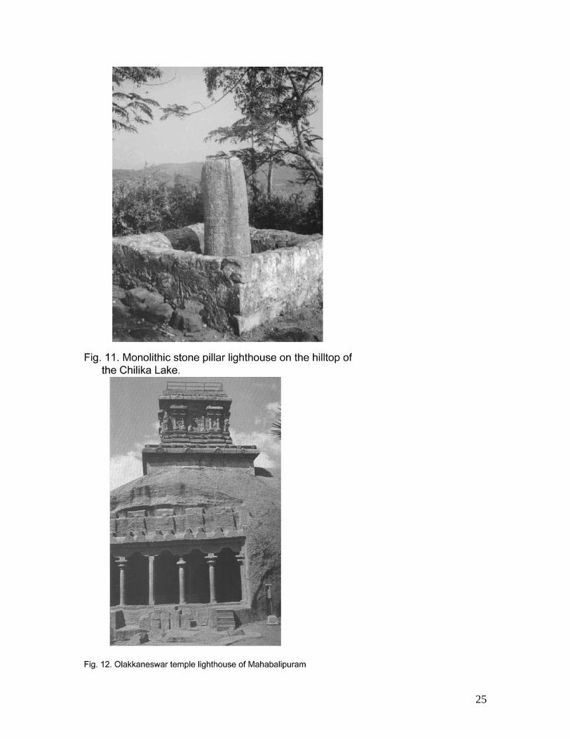
and Tamil Nadu. The hillock on the shore of Chilika is referred to as Deepa-Adia Pahada
14
(Hill of Light), where a 2 m high monolithic stone pillar is present, which might have
served as a lighthouse for seafarers from the historical period onwards (Fig. 11). The
Bay of Bengal can be seen from the southern side of the stone pillar. Bavikonda and
Thotlakonda, (near to Visakhapatnam), the Buddhist sites located on the hillocks which
lay very close to the seashore, might have served as a landmark for navigation. The
Olakkaneswar temple near the modern lighthouse of Mahabalipuram in Tamil Nadu is
the earliest representative of structural temples of the region. The Olakkaneswar or
Olakkanath (means ‘flame eye’) temple is situated on a hilltop in Mahabalipuram. On the
roof of the temple there is a shallow depression where a pot 1.5 feet high was kept with
oil. Every evening the oil was set on fire, the light of the fire used to guide the mariners
during night navigation. This system prevailed till the construction of lighthouses on the
same roof of the temple (Fig. 12).
Discussion and Conclusion The development and progress of a nation depends upon the use of available
natural resources, networking and management system. The management of water
resources is responsible for economic development. India is endowed with a 7516 km
long coastline connected with several rivers, creeks and inlets, which are suitable for
water transport system and development of ports. In olden days there were several ports
along the coastline of India among them some were major and others were minor.
Orissa and Andhra Pradesh had several ports, trade centres and a long maritime
history because of their navigable rivers, convenient anchoring and landing facilities,
which served sailors for better oceanic trade through the ages. Maritime trade facilitated
the transport of commodities and exchange of culture and religion. During the early
historical period mariners of the east coast of India were aware of the ports and trade
centres of Southeast Asia and they ventured into the open sea to reach Southeast Asia.
Moreover, they were aware of the direction of monsoon winds and currents which aided
them on their journey to Southeast Asia and back. Afterwards mariners changed the size
and carrying capacity of the ships and used bigger vessels. Subsequently, people
moved from one country to another, market places grew up and the economy of the
country progressed. Weak successors, poor economy, transfer of power, trade
monopoly, attack by neighbouring kingdoms etc. contributed to the decline of ports and
maritime activities of the region. Geological processes such as coastal erosion, sea level
changes, sedimentation, formation of sand bars and spits, cyclones, storms and tectonic
activities also seem to have been responsible for their decline.
15
It shows that in olden days ports developed at locations which were connected to
the hinterlands. It may be mentioned that the existence and distribution of small ports
along the coastline provided affordable facilities to overland connections in regional
areas and were a main hub for a nearby major port. Geographical factors played an
important role in setting up a number of maritime settlements and ports, which flourished
once but cannot be seen today. For example, the ports Manikapatna, Kalingapatnam,
Palur and Masulipatnam, which served for centuries together, have left only some traces
but it is difficult to locate the original port sites.
Several remnants of maritime structures have been noticed along the Orissa and
Andhra coast. These structures had been constructed in relation to the geomorphology
of the region. These maritime structures suggest how long a port or a trade centre was
in use and when it was abandoned. Sometimes scientific studies indicate the causes of
abandonment of sites and structures. The revival of ports at the confluences and the use
of riverine routes would provide easy transportation and better communication facilities
with hinterlands of India as in earlier days. A number of new ports have come up either
in the ancient port sites or in adjoining areas. It would be highly appreciable if the
present ports adopt the example of ancient port sites for posterity. Various kinds of
studies and explorations are conducted either in coastal or offshore regions for
industries. Some times explorations may bring archaeological findings or anomalies
which should be reported to the concerned authority for in-depth study and preservation.
Maritime structures and archaeological sites are our cultural heritage. The rapid
industrialisation activity along the coastal region may destroy the evidence of bygone
civilisation forever. Once the evidence is lost it can never be recovered. In view of this, it
is imperative to undertake extensive coastal surveys to locate and study the remains
which should be protected for coming generations.
Acknowledgements The author is thankful to the Director, National Institute of Oceanography and
Shri K.H. Vora, Scientist-in-Charge of Marine Archaeology Centre for their
encouragement and guidance. Thanks are also due to my colleagues for their co-
operation and suggestions in completing the paper, Shri R. Uchil and Pramod Pawaskar
for computer tracing of the figures and Shri S. B. Chitari for preparing the figures. This is
NIO’s contribution No. 4176.
16
References Ahmad, E. 1972. Coastal Geomorphology of India. New Delhi: Orient Longman. Ardika, I.W. 1999. Ancient trade relation between India and Indonesia, In Maritime Heritage of India, (K. S. Behera Ed.), pp. 80-89. New Delhi: Aryan Books International. Ayyer, S. 1987. (Reprint) Seven Vatteluttu Inscription from Kongu country, Epigraphica Indica 30: 95-102. Behera, K.S. 1999. Maritime activities of Orissa, In Maritime Heritage of India, (K.S. Behera Ed.), pp. 162-171. New Delhi: Aryan Books International. Burnell, A.C. 1878. Elements of South Indian Palaeography from 4th to17th century AD. London. Fleet, J.F. 1984. (Reprint) Ganga Grant of Indravarma, Indian Antiquary 13: 119-124. Ghosh, A. (Ed.), 1989. An Encyclopaedia of Indian Archaeology. Vol.II, New Delhi: Munshiram Manoharlal. Glover, I.C. 1996. The Southern Silk Road: Archaeological evidence for early trade between India and Southeast Asia, In Ancient trades and Cultural contacts in Southeast Asia, (Amara Srisuchat Ed.), pp. 57-94. Bangkok: The office of the National Culture Commission. Grover, I.C. 1996. Recent archaeological Evidence from early Maritime contacts between India and Southeast Asia, In Tradition and Archaeology, (H. P. Ray and J. F. Salles Eds.), pp. 129-158. New Delhi: Manohar Publishers Hultzsch, E. 1982. (Reprint) Motupalli pillar inscription of Ganapatideva AD 1244-45, Epigraphica Indica 12: 188-196. Jayaswal, K.P. 1983. (Reprint) Hathigumpha Inscription of the Emperor Kharavela, Epigraphica Indica 20: 71-89. Law, B.C. 1967. Historical Geography of Ancient India. Paris: Societe Asiatique de Paris. Levi, S. 1926. Pithunda, Pithuda, Pitundra, Indian Antiquary 55: 145-47. Majumdar, R.C. 1984. (Reprint) Narasingapalli plates of Hastivarman. Epigraphia Indica 23: 62-67. McCrindle, J.W. 1985. (Reprint). Ancient India as described by Ptolemy. New Delhi: Today and Tomorrow’s Printers and Publishers. McGrail, S. 1983, The Interpretation of Archaeological evidence for Maritime Structures, In Sea Studies, (Paw Annis Ed.), pp. 33-46. Greenwich: National Maritime Museum.

17
Mookerji, R.K. 1912. Indian shipping: A history of the sea-borne trade and maritime activity of the Indians from the earliest times. Bombay: Longmans, Green & Co. Nigam, J.S. 1993. A brief note on the excavation at Manikapatna. Bhubaneswar, (Unpublished). Prasad, P.C. 1977. Foreign trade and commerce in Ancient India. New Delhi: Abhinav Publication. Raghavachary, K. 1972-73. Dharanikota and its western contacts, Quarterly Review of Historical Studies 12 (1): 167-170. Rao, H.D. 2002. Kalingapatnam-Its importance on the History and Archaeology, District Srikakulam (Andhra Pradesh), In Puraratna, Emerging Trends in Archaeology, Art, Anthropology, Conservation and History, (C. Margabandhu, A.K. Sharma and R.S. Bisht Eds.), pp. 278-283. New Delhi: Agam Kala Prakashan. Rao, K.P. 1994. Kottapatnam, An early sea-port in southern Andhra Pradesh, Proceedings of Indian History Congress, 54th Session, Mysore: 829-831. Rao, K.P. 2001. Early trade and contacts between South India and Southeast Asia (300 BC-AD 200), East and West 51 (3-4): 386-394. Rao, R.S. 1971-72. The Historical Geography of Kalinga, Journal of the Andhra Historical Research Society 32 (1-4): 2. Ray, H.P. 2003. The Archaeology of Seafaring in Ancient South Asia. Cambridge: Cambridge University Press. Rawlinson, H.G. 1916. Intercourse between India and Western World from Earliest times to the Fall of Rome. Cambridge: Cambridge University Press. Reddy, P.K.M. 1999. Motupalli: New Archaeological evidence of foreign trade in early Andhra, Proceedings of Andhra Pradesh History Congress, 23:25-26. Roy, U.N. 1994. Dronimukha and Lothal, In The Role of Universities and Research Institutes in Marine Archaeology, (S. R. Rao Ed.), pp. 33-36. Goa: Society for Marine Archaeology. Schenk, H. 2006. The Dating and Historical value of Rouletted Ware, Zeitschrift fur Archaologie AuBereuropaischer Kulturen 1: 123-152. Sarma, I.K. 1980. Coinage of the Satavahana Empire. Delhi: Agam Kala Prakashan. Sarma, I.K. 1990. Ancient Andhra Ports, Religious Centres and Seafaring, Journal of Marine Archaeology 1: 19-23. Schoff, W.H. 1974. The Periplus of the Erythraean Sea. New Delhi: Oriental Books Reprint Cooperation.
18
Shamasastry, R. 1967. Kautilya’s Arthasastra. Mysore: Mysore Printing and Publishing House. Sila Tripati., and K.H. Vora 2005. Maritime heritage in and around Chilika Lake, Orissa: Geological evidences for its decline, Current Science 88 (7): 1175-1181. Sila Tripati. 2002. Early maritime activities of Orissa on the east coast of India: Linkages in trade and cultural developments. Man and Environment 27 (1): 117-126. Sila Tripati. and S. R. Rao 1994. Tamralipti: The Ancient Port of India, Studies in History and Culture, Journal of the Post Graduate Department of History, Berhampur University 2 (1): 33-39. Sila Tripati. 2000. Maritime Archaeology: Historical Descriptions of the Seafarings of the Kalingas. New Delhi: Kaveri Books. Singh, J. 1982. Prachin Utkala. Part- II, (Oriya), Orissa Sahitya Akademi, Bhubaneswar, 144-146. Sinha, B. K., 1992. Khalkattapatna: A small port on the coast of Orissa, In New Trends in Indian Art and Archaeology, (B. U. Nayak and N. C. Ghosh Eds.), pp. 423-428. New Delhi: Aditya Prakashan. Sitapati, G.V. 1926. Korni Plates of Anantavarman Chodaganga Deva, Journal of Andhra Historical Research Society 1: 40-48 and 106-124. Soundar Rajan, K.V. 1994. Kaveripattinam Excavations 1963-73 (A Port city on the Tamil Nadu coast. Memoirs of Archaeological Survey of India No. 90, New Delhi: Archaeological Survey of India. Sree Padma, B. 1992. Motupalli port in Medieval Times, Journal of Marine Archaeology 3: 37-41. Srinivasan, P.R. (Ed.), 1990. South Indian Inscriptions, Archaeological Survey of India, 26: 430. Subrahmanyam, B. 1994. Excavations at Dantapuram, Andhra Pradesh, Srikakulam District. Hyderabad: Department of Archaeology & Museums. Thapar, R. 2002. Early India from the Origins to AD 1300. Berkeley: University of California. Warmington, E.H. 1974. The commerce between the Roman Empire and India. New Delhi: Vikas Publishing House. Wheeler, R.C.M., A. Ghosh, and Krishna Deva 1946. Arikamedu: an Indo-Roman trading station on the east coast of India. Ancient India, Bulletin of the Archaeological Survey of India, No. 2: 17-124.
19
List of Figures
1. Rouletted ware collected during excavations at Sisupalgarh.
2. Knobbed ware recovered from Jaugada.
3. Satavahana coins showing sailing vessels with two masts.
4. African animal giraffe carved on Konark temple.
5. Sea routes from Orissa to Southeast Asian countries.
6. Sea routes between the ports of the east coast of India and Southeast Asian
countries.
7. Ports and excavated sites along the coast of Orissa.
8. Ports and trade centres of Andhra Pradesh.
9. Chinese copper coin found during excavations at Khalkatapatna.
10. Motupalli pillar stone inscription.
11. Monolithic stone pillar lighthouse on the hilltop of the Chilika Lake.
12. Olakkaneswar temple lighthouse of Mahabalipuram.
20
21
22
23
24
25