Embed Size (px)
Citation preview
Okanagan Region MANAGEMENT DIRECTION STATEMENT
March, 2003
for Chopaka East Site South Okanagan Grasslands
Protected Area
Ministry of Water, Land and Air Protection Environmental Stewardship Division
Chopaka East Site South Okanagan Grasslands Protected Area
Forward and Approvals Page Forward The Richter Pass area has long been a priority for conservation efforts in the Okanagan. The dry grasslands and open forests in this area represent one of the four most endangered ecosystems in Canada. Partners and programs of the inter-agency-supported South Okanagan - Similkameen Conservation Program and its participating programs and partners have worked to promote the conservation of the natural heritage of this area. Scientific research has complemented these conservation efforts, through universities and Provincial and Federal government sponsorship. The East Chopaka Site is one of 4 geographically separate but related sites (Chopaka West, Kilpoola, and Mt. Kobau) that form the South Okanagan Grasslands Protected Area. The 1850 hectare Chopaka East Site extends north towards Richter Lake and is bounded by undeveloped private lands on its east and west sides and by the International Boundary to the south. The Site’s ecological value is increased by the potential to participate in conservation management practices with the U.S. Bureau of Land Management (BLM), whose lands to the south contribute to a natural corridor from dry forest, through the arid grasslands and down to almost the Similkameen River. The Site plays an important role in the conservation of many red and blue-listed wildlife, plants and plant communities. The Site contributes significantly to the Protected Areas Strategy target for ecosystem representation and the protection of arid grasslands.
Table of Contents
Forward and Approvals Page ................................................................................................................i Introduction ............................................................................................................................................1 Purpose of the Management Direction Statement ....................................................................................1 Setting and Context ..................................................................................................................................1 Protected Area Attributes .....................................................................................................................3 Conservation ............................................................................................................................................3 Recreation/Tourism..................................................................................................................................3 Cultural Heritage......................................................................................................................................3 Scientific ..................................................................................................................................................4 Significance in the Protected Areas System.............................................................................................4 Other Land Uses and Interests..............................................................................................................4 Access ......................................................................................................................................................4 Existing Tenures, Alienations and Encumbrances ...................................................................................5 Adjacent Patterns of Land Use.................................................................................................................5 Aboriginal Interests ..................................................................................................................................5 Other Agency Interests.............................................................................................................................5 Public Stakeholder Interests .....................................................................................................................6 Role of Chopaka East Site .....................................................................................................................6 Management Commitments and Issues................................................................................................6 Management Direction from Previous and Ongoing Planning ................................................................6 Management Issues ..................................................................................................................................7 Management Direction ..........................................................................................................................8 Management Objectives and Strategies ...................................................................................................8 Integration with Other Land Use Planning Processes ............................................................................10 Consultation and Future Planning..........................................................................................................10 Zoning Plan ............................................................................................................................................10 Appendix I Acceptable Activities, Uses and Facilities in Chopaka East Site............................11 Appendix II Stakeholders Contacted for South Okanagan Grasslands Park............................13 Appendix III Red and Blue-listed Species Recorded in or Near Chopaka East Site...................16 Appendix IV Ecosystem Representation in Chopaka East Site ....................................................18
Chopaka East Site, South Okanagan Grasslands Protected Area MDS 1
Introduction
Purpose of the Management Direction Statement A management direction statement (MDS) provides strategic management direction for a protected area. A MDS also describes protected area values, management issues and concerns, management strategies focused on immediate priority objectives and directional statements from other planning processes. While strategies may be identified in the MDS, the development and implementation of these strategies is subject to funding. In addition, all development associated with these strategies within the protected area is subject to the BC Parks’ Impact Assessment Policy. This MDS was developed through direction received from the Okanagan-Shuswap Land and Resource Management Plan (OSLRMP), as well as comments from stakeholders and interest groups. The MDS is intended to provide direction and guidelines for future management of the Chopaka East Site.
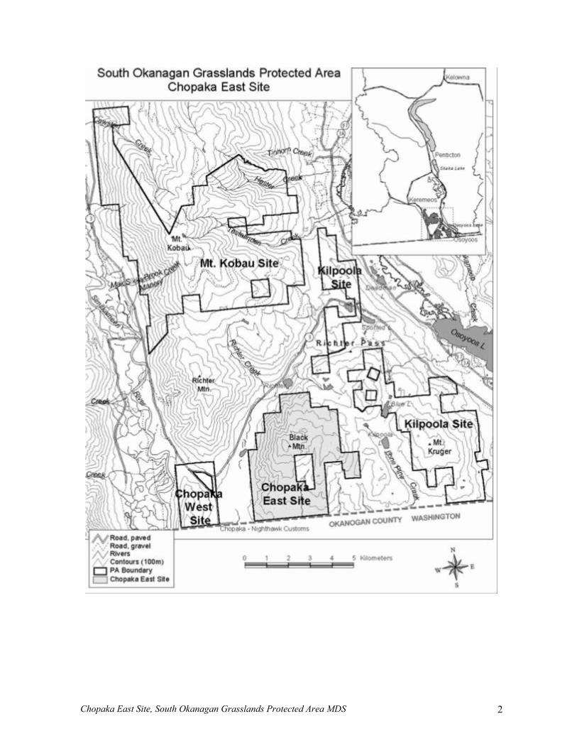
Setting and Context The provincial Protected Areas Strategy (PAS) provided the framework for identifying areas that would contribute towards ecological representation within the province. As part of that strategy, the provincial government undertook many strategic level regional planning initiatives (Strategic Land Use Plans), throughout the province. The Okanagan-Shuswap Land and Resource Management Plan concluded that a number of protected areas should be established to protect natural, cultural and recreational values. The LRMP Table used the Protected Areas Strategy as a guide in the selection of protected areas and in providing direction for their management. With respect to the South Okanagan Grasslands Protected Area, the OSLRMP plan recognized the primary need for conservation of its red- and blue-listed plants and animals. The South Okanagan Grasslands Protected Area was recommended for protection by the OSLRMP in 2000. It was formally established as a protected area on April 18, 2001 by Order in Council under the Environment and Land Use Act. The Park Act and regulations apply as if the protected area is a Class A provincial park. The intent is to transfer the protected area to Class A provincial park status by including it in Schedule D of the Protected Areas of British Columbia Act. The 1850-hectare Chopaka East Site is situated on Black Mountain, between Richter Pass and the International Boundary. The entire Site is within the Southern Okanagan Basin Ecosection and consists of the very hot, xeric subzones of the Bunchgrass (BGxh1), Ponderosa Pine (PPxh1), and Interior Douglas-fir (IDFxh1) biogeoclimatic zones. Eight of the province’s red-listed and six blue-listed plants and animals are known from the protected area.
Chopaka East Site, South Okanagan Grasslands Protected Area MDS 2
Chopaka East Site, South Okanagan Grasslands Protected Area MDS 3
Protected Area Attributes
Conservation • entirely within the South Okanagan Basin Ecosection, comprised of very hot and xeric
Bunchgrass (BGxh1), Ponderosa Pine (PPxh1) and Interior Douglas-fir (IDFxh1) biogeoclimatic variants
• over 40% is grassland or shrub steppe, almost 30% is open ponderosa pine forest (Appendix IV); these dry habitats are very fragile
Habitat Type BGxh1
(% of PA) PPxh1
(% of PA) IDFxh1
(% of PA) Total
Grassland 2.9 35.6 0.0 38.6 Sagebrush Shrub-Steppe 1.7 2.3 0.0 4.0 Rocky Habitats 1.0 12.8 1.6 15.4 Wetland 0.0 0.0 0.0 0.0 Riparian 0.1 1.2 0.0 1.3 Forest 0.0 11.5 29.2 40.8 Other 0.0 0.1 0.0 0.1 Total 5.7 63.4 30.9 100.0 Compiled from Terrestrial Ecosystem Mapping (1:20,000). More detailed habitat representation is tabulated in Appendix IV
• many of the red- and blue-listed plant communities identified for the Penticton Forest District
potentially occur in the Site, depending on range condition, including grassland/shrub-steppe, dry forest and riparian ecosystems (Appendix III)
• south-facing, dry, rocky slopes also provide critical wildlife habitats; alluvial fans on the west side, with steep, actively eroding gullies and rock faces, provide a wide variety of habitats in a small area
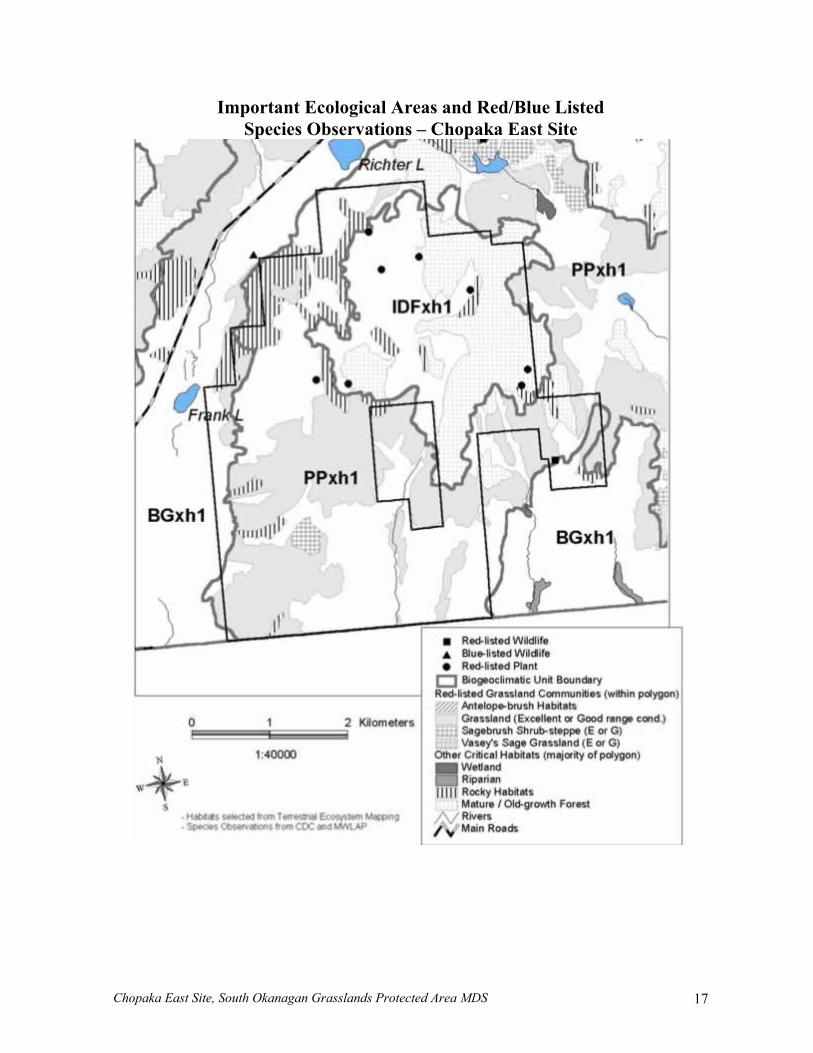
• six red-listed and six blue-listed wildlife species have been recorded in or adjacent to the Site (within 500 metres), and at least four red-listed plants species occur within the Site (Appendix III); additional species are expected to occur
• important mule deer winter range • best known site for rare dry ground lichens (cryptogams) with several species new to science,
due to relatively limited soil disturbance • an extensive wildfire occurred in 1994, burning through much of the grassland and forested
ecosystems on Black Mountain; the site was subsequently salvage-logged
Recreation/Tourism • nature appreciation and wildlife viewing, especially bird watching, are important recreation
activities • recreational use is moderate and influenced by the extent of roads • hiking, horseback riding and mountain biking are ongoing activities • hunting is valued but limited due to access and interspersed private lands • potential to contribute to wildlife viewing and nature study tours
Cultural Heritage • lack of systematic archaeological surveys, but sites should be present • the Site had insufficient information for a cultural heritage rating
Chopaka East Site, South Okanagan Grasslands Protected Area MDS 4
• traditional Aboriginal use unknown • may include early farm settlement
Scientific • site of a number of previous wildlife surveys (songbirds, small mammals and invertebrates) • history of range research and vegetation plots (two exclosures and two permanent plots present)
Significance in the Protected Areas System • contributes ecological significance to the South Okanagan Grasslands Protected Area, in
combination with three other Sites (Chopaka West, Kilpoola, Mt. Kobau) • the Site lies within the South Okanagan Basin (SOB) Ecosection, which is the fourth smallest
ecosection in the Province yet hosts the highest number of red- and blue-listed plant and animal species; the South Okanagan Grasslands Protected Area is the largest contributor of protected area in the ecosection accounting for 4,481 hectares (46.1 % ); the Site makes an important contribution to that protected in the South Okanagan Grasslands Protected Area
• consists entirely of provincially and regionally significant ecosystems, including the hottest and driest biogeoclimatic subzones in the province
Ecosystem Classification
Province (ha)
% within OSLRMP
% within existing PAs
% within Goal 1
% Protected (existing +
Goal 1)
% of Protected within
Chopaka East
% of Total within
Chopaka East
Ecosection 1 SOB 78739 100 NA 13.02 NA NA 2.3 Biogeoclimatic Unit 2 BGxh1 61913 100 0.7 4.1 4.8 14.9 0.7 PPxh1 110292 100 2.9 5.8 8.7 2.9 0.2 PPxh1a 4491 100 0.0 21.2 21.2 35.7 7.6 IDFxh1 * 241392 71 2.3 3.7 6.0 5.5 0.3
Sources of areas for area calculations: 1 Ecoregion mapping (1:250,000), MWLAP 2 BEC mapping (1:250,000), MOF 3 Multiple Accounts Analysis, OSLRMP * includes only Protected Areas within OSLRMP
• hosts large number of rare wildlife species significant in the province (six red-listed, six blue listed) as well as at least two red-listed plants; almost all Canadian observations of Lyall’s Mariposa Lily occur within the site; also potentially contains red-listed plant communities (e.g. big sagebrush – bluebunch wheatgrass)
• opportunities for nature study/interpretation of rare species/grassland values
Other Land Uses and Interests
Access Access is from Highway 3 at Kilpoola Estates via Kruger Mountain Road. This public road continues past Blue Lake to the northeast side of the Site. This section of the road, referred to here as Black Mountain road, continues southward and enters the private inholding. East of the Site, a non-status road (“Coulee Road”) branches to the south from the public road, entering the Site from the east and eventually joining Black Mountain road in the private inholding. Both roads provide access
Chopaka East Site, South Okanagan Grasslands Protected Area MDS 5
to the private inholding and adjacent private properties. Other non-status roads and trails, some used by tenure-holders and recreationalists, are present in the Site.
Existing Tenures, Alienations and Encumbrances All existing liens, charges, and encumbrances other than those applying to commercial logging, mining or energy exploration and development will continue to be authorized through issuance of park use permits (PUPs). This policy recognizes all existing Land Act tenures, special use permits (SUPs), water rights, trapping licences and other legal tenures and rights. Most tenure holders require motorized access into or through the Site. Tenure holders are included in Appendix II. There are several types of tenures in the protected area: • one water license • two registered traplines areas • a guide outfitter has a non-transferable sundry permit throughout the Site that is reviewed and
issued annually; the license will not be issued to another person when the present tenure holder decides to not actively guide in the area
• two ranch operations have pastures through Range Use Plans; range improvements consists mostly of fencing and livestock water developments
Untenured interests in the Protected Area include: • Canadian Helicopters has a long history of using the area for mountainous helicopter training
Adjacent Patterns of Land Use • private rangelands • to the south, across the International Boundary, is mostly public land administered by the Bureau
of Land Management
Aboriginal Interests • interests of the Okanagan First Nations are not known
Other Agency Interests • the South Okanagan – Similkameen Conservation Program has a long-standing involvement with
conservation and resource management on these lands; this Site should also be managed in close co-ordination with The Land Conservancy of B.C. and the Bureau of Land Management
• Canadian Wildlife Service is undertaking a five year sage thrasher habitat improvement project in the area; the Site provides critical habitat for this species
• Ministry of Forests manages existing grazing licenses, in conjunction with the Environmental Stewardship Division under a protocol agreement
• Ministry of Forests has a range exclosure and has conducted range research on the Site; important vegetation plots are situated within this Site
• Ministry of Forests assists the management of forest health but there are no concerns at this Site • Ministry of Forest’s Fire Protection Branch manages wildfire responses, prevention and assists
prescribed burns; this agency has concerns about fire response (require a pre-attack plan) and fire prevention activities
• US Forest Service will respond to fires adjacent to the International Boundary through the Canada-U.S.A. Fire Protection Agreement
• South Okanagan Similkameen Weed Committee provides a venue for cooperative weed control; weed control has traditionally been undertaken through rancher initiatives and the Ministry of Forests on these lands
Chopaka East Site, South Okanagan Grasslands Protected Area MDS 6
• Ministry of Transportation has one road (Kruger Mountain road) that enters the Site; Ministry of Transportation may wish to undertake fire abatement and weed control on their rights of way; there are no major road improvements planned for these roads in the near future
Public Stakeholder Interests The numerous stakeholders are listed in Appendix II. Overall interests include: • casual outdoor recreation (hiking, horseback riding, and mountain biking) • nature viewing (casual and club-sponsored) • recreational hunting • cultural and heritage values • nature conservation and ecosystem management (non-government groups and organizations) • fire management for ecosystem health and protection of adjacent private property • bluebird trail nest box program conducted by the Southern Interior Bluebird Trail Society • scientific research by universities and non-government organizations
Role of Chopaka East Site The primary role of the Chopaka East Site is to protect the very hot and dry grassland, shrub-steppe and open pine forests. Associated rock outcroppings are also very important wildlife habitats. Red- and blue-listed plants and wildlife depend on this area. Feature species are rare grassland birds, including the sage thrasher and grasshopper sparrow, and the rare Lyall’s Mariposa Lily. The Site contributes to the ecological integrity of the South Okanagan Grasslands Protected Area, in combination with the Chopaka West, Kilpoola and Mount Kobau sites. These combined holdings provide a unique opportunity for conserving expanses of low-elevation, arid grasslands. Cooperative management practices with the Bureau of Land Management that holds lands south of the border, and private properties adjacent to the Site, would increase the conservation values of the overall area. The Site may contain regionally significant archaeological sites and be of special value for traditional First Nations uses. Wildlife viewing, natural history interpretation and other limited-access recreation opportunities are ongoing. There are immense opportunities for improving these experiences through interpretation. Commanding views and other aesthetic values add to the visitor’s experience. The importance and sensitivity of this arid Site requires that recreational and other uses of the site are of low intensity and avoid impacting conservation values. Further ecological inventory and monitoring will be required to ensure that conservation objectives are being met.
Management Commitments and Issues
Management Direction from Previous and Ongoing Planning Management direction was originally provided through the now-defunct Oldtimers Coordinated Resource Management Plan (CRMP). High conservation values were first established through the South Okanagan Critical Areas Program (Erickson and Torrance 1989). Research and management strategies were developed and partly implemented by the South Okanagan Conservation Strategy (Hlady 1990). Subsequently, the former BC Environment’s Wildlife Branch established a Notation of Interest for conservation purposes over the Site in 1991. A summary of the area’s values, attributes, issues and habitat management recommendations was prepared for the South Okanagan Conservation Strategy (Bryan 1996). All of these initiatives provide guidance for ecological management directions.
Chopaka East Site, South Okanagan Grasslands Protected Area MDS 7
The OSLRMP provided statements of management direction for the interim management of the Site; these have been incorporated into the preparation of this MDS.
Management Issues The following are over-riding management issues that have been identified through previous documentation and preliminary consultation with agencies and stakeholders: • inadequate resource inventory of natural and cultural values to establish sensitive sites • inadequate knowledge of how human activities impact conservation values • fencing in disrepair, or burned in the recent fire, may be hampering good range management • need for increased public understanding of the conservation values and strategies • inappropriate access and activities (e.g. type, intensity, location, and timing) that are
incompatible with conservation objectives • impacts to ecological integrity from non-native plants (weeds) and animals • lack of adequate inventories, strategies, and resources to manage weeds • lack of detailed information for appropriate fire response and management • compatibility of activities on adjacent lands with protected area objectives • ability to monitor and enforce permitted uses • compatibility issues may exist or arise among uses of the Site • public desire for ongoing opportunities to participate in Site planning • consistent, fair, and timely management strategies to resolve new and outstanding issues in the
Site • lack of knowledge of First Nation values and traditional uses to appropriately manage these
interests The following table lists specific issues by theme requiring management action:
Theme Issue Protecting ecological
values • public appreciation of the Site’s conservation values • sensitive sites are not adequately identified, including adequate inventories
of rare fauna and flora • management of public motorized vehicle access • an undetermined effect of access and recreational activities on the protected
area’s soils, vegetation, and wildlife • impact of any future facilities on the aesthetic values of the Site • possible impacts of tenured uses • habitats degraded through past uses and management • weeds compromising the vegetative integrity of important habitats • non-native animals and feral cats and dogs impacting conservation values • fire response planning to protect ecological values (stands of sagebrush) • seral stage representation may not reflect natural disturbance regimes • forest encroachment into grasslands, ingress, and fuel loading; all resulting
from fire suppression • threat from human-caused fire
Managing recreational opportunities and
impacts
• access planning; safe, well-marked access routes that do not impact critical wildlife habitat, endangered species or livestock operations; ensure private lands are adequately posted along trails and fence lines
• increased fire hazards caused by increased public use • need for self-guided interpretive kiosks explaining the values, sensitivities,
and permitted uses of the Site
Chopaka East Site, South Okanagan Grasslands Protected Area MDS 8
Theme Issue • wildlife-human interaction hazard areas along hiking trails • safety hazards not adequately identified
Protecting cultural values
• cultural features not adequately identified (e.g. archaeology sites, pioneer ranch sites)
Recognized Tenures • concern about livestock-human conflicts and lack of awareness of tenure-holder rights and requirements (closing gates)
• lack of knowledge about appropriate grazing prescriptions that complement conservation objectives
• non-target, red-listed wildlife (i.e. badger) being trapped • water consumption potentially impacting wildlife and salmonid habitats
Aboriginal Involvement
• lack of First Nation involvement
Scientific • access for ongoing and future research and inventory compatible with conservation and recreation values
• upkeep of research facilities (e.g. range exclosures)
Management Direction
Management Objectives and Strategies The overall intent of this Site is conservation of the ecological and cultural values, while maintaining low-intensity recreation and nature appreciation activities. The following over-riding management strategies are critical to the preservation of the primary values of this Site (red- and blue-listed plants and animals, and ecosystem representation). Furthermore, these strategies are urgently required for delivery of the initial management direction and essential to future planning. Strategies are listed in order of priority. • Implement priority access management improvements (e.g. gates, signage) intended to protect
conservation and cultural values, while allowing acceptable uses and activities. • Work with the agencies and non-government organizations having interests in the area to
develop complementary land management strategies. • Develop interim pre-attack fire plan which reflects the conservation objectives. • Encourage awareness and support of the conservation objectives of the Site (e.g. workshops,
interpretative signage and material and press releases). • Document existing ecological information and identify gaps. Where ecological risks are greatest,
conduct ecological inventories and habitat assessments that will guide the development of management strategies. Special consideration may be required to protect extremely rare plants (e.g. Lyall’s Mariposa Lily).
• Conduct inventory of noxious weeds as required. Develop and implement a weed management plan, in cooperation with South Okanagan – Similkameen Weed Committee
• Collate existing knowledge of cultural features and values, and identify information sources as well as any information gaps and inconsistencies. Consult with the Okanagan First Nations to identify cultural sites and traditional values and activities. Identify existing and potential risks to these resources. Prepare management objectives to protect these interests.
• Pursue opportunities to collaborate with appropriate conservation projects and research being conducted in the Site.
• Develop interim plans for the management of non-tenured protected area uses (e.g. recreational activities). Interim plans are required to ensure, among other things, the protection of ecological and cultural values. These plans will include guidelines to address any potential conflicts with
Chopaka East Site, South Okanagan Grasslands Protected Area MDS 9
the various uses and between uses, and involve stakeholder consultation. Furthermore, the plans must recognize the need for adaptive management in the event of broad disturbance (e.g. wildfire).
• Conduct monitoring that can evaluate the effectiveness of management activities. Revise interim plans to reflect changes required to meet management objectives.
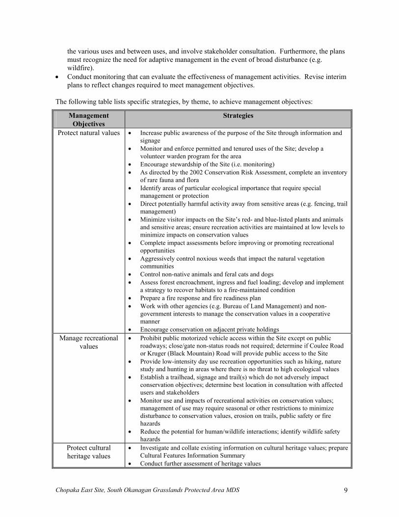
The following table lists specific strategies, by theme, to achieve management objectives:
Management Objectives
Strategies
Protect natural values • Increase public awareness of the purpose of the Site through information and signage
• Monitor and enforce permitted and tenured uses of the Site; develop a volunteer warden program for the area
• Encourage stewardship of the Site (i.e. monitoring) • As directed by the 2002 Conservation Risk Assessment, complete an inventory
of rare fauna and flora • Identify areas of particular ecological importance that require special
management or protection • Direct potentially harmful activity away from sensitive areas (e.g. fencing, trail
management) • Minimize visitor impacts on the Site’s red- and blue-listed plants and animals
and sensitive areas; ensure recreation activities are maintained at low levels to minimize impacts on conservation values
• Complete impact assessments before improving or promoting recreational opportunities
• Aggressively control noxious weeds that impact the natural vegetation communities
• Control non-native animals and feral cats and dogs • Assess forest encroachment, ingress and fuel loading; develop and implement
a strategy to recover habitats to a fire-maintained condition • Prepare a fire response and fire readiness plan • Work with other agencies (e.g. Bureau of Land Management) and non-
government interests to manage the conservation values in a cooperative manner
• Encourage conservation on adjacent private holdings Manage recreational
values • Prohibit public motorized vehicle access within the Site except on public
roadways; close/gate non-status roads not required; determine if Coulee Road or Kruger (Black Mountain) Road will provide public access to the Site
• Provide low-intensity day use recreation opportunities such as hiking, nature study and hunting in areas where there is no threat to high ecological values
• Establish a trailhead, signage and trail(s) which do not adversely impact conservation objectives; determine best location in consultation with affected users and stakeholders
• Monitor use and impacts of recreational activities on conservation values; management of use may require seasonal or other restrictions to minimize disturbance to conservation values, erosion on trails, public safety or fire hazards
• Reduce the potential for human/wildlife interactions; identify wildlife safety hazards
Protect cultural heritage values
• Investigate and collate existing information on cultural heritage values; prepare Cultural Features Information Summary
• Conduct further assessment of heritage values
Chopaka East Site, South Okanagan Grasslands Protected Area MDS 10
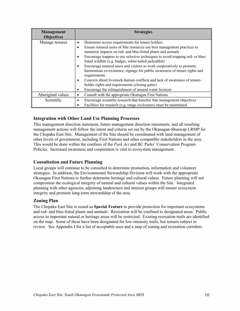
Management Objectives
Strategies
Manage tenures • Determine access requirements for tenure holders • Ensure tenured users of Site resources use best management practices to
minimize impacts on red- and blue-listed plants and animals • Encourage trappers to use selective techniques to avoid trapping red- or blue-
listed wildlife (e.g. badger, white-tailed jackrabbit) • Encourage tenured users and visitors to work cooperatively to promote
harmonious co-existence; signage for public awareness of tenure rights and requirements
• Concern about livestock-human conflicts and lack of awareness of tenure-holder rights and requirements (closing gates)
• Encourage the relinquishment of unused water licences Aboriginal values • Consult with the appropriate Okanagan First Nations
Scientific • Encourage scientific research that benefits Site management objectives • Facilities for research (e.g. range exclosures) must be maintained
Integration with Other Land Use Planning Processes This management direction statement, future management direction statements, and all resulting management actions will follow the intent and criteria set out by the Okanagan-Shuswap LRMP for the Chopaka East Site. Management of the Site should be coordinated with land management of other levels of government, including First Nations and other compatible stakeholders in the area. This would be done within the confines of the Park Act and BC Parks’ Conservation Program Policies. Increased awareness and cooperation is vital to ecosystem management.
Consultation and Future Planning Local groups will continue to be consulted to determine promotion, information and volunteer strategies. In addition, the Environmental Stewardship Division will work with the appropriate Okanagan First Nations to further determine heritage and cultural values. Future planning will not compromise the ecological integrity of natural and cultural values within the Site. Integrated planning with other agencies, adjoining landowners and interest groups will ensure ecosystem integrity and promote long-term stewardship of the area.
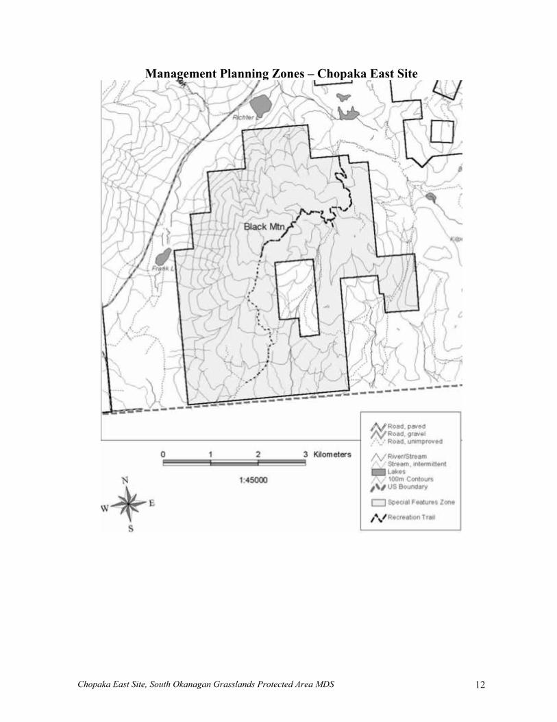
Zoning Plan The Chopaka East Site is zoned as Special Feature to provide protection for important ecosystems and red- and blue-listed plants and animals. Recreation will be confined to designated areas. Public access to important natural or heritage areas will be restricted. Existing recreation trails are identified on the map. Some of these have been designated for low-intensity trails, but remain subject to review. See Appendix I for a list of acceptable uses and a map of zoning and recreation corridors.
Chopaka East Site, South Okanagan Grasslands Protected Area MDS 11
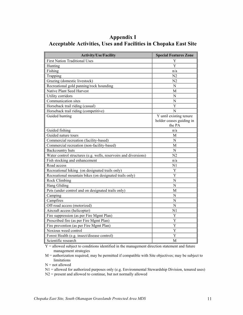
Appendix I
Acceptable Activities, Uses and Facilities in Chopaka East Site
Activity/Use/Facility Special Features Zone First Nation Traditional Uses Y Hunting Y Fishing n/a Trapping N2 Grazing (domestic livestock) N2 Recreational gold panning/rock hounding N Native Plant Seed Harvest M Utility corridors N Communication sites N Horseback trail riding (casual) Y Horseback trail riding (competitive) N Guided hunting Y until existing tenure
holder ceases guiding in the PA
Guided fishing n/a Guided nature tours M Commercial recreation (facility-based) N Commercial recreation (non-facility-based) M Backcountry huts N Water control structures (e.g. wells, reservoirs and diversions) N2 Fish stocking and enhancement n/a Road access N1 Recreational hiking (on designated trails only) Y Recreational mountain bikes (on designated trails only) Y Rock Climbing N Hang Gliding N Pets (under control and on designated trails only) M Camping N Campfires N Off-road access (motorized) N Aircraft access (helicopter) N1 Fire suppression (as per Fire Mgmt Plan) Y Prescribed fire (as per Fire Mgmt Plan) Y Fire prevention (as per Fire Mgmt Plan) Y Noxious weed control Y Forest Health (e.g. insect/disease control) Y Scientific research M
Y = allowed subject to conditions identified in the management direction statement and future management strategies
M = authorization required; may be permitted if compatible with Site objectives; may be subject to limitations
N = not allowed N1 = allowed for authorized purposes only (e.g. Environmental Stewardship Division, tenured uses) N2 = present and allowed to continue, but not normally allowed
Chopaka East Site, South Okanagan Grasslands Protected Area MDS 12
Management Planning Zones – Chopaka East Site
Chopaka East Site, South Okanagan Grasslands Protected Area MDS 13
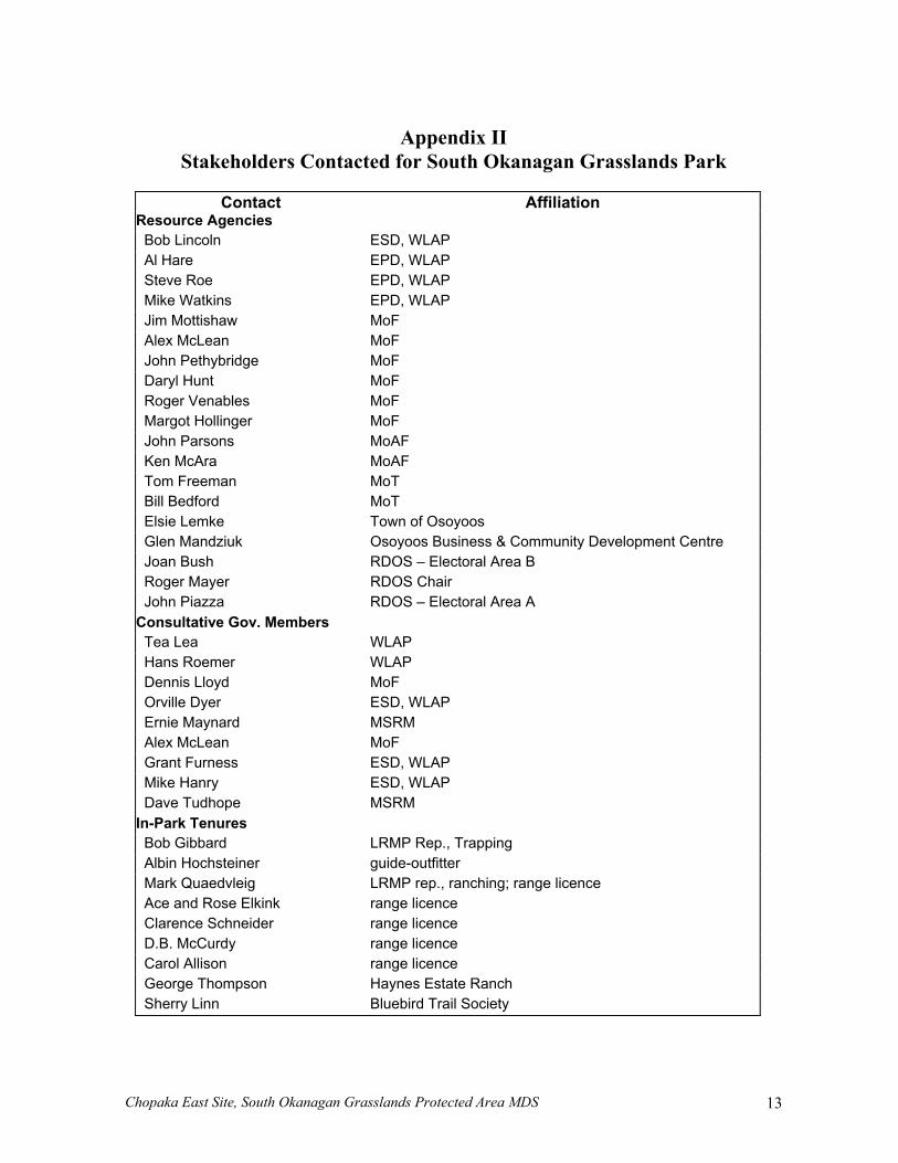
Appendix II
Stakeholders Contacted for South Okanagan Grasslands Park
Contact Affiliation Resource Agencies
Bob Lincoln ESD, WLAP Al Hare EPD, WLAP Steve Roe EPD, WLAP Mike Watkins EPD, WLAP Jim Mottishaw MoF Alex McLean MoF John Pethybridge MoF Daryl Hunt MoF Roger Venables MoF Margot Hollinger MoF John Parsons MoAF Ken McAra MoAF Tom Freeman MoT Bill Bedford MoT Elsie Lemke Town of Osoyoos Glen Mandziuk Osoyoos Business & Community Development Centre Joan Bush RDOS – Electoral Area B Roger Mayer RDOS Chair John Piazza RDOS – Electoral Area A
Consultative Gov. Members Tea Lea WLAP Hans Roemer WLAP Dennis Lloyd MoF Orville Dyer ESD, WLAP Ernie Maynard MSRM Alex McLean MoF Grant Furness ESD, WLAP Mike Hanry ESD, WLAP Dave Tudhope MSRM
In-Park Tenures Bob Gibbard LRMP Rep., Trapping Albin Hochsteiner guide-outfitter Mark Quaedvleig LRMP rep., ranching; range licence Ace and Rose Elkink range licence Clarence Schneider range licence D.B. McCurdy range licence Carol Allison range licence George Thompson Haynes Estate Ranch Sherry Linn Bluebird Trail Society
Chopaka East Site, South Okanagan Grasslands Protected Area MDS 14
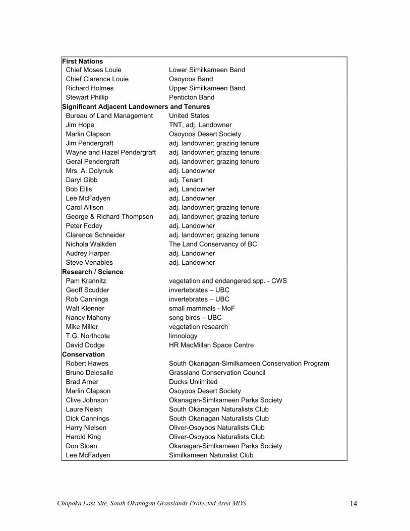
First Nations
Chief Moses Louie Lower Similkameen Band Chief Clarence Louie Osoyoos Band Richard Holmes Upper Similkameen Band Stewart Phillip Penticton Band
Significant Adjacent Landowners and Tenures Bureau of Land Management United States Jim Hope TNT, adj. Landowner Marlin Clapson Osoyoos Desert Society Jim Pendergraft adj. landowner; grazing tenure Wayne and Hazel Pendergraft adj. landowner; grazing tenure Geral Pendergraft adj. landowner; grazing tenure Mrs. A. Dolynuk adj. Landowner Daryl Gibb adj. Tenant Bob Ellis adj. Landowner Lee McFadyen adj. Landowner Carol Allison adj. landowner; grazing tenure George & Richard Thompson adj. landowner; grazing tenure Peter Fodey adj. Landowner Clarence Schneider adj. landowner; grazing tenure Nichola Walkden The Land Conservancy of BC Audrey Harper adj. Landowner Steve Venables adj. Landowner
Research / Science Pam Krannitz vegetation and endangered spp. - CWS Geoff Scudder invertebrates – UBC Rob Cannings invertebrates – UBC Walt Klenner small mammals - MoF Nancy Mahony song birds – UBC Mike Miller vegetation research T.G. Northcote limnology David Dodge HR MacMillan Space Centre
Conservation Robert Hawes South Okanagan-Similkameen Conservation Program Bruno Delesalle Grassland Conservation Council Brad Arner Ducks Unlimited Marlin Clapson Osoyoos Desert Society Clive Johnson Okanagan-Simlkameen Parks Society Laure Neish South Okanagan Naturalists Club Dick Cannings South Okanagan Naturalists Club Harry Nielsen Oliver-Osoyoos Naturalists Club Harold King Oliver-Osoyoos Naturalists Club Don Sloan Okanagan-Simlkameen Parks Society Lee McFadyen Similkameen Naturalist Club
Chopaka East Site, South Okanagan Grasslands Protected Area MDS 15
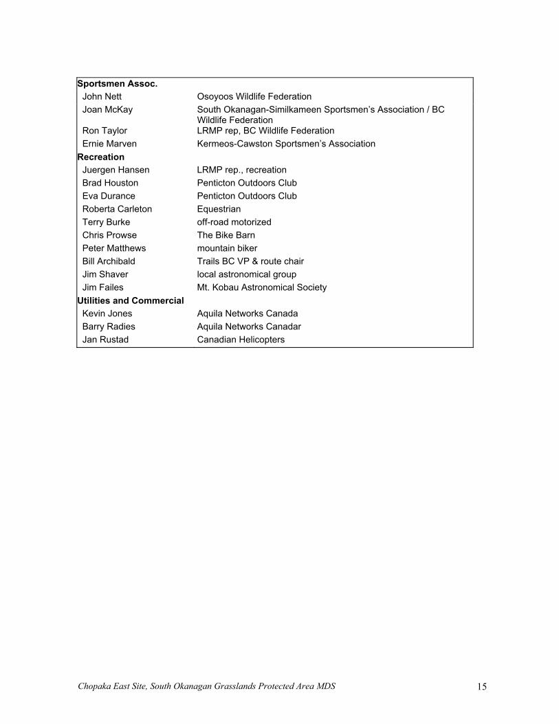
Sportsmen Assoc.
John Nett Osoyoos Wildlife Federation Joan McKay South Okanagan-Similkameen Sportsmen’s Association / BC
Wildlife Federation Ron Taylor LRMP rep, BC Wildlife Federation Ernie Marven Kermeos-Cawston Sportsmen’s Association
Recreation Juergen Hansen LRMP rep., recreation Brad Houston Penticton Outdoors Club Eva Durance Penticton Outdoors Club Roberta Carleton Equestrian Terry Burke off-road motorized Chris Prowse The Bike Barn Peter Matthews mountain biker Bill Archibald Trails BC VP & route chair Jim Shaver local astronomical group Jim Failes Mt. Kobau Astronomical Society
Utilities and Commercial Kevin Jones Aquila Networks Canada Barry Radies Aquila Networks Canadar Jan Rustad Canadian Helicopters
Chopaka East Site, South Okanagan Grasslands Protected Area MDS 16
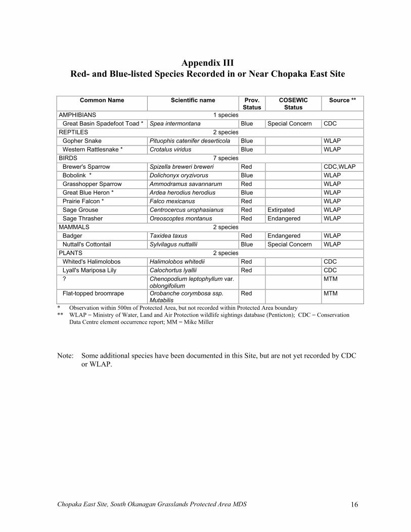
Appendix III
Red- and Blue-listed Species Recorded in or Near Chopaka East Site
Common Name Scientific name Prov. Status
COSEWIC Status
Source **
AMPHIBIANS 1 species Great Basin Spadefoot Toad * Spea intermontana Blue Special Concern CDC
REPTILES 2 species Gopher Snake Pituophis catenifer deserticola Blue WLAP Western Rattlesnake * Crotalus viridus Blue WLAP
BIRDS 7 species Brewer's Sparrow Spizella breweri breweri Red CDC,WLAP Bobolink * Dolichonyx oryzivorus Blue WLAP Grasshopper Sparrow Ammodramus savannarum Red WLAP Great Blue Heron * Ardea herodius herodius Blue WLAP Prairie Falcon * Falco mexicanus Red WLAP Sage Grouse Centrocercus urophasianus Red Extirpated WLAP Sage Thrasher Oreoscoptes montanus Red Endangered WLAP
MAMMALS 2 species Badger Taxidea taxus Red Endangered WLAP Nuttall's Cottontail Sylvilagus nuttallii Blue Special Concern WLAP
PLANTS 2 species Whited's Halimolobos Halimolobos whitedii Red CDC Lyall's Mariposa Lily Calochortus lyallii Red CDC ? Chenopodium leptophyllum var.
oblongifolium MTM
Flat-topped broomrape Orobanche corymbosa ssp. Mutabilis
Red MTM
* Observation within 500m of Protected Area, but not recorded within Protected Area boundary ** WLAP = Ministry of Water, Land and Air Protection wildlife sightings database (Penticton); CDC = Conservation
Data Centre element occurrence report; MM = Mike Miller Note: Some additional species have been documented in this Site, but are not yet recorded by CDC
or WLAP.
Chopaka East Site, South Okanagan Grasslands Protected Area MDS 17
Important Ecological Areas and Red/Blue Listed Species Observations – Chopaka East Site
Chopaka East Site, South Okanagan Grasslands Protected Area MDS 18
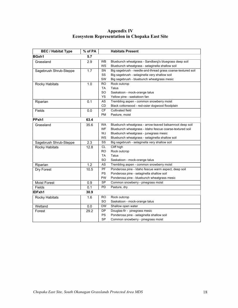
Appendix IV Ecosystem Representation in Chopaka East Site
BEC / Habitat Type % of PA Habitats Present BGxh1 5.7
Grassland 2.9 WB Bluebunch wheatgrass - Sandberg's bluegrass deep soil WS Bluebunch wheatgrass - selaginella shallow soil Sagebrush Shrub-Steppe 1.7 SN Big sagebrush - needle-and-thread grass coarse-textured soil SS Big sagebrush - selaginella very shallow soil SW Big sagebrush - bluebunch wheatgrass mesic Rocky Habitats 1.0 RO Rock outcrop TA Talus SO Saskatoon - mock-orange talus YS Yellow pine - saskatoon fan Riparian 0.1 AS Trembling aspen - common snowberry moist CD Black cottonwood - red-osier dogwood floodplain Fields 0.0 CF Cultivated field PM Pasture, moist
PPxh1 63.4
Grassland 35.6 WA Bluebunch wheatgrass - arrow-leaved balsamroot deep soil WF Bluebunch wheatgrass - Idaho fescue coarse-textured soil WJ Bluebunch wheatgrass - junegrass mesic WS Bluebunch wheatgrass - selaginella shallow soil Sagebrush Shrub-Steppe 2.3 SS Big sagebrush - selaginella very shallow soil Rocky Habitats 12.8 CL Cliff high RO Rock outcrop TA Talus SO Saskatoon - mock-orange talus Riparian 1.2 AS Trembling aspen - common snowberry moist Dry Forest 10.5 PF Ponderosa pine - Idaho fescue warm aspect, deep soil PS Ponderosa pine - selaginella shallow soil PW Ponderosa pine - bluebunch wheatgrass mesic Moist Forest 0.9 SP Common snowberry - pinegrass moist Fields 0.1 PD Pasture, dry
IDFxh1 30.9
Rocky Habitats 1.6 RO Rock outcrop SO Saskatoon - mock-orange talus Wetland 0.0 OW Shallow open water Forest 29.2 DP Douglas-fir - pinegrass mesic PS Ponderosa pine - selaginella shallow soil SP Common snowberry - pinegrass moist

Chopaka East Site, South Okanagan Grasslands Protected Area MDS 19
Ecosystem Representation – Chopaka East Site