Embed Size (px)
Citation preview
Skeena District
MANAGEMENT DIRECTION
STATEMENT
September 2000
for Bulkley JunctionProvincial Park Ministry of Environment
Lands and ParksBC Parks Division
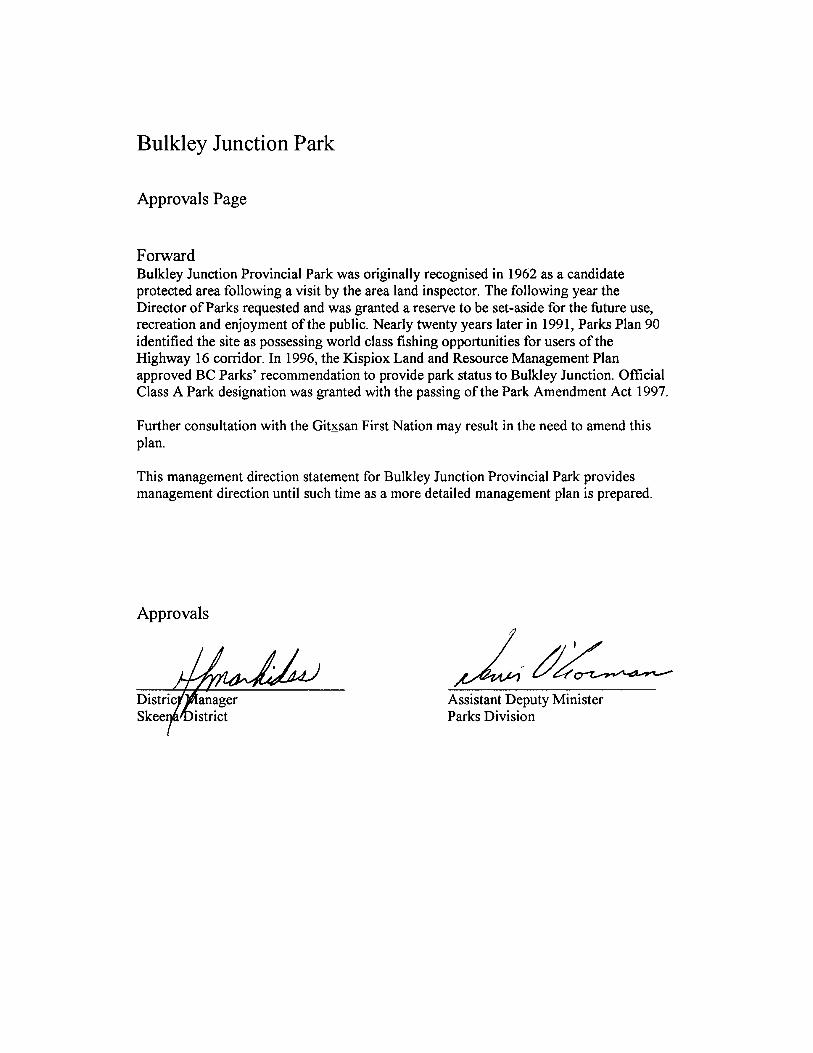

This management direction statement was developed through direction received fromthe Kispiox Land and Resource Management Plan.
i
Table of Contents
Bulkley Junction Park
Introduction.........................................................................................................................1Purpose of the MDS..............................................................................................................1Setting and Context................................................................................................................1
Protected Area Attributes ..................................................................................................1Conservation.........................................................................................................................1Recreation and Tourism.........................................................................................................1Cultural Heritage....................................................................................................................4Significance in the Protected Areas System.............................................................................4
Land Uses, Tenures and Interests .....................................................................................4Access ..................................................................................................................................4Existing Tenures.....................................................................................................................4Existing Land Use Activities and Facilities...............................................................................4Adjacent Patterns of Land Use...............................................................................................5First Nations Interests ............................................................................................................5Other Agency Interests ..........................................................................................................5Private and Public Stakeholder Interests .................................................................................6
Role of Bulkley Junction Park ...........................................................................................6
Management Commitments and Issues ............................................................................6Direction from Previous Planning............................................................................................6Management Issues................................................................................................................7
Management Strategy........................................................................................................8Consultation and Future Planning............................................................................................9Preliminary Zoning .................................................................................................................9
FiguresRegional Location Map .........................................................................................................2Park Map..............................................................................................................................3
Appendix I – Table of Acceptable Activities, Uses and Facilities..................................10

ii
This page left blank on purpose
1
Introduction
PurposeThis management direction statement (MDS) provides management for Bulkley Junction Park.It identifies key strategies that will be ranked according to priority and completed as fundingpermits. Implementation of the MDS strategies will be dependent on available funding andagency priorities. All development associated with these strategies is subject to BC ParksImpact Assessment Policy.
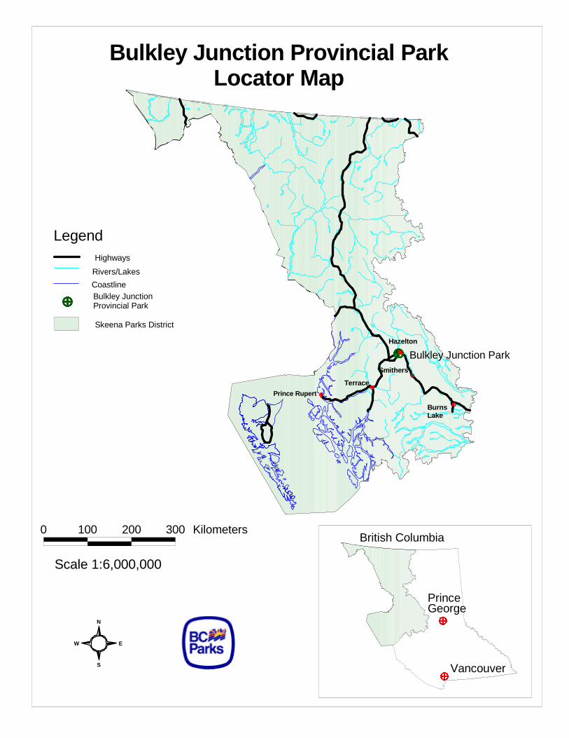
Setting and ContextBulkley Junction Provincial Park is located directly across from Hazelton and the confluence ofthe Skeena and Bulkley Rivers. The 133 ha park has regionally significant conservation andrecreation values. A glaciofluvial terrace and adjacent floodplain represent a small, butimportant, sample of the Nass Basin Ecosection. As well, Bulkley Junction helps fulfil a BCParks Goal of facilitating tourism access to the world-class fishery adjacent to Highway 16.
Protected Area Attributes
Conservation• Nass Basin Ecosection; ICHmc3 (interior cedar hemlock)• riparian zone on the Skeena River’s alluvial floodplain• gently sloping glaciofluvial terrace• possible freshwater spring along the park’s northeast bank• moose and bear habitat along the river bank and the terrace
Recreation and TourismThe scenic views and excellent angling opportunities in the Skeena River have led to local dayuse of the shoreline area. The park is used primarily by local residents; however, the travel routeof a Regional District publication titled the “Hands of History Driving Tour” passes through thepark. This brochure describes First Nations history in the Hazeltons and along the KitwangaBack Road and has a stop 4-km to the west of the park at a sign called Temlahan.Features include:• 2.5 km of shoreline along the Skeena River• recreational angling• scenic views of Hagwilget Mountain, the Junction of the Bulkley and the Skeena Rivers, a
railway trestle bridge, and steep eroded river banks• recognised by Parks Plan 90 as a logical location to provide angling opportunities for users
of the Highway 16 corridor• First Nations fishery at the south end of the park• potential river raft/boat camping location
S
N
EW
Bulkley Junction Provincial ParkLocator Map
Highways
Rivers/Lakes
CoastlineBulkley JunctionProvincial Park
Skeena Parks District
Prince RupertTerrace
Legend
Scale 1:6,000,000
0 100 200 300 Kilometers
Hazelton
Bulkley Junction Park
British Columbia
PrinceGeorge
Vancouver
BurnsLake
Smithers
0 500 1000 1500 Meters
Bulkley JunctionProvincial Park
Bul
kley
Riv
er
To Hazelton12 km.
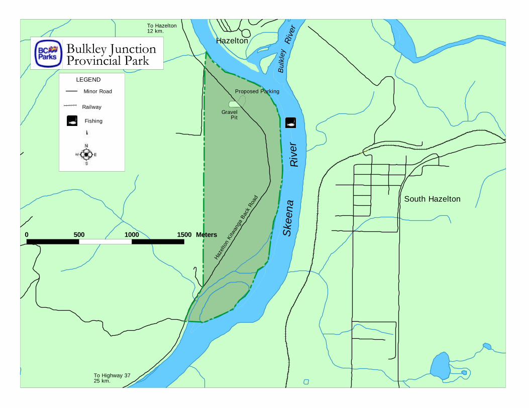
GravelPit
Haze
lton
Kitw
anga
Bac
k Ro
ad
Ske
ena
Riv
er
Hazelton
South Hazelton
Proposed Parking
LEGEND
Fishing
Railway
To Highway 3725 km.
Minor Road
4
Cultural Heritage• asserted Gitxsan Traditional Territory - identified Gitxsan Chief is Luutkudziiwus• Temlaham signpost 4 km to the west describes the terrace as a place of origin for many of
the areas’ First Nations• an old cart trail and possibly a grease trail may have crossed through this area• other attributes unknown
Significance in the Protected Areas System• provides a 2.5 km long forested buffer zone between the Skeena River and private farmland• provides angling access to the Skeena River for local residents and for Highway 16
Corridor visitors• provides an important recreational destination along an increasingly developed and
inaccessible shoreline• protects important riparian zone habitat along the shoreline of the Skeena River• represents a small area of an underrepresented biogeoclimatic zone, Interior Cedar
Hemlock (ICHmc3), in the Nass Basin Ecosection
Land Uses, Tenures and Interests
AccessThe unpaved Kitwanga Back Road, km 7-9, bisects the park. The back road is accessed fromthe Kispiox Road at a point just north of the Skeena River Bridge. No formal trails or parkingareas exist within the park. Currently, visitors park on the side of the road and find their ownroute to the shoreline.
Existing Tenures• Hazelton-Kitwanga Back Road No. 113 is excluded from the park• Ministry of Transportation and Highways Quarrying Reserve No. 84650 as shown on lands
file 6401981 is excluded from the park• UREP Reserve 0245022 is entirely within the park and is superseded by the Park
Amendment Act• No Staking Reserve BC Regulation 161/96 is superseded by the Park Amendment Act• Guide Outfitting License 630G001• Trap Line 0630T003• License 633000 file 0331911 - Distribution line right of way, held in favour of BC Hydro,
through portions of Block B District Lots 147 and 148• Dominion Telegraph Line Right of Way may impact upon the park
Existing Land Use Activities and Facilities• an old gravel pit lies within the park across from the active gravel pit• in the centre of the old gravel pit a McElhanney pin #9501 marks the location of a makeshift
helicopter landing pad• overgrown remnants of an old cart road exist
5
• an old cart trail leads halfway down the hillside at the north end of the park until it suddenlydrops 13 m straight down due to erosion from the Skeena River
• an old narrow trail, 200 m south of the end of the cart road, provides access to the northernportion of the park
• unnamed island at the south end is used for First Nations food fishery• possible trespass situation along the western boundary including farm access roads, farm
land, farm fences, old building and outhouse (at the south southwest boundary)
Adjacent Patterns of Land UseThe area surrounding the park is zoned as agricultural land reserve and is privately held.Clearing of this adjacent farm land will leave the park’s valuable riparian zone and the forestedupland section fragmented from nearby wilderness and not part of a co-ordinated EcosystemNetwork.• a non-status road leads onto the floodplain, from the Kitwanga Back Road, and provides
vehicle access to the southern island• Ministry of Transportation and Highways Road, Survey No. 5149 - Plan No. 8747, abuts
the western boundary of the southernmost portion of the park and is known as WayneRoad
• privately held farmland lies adjacent to the western boundary of the park• a small private sawmill is situated adjacent to the southwest boundary of the park• the Skeena River forms most of the north, south and east boundaries of the park• Old Town Hazelton lies across the river at the north end of the park• across the river to the northeast lies the Bulkley River Delta, locally known as Anderson
Flats, at its confluence with the Skeena River• South Hazelton is situated across the river to the east of the park
First Nations Interests• asserted traditional territory of Gitxsan people• identified by the Gitxsan Treaty Office as Luutkudziiwus House• First Nation’s net fishing is conducted from the southern unnamed island in the park• a grease trail may have crossed through the park area• consultation by BC Parks ongoing; First Nations aboriginal rights will be honoured and
protected subject to safety and conservation concerns
Other Agency Interests• BC Environment administers trapping and guide-outfitting tenures and has an interest in
wildlife habitat and management in the area• BC Environment and Department of Fisheries and Oceans manage the Skeena fisheries
resource• Regional District of Kitimat-Stikine identifies the park and surrounding area as Agricultural
Land Reserve (ALR Plan was filed after area was reserved for BC Parks)
6
Private and Public Stakeholder Interests• recreational users: anglers, recreational boaters, Hazelton Cross Country Ski Club• local residents: Hazelton and Kispiox communities, Kispiox Valley Community Association• Hagwilget Village Council, Glen Vowell Indian Band, Kispiox Indian Band, Regional
District of Kitimat - Stikine• Kispiox Land and Resource Management Plan Table Members• trapper and guide outfitter, Northwest Guides and Outfitters Association• farmers with land bordering the park• Northern British Columbia Tourism Association• Steelhead Society of BC, Sport Fish Advisory Board• Local Schools
Role of Bulkley Junction ParkBulkley Junction Park serves both conservation and recreation roles. The park's chiefconservation role focuses on protecting special features including important riparian zone habitatalong the shoreline of the Skeena River and a small area of an underrepresented biogeoclimaticzone in the protected areas system, the Interior Cedar Hemlock (ICHmc3), in the Nass BasinEcosection.
The park's recreation role is important as it provides angling access to the Skeena River forlocal residents and for Highway 16 Corridor visitors and serves as a preferred recreationaldestination along an increasingly developed and inaccessible shoreline.
Management Commitments and Issues
Direction from Previous PlanningThe Kispiox Land and Resource Management Plan (LRMP) approved park designation as partof their final report in 1996. The area was one of a few special features protected areasidentified to the table after consensus recommendation was reached, and therefore littledirection has been provided. The LRMP approved and recognised the site as an importantrecreational fishing and day use area. The LRMP is consistent with earlier Park’s Plan for the90’s direction which identified Bulkley Junction as a strategic location offering world-classfishing opportunities for travelers using the Highway 16 corridor. Furthermore, the Protectedareas strategy recognised the Skeena River as an area providing “outstanding fishingopportunities in a wilderness setting” and this park provides such an opportunity.
7
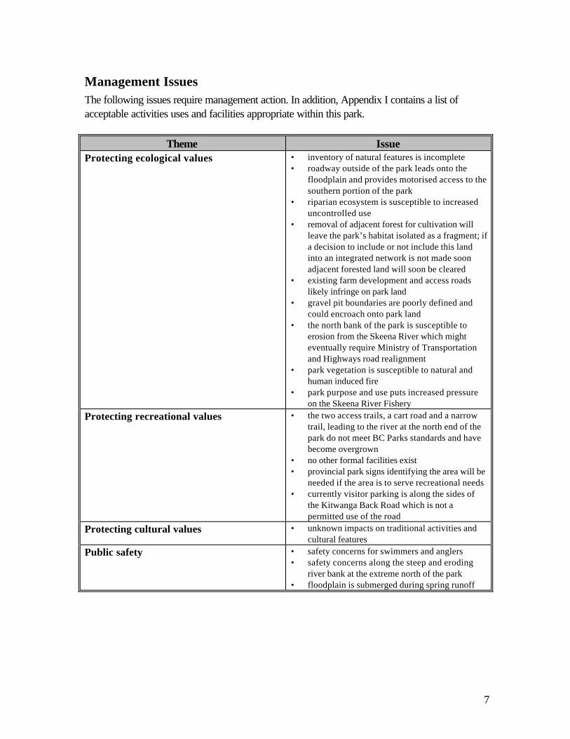
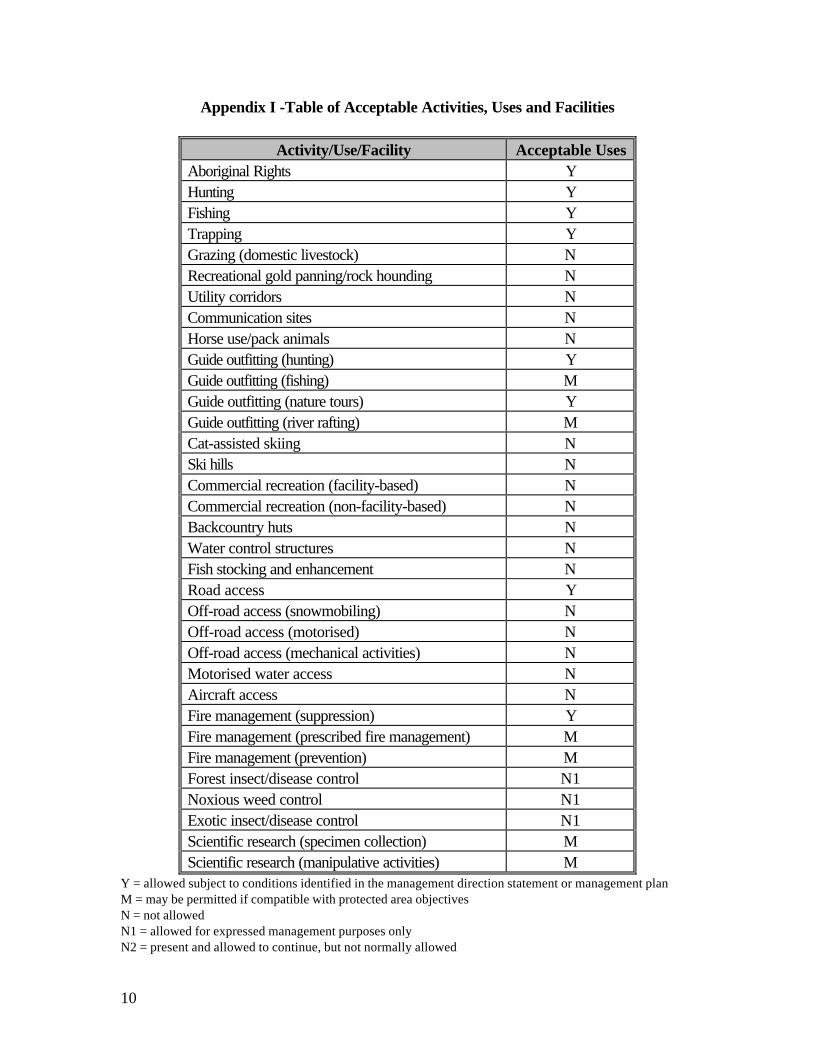
Management IssuesThe following issues require management action. In addition, Appendix I contains a list ofacceptable activities uses and facilities appropriate within this park.
Theme IssueProtecting ecological values • inventory of natural features is incomplete
• roadway outside of the park leads onto thefloodplain and provides motorised access to thesouthern portion of the park
• riparian ecosystem is susceptible to increaseduncontrolled use
• removal of adjacent forest for cultivation willleave the park’s habitat isolated as a fragment; ifa decision to include or not include this landinto an integrated network is not made soonadjacent forested land will soon be cleared
• existing farm development and access roadslikely infringe on park land
• gravel pit boundaries are poorly defined andcould encroach onto park land
• the north bank of the park is susceptible toerosion from the Skeena River which mighteventually require Ministry of Transportationand Highways road realignment
• park vegetation is susceptible to natural andhuman induced fire
• park purpose and use puts increased pressureon the Skeena River Fishery
Protecting recreational values • the two access trails, a cart road and a narrowtrail, leading to the river at the north end of thepark do not meet BC Parks standards and havebecome overgrown
• no other formal facilities exist• provincial park signs identifying the area will be
needed if the area is to serve recreational needs• currently visitor parking is along the sides of
the Kitwanga Back Road which is not apermitted use of the road
Protecting cultural values • unknown impacts on traditional activities andcultural features
Public safety • safety concerns for swimmers and anglers• safety concerns along the steep and eroding
river bank at the extreme north of the park• floodplain is submerged during spring runoff
8
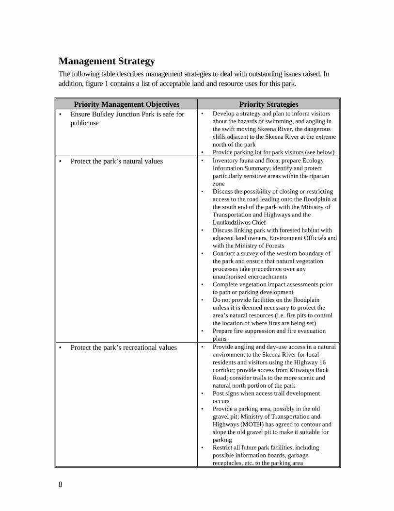
Management StrategyThe following table describes management strategies to deal with outstanding issues raised. Inaddition, figure 1 contains a list of acceptable land and resource uses for this park.
Priority Management Objectives Priority Strategies• Ensure Bulkley Junction Park is safe for
public use• Develop a strategy and plan to inform visitors
about the hazards of swimming, and angling inthe swift moving Skeena River, the dangerouscliffs adjacent to the Skeena River at the extremenorth of the park
• Provide parking lot for park visitors (see below)• Protect the park’s natural values • Inventory fauna and flora; prepare Ecology
Information Summary; identify and protectparticularly sensitive areas within the riparianzone
• Discuss the possibility of closing or restrictingaccess to the road leading onto the floodplain atthe south end of the park with the Ministry ofTransportation and Highways and theLuutkudziiwus Chief
• Discuss linking park with forested habitat withadjacent land owners, Environment Officials andwith the Ministry of Forests
• Conduct a survey of the western boundary ofthe park and ensure that natural vegetationprocesses take precedence over anyunauthorised encroachments
• Complete vegetation impact assessments priorto path or parking development
• Do not provide facilities on the floodplainunless it is deemed necessary to protect thearea’s natural resources (i.e. fire pits to controlthe location of where fires are being set)
• Prepare fire suppression and fire evacuationplans
• Protect the park’s recreational values • Provide angling and day-use access in a naturalenvironment to the Skeena River for localresidents and visitors using the Highway 16corridor; provide access from Kitwanga BackRoad; consider trails to the more scenic andnatural north portion of the park
• Post signs when access trail developmentoccurs
• Provide a parking area, possibly in the oldgravel pit; Ministry of Transportation andHighways (MOTH) has agreed to contour andslope the old gravel pit to make it suitable forparking
• Restrict all future park facilities, includingpossible information boards, garbagereceptacles, etc. to the parking area
9
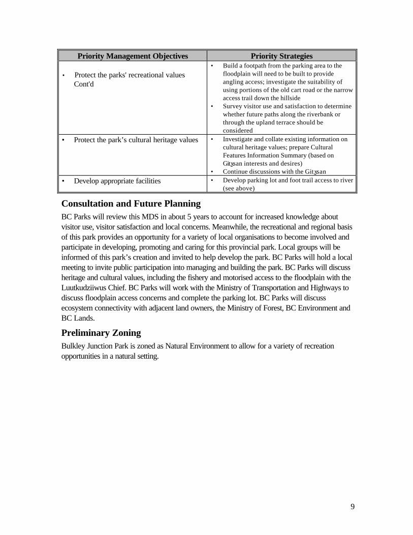
Priority Management Objectives Priority Strategies
• Protect the parks' recreational valuesCont'd
• Build a footpath from the parking area to thefloodplain will need to be built to provideangling access; investigate the suitability ofusing portions of the old cart road or the narrowaccess trail down the hillside
• Survey visitor use and satisfaction to determinewhether future paths along the riverbank orthrough the upland terrace should beconsidered
• Protect the park’s cultural heritage values • Investigate and collate existing information oncultural heritage values; prepare CulturalFeatures Information Summary (based onGitxsan interests and desires)
• Continue discussions with the Gitxsan• Develop appropriate facilities • Develop parking lot and foot trail access to river
(see above)
Consultation and Future PlanningBC Parks will review this MDS in about 5 years to account for increased knowledge aboutvisitor use, visitor satisfaction and local concerns. Meanwhile, the recreational and regional basisof this park provides an opportunity for a variety of local organisations to become involved andparticipate in developing, promoting and caring for this provincial park. Local groups will beinformed of this park’s creation and invited to help develop the park. BC Parks will hold a localmeeting to invite public participation into managing and building the park. BC Parks will discussheritage and cultural values, including the fishery and motorised access to the floodplain with theLuutkudziiwus Chief. BC Parks will work with the Ministry of Transportation and Highways todiscuss floodplain access concerns and complete the parking lot. BC Parks will discussecosystem connectivity with adjacent land owners, the Ministry of Forest, BC Environment andBC Lands.
Preliminary ZoningBulkley Junction Park is zoned as Natural Environment to allow for a variety of recreationopportunities in a natural setting.
10
Appendix I -Table of Acceptable Activities, Uses and Facilities
Activity/Use/Facility Acceptable UsesAboriginal Rights YHunting YFishing YTrapping YGrazing (domestic livestock) NRecreational gold panning/rock hounding NUtility corridors NCommunication sites NHorse use/pack animals NGuide outfitting (hunting) YGuide outfitting (fishing) MGuide outfitting (nature tours) YGuide outfitting (river rafting) MCat-assisted skiing NSki hills NCommercial recreation (facility-based) NCommercial recreation (non-facility-based) NBackcountry huts NWater control structures NFish stocking and enhancement NRoad access YOff-road access (snowmobiling) NOff-road access (motorised) NOff-road access (mechanical activities) NMotorised water access NAircraft access NFire management (suppression) YFire management (prescribed fire management) MFire management (prevention) MForest insect/disease control N1Noxious weed control N1Exotic insect/disease control N1Scientific research (specimen collection) MScientific research (manipulative activities) M
Y = allowed subject to conditions identified in the management direction statement or management planM = may be permitted if compatible with protected area objectivesN = not allowedN1 = allowed for expressed management purposes onlyN2 = present and allowed to continue, but not normally allowed