Embed Size (px)
Citation preview
1
MALOMA RIV ER DREDGING PROJECT
EXECUTIVE SUMMARY FOR PUBLICATION
In accordance with Section 12 of DAO 2017 – 15
1. PROJECT DESCRIPTION
Project Type Dredging, Environmental Mitigation; Disaster Risk Reduction; Climate
Change Adaptation
Project Components 1. Buffer zone (river channel) between the river banks and a pilot channel, 1/3 or river width, both sides, therefore totaling 2/3 of river width
2. Buffer zone 50m from Maloma River and Lower Maloma Steel Bridge, for the full river width, wherein to install ground sill geo tube, -2m from lahar surface
3. Armor rock shield around each bridge column, starting from ground surface to the level allowed for depth of extraction;
4. Pilot channel at the middle 1/3 of the river width, in this case constant 40m wide, 2 meters deep and 2,300 meters long from 363 meters upstream of Maloma River to 350m from shoreline;
5. Buffer zone 200m from shoreline to dredging basin 6. Transport of dredged materials 7. Cost recovery through sale of dredged materials, subject to
appropriate government regulations
Project Size 1. Buffer Zone total area 48.35 2. Pilot channel dredging area 40m x 2,000m x2m 3. Dredging basin 150m x 150m by 4m deep (2.25) 4. Continuous removal of sediments from designated pilot channel and
dredging basin as these are refilled by natural processes, until stable riverbed elevation is reached at 8meters below (current) ground surface at lower Maloma River, measured every November of each year
5. Estimated lahar volume to be extracted is 12,120,375.00 m3 .
Process Technology 1. Embedment of 2m diameter geotube protection / ground sill 50m
from bridges, -2m depth;
2. Protection of armor rock to surround bridge columns, starting from
the depth of allowed dredging to lahar surface
3. Extraction to create 40m wide pilot channel, 2 meters deep 2,000m
long;
4. Embedment of geotube retaining walls of dredging basin at river
mouth by -2m below surface, to facilitate sediment inflow under
normal rain condition
5. River bank protection by >40m easement and natural slope repose
6. Fair weather extraction by amphibious dredger
7. Haul out/ transport by water mode (barge)
8. Replenishment of dredging areas by natural sediment transport
9. Marine ecosystem protection by 200m land barrier between
dredging basin and shoreline
2
Resource Utilization 42.81 tons diesel to dredge 12.120 million m3 lahar
Not a water intensive undertaking thus no water use competition
Criteria for selecting Project Alternative
The option selected by the Project creates a rallying point for the replication of similar extraction
strategy for local sand and gravel permit holders to cooperate toward effecting flood reduction,
river re-training and protecting government infrastructures. The option is defined as :
1. Having lesser social conflict and therefore may yield a good demonstration model
2. Central river channel dredging, keeping equidistance from both banks
3. Pilot dredging channel is only 30% of river width
4. Pilot dredging depth is an initial trial depth to observe actual sediment transport behavior
and pattern; observe scouring forces on bridge columns
5. Bridge ground sill or mattress protects against massive sediment movement underneath
bridge to protect bridge stability, while allowing sediment flow at uppermost .5 meters of
lahar surface
6. Bridge column protection made of piled armour rock starting from ground level to the
depth allowed for dredging. The armor rock will adjust to ground surface elevation at
lowering of lahar level
This option has the following advantages:
1. Preserves bridge stability
2. Encourages increased natural sediment transport processes, to shorten period to effect
flood reduction services
3. Maloma River has fewer sand and gravel permit holders, entailing lesser social conflict in
operation, easier demonstration project
4. Uses available natural materials to liquidate project costs to deliver flood control service
instead of incurring government expenditures to deliver the same service
5. Sustainable approach to flood reduction compared to engineered solutions which will
eventually be overtaken by continuing downflow of lahar from upper reaches of Mt.
Pinatubo
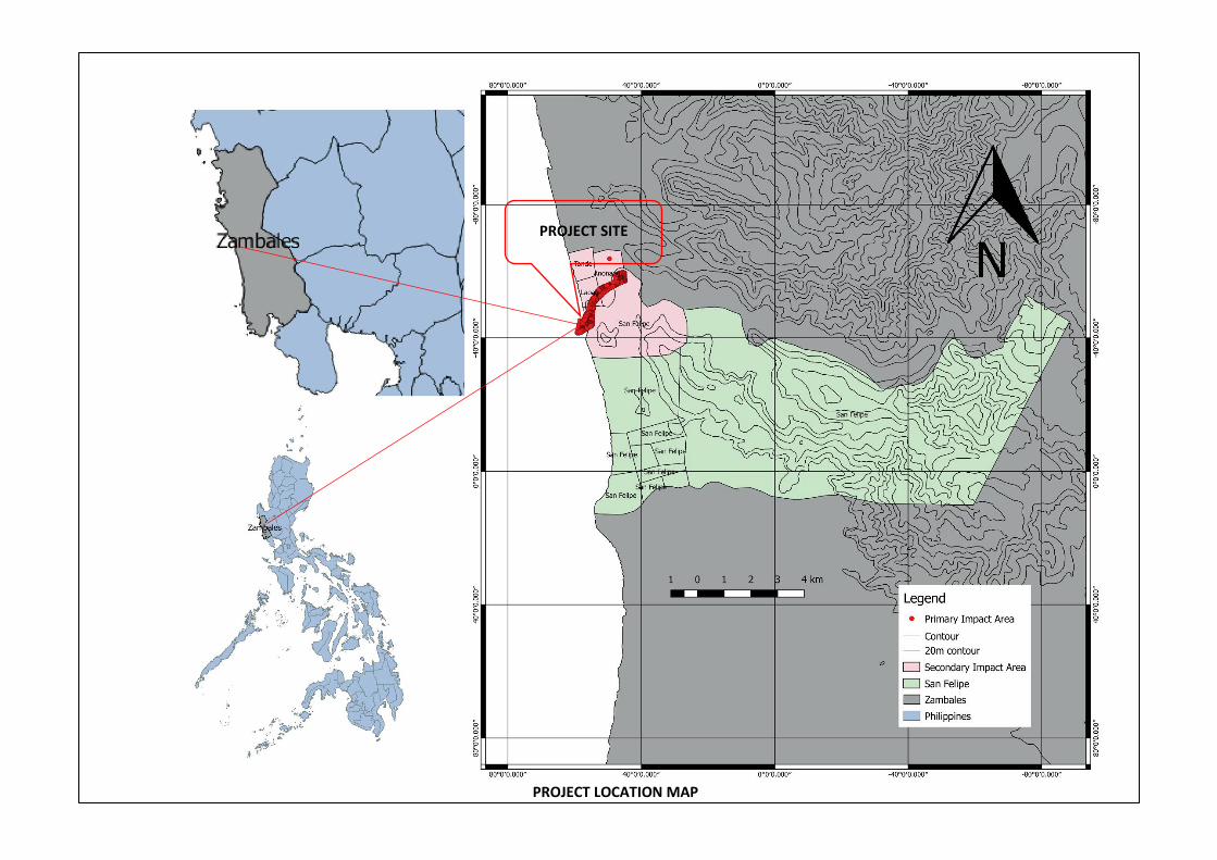
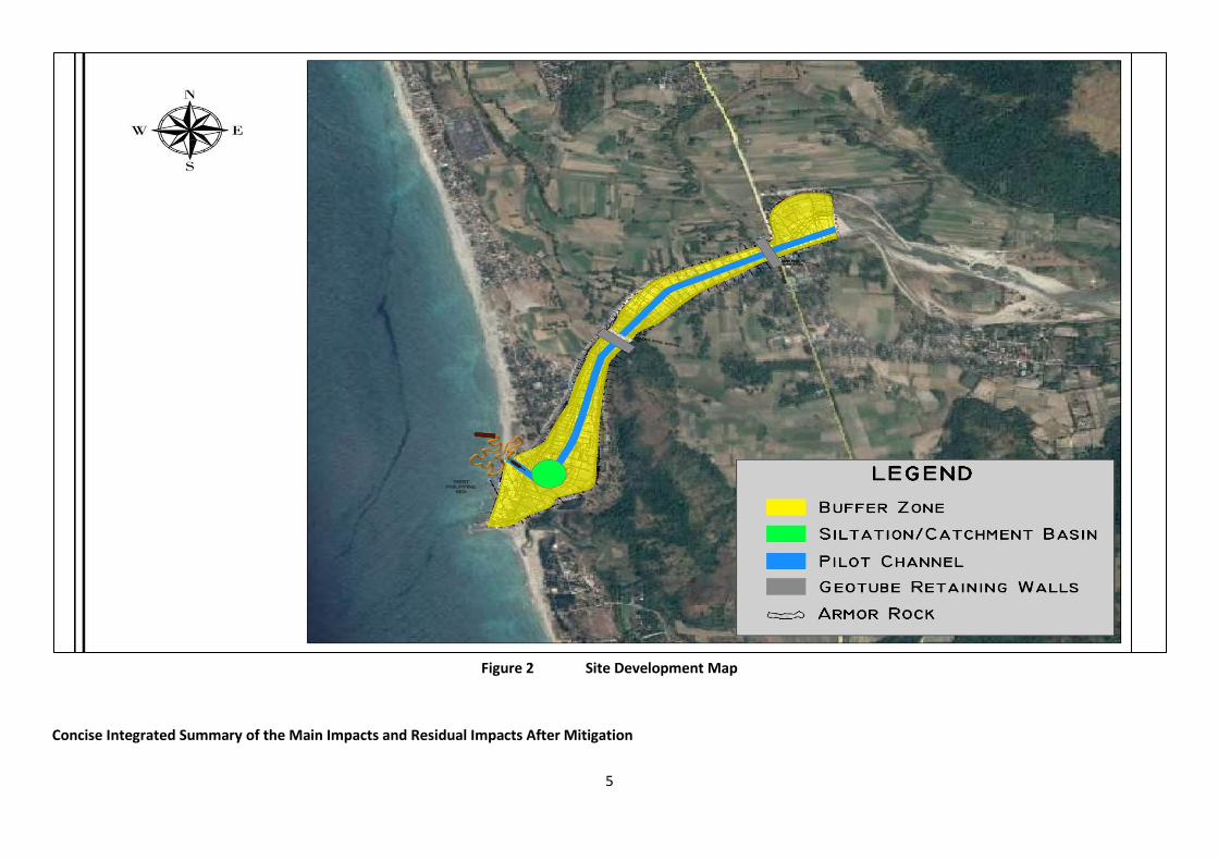
Proposed location map is attached in Figures 1 and Figure 2 is the site development lay-out.
The Primary Project Impact Area is Barangay Maloma. The secondary impact areas are Barangays
flanking the Lower Maloma River namely Sitio South and North Laoag, Tondo and Anonang who
will be among the first to experience reduction in flooding. The regional impact area are upstream
barangays flanking Upper Maloma River.
Project Proponent and Incorporators are attached in Annex A.
3
Public Consultation Meeting Venue
Coordinates: 15.05430° 120.06818° or 15°03'15.5"N 120°04'05.4"E
Elevation: 1 m
Link: View in Google Maps https://goo.gl/maps/7AdFFcKqy7F2 (pls copy and paste this in your
google map to search direction, thank you)
Project Implementation Timeframe : Starting 3rd quarter 2018
4
PROJECT SITE
PROJECT LOCATION MAP
5
Figure 2 Site Development Map
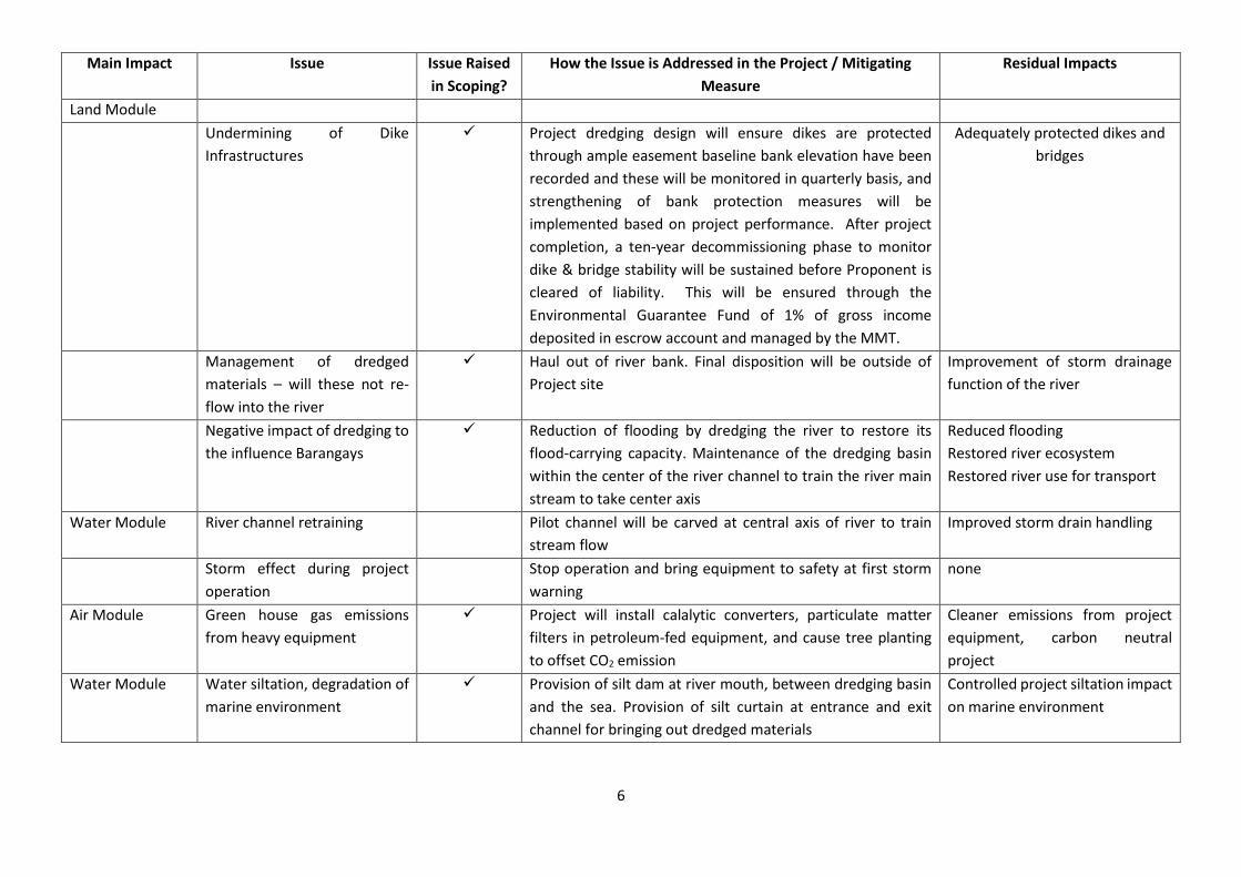
Concise Integrated Summary of the Main Impacts and Residual Impacts After Mitigation
6
Main Impact Issue Issue Raised
in Scoping?
How the Issue is Addressed in the Project / Mitigating
Measure
Residual Impacts
Land Module
Undermining of Dike
Infrastructures
Project dredging design will ensure dikes are protected
through ample easement baseline bank elevation have been
recorded and these will be monitored in quarterly basis, and
strengthening of bank protection measures will be
implemented based on project performance. After project
completion, a ten-year decommissioning phase to monitor
dike & bridge stability will be sustained before Proponent is
cleared of liability. This will be ensured through the
Environmental Guarantee Fund of 1% of gross income
deposited in escrow account and managed by the MMT.
Adequately protected dikes and
bridges
Management of dredged
materials – will these not re-
flow into the river
Haul out of river bank. Final disposition will be outside of
Project site
Improvement of storm drainage
function of the river
Negative impact of dredging to
the influence Barangays
Reduction of flooding by dredging the river to restore its
flood-carrying capacity. Maintenance of the dredging basin
within the center of the river channel to train the river main
stream to take center axis
Reduced flooding
Restored river ecosystem
Restored river use for transport
Water Module River channel retraining Pilot channel will be carved at central axis of river to train
stream flow
Improved storm drain handling
Storm effect during project
operation
Stop operation and bring equipment to safety at first storm
warning
none
Air Module Green house gas emissions
from heavy equipment
Project will install calalytic converters, particulate matter
filters in petroleum-fed equipment, and cause tree planting
to offset CO2 emission
Cleaner emissions from project
equipment, carbon neutral
project
Water Module Water siltation, degradation of
marine environment
Provision of silt dam at river mouth, between dredging basin
and the sea. Provision of silt curtain at entrance and exit
channel for bringing out dredged materials
Controlled project siltation impact
on marine environment
7
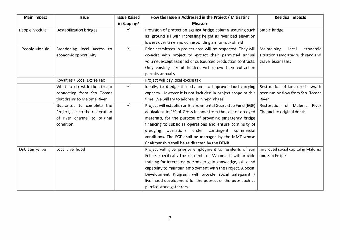
Main Impact Issue Issue Raised
in Scoping?
How the Issue is Addressed in the Project / Mitigating
Measure
Residual Impacts
People Module Destabilization bridges
Provision of protection against bridge column scouring such
as ground sill with increasing height as river bed elevation
lowers over time and corresponding armor rock shield
Stable bridge
People Module Broadening local access to
economic opportunity
X Prior permittees in project area will be respected. They will
co-exist with project to extract their permitted annual
volume, except assigned or outsourced production contracts.
Only existing permit holders will renew their extraction
permits annually
Maintaining local economic
situation associated with sand and
gravel businesses
Royalties / Local Excise Tax Project will pay local excise tax
What to do with the stream
connecting from Sto Tomas
that drains to Maloma River
Ideally, to dredge that channel to improve flood carrying
capacity. However it is not included in project scope at this
time. We will try to address it in next Phase.
Restoration of land use in swath
over-run by flow from Sto. Tomas
River
Guarantee to complete the
Project, see to the restoration
of river channel to original
condition
Project will establish an Environmental Guarantee Fund (EGF)
equivalent to 1% of Gross Income from the sale of dredged
materials, for the purpose of providing emergency bridge
financing to subsidize operations and ensure continuity of
dredging operations under contingent commercial
conditions. The EGF shall be managed by the MMT whose
Chairmanship shall be as directed by the DENR.
Restoration of Maloma River
Channel to original depth
LGU San Felipe Local Livelihood Project will give priority employment to residents of San
Felipe, specifically the residents of Maloma. It will provide
training for interested persons to gain knowledge, skills and
capability to maintain employment with the Project. A Social
Development Program will provide social safeguard /
livelihood development for the poorest of the poor such as
pumice stone gatherers.
Improved social capital in Maloma
and San Felipe
8
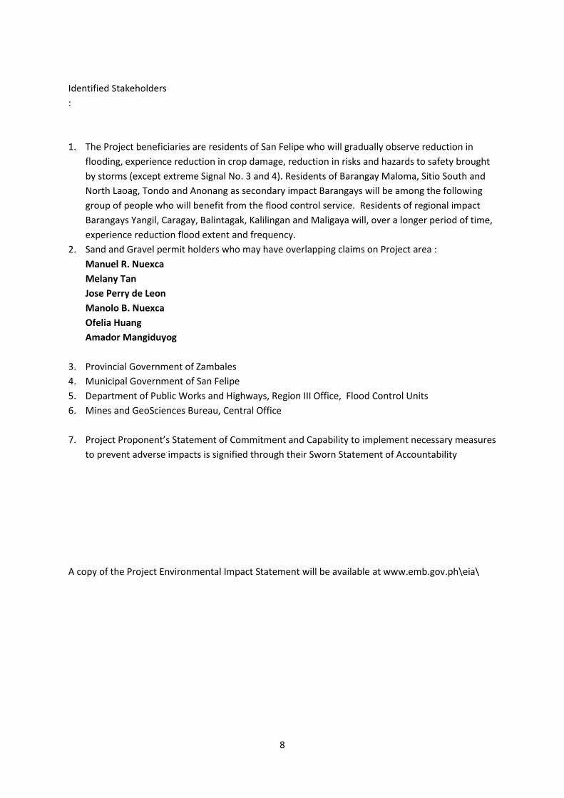
Identified Stakeholders
:
1. The Project beneficiaries are residents of San Felipe who will gradually observe reduction in
flooding, experience reduction in crop damage, reduction in risks and hazards to safety brought
by storms (except extreme Signal No. 3 and 4). Residents of Barangay Maloma, Sitio South and
North Laoag, Tondo and Anonang as secondary impact Barangays will be among the following
group of people who will benefit from the flood control service. Residents of regional impact
Barangays Yangil, Caragay, Balintagak, Kalilingan and Maligaya will, over a longer period of time,
experience reduction flood extent and frequency.
2. Sand and Gravel permit holders who may have overlapping claims on Project area :
Manuel R. Nuexca
Melany Tan
Jose Perry de Leon
Manolo B. Nuexca
Ofelia Huang
Amador Mangiduyog
3. Provincial Government of Zambales
4. Municipal Government of San Felipe
5. Department of Public Works and Highways, Region III Office, Flood Control Units
6. Mines and GeoSciences Bureau, Central Office
7. Project Proponent’s Statement of Commitment and Capability to implement necessary measures
to prevent adverse impacts is signified through their Sworn Statement of Accountability
A copy of the Project Environmental Impact Statement will be available at www.emb.gov.ph\eia\