Embed Size (px)
Citation preview
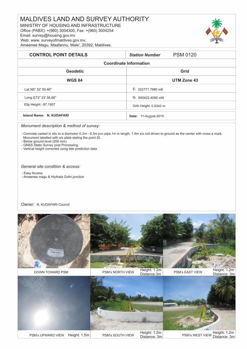
- Concrete casted in situ to a m pvc pipe,1m in length, 1.5m s/s rod driven to ground as the center with cross a mark.diameter 0.2m ‐ 0.3 Monument labelled with s/s plate stating the point ID. - Below ground level (200 mm) - GNSS Static Survey post Processing. - Vertical height corrected using tide prediction data
Coordinate Information
WGS 84
Station Number PSM 0120
Lat:
Ellp Height: -97.1957
Geodetic
Long:
Monument description & method of survey:
UTM Zone 43
E:
Orth Height:
Grid
N:
Owner:
General site condition & access:
CONTROL POINT DETAILS
DOWN TOWARD PSM
PSM’s UPWARD VIEW
PSM’s NORTH VIEW PSM’s EAST VIEW
PSM’s SOUTH VIEW PSM’s WEST VIEW
Date: 11-August-2015Island Name: N. KUDAFARI
MINISTRY OF HOUSING AND INFRASTRUCTUREOffice (PABX): +(960) 3004300, Fax: +(960) 3004254Email: [email protected]: www. surveyofmaldives.gov.mv,Ameenee Magu, Maafannu, Male', 20392, Maldives.
MALDIVES LAND AND SURVEY AUTHORITY
- Easy Access- Ameenee magu & Hiythala Golhi junction
N. KUDAFARI Council
Height: 1.2mDistance:3m
Height: 1.2mDistance: 3m
Height: 1.2mDistance: 3m
Height: 1.2mDistance: 3mHeight: 1.5m
322771.7980 mE
650422.4090 mN
0.9342 m
N5° 52' 55.46"
E73° 23' 56.86"

SITE INFORMATION Station Number
LocalityStation Horizon Mask
Height above Marker that horizon
0
was mapped from _________ m
330
30
180150
210
90
60
120
270
240
300
Magnetic DeclinationDeclination applied to this figure?
Yes No
80 o
70 o
60 o
50 o
40 o
30 o
20 o
10 o
MN
03
TN
North
Sketched by: Scale: Not to scale Date:
Ameenee Magu, Maafannu, Male', 20392, Maldives,Maldives Land and Survey Authority ,MINISTRY OF HOUSING AND INFRASTRUCTURE,
Web: [email protected], www.surveyofmaldives.gov.mvOffice (PABX): +(960) 3004300, Fax: +(960) 3004254, Email:
1.5
Latheef 11-August-2015
P S M 0 1 2 0
Trees
Trees
Lamp
Mosque
PSM 0120
13.29 m
Ameenee magu
31.89 m
0.84 m
9.85 m
9.40 m
5.39 m
15.08 m
Hiy
ath
ala
go
lhi
Football Stadium
Lamp
Trees
Trees
PSM 0120
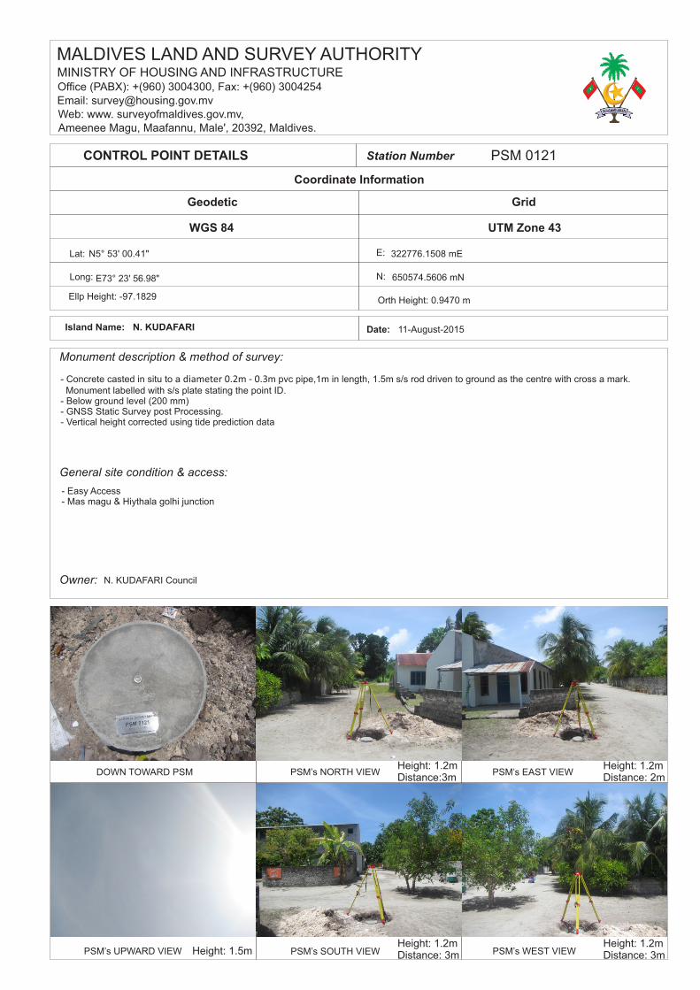
- Concrete casted in situ to a m pvc pipe,1m in length, 1.5m s/s rod driven to ground as the centre with cross a mark.diameter 0.2m ‐ 0.3 Monument labelled with s/s plate stating the point ID. - Below ground level (200 mm) - GNSS Static Survey post Processing. - Vertical height corrected using tide prediction data
Coordinate Information
WGS 84
Station Number PSM 0121
Lat:
Ellp Height: -97.1829
Geodetic
Long:
Monument description & method of survey:
UTM Zone 43
E:
Orth Height: 0.9470 m
Grid
N:
Owner:
General site condition & access:
CONTROL POINT DETAILS
DOWN TOWARD PSM
PSM’s UPWARD VIEW
PSM’s NORTH VIEW PSM’s EAST VIEW
PSM’s SOUTH VIEW PSM’s WEST VIEW
Date: 11-August-2015Island Name: N. KUDAFARI
MINISTRY OF HOUSING AND INFRASTRUCTUREOffice (PABX): +(960) 3004300, Fax: +(960) 3004254Email: [email protected]: www. surveyofmaldives.gov.mv,Ameenee Magu, Maafannu, Male', 20392, Maldives.
MALDIVES LAND AND SURVEY AUTHORITY
- Easy Access- Mas magu & Hiythala golhi junction
N. KUDAFARI Council
Height: 1.2mDistance:3m
Height: 1.2mDistance: 2m
Height: 1.2mDistance: 3m
Height: 1.2mDistance: 3mHeight: 1.5m
322776.1508 mE
650574.5606 mN
N5° 53' 00.41"
E73° 23' 56.98"
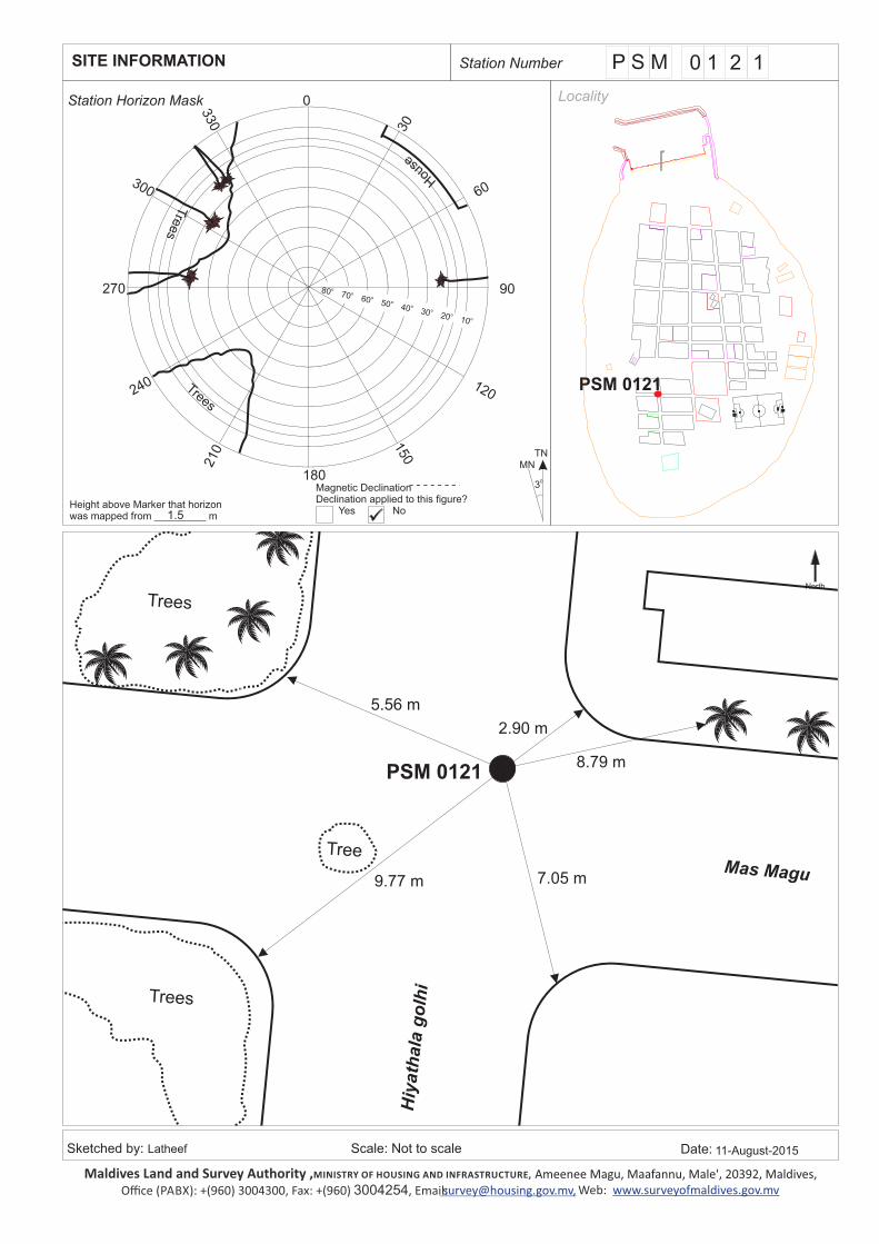
SITE INFORMATION Station Number
LocalityStation Horizon Mask
Height above Marker that horizon
0
was mapped from _________ m
330
30
180150
210
90
60
120
270
240
300
Magnetic DeclinationDeclination applied to this figure?
Yes No
80 o
70 o
60 o
50 o
40 o
30 o
20 o
10 o
MN
03
TN
North
Sketched by: Scale: Not to scale Date:
Ameenee Magu, Maafannu, Male', 20392, Maldives,Maldives Land and Survey Authority ,MINISTRY OF HOUSING AND INFRASTRUCTURE,
Web: [email protected], www.surveyofmaldives.gov.mvOffice (PABX): +(960) 3004300, Fax: +(960) 3004254, Email:
1.5
Latheef 11-August-2015
P S M 0 1 2 1
Tre
es
Trees
7.05 m
8.79 m
2.90 m
5.56 m
Hiy
ath
ala
go
lhi
Mas Magu
Trees
Tree
PSM 0121
9.77 m
Trees
House
PSM 0121
Coordinate Information
WGS 84
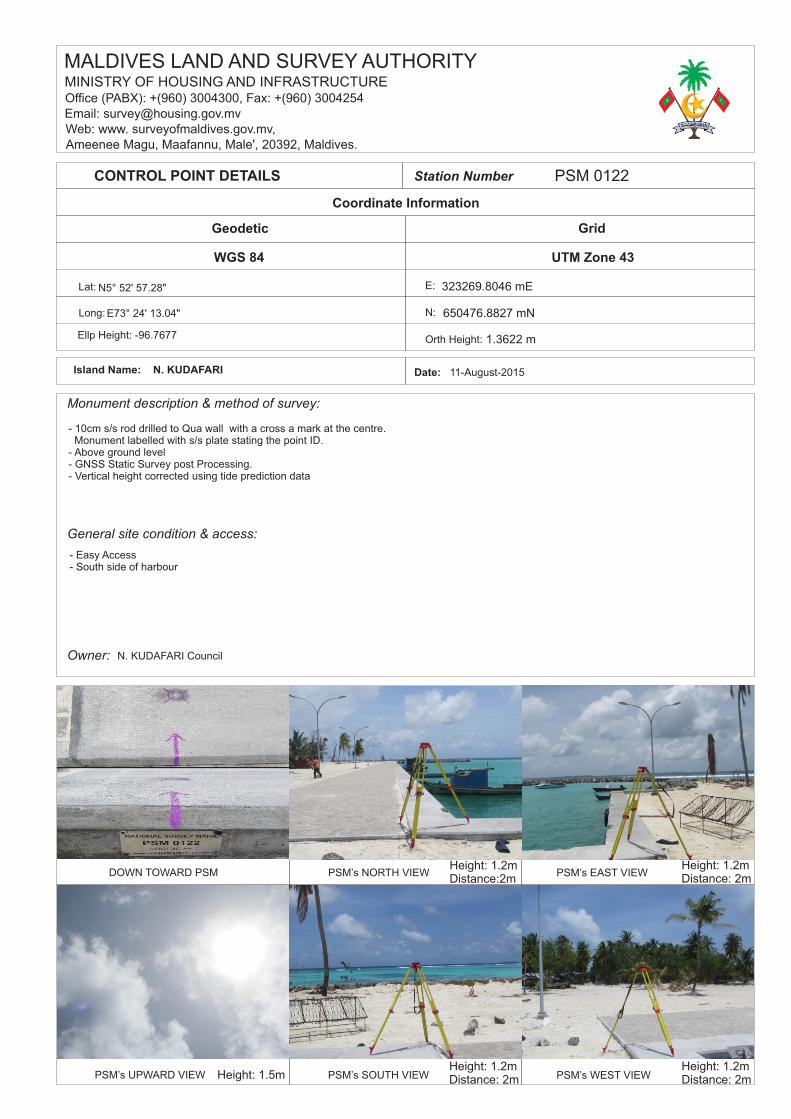
Station Number PSM 0122
Lat:
Ellp Height: -96.7677
Geodetic
Long:
Monument description & method of survey:
UTM Zone 43
E:
Orth Height:
Grid
N:
Owner:
General site condition & access:
CONTROL POINT DETAILS
DOWN TOWARD PSM
PSM’s UPWARD VIEW
PSM’s NORTH VIEW PSM’s EAST VIEW
PSM’s SOUTH VIEW PSM’s WEST VIEW
Date: 11-August-2015Island Name: N. KUDAFARI
MINISTRY OF HOUSING AND INFRASTRUCTUREOffice (PABX): +(960) 3004300, Fax: +(960) 3004254Email: [email protected]: www. surveyofmaldives.gov.mv,Ameenee Magu, Maafannu, Male', 20392, Maldives.
MALDIVES LAND AND SURVEY AUTHORITY
- Easy Access- South side of harbour
N. KUDAFARI Council
Height: 1.2mDistance:2m
Height: 1.2mDistance: 2m
Height: 1.2mDistance: 2m
Height: 1.2mDistance: 2mHeight: 1.5m
323269.8046 mE
650476.8827 mN
1.3622 m
E73° 24' 13.04"
N5° 52' 57.28"
- 10cm s/s rod drilled to Qua wall with a cross a mark at the centre. Monument labelled with s/s plate stating the point ID. - Above ground level - GNSS Static Survey post Processing. - Vertical height corrected using tide prediction data

Station Horizon Mask
Height above Marker that horizon
0
was mapped from _________ m
180150
210
90
60
120
270
240
300
Magnetic DeclinationDeclination applied to this figure?
Yes No
80 o
70 o
60 o
50 o
40 o
30 o
20 o
10 o
MN
03
TN
North
Sketched by: Scale: Not to scale Date:
1.5
Qu
ay w
all
Lamp
Lamp
Pavem
en
t
Lamp
13.81 m
17.16 m
1.09 m
17.51 m
6.38 m
5.24 m
PSM 0122
Harb
ou
r
Lam
p
Lam
p
Foot
ball
MOSQUE
MO
SQU
E
LOWTIDE
LOWTIDE
LOWTIDE
LOWTIDE
LOWTIDE
LOWTIDE
LOWTIDE
LOWTIDE
LOWTIDE
LOWTIDE
LOWTIDE
LOWTIDE
LOWTIDE
LOWTIDE
LOWTIDE
VEGETATION VEGETATION
VEGETATION
VEGETATION
VEGETATION
VEGETATION
VEGETATION
VEGETATION
VEGETATION
VEGETATION
VEGETATION
VEGETATION
VEGETATION
VEGETATION
VEGETATION
Kuni
KUDAFARI
Kudafari Health
Maiz
Kudafari
Kudafari Power
Wathaniyya AN
Jetty
Gudhan
Lease
CP
CP
CP
CP
CP
CP
CP
CP
CP
CP
CP
Ameenee magu
Mas magu
Mas magu
Mas magu
Mas magu
Violet maguViolet magu Violet magu Violet magu
Lease
Lease Lease
Lease
Islaahee Oivaru
Madh
arus
ee ve
hi
Ijuthi
maae
e Ma
ruka
zu
Lease Land Oil
Husb
in
PROPOSED LAND FOR FARM
Namaadhuge
Nikagas
Nikagas
Nikagas
Nikagas
Nikagas
Nikagas Nikagas
Nikagas
Nikagas
Cha'n
dhane
e Magu
Cha'n
dhane
e Magu
Cha'n
dhane
e Magu
Moo M
aguMo
o Magu
Moo M
aguMo
o Magu
Moo M
agu
Cha'n
dhane
e Magu
Kaskoo
da Ma
gu
Kaskoo
da Ma
guBerebe
dhi Ma
gu
Berebe
dhi Ma
guBer
ebedhi
Magu
Berebe
dhi Ma
gu
Vaifila
a Golh
iVai
filaa G
olhi
Vaifila
a Golh
iVai
filaa G
olhi
Abadha
hhiyaa
Magu
Abadha
hhiyaa
Magu
Abadha
hhiyaa
Magu
Abadha
hhiyaa
Magu
Abadha
hhiyaa
Magu
Dha'n
buruh
Golhi
Dha'n
buruh
Golhi
Hiytha
la Golh
iHiy
thala G
olhi
Hiytha
la Golh
i
Maage
dha Go
lhiMa
agedha
Golhi
Kudhira
ythma
a Golh
iKud
hirayth
maa G
olhi
Ameenee maguAmeenee magu
Ameenee magu
Maiza
an Ma
gu Kaaminee Hi'ngun
Kaaminee Hi'ngunFunamaa Hi'ngun
Funamaa Hi'ngun
Cemetery
Kudafari Pri-
Reef
kureege
Kodhu
Ameenee magu
0.25m
PSM0120322771.7980 mE650422.4090
PSM0121322776.1508 mE650574.5606
PSM0122323269.8046 mE650476.8827
MTCC BM323208.6906 mE650547.9228
-0.21-0.550.190.20-0.07-0.36-0.30-0.10
1.36
-0.57-0.73-0.620.811.20
1.31
0.990.950.97
-0.51-2.48-2.67-2.97-2.95-2.581.221.051.041.07
-1.04-2.40-2.93-3.10-2.46-3.061.241.101.141.28
-1.06-2.55-3.23-3.33-2.73-3.111.251.171.28
-1.24-2.52-3.58-3.24-2.88-2.981.251.181.43
1.90-2.40-3.72-3.26-2.89-3.161.231.211.37
1.86-3.03-3.74-3.46-3.22-3.251.241.221.32
1.90-2.55-3.90-3.70-3.45-3.44-1.62
1.20
1.45
1.98-1.07-3.53-3.73-3.53-3.32-2.301.221.38
1.76
-0.96-3.42-3.89-3.47-3.11-2.631.21
1.24 1.92-1.45-3.47-3.34-3.43-2.70-3.111.201.27
-0.95-3.01-3.66-2.881.83
1.87
1.20
-1.14-1.66-3.46-3.691.85
-0.151.11
-1.06-3.52-3.49-2.03
-0.79-0.58-3.63-3.22
-1.57-3.62-3.65-1.42
-1.34-3.63-4.04-1.46
-1.63-3.69-3.80-4.45
-2.91-2.53-3.75-3.44-4.55-1.62
-10.26-6.86-3.49-3.19-2.19
-10.05-5.01-2.29
-10.11
1.85
-0.51
0.52
0.491.39
1.26
1.321.24
1.29
1.48 1.77
PROJECT TITLECLIENT
DATE02/12/2015
DWG NO
2015-017
SCALE
REV
0.0
1 : 750
SURVEYED DATE 11-13/08/2015
SURVEYOR NEESHAM
DRAWN BY LATHEEF
CHECKED BY SHAFEEU
CONTENTS LEGEND
BATHYMETRY OFN. KUDAFARI
OUT-SURVEY OF HARBOUR AREA
INFRASTRUCTURE DEPARTMENTMINISTRY OF HOUSING AND
INFRASTRUCTURE
BATHYMETRIC SURVEY OF N. KUDAFARI HARBOUR
MALDIVES LAND ANDSURVEY AUTHORITY
NOTES
ALL MEASUREMENTS ARE IN METERS. HORIZONTAL DATUM: UTM43N. VERTICAL DATUM: MSL
PAPER SIZE A3QUAY WALL
HIGH WATER LINE
LOW WATER LINE
REVETMENT
PUBLIC BLOCKS/BOUNDARY
PATHWAYS/FOOTPATHS
BREAK WATER
LAMP POST
RECLAIMED AREA
MEAN WATER LINE RESIDENTIAL BLOCKS TREE
9.93m
1.91m 8.24m
1.57m
8.48m 1.53m
9.32m
1.60m
4.76m
0.99m
4.10m
4.09m
0.96m
5.04m
155.25m
45.30m
7.75m
1.78m
6.77m
1.31m
0.96m
0.97m
0.96m
0.99m
0.96m
5.08m
90.29m
89.63m
8.41m
5.70m
7.39m
1.47m
1.16m
PSM 0122
Lamp
SITE INFORMATION Station Number
Locality
330
30
Ameenee Magu, Maafannu, Male', 20392, Maldives,Maldives Land and Survey Authority ,MINISTRY OF HOUSING AND INFRASTRUCTURE,
Web: [email protected], www.surveyofmaldives.gov.mvOffice (PABX): +(960) 3004300, Fax: +(960) 3004254, Email:
Latheef 11-August-2015
P S M 0 1 2 2