Embed Size (px)
Citation preview
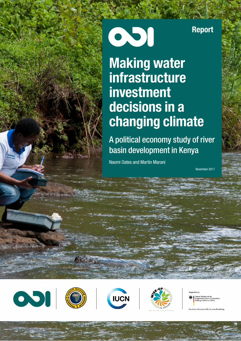
Making water infrastructure investment decisions in a changing climateA political economy study of river basin development in KenyaNaomi Oates and Martin Marani
November 2017
Report

Overseas Development Institute203 Blackfriars RoadLondon SE1 8NJ
Tel: +44 (0) 20 7922 0300 Fax: +44 (0) 20 7922 0399 E-mail: [email protected]
www.odi.org www.odi.org/facebook www.odi.org/twitter
Readers are encouraged to reproduce material from ODI publications for their own outputs, as long as they are not being sold commercially. As copyright holder, ODI requests due acknowledgement and a copy of the publication. For online use, we ask readers to link to the original resource on the ODI website. The views presented in this paper are those of the author(s) and do not necessarily represent the views of ODI.
© Overseas Development Institute 2017. This work is licensed under a Creative Commons Attribution-NonCommercial Licence (CC BY-NC 4.0).
Cover photo: Kenyan Water Resource Management Authority (WRMA) official at work in the Tana River watershed. Photo: Georgina Smith/CIAT (CC BY-NC-SA 2.0 license)
3
Acknowledgements
We are extremely grateful for the kind assistance provided by Prof Eric Odada, Prof Daniel Olago and Ms. Christine Atieno Omuombo and the rest of the team at the African Collaborative Centre for Earth System Science (ACCESS), University of Nairobi, who made this research possible. We are equally grateful for the expertise and advice provided by Mr William Mayaka (Independent), Prof Shem Wandiga (Chairman of ACCESS and Director of the Institute for Climate Change and Adaptation (ICCA) at the University of Nairobi) and Prof George Krhoda (University of Nairobi) at various stages of the research process. Thanks are also due to James Dalton and Rebecca Welling at the International Union for the Conservation of Nature (IUCN) for their steer and support throughout the project.
Peer review was provided by Prof Shem Wandiga (Chairman of ACCESS and Director of the Institute for Climate Change and Adaptation (ICCA) at the University of Nairobi), Prof George Krhoda and Ms. Christine Atieno Omuombo (University of Nairobi), Mr William Mayaka (Independent), Anil Markandya and Laetitia Pettinotti (BC3), Matthew McCartney (IWMI) and Peter Newborne (ODI). Beatrice Mosello (ODI) also provided inputs and comments to the methodology and early drafts of this report.
Finally, we would like to thank all the people we interviewed during the project who gave their time so generously and engaged in an open and constructive manner throughout.
All quotations from interviewees are anonymous. Any errors or omissions are our own. This work was undertaken as part of the Water Infrastructure Solutions from Ecosystem Services Underpinning
Climate Resilient Policies and Programmes (WISE-UP to Climate) project. The project is generating knowledge on how to implement mixed portfolios of built water infrastructure (e.g., dams, levees, irrigation channels) and ‘natural infrastructure’ (e.g., wetlands, floodplains, forests) that contribute to poverty reduction; water, energy and food security; biodiversity conservation; and climate resilience at a landscape scale. ‘WISE-UP to Climate’ aims to demonstrate the application of optimal portfolios of built and natural infrastructure developed through dialogue with stakeholders and decision-makers at multiple levels (local to national) to identify and find consensus on trade-offs. The project also seeks to link ecosystem services to water infrastructural development in the Volta River Basin (Ghana, principally, and also Burkina Faso) as well as the Tana River Basin in Kenya.
The project is a global partnership led by the International Union for Conservation of Nature (IUCN) and involves the Council for Scientific and Industrial Research - Water Research Institute (CSIR-WRI); African Collaborative Centre for Earth System Science (ACCESS), University of Nairobi; International Water Management Institute (IWMI); Overseas Development Institute (ODI); University of Manchester; and the Basque Centre for Climate Change (BC3).
This project is part of the International Climate Initiative. Bundesministerium für Umwelt, Naturschutz, Bau und Reaktorsicherheit (BMUB) (Federal Ministry for the Environment, Nature Conservation, Building and Nuclear Safety), Germany, support this initiative on the basis of a decision adopted by the German Bundestag.
For further details about the project, visit: www.waterandnature.org or www.iucn.org/water_wiseup
4
Contents
Acknowledgements 3
List of boxes, figures and tables 5
Abbreviations 7
Executive summary 8
1. Introduction 11
1.1. Investing in natural and built water infrastructure 11
1.2. Understanding the political economy of decision-making 11
1.3. Research approach and methods 12
2. The Kenyan context 15
2.1. National development challenges and ambitions 15
2.2. Tana River Basin 19
2.3. Case study 1: meeting Nairobi’s water needs through inter-basin transfers 22
2.4. Case study 2: the multipurpose High Grand Falls Dam 24
3. Research findings 27
3.1. The decision-making process for large water infrastructure projects in Kenya 27
3.2. Systemic constraints in coordinating water infrastructure investments in the Tana River Basin 28
3.3. Key actors, their priorities and influence on the water infrastructure decision-making process 33
3.4. Accounting for natural infrastructure in investment decisions 40
3.5. Accounting for climate change in investment decisions 44
4. Conclusions and recommendations 48
4.1. Key findings 48
4.2. Recommendations for policy-makers 50
4.3. Recommendations for development partners 51
References 53
Appendix 1: Stakeholders consulted 60
Appendix 2: Maps of planned infrastructure 62
5
List of boxes, figures and tables
Boxes
Box 1: Research questions 13
Box 2: Formal water sector institutions in Kenya 16
Box 3: Key institutions for climate change in Kenya 17
Box 4: Livelihoods in the Tana Basin 22
Box 5: A short history of High Grand Falls Dam 25
Box 6: Planning processes for water resource management and development in Tana Basin 29
Box 7: Whose data? 30
Box 8: National revenue allocations 31
Box 9: Land use planning in the Tana Delta 42
Figures
Figure 1: The layered approach to political economy analysis in WISE-UP 12
Figure 2: Map showing the boundaries of the Tana River Basin, its counties and key natural features 21
Figure 3: Planning and implementing the Northern Water Collector Tunnel in a changing governance context 24
Figure 4: Planning the High Grand Falls Dam in a changing governance context 26
Figure 5: The influence and interest of different actors in making infrastructure investment and management decisions 41
Figure A1: Location of the Northern Water Collector Tunnel (Phases 1 and 2) and nearby forest area 62
Figure A2: Map showing the locations of existing and planned dams in the Tana Basin including High Grand Falls 63
6
Tables
Table 1: Primary data collection in Kenya for the political economy analysis 14
Table 2: Water, sanitation and electricity coverage estimates for Kenya 15
Table 3: Institutional changes under the 2016 Water Act 17
Table 4: Kenya’s policy priorities and sector development targets 20
Table 5: Water resources and infrastructure in the Tana Basin 21
Table 6: Current and projected water demands for Tana Basin 22
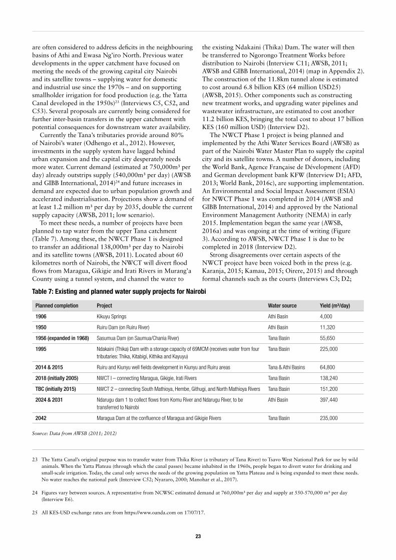
Table 7: Existing and planned water supply projects for Nairobi 23
Table 8: Key climate adaptation initiatives in Kenya 46
7
Abbreviations
AFD Agence Française de Dévelopment (French Development Agency)
APPP Africa Power and Politics Programme
ASALs Arid and semi-arid lands
AWSB Athi Water Services Board
BWRCs Basin Water Resource Committees (previously CAACs)
CAACs Catchment Area Advisory Committees (renamed Basin Water Resource Committees)
CIDP County Integrated Development Plan
CRA Commission on Revenue Allocation
DFID Department for International Development (UK)
E(S)IA Environmental (and Social) Impact Assessment
ESMP Environmental and Social Management Plan
EMCA Environmental Management and Coordination Act
GDP Gross domestic product
GoK Government of Kenya
ha Hectares
HGF High Grand Falls (Dam)
IFI International finance institution
IMF International Monetary Fund
IRDP Integrated Regional Development Plan
IUCN International Union for Conservation of Nature
IWMI International Water Management Institute
(I)WRM (Integrated) Water Resources Management
JICA Japanese International Cooperation Agency
KenGen Kenya Electricity Generating Company
KES Kenyan Shilling
KFS Kenya Forestry Service
KFW Kreditanstalt für Wiederaufbau (German Development Bank)
KWS Kenya Wildlife Service
KWTA Kenya Water Towers Agency
LAPSSET Lamu Port and South Sudan-Ethiopia Transport corridor
LCDA LAPSSET Corridor Development Authority
LUP Land-use plan
MALF Ministry of Agriculture, Livestock and Fisheries
MCM Million Cubic Metres
MENR Ministry of Environment and Natural Resources
MEP Ministry of Energy and Petroleum
MIC Middle Income Country
MUWASCO Murang’a Water and Sanitation Company
MW Megawatt
MWI Ministry of Water and Irrigation
NCCAP National Climate Change Action Plan
NCCRS National Climate Change Response Strategy
NCWSC Nairobi City Water and Sewerage Company
NEMA National Environment Management Authority
NGO Non-governmental organisation
NIB National Irrigation Board
NRM Natural Resources Management
NWCT Northern Water Collector Tunnel
NWMP National Water Master Plan
NWF Nairobi Water Fund
ODI Overseas Development Institute
PEA Political Economy Analysis
SEA Strategic Environmental Assessment
TARDA Tana and Athi Rivers Development Authority
TRDA Tana River Development Authority (renamed TARDA)
TEEB The Economics of Ecosystems and Biodiversity
TRDC Tana River Development Company (no longer exists)
UNCRD United Nations Centre for Regional Development
USD United States Dollar
WAB Water Appeals Board (renamed Water Tribunal)
WASH Water Supply and Sanitation and Hygiene
WASREB Water Services Regulatory Board
WISE-UP Water Infrastructure Solutions from Ecosystem Services underpinning Climate Resilient Policies and Programmes
WRA Water Resources Authority (previously WRMA)
WRMA Water Resources Management Authority (renamed WRA)
WRUA Water Resources User Association
WSB Water Service Board (renamed WWDA)
WSP Water Service Provider
WSTF Water Services Trust Fund
WWDA Water Works Development Agency (previously WSB)
8
Executive summary
In many developing countries, investments to harness water resources for development have tended to focus on built infrastructure such as large dams for irrigation and hydropower production. Who truly benefits from these investments, and who pays their costs, however, remains contentious. Also unclear is the extent to which the health of natural ecosystems, and the services they provide to people and the environment, is considered. Built infrastructure projects can favour socio-economic development, but can also have negative impacts on local communities’ livelihoods, and may not always be the best response in the face of climate variability and change. The Water Infrastructure Solutions from Ecosystem Services Underpinning Climate Resilient Policies and Programmes (WISE-UP) project aims to demonstrate how natural infrastructure can be combined with built infrastructure in balanced investment portfolios to deliver economic and social development, while ensuring that people and the environment can adapt to the impacts of climate change.
Under the WISE-UP project, we conducted a political economy analysis to explore the contexts within which decisions about river basin development are made in Ghana and Kenya. Our goal was to understand the barriers to introducing natural infrastructure solutions in water management and development strategies, and identify entry points to address them. This report outlines the findings for Kenya, where we focused on two planned infrastructure developments in the Tana Basin: an inter-basin transfer from the upper Tana to Nairobi known as the Northern Water Collector Tunnel (NWCT) project and a large multipurpose dam (known as High Grand Falls (HGF
Dam). The methodology consisted of interviews with key respondents in government, donor organisations and civil society at the national and local levels, supplemented by documentary evidence.
Kenya has made notable progress in developing its economy over the last decade. The government has undertaken important economic and structural reforms, which have contributed to sustained economic growth. The country also has a thriving private sector and growing middle class, and plays a pivotal role as a regional economic hub. Nonetheless, poverty levels remain high and Kenya faces a number of deep-seated challenges in achieving its goal to reach middle-income status within the next 15 years. Inadequate infrastructure, amongst other factors, continues to hamper economic and social development. Built water infrastructure, such as dams for hydropower or urban water supply, features prominently in key policies and strategies driving Kenya’s development. Such investments are viewed as an important means to achieve the aims laid out in Vision 2030 – the blueprint that guides Kenya’s national development – as well as to adapt to the impacts of climate change.
Within the water sector, Kenya has a comprehensive regulatory and institutional framework for water resources management as well as water and sanitation service delivery, underpinned by the 2002 Water Act (revised in 2016). Plans for river basin development – encompassing projects in water-related sectors such as energy and irrigation – are laid out in the National Water Master Plan (NWMP) 2030 (updated in 2013). Nonetheless, our first main finding is that, in practice, water governance and
• Kenya’s need for water infrastructure investment is urgent – the country is becoming increasingly water scarce due to population growth and rising demand across sectors, and climate change poses additional risks. Both ‘natural’ and built infrastructure could play a vital role in supporting resilient river basin development.
• Although policy-makers recognise the need to protect river catchments and ecosystems (natural infrastructure), in practice, built infrastructure development and management is often prioritised, resulting in missed opportunities. Water governance is also highly fragmented, making strategic integrated approaches difficult.
• The devolution process currently underway – driven by the 2010 Constitution – offers opportunities (and challenges) for water governance, creating spaces for actors to negotiate existing arrangements and form new alliances. The Constitution also requires public participation in decision-making, safeguards rights to water and a clean environment, and strengthens regulatory authorities’ position.
• Significant progress has been made in establishing a framework for action on climate change in Kenya. Entry points for putting natural infrastructure on the climate change agenda include: the execution of the National Climate Change Act, implementation of the National Adaptation Plan and Green Economy Strategy, and formulation of County Integrated Development Plans.
Key messages
9
investment is highly fragmented, hindering strategic basin-level planning. Laws and policies for water-related sectors are often inconsistent, mandates overlap and sector siloes are strong. Few fora currently exist in which stakeholders can explore different portfolios of built and natural infrastructure, or negotiate trade-offs.
Our second finding is that, because developing big water infrastructure is considered a national priority in Kenya, it can be difficult politically to discuss alternatives or to contest projects. There are several large infrastructure projects planned for the Tana Basin with high political stakes, such as the HGF Dam and the NWCT. Such projects are attractive to politicians as ‘concrete’ symbols of progress and power, and can be a matter of national pride. In contrast, investments in natural infrastructure tend to be less attractive politically, despite offering substantial ecological and socio-economic benefits. This is partly because investments such as catchment protection are less visible and the results are not immediate, but also because their socio-economic impacts are difficult to prove.
Given the high stakes involved in infrastructure development, there is a risk that political interests push projects forward despite technical concerns or without following due process. At worst, this can shut down the formal public spaces where stakeholders can discuss development options and negotiate the distribution of risks and benefits. However, accountability and adherence to environmental regulations is improving. The new Constitution in 2010 has been an important landmark in improving governance and accountability in Kenya. It provides the framework for devolution and increased citizen participation, as well as protecting citizens’ rights to a clean and healthy environment.
Our third finding is that, following the 2010 Constitution and revised Water Act (2016), water governance arrangements are changing rapidly. Substantial functions, responsibilities and resources have been transferred from central government to the newly created county governments, including water service delivery. The process of devolution has also created new opportunities for local actors to influence the decisions made around centrally-led water infrastructure development. Water has become a major issue in county politics and there is a strong incentive for county politicians to be seen protecting local interests and securing benefits for their constituencies.
Fourthly, we found in our case studies that project proponents, politicians and other stakeholders have used three main strategies to promote or contest water infrastructure projects:
• Control of data and information: Data are collected by several government entities but the mechanisms to share and validate data are generally weak. Different institutions thus hold different data sets and stake their claims on this basis. Information may also be intentionally withheld from the public domain; this could be due, for instance, to political sensitivities (as in the HGF Dam case).
• Use of the media: In the NWCT’s case, both national- and county-level stakeholders have sought to use the media to influence decision-making and public opinion to their own advantage. While the ‘heat’ these debates generate has put project proponents and regulatory authorities under pressure to heed stakeholder demands, it has also been blamed for delaying project implementation.
• Recourse to the law: Stakeholder participation in project planning has increasingly become a point of leverage for county governments vis-a-vis national government agencies. Where public debate fails, formal (legal) processes are also available to hold project proponents to account; for example, recourse to the Environmental Tribunal to challenge an environmental licence.
The environment is recognised as a key pillar in Kenya’s national policy (Vision 2030), but in reality is often perceived as secondary to, or in conflict with, the goal of socio-economic development (our fifth finding). For instance, investments in built infrastructure to supply electricity or water appear to take precedence over investments in riverine conservation, because energy and water security supply are key priorities in national development. There is perhaps more interest (and action) where investments in natural infrastructure are perceived to be necessary for the sustainability of built infrastructure. For example, considerable funding is going into catchment protection in the upper Tana through the Nairobi Water Fund, in order to project the hydropower dams and water supply facilities. In project design, there are also requirements to consider downstream needs, securing environmental flows and water for other users. Evidence from our case studies suggests these needs are factored in, although much depends on how the infrastructure is subsequently managed.
Kenya has made great strides in formulating a Climate Change Policy and Act, building on cross-sectoral efforts to develop a climate change strategy and action plan, and green economy strategy (our sixth finding). The Climate Change Act establishes a regulatory and institutional framework for action on climate change, including mainstreaming climate change into sectoral and county development planning. Mechanisms are also in place for Kenya to access international climate finance. To date, most progress and funding has been in mitigation; adaptation efforts have tended to lag behind in strategic planning, coordination and action. However, numerous initiatives supported by development partners are underway. Climate change risks are being considered to some extent in catchment and water infrastructure planning, although technical capacity needs to be built.
Our analysis has identified several opportunities to support positive change in water governance in Kenya, with a view to a) promoting greater recognition of natural infrastructure in policies and investment decisions, and b) supporting climate resilient development. Recommendations for future action are below.
10
Recommendations for policy-makers:1. To enable strategic basin-level planning, mechanisms
(or fora) are needed for cross-sector collaboration, with clear leadership from the top (i.e. cabinet ministers). Strategic planning, whereby all the key players are around the table, is important to ensure that viable options for long-term basin development are identified and that potential trade-offs can be discussed transparently.
2. A mindset-change and re-organisation of government institutions may be required to overcome institutional rivalries and achieve Vision 2030. The core principle of any reform should be bringing services and other benefits to the Kenyan people, as per the Constitution. This means putting narrow political interests aside, and working with citizens to improve their social and economic wellbeing, protect the environment, and build resilience to climate change.
3. Counties should be involved in making strategic decisions for basin-wide development, not only in project-based consultations. Counties may also benefit from having their own basin-level fora, bringing together different stakeholders to build consensus around common concerns and negotiating upstream-downstream water needs.
4. Both natural and built infrastructure can play a role in supporting resilient river basin development. A priority is putting in place mechanisms that ensure climate change is factored into routine planning and budgeting. Integrated cross-sectoral approaches will also be important to optimise the use of both natural and built infrastructure for climate adaptation and mitigation.
Recommendations for development partners:1. The case needs to be made to policy-makers for
viable alternatives to ‘business as usual’ in river basin development, given future climate change. Results from modelling studies and other research can help demonstrate what these alternatives might look like. This evidence is likely to be well received by policy-makers in light of their aim to achieve Kenya’s Vision 2030 ambitions.
2. Support to regulatory authorities, civil society organisations and other stakeholder platforms is vital to ensure that the Constitution’s provisions are enforced, and decision-makers held to account. Giving these actors information and data about infrastructure options (and their impacts) could help to inform stakeholder positions vis-à-vis current basin development priorities. Other capacity needs relate to financial and human resources, technical skills and data management.
3. Providing assistance to the Climate Change Council and Directorate, sectoral agencies, Treasury and County Governments will be crucial in mainstreaming climate adaptation and mitigation into routine planning. Current entry points for getting natural infrastructure onto the agenda include implementing the National Adaptation Plan and Green Economy Strategy, and preparing County Integrated Development Plans.
11
1. Introduction
1.1. Investing in natural and built water infrastructureIn the 21st century, climate change and natural resource degradation pose one of the most urgent and unprecedented risks to the global economy (NCE, 2015). Their effect on growth and development is reinforced by patterns of human development, including land use change, industrialisation, urbanisation, expansion of commercial agriculture and population growth (Vörösmarty et al., 2005). The poor, whose livelihoods often depend on natural resources and ecosystems, are disproportionately affected (Dercon, 2012).
Water will be the primary channel through which society, especially the poor, feels the impacts of climate change and environmental degradation. Water is an essential input for industry, energy production and agriculture, and supports human welfare. However, water also generates risks: droughts, which undermine food security and agricultural production; floods, which devastate infrastructure and destroy lives; waterborne diseases, which affect human health; and scarcity and competition, which can drive conflict, political instability and migration (WWAP, 2012).
Rivers are an essential water source and healthy river ecosystems provide important services to humans. How to manage rivers for multiple benefits and to mitigate risks is thus a critical question for water security and other key policies, such as poverty reduction and climate adaptation (Tickner et al., 2017). To date, responses have focused primarily on built infrastructure to store and regulate water, whilst the natural environment tends to be viewed as a source of risk and uncertainty (Parker and Oates, 2016). However, views are changing and there is growing interest worldwide in the benefits associated with river restoration (e.g. Auerbach et al., 2014; Lewis et al., 2008; Gilvear et al., 2013).
Some academics are also advocating for a more integrative and nuanced approach to water management – one that recognises diverse societal and biophysical contexts, embraces uncertainty, and is based on principles of adaptive management and equity (Zeitoun et al., 2016). This requires a better understanding of how, and for whom, water security can be realised in complex settings, and across scales, given the inevitable trade-offs between different uses and users (Mason and Calow, 2012; Zeitoun et al., 2016; Parker and Oates, 2016). It also requires greater recognition of the environment’s role in
securing resilient outcomes, both in research and in policy interventions for water resources management.
The ‘WISE-UP to Climate’ project was conceived to address this gap. It demonstrates how natural infrastructure can be a ‘nature-based solution’ for climate change adaptation and sustainable development. The project is researching how to use mixed portfolios of built water infrastructure (e.g. dams, levees, irrigation channels) and ‘natural infrastructure’ (e.g. wetlands, floodplains, watersheds) in two river basins: the Volta River Basin in Ghana and Burkina Faso, and the Tana River Basin in Kenya. The project offers decision-makers a number of different tools and approaches to assess water infrastructure investment options, with a view to optimising the range of societal benefits that river basins and their ecosystems can provide. The WISE-UP approach thus combines decision-support models, economic valuation, and political economy analysis to illustrate and quantify the trade-offs of different investment portfolios and their impacts on different actors at different scales, from community to national level interests.
1.2. Understanding the political economy of decision-makingWISE-UP recognises that, if water resources are to be managed equitably and sustainably, due attention must be given to political and economic contexts and existing governance arrangements, alongside technical considerations. This report presents the results of a component of the WISE-UP project that investigated the political economy dimensions of decision-making over water infrastructure investments in Kenya. It examines underlying drivers, incentives and constraints to understand how stakeholders interact in pursuit of their interests – promoting some policy objectives or isolating others. The report’s objective is to identify existing opportunities to support positive change in water governance, including greater recognition of natural infrastructure in investment planning and policy-making. The same political economy dynamics can influence the shape of policies and decisions on adaptation to water-related impacts of climate change.
This chapter introduces the conceptual approach and methods used for the WISE-UP political economy research, and outlines the research questions. Chapter 2 provides background information on Kenya’s current development plans and trajectory, and how water resources feature in
12
them. The two case studies are also introduced. Both are large infrastructure projects planned for the Tana River Basin. The research results are detailed in Chapter 3, focusing on systemic factors and institutional challenges that condition the way in which the decision-making process over water infrastructure occurs (Layer 1); and the actors involved in decision-making, including their decision-logics, behaviours and incentives (Layer 2). Entry points for change, or ‘room for manoeuvre’ (Layer 3), to promote alternative approaches to river basin management and development in Kenya are discussed in Chapter 4 – the conclusions and recommendations.
1.3. Research approach and methodsAcknowledging that politics matters has been one of the trademarks of international development thinking and practice over the last decade (Matoso, 2016). Several authors (e.g. Fritz et al., 2009; Hudson and Leftwich, 2014) have argued that political and economic factors intrinsically influence whether and how reforms happen, and that poor development performance cannot be explained by technical or managerial factors alone. Regarding the water sector, Molle (2009) has argued that developing and managing resources is inherently a political process, characterised by shifting political alignments and contestations. Mechanisms for dispute
1 http://www.institutions-africa.org/
resolution, differentials in access to resources, and social or political structures, all shape power relations, interests and positions, and therefore decisions, stakes and claims to water resources (Cabral, 1998; Madison, 2007).
Political economy analysis (PEA) has emerged as a useful approach to understand national and sectoral dynamics surrounding policy-making and implementation. PEA provides a ‘systematic approach to analysing relationships between key structural factors (such as historical processes and environmental issues), institutions (formal and informal rules, norms and arrangements) and actors in a given country or sector context’ (Jones, 2015: p66; see also Landell-Mills et al., 2007; Booth, 2015). PEA methods are founded on the premise that institutional and structural features of the context in question shape the incentives facing relevant stakeholders and, therefore, their behaviour, leading to particular sector outcomes (Harris and Wild, 2013). Such analysis can be used to support more politically and culturally feasible development strategies, helping to set realistic expectations of what can be achieved (Mcloughlin, 2014), and is especially necessary where weak governance is an issue (Fritz et al., 2009).
The research conducted in Kenya followed the approach to political economy analysis adopted by the ODI-led ‘Africa Power and Politics Programme’ (APPP).1 A key tenant is that development in Africa is achieved by ‘working with the grain’ of norms and realities in
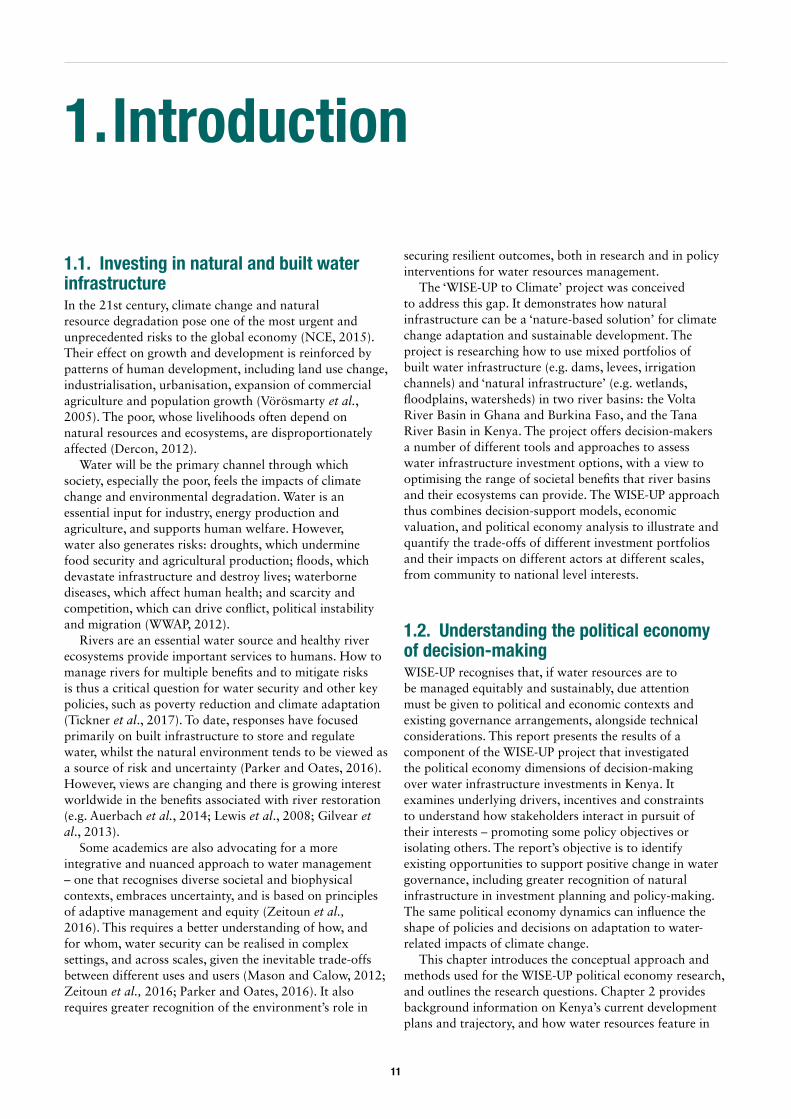
Systemic constraintsSystemic constraints and potentials arising from the political and economic context; the ‘rules of the political game’ and relations of power/influence at national and subnational levels.
Decision-making logicsDecision-making logics of relevant actors, or the factors influencing choices (incentives, interests, motivations, attitudes, so far as these can be captured.
Room for manoeuvre‘Dynamic aspects of change processes’, or entry points to introduce innovation to policy- and decision-making in water resource planning and investments in climate-compatible infrastructure.
Figure 1: The layered approach to political economy analysis in WISE-UP
Source: Authors, adapted from Booth and Golooba-Mutebi (2009).
13
the region, identifying and supporting the institutional arrangements capable of delivering public goods in the relevant cultural, social and political context. As mentioned above, a ‘layered’ approach to conceptualising and analysing the research problem was adopted, drawing on the methods used in an APPP study of the Ugandan road infrastructure sector (Booth and Golooba-Mutebi, 2009). The three layers, set out in Figure 1, consist of:
1. Systemic constraints arising from the political and economic context, or the ‘rules of the game’ (institutions and relations of power and influence, as well as economic factors), which drive decision-making.
2. Decision-making logics of key actors, looking at the factors influencing choices (i.e. incentives, interests, motivations, attitudes).
3. ‘Room for manoeuvre’, or the existing openings and blockages to introduce innovation to policy and decision-making in water resource planning and investments, including for climate change adaptation.
The study included an investigation of both formal institutions (their mandates and actions) and informal arrangements or interactions that are present in shaping decisions and determining outcomes, including facilitating (or blocking) decisions in line with the agenda that WISE-UP is aiming to promote. It starts from the assumption that there is currently insufficient inclusion of the concept of ‘natural infrastructure’ in planning and decision-making processes for climate change adaptation and water resources management, as well as little valuation of ecosystem services. The research questions that guided the study are presented in Box 1.
The approach is ‘issue-based’, focusing on the decisions and actors surrounding specific issues or case studies that present difficult water management problems for
2 Interviews and focus groups were semi-structured and conversational in tone. Data was captured by taking interview notes and by recording interviews verbatim. Permission was sought with interviewees before using recording equipment. All data collected and citations have been anonymised to maintain confidentiality.
apparently political reasons (e.g. resulting from conflicting powerful interests or institutional/governance weaknesses). These issues were identified during an initial scoping phase, and case studies were selected for further in-depth analysis. The cases for the Tana Basin in Kenya were: 1) the Northern Water Collector Tunnel (NWCT) project, which will transfer water from rural areas in the upper Tana Basin to Nairobi City; and 2) the High Grand Falls (HGF) Dam, a proposed large multipurpose dam that will support hydropower production, crop irrigation, water supply, fisheries and tourism. These water infrastructure projects raised a number of issues relevant to the WISE-UP project and research questions (Box 1). For example, are national policy frameworks, regulations or guidelines that are intended to govern river basin investments adhered to in practice? If not, how and by whom are decisions actually made, and using what criteria? What are the outcomes?
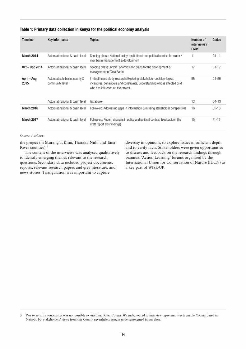
The methodology consisted of an initial literature review on water management and river basin development in Kenya and a rapid survey of the current national policies and strategies in key sectors (namely water, energy, agriculture/food, environment and climate change). Primary data was then collected through several sets of consultations with experts and project stakeholders over a two-year period, using interviews and focus group discussions (Table 1).2 Participants were selected purposively to capture relevant viewpoints, knowledge and experience (see Annex 1 for a list of institutions and groups consulted). They included actors at the national level (e.g. decision-makers in key government ministries and agencies), experts from academia, civil society representatives, and international development partners. Stakeholders working or living within the case study locations were also interviewed, for example, government officials in regional offices, representatives of the relevant County Governments, and local communities affected by
Box 1: Research questions
The WISE-UP political economy analysis was guided by the following research questions:
• How and who makes the decisions for developing and managing the river basin?• How are these decisions justified, negotiated or contested by different actors? What are the underlying
incentives, drivers and constraints? • Are trade-offs identified and managed when making infrastructure investment decisions? Is there a
mechanism for assessing different and competing options, or are narrow, sector-specific options favored and pursued?
• To what extent, and in what ways, is natural infrastructure (ecosystems) taken into account? • To what extent, and in what ways, are climate variability and change taken into account? • What opportunities are there for WISE-UP, and for stakeholders themselves, to promote alternative
approaches to river basin management and development?
Source: Authors
14
the project (in Murang’a, Kitui, Tharaka Nithi and Tana River counties).3
The content of the interviews was analysed qualitatively to identify emerging themes relevant to the research questions. Secondary data included project documents, reports, relevant research papers and grey literature, and news stories. Triangulation was important to capture
3 Due to security concerns, it was not possible to visit Tana River County. We endeavoured to interview representatives from the County based in Nairobi, but stakeholders’ views from this County nevertheless remain underrepresented in our data.
diversity in opinions, to explore issues in sufficient depth and to verify facts. Stakeholders were given opportunities to discuss and feedback on the research findings through biannual ‘Action Learning’ forums organised by the International Union for Conservation of Nature (IUCN) as a key part of WISE-UP.
Timeline Key informants Topics Number ofinterviews / FGDs
Codes
March 2014 Actors at national & basin level Scoping phase: National policy, institutional and political context for water / river basin management & development
11 A1-11
Oct – Dec 2014 Actors at national & basin level Scoping phase: Actors’ priorities and plans for the development & management of Tana Basin
17 B1-17
April – Aug 2015
Actors at sub-basin, county & community level
In-depth case study research: Exploring stakeholder decision-logics, incentives, behaviours and constraints; understanding who is affected by & who has influence on the project
56 C1-56
Actors at national & basin level (as above) 13 D1-13
March 2016 Actors at national & basin level Follow-up: Addressing gaps in information & missing stakeholder perspectives 16 E1-16
March 2017 Actors at national & basin level Follow-up: Recent changes in policy and political context; feedback on the draft report (key findings)
15 F1-15
Table 1: Primary data collection in Kenya for the political economy analysis
Source: Authors
15
2. The Kenyan context
4 In 2015 Kenya fell in the low human development category of the Human Development Index (UNDP, 2015).
5 $1.25 per day Purchasing Power Parity (2002-2012)
6 For example, deficiencies in energy and transport are a major productivity handicap for Kenyan firms (Ondiege et al., 2013).
7 Employment estimates for 2011; GDP and export estimates for 2015
8 Projections suggest a population of 60 million by 2030, of which 68% will be urban (WRMA, 2013a). Current population is estimated at over 45 million (UNData, 2016).
9 This includes computing services, banking, retail, transport services, etc (otherwise known as the tertiary sector) as opposed to production of food and raw materials (primary sector) or industry (secondary sector).
10 Kenya’s greenhouse gas emissions are relatively low (MENR, 2015).
2.1. National development challenges and ambitions
2.1.1. Current statusKenya has made notable economic progress over the last decade and is currently thought to have the potential to be ‘one of Africa’s great success stories’ (World Bank, 2016). The government has undertaken important economic and structural reforms which have contributed to sustained economic growth. The country also has a thriving private sector and growing middle class, and plays a pivotal role as a regional economic hub (World Bank, 2016).
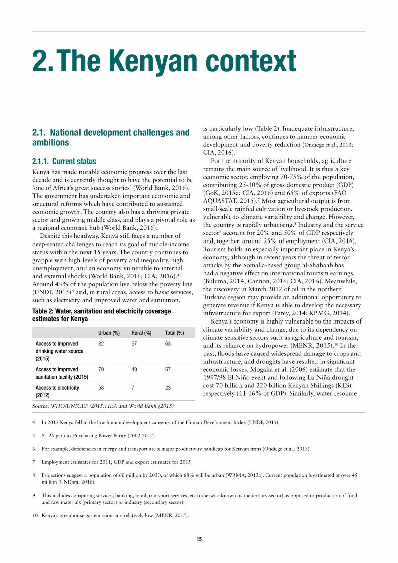
Despite this headway, Kenya still faces a number of deep-seated challenges to reach its goal of middle-income status within the next 15 years. The country continues to grapple with high levels of poverty and inequality, high unemployment, and an economy vulnerable to internal and external shocks (World Bank, 2016; CIA, 2016).4 Around 43% of the population live below the poverty line (UNDP, 2015) 5 and, in rural areas, access to basic services, such as electricity and improved water and sanitation,
is particularly low (Table 2). Inadequate infrastructure, among other factors, continues to hamper economic development and poverty reduction (Ondiege et al., 2013;
CIA, 2016).6
For the majority of Kenyan households, agriculture remains the main source of livelihood. It is thus a key economic sector, employing 70-75% of the population, contributing 25-30% of gross domestic product (GDP) (GoK, 2015c; CIA, 2016) and 65% of exports (FAO AQUASTAT, 2015).7 Most agricultural output is from small-scale rainfed cultivation or livestock production, vulnerable to climatic variability and change. However, the country is rapidly urbanising.8 Industry and the service sector9 account for 20% and 50% of GDP respectively and, together, around 25% of employment (CIA, 2016). Tourism holds an especially important place in Kenya’s economy, although in recent years the threat of terror attacks by the Somalia-based group al-Shabaab has had a negative effect on international tourism earnings (Buluma, 2014; Cannon, 2016; CIA, 2016). Meanwhile, the discovery in March 2012 of oil in the northern Turkana region may provide an additional opportunity to generate revenue if Kenya is able to develop the necessary infrastructure for export (Patey, 2014; KPMG, 2014).
Kenya’s economy is highly vulnerable to the impacts of climate variability and change, due to its dependency on climate-sensitive sectors such as agriculture and tourism, and its reliance on hydropower (MENR, 2015).10 In the past, floods have caused widespread damage to crops and infrastructure, and droughts have resulted in significant economic losses. Mogaka et al. (2006) estimate that the 1997/98 El Niño event and following La Niña drought cost 70 billion and 220 billion Kenyan Shillings (KES) respectively (11-16% of GDP). Similarly, water resource
Urban (%) Rural (%) Total (%)
Access to improved drinking water source (2015)
82 57 63
Access to improved sanitation facility (2015)
79 49 57
Access to electricity (2012)
58 7 23
Table 2: Water, sanitation and electricity coverage estimates for Kenya
Source: WHO/UNICEF (2015); IEA and World Bank (2015)
16
degradation is a big challenge, costing the economy 0.5% of GDP yearly.
Kenya’s development prospects are also considered to be threatened by weak governance and a political economy characterised by patronage and corruption (Hope Sr., 2014; CIA, 2016; Booth et al., 2014). After some early progress in tackling these issues, the previous government (2002-2013) was rocked by high-level scandals, and the World Bank and International Monetary Fund (IMF) suspended loans pending governmental action. Nevertheless, international financing institutions and bi-lateral donors have since resumed lending and remain important to Kenya’s economic development (KPMG, 2014).11 Election-related violence is another concern, and was particularly bad in the immediate aftermath of the 2007 general elections. Although the atmosphere remains tense since the 2017 elections, the 2013 elections were peaceful. In recent years, impelled by the 2010 Constitution, which outlaws police high-handedness, the government has come under increasing pressure to respect citizen freedoms.
The enactment of the new Constitution of Kenya (GoK, 2010a) has the potential to bring about a number of progressive changes in governance, providing for devolved government institutions and increased citizen participation. Substantial responsibilities have since been transferred from central Government to the newly created County Governments; the latter receive a minimum of 15% of state revenues per year. The Public Finance Management Act (GoK, 2012e) and County Government Act (GoK, 2012f) further strengthen counties’ legal status to manage
11 Kenya has also successfully raised capital in the global bond market. Kenya issued its first sovereign bond offering in mid-2014 (CIA, 2016).
their own budgets and develop plans in accordance with local priorities.
In the water sector, the Water Act of 2002 (revised in 2016) has also been an important landmark for reform, establishing new governance structures (Box 2, below; Table 3, overleaf) and devolving responsibilities for water development and service delivery to regional and local levels. The Act strengthened the political profile of water by introducing a strong principle of local participation, though it fell short of recognising customary water rights, which widely exist in practice (Rampa, 2011).
In addition to progress with water, there have been some notable achievements in laying down the institutional and legal framework for action on climate change. Important steps towards a multisectoral planning approach have been taken in putting together a National Climate Change Response Strategy in 2010 (NCCRS), followed by the National Climate Change Action Plan (NCCAP 2013-17; currently being updated), and a Green Economy Strategy and Implementation Plan (GESIP 2016-2030) (see GoK, 2010b; 2013b; 2016e). This collaborative process has culminated in the Climate Change Act of 2016, which provides a legal and institutional framework for Kenya’s climate change response (GoK, 2016a). The Act’s key features include establishing a National Climate Change Council and Directorate (Box 3, overleaf), and mainstreaming climate actions into sectoral and County Government functions. A Climate Finance Policy to establish a funding framework for all climate change activities in the country is also being finalised (Interviews D11, F6 and F11), and a National Climate Change Fund (NCCF) is being developed. These new institutional and
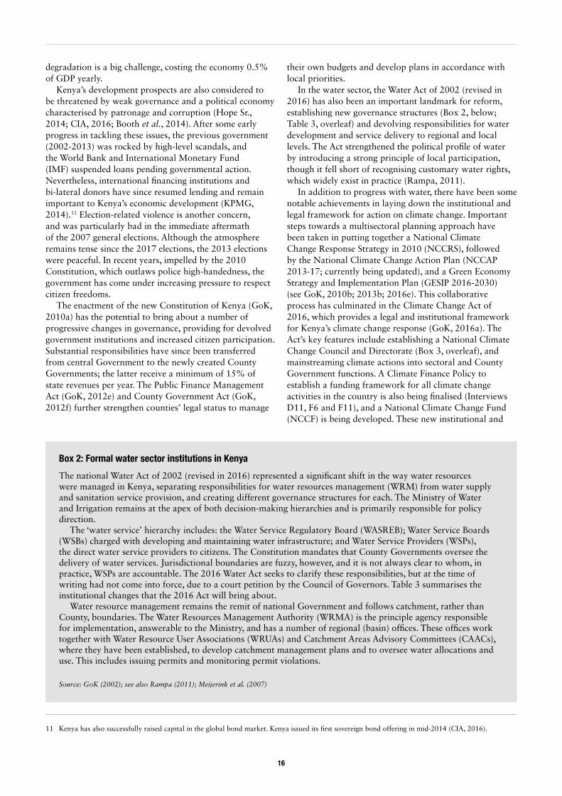
Box 2: Formal water sector institutions in Kenya
The national Water Act of 2002 (revised in 2016) represented a significant shift in the way water resources were managed in Kenya, separating responsibilities for water resources management (WRM) from water supply and sanitation service provision, and creating different governance structures for each. The Ministry of Water and Irrigation remains at the apex of both decision-making hierarchies and is primarily responsible for policy direction.
The ‘water service’ hierarchy includes: the Water Service Regulatory Board (WASREB); Water Service Boards (WSBs) charged with developing and maintaining water infrastructure; and Water Service Providers (WSPs), the direct water service providers to citizens. The Constitution mandates that County Governments oversee the delivery of water services. Jurisdictional boundaries are fuzzy, however, and it is not always clear to whom, in practice, WSPs are accountable. The 2016 Water Act seeks to clarify these responsibilities, but at the time of writing had not come into force, due to a court petition by the Council of Governors. Table 3 summarises the institutional changes that the 2016 Act will bring about.
Water resource management remains the remit of national Government and follows catchment, rather than County, boundaries. The Water Resources Management Authority (WRMA) is the principle agency responsible for implementation, answerable to the Ministry, and has a number of regional (basin) offices. These offices work together with Water Resource User Associations (WRUAs) and Catchment Areas Advisory Committees (CAACs), where they have been established, to develop catchment management plans and to oversee water allocations and use. This includes issuing permits and monitoring permit violations.
Source: GoK (2002); see also Rampa (2011); Meijerink et al. (2007)
17
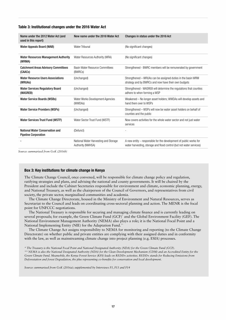
Name under the 2012 Water Act (and used in this report)
New name under the 2016 Water Act Changes in status under the 2016 Act
Water Appeals Board (WAB) Water Tribunal (No significant changes)
Water Resources Management Authority (WRMA)
Water Resources Authority (WRA) (No significant changes)
Catchment Areas Advisory Committees (CAACs)
Basin Water Resource Committees (BWRCs)
Strengthened - BWRC members will be remunerated by government
Water Resource Users Associations (WRUAs)
(Unchanged) Strengthened – WRUAs can be assigned duties in the basin WRM strategy and by BWRCs and now have their own budgets
Water Services Regulatory Board (WASREB)
(Unchanged) Strengthened - WASREB will determine the regulations that counties adhere to when forming a WSP
Water Service Boards (WSBs) Water Works Development Agencies (WWDAs)
Weakened – No longer asset holders; WWDAs will develop assets and hand them over to WSPs
Water Service Providers (WSPs) (Unchanged) Strengthened – WSPs will now be water asset holders on behalf of counties and the public
Water Services Trust Fund (WSTF) Water Sector Trust Fund (WSTF) Now covers activities for the whole water sector and not just water services
National Water Conservation and Pipeline Corporation
(Defunct) -
- National Water Harvesting and Storage Authority (NWHSA)
A new entity – responsible for the development of public works for water harvesting, storage and flood control (but not water services)
Source: summarised from GoK (2016b)
Table 3: Institutional changes under the 2016 Water Act
Box 3: Key institutions for climate change in Kenya
The Climate Change Council, once convened, will be responsible for climate change policy and regulation, ratifying strategies and plans, and advising the national and county governments. It will be chaired by the President and include the Cabinet Secretaries responsible for environment and climate, economic planning, energy, and National Treasury, as well as the chairperson of the Council of Governors, and representatives from civil society, the private sector, marginalised communities and academia.
The Climate Change Directorate, housed in the Ministry of Environment and Natural Resources, serves as Secretariat to the Council and leads on coordinating cross-sectoral planning and action. The MENR is the focal point for UNFCCC negotiations.
The National Treasury is responsible for securing and managing climate finance and is currently leading on several proposals; for example, the Green Climate Fund (GCF)* and the Global Environment Facility (GEF). The National Environment Management Authority (NEMA) also plays a role; it is the National Focal Point and a National Implementing Entity (NIE) for the Adaptation Fund.**
The Climate Change Act assigns responsibility to NEMA for monitoring and reporting (to the Climate Change Directorate) on whether public and private entities are complying with their assigned duties and in conformity with the law, as well as mainstreaming climate change into project planning (e.g. ESIA) processes.
* The Treasury is the National Focal Point and National Designated Authority (NDA) for the Green Climate Fund (GCF).** NEMA is also the National Designated Authority (NDA) for the Clean Development Mechanism (CDM) and an Accredited Entity for the Green Climate Fund. Meanwhile, the Kenya Forest Service (KFS) leads on REDD+ activities. REDD+ stands for Reducing Emissions from Deforestation and forest Degradation, the plus representing co-benefits for conservation and local development.
Source: summarised from GoK (2016a); supplemented by Interviews F5, F13 and F14
18
legislative frameworks indicate Kenya’s growing capacity to leverage and monitor climate finance to support activities at different levels (McGuire, 2017).
In lieu of the Climate Change Act, technical committees are being set up in key ministries to the mainstream climate change at sectoral level, including the Ministry for Water and Irrigation (Interviews F4 and F9).12 Meanwhile, a cross-sectoral working group has been established to plan and implement measures to fulfil Kenya’s Intended National Determined Contribution (INDC) as per the UNFCCC Paris Agreement (see MENR, 2015). The group mainly focuses on mitigation; for example, developing renewable energy sources and reducing emissions in the transport sector. A parallel group is yet to be established for adaptation (Interview F9), whose mandate would be to implement the National Adaptation Plan (NAP) (MENR, 2015; Interview F9). Several counties are also piloting the mainstreaming of climate change into their development plans, with support from the Adaptation Consortium, under the National Drought Management Authority (NDMA) (more in section 3.5).
2.1.2. Development prioritiesKenya’s national development agenda centres on Vision 2030 – an ambitious blueprint to rapidly industrialise and reach middle income status by 2030. Vision 2030 has three pillars: economic, social and political.13 Sector strategies, programmes and targets are expected to align with this vision (Table 4). Under the social pillar, Vision 2030 emphasises the need to ensure that economic development is both sustainable and equitable, and aims to provide a high quality of life for Kenya’s citizens, including a clean and secure environment (GoK, 2007; 2013).14 The Constitution of Kenya 2010 (Article 42) affirms this, recognising a healthy environment as a right and calling for ‘sustainable exploitation, utilization, management and conservation of the environment and natural resources’ (GoK, 2010a: p47). The need to protect the environment is echoed in various sector policies and strategies. In practice, however, safeguarding natural ecosystems is often secondary to other development priorities (see section 3.3).
Given the importance of smallholder farming in Kenya for food security, rural livelihoods and the economy, and the sector’s vulnerability to rainfall variability and
12 In MWI this includes an expert from each department within the ministry (Interview F3). Previously ministries were supposed to have a climate change desk, but many of these were inactive.
13 The economic pillar aims at achieving an average of 10% per year of economic growth (2012-30); the social pillar seeks to achieve a just, cohesive and equitable social development in a clean and secure environment; the political pillar aims for a democratic, issue-based, people-centred, result-oriented and accountable system in Kenya.
14 Although the Vision 2030 failed to account for climate change.
15 It is estimated that there are about 16 million smallholders living on an average of 0.47ha of farmland and producing 63% of all the food in the country (Rapsomanikis, 2015). As noted previously, agriculture employs around 75% of the population (including smallholders) and contributes 26-30% of GDP (GoK, 2015c; CIA, 2016).
16 Several key informants felt that this project was a political ‘dream’, being economically and environmentally unsound given the resources and infrastructure in the area (Interviews A1, A4, A11; see also Cannon, 2016) and the initial pledge of one million acres has been scaled down (Interviews D6, D9). Recent news reports indicate that the Treasury has slashed the project’s budget (Andae, 2016). Meanwhile the National Irrigation Board reports that they have made good progress in implementing the project (NIB, 2016).
climatic shocks (namely droughts and floods), supporting agricultural production is a priority for policy-makers (GoK, 2010b; 2010c).15 Yield increases are to be achieved primarily through intensification, facilitated inter alia by developing irrigation infrastructure and water storage structures. In 2013, the irrigation area was estimated to be just over 160,000ha, of which around 70,000ha lay in the Tana Basin (MALF, 2015). The National Water Master Plan (NWMP) sets a target of 623,700 hectares of irrigation by 2030 - significantly less than Vision 2030 – of which 162,000 hectares are planned for the Tana Basin (WRMA, 2013c). The government also hopes to develop commercial agriculture and attract private sector investment, including foreign direct investment, to generate employment and revenue (GoK, 2010c). This is a major focus of public-private projects such as the Galana-Kulalu Food Security Project – a ‘million acre’ irrigation scheme in Kilifi and Tana River Counties (Interviews D6 and D9; NIB, 2016).16 In the context of Vision 2030, Kenya is pursuing a modernised and competitive agricultural sector.
Demand for electricity is another big driver of public investment in Kenya. The Ministry of Energy is expected ‘to facilitate provision of clean, sustainable, affordable, reliable, and secure energy services for national development while protecting the environment’ (MEP, 2014). At present, Kenya’s generating capacity is around 2,300MW (2015 figure). To meet forecasted increases in demand, the target is to achieve 23,000MW by 2030 (KenGen, 2017) through the development of hydropower, geothermal, wind, and thermal (fossil fuel) energy (Interview A2; GoK, 2013c). The government is also aiming to reduce the proportion of hydropower in the energy mix (it was around 50% of generation capacity in 2012); in the context of growing water scarcity and periodic drought, hydropower is believed to be high risk (GoK, 2013c). In particular, the country has an established potential of between 7,000 and 10,000MW of geothermal energy in the Rift Valley, which could contribute to energy security as well as being a green energy source (GDC, 2016).
The Government of Kenya has a keen interest in large water and energy infrastructure projects due to their importance to the implementation of Vision 2030 flagship projects (MIED, 2015). The National Water Master Plan
19
(NWMP), updated in 2013, also recognises the strategic role of water storage structures (e.g. dams and reservoirs) and inter-basin water transfers in the optimisation of water resources in national and regional development (WRMA, 2013a). Although water infrastructure has been somewhat neglected in the past and fallen into disrepair (Mogaka et al., 2006), since the 2002 Water Act there have been considerable increases in investment from government, private investors and donors, most notably in water supply and sanitation subsector (Rampa, 2011). The need for water infrastructure investment is urgent – by 2030 water availability is projected to fall below the absolute water scarcity threshold of 500m³ per capita due to population increase (FAO AQUASTAT, 2015), whilst demand from all sectors is increasing (WRMA, 2013a). Furthermore, watersheds are increasingly degraded, with consequences for water quality – a concern highlighted in Vision 2030. Interestingly, the NWMP scales down some of the Vision 2030 targets, particularly for agriculture (Table 4, overleaf), recognising the need to maintain river flows, protect water quality and meet domestic needs.17
Climate change poses a considerable threat to Kenya’s development, but is also recognised as an opportunity to pursue greener, more resilient investment options, and support existing sector development priorities (GoK, 2016e). The potential to reduce dependence on hydropower and expand geothermal energy is one such synergy; another is reducing the impact of droughts and floods on agricultural production. In the water sector, expanding storage (through built infrastructure) and addressing catchment protection are viewed as important adaptation actions (Interviews E14 and F4). As such, many of Kenya’s climate adaptation and mitigation priorities reflect existing sector policies and targets (see Table 4).
It is estimated that up to 2030, Kenya requires over 40 billion USD in total for mitigation and adaptation actions across sectors (MENR, 2015). Whilst current funding is in the millions, rather than billions, Kenya is the second-largest recipient of climate finance in Africa (McGuire, 2017). There are numerous mitigation and adaptation initiatives underway supported through various funding channels. This includes a number of investments in green infrastructure and water-related developments (see McGuire, 2017 and section 3.5 for more details). To date, most progress has been made
17 Kenya’s Constitution states that “every person has a right […] to clean and safe water in adequate quantities” (GoK 2010: p31), whilst the Water Act recognises water as an economic good in addition to being a social good and fundamental human right.
18 The other major river basins are: Athi, Lake Victoria, Rift Valley Inland, Ewaso Ng’iro North, and Ewaso Ng’iro South.
19 Population estimate for 2010, based on estimated and predicted gridded population densities since 1990 (Baker et al., 2015).
20 This represents around 40% of total power (WRMA, 2013c). Note, however, that the proportion of hydroelectric power in Kenya’s energy mix is declining as alternative sources such as geothermal are developed.
21 Government-gazetted game parks and game reserves in the Tana River Basin include: Tsavo East National Park, Mt. Kenya National Park, Meru National Park, Arawale National Park and Reserve, Kora National Reserve, South Kitui National Reserve, Tana River Primate Reserve, Boni National Reserve, Dodori National Reserve, Abardare National Park, Mwingi National Reserve, Bisanadi National Reserve, Kiunga National Marine Reserve, and Mwea National Reserve (WRMA, 2013c). There are three major forest reserves: Mount Kenya Forest Reserve and Aberdare Range Forest Reserve (WRMA, 2013c) and Boni-Lungi Forest Reserve (GoK, 2016d). There are also several wildlife conservancies and sanctuaries.
on planning and funding mitigation activities, whereas action on adaptation has lagged behind and remains poorly coordinated in comparison (Interview F9; see also McGuire, 2017). However, this is expected to change with the implementation of the National Adaptation Plan and Climate Change Act.
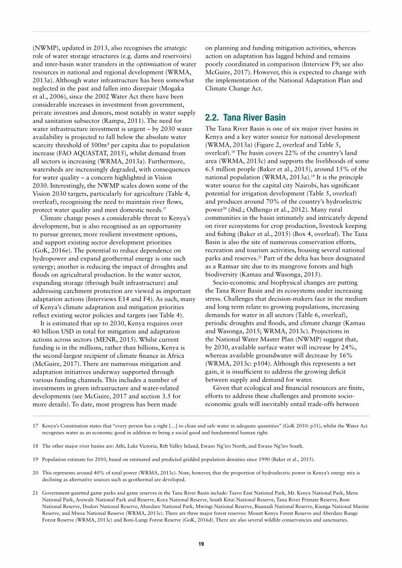
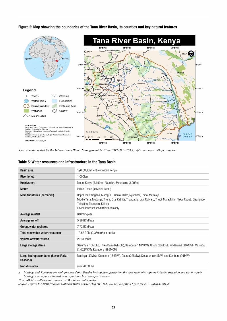
2.2. Tana River BasinThe Tana River Basin is one of six major river basins in Kenya and a key water source for national development (WRMA, 2013a) (Figure 2, overleaf and Table 5, overleaf).18 The basin covers 22% of the country’s land area (WRMA, 2013c) and supports the livelihoods of some 6.5 million people (Baker et al., 2015), around 15% of the national population (WRMA, 2013a).19 It is the principle water source for the capital city Nairobi, has significant potential for irrigation development (Table 5, overleaf) and produces around 70% of the country’s hydroelectric power20 (ibid.; Odhengo et al., 2012). Many rural communities in the basin intimately and intricately depend on river ecosystems for crop production, livestock keeping and fishing (Baker et al., 2015) (Box 4, overleaf). The Tana Basin is also the site of numerous conservation efforts, recreation and tourism activities, housing several national parks and reserves.21 Part of the delta has been designated as a Ramsar site due to its mangrove forests and high biodiversity (Kamau and Wasonga, 2015).
Socio-economic and biophysical changes are putting the Tana River Basin and its ecosystems under increasing stress. Challenges that decision-makers face in the medium and long term relate to growing populations, increasing demands for water in all sectors (Table 6, overleaf), periodic droughts and floods, and climate change (Kamau and Wasonga, 2015; WRMA, 2013c). Projections in the National Water Master Plan (NWMP) suggest that, by 2030, available surface water will increase by 24%, whereas available groundwater will decrease by 16% (WRMA, 2013c: p104). Although this represents a net gain, it is insufficient to address the growing deficit between supply and demand for water.
Given that ecological and financial resources are finite, efforts to address these challenges and promote socio-economic goals will inevitably entail trade-offs between
20
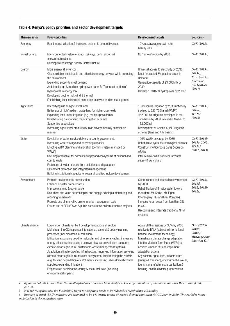
Theme/sector Policy priorities Development targets Source(s)
Economy Rapid industrialisation & increased economic competitiveness 10% p.a. average growth rateMIC by 2030
GoK (2013a)
Infrastructure Inter-connected system of roads, railways, ports, airports & telecommunicationsDevelop water storage & WASH infrastructure
No ‘remote’ region by 2030 GoK (2013a)
Energy More energy at lower costClean, reliable, sustainable and affordable energy services while protecting the environmentExpanding supply to meet demandAdditional large & medium hydropower dams BUT reduced portion of hydropower in energy mixDeveloping geothermal, wind & thermalEstablishing inter-ministerial committee to advise on dam management
Universal access to electricity by 2030Meet forecasted 8% p.a. increases in demandGeneration capacity of 23,000MW by 2030Develop 1,381MW hydropower by 2030a
GoK (2013a, 2013c); MEP (2014); Interview A2; KenGen (2017)
Agriculture Intensifying use of agricultural landBetter use of high/medium grade land for higher crop yieldsExpanding land under irrigation (e.g. multipurpose dams)Rehabilitating & expanding major irrigation schemes Supporting aquacultureIncreasing agricultural productivity in an environmentally sustainable manner
1.2million ha irrigation by 2030 nationally (revised to 623,700ha in NWMPb)482,000 ha irrigation developed in the Tana basin by 2030 (revised in NWMP to 162,000ha)Development of Galana-Kulalu irrigation scheme (Tana and Athi basins)
GoK (2013a, 2010c); WRMA (2013)
Water Devolution of water service delivery to county governmentsIncreasing water storage and harvesting capacityEffective WRM planning and allocation (permits system managed by WRMA)Securing a ‘reserve’ for domestic supply and ecosystems at national and county levelsProtection of water sources from pollution and degradationCatchment protection and integrated management Building institutional capacity for research and technology development
100% WASH coverage by 2030Rehabilitate hydro-meteorological networkConstruct multipurpose dams (focus on ASALs) Inter & intra-basin transfers for water supply & agriculture
GoK (2016b; 2013a, 2002); WRMA (2012, 2013)
Environment Promote environmental conservationEnhance disaster preparednessImprove planning & governanceDocument and value natural capital and supply; develop a monitoring and reporting framework Promote use of innovative environmental management tools Ensure use of SEAs/ESIAs & public consultation on infrastructure projects
Clean, secure and accessible environment by 2030Rehabilitation of 5 major water towers (Aberdare, Mt. Kenya, Mt. Elgon, Cherengany Hills and Mau Complex)Increase forest cover from less than 3% to 4%Recognise and integrate traditional NRM systems
GoK (2013a, 2013d, 2012, 2012b, 2012c)
Climate change Low-carbon climate resilient development across all sectorsMainstreaming CC responses into national, sectoral & county planning processes (incl. disaster-risk reduction)Mitigation: expanding geo-thermal, solar and other renewables; increasing energy efficiency; increasing tree cover; low-carbon/efficient transport; climate-smart agriculture; sustainable waste management systemsAdaptation: climate-proofing infrastructure; improving information services; climate-smart agriculture; resilient ecosystems; implementing the NWMP (e.g. tackling degradation of catchments; increasing urban domestic water supplies; expanding irrigation)Emphasis on participation, equity & social inclusion (including environmental impacts)
Abate GHG emissions by 30% by 2030 relative to BAUc (subject to international finance, investment, technology)Mainstream climate change adaptation into the Medium Term Plans (MTPs) to achieve Vision 2030 and implement adaptation actionsKey sectors: agriculture, infrastructure (energy & transport), environment & WASH, tourism, manufacturing, urbanisation & housing, health, disaster preparedness
GoK (2010b, 2013b; 2016a); MENR (2015); Interview D11
a By the end of 2013, more than 260 small hydropower sites had been identified. The largest numbers of sites are in the Tana River Basin (GoK, 2013c).
b NWMP recognises that the Vision2030 target for irrigation needs to be reduced to match water availability.c Business-as-usual (BAU) emissions are estimated to be 143 metric tonnes of carbon dioxide equivalent (MtCO2eq) by 2030. This excludes future exploitation in the extractive sector.
Table 4: Kenya’s policy priorities and sector development targets
21
Figure 2: Map showing the boundaries of the Tana River Basin, its counties and key natural features
Source: map created by the International Water Management Institute (IWMI) in 2015, replicated here with permission
a Masinga and Kiambere are multipurpose dams. Besides hydropower generation, the dam reservoirs support fisheries, irrigation and water supply. Masinga also supports limited water sport and boat transport services.
Note: MCM = million cubic metres; BCM = billion cubic metres Source: Figures for 2010 from the National Water Master Plan (WRMA, 2013a); Irrigation figure for 2013 (MALF, 2015)
Basin area 126,000km² (entirely within Kenya)
River length 1,000km
Headwaters Mount Kenya (5,199m); Aberdare Mountains (3,995m)
Mouth Indian Ocean (at Kipini, Lamu)
Main tributaries (perennial) Upper Tana: Sagana, Maragua, Chania, Thika, Nyamindi, Thiba, MathioyaMiddle Tana: Mutonga, Thura, Ena, Kathita, Thangatha, Ura, Rojwero, Thuci, Mara, Nithi, Naka, Ruguti, Bisanande, Thingithu, Thanantu, KithinuLower Tana: seasonal tributaries only
Average rainfall 840mm/year
Average runoff 5.86 BCM/year
Groundwater recharge 7.72 BCM/year
Total renewable water resources 13.58 BCM (2,369 m³ per capita)
Volume of water stored 2,331 MCM
Large storage dams Sasumua (16MCM), Thika Dam (69MCM), Kamburu (110MCM), Gitaru (20MCM), Kindaruma (16MCM), Masinga (1,402MCM), Kiambere (585MCM)
Large hydropower dams (Seven Forks Cascade)
Masinga (40MW), Kiambere (156MW), Gitaru (225MW), Kindaruma (44MW) and Kamburu (94MW)a
Irrigation area over 70,000ha
Table 5: Water resources and infrastructure in the Tana Basin
22
different stakeholder interests and policy objectives. To ensure a fair distribution of potential risks and benefits, such decisions need to be made strategically (informed by the best information available) and equitably. Nevertheless, they are likely to be highly contested and susceptible to capture by powerful elite interests. Understanding how, and by whom, decisions about the Tana Basin’s future are made is essential if we are to achieve more sustainable outcomes.
2.3. Case study 1: meeting Nairobi’s water needs through inter-basin transfersWater transfers are a means to tackle imbalances in the spatial distribution of water availability versus demand, and can be vital for economic and social development. This includes transfers between basins, within basins, and among water users. In many countries, rural-urban water transfers are increasing as cities expand. Molle and Berkoff cite a number of examples of ‘cities versus agriculture’ from Asia, Latin America, the US, Europe and North Africa (Molle and Berkoff, 2006; 2009). To date, there have been limited studies in sub-Saharan Africa, with a few notable exceptions (see Komakech et al., 2012; Newborne and Tucker, 2015; Hoover, 2001).22
The principle that water for drinking and domestic use takes precedence over other water uses is commonly
22 Komakech et al. (2012) document a case in the Pangani basin, Tanzania. Newborne and Tucker (2015) discuss of bulk water supply to Ouagadougou, in Burkina Faso. Hoover (2001) provides an analysis of the impact of the Lesotho Highlands Water Project (which transfers water to South Africa) on local communities in Lesotho.
enshrined in national laws and policies all over the world. Prioritising urban needs is further justified by economists’ tendency to view agriculture as an inefficient water user with a relatively low return compared to other uses – a view that is contested (Molle and Berkhoff, 2009). However, given that cities encompass a range of users, including industry, and often represent a concentration of powerful interests, questions need to be raised about equity, rights and entitlements of rural communities (Newborne and Tucker, 2015).
The Tana River Basin is a relatively water-rich catchment area in Kenya and water transfers from the Tana
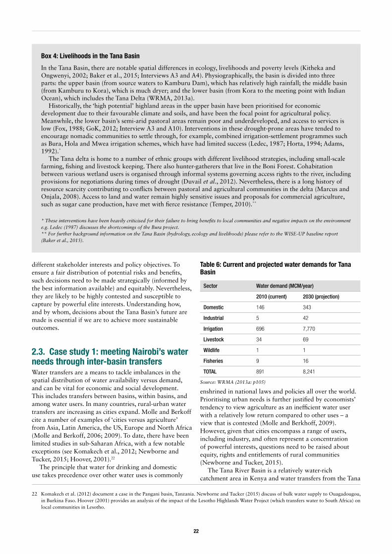
Box 4: Livelihoods in the Tana Basin
In the Tana Basin, there are notable spatial differences in ecology, livelihoods and poverty levels (Kitheka and Ongwenyi, 2002; Baker et al., 2015; Interviews A3 and A4). Physiographically, the basin is divided into three parts: the upper basin (from source waters to Kamburu Dam), which has relatively high rainfall; the middle basin (from Kamburu to Kora), which is much dryer; and the lower basin (from Kora to the meeting point with Indian Ocean), which includes the Tana Delta (WRMA, 2013a).
Historically, the ‘high potential’ highland areas in the upper basin have been prioritised for economic development due to their favourable climate and soils, and have been the focal point for agricultural policy. Meanwhile, the lower basin’s semi-arid pastoral areas remain poor and underdeveloped, and access to services is low (Fox, 1988; GoK, 2012; Interview A3 and A10). Interventions in these drought-prone areas have tended to encourage nomadic communities to settle through, for example, combined irrigation-settlement programmes such as Bura, Hola and Mwea irrigation schemes, which have had limited success (Ledec, 1987; Horta, 1994; Adams, 1992).*
The Tana delta is home to a number of ethnic groups with different livelihood strategies, including small-scale farming, fishing and livestock keeping. There also hunter-gatherers that live in the Boni Forest. Cohabitation between various wetland users is organised through informal systems governing access rights to the river, including provisions for negotiations during times of drought (Duvail et al., 2012). Nevertheless, there is a long history of resource scarcity contributing to conflicts between pastoral and agricultural communities in the delta (Marcus and Onjala, 2008). Access to land and water remain highly sensitive issues and proposals for commercial agriculture, such as sugar cane production, have met with fierce resistance (Temper, 2010).**
* These interventions have been heavily criticised for their failure to bring benefits to local communities and negative impacts on the environment e.g. Ledec (1987) discusses the shortcomings of the Bura project.** For further background information on the Tana Basin (hydrology, ecology and livelihoods) please refer to the WISE-UP baseline report (Baker et al., 2015).
Sector Water demand (MCM/year)
2010 (current) 2030 (projection)
Domestic 146 343
Industrial 5 42
Irrigation 696 7,770
Livestock 34 69
Wildlife 1 1
Fisheries 9 16
TOTAL 891 8,241
Table 6: Current and projected water demands for Tana Basin
Source: WRMA (2013a: p105)
23
are often considered to address deficits in the neighbouring basins of Athi and Ewasa Ng’iro North. Previous water developments in the upper catchment have focused on meeting the needs of the growing capital city Nairobi and its satellite towns – supplying water for domestic and industrial use since the 1970s – and on supporting smallholder irrigation for food production (e.g. the Yatta Canal developed in the 1950s)23 (Interviews C5, C52, and C53). Several proposals are currently being considered for further inter-basin transfers in the upper catchment with potential consequences for downstream water availability.
Currently the Tana’s tributaries provide around 80% of Nairobi’s water (Odhengo et al., 2012). However, investments in the supply system have lagged behind urban expansion and the capital city desperately needs more water. Current demand (estimated at 750,000m³ per day) already outstrips supply (540,000m³ per day) (AWSB and GIBB International, 2014)24 and future increases in demand are expected due to urban population growth and accelerated industrialisation. Projections show a demand of at least 1.2 million m³ per day by 2035, double the current supply capacity (AWSB, 2011; low scenario).
To meet these needs, a number of projects have been planned to tap water from the upper Tana catchment (Table 7). Among these, the NWCT Phase 1 is designed to transfer an additional 138,000m³ per day to Nairobi and its satellite towns (AWSB, 2011). Located about 60 kilometres north of Nairobi, the NWCT will divert flood flows from Maragua, Gikigie and Irati Rivers in Murang’a County using a tunnel system, and channel the water to
23 The Yatta Canal’s original purpose was to transfer water from Thika River (a tributary of Tana River) to Tsavo West National Park for use by wild animals. When the Yatta Plateau (through which the canal passes) became inhabited in the 1960s, people began to divert water for drinking and small-scale irrigation. Today, the canal only serves the needs of the growing population on Yatta Plateau and is being expanded to meet these needs. No water reaches the national park (Interview C52; Nyararo, 2000; Manohar et al., 2017).
24 Figures vary between sources. A representative from NCWSC estimated demand at 760,000m³ per day and supply at 550-570,000 m³ per day (Interview E6).
25 All KES-USD exchange rates are from https://www.oanda.com on 17/07/17.
the existing Ndakaini (Thika) Dam. The water will then be transferred to Ngorongo Treatment Works before distribution to Nairobi (Interview C11; AWSB, 2011; AWSB and GIBB International, 2014) (map in Appendix 2). The construction of the 11.8km tunnel alone is estimated to cost around 6.8 billion KES (64 million USD25) (AWSB, 2015). Other components such as constructing new treatment works, and upgrading water pipelines and wastewater infrastructure, are estimated to cost another 11.2 billion KES, bringing the total cost to about 17 billion KES (160 million USD) (Interview D2).
The NWCT Phase 1 project is being planned and implemented by the Athi Water Services Board (AWSB) as part of the Nairobi Water Master Plan to supply the capital city and its satellite towns. A number of donors, including the World Bank, Agence Française de Dévelopment (AFD) and German development bank KFW (Interview D1; AFD, 2013; World Bank, 2016c), are supporting implementation. An Environmental and Social Impact Assessment (ESIA) for NWCT Phase 1 was completed in 2014 (AWSB and GIBB International, 2014) and approved by the National Environment Management Authority (NEMA) in early 2015. Implementation began the same year (AWSB, 2016a) and was ongoing at the time of writing (Figure 3). According to AWSB, NWCT Phase 1 is due to be completed in 2018 (Interview D2).
Strong disagreements over certain aspects of the NWCT project have been voiced both in the press (e.g. Karanja, 2015; Kamau, 2015; Oirere, 2015) and through formal channels such as the courts (Interviews C3; D2;
Planned completion Project Water source Yield (m³/day)
1906 Kikuyu Springs Athi Basin 4,000
1950 Ruiru Dam (on Ruiru River) Athi Basin 11,320
1956 (expanded in 1968) Sasumua Dam (on Saumua/Chania River) Tana Basin 55,650
1995 Ndakaini (Thika) Dam with a storage capacity of 69MCM (receives water from four tributaries: Thika, Kitabigi, Kithika and Kayuyu)
Tana Basin 225,000
2014 & 2015 Ruiru and Kiunyu well fields development in Kiunyu and Ruiru areas Tana & Athi Basins 64,800
2018 (initially 2005) NWCT I – connecting Maragua, Gikigie, Irati Rivers Tana Basin 138,240
TBC (initially 2015) NWCT 2 – connecting South Mathioya, Hembe, Githugi, and North Mathioya Rivers Tana Basin 151,200
2024 & 2031 Ndarugu dam 1 to collect flows from Komu River and Ndarugu River, to be transferred to Nairobi
Athi Basin 397,440
2042 Maragua Dam at the confluence of Maragua and Gikigie Rivers Tana Basin 235,000
Table 7: Existing and planned water supply projects for Nairobi
Source: Data from AWSB (2011; 2012)
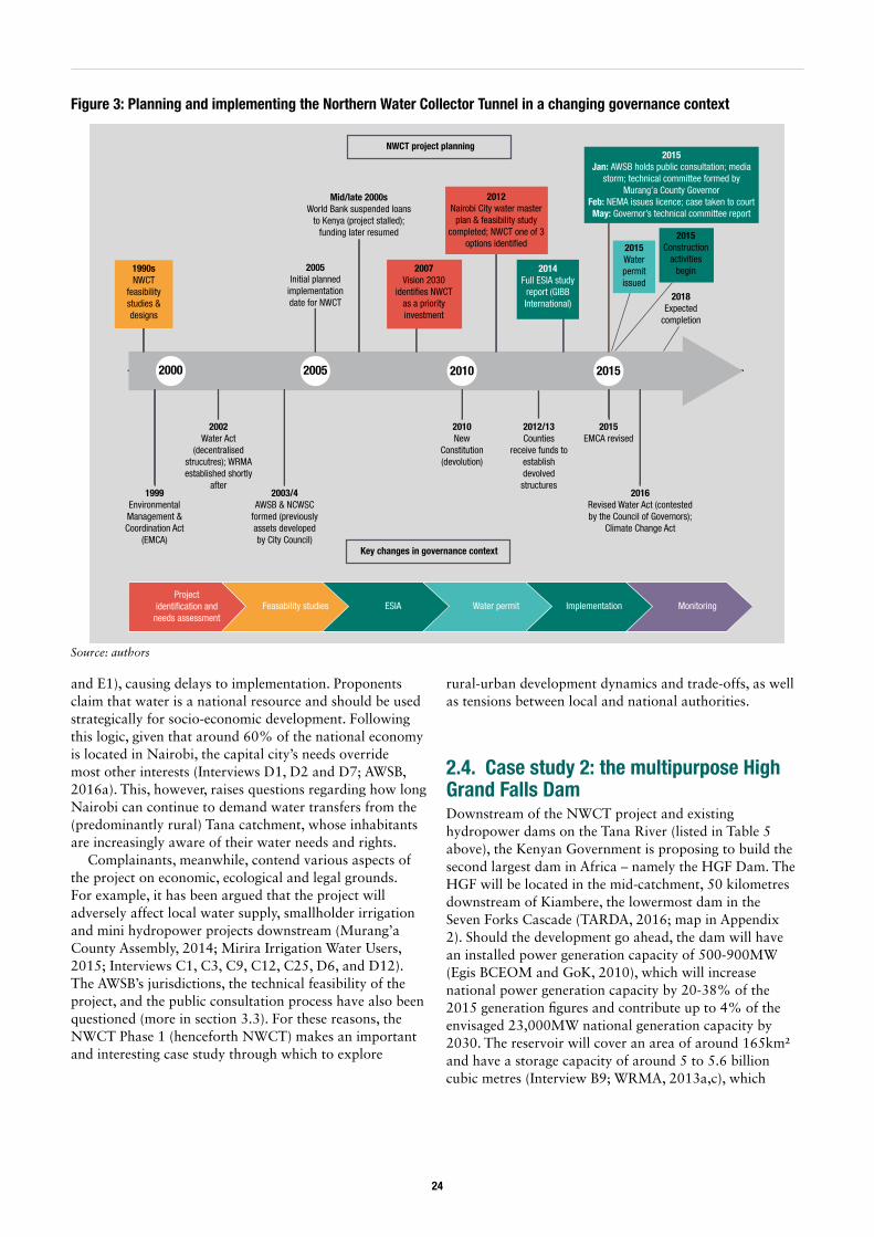
24
and E1), causing delays to implementation. Proponents claim that water is a national resource and should be used strategically for socio-economic development. Following this logic, given that around 60% of the national economy is located in Nairobi, the capital city’s needs override most other interests (Interviews D1, D2 and D7; AWSB, 2016a). This, however, raises questions regarding how long Nairobi can continue to demand water transfers from the (predominantly rural) Tana catchment, whose inhabitants are increasingly aware of their water needs and rights.
Complainants, meanwhile, contend various aspects of the project on economic, ecological and legal grounds. For example, it has been argued that the project will adversely affect local water supply, smallholder irrigation and mini hydropower projects downstream (Murang’a County Assembly, 2014; Mirira Irrigation Water Users, 2015; Interviews C1, C3, C9, C12, C25, D6, and D12). The AWSB’s jurisdictions, the technical feasibility of the project, and the public consultation process have also been questioned (more in section 3.3). For these reasons, the NWCT Phase 1 (henceforth NWCT) makes an important and interesting case study through which to explore
rural-urban development dynamics and trade-offs, as well as tensions between local and national authorities.
2.4. Case study 2: the multipurpose High Grand Falls DamDownstream of the NWCT project and existing hydropower dams on the Tana River (listed in Table 5 above), the Kenyan Government is proposing to build the second largest dam in Africa – namely the HGF Dam. The HGF will be located in the mid-catchment, 50 kilometres downstream of Kiambere, the lowermost dam in the Seven Forks Cascade (TARDA, 2016; map in Appendix 2). Should the development go ahead, the dam will have an installed power generation capacity of 500-900MW (Egis BCEOM and GoK, 2010), which will increase national power generation capacity by 20-38% of the 2015 generation figures and contribute up to 4% of the envisaged 23,000MW national generation capacity by 2030. The reservoir will cover an area of around 165km² and have a storage capacity of around 5 to 5.6 billion cubic metres (Interview B9; WRMA, 2013a,c), which
Figure 3: Planning and implementing the Northern Water Collector Tunnel in a changing governance context
2000 2005 2010 2015
1990sNWCT
feasibility studies & designs
1999Environmental Management & Coordination Act
(EMCA)
2002Water Act
(decentralised strucutres); WRMA established shortly
after2003/4
AWSB & NCWSC formed (previously assets developed by City Council)
2005Initial planned
implementation date for NWCT
Mid/late 2000sWorld Bank suspended loans
to Kenya (project stalled); funding later resumed
2007Vision 2030
identifies NWCT as a priority investment
2012Nairobi City water master
plan & feasibility study completed; NWCT one of 3
options identified
2014Full ESIA study
report (GIBB International)
2010New
Constitution (devolution)
2012/13Counties
receive funds to establish devolved structures
2015Jan: AWSB holds public consultation; media
storm; technical committee formed by Murang’a County Governor
Feb: NEMA issues licence; case taken to courtMay: Governor’s technical committee report
2015Water permit issued
2018Expected
completion
2015EMCA revised
2016Revised Water Act (contested by the Council of Governors);
Climate Change Act
Key changes in governance context
Project identification and
needs assessmentFeasability studies ESIA Water permit Implementation Monitoring
NWCT project planning
2015Construction
activities begin
Source: authors
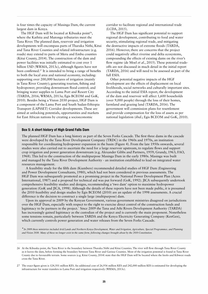
25
is four times the capacity of Masinga Dam, the current largest dam in Kenya.
The HGF Dam will be located at Kibuuka point26, where the Kathita and Mutonga tributaries meet the Tana River. The planned dam, reservoir and irrigation developments will encompass parts of Tharaka Nithi, Kitui and Tana River Counties and related infrastructure (e.g. roads) may extend to parts of Meru and Embu counties (Kitui County, 2014). The construction of the dam and power facilities was initially estimated to cost over 1 billion USD (WRMA, 2013c), although figures have not been confirmed.27 It is intended to bring a range of benefits to both the local area and national economy, including: supporting over 200,000 hectares of irrigation (mainly in Tana River County); generating tourism, fishing and hydropower; providing downstream flood control; and bringing water supplies to Lamu Port and Resort City (TARDA, 2016; WRMA, 2013a; Egis BCEOM and GoK, 2010). Besides being a Vision 2030 project, HGF Dam is a component of the Lamu Port and South Sudan-Ethiopia Transport (LAPSSET) Corridor developments. These are aimed at unlocking potentials, opportunities and markets for East African nations by creating a socioeconomic
26 At the Kibuuka point, the Tana River is the boundary between Tharaka Nithi and Kitui Counties. The river will flow through Tana River County as it leaves the dam, before forming the boundary between Tana River and Garissa Counties. Most of the irrigation potential is found in Tana River County due to favourable terrain. Some sources (e.g. Kitui County, 2014) state that the HGF Dam will be located where the Isiolo and Kibwezi roads cross the Tana River.
27 The exact figure given is 124,501 million KES. An additional cost of 26,936 million KES and 242,000 million KES is estimated for developing the infrastructure for water transfers to Lamu Port and irrigation respectively (WRMA, 2013c).
corridor to facilitate regional and international trade (LCDA, 2015).
The HGF Dam has significant potential to support regional development, contributing to food and water security, stimulating regional trade, and mitigating the destructive impacts of extreme floods (TARDA, 2016). However, there are concerns that the project could negatively affect riverine and delta ecosystems, compounding the effects of existing dams on the river’s flow regime (de Moel et al., 2015). These potential trade-offs are not discussed in much detail in the initial report (TARDA, 2016) and will need to be assessed as part of the full ESIA.
Other potential negative impacts of the HGF development are the effects of displacement on local livelihoods, social networks and culturally important sites. According to the initial ESIA report, the development of the dam and reservoir will affect 1,600 households (over 9,000 people) through the loss of their homes, farmland and grazing land (TARDA, 2016). The government will commission plans for resettlement and provide compensation for the loss of assets as per national legislation (ibid.; Egis BCEOM and GoK, 2010).
Box 5: A short history of High Grand Falls Dam
The planned HGF Dam has a long history as part of the Seven Forks Cascade. The first three dams in the cascade were developed by the Tana River Development Company (TRDC) in the 1960s and 1970s, an institution responsible for coordinating hydropower expansion in the basin (Figure 4). From the late 1950s onwards, several studies were also carried out to ascertain the need for a large reservoir upstream, to regulate flows and support crop irrigation and power generation downstream (e.g. Alexander Gibbs and Partners, 1959; Grundy, 1963; FAO, 1968). This led to the construction of the multipurpose Masinga Dam in the early 1980s. Masinga was built and managed by the Tana River Development Authority - an institution established to lead on integrated water resources management.
A feasibility study for the fifth dam (Kiambere) recommended detailed studies of HGF Dam (Engineering and Power Development Consultants, 1980), which had not been considered in previous assessments. The HGF Dam was subsequently promoted as a promising project in the National Power Development Plan (Acres International, 1987) and a proposal for technical aid was put forward (GoK, 1992). JICA subsequently undertook comprehensive feasibility studies and designs, recommending a ‘two dam’ option to maximise hydropower generation (GoK and JICA, 1998). Although the details of these reports have not been made public, it is presumed the 2010 feasibility and design studies by Egis BCEOM (2010) are an update of the 1998 assessments. A crucial difference is the decision to construct a single large (multipurpose) dam.
Upon its approval in 2009 by the Kenyan Government, various government ministries disagreed on jurisdictions over the HGF Dam, especially with respect to the right to exercise direct control of the construction funds and legitimacy to be partners in the project.* Since 2009 the Tana and Athi Rivers Development Authority (TARDA) has increasingly gained legitimacy as the custodian of the project and is currently the main proponent. Nonetheless some tensions remain, particularly between TARDA and the Kenya Electricity Generating Company (KenGen), which currently controls power generation and water releases from the Seven Forks Cascade.
* In 2009 these ministries included Arid Lands and Northern Kenya Development, Water and Irrigation, Agriculture, Special Programmes, and Planning and Vision 2030. Many of these no longer exist in the same form, following changes brought about by the 2010 Constitution.
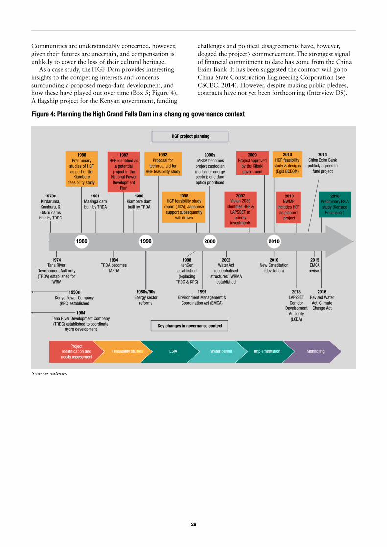
26
Communities are understandably concerned, however, given their futures are uncertain, and compensation is unlikely to cover the loss of their cultural heritage.
As a case study, the HGF Dam provides interesting insights to the competing interests and concerns surrounding a proposed mega-dam development, and how these have played out over time (Box 5; Figure 4). A flagship project for the Kenyan government, funding
challenges and political disagreements have, however, dogged the project’s commencement. The strongest signal of financial commitment to date has come from the China Exim Bank. It has been suggested the contract will go to China State Construction Engineering Corporation (see CSCEC, 2014). However, despite making public pledges, contracts have not yet been forthcoming (Interview D9).
1980 1990 2000 2010
1980Preliminary
studies of HGF as part of the
Kiambere feasibility study
1974Tana River
Development Authority (TRDA) established for
IWRM
1950sKenya Power Company
(KPC) established
1984TRDA becomes
TARDA
1992Proposal for
technical aid for HGF feasibility study
Key changes in governance context
Project identi�cation and
needs assessmentFeasability studies ESIA Water permit Implementation Monitoring
HGF project planning
1964Tana River Development Company (TRDC) established to coordinate
hydro development
1970sKindaruma, Kamburu, & Gitaru dams
built by TRDC
1980s/90sEnergy sector
reforms
1981Masinga dam built by TRDA
1987HGF identi�ed as
a potential project in the
National Power Development
Plan
1988Kiambere dam built by TRDA
1998HGF feasibility study
report (JICA); Japanese support subsequently
withdrawn
2000sTARDA becomes project custodian (no longer energy sector); one dam option prioritised
2007Vision 2030
identi�es HGF & LAPSSET as
priority investments
2009Project approved
by the Kibaki government
2010HGF feasibility
study & designs (Egis BCEOM)
2013NWMP
includes HGF as planned
project
2014China Exim Bank publicly agrees to
fund project
2016Preliminary ESIA study (Kenface
Enconsults)
1998KenGen
established (replacing
TRDC & KPC)
1999Environment Management &
Coordination Act (EMCA)
2002Water Act
(decentralised structures); WRMA
established
2010New Constitution
(devolution)
2013LAPSSET Corridor
Development Authority (LCDA)
2015EMCA revised
2016Revised Water Act; Climate Change Act
Figure 4: Planning the High Grand Falls Dam in a changing governance context
Source: authors
27
3. Research findings
28 The ESIA is a stepwise process and can be broken into several stages (here we have simplified). For example, a project may carry out preliminary studies and present a project report, which then is used to commission a full ESIA study (as is the case with the HGF Dam). Smaller projects may not require a full ESIA. Another important tool that NEMA uses to determine projects’ environmental sustainability is a strategic environmental assessments (SEA), which consider policies, plans and programmes, rather than projects. SEAs are relatively new and have only been applied in a few cases (e.g. the Tana Delta SEA).
29 For example, the ESIA for NWCT identified three project alternatives to supply water to Nairobi: well fields in Kiunyu and Ruiru; Margua Dam; and Northern Water Collector Tunnel. Upon analysis of project alternatives, the NWCT option was chosen for development (AWSB and GIBB International, 2014).
30 For example, the ESIA is advertised in national newspapers and sent to relevant agencies/experts for comment.
3.1. The decision-making process for large water infrastructure projects in KenyaAs a first step in our analysis, it is useful to outline how the decision-making process for large water infrastructure projects, such as dams, should proceed in theory in Kenya. In the remainder of the chapter, we use our two case studies to discuss the reality of decision-making, which is inevitably less straightforward in practice. One factor that has complicated the planning process for the HGF Dam and NWCT is the timeframe over which these projects have been gestating (see Figures 3 and 4). For example, the HGF Dam was first considered in the early 1980s as part of the Seven Forks Cascade, and a comprehensive feasibility study was conducted in the 1990s. Not only have the project designs evolved since then, so too have the national laws, regulations, policies and institutional arrangements informing infrastructure planning and implementation, as well as the everyday politics that emerge with such projects.
For large water infrastructure projects, the planning and implementation process currently has six main phases:.
3.1.1. Project identification and needs assessment Water infrastructure projects are first identified as part of a national or sub-national planning process, such as the National Water Master Plan or Nairobi City Water Master Plan. These should be consultative planning processes involving key stakeholders (e.g. government agencies and ministries, private sector and civil society), in which the viability of different options are assessed vis-à-vis development needs. Individual project plans, programmes and projects may feed into national development policies and strategies approved by the Cabinet (i.e. the President and Ministers) and promoted as flagship developments, with a view to securing the necessary finance. The NWCT is a Vision 2030 project, for example, whilst HGF is both a Vision 2030 and a LAPSSET project.
3.1.2. Feasibility studies The project proponent develops water infrastructure designs and commissions various technical, economic and social assessments to determine the proposed project’s viability, including a hydrological assessment. The latter contains a proposal for maintaining minimum flows to meet basic human needs and environmental flows downstream. The hydrological assessment is submitted to WRMA to obtain a water abstraction permit (Step 4)
3.1.3. Environmental and social impact assessment (ESIA)Comprehensive environmental and social assessments as well as stakeholder consultations are required for all big infrastructure projects in Kenya, as per the Constitution (GoK, 2010) and environmental regulations (GoK, 2015b).28 This work is contracted to consultants with the relevant expertise, who have to be registered with NEMA. The ESIA should cover inter alia:
• Siting and technology options, and an analysis of project alternatives (including a ‘no project’ option)29
• Risks to the project, including a section on climate change
• An assessment of social and environmental impacts (including magnitude, extent and sensitivity), culminating in an environmental and social management plan (ESMP)
• An assessment of community compensation and resettlement needs, culminating in a resettlement action plan (RAP).
Once an ESIA has been completed, it is submitted to NEMA for review. NEMA’s experts assess the quality of the ESIA and visit the proposed project site. Subject to their approval, project documents are made available to the public for comment.30 An environmental licence is then issued, valid for 24 months (the project has to be
28
commissioned within this period). Any objections to the licence have to be raised within 21 days. Once a licence has been issued it is difficult to revoke; grievances have to be addressed through the National Environment Tribunal or High Court of Kenya. Licences NEMA issues often contain conditions, for example requiring the project proponent to obtain approvals from County Governments and/or to acquire licences from other relevant Authorities.
3.1.4. Water permitting Water permits are required for all non-domestic water abstractions. Permit applications are first reviewed by the relevant WRMA sub-regional office and WRUA, before a public notification is issued. The public has seven days in which to raise objections. For large water infrastructure projects (categories C and D), the application is then forwarded to the regional and national WRMA offices for evaluation and approval. 31 The permit issued states the amount that can be stored and/or abstracted, which is typically a fixed amount based on dry season flows. The permit is conditional, in other words, subject to water availability (flow), and will only be issued once NEMA has given the project an environmental licence. Once issued, water abstraction licences can be contested through the Water Appeals Board (WAB) or the High Court of Kenya.
3.1.5. Implementation (construction) Once the necessary licences and permits have been issued and funding has been secured, the project can be tendered and constructed. Sometimes designs have to be altered during implementation to account for site conditions, or unexpected social and technological realities. Such changes may necessitate revision of the ESMPs and water permits through further studies and approval by NEMA and WRMA.
3.1.6. Monitoring (before, during and post-construction)Infrastructure managers are expected to develop and adhere to an Environmental and Social Management Plan (ESMP), which outlines measures to mitigate the risks or impacts identified in the ESIA. NEMA monitors implementation of the ESMPs and should be notified of any operational changes or malfunctions in the system. WRMA monitors water abstractions and pollution, and collects the relevant fees.
31 These are bulk abstractions of 5000-9999.9m³ (C) and up to 210,000m³ (D). WRMA determines which permit category is suitable for a project based on the designs and hydrological data available. If data is limited, WRMA may ask the applicant to conduct a hydrological survey. For category D projects (e.g. NWCT and HGF) WRUAs are not usually involved in decision-making, as they are thought to lack the technical capacity.
32 e.g. Environment and Land Court Act of 2011, Land Act of 2012, Land Registration Act of 2012, Community Land Act of 2016
3.2. Systemic constraints in coordinating water infrastructure investments in the Tana River Basin
3.2.1. Institutional fragmentation and entrenched interestsChallenges in coordinating water resources management and development across sectors are not unique to the Tana River Basin and can be explained, at least in part, by systemic features of the water governance context in Kenya. These challenges relate to sectoral ‘silos’, overlapping mandates and policies, and a lack of ‘space’ for collaboration and joint planning, which hinders the pursuance of integrated, holistic approaches. Whilst the lack of inter-sectoral coordination can be partly attributed to capacity problems or inadequate communication, it is unlikely a simple institutional fix is possible, given the deep-seated competing interests at stake.
First, there is an increasing number of government (and non-government) actors with a stake or role in the decision-making process. A number of commentators highlight the proliferation of actors in Kenya’s water sector since the 2002 reforms. This has led to confusion over roles and responsibilities, characterised by overlapping mandates, lack of coordination and weak accountability mechanisms (Interviews B7, C9, C20 and F12; see also Meijerink et al. 2007; Rampa 2011; World Bank, 2011). When other sectors with a stake in water are accounted for – industry, energy, land, environment, forestry, wildlife conservation, agriculture and irrigation, among many others – the picture becomes even more complex. Within each sector there are also numerous ministerial departments and government agencies amongst whom integration is similarly weak.
Second, this plethora of institutions is underpinned by various policies and laws relevant to water that often duplicate functions and are inconsistent with one another. This includes the Water Act, various land laws32, the Irrigation Act, various regional development agency laws (e.g. TARDA Act), the Environmental Management and Coordination Act, Forestry Management Act, Wildlife Management Act, and so on. Whilst integration is recognised as important – Integrated Water Resources Management (IWRM) is a guiding principle in the National Water Policy (GoK, 2012d) – legal or institutional mechanisms to facilitate inter-sector coordination have not been well defined (Interviews C3, C5 and F12; WRMA, 2013a). For example, there is no mention of IWRM in the Water Act of 2016, or of the Regional Development Authorities (e.g. TARDA) that were created for this purpose.
29
In short, it is unclear which institution should be leading the coordination of water-related developments within the Tana Basin. WRMA’s regional offices are, in theory, river basin organisations in terms of their function, but, in reality, they have limited resources and capacity to fulfil this role at present (Interviews C5, C6, C7 and C8, WRMA, 2013a). Meanwhile, TARDA asserts that its mandate is to advise the government and draw up plans for integrated regional (basin) resource planning and development (TARDA, 2014). However, the Authority’s political influence and financial resources have diminished since its creation in the 1970s (see section 3.3).
Whilst harmonising policies and laws is desirable to avoid duplicating mandates and activities, water governance inevitably requires a wide range of actors. In the Tana Basin, existing planning processes (Box 6) have had limited success to date in facilitating meaningful collaboration. These processes have largely been undertaken in parallel, and are lead (and owned) by different government agencies.
33 Agencies are often created or maintained to keep ‘big men’ happy. There are speculations that this is one factor behind the creation of the Kenya Water Towers Agency (Interview B2).
Third, the lack of policy harmonisation and complexity of current institutional arrangements can be understood as a product of historical processes of evolution and reform, which are often highly political in nature. For example, whilst there have been recent attempts to consolidate government structures into a smaller number of ministries and parastatals (Interview A6), many government agencies are fighting to stay relevant and are resistant to change.33 A good example is TARDA, which has seen its mandate eroded as a result of energy and water sector reforms, and is struggling to maintain its influence in the Tana Basin (see section 3.2).
‘There is a level of mistrust – power, resources and opportunities are required for effective development. Resources equal power. Maybe this is also about job insecurity as certain positions or roles may be dissolved.’ (Interview D9)
Furthermore, several interviewees alluded to the ‘empire mentality’ as the underlying decision-logic leading to inter-agency rivalries and reinforcing sectoral silos (Interviews
Box 6: Planning processes for water resource management and development in Tana Basin
National Water Master Plan (2030)
In 1992 the Government of Kenya formulated the first National Water Master Plan (NWMP) with technical assistance from JICA, and has since been implementing the projects outlined in that plan. Following institutional reforms in the water sector, the development of Vision 2030 and increasing concerns regarding the impacts of climate change on water availability, the NWMP was updated in 2013, again with support from JICA. The NWMP assesses the availability and vulnerability of Kenya’s water resources to 2030, and outlines sectoral allocations and plans (i.e. planned projects) for developing resources in each major catchment area, including the Tana Basin, covering all water using sectors. It also outlines a plan to strengthen WRMA’s national and regional offices and build the capacity of Water Resource User Associations (WRUAs).Source: WRMA (2013a)
Tana Catchment Management Strategy (2014-2022)
The Water Act requires WRMA to formulate a catchment management strategy (CMS) for the management, use, development, conservation, protection and control of water resources within each catchment area. Public participation and consultation are central to this process, which ‘provides an opportunity for water resources management institutions and stakeholders to formulate a coherent approach’ to collectively manage the catchment. The CMS covers water allocation, management and protection, catchment conservation and protection, flood and drought management, climate change adaptation and the regulation of water infrastructure development.Source: WRMA (2014)
TARDA Strategic Plan (2014-2019)
Priorities under this plan include the promotion of multipurpose projects and programmes, environmental stewardship and ‘sustainable integrated management and development’ of the Tana and Athi basins. TARDA clearly envisages itself playing a central role in planning, coordinating and monitoring the use of natural resources in the two basins. Emphasis is placed on collaboration with national and county governments, development partners and other stakeholders in setting out the development agenda, although engaging with these actors is also identified as a challenge. TARDA intends to produce a 20-year Integrated Regional Development Plan (IRDP), but to date has been unable to secure the necessary funding.Source: TARDA (2014); Interview F8
30
A1, B13, C4, C5 and E16). Powerful actors seek to defend their territory against potential rivals and compete for resources (political, economic, financial) to expand their power and influence, which acts as a strong disincentive for inter-agency and inter-sector cooperation and joint planning (see Box 7 on data sharing). An interviewee captured this sentiment well:
‘Ministries are like empires. They are interested in what money they get from the exchequer and how, which projects to push.’ (Interview E16).34
Decision processes are also highly bureaucratic and hierarchical in nature, characterised, historically, by ‘control from the top’ (although this is rapidly changing with devolution) and adherence to strict protocols for decision-making, which inhibit flexible cross-agency or cross-departmental working. Sectoral agencies will contact one another when strictly necessary, for example as part of an ESIA process; however, on a day-to-day basis, collaboration is almost entirely absent (Interview B10 and E1).
Due to these political and institutional factors, decisions regarding the development of Kenya’s river basins largely occur in sector silos. There are few opportunities (or forums) to discuss and negotiate options for basin development at a strategic level, and hence to address trade-offs. Planning processes such as the National Water Master Plan (Box 6) have tended to result in a compilation of sector-specific projects, rather than fostering integrated approaches in any meaningful sense. Nonetheless, institutional structures and governance arrangements are currently undergoing rapid change in Kenya, with implications across sectors. In the next section, we discuss the ways in which devolution contributes to challenging entrenched practices and interests whilst also increasing the risk of fragmentation.
3.2.2. Constitutional change and devolution Though still a unitary state, Kenya’s 2010 Constitution established a new ‘county’ system at sub-national level for decentralised planning and implementation of some government programmes, replacing the former system of provinces and districts35. Each of the 47 counties has an elected County Governor and his or her cabinet of ministers, and a County Assembly (parliament). Although the counties receive a large proportion of their revenue from the centre (see Box 8, overleaf), the two levels of government are, in theory, mutually accountable (GoK, 2010a). County governments have an important role to play in decision-making processes at both national and county-level, including formulating and ratifying new policies, as well as planning and implementing projects.
34 One interviewee suggested that the Office of the Presidency also plays a key role in these power games, for example by approving projects ‘in principle’ before other ministers have been consulted.
35 The Constitution 2010 introduced devolution and established two tiers of government: the national government headed by a directly elected president, and 47 county governments, each headed by a directly elected governor. The national government consists of three independent but mutually accountable arms: executive, legislature and judiciary. Each of the 47 county governments has two independent but mutually accountable arms: a county executive and a county legislature.
The Council of Governors represents county interests in national-level decision-making.
When it comes to the water sector, the Constitution and new Water Act of 2016 clearly demarcate the role of county governments versus the central government. Simply put, the former is responsible for providing water supply services and the latter for managing water resources (GoK, 2010a; 2016b). However, in reality these jurisdictions are less clear-cut and subject to contestation.
Firstly, in many counties the WSBs, which are accountable to national government, continue to play a key role in the water supply sub-sector. These boards are responsible for planning, developing and owning national public works for bulk water supply. In theory, they support WSPs to develop assets and liaise with county governments to formulate investment plans (Interviews C4 and C11; AWSB, 2016b). In some areas, responsibilities for these assets have been devolved to counties (Interview E6). In other areas, however, the absence of WSPs has meant that the water boards have stepped in to become frontline service providers (Interview E11). Meanwhile, WSPs, where they do exist, are meant to be accountable to county
Box 7: Whose data?
Data and information are key resources to decision-makers; they thus tend to be carefully guarded by those who possess them. Questions of data validity, access to information and control over its use and interpretation, featured strongly during interviews with different actors with a stake in the HGF and NWCT infrastructure projects. Whilst various government institutions, researchers and NGOs collect data in the Tana Basin, procedures and incentives for information exchange and communication appear to be weak. For example, one interviewee claimed:
‘KenGen collects data on the dams, but doesn’t share this with WRMA.’ (Interview A8)
Some agencies will only share their data if there is potential to generate revenue, in other words, selling their data to other government agencies.
An important step in developing a shared vision for the Tana Basin will be to identify mechanisms or incentives for exchanging information, and to establish consensus on baselines. Ensuring that data is in the public domain would also facilitate public participation and civil society’s ability to hold decision-makers to account (Interview B6 and F12).
31
governments, yet are also answerable to the regulatory authority WASREB – again a national government institution (Interview C4, E15; see also GoK, 2016b). There are thus questions about what has really been devolved, which is a source of tension:
‘There is a big fight over water service boards, especially on the coast. The counties complain that the WSBs don’t consult them and just do what they want in terms of investment projects.’ (Interview E11)
Second, national ministries and agencies (e.g. WSBs) have, so far, retained control over large water infrastructure developments, including WASH services. Interviewees noted that there appears to be an unwillingness to cede power and responsibility from the national state to counties – evident in the tensions surrounding WSBs (previous paragraph) and the 2016 Water Act (discussed below).
‘The county governments should be responsible for the development of assets/resources and delivering services but national government is clinging to the
former through the water services boards. There is a huge resistance to devolve water.’ (Interview E6)
‘A lot of my colleagues [in the Ministry of Water and Irrigation] are against handing over. They don’t want to move out of their comfort zones.’ (Interview E15)
The counter-argument for the status quo is that many counties do not have the capacity to develop and manage large infrastructure. Nor have they proven adequate financial capacity to effectively handle the water services component of the water sector (Interviews D3 and F4). Large loans are generally secured by national government, channelled through key ministries or agencies, and guaranteed by the National Treasury (ibid.). It is difficult to hand over infrastructure to counties until the loan has been repaid, or so it is claimed.
The Water Act of 2016 is intended to clarify responsibilities and lines of accountability, and ensure alignment with the Constitution, although, in practice, the devolution of rights, responsibilities, staff, contracts, assets and so on will take time to implement. According to Act, WSBs will be replaced by Water Works Development
Box 8: National revenue allocations
Vertical allocation of revenue (national versus county government)
The counties first received devolved funds from national government in 2012/13 to enable them to set up new institutions, in line with the Constitution. Since 2013/14 the portion of national revenue allocated to counties to enable them to fulfil their functions has been calculated by the Commission on Revenue Allocation (CRA) on an annual basis.* The CRA provides a recommendation to government which is subsequently negotiated in Parliament. For example, for the 2014/15 fiscal year the National Assembly was proposing a smaller budget for the counties than that recommended by the CRA, which the Senate was unhappy about. The two were haggling for several months before coming to an agreement.
For the financial year 2016/17 the CRA recommended that KES 332 billion be allocated to county governments as their equitable share (35.5% of the total shareable revenue or audited accounts in 2014/15) and KES 46 billion as conditional grants. These estimates are based on the CRA’s analysis of historical allocations to districts, the additional costs of new county structures, as well as inflation. The allocation is expected to increase once all devolved functions currently being performed by the water service boards (such as AWSB) and regional development authorities (such as TARDA) have been transferred to counties.
Horizontal allocation of revenue (among counties)
Revenue allocations among counties follow a specific formula which takes account of population size, land area and levels of poverty, as well as principles of equal share and fiscal responsibility. In 2014/15 the marginalised counties, such as Tana River, received the most funding per capita, whereas affluent counties such as Nairobi received the least.** It is still debatable whether this implies that redistribution is working properly, however. There are also differences in capacity to collect local revenue which are not accounted for in these allocations. Problems can arise because county politicians like to keep rates low to keep their electorate happy – taxes are unpopular. Some counties are ‘haunted’ by old tax regimes where, for example, different local authorities were charging different rates. The CRA plans to investigate revenue generating potential to better calibrate the allocation formula. * In 2014/15 the CRA did a costing exercise to better calculate the cost of maintaining county government structures – in other words, the assembly and the executive arms. The agreement is that the costs of maintaining county system down to sub-county and ward level will be covered by national revenue. Below this level, counties have to fund themselves through the revenue they collect using county by-laws on taxes (Interview D4)** If you look at total funds, Nairobi County received the largest share (mainly due to its population size), whereas Tana River county received the smallest (CRA, 2015).Source: Interview D4; CRA (2016; 2015)
32
Agencies (WWDAs), which will undertake the development, maintenance and management of national public works.36 The WWDAs will also continue to operate waterworks and provide water services ‘until such a time as responsibility for the operation and management of the waterworks are handed over to a county government, joint committee, authority of county governments or water services provider’ (GoK, 2016b: p1061). Thus, in the new legal order, the WSPs are responsible for owning and managing assets for water service provision on the county’s behalf (GoK, 2016b). Establishing and overseeing WSPs is county governments’ responsibility, although they have to comply with the standards set out by the regulatory board (WASREB).
At the time of writing, these institutional changes had not yet been implemented, as the County of Governors (CoG) had filed a court petition against the National Government of Kenya over jurisdictions and alleged constitutional violations in the revised Water Act 2016.37 Among other things, the CoG claims that the new legislation vests undue powers in national government agencies with respect to water resource management and water service delivery (GoK, 2016c). In short, the revisions to the Water Act have not resolved the relationship between the WSBs (renamed WWDAs) and the WSPs, particularly the latter’s role in the design and development of water infrastructure (Interview C4).
Third, ownership of water resources and responsibilities for their management, whilst relatively clear on paper, are contested in practice. Riparian counties seek control over water as a source of revenue (Interviews C4, C5, C6, B6 and E15; arguably this is also true of government agencies who want to maintain their budgets and income streams), as well as an exercise in ‘flexing their muscles’ (Interview D3). National agencies, meanwhile, assert that, in the Constitution, ownership of water resources is fully conferred to the national state on behalf of the Kenyan people, and the central government should develop and regulate water resources as public property (Interviews D1 and D7; see also GoK, 2016b).
Furthermore, it is argued that Tana Basin counties do not have the ability to look after the basin as a whole. The national agency WRMA thus needs to play an important role in apportioning water effectively and equitably to meet different development needs.
‘If you allow counties to fight about water, what will happen? Counties can’t make decisions about water on their own. WRMA must be there to ensure
36 ‘National public works’ include water works that depend on water resources that are cross-county in nature, have been financed out of the national government’s share of national revenue, and/or are intended to serve a function of the national government (see GoK 2016b: p1032-3 for a full definition).
37 Constitutional Petition No. 523 of 2016 was filed in the Constitutional and Human Rights Division of the High Court of Kenya (see GoK, 2016c).
38 These counties are: Nyandarua, Nyeri, Isiolo, Kirinyaga, Embu, Meru, Muranga,Kiambu, Machakos, Kitui, Tharaka-Nithi, Garissa, Tana River, Kilifi, and Lamu.
39 This is partly why communities are often reluctant to pay for water.
that downstream areas also get water.’ (Interview D10)
The Tana Basin covers wholly or partly 15 counties, which would make it difficult to reach practically workable basin decisions.38 Meanwhile, local communities often perceive the water as belonging to them, reinforced by the Constitution’s provision for a universal right to water.39 Defending these rights in the name of local people is thus a source of political capital for county governments. County politicians may therefore see agitation of local water rights as a way to gain political clout and get votes.
Counties’ ability to represent local people’s interests in decision-making arenas can be viewed as a positive (potential) outcome of devolution, and marginal groups’ representation in formal institutions is improving (Interview A10). There are mixed views, however, on the extent to which county governors would make decisions in the county’s interest, rather than for their personal agendas.
‘County Governors are only interested in filling their own stomachs and not in the common good.’ (Interview E8)
Others are more optimistic:
‘Some governors are very committed to transforming their counties. Of course there are one or two governors buying themselves helicopters, but they will be weeded out.’ (Interview D3)
Although this study’s focus has been tensions between vertical levels of governance, the way in which riparian counties interact with one another (i.e. horizontal relationships), negotiating and contesting claims to water, will also be an important part of the future water governance landscape. Each of the fifteen riparian counties in the Tana Basin has a variety of interests, and coalitions and alliances are constantly shifting. There is thus potential for both conflict and collaboration. Interestingly, the new Water Act in 2016 includes provisions to allow counties to set up joint (cross-county) infrastructure projects, which would be managed by cross-county Water Service Providers (Interview E15; GoK, 2016b). These processes will take time, but could be a way to engender collective action around common water management and development issues.
To conclude, the devolution process offers a number of opportunities for innovation and change in water governance. For example, it provides spaces for actors to contest central government’s authority and creates
33
spaces to form new alliances. However, whilst the current institutional context is dynamic, the possibility of reform is also constrained by the structural factors described above.
3.3. Key actors, their priorities and influence on the water infrastructure decision-making processThe configuration of actors involved or with a stake in water infrastructure investments in the Tana Basin varies with the project’s nature, scale and location. There are thus interesting differences between the NWCT – an urban water supply project in the upper catchment – and the HGF Dam, which is a multipurpose project further downstream. By including both case studies, most of the key actors in the Tana Basin are captured in our analysis.
At the centre of the controversy over the NWCT we find the Athi Water Services Board (AWSB) – the main project proponent - and representatives of Murang’a County Government – from where the water will be sourced. Other interested parties include the Nairobi City Water and Sewerage Company (NCWSC), Nairobi County Government and the cities’ residents and industries – all set to benefit from the project. From within the basin, those who are concerned about the project’s potential impacts include local irrigators, municipal water providers, local businesses, and managers of KenGen’s mini-hydropower schemes.
A very different set of actors is involved in the HGF Dam. Securing investment for the project is a strategic priority for the Tana and Athi River Development Authority (TARDA), the project lead. As described elsewhere, HGF is also viewed as a lynchpin for regional economic development (LAPSSET) and irrigation expansion (under the National Irrigation Board); the project thus has a number of powerful supporters at national level. The affected county governments appear to be largely in favour, given the potential for HGF to contribute to local socio-economic development.40 Parties concerned about the dam’s potential negative impacts include communities at risk of displacement, communities dependent on the Tana Delta, the Kenya Wildlife Service (KWS), Kenya Forest Service, and national and international conservation NGOs.
There are also a number of institutions, or groups of actors, that cut across both projects. The Water Resources Management Authority (WRMA) and National Environment Management Authority (NEMA) have an important regulatory role in licences and permits (see section 3.1). These institutions have a mandate to protect the catchment and ensure that sustainable natural river flows are maintained, among other concerns. Project
40 In their County Integrated Development Plans (CIDPs), Kitui, Tharaka Nithi and Tana River counties anticipate prime development opportunities from the LAPSSET Corridor projects, which include the HGF Dam.
41 The term national interest refers to agreed policies, goals, priorities, and resultant programs which have fiscal implications and benefit the whole country (CRA, 2015).
funders (donors, development partners or private investors), line ministries, and national politicians also have a stake in the outcomes of large infrastructure projects in terms of political capital and reputational risks, as well as practical concerns around loan repayment and returns on investment. Both the NWCT and HGF Dam are identified as key investments in the National Water Master Plan (WRMA, 2013a) and are branded as Vision 2030 flagship projects. They have thus been endorsed by the highest levels of government and have strong political backing.
3.3.1. Interests surrounding the Northern Water Collector TunnelThe Athi Water Services Board (AWSB) is responsible for developing infrastructure for the capture, treatment and distribution of water for Nairobi and its satellite towns. AWSB reports to the national Ministry of Water and Irrigation, but has semi-autonomous status and holds the water infrastructure assets that supply Nairobi, giving the institution a considerable degree of power and influence over actors dependent on the water they provide. Nonetheless, both AWSB and the Ministry are under considerable executive pressure to deliver the NWCT, given the worsening water situation in Nairobi, and have vouched to fast-track the project (Interviews C5, C15 and D2).
‘It appears that there are very strong players at the top (of the decision-making structure) and they are ready to arm-twist’ (Interview C12).
The capital’s economic importance, rapidly expanding urban population and geographical constraints to water access in the Athi Basin are the main justifications given for forging ahead (Interview D7; AWSB, 2016b). Moreover, it is argued that, according to law, water is a public good (i.e. it does not belong to any one county or group) and therefore should be developed ‘in the national interest’.41 AWSB and NEMA maintain that there are no technical reasons to delay the project further, and view the barriers to implementation as political in nature (Interviews D2 and E1). ‘NWCT can’t go through this election year.’ (Interview E1)
Whilst AWSB builds and owns water supply infrastructure for Nairobi, managing the city’s various storage dams, including Ndakaini/Thika (see map in Appendix 2), as well as the water distribution infrastructure, is Nairobi City Water and Sewerage Company’s (NCWSC) responsibility. As a water service provider, the company is, in theory, answerable to the Nairobi City County Government first and foremost, but also has a tenancy contract with AWSB and pays fees to both the AWSB (to cover administration costs and loan
34
repayment for infrastructure development) and the WRMA (for water abstraction permits):
‘In sum, the entire revenues for the water sector are going back to the national government. We can’t afford to cover all our costs. The County Government can’t levy another tax. NCWSC is more or less working for the national government.’ (Interview E6)
Serving several masters puts the water company in a difficult position and it is unclear through which of these channels NCWSC is able to exert its influence, if any. In part, the company derives its authority from representing its customer base – Nairobi’s residents – who pay tariffs for water and have a right to services under the Constitution. Certainly, most residents perceive water and sanitation service problems as NCWSC’s fault, rather than AWSB, and the former has a strong incentive to support investments such as NWCT to increase the quantity and reliability of water supplies. The County Government is similarly keen to ensure that its citizens (who are voters) receive better services (Interviews B1 and E6; Nairobi City County, 2014; 2015; 2016).
Murang’a County Government (the legislature arm) has been the most vocal opponent to the NWCT and, as described in this section, has challenged the project on a number of grounds. Other stakeholders share these concerns, although government actors such as KenGen have been less public in challenging the project (Interviews C3, D6 and D12). Firstly, the design, feasibility and sustainability of the project have been questioned. In particular, there are concerns that if the project is developed in its current form, it will adversely affect local water and irrigation projects in Murang’a County, using the same floodwaters that farmers depend on and reducing the rich alluvial deposits this water brings (Interviews C1, C3, C6, C12, and D6; Murang’a County, 2014). Mirira Water Users Association of Irrigators, located downstream on the Maragua River, was so deeply concerned about the NWCT that they presented a petition to WRMA to contest the permit application by AWSB (Interview C1). 42 There are also concerns that the NWCT could undermine plans for the expansion of irrigation and mini-hydropower generation in the county (Murang’a County Assembly, 2014).43
The AWSB asserts that the project is technically sound – a view NEMA supports – and will have minimal impact on environmental flows or downstream uses (based on demand projections to 2020) (Interviews C4, D1, D2 and
42 Irrigators at Mirira currently abstract 16m³/day which is projected to reach 168m³//day when expansion is complete (totalling 1,300 acres) (Interview C1).
43 There are also plans to develop a dam on the Maragua River downstream of NWCT to ‘harness the excess flows downstream of the tunnel abstraction point’, enhancing the support to Nairobi (AWSB, 2015).
44 Non-revenue water includes all water that is lost through leakage, theft, or even dysfunctional metres, etc. In other words, water that isn’t paid for by a consumer.
45 Similar are questions are raised by Newborne and Tucker (2015) about water transfers to Ouagadougou in Burkina Faso.
E1; see also AWSB and GIBB International, 2014; AWSB, 2015). According to AWSB, the intakes are designed so that they only harvest floodwater, not base flows. Once the Ndakaini (Thika) Dam is full, abstractions would cease until designed dam drawdown is achieved (AWSB, 2015). Nonetheless, the County Government decided to form its own technical committee to assess the project (discussed below).
Secondly, stakeholders within the Tana Basin have highlighted Nairobi’s failure to provide demand-side solutions to quench its thirst, challenging the water scarcity narrative used to justify inter-basin transfers. It is argued that Nairobi should use water more efficiently and make greater efforts to reduce losses from non-revenue water44 (estimated at 40%) (Interviews B1, C8, C13, C14, and E6). In addition to addressing leakages in the distribution network, concrete steps could be taken to reduce consumption through, for example, water conservation campaigns, introducing new water saving technologies, and applying effective financial and regulatory incentives (Interviews C2, C3, C4, C8, C21, C22 and E2). While Nairobi will thus continue to look to the Tana Basin to meet its water needs for the foreseeable future, it is less clear how far this can go.45 The NCWSC may come under increasing political pressure to take demand management seriously.
Thirdly, stakeholders have criticised the planning and consultation process, citing violations of national environmental legislation and the principle of public participation as enshrined in the Constitution 2010. Several stakeholders expressed the view that ‘they made their own decisions in Nairobi and did not consult Murang’a’ (Interviews C8, C12, C13, and C14). It was only when the County Government of Murang’a ‘made noise’ that county stakeholders were invited to participate and given information regarding the studies conducted and infrastructure designs (Interviews C3, C8, and C14; see also Murang’a County Assembly, 2014). Those claiming to have been omitted from the process include national government institutions such as the National Irrigation Board, which has a regional office in Murang’a. One interviewee even suggested that stakeholders were excluded intentionally because ‘somebody wanted to take short cuts to project implementation’ (Interview B6).
AWSB, on the other hand, argued that the project has been in the pipeline for several years and planning was underway prior to the establishment of County Governments. They claim that adequate consultations were carried out during the Nairobi Water Master Plan and the infrastructure design phase (AWSB, 2015).
35
‘The stakeholder landscape keeps changing and consultations are continuous. We need to move forward [with the project]. We can’t spend the next 20 years consulting. The water demands of Nairobi are growing fast!’ (Interview D7)
Non-involvement has, nonetheless, led to contestations and protests by county stakeholders on the ESIA report’s release in 2014, through both formal mechanisms (the courts) and informal channels (the media). The Murang’a County Assembly was quite emphatic they wanted more information before the project proceeded. In response to the objections raised, NEMA requested additional consultations and studies to be carried out before approving the licence. In a meeting convened by AWSB in January 2015, different parties were accorded an opportunity to air their concerns.46 It was agreed that a technical committee would be formed by the County Governor of Murang’a to independently gather views from stakeholders and further scrutinise the project’s technical aspects (Interviews C8, C10 and C14). Committee members included the engineers Be Associates. The report submitted in May 2015 helped the two arms of the Murang’a County Government come to a consensus on the NWCT (Interview C14). Meanwhile, the environmental licence that NEMA issued in February 2015 stipulated that the county government must be involved in monitoring project implementation.
Fourthly, because there are concerns that the NWCT could deprive local water needs, the mode of sharing the project’s benefits has become politically important and water has become an important platform for local politicians in Murang’a to sway potential voters in their favour (Interviews C3, C4, C16, B1, D2, and D13).
‘There is a feeling that the next county election could be won or lost based on whether the project goes ahead, or whether it is contested.’ (Interview D2)
The Murang’a County Government emphasises the need to ensure that the project supports local socio-economic development as well as contributing to the national good (Interview C3 and C4). Reference is made to principles of equality, universal rights to water and the sharing of benefits from natural resource exploitation, as per the national Constitution (Interviews D12 and D13).47 For example, county representatives highlight the low water supply coverage rates in the county (Murang’a County Assembly, 2014). There is a general feeling that mechanisms should be put in place to protect local water
46 The meeting was held at the Golden Palm Hotel in Kenol Town in Murang’a.
47 There is a Natural Resources (Benefit Sharing) Bill going through Parliament for the sharing of benefits from exploitation of natural resources, which is designed to ensure communities and counties get a share of the royalties (Interview D12; GoK(2014).
48 Although the County Government counters that this investment has no link to the NWCT and is being used by the project proponents to legitimise the project (Interview C8).
49 The project has received considerable media coverage, with various Members of Parliament and other high-profile politicians making their views for or against the project public.
interests of the county, both by limiting how much can be transferred and by ensuring that the development benefits are shared equitably. In an attempt to address the latter, AWSB claims to be fast-tracking an investment of 1.4 billion KES – nearly 15% of the NWCT project cost – to develop community water supply projects in Murang’a (AWSB, 2015; Interviews B1, D1 and D2).48
Lastly is the demand to include catchment management activities in the watershed above the intakes as part of the NWCT investment – an activity AWSB argues lies outside its mandate. Stakeholders in Murang’a claim that river flows have been declining due to deforestation in the Abedares’ headwaters, which will affect Murang’a and Nairobi residents alike (Interviews C3 and C8; Murang’a County Assembly, 2014). This issue is not discussed in project ESIA, which focuses on the flows after the Aberdare Forest (Interview D1; see also AWSB and GIBB International, 2014).
Given these concerns, how much influence do county stakeholders have over the NWCT project? It is important to note that views are not uniform at county level, which could reduce the potential for leverage. Whilst the Assembly has argued strongly for elaborate consultations and consensus among stakeholders before the project proceeds, the County Executive has been less keen to express an opinion on the matter (Interviews C3 and C10). This may reflect that fact that the NWCT disagreement is, more than anything, a struggle for political power49 and an exercise in flexing the county’s muscles, rather than a disagreement among technical professionals.Similarly, opinions among local residents have been mixed. The communities interviewed in the immediate vicinity of the new intakes and tunnel appeared to have few objections to the NWCT, despite being directly affected, as they view the compensation package to be generous. A local leader explained:
‘People are happy about the amounts of money they have received for their tea bushes given that the tunnel will pass under their lands meaning they can continue to use their lands for short-term crops and short-term activities.’ (Interview C13)
This contrasts the historic grievances that characterised Ndakaini (Thika) Dam, located in another part of Murang’a, where communities felt they had received inadequate compensation (Interviews C13 and C14) and project developers had not considered their needs (Interview D1). When the Ndakaini Dam was built in
36
1995, the government is said to have forcibly acquired the land needed for the project, a decision that would be illegal if taken today (Interview C13; see also Olima and K’Akumu, 1999).
It is interesting to observe how other actors have presented community views regarding the NWCT. Although we have insufficient evidence to conclude that local views have been intentionally misrepresented, our findings suggest that both sides overstate the degree to which the NWCT is welcome or unwelcome. What is clear from the interviews, however, is that water has become a major issue in national and local political debates and a focus of power struggles. One local leader who attended the Golden Palms Meeting observed:
‘The meeting hadn’t progressed far when it degenerated into a battle of the powerful. Politicians, chief executives, chairpersons of government technical agencies, and members of the county executive and assembly argued to outsmart one another. At that point, small people like us knew that our views wouldn’t make much sense and would be ignored.’ (Interview C12)
Despite the lack of a united front, the publicity surrounding the NWCT project, including extensive media coverage, has made it politically difficult for proponents to ignore stakeholder concerns. This highlights how changes in the institutional and legal context brought about by the new Constitution have compelled project proponents to exercise greater transparency and include a wider range of actors in the decision-making process, signalling a departure from traditional top-down decision-making approaches.50 The political sensitivities have also meant that the Office of the President has been reluctant to sign off on the project for fear of antagonising the parties involved (Interview D2). International development partners supporting the project, such as the World Bank, have likewise refrained from entering public debates; nonetheless, they played an important role in supporting institutional reforms and ensuring that due process is adhered to, particularly with the ESIA (Interviews E7 and E11; see also Senelwa, 2017).
That said, change takes time and the reforms have perhaps come a little too late for stakeholders to have meaningful influence on this particular project. Whilst the actions of the county government and other stakeholders have served to delay NWCT implementation, there is little evidence that the project design has fundamentally changed as a result (Interviews C8 and C27; see Figure 3). Moreover, interviews with local communities and a visit to the project site showed that the AWSB was already
50 Under the old constitutional arrangements, projects (wherever in the country they were located) were discussed and designed by central government in Nairobi and implemented by central government agencies. The District Commissioner supervised implementation and reported back to the centre. In most cases, local communities were not involved or consulted, except where their labour was needed. The 2010 Constitution has radically changed how decisions are made and projects developed, from tendering to feasibility studies to construction and operation.
51 Following the approval of the project’s environmental licence, an individual called Eng. Joseph Kuria Mwangi, in his private capacity, contested the license at the National Environment Tribunal, which then placed a temporary injunction on the commencement of construction work until the matter could be heard. It is not clear to the authors whether the case was actually heard and determined, or resolved by parties outside of court.
implementing the project by May 2015, despite the court case initiated earlier that year about the environmental licence.51
3.3.2. Interests surrounding the High Grand Falls DamThe Tana and Athi Rivers Development Authority (TARDA) is the HGF Dam’s lead proponent and has a high stake in the project’s success. First formed in 1974 as Tana River Development Authority (TRDA) and reformed in 1984 as Tana and Athi Rivers Development Authority, TARDA was the first statutory corporation in Kenya with a mandate for regional development, organised around drainage basins or water catchment. The Authority’s stated mission is to promote optimal use of river basin resources for social and economic development and undertake integrated basin development, working in close collaboration with sectoral government ministries and agencies, and county governments (TARDA, 2014).
In practice, TARDA has no legal teeth to regulate activities of other basin stakeholders (Interview D9) and limited influence beyond its own projects. From the late 1980s to the 2000s, reforms in the water and energy sectors (see Figure 4 above) have led to the creation of new agencies with a stake in river basin development, such as WRMA and KenGen, whose functions overlap with TARDA’s (Interviews A2, D12; TARDA, 2014). Since its creation, TARDA has thus seen its mandate eroded and financial resources decline, along with its political influence. In this context, the HGF Dam is viewed as a means for TARDA to reassert its influence and validate its existence (Interview F8).
As a national government agency, TARDA has sought to stay relevant through re-framing its approach to basin planning and aligning its agenda with national priorities, such as food and energy security (Interview F; TARDA, 2914). For example, the HGF, as a multipurpose dam, is advocated as a necessary pre-requisite for other high-profile Vision 2030 investments.
‘This [HGF] will help to increase agricultural productivity and food security through expanding the Bura and Hola schemes. There is also need for water supply for consumption and industry in Lamu. High Grand Falls is needed for the LAPSSET projects, which are Vision 2030 projects. These can’t be developed without High Grand Falls.’ (Interview D9)
Nevertheless, TARDA’s interests and influence are largely limited to the set of projects and assets it manages.
37
Wider issues of water resource or catchment management are generally viewed as the WRMA’s responsibility.
The situation between TARDA and KenGen (from what we could determine) can be described as follows. On KenGen’s creation, as part of energy sector reforms, it took over responsibility for hydropower generation in the Tana Basin, assuming control of the electricity generation facilities at the Masinga and Kiambere dams (previously managed by TARDA) and the three other dams (previously managed by TRDC) (Interviews B5; TARDA, 2014; see Figure 4). At the time, TARDA contested KenGen’s appropriation, but without success. The political climate as well as international development partners like the World Bank and UNDP were in favour of pushing through the reforms (Acres International Ltd, 1987). However, tensions between these two institutions have endured. TARDA still owns the Masinga and Kiambere dam infrastructure and continues to manage the two reservoirs (Interviews B9 and F8). Meanwhile, KenGen controls releases from all five dams in the Seven Forks Cascade, and reportedly does so according to its needs ‘without considering other water users’ (Interview A8).52 The power sector not only controls downstream river flows, but also revenue generated from the dams through power production – a sore point for TARDA (Interview F8).
The tension between TARDA and KenGen comes into focus again in the HGF case. Whilst TARDA is pursuing a single large dam option to meet multiple needs (e.g. hydropower, irrigation, water supply), two smaller dams would have been preferred from a power generation and cost saving perspective (Interviews A2, D9 and D12). Interestingly, although the HGF Dam will be the single largest source of hydropower in the country, KenGen has played a very peripheral role in the project planning to date (Interview D9). In contrast, earlier feasibility studies show the energy ministry are at the forefront of HGF planning initiatives (TRDA, 1975a; 1975b; EPDC, 1980; GoK, 1992; GoK and JICA, 1998). Nonetheless, the energy sector still has significant influence both within the Tana Basin and nationally, and is central to driving Vision 2030.53 TARDA and KenGen’s cooperation in managing the Tana’s cascade of dams will be key to maintaining river flows.
There is disagreement over whether HGF is a component of, or complimentary to, the Lamu Port and
52 KenGen is paid its fee on a monthly basis according to whether it meets its monthly target for electricity generation. This payment system means there is no incentive for KenGen to achieve above-target generation in any particular month (even if water levels in the reservoir allowed) because failure to achieve targets in the subsequent month would result in a penalty (Interview A2).
53 One interviewee suggested the growing interest in developing geothermal energy as a cheaper option has also made investment in hydropower a less attractive proposition for Kengen, given that hydropower ‘is an expensive energy source’ (Interview D11). Nonetheless, hydropower remains an important part of Kenya’s energy mix.
54 The poor performance of existing irrigation schemes such as Bura and Hola also indicates a significant gap in terms of the expertise and/or resources available in the sector. For this reason, the development of the pilot farm at Galana-Kalula has been contracted to an Israeli company.
55 The extent of our interviews with stakeholders in Tana River County was very limited. However, we did speak to several experts in Nairobi who had been working in the area and were knowledgeable of the situation on the ground.
56 In Kitui’s Ciampiu area interviewees were also able to indicate the locations of beacons placed by previous surveys of the reservoir (Interview C50).
South Sudan-Ethiopia Transport (LAPSSET) Corridor developments. This is a moot point. HGF Dam was conceived decades before LAPSSET. However, its relevance to LAPSSET does provide further justification for the project and linking the two strategically could help to secure investments (see LCDA, 2015). The LAPSSET Corridor Development Authority’s (LCDA) mandate is primarily to coordinate and facilitate, rather than implement projects –sectoral agencies or other actors do the latter (Interview E4). The LCDA does not appear to have the power to instruct TARDA or KenGen, for example, but it does play a role in marketing LAPSSET projects to potential funders (LCDA, 2015).
Another important actor for the HGF Dam is the National Irrigation Board – the lead institution for developing the project’s irrigation component. As noted, food security is a political priority in Kenya, both at national and county level, and is one justification for the HGF project. In their campaign manifesto, the Jubilee Government promised to put one million acres under irrigation by the end of their first term in office (Andae, 2016). This ambitious pledge to expand irrigation coverage has put significant pressure on the NIB’s staff to deliver projects such as Galana-Kulalu, which will draw water from the Tana basin. Many people consider this project to be technically unfeasible (Interviews A1, A4, A11; see also Cannon, 2016). However, NIB appears to have limited autonomy to counter political demands, at least in this instance (see also van Maanen, 2015).54 More positively, there doesn’t appear to be any conflict between TARDA and NIB, although they are answerable to different ministries.
Despite being a high profile national project, at county level there is surprisingly low awareness of the HGF plans and (at the time of our interviews) many stakeholders on the ground claimed not to have been consulted adequately (Interviews C30, C32, C33, C34, C35, C36, C39, C40, C42, C43, C44, C45, C46, C51, C53, and C54). This was particularly the case downstream of the dam site, in Kitui and Tana River (findings supported by van Maanen, 2015).55 At the site of the proposed dam and reservoir, which straddles parts of Tharaka Nithi and Kitui, local communities said they had been visited several times as part of the previous feasibility studies, although did not necessarily feel well informed.56
38
‘We have heard about the dam, but there has been no formal meeting to talk about the dam and issues around it. We have seen people come around in 1978, 1986, 1994/1995 and lastly, we saw them in 2010. They come and go and nobody has sat us down to tell us the details of this dam. We have heard that people around will be moved from their lands, but we are in the dark on details. Our people need to know more about this dam, the precise boundaries and who will be affected, so that it doesn’t breed unnecessary anxiety.’ (Interview 30)
In general, national government administration officials in Tharaka Nithi and Kitui counties seemed to be more aware of the project, although consultations to date have been limited (Interviews C31, C37, C41, C47, C48 and C56) and key documents kept out of the public domain (e.g. GoK and JICA, 1998).
Given that the Constitution of Kenya guarantees access to information, this state of affairs is concerning. Interviewees gave several explanations. Firstly, although several assessments have been carried out over the years, a full environmental and social impact assessment is yet to be conducted (Interviews F3 and F8). Secondly, big projects such as HGF are complicated and difficult for local people to comprehend, whilst local interests are too diverse for the project to cater for them all (Interview F10). Thirdly, HGF is a controversial project and touches on many sensitive issues, including security in the region (Interviews B16 and E13). Project details are thus being kept out of the public domain until funding has been secured and/or formal consultation processes are underway (Interviews F3 and F8).57 Although these explanations may be reasonable, the consequence is that stakeholders have had few, if any, avenues to negotiate project options to date.
Concerns over consultation processes aside, the officials we interviewed at county level were generally very positive about the HGF project, seeing the potential for local poverty alleviation and economic development. Most of the planned irrigation will be in Tana River County; however, Kitui and Tharaka Nithi also see the HGF as an important opportunity to achieve self-sufficiency in various spheres of county development, especially water and food supply (Interviews C32, C36, C42, C43, C44, and C46; see also Kitui County, 2014; Tharaka Nithi County, 2014). These counties are largely arid with a history of poverty, water scarcity and food insecurity. Besides water and food, it is hoped that hydropower from the dam stimulate local industrial development. In Kitui, for example, the water stored in the reservoir could be used to develop mining in the Mui Coal Basin – another Vision 2030 initiative – and address perennial water supply problems in urban centres (Interviews B13, C32, C36, C42, C43 and C46). Local stakeholders’ understanding is that HGF riparian counties
57 According to a TARDA representative, the design and feasibility studies are subject to the national secrets act, meaning that few people have access to them.
58 Other counties set to benefit from HGF include Lamu and Isiolo (water supply for the port and new resort) and Kilifi (the site of the Galana-Kulalu irrigation project).
will also share the benefits from hydropower, fishing and tourism, although it is not clear how (Interviews C32, C36, C38, C39, C50, and C51).
The HGF project’s perceived legitimacy will depend on the extent to which it heeds these various county interests, as well as on the inclusiveness of future decision-making processes.58 Whilst counties view national government investment as an opportunity, they are keen to assert their rights and establish their authority.
‘Tana River County is creating lots of problems. According to the constitution, agriculture has been devolved so the counties are supposed to develop irrigation. We don’t have any objections to the counties undertaking phase 3 (irrigation) but the question is whether they have the capacity.’ (Interview D9)
Certainly, devolution has changed the implementation environment for TARDA, although not the dam’s design. Whilst counties seek to assert their authority vis-à-vis national institutions and secure benefits from development projects, for the time being they remain dependent on central government to provide the necessary finance and technical expertise (Interview D9). Thus, they cannot impose their will, but have to negotiate and manoeuvre at every stage.
There are a number of groups that could be negatively impacted by the HGF Dam development, either directly due to displacement, or indirectly due to changes in ecosystem services. The project is thus not without controversy (Interview B16). For example, the project will relocate 30,000 Tharaka people living in Kitui County from the project area. There are fears they will not only lose an entire electoral unit (ward) that they currently control politically, but also lose project jobs to majority Kamba (Interviews C30, C36 and C41; changes to voting demography were also discussed in Interview F3). As one interviewee explained:
‘The main benefits to my county [from the HGF Dam] will be aquaculture and tourism. However, it is a double-edged sword for communities. The dam will take their land. The Tharaka people living in Kitui are already very marginalised and discriminated against.’ (Interview E8)
Hence, there are local political dynamics to consider as well as socio-economic factors. At the proposed dam site, local people were also worried that they do not have title deeds to prove land ownership, which they thought might raise problems on legality and legitimacy of compensation (Interviews C30, C31, C36 and C56).
Another concern is that Kibuuka point is an important cultural site for the local Tharaka people (Interviews C30
39
and C56). Their beliefs hold that Kibuuka Forest is home to spirit sages, which protect the community from its enemies and bad omens (Interviews C30, C31 and C56). As a shrine, Kibuuka Forest is a spiritual sanctuary where people go to pray and offer sacrifices during times of distress (Interviews C30, C31 and C56; see also TARDA, 2016); it provides an important cultural ecosystem service for local communities. This spiritual site would be lost to the dam reservoir and cannot be financially compensated.
The potential impacts of the HGF on the Tana Delta (positive and negative) are a concern for communities and conservationists alike, and will largely depend on how the dam is operated. Prior to the construction of the five existing dams, the river used to flood twice a year (usually) inundating the floodplains and delta areas and, coupled with sediment deposition, supported the grasslands, seasonal streams, riverine, mangrove ecosystems, and flood-recession agriculture. Since 1989 (the commissioning of the last dam – Kiambere) the flooding volume and frequency has decreased dramatically (Maingi and Marsh, 2002; IUCN, 2003; Dickens et al., 2012; Leauthaud et al., 2013).59 The HGF Dam and associated irrigation developments will, if/when built, further alter the flow regime of the Tana (de Moel et al., 2015). This could lead to reductions in the floodplain and grassland areas, shrinking of the wetland, and loss of mangrove forests – all which provide vital ecosystem services (Kamau and Wasonga, 2015; Interview E10).60 The delta is already a volatile area, and conflicts over land and water access are common (Cuppen, 2103). Around 200,000 crop farmers, livestock keepers and fisherfolk live permanently in the Tana Delta area and over one million depend on the river flooding for their livelihoods (CAADP, 1991 cited in van Maanen, 2015).
Some interviewees felt that the government studies undertaken to date have been inadequate in considering these downstream impacts (Interviews B6 and F3; see TARDA, 2016; Egis BCEOM and GoK, 2010). Until more information is made public, doubts will persist about the plausibility of the data used to design and justify the project.
‘Stakeholders want believable data on the impact of the project on ecosystems, changes in settlements, water demand and supply, and land use changes.’ (Interview B16)
59 The first three dams had relatively small reservoir sizes, thus little impact on the downstream flow regime; whereas the construction of Masinga and Kiambere dams led to a dramatic increase in water storage and control over downstream flows (de Moel et al., 2015).
60 The ecosystem services derived from mangroves include: supporting fisheries, firewood and shoreline protection. Further inland, flooding and silt deposition supports flood recession agriculture, dry season grazing for pastoralist herds, and fisheries (Kamau and Wasonga, 2015). There are also concerns regarding impacts of the dam on national reserves and parks in the middle and lower reaches of the Tana Basin (WRMA, 2013c).
61 For example, plans to allocate land to private firms to undertake projects for farming sugarcane, shrimps and prawn, and to mine in the delta, met with fierce resistance and ended up in court, which ruled in favour of the community. The community, assisted by civil society organizations, petitioned the high court against NEMA, TARDA, Tana River County Council, Commissioner of Land, WRMA, and Mumias Sugar Company. The community argued that, without proper plans, the projects posed a threat to the ecosystem services on which their livelihoods depended, hence endangering their lives (GoK, 2013e).
It also remains unclear how the HGF Dam plans will be integrated with, and support, the Land Use Plan (LUP) that has been developed for the delta. The LUP and accompanying Strategic Environmental Assessment (SEA) have been a significant landmark for delta communities, who have fought for a long time to control their own resources (Interviewee F11). It is hoped that implementing the plan will help to relieve tensions over land and water access (Odhengo et al., 2014a,b).
Perhaps due to lack of information on the HGF in the public domain, environmental and political activists and civil society organisations have not been that vocal. In the past, public debates and advocacy in Kenya revolved around issues of conservation and equity, drawing on moral claims; civil society organisations tended to be the most visible and legitimate voice of citizens.61 However, the case of the HGF Dam demonstrates the difficulties in reversing or influencing decisions surrounding large dam projects, particularly when powerful interests are at stake. In Africa, and indeed elsewhere, mega dams such as this are often associated with political symbolism and the search for a political legacy (van der Westhuizen, 2007). As one interviewee said of the HGF Dam, ‘politicians want to be seen to be doing big things’ (Interview C30). The project is also a matter of national pride and claimed to ‘the will of the people’ (Interview F10). This has made it very difficult for actors to contend the project, through formal or informal channels.
As a final point, it is important to consider the investors in infrastructure, since the nature of project financing can have a strong influence on planning and implementation. As one interviewee noted, multipurpose dams are always costlier compared to ‘hydropower only’ because they provide social benefits that don’t provide a direct return on investments. In other words, there are trade-offs in dam design regarding the ability to recover costs and repay loans (Interview D9; see also Biswas, 2004; Biswas and Tortajada, 2001). This may be one reason why it has been difficult to get investors to commit to HGF. Furthermore, large dam developments have, in the past, attracted controversy around the world. Many traditional donors such as the World Bank are reluctant to support such projects, particularly when they are likely to have heavy social and environmental costs (Cronin, 2009; Biswas, 2004). If the China Exim Bank funds the project this is likely to have implications for the mitigation of
40
such risks.62 Conditions of the loan might also determine the nature of construction contracts, particularly the preference for Chinese firms (see CSCEC, 2014).
3.3.3. The influence of regulatory agencies in the decision-making processIn section 3.1, we discussed how decision-making should happen for large infrastructure projects, particularly the role that regulatory agencies such as NEMA and WRMA play in issuing licences and permits. In practice, to what extent are they able to fulfil these functions effectively?
Our two case studies indicate that project proponents are generally following the main steps required by law in planning and developing new water infrastructure. Although there may be instances where due process is not strictly adhered to, the 2010 Constitution and sectoral reforms have made it increasingly difficult for projects to proceed without securing the relevant permits and licences. ‘People in government want to be seen to be complying with NEMA’ and there are legal penalties for not complying (Interview E1). Similarly, several interviewees felt that WRMA bears real power to regulate water users, at least within its jurisdictions (Interviews A3, A11, C5, C9, C12, and C13). Nevertheless, in both our case studies questions have been raised regarding the adequacy of public consultations and technical assessments, and transparency regarding the data used in decision-making. Moreover, our evidence suggests that both political and capacity-related issues still hinder WRMA and NEMA in fulfilling their roles.
Several interviewees were concerned that regulatory authorities are still, at times, subject to political pressures to ‘fast-track’ projects through the planning process (for example, approving ‘superficial’ ESIA reports) or issue permits to influential water users (Interviews A5, A8, B6, B10, B14, E1, E12, E15, F2 and F3). This raised questions as to whether WRMA and NEMA can really halt or delay projects (in lieu of environmental, social or technical concerns) in the face of powerful demands, despite being politically neutral in theory.63 For example, one observer suggested that when questions emerged regarding the viability of the NWCT, ‘important decisions seemed to come from elsewhere’ (Interview C3). However, others felt that WRMA and NEMA had done well to retain their objectivity towards NWCT in the face of competing political demands (Interview E1).
Another related issue is whether WRMA and NEMA have the necessary data, finances and human resources to assess projects and make informed decisions. For example, hydro-monitoring networks are non-existent or non-functional in most parts of Kenya, limited to stations in areas that are considered economically lucrative, such
62 Whilst the Chinese have extensive experience in large dam construction, their record in handling the environmental and social impacts of dams is not well-established (Cronin, 2009; Magee and McDonald, 2006; Barber and Grainne, 1993). According to their website, China Exim Bank has an environmental policy that requires an environmental impact assessment before loan approval. It is not known the extent to which this policy is enforced.
63 One interviewee also cited instances where they felt civil society had had undue influence on the approval process, causing the cancelling of licences (Interview B10).
as Mount Kenya, and ‘there is no policy for establishing and maintaining a monitoring system’ (Interview A3). The lack of data is a key issue, being ‘very expensive to collect’ (due to transport and personnel costs to reach sites), but nonetheless ‘vital for decision-making’ (Interview D10). In many cases ‘reporting on water use is declarative, no one checks that the numbers are correct’ (Interview A8). WRMA has very few staff on the ground. Hence, WRMA’s ability to determine viable allocations and monitor actual water use is limited (Interviews D10, A7, A3, B6, C3, C9, C10 and C14; see also WRMA, 2013a).
Similar capacity issues arose in discussions regarding NEMA (Interviews E1, D5 and F2). For example, to date there has been little monitoring of Environmental Management Plans to ensure that environmental and social impacts are being mitigated post-construction (Interview E1). Moreover, there are several practical challenges with public input to ESIAs, such as the diversity of interests at stake, the sheer size of ESIA documents (sometimes crashing the website) and their highly technical content (Interviews E1 and C23). Moreover, although the Constitution 2010 and environmental regulations (EMCA Cap 387) promote participation, there are few resources invested in public participation and no standards for implementing an ESIA participation processes (Interview E1).
Certainly, more could be done to support and strengthen WRMA and NEMA in fulfilling their functions in terms of staff, finances and other resources. Addressing capacity constraints may also give these authorities greater political leverage. However, in general, it is felt these authorities do strive to do a good job and accountability and adherence to regulations is improving.
3.4. Accounting for natural infrastructure in investment decisionsAs the case study findings indicate, there are a considerable number of actors with a stake in the Tana Basin, whose motivations to invest in natural infrastructure vary. Figure 5 (overleaf) attempts to map these different actors on a matrix according to: a) the influence they have over the investment and management of built infrastructure in the basin (y-axis), relative to other actors; and b) the interest these actors have in investing in natural infrastructure. Investments in built infrastructure are a priority for many government agencies and policy-makers, and tend to drive decision-making, impacting on riverine ecosystems. Actors may nevertheless have an interest in investing in natural infrastructure due to a desire to protect their built infrastructure investments (e.g. KenGen), or because they
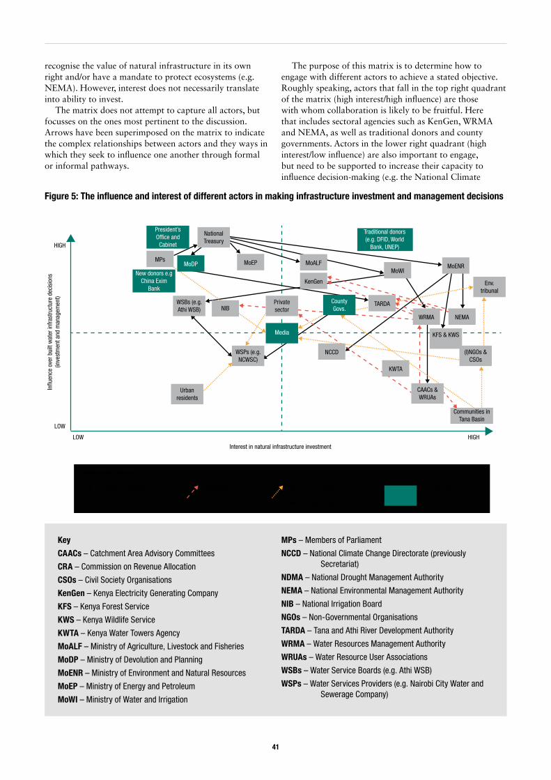
41
recognise the value of natural infrastructure in its own right and/or have a mandate to protect ecosystems (e.g. NEMA). However, interest does not necessarily translate into ability to invest.
The matrix does not attempt to capture all actors, but focusses on the ones most pertinent to the discussion. Arrows have been superimposed on the matrix to indicate the complex relationships between actors and they ways in which they seek to influence one another through formal or informal pathways.
The purpose of this matrix is to determine how to engage with different actors to achieve a stated objective. Roughly speaking, actors that fall in the top right quadrant of the matrix (high interest/high influence) are those with whom collaboration is likely to be fruitful. Here that includes sectoral agencies such as KenGen, WRMA and NEMA, as well as traditional donors and county governments. Actors in the lower right quadrant (high interest/low influence) are also important to engage, but need to be supported to increase their capacity to influence decision-making (e.g. the National Climate
Figure 5: The influence and interest of different actors in making infrastructure investment and management decisions
Interest in natural infrastructure investment
In�u
ence
ove
r bui
lt w
ater
infra
stru
ctur
e de
cisi
ons
(inve
stm
ent a
nd m
anag
emen
t)
LOW
LOW
HIGH
HIGH
Urban residents
WSPs (e.g. NCWSC)
WRC
VRA
NIB
CSOs
Media
WSBs (e.g. Athi WSB)
New donors e.g China Exim
Bank
MPs
President’s Of�ce and
Cabinet
MoDP
Private sector
National Treasury
MoEP
NCCD
County Govs.
KenGen
MoALF
Traditional donors (e.g. DFID, World
Bank, UNEP)
MoWIMoENR
WRMA NEMA
KFS & KWS
KWTA
CAACs & WRUAs
Communities in Tana Basin
(I)NGOs & CSOs
Env. tribunal
TARDATARDA
Pathways of in�uence
Planning & budgeting Regulation Other forms of in�uence (e.g. consultations, petitions, court cases)
Has in�uence on most other actors
Key
CAACs – Catchment Area Advisory Committees
CRA – Commission on Revenue Allocation
CSOs – Civil Society Organisations
KenGen – Kenya Electricity Generating Company
KFS – Kenya Forest Service
KWS – Kenya Wildlife Service
KWTA – Kenya Water Towers Agency
MoALF – Ministry of Agriculture, Livestock and Fisheries
MoDP – Ministry of Devolution and Planning
MoENR – Ministry of Environment and Natural Resources
MoEP – Ministry of Energy and Petroleum
MoWI – Ministry of Water and Irrigation
MPs – Members of Parliament
NCCD – National Climate Change Directorate (previously Secretariat)
NDMA – National Drought Management Authority
NEMA – National Environmental Management Authority
NIB – National Irrigation Board
NGOs – Non-Governmental Organisations
TARDA – Tana and Athi River Development Authority
WRMA – Water Resources Management Authority
WRUAs – Water Resource User Associations
WSBs – Water Service Boards (e.g. Athi WSB)
WSPs – Water Services Providers (e.g. Nairobi City Water and Sewerage Company)
42
Change Directorate, Water Resource User Associations, non-governmental and civil society organisations). Actors in the top left quadrant (e.g. national politicians, the Ministry of Energy and Petroleum, the National Treasury) have considerable influence over decision-making, but need to be persuaded or made aware of (in this instance) the importance of natural infrastructure investment. Actors in the bottom left quadrant (relatively low influence and interest) are simply kept informed.64
The remainder of this section elaborates on the interests that different actors have in natural infrastructure and the investments being made in the Tana Basin.
Natural infrastructure is not a commonly used term in Kenya; however, a number of actors have adopted the term ecosystem services65, which is used in key policies such as the Climate Change Act. Government institutions with a direct responsibility for investing in and protecting the natural environment include WRMA, NEMA, Kenya Forest Service (KFS), Kenya Wildlife Service (KWS) and Kenya Water Towers Agency (KWTA) (and arguably TARDA) and their respective Ministries and regional offices. There are also several donors and NGOs investing in catchment protection and conservation efforts. In the upper Tana, these include the IFAD-supported Upper Tana
64 Note that this is a subjective exercise, and the emphasis is on relative influence/interest. Arguably, NCWSC could be considered to have high interest as the company is investing in the Nairobi Water Fund.
65 Ecosystem services refer to benefits that societies and economies derive from ecosystems including but not limited to food and water supply, climate regulation, air purification, waste detoxification and assimilation, spiritual worship, recreation, etc (UNEP, 2009; Daily et al, 1997).
66 See: https://www.wetlands.org/casestudy/kenyas-tana-delta-maintaining-biodiversity-for-people-and-ecosystems/ (Accessed 23/07/17).
Natural Resource Management Project (USD 68 million; 2012-2020), which is a successor of the Mount Kenya East Pilot Project for Natural Resources Management (USD 25 million) (Interviews A7, D11 and F11), and the Nairobi Water Fund supported by The Nature Conservancy (TNC) (more below). There are also various initiatives in the Tana Delta supported by Wetlands International and partners.66 A key focus of such initiatives is improving rural incomes and livelihoods alongside conservation objectives. The Strategic Environmental Assessment (SEA) and Land Use Plan (LUP) for the Tana Delta (Box 9) are also important landmarks in protecting the delta ecosystems and communities.
On paper, non-environmental sectors such as energy and urban water supply are responsible for ensuring that their activities are environmentally and socially sustainable, to mitigate any potential negative impacts of their activities and, to an extent, invest in natural infrastructure (Interviews B1, B5, B13; see Table 4). For example, several interviewees stated:
‘Conservation of the whole basin to sustain river flows is a stated priority for NCWSC. We have a new environmental policy that promotes rainwater
Box 9: Land use planning in the Tana Delta
Following intense local resistance against land appropriation in the Tana Delta by private sector actors (GoK, 2013e), the government moved to carry out a Strategic Environment Assessment (SEA) for the Tana Delta area and to formulate a Land Use Plan (LUP). The process was led by an inter-ministerial (cross-sectoral) technical committee, supported by an advisory committee of stakeholder representatives. Extensive consultations were conducted at community, county (Lamu and Tana River counties) and national level, with inputs from international experts.
The SEA and LUP are viewed as instruments for improving delta communities’ resilience, giving the communities a voice in development decisions, and relieving tensions over land and water resources. In particular, the analyses within the SEA ‘were instrumental’ for interrogating different development and land use options in the delta, and formulating a strategy ‘that strikes the best balance between development and conservation’ (Odhengo et al., 2014a).
Although the SEA and LUP do not anticipate the impacts of new infrastructure upstream of the delta, such as the HGF Dam, they potentially provide a platform to input to decision-making around these projects.
‘The people in delta want to see more water but this depends on the health of the whole Tana catchment area. The LUP may be used to ignite debates on projects upstream such as High Grand Falls Dam.’ (Interview F11).
It has also been suggested that the SEA and LUP, as multistakeholder processes, could be extended to include other parts of the Tana Basin, although implementing the Tana Delta LUP remains the first priority in terms of resources.
Source: Odhengo et al. (2014a,b); Interviews F10 and F11
43
harvesting, tree planting, installation of rainwater harvesting tanks and so on.’ (Interview B1)
‘[KenGen’s] interest is to protect our investments and for environmental sustainability, making the lifespan of dams longer and reducing running costs.’ (Interview D12)
Given hydropower’s importance in its power generation mix, KenGen is financing conservation projects in major water towers, including the Nairobi Water Fund (NWF). Other notable NWF-contributors include NCWSC (protecting water supply to Nairobi), WRMA (concerned with basin water supplies and catchment protection) and TARDA (see TNC, 2015). Similarly, NIB has expressed concerns about soil and water quality deterioration and the impacts on irrigated production (Interview D6).
Certainly, decision-makers in key economic sectors are environmentally aware, although their interests tend to be confined to the impacts of specific environmental problems on their projects and investments. In other words, most investors in built infrastructure are concerned with the role that natural infrastructure plays in undermining (or supporting) built infrastructure.67 Several interviewees specifically mentioned the risks associated with catchment degradation, particularly the sedimentation of dams and reservoirs (e.g. Interviews A1, A2, B7, D6 and D7), but also the impacts on river flows. The nature and magnitude of these environmental risks, as well as whose responsibility it is to address them, remain contested (Interview A2) and the response tends to be reactive.
‘Until recently there was nothing of investment being put back into catchment protection, to ensure the longer life-span of the dams. It took us a lot of time to explain that these dams cannot sustain electricity generation with the sedimentation problem.’ (Interview D7)
Nevertheless, catchment degradation has become so severe in Kenya, that it has made it onto the political agenda (at least temporarily), leading to the establishment of the Kenya Water Towers Agency (KWTA).68
‘The problems surrounding the water towers became a political issue – the height of the debate being around 2009-10. These problems were affecting key sectors of the economy (hydropower, flower farms) and there were issues over land rights and deforestation.’ (Interview A9)
The Murang’a County Government has also vocalised the need to invest in catchment protection as part of
67 WISE-UP has classified this relationship between built infrastructure and natural infrastructure as Type 1 ecosystem services.
68 This was the result of pressure from community-based organisations, NGOs and the private sector (tea growers) among other actors (Interview A9).
69 In 2016/17, around 40 billion KES was allocated to the water sector in total. Of this, around 2 billion KES was allocated to water resources management. ‘The priorities are all wrong. We have argued about this in meetings but nothing is changing.’ (Interview F4)
70 Type 2 and Type 3 ecosystem services, respectively (in WISE-UP’s classification).
infrastructure development in the context of the NWCT. AWSB claims to be working with communities on catchment management using ‘a small portion of funds’, although this is not a legal requirement as the project doesn’t have a direct impact, and such activities are perceived to be KFS and WRMA’s mandate (Interview D2). More worryingly, however, is the claim that upstream environmental degradation (i.e. deforestation in the Abedares) is not really factored in to NWCT’s design (Interview C3, C8 and D2).
Catchment Management Strategies (CMS) are in place for major basins such as the Tana to, inter alia: monitor and manage water availability and demand; protect catchment areas; and deal with the impacts of floods and droughts (see WRMA, 2014). An element of these CMSs includes establishing information-sharing platforms for stakeholders (Interview D10). However, the extent to which such strategies are implemented in practice is questionable. Interviewees suggested that there was little funding available and consequently little action on the ground (Interviews B6, F4 and F5). Although it is difficult to put a set figure on natural infrastructure investments, one interviewee felt there were marked differences in Ministry of Water budget allocations between catchment management functions and building infrastructure for water services.69
The impact of built infrastructure on natural infrastructure, and the socio-economic value of natural infrastructure in its own right70, appear to feature less prominently in the decision-making of most politicians and other influential decision-makers, both at national and county level (Interviews A1, B2, B10, B13, B14, E10 and E13):
‘Wetlands are seen as wasteland, without uses. Hence there is an attitude that they should be converted to useful land use, such as irrigation.’ (Interview A1)
‘People who argue from Nairobi are seeing power, irrigation and GDP. They need to realise that consumption, investment, exports all rely on natural capital.’ (Interview E10)
‘The [Tana] delta is not really the Counties’ priority – it is key to talk about infrastructure. They are keen on aquaculture, beach walls, etc. You need to structure the agenda around these interests. They want to get money for infrastructure.’ (Interview E13)
44
A related challenge is that politicians and policy-makers do not always have a strong grasp of environmental concepts, such as ecosystem services or environmental flows (Interview B2, B6, D5, D11). Another is that ‘it can be difficult to get county governments to think beyond their own borders’, for example, incentivising investment in the upper catchments that will benefit downstream users (Interview D5; echoed in Interview D13).
Protecting nature for its own sake, and the importance of healthy ecosystems for local livelihoods, are more often highlighted by communities themselves, or by civil society organisation and NGOs with an interest in environmental conservation and/or social justice. However, this can have the disadvantage of pitting ‘conservation’ objectives against ‘development’.
‘In terms of discourses, the environment approach is perceived as anti-social or economic development, and vice versa.’ (WISE-UP Action Learning participant, March 2016)71
That said, the impacts of built infrastructure on downstream ecosystems do have to be considered with respect to the ESIA process to secure licences from NEMA and WRMA. Kenyan laws also require that a minimum baseflow is left to go downstream at any given point in the year to meet the needs of ecosystems and domestic water users (GoK, 2002; 2007b; 2016b). In fact, NWCT planners have accounted for downstream water demands up to 2030 (AWSB and GIBB International, 2014). Whilst there is less information available on the HGF, project proponents are emphasising this project’s benefits for downstream communities (TARDA, 2016).
Finally, the tensions and competition between different agencies working on environmental issues can be counterproductive, and perhaps indicate the institutional fragmentation described in section 3.2 (Interviews A3 and B1). For example, one interviewee noted the following dispute over jurisdictions in the upper Tana catchment:
‘Double gazettement of Mount Kenya as a forest reserve and as a national park has caused disputes over mandates. There are conflicts between KWS and KFS who have overlapping mandates. Mount Kenya is a forest but also a national park. To undertake projects in this area both agencies need an environmental license from NEMA. This creates tensions.’ (Interview B4)72
Another factor undermining coordinated approaches to investment in natural infrastructure may be the composition of environmental funding, which is often grant-based (Interview E7). Grant-based funding tends to be short-term and unsuitable for most environmental projects such as catchment reforestation or rehabilitation, which may take a long time (e.g. 10 years) to yield desired
71 The sentiment among civil society organisations that big infrastructure projects were ‘not their business’ came through strongly in this meeting, as did a reluctance to engage with government actors such as NIB or TARDA, who in the past have come into conflict with local communities.
72 Kenya Water Towers Agency (KWTA) can also be added to this mix.
results. On the other hand, there are indications that actors are willing to work collaboratively to tackle environmental problems where there is a shared common interest (Interviews B1, B4, B5, C19, D4, E4, and E6). As noted, several influential actors in the Tana Basin (e.g. KenGen and NCWSC) and a number of private companies are working together to establish the Nairobi Water Fund – the first of its kind in Kenya. This is a ‘public-private-people partnership’ aimed at mobilising resources for watershed management and ‘transforming the way business is done’ over the long term (Interviews B15, E9; TNC, 2015). One interviewee said NWF is ‘the best organised effort at scale, from a basin level view’ (Interview E7). It will be interesting to see, and scientifically document, what the NWF is able to achieve.
3.5. Accounting for climate change in investment decisionsActors differed in their views on the progress Kenya has made to date on climate change adaptation. Some of the earlier interviewees claimed that ‘climate change lacks government ownership and is not a key driver of decision-making’ (Interview A3) and the ‘leadership on climate change is very limited’ (Interviews A3 and A11). The Climate Change Secretariat (before being upgraded to Directorate under the Climate Change Act) appeared to lack the legal mandate to leverage other line ministries or government agencies effectively. There has also been a high turnover of sector representatives on the committees leading planning processes, making it hard to launch or sustain a coordinated programme of action (Interview A6). These factors, coupled with a lack of dedicated lines in sector budgets, have meant few of the actions identified in the NCCAP have been implemented (Interviews A3 and F9). There were also concerns that the formal climate change planning process had not been a powerful influence over socio-economic policies or sector decisions, favouring more pressing concerns:
‘They are very interested in energy, as per Vision 2030, and are responding to that need, but not due to climate change, although there may be synergies. Energy will drive industrialisation. They are considering investment in geothermal and hydropower and other ‘clean’ energy.’ (Interview A3)
These sentiments were echoed in a more recent interview:
‘Mainstreaming [of climate change] should be done through the Medium Term Plans for Vision 2030. Lots of money has been spent on this, but I saw
45
little evidence of this [in the recent MTP planning process]. Few people were justifying projects in terms of climate change. We need to be clear what mainstreaming is. The current MTP guidelines don’t say anything about climate change.’ (Interview F9)
However, the institutional context is evolving rapidly with the implementation of the Climate Change Act (2016), and both mitigation and adaptation are increasingly a priority for decision-makers. Most progress to date has been made with respect to mitigation; for example, a working group has been established to implement Kenya’s Intended National Determined Contribution (INDC) (see MENR, 2015). Adaptation has lagged behind in terms of coordinated action; however, several important initiatives are underway, including the National Adaptation Plan (Interviews F1 and F9) and various donor-supported initiatives (discussed below).
As discussed in section 2.1 of this report, the Climate Change Act provides for the establishment of various high-level institutions with a legal mandate to mainstream climate change into planning processes – namely the Climate Change Council and Directorate – as well as defining responsibilities at lower levels of government. The Climate Change Secretariat has subsequently been upgraded to a Directorate, theoretically wielding greater authority over other actors, and has already had its capacity enhanced in terms of staffing and expertise (although finance remains a limitation – Interview F9). The legislation also contains provisions for county-level action.
‘The Climate Change Bill gives county governments representation on the Climate Change Council and with respect to the climate fund. It anchors information sharing and capacity building for counties for climate resilience and mitigation.’ (Interview D13)
The Treasury will also be represented on the Council (once it convenes) and is already actively engaged in the climate change agenda, playing an important role in sectoral planning and financial allocations (Interviews D11) and leading on proposals for international climate finance (Interviews F6 and F11). In future, not only does climate change have to be factored into budget planning processes and assessing staff performance, but securing financial resources to implement the Act will be imperative (Interviews 3 and E15). It was felt donors had a key role to play in this regard (Interviews E7, E12 and F9). USAID, World Bank and DFID, to name a few, are already providing significant technical (and other) support to key institutions, such as the Climate Change Directorate, and reform processes (see Table 8 below).
At a practical level, there are indications that climate risks and mitigation strategies are being accounted for,
73 McGuire (2017) discusses WRUAs as a potential entry-point for supporting climate adaptation from the bottom-up, albeit recognising that WRUA capacities vary. WRUA’s are responsible for developing sub-catchment management plans and are supported by WRMA to identify location-specific challenges and responses, which may include climate change-related issues such as water scarcity or flooding, or investments in protecting natural infrastructure. WRUAs receive some funding through the Water Services Trust Fund (WSTF) but are also permitted to access other funding streams, which could include climate finance.
to some extent, in planning processes. For example, the Tana Catchment Management Strategy recognises the risks posed by declining groundwater levels, changing river flow regimes, floods and droughts, and identifies measures to address these such as increasing water storage (although the details are vague) (Interviews B8 and E14; WRMA, 2014).73 Notably, the National Water Master Plan accounts for climate change in its projections of water availability and demand to 2030. For example, updates to the NWMP in 2013 scale down ambitions for irrigation expansion to more realistic targets (WRMA, 2013c). The Tana Delta LUP and SEA also discuss climate change risks, for example the impacts of saline intrusion (Odhengo et al., 2014a,b). Meanwhile, NEMA is revising environmental regulations to mainstream climate change into the environmental and social impact assessment process (Interviews F13 and F14).
There are also indications that climate change is being considered in the design of new water infrastructure projects (Interview E14), although it is difficult to confirm whether this is ‘the norm’. Big infrastructure such as the NWCT and HGF dam are designed to have a long lifespan of 50 or even 100 years; factoring in climatic changes is thus important to ensure the viability of such investments. Moreover, this is mandatory as part of the ESIA process (Interview D6), although ‘the reviewers may not always be up to speed’ (Interview E1). TARDA claims to be ‘using a climate change model in the design’ of the High Grand Falls project (Interview D9; see also Egis BCEOM and GoK, 2010), yet there is no mention of climate risks in the preliminary ESIA report (TARDA, 2016). The ESIA for the NWCT similarly contains little discussion of climate change (AWSB and GIBB International, 2014), but AWSB claims they attempted to factor climate risks into the feasibility study.
‘In the feasibility studies we try to account for climate variation, but it is difficult. As a concept climate change is under development and the science is still evolving. We tried to ask the consultants to include climate change, but this request was not really addressed.’ (Interview D2)
As this interviewee indicates, even if technical experts have the skills to use available climate information, they suffer from a lack of data on which to project future changes in rainfall and river flows (Parry et al, 2012; Case, 2006). There are considerable uncertainties on the direction and magnitude of change in Kenya, as well as the relative effects of changes in rainfall versus other processes, such as catchment degradation (Parry et al, 2012).
In the power sector, there is rising concern about climate change’s impacts on hydropower generation and storage capacities (Interviews B5 and F7). Hydropower is sensitive to climate variability. Droughts can cause low water levels in reservoirs, while floods contribute to the
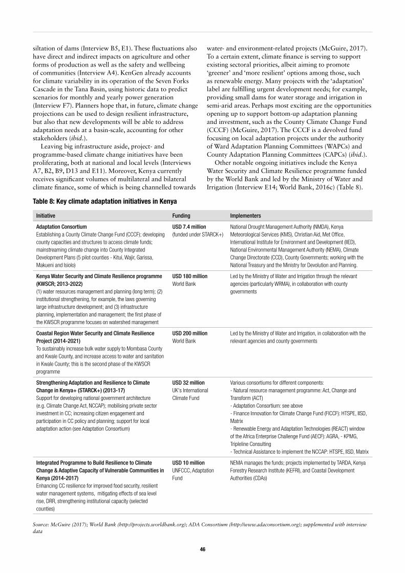
46
siltation of dams (Interview B5, E1). These fluctuations also have direct and indirect impacts on agriculture and other forms of production as well as the safety and wellbeing of communities (Interview A4). KenGen already accounts for climate variability in its operation of the Seven Forks Cascade in the Tana Basin, using historic data to predict scenarios for monthly and yearly power generation (Interview F7). Planners hope that, in future, climate change projections can be used to design resilient infrastructure, but also that new developments will be able to address adaptation needs at a basin-scale, accounting for other stakeholders (ibid.).
Leaving big infrastructure aside, project- and programme-based climate change initiatives have been proliferating, both at national and local levels (Interviews A7, B2, B9, D13 and E11). Moreover, Kenya currently receives significant volumes of multilateral and bilateral climate finance, some of which is being channelled towards
water- and environment-related projects (McGuire, 2017). To a certain extent, climate finance is serving to support existing sectoral priorities, albeit aiming to promote ‘greener’ and ‘more resilient’ options among those, such as renewable energy. Many projects with the ‘adaptation’ label are fulfilling urgent development needs; for example, providing small dams for water storage and irrigation in semi-arid areas. Perhaps most exciting are the opportunities opening up to support bottom-up adaptation planning and investment, such as the County Climate Change Fund (CCCF) (McGuire, 2017). The CCCF is a devolved fund focusing on local adaptation projects under the authority of Ward Adaptation Planning Committees (WAPCs) and County Adaptation Planning Committees (CAPCs) (ibid.).
Other notable ongoing initiatives include the Kenya Water Security and Climate Resilience programme funded by the World Bank and led by the Ministry of Water and Irrigation (Interview E14; World Bank, 2016c) (Table 8).
Initiative Funding Implementers
Adaptation ConsortiumEstablishing a County Climate Change Fund (CCCF); developing county capacities and structures to access climate funds; mainstreaming climate change into County Integrated Development Plans (5 pilot counties - Kitui, Wajir, Garissa, Makueni and Isiolo)
USD 7.4 million(funded under STARCK+)
National Drought Management Authority (NMDA), Kenya Meteorological Services (KMS), Christian Aid, Met Office, International Institute for Environment and Development (IIED), National Environmental Management Authority (NEMA), Climate Change Directorate (CCD), County Governments; working with the National Treasury and the Ministry for Devolution and Planning.
Kenya Water Security and Climate Resilience programme (KWSCR; 2013-2022) (1) water resources management and planning (long term); (2) institutional strengthening, for example, the laws governing large infrastructure development; and (3) infrastructure planning, implementation and management; the first phase of the KWSCR programme focuses on watershed management
USD 180 million World Bank
Led by the Ministry of Water and Irrigation through the relevant agencies (particularly WRMA), in collaboration with county governments
Coastal Region Water Security and Climate Resilience Project (2014-2021) To sustainably increase bulk water supply to Mombasa County and Kwale County, and increase access to water and sanitation in Kwale County; this is the second phase of the KWSCR programme
USD 200 millionWorld Bank
Led by the Ministry of Water and Irrigation, in collaboration with the relevant agencies and county governments
Strengthening Adaptation and Resilience to Climate Change in Kenya+ (STARCK+) (2013-17)Support for developing national government architecture (e.g. Climate Change Act, NCCAP); mobilising private sector investment in CC; increasing citizen engagement and participation in CC policy and planning; support for local adaptation action (see Adaptation Consortium)
USD 32 millionUK's International Climate Fund
Various consortiums for different components:- Natural resource management programme: Act, Change and Transform (ACT)- Adaptation Consortium: see above- Finance Innovation for Climate Change Fund (FICCF): HTSPE, IISD, Matrix- Renewable Energy and Adaptation Technologies (REACT) window of the Africa Enterprise Challenge Fund (AECF): AGRA, - KPMG, Tripleline Consulting- Technical Assistance to implement the NCCAP: HTSPE, IISD, Matrix
Integrated Programme to Build Resilience to Climate Change & Adaptive Capacity of Vulnerable Communities in Kenya (2014-2017)Enhancing CC resilience for improved food security, resilient water management systems, mitigating effects of sea level rise, DRR, strengthening institutional capacity (selected counties)
USD 10 millionUNFCCC, Adaptation Fund
NEMA manages the funds; projects implemented by TARDA, Kenya Forestry Research Institute (KEFRI), and Coastal Development Authorities (CDAs)
Table 8: Key climate adaptation initiatives in Kenya
Source: McGuire (2017); World Bank (http://projects.worldbank.org); ADA Consortium (http://www.adaconsortium.org); supplemented with interview data

47
The current phase of the KWSCRP, which closes in 2022, is focusing on watershed management plans within six different basins including the Tana (McGuire, 2017). The second phase targets water security and resilience in the coastal region, and there are speculations that a third phase could support implementation of the abovementioned management plan for the Tana Basin (ibid.). Investments in conservation are also being made with support from the Global Environmental Facility (GEF), including in the Tana
Basin. For example, in the past, GEF has supported the Tana River National Primate Reserve Conservation Project (lower Tana), the Mount Kenya East Pilot Project for Natural Resource Management (upper Tana) and start-up of the Nairobi Water Fund (upper Tana) (McGuire, 2017). It is hoped further funding can be secured from the GEF or Green Climate Fund to support implementation of the Tana Delta Land Use Plan (Interview F11).
48
4. Conclusions and recommendations
This report has set out the findings of a political economy analysis of water infrastructure investments in the Tana Basin, Kenya, exploring the structural factors and actor decision-logics that have shaped decision-making. In particular, the analysis has drawn on two case studies: an inter-basin transfer from the upper Tana to Nairobi City known as the Northern Water Collector Tunnel (NWCT) project (under development); and a planned multipurpose dam known as High Grand Falls (HGF Dam) for which funds are yet to be secured. Both are politically contentious infrastructure projects in the Tana Basin. The purpose of the analysis is not only to understand decision-making dynamics around such investments, but also to identify entry points to support integrated, climate-resilient approaches to river basin development. To this end, the conclusions highlight key opportunities (and challenges) in promoting mixed portfolios of built and natural infrastructure, and provide recommendations for action.
4.1. Key findings
4.1.1. Water governance is highly fragmented, hindering strategic basin-level planning. There are currently few fora in which stakeholders can explore alternative portfolios of built and natural infrastruc-ture or negotiate trade-offs, particularly at a basin level. Our research has found that laws and policies for water-related sectors are often inconsistent and institutional mandates overlap. This leads to conflicts of interest and competition for the resources meant for water infrastructure investment. Sector siloes are strong and deep-seated rivalries exist between different ministries and agencies, hindering cross-sectoral cooperation and collaboration. Leadership on integrated basin development is unclear, and no single institution or agency seems to have the requisite political clout and capacity to do so at present. Meanwhile, counties are formulating their own laws and establishing their own structures for resource management, adding a further layer of complexity to the institutional and political landscape. Another issue is that mechanisms for joint planning at basin-level appear to be absent and there is no obvious forum in which different
sectors and stakeholders can strategically discuss options and negotiate trade-offs.
Despite these challenges, there have been some notable success stories at a sub-basin or programme level, such as the Nairobi Water Fund (NWF) and Tana Delta Land Use Plan (LUP). These processes could be learnt from and perhaps built on. The LUP has been particularly successful in supporting bottom-up planning and fostering a sense of ownership among county-level stakeholders and national agencies alike. The NWF has taken a somewhat different approach, leveraging significant financial commitments from powerful actors (including the private sector) to invest in natural infrastructure at the local level.
4.1.2. Developing big water infrastructure is con-sidered a national priority in Kenya, which can make it difficult politically to discuss alternatives or to contest projects. However, accountability and ad-herence to environmental regulations are improving thanks to the framework set by the new Constitution and other legal reforms.
As a country, Kenya wants to grow its economy to achieve aspirations of Vision 2030 and strengthen its middle-income status. Built water infrastructure investment is viewed as a key part of medium-term investment plans, and critical in tackling the challenges posed by rapid population growth and climate change. Kenya has a number of urgent development needs that directly depend on the ability to capture, store and transfer water. However, there is a risk that short-term priorities override considerations of longer-term needs and hence foreclose other options (such as investments in natural infrastructure).
There are several big projects planned for the Tana Basin with high political stakes, such as the HGF Dam and NWCT. As ‘concrete’ symbols of progress, power and national pride built infrastructure projects are attractive to politicians, and often given high profile in pledges to the electorate. This can make it very difficult for stakeholders to contest such projects. In contrast, investments in natural infrastructure tend to be less attractive politically, despite offering substantial ecological and socio-economic benefits. This is partly because investments such as catchment protection are less visible, but also because their socio-economic impacts are difficult to prove. There is thus a
49
need to strengthen the evidence base to make the case for natural infrastructure.
Given the high stakes involved, there is a risk that political interests push projects forward despite technical concerns, or without following due process. At worst, this can close down the formal (public) spaces in which stakeholders can discuss development options and negotiate the distribution of risks and benefits from new investments. In this regard, regulatory agencies have an important role to play in enforcing the provisions provided by the Constitution and environmental laws; for example, ensuring the quality of public consultation and ESIAs. Whilst accountability is improving, regulatory agencies could be strengthened further – technically and politically – so that they can effectively hold powerful decision-makers to account through better planning procedures.
4.1.3. Water governance arrangements are changing following the 2010 Constitution and revised Water Act (2016); devolution has created new opportunities for local actors to influence water infrastructure decisions.As noted above, water governance arrangements are changing following the 2010 Constitution and 2016 Water Act.74 Substantial functions, responsibilities and resources have been transferred from central government to the newly created county governments, including for water service delivery. The process of devolution has also created new opportunities for local actors to influence (and contest) the decisions made around centrally led water infrastructure development.
Counties are eager to claim their place and space in water governance processes. Water has become a major issue in county politics and there is a strong incentive for county politicians to be seen protecting local interests and securing benefits for their constituencies. Thus, top-down planning by national agencies (typical of big infrastructure projects in the past) has increasingly been challenged by county politicians demanding that local (and not just national) needs are addressed. Such contestations are likely to determine the direction of water planning approaches and shape future spaces for water governance processes in basins like the Tana.
More generally, there appears to be an increasing emphasis on sharing benefits from the exploitation of natural resources, particularly ensuring that communities and counties receive a fair share of any profits. Counties are beginning to assert their rights in this regard, as per the Constitution. New resource-sharing laws (currently in parliament for approval) will, if passed, also influence how benefit-sharing arrangements play out at national and county levels and guide the nature of contestations in future.
74 As discussed in Chapter 3.2, revisions to the Water Act in 2016 seek to align water governance with the Constitution and to resolve some ambiguities regarding the division of responsibility between national and county government, including for infrastructure development and management. However, tensions remain regarding the role of the Water Services Boards and the new Act was initially disputed by counties in court.
4.1.4. Actors use three main strategies to promote or contest water infrastructure projects: control of data and information, use of the media and recourse to the law.
Data are collected by several government entities but the mechanisms to share and validate data are generally weak (or non-existent). Different institutions hold different data sets and stake their claims on this basis. Information may also be intentionally withheld from the public domain due to political sensitivities (as in the case of the HGF Dam). Stakeholders without access to this information find it difficult to assess or counter claims, and this makes it difficult for them to engage in debates regarding a project’s feasibility and its potential impacts (positive and negative) on different groups.
In the case of the NWCT project, both pro-project and anti-project stakeholders have sought to use the media to influence decision-making and public opinion to their own advantage. For example, county- and national-level politicians have drawn attention to perceived inadequacies in the environmental and social impacts assessment (ESIA) process, demanding further consultations and feasibility studies. The media has also been deployed as a vehicle to generate political controversy around the project, particularly in the run-up to elections. The ‘heat’ generated by these debates has served to put project proponents and regulatory authorities under pressure to heed stakeholder demands, and arguably led to the decision to hold additional stakeholder consultation meetings prior to project implementation.
As indicated in point 2, constitutional requirements for public consultation do not always result in meaningful stakeholder engagement and can be manipulated (or are simply inadequate). The issue of stakeholder participation in ESIAs has increasingly become a point of leverage for county governments vis-a-vis national government agencies, as the NWCT case nicely demonstrates. However, where dialogue fails, formal (legal) processes are also available to hold project proponents to account, such as recourse to the Environmental Tribunal to challenge an environmental licence. This allows stakeholders to raise concerns that certain mandatory decision processes have not been adhered and forces parties to reach an agreement before the project proceeds.
4.1.5. Natural infrastructure is recognised as impor-tant for socio-economic development, but remains secondary to built infrastructure in terms of political interest and public investment.
The environment is recognised as a key pillar in national policy (Vision 2030), but is often perceived as secondary to, or in conflict with, the goal of socio-economic development. For instance, investments in built infrastructure to supply electricity or water appear to take
50
precedence over investments in catchment conservation, because energy and water supply are key priorities in national development. Although environmental concepts such as ‘ecosystem services’ are referenced in policy documents, their significance for social and economic development is not always fully understood by decision-makers (or indeed practitioners). On one hand, therefore, politicians want built water infrastructure projects to deliver direct benefits to constituents, while on the other hand, they may know little about the benefits of natural infrastructure. The problem is exacerbated where technical advisors have similar knowledge gaps.
There is perhaps more interest (and action) where investments in natural infrastructure are perceived to be necessary for the sustainability of built infrastructure. For example, considerable funding is going into catchment protection in the upper Tana through the Nairobi Water Fund, in order to protect the hydropower dams and other facilities (this is largely private and donor money, rather than from the public purse). This interest is sustained by perceptions that benefits will accrue to influential stakeholders in the upper basin, such as the Kenya Electricity Generating Company (KenGen) and Nairobi City Water and Sewerage Company (NCWSC), as well as boosting these companies’ public images. For built infrastructure to support sustainability in the lower basin, improved upstream-downstream coordination will be necessary.
In project design, there are requirements to consider downstream needs, securing environmental flows and water for other users. Evidence from our case studies suggests these are factored in, although much depends on how the infrastructure is subsequently managed. For example, it is unclear how the HGF Dam will affect implementation of the Tana Delta LUP. Management of the current and planned hydropower dams is a key determinant of the wellbeing of downstream ecosystems and communities. At present, these dams are largely operated to meet energy production targets, with limited consideration of other water users.
4.1.6. There has been significant progress in establishing the legal and institutional framework to address climate change in Kenya; further work needs to be done to put this into practice, and to mainstream climate change into routine planning and budgeting.The Climate Change Act, passed in 2016, provides an exciting opportunity to strengthen national institutions for strategic planning, and provides a framework to mainstream climate adaptation and mitigation into sectoral (and county) planning and budgeting processes. Moreover, mechanisms are now in place to enable Kenya to apply for and manage international climate finance. Development partners are also providing significant technical and financial support to operationalise climate change policies and develop strategies.
At national level, mainstreaming climate risks into routine planning and budgeting is still in its infancy, and tends to be sidelined by sectoral concerns that are perceived as more pressing. Most progress has been made with mitigation; adaptation planning has lagged behind and tends to be viewed as an ‘add-on’ to existing activities. That said, units are being set up in key ministries (including water) to facilitate mainstreaming, and a small number of counties are piloting integrating climate change concerns into their development plans, with assistance from development partners. Climate risks are being addressed, to an extent, in water infrastructure planning and design, as well as in catchment management, although technical capacity needs to be built.
4.2. Recommendations for policy-makers
4.2.1. To enable strategic basin-level planning, mechanisms (or forums) for cross-sector collabora-tion are needed, as well as clear leadership from the top.
Strategic planning, with all key players around the table, is important to ensure that viable options for long-term basin development are identified and that potential trade-offs can be discussed transparently (rather than each sector doing its own thing). Given the sectoral divisions, leadership needs to come from the top – the Office of the President, cabinet ministers and the Council of Governors, among other senior decision-makers. In addition to planning future investments, dialogue will be crucial in coordinating the management of the cascade of dams in the Tana Basin, which control the river flow regimes and thus any benefits derived from it.
Based on our findings, a first step to strengthen strategic planning might be to establish an inter-ministerial committee (or similar body). This committee’s task would be to assess options for improving strategic planning and identify the best way forward. Such a committee should be designed to minimise staff turnover (to build institutional memory and capacity) and would need a clear mandate and strong leadership to ensure real progress can be made. For the Tana Basin, there may also be opportunities to strengthen existing multistakeholder platforms or initiatives, such as the Nairobi Water Fund or Tana Delta LUP, to promote investments in natural infrastructure and encourage cross-sectoral collaboration.
4.2.2. A mindset change and re-organisation of government institutions may be required to achieve Vision 2030 and implement the Kenyan Constitution’s provisions.Significant progress has been made in reforming the water sector since the early 2000s. However, many institutions with a stake in water resource management and development, such as TARDA or KenGen, lie outside this process. Given the current overlaps in mandates, lack

51
of integration and rivalries between government agencies, several interviewees argued that existing institutions needed to be restructured. More fundamentally, the Constitution calls for a change in mindsets to bring services and other benefits to the Kenyan people. This means putting narrow political interests aside (i.e. discarding the ‘empire’ mentality) and working with citizens to improve their social and economic wellbeing, protect the environment, and build resilience to climate change. Vision 2030’s goals can only be achieved through decision-making processes and institutions that assess and choose between different water investment options objectively, weighing up and managing trade-offs between different sectors and communities’ demands.
4.2.3. Counties need to be involved in making strategic decisions for basin-wide development, and not only in project-based consultations.As described, counties of the Tana Basin are increasingly asserting their authority vis-à-vis large infrastructure projects. They also need to be included in strategic planning processes through, for example, the Council of Governors or regional county blocks. Counties may also benefit from having their own basin-level fora, bringing together different stakeholders to build consensus around common concerns, and negotiating upstream-downstream water needs. Given the diverse interests involved, and tensions between counties over resources, a step-wise dialogue-based approach is advisable. The facilitator will need to be carefully chosen to maintain neutrality.
4.2.4. Both natural and built infrastructure can play a role in supporting resilient river basin devel-opment; putting in place mechanisms that ensure climate risks are factored into routine planning and budgeting is a priority.Mainstreaming climate resilience into basin planning (and vice versa) is in its infancy, not only in Kenya, but around the world. An important step towards achieving this is to put in place mechanisms that ensure climate risks are addressed in routine planning and budgeting. This includes the Vision 2030 Medium Term Plans, as well as project design and management (e.g. to build flexibility into the system). This directive is in the new Climate Change Act and urgently needs to be put into practice. Moreover, adaptation planning has lagged behind mitigation efforts to date, and needs to be given greater attention (and resources) at a strategic level. The Climate Change Council and Directorate clearly have an important role in leading these processes, but commitment is also required from sectoral ministries and agencies.
Integrated cross-sectoral approaches will be important to optimise the use of both natural and built infrastructure for climate adaptation and mitigation. The tools WISE-UP
75 WISE-UP has a real opportunity to build on the connections forged through the Action Learning workshops with influential basin players, focussing on individuals from key agencies who can act as pioneers and champions in their own institutions. Other forums to tap into, at a high level, would be cabinet meetings (for example, drafting a memorandum) and the new Climate Change Council.
has developed can be used to make trade-offs explicit and demonstrate the (economic, social and environmental) value of considering portfolios of built and natural infrastructure for climate adaptation. These can be tailored to address specific problems that decision-makers face at a strategic level or for specific projects or programmes, and consider their impacts on the rest of the basin.
4.3. Recommendations for development partners
4.3.1. The case needs to be made to policy-makers for viable alternatives to ‘business as usual’ in river basin development, particularly given future climate change. In light of Vision 2030 ambitions, this evidence is likely to be well-received.Political interest in water infrastructure as a means to achieving other socio-economic goals (e.g. energy and food security), suggests that the evidence projects such as WISE-UP provide to inform decision-making would be welcomed. Results from modelling studies and other research can help demonstrate to policy-makers (such as cabinet ministers) why alternatives to ‘business as usual’ need to be considered, and what these might look like. Key findings from this research should be used to engage decision-makers using existing networks and forums, aiming to influence influential stakeholders as well as inform the work of staff in key government agencies such as TARDA, KenGen, WRMA and NEMA.75 Working with the Council of Governors would be a good starting point to disseminate findings to county governments through, for example, the Environment and Natural Resources Management Committees of the County Assemblies.
As WISE-UP’s experience has shown, ownership of results can be built by involving decision-makers in the research process. However, it is also crucial to tailor the research to meet policy-makers and planners’ needs, incorporating the research process in ‘real life’ decision-making processes to ensure the relevance to the problems they face. This would be an important next step for the project now that stakeholders are familiar with the tools available.
4.3.2. Support to regulatory authorities, civil society organisations and other local platforms to ensure that the Constitution’s provisions are enforced and decision-makers held to account (countering undue political influence).
The 2010 Constitution and new county system opens up possibilities for stronger public participation and consultation processes for water infrastructure development. In this, the National Environment
52
Management Authority (NEMA) and Water Resource Management Authority (WRMA) need to play a key role. Working closely with these agencies and building their capacities will be important to ensure they are able to assess plans and projects based on the available information, including climate change. Capacity needs relate to financial and human resources, as well as technical skills, training, information/data, and networking
County governments and civil society groups also have an important role to play in representing local interests in water infrastructure decision-making, engaging in strategic planning and ensuring that ESIA consultation processes are adequate. Giving these actors evidence of infrastructure options and impacts could help to inform their positions vis-à-vis current basin development priorities. Moreover, encouraging environmental organisations to engage with influential players (socio-economic interests) and demonstrating its value, may help to avoid an ‘environment versus development’ mentality. As noted above, for the Tana Basin there may be opportunities to strengthen existing multistakeholder initiatives. Resources are needed for implementing the Tana Delta LUP, for example. It has also been suggested that this land-use planning process could be extended to encompass other parts of the Tana Basin. Other fora through which to engage and disseminate research findings include the Kenya Wetlands Forum and active Water User Associations in the Tana Basin.
4.3.3. Providing tailored technical and financial assistance to the Climate Change Council and Directorate, Treasury, sectoral agencies, and County Governments, will be essential to mainstream climate adaptation and mitigation.Development partners are already supporting the establishment of new institutional structures for action on climate change, provided for by the Climate Change Act. A big opportunity in promoting natural infrastructure as an adaptation option lies in working with Climate Change Directorate and Council. There is ample scope to provide
technical and financial assistance to these institutions to build their capacity and evidence-base for decision-making, and make the case for investments in both built and natural infrastructure. Current entry points include the implementation of the National Adaptation Plan, National Climate Change Action Plan (with revisions) and Green Economy Strategy. The Council, in particular, has the potential to be an influential platform, given the high-level (ministerial) representatives involved.
At a sectoral or thematic level, there are opportunities to work with working groups (e.g. on clean energy) and the new climate desks/committees (e.g. Ministry of Water and Irrigation, or Ministry of Energy and Petroleum), supporting the technical staff who are responsible for mainstreaming climate change actions. In a similar vein, it will be important to engage with the agencies responsible for planning and designing infrastructure investments, such as WRMA, TARDA and KenGen.
Counties are currently formulating (or already have) their own laws and development plans, which presents an opportunity to ensure that both natural infrastructure investments and climate change are on the agenda. Some counties are piloting the mainstreaming of climate change into their planning processes, with support from development partners (the Adaptation Consortium). There are likely to be opportunities to support the upscaling of such initiatives in future.
Finally, the proliferation of climate finance is diversifying the funding instruments available for river basin investments, including supporting environmental sustainability and bottom-up adaptation. The National Treasury (as the National Designated Authority) is currently leading on several proposals to access funds from the Global Environmental Facility (GEF), Green Climate Fund (GCF) and other sources, and is leading on the development of a National Climate Change Fund (NCCF). To this end, the evidence such projects as WISE-UP generate will be important in demonstrating the need to ‘climate-proof’ investments and in understanding the role that natural infrastructure plays in building resilience.
53
References
Acres International Limited (1987) National Energy Development Plan of Kenya 1986-2006. Report for UNDP, World Bank and Ministry of Energy and Regional Development. Nairobi, Kenya.
Alexander Gibbs and Partners (1959) Upper Tana Catchment Water Resources Survey, 1958-59. Nairobi, Kenya: Alexander Gibbs and Partners Africa.
Adams, W.M. (1992) Wasting the rain: Rivers, people, and planning in Africa. London: Earthscan.AFD (2013) Nairobi Northern Collector: Extension of Nairobi drinking water system. Agence Française de Dévelopment
(AFD), France. Available from: http://www.afd.fr/webdav/shared/PORTAILS/PAYS/KENYA/Nairobi%20Northern%20Collector%20VO.pdf
Andae, G. (2016) More acres put under maize in Galana farm ahead of July launch, Daily Nation, Tuesday June 7 2016. Available from: http://www.nation.co.ke/business/seedsofgold/More-acres-for-maize-in-Galana-Kulalu-irrigation-project/2301238-3236164-oqw7s5/index.html
Auerbach, D.A., Deisenroth, D.B., McShane, R.R., McCluney, K.E. and Poff, N.L. (2014) ‘Beyond concrete: accounting for ecosystem services from free-flowing rivers’, Ecosystem Services 10: 1-5.
AWSB (2016a) The Northern Water Collector Tunnel Phase 1 Project. AWSB Booklet, Ministry of Water and Irrigation, Government of the Republic of Kenya, Nairobi. Available from: http://awsboard.go.ke/wp-content/uploads/2016/01/NCT-Commissioning-booklet_05.pdf
AWSB (2016b) http://awsboard.go.ke/about/ Accessed 04/10/16AWSB (2016c) Feasibility Study and Master Plan for Developing New Water Sources for Nairobi and Satellite Towns.
Northern Water Collector Tunnel Phase 1: Hydrological Assessment Report. Nairobi: AWSB.AWSB (2015) ‘Kenya’s biggest water project: the Northern Water Collector Tunnel, Frequently asked questions’. Athi
Water Services Board, Ministry of Water and Irrigation, Government of the Republic of Kenya, Nairobi. Available from: http://awsboard.go.ke/wp-content/uploads/2015/05/FAQs-Advert_001.pdf
AWSB and GIBB International (2014) Environmental and Social Impact Assessment for Northern Collector Tunnel Phase 1: Final Study Report. Athi Water Services Board (AWSB), Ministry of Water and Irrigation, Government of the Republic of Kenya, and GIBB International.
AWSB (2012) Feasibility Study and Master Plan for Developing New Water Sources for Nairobi and Satellite Towns. Volume 1: Master Plan Main Report. Nairobi: AWSB
AWSB (2011) Feasibility Study and Master Plan for Developing New Water Sources for Nairobi and Satellite Towns: Preliminary EIA for the Selected Scenario: Nairobi Water Sources, Phases 1 & 2, Version 03, Athi Water Services Board, Ministry of Water and Irrigation, Government of the Republic of Kenya, Nairobi.
Baker, T., Kiptala, J., Olaka, L., Oates, N., Hussain, A. and McCartney, M. (2015) Baseline review and ecosystem services assessment of the Tana River Basin, Kenya. IWMI Working Paper 165. Colombo, Sri Lanka: International Water Management Institute (IWMI). 107p. doi: 10.5337/2015.223.
Barber, M. and Grainne, R. (eds.) (1993) Damming the Three Gorges. What dam builders don’t want you to know. London, UK: Earthscan.
Booth, D. (2015) Development as a collective action problem: Addressing the real challenges of African governance. Synthesis report of the Africa Power and Politics Programme. London: Overseas Development Institute.
Booth, D., Cooksey, B., Golooba-Mutebi, F. and Kanyinga, K. (2014) East African prospects: An update on the political economy of Kenya, Rwanda, Tanzania and Uganda. London, UK: ODI
Booth, D. and Golooba-Mutebi, F. (2009) Aiding Economic Growth in Africa: The Political Economy of Roads Reform in Uganda. ODI Working Paper 307, London: Overseas Development Institute.
Buluma, G. (2014) Al-Shabaab: The Threat to Kenya and the Horn of Africa. Research project paper submitted in partial fulfillment of the requirements of the Master of Strategic Studies Degree, U.S. Army War College, Carlisle, AP.
Burke, J. (2016) Kenyan police in fresh clashes with political activists, The Guardian, Monday 23 May 2016. Available at: https://www.theguardian.com/world/2016/may/23/kenyan-police-in-fresh-clashes-with-political-activists
Biswas, A.K. (2004) ‘Dams: cornucopia or disaster?’ International Journal of Water Resources Development 20(1):3-14.Biswas, A.K. and Tortajada, C. (2001) ‘Development and Large Dams: A Global Perspective’. International Journal of
Water Resources Development 17(1): 9-21.Bryant, B.P. (2015) Ecosystem Services Assessment and Valuation of Proposed Investments for the Upper Tana-Nairobi
Water Fund: A Technical Appendix to the Upper Tana-Nairobi Water Fund Business Case. The Natural Capital Project, Stanford University.
Cabral, A. (1998) ‘National Liberation and Culture’. In: Emmanuel Chukwudi Eze, (ed.), African Philosophy: An Anthology. London: Blackwell, 260-266pp.
54
CADP (1991) Tana River Wetlands Survey. Coast ASAL Development Programme (CADP), Ministry for the Reclamation and Development of Arid and Semi-Arid Lands and Water Resources, Mombasa.
Cannon, B.J. (2016) Unique Challenges face the Galana-Kulalu Irrigation Scheme, Kenya Engineer, Friday, 27 May 2016. http://www.kenyaengineer.co.ke/dev/index.php/features/item/2113-unique-challenges-face-the-galana-kulalu-irrigation-scheme
Cannon, J.R. (2016) ‘Terrorists, Geopolitics and Kenya’s Proposed Border Wall with Somalia’. Journal of Terrorism Research 7(2): 22-36.
Carr, G. (2015) ‘Stakeholder and public participation in river basin management: an introduction’. Wiley Interdisciplinary Reviews: Water 2(4): 393-405. Doi: 10.1002/wat2.1086
Case, M. (2006) Climate Change Impacts on East Africa: A Review of the Scientific Literature. Gland, Switzerland: World-Wide Fund for Nature.
CIA (2016) World Fact Book. Central Intelligence Agency (CIA), Washington DC. Accessed 06/09/2016. https://www.cia.gov/library/publications/the-world-factbook/geos/ke.html
CRA (2015) Recommendation on the sharing of revenue raised nationally between the national and county governments for the financial year 2016/2017. Commission on Revenue Allocation (CRA), Republic of Kenya. Available from: http://www.crakenya.org/information/downloads/
CRA (2014) ‘Revenue Allocation Formula’. Commission on Revenue Allocation (CRA) website. Accessed 20/12/16. http://www.crakenya.org/information/revenue-allocation-formula/
Cronin, R. (2009) ‘Mekong Dams and the Perils of Peace’. Survival 51(6): 147-160.CSCEC (2014) ‘Premier Li Keqiang and President Kenyatta Witness CSCEC Signing Contract in Kenya’. China
State Construction Engineering Corp. Ltd (CSCEC). Accessed 15/15/16. http://english.cscec.com/art/2014/5/28/art_3533_151823.html
Cuppen, J. (2103) Making peace under the mango tree: A study on the role of local institutions in conflicts over natural resources in Tana Delta, Kenya. Master Thesis Human Geography (Globalisation, Migration and Development), Radboud University Nijmegen.
Daily, G.C., Alexander, S., Ehrlich, P.R., Goulder, L., Lubchenco, J., Matson,P.A., Mooney, H.A., Postel, S., Schneider, S.H., Tilman, D. and Woodwell, G.M. (1997) Ecosystem Services: Benefits Supplied to Human Societies by Natural Ecosystems, Issues in Ecology 2. Washington DC: Ecological Society of America.
de Moel, H., Eiselin, M., van Weert, F., de Lange, K. and Mogoi, S. (2015) ‘Hydrological assessment of the Tana River, Chapter 3 in Van Beukering (ed.) TEEB for Tana: A socio-economic analysis of environmental flows in the Tana River Basin, Kenya: Inception Report. Amsterdam, The Netherlands: Institute for Environmental Studies, VU University Amsterdam.
Dercon, S. (2012) Is Green Growth Good for the Poor? Washington: World Bank.Dickens, C., Stassen, R. and Pringle, C. (2012) A Preliminary Understanding of Environmental Water Requirements for
the Tana River, Kenya. Report to ICRAF and UNEP by the Institute of Natural Resources, Pietermaritzburg, South Africa.
Duvail, S., Médard, C., Hamerlynck, O. and Nyingi, D.W. (2012) ‘Land and Water Grabbing in an East African Coastal Wetland: The Case of the Tana Delta’. Water Alternatives 5(2): 322–343.
Egis BCEOM and GoK (2010) Consultancy services for feasibility study and detailed design for the High Grand Falls Multipurpose Development Project on River Tana, Interim Report, Version 1.1. Egis BCEOM International, Egis BCEOM Kenya and the Ministry of Regional Development Authorities, Republic of Kenya.
Embu County (2013) County Integrated Development Plan 2013-2017. Embu County Government, Kenya.EDPC (1980) Kiambere Hydroelectric Development: Feasibility Study. Engineering and Power Development Consultants.FAO (1968) Survey of Irrigation Potential of the Lower Tana Basin. Final Report. Report prepared for the Government
of Kenya by the Food and Agriculture Organization of the United Nations. Rome: UN FAO.FAO AQUASTAT (2015) FAO Country Report for Kenya. Accessed 16/09/16. http://www.fao.org/nr/water/aquastat/
countries_regions/KEN/index.stm Fox, R.C. (1988) ‘Environmental problems and the political economy of Kenya: an appraisal’. Applied Geography 8:
315-335.Fritz, V., Kaiser, K. and Levy, B. (2009) Problem-Driven Governance and Political Economy Analysis – Good Practice
Framework. World Bank: Washington, DC GoK (2016a) The Climate Change Act (Act No. 11 of 2016). Nairobi: Government Printer.GoK (2016b) The Water Act 2016, Kenya Gazette Supplement No. 164 (Acts No.43). Nairobi: Government Printer.GoK (2016c) In the High Court of Kenya (Constitutional and Human Rights Division), Constitutional Petition No.
523 of 2016: The Council of Governors (as petitioner/applicant) vs The Attorney General and The Cabinet Secretary, Ministry of Water and Sanitation as 1st and 2nd respondents respectively.
GoK (2016d) The Kenya Gazette, Vol. CXVIII, No.22 of 4th March 2016. Nairobi: Government Printer.GoK (2016e) Green Economy Strategy and Implementation Plan 2016-2030. Nairobi: Ministry of Environment and
Natural Resources, Government of the Republic of Kenya.
55
GoK (2015a) National Climate Change Framework Policy. Nairobi: Ministry of Environment, Government of the Republic of Kenya.
GoK (2015b) Environmental Management and Co-ordination (Amendment) Act of 2015 (EMCA) (Act No. 5 of 2015). Nairobi: Government Printer.
GoK (2014) The Natural Resources (Benefit Sharing) Bill, 2014 (Senate Bill No.34). Nairobi: Government Printer.GoK (2014b) Upper Tana Natural Resources Management Project (UTaNRMP; 2012-2020). Project Leaflet. Nairobi:
Ministry of Environmental and Natural Resources, Government of the Republic of Kenya, Nairobi.GoK (2013a) Vision 2030 Second Medium Term Plan 2013-2017: Transforming Kenya, Pathways to Devolution, Socio-
economic development, Equity and National Unity. The Presidency, Ministry of Devolution and Planning, Government of the Republic of Kenya, Nairobi.
GoK (2013b) National Climate Change Action Plan 2013-2017. Vision 2030, Government of the Republic of Kenya.GoK (2013c) National Energy Policy, Draft November 2013. Ministry of Energy and Petroleum, Government of the
Republic of Kenya.GoK (2013d) National Environment Policy 2013. Ministry of Environment, Water and Natural Resources, Government
of the Republic of Kenya.GoK (2013e) In the High Court of Kenya, Civil Case No.14 of 2010: Judgement. Available from: http://kenyalaw.org/
caselaw/cases/view/98995/ GoK (2013f) Draft National Wetlands Conservation and Management Policy. Nairobi: Ministry of Environment, Water
and Natural Resources, Government of the Republic of Kenya.GoK (2012) Vision 2030 Development Strategy for Northern Kenya and other Arid Lands. Office of the Prime Minister,
Ministry of State for Development of Northern Kenya and other Arid Lands, Government of the Republic of Kenya.GoK (2012b) Environmental Management and Coordination Act Chapter 387, Revised Edition 2012 [1999]. Published
by the National Council for Law Reporting with the Authority of the Attorney-General, Government of the Republic of Kenya.
GoK (2012c) Environmental (Impact and Audit) Regulations, 2012 revisions (original 2003). Published by the National Council for Law Reporting with the Authority of the Attorney-General, Government of the Republic of Kenya.
GoK (2012d) National Water Policy, draft. Government of the Republic of Kenya.GoK (2012e) Public Finance Management Act, 2012. Government of the Republic of Kenya.GoK (2012f) County Government Act, Kenya Gazette Supplement No. 82 (Acts No. 17). Nairobi: Government Press.GoK (2010a) The Constitution of Kenya 2010, The Laws of Kenya. Published by the National Council for Law
Reporting with the Authority of the Attorney General, Government of the Republic of Kenya.GoK (2010b) National Climate Change Response Strategy. Government of the Republic of Kenya.GoK (2010c) Agriculture Sector Development Strategy 2010-2020. Government of the Republic of Kenya.GoK (2007) Kenya Vision 2030, the Popular Version. Government of the Republic of Kenya.GoK (2007b) Water Resources Management Rules, Arrangement of Rules, Part 1 - Preliminary. Available from: http://
www.wrma.or.ke/index.php/publications/water-rules.html GoK (2006b) National Water Resources Management Strategy (NWRMS). Nairobi: Ministry of Water and Irrigation,
Government of the Republic of Kenya.GoK (2004) Kenya’s State of Environment Report. Nairobi: National Environment Management Authority, Government
of the Republic of Kenya.GoK (2002) Water Act 2002, Act No. 8 of 2002. Nairobi: Government Printer. GoK (1999) National Water Policy on Water Resources Management and Development. Ministry of Water and Irrigation,
Government of the Republic of Kenya.GoK and JICA (1998) Feasibility Study on Mutonga/Grand Falls Hydropower Project – Final Report, Volume 1, Main
Report. Tokyo: Nippon Koei Co. Ltd and Pasco International Inc. GoK (1992) Technical Aid Proposal for Feasibility Study on the Grand Falls Hydropower Project. Nairobi: Office of the
Vice-President and Ministry of Finance, Government of the Republic of Kenya.Grundy, F. (1963) Rainfall and River Discharge in Kenya during the Floods of 1961-62. Nairobi, Kenya: Water Resources
Department, Ministry of Natural Resources.GDC (2016) Geothermal Development Company – website. Accessed 14/09/16. http://www.gdc.co.ke/vision-mission-
and-values.html Gilvear, D.J., Spray, C.J. and Casas-Mulet, R. (2013) ‘River rehabilitation for the delivery of multiple ecosystem services at
the river network scale’. Journal of environmental management 126: 30-43.Harris, D. and Wild, L. (2013) Finding solutions: making sense of the politics of service delivery. London: Overseas
Development Institute. Hoover, R. (2001) The World Bank’s Failed Efforts to Restore Lives and Livelihoods of Dam-Affected People in Lesotho.
Berkeley, California, USA: International Rivers Network.Hope Sr., K.R. (2014) ‘Kenya’s corruption problem: causes and consequences’. Commonwealth and Comparative Politics
52(4): 493-512.
56
Horta, K. (1994) Troubled waters: World Bank disasters along Kenya’s Tana River. Accessed 15/09/2014. Available at: http://multinationalmonitor.org/hyper/issues/1994/08/mm0894_08.html
Howard Humphreys and Partners Ltd (1998) Third Nairobi Water Supply Project: Northern Water Collector Scheme, Feasibility Report, Executive Summary. Report prepared by Howard Humphreys and Partners Ltd for the Nairobi City Council Water and Sewerage Department.
Hudson, D. and Leftwich, A. (2014) From Political Economy to Political Analysis, DLP Research Paper 25. Birmingham, UK: Development Leadership Programme – International Development Department, University of Birmingham. http://www.dlprog.org/publications/from-political-economy-to-political-analysis.php
Hunink, J.E. and Droogers, P. (2015) Impact Assessment of Investment Portfolios for Business Case Development of the Nairobi Water Fund in the Upper Tana River, Kenya. Future Water Report 133. Wageningen, The Netherlands: FutureWater.
IEA and World Bank (2015) Sustainable Energy for All, Progress Toward Sustainable Energy 2015: global tracking framework report. Washington, DC: International Energy Agency (IEA) and International Bank for Reconstruction and Development/The World Bank.
IUCN (2003) Tana River, Kenya: integrating downstream values into hydropower planning. Case Studies in Wetland Valuation #6. Gland, Switzerland: International Union for the Conservation of Nature. Available from: http://cmsdata.iucn.org/downloads/casestudy06tana.pdf
Jones, S.D. (2015) ‘Bridging political economy analysis and critical institutionalism: an approach to help analyse institutional change for rural water services’. International Journal of the Commons 9(1): 65-86.
Kakah, M. (2016) Governors challenge implementation of Water Act, Nation Madia Group, 14 December 2016, Nairobi. Accessed 25/03/17. Available at http://www.nation.co.ke/news/Governors-challenge-implementation-of-Water-Act/1056-3486738-vv0i98z/index.html
Karanja, S. (2015) Sh23bn city water project row rages, Daily Nation, 3 January 2015. http://mobile.nation.co.ke/news/Sh23bn-city-water-project-row-rages/-/1950946/2577696/-/format/xhtml/-/13pruvmz/-/index.html
Kamau, J. (2015) MP against World Bank Nairobi water project, The Star, Kenya, Monday, 12 January 2015. http://allafrica.com/stories/201501121126.html
Kamau, P. and Wasonga, V. (2015) ‘Ecosystem assessment of the Tana River Basin’. Chapter 4 in Van Beukering (ed.) TEEB for Tana: A socio-economic analysis of environmental flows in the Tana River Basin, Kenya: Inception Report. Amsterdam, The Netherlands: Institute for Environmental Studies, VU University Amsterdam.
KenGen (2017) Website pages (generation figures and target for 2030). Accessed 15/02/17. www.kengen.co.keKitheka, J.U. and Ongwenyi, G.S. (2002) ‘The Tana River Basin and the opportunity for research on the land-ocean
interaction in the Tana Delta’. In Arthurton, R.S., Kremer, H.H., Odada, E., Salomons, W. and Marshall Crossland, J.I. (eds.) African basins: LOICZ global change assessment and synthesis of river catchment-coastal sea interaction and human dimension, LOICZ Reports and Studies No. 25, LOICZ, Texel, The Netherlands.
Kitui County (2014) County Integrated Development Plan 2013-2017. County Government of Kitui, Kenya.KPMG (2014) Kenya: Country profile. KPMG Africa Region 2012/2013. Accessed 7/10/14. Available at: http://www.
kpmg.com/Africa/en/KPMG-in-Africa/Documents/2012-2013%20Country%20Profiles/Kenya%20Country%20Profile_2012-2013.pdf
Landell-Mills, P., Williams, G. And Duncan, A. (2007) Tackling the Political Barriers to Development: The New Political Economy Perspective, Policy Practice Brief 1, The Policy Practice. www.thepolicypractice.comwww.thepolicypractice.com
LCDA (2015) LAPSSET Corridor Program: Building Africa’s Transformative and Game Changer Infrastructure to Deliver a Just and Prosperous Kenya. Paper presented by Mr. Silvester Kasuku (Director General and CEO of LCDA) at the Africa Infrastructure and Power Forum held on 15th October 2015 at The Ritz Carlton Hotel, Beijing, China.
Leauthaud, C., Duvail, S., Hamerlynck, O., Paul, J.-L., Cochet, H., Nyunja, J., Albergel, J. and Grünberger, O. (2013) ‘Floods and livelihoods: The impact of changing water resources on wetland agro-ecological production systems in the Tana River Delta, Kenya’. Global Environmental Change 23: 252–263.
Ledec, G. (1987) ‘Effects of Kenya’s Bura irrigation settlement project on biological diversity and other conservation concerns’. Biological Conservation 1: 247-258
Lewis, L., Bohlen, C. and Wilson, S. (2008) ‘Dams, dam removal and river restoration: A hedonic property value analysis’, Contemporary Economic Policy: 26 (2): 175-186.
Madison, D.S. (2007) ‘Performing Ethnography: The political economy of water’. Performance Research 12(3):16-27.Magee, D. and McDonald, K. (2006) ‘Beyond Three Gorges: Nu River Hydropower and Energy Decision Politics in
China’. Asian Geographer 25(1-2): 39-60.Maingi, J.K. and Marsh, S.E. (2002) ‘Quantifying hydrologic impacts following dam construction along the Tana River,
Kenya’. Journal of Arid Environments 50: 53-79.MALF (2015) Draft National Irrigation Policy 2015. Nairobi: Ministry of Agriculture, Livestock and Fisheries,
Government of Kenya.
57
Marcus, R.R. and Onjala, J. (2008) ‘Exit the State: Decentralization and the Need for Local Social, Political, and Economic Considerations in Water Resource Allocation in Madagascar and Kenya’. Journal of Human Development 9(1): 23-45.
Mason, N., and Calow, R. (2012) Water security: from abstract concept to meaningful metrics: an initial overview of options. London: Overseas Development Institute.
Matoso, M. (2016) Political Prioritisation and Course Correction in Sanitation: A comparative analysis on the role that political will plays in sanitation sector trajectories in Ethiopia, India and Indonesia. Research Framing Paper (unpublished). London: Overseas Development Institute.
McGuire, E. (2017) Climate Finance in the Kenyan Context: Current and future opportunities for WISE-UP. Dissertation submitted in partial fulfilment of the requirements of an MSc in Global Environment, Politics and Society, University of Edinburgh.
Mcloughlin, C. (2014) Political Economy Analysis: Topic Guide (2nd ed.). Birmingham: Governance and Social Development Resource Centre. Available from: http://www.gsdrc.org/wpcontent/uploads/2015/07/PEA.pdf
Meijerink, G., Muchena, F., Njue, E., Noel, S., Onduru, D. and Porras, I. (2007) Political, institutional and financial framework for Green Water Credits in Kenya, Green Water Credits Report 6. Wageningen: ISRIC - World Soil Information.
MENR (2015) Kenya’s Intended Nationally Determined Contribution (INDC), 23 July 2015. Ministry of Environment and Natural Resources, Government of Kenya.
MEP (2014) Website. Ministry of Energy and Petroleum. Accessed 25/07/2014. http://www.energy.go.ke/ Meru County (2013) Meru County Integrated Development Plan 2013-2017. Meru County Government, Kenya.Mirira Irrigation Water Users (2015) Letter to Murang’a County Assembly, received 23 January 2015. REF: Memoranda
on the county consultative forum held on 21st January at Golden Palm Hotel – Kenol. Mogaka, H., Gichere, S. and Davis, R. (2006) Climate Variability and Water Resources Degradation in Kenya: Improving
Water Resources Development and Management. World Bank Working Paper no. 69. Washington DC: World Bank. MIED (2015) Kenya’s Industrial Transformation Programme. Ministry of Industrialization and Enterprise Development,
Government of the Republic of Kenya, Nairobi.Molle, F. (2009) ‘Water, politics and river basin governance: repoliticizing approaches to river basin management’. Water
International 34(1): 62-70.Molle, F. and Berkoff, J. (2009) ‘Cities vs. Agriculture: A Review of Intersectoral Water Re-allocation’. Natural Resources
Forum 33: 6-18.Molle, F. and Berkoff, J. (2006) ‘Cities vs. Agriculture: Revisiting Intersectoral Water Transfers, Potential Gains and
Conflicts’. Research Report 10. Colombo: Comprehensive Assessment of Water Management in Agriculture, IWMI.Muiruri, P. (2017) Why Kibaki wants houses fitted with ultra-low flush toilets. Standard Media Group, 26 January
2017, Nairobi. Accessed 26/01/17. Available at: https://www.standardmedia.co.ke/lifestyle/article/2000231267/why-kibaki-wants-houses-fitted-with-ultra-low-flush-toilets
Murang’a County Assembly (2015) Orders of the Day (Special Afternoon Sitting), Friday 2 January 2015. Murang’a County Assembly, First Assembly (No. 120), Second Session, Republic of Kenya.
Murang’a County Assembly (2014) Report on the proposed Northern Water Collector Tunnel Phase 1, 22 December 2014. Water, energy, forestry, environment, natural resources and cooperative management committee, Murang’a County Assembly, First Assembly, Second Sitting (2014), Republic of Kenya.
Murang’a County (2014) First County Integrated Development Plan 2013-2017. Murang’a County Government, Kenya.Mwangi, C.N. (2015) Letter sent to NEMA, AWSB and GIBB Africa regarding the Environmental and Social Impact
Assessment for the Northern Water Collector Tunnel. Sent by Eng. Charles N. Mwangi, 23 January 2015. MWD and JICA (1992) Study on the National Water Master Plan. Nairobi: Ministry of Water Development, Government
of Kenya.Nairobi City County (2014) County Integrated Development Plan 2014. Nairobi: Nairobi City County Government.Nairobi City County (2015) County Annual Development Plan 2016/2017. Nairobi: Nairobi City County Government.Nairobi City County (2016) County Annual Development Plan 2017/2018. Nairobi: Nairobi City County Government.NCE (2015) Unlocking the Power of Ethiopia’s Cities: A report by Ethiopia’s New Climate Economy Partnership. The
New Climate Economy (NCE), Ethiopian Development Research Institute (EDRI) and Global Green Growth Initiative (GGGI): Addis Ababa, Ethiopia. Available at: http://2014.newclimateeconomy.report/wp-content/uploads/2015/03/Unlocking-the-Power-of-Cities-in-Ethiopia.pdf.
NCCK (2015) Letter to the Murang’a County Director of Environment, NEMA, from the National Council of Churches of Kenya (NCCK), dated 19 January 2015. RE: Memorandum on Northern Water Collector Tunnel Phase 1.
Nduati, M. (2015) Northern Water Collector Tunnel to cost KES 6.8 billion, Kenya Engineer. Accessed 16/09/16. http://www.kenyaengineer.co.ke/features/item/2223-northern-water-collector-tunnel-to-cost-kes-6-8-billion
NEMA (2010) Kenya State of the Environment and Outlook 2010: Supporting the delivery of Vision 2030. Nairobi: National Environment Management Authority.
58
Newborne, P. and Tucker, J. (2015) The urban-rural water interface: a preliminary study in Burkina Faso. PRISE Working Paper. London: Overseas Development Institute.
NIB (2016) Project website. Progress of Galana/Kulala Food Security Project. Accessed 27/09/16. https://www.nib.or.ke/92-irrigation/213-galana-kulalu-food-security-project
Nyararo, J.R. (2000) Case study on Kenya river watershed management and arising conflicts. [published by?]Makena, J. (2013) Construction set to begin on Sh150bn High Grand Falls Dam, Construction Business Review, 5 July
2013. Accessed 15/12/16. http://www.constructionkenya.com/2931/high-grand-falls-dam-construction-to-start-soon/ Odhengo P., Matiku P., Waweru P., Guda D., Kinara T., Kathike S., Mmyamwezi E., Munguti S., Nelson P., and Koyier G.
(2014a) Tana River Delta Land Use Plan. Published by the Tana River and Lamu County Governments, Kenya.Odhengo, P., Matiku, P., Nyangena, J., Wahome, K., Opaa, B., Munguti, S., Koyler, G., Nelson, P. and Mnyamwezi,
E. (2014b) Tana River Delta Strategic Environmental Assessment. Published by the Tana River and Lamu County Governments, Kenya.
Odhengo P., Matiku P., Waweru P., Guda D., Kinara T., Kathike S., Mmyamwezi E., Munguti S., Nelson P. and Koyier G. (2012) Tana River Delta Land Use Plan Framework. Published by the Ministry of Lands, Physical Planning Department, Government of Kenya.
Oirere, S. (2015) Kenya: World Bank project runs into problems, IWA publishing, 29 January 2015. http://www.iwapublishing.com/news/kenya-world-bank-project-runs-problems
Olima, W.H.A. and K’Akumu, O.A. (1999) ‘The problems of project implementation: a post-mortem study of Thika Dam project, Kenya’. Habitat International 23(4): 467-479.
Ondiege, P., Moyo, J.M. and Verdier-Chouchane, A. (2013) ‘Developing Africa’s Infrastructure for Enhanced Competitiveness’. In: World Bank, The Africa Competitiveness Report 2013, 69-92pp. Washington DC: World Bank.
Panos Antonaropoulos Associates SA and George Karavokyris Partners SA (2011) Physiographical Baseline Survey for the Upper Tana Catchment Area. Nairobi: Water Resources Management Authority.
Parker, H. and Oates, N. (2016) How do healthy rivers benefit society? A review of the evidence. ODI Working Paper 430. London: Overseas Development Institute.
Parry, J-E., Echeverria, D., Dekens, J. and Maitima, J. (2012) Climate Risks, Vulnerability and Governance in Kenya: A review. Nairobi: United Nations Development Programme.
Patey, L. (2014) Kenya: An African oil upstart in transition. OIES Paper: WPM 53. Oxford: Oxford Institute for Energy Studies, University of Oxford.
Rampa, F. (2011) Analysing governance in the water sector in Kenya. ECDPM Discussion Paper No.124. Maastricht, the Netherlands: European Centre for Development Policy Management. Available from: http://www.ecdpm.org/dp124
Rapsomanikis, G. (2015) The economic lives of smallholder farmers: An analysis based on household data from nine countries. Rome: UN FAO.
Rowntree, K. (1990) ‘Political and administrative constraints on integrated river basin development: an evaluation of the Tana and Athi Rivers Development Authority, Kenya’, Applied Geography 10: 21-41.
Salami, A., Kamara, A.B. and Brixiova, Z. (2010) Smallholder Agriculture in East Africa: Trends, Constraints and Opportunities. Working Papers Series No. 105. Tunis, Tunisia: African Development Bank.
Sandström, K. and Singh, M. (2004) Water Demand Management in Southern Africa. Stockholm: SIDA. Senelwa, K. (2017) World Bank team probes contested water project, The EastAfrican, Friday 3 March 2017. Accessed
20/07/17. Available at: http://www.theeastafrican.co.ke/news/World-Bank-team-probes-contested-water-project-/2558-3835146-1cyh5az/index.html
Tana River County (2013) First County Integrated Development Plan, July 2013-June 2018. Hola: County Government of Tana River.
TARDA (2016) Environmental and Social Impact Assessment for the Proposed High Grand Falls Multi-Purpose Dam Project. Project Report Prepared by Kenface Consultants (Africa) Ltd on behalf of the project proponent Tana and Athi Rivers Development Authority (TARDA).
TARDA (2014) Strategic Plan 2014-2018: enhancing sustainable livelihoods. Nairobi: Tana and Athi Rivers Development Authority (TARDA).
Temper, L. (2010) Let Them Eat Sugar: Life and Livelihood in Kenya’s Tana Delta. Autonomous University of Barcelona, Ecological Economics and Integrated Assessment Unit.
Tharaka Nithi County (2014) First County Integrated Development Plan 2013-2017. Kathwana: County Government of Tharaka-Nithi.
TNC (2015) Upper Tana-Nairobi Water Fund Business Case. Version 2. Nairobi, Kenya: The Nature Conservancy.TRDA (1975) Preliminary Feasibility Report on the Potential Development of the Tana River. Volume One. Brighton,
UK: Ewbank and Partners Ltd.TRDA (1975b) Preliminary Feasibility Report on the Potential Development of the Tana River. Volume Two. Brighton,
UK: Ewbank and Partners Ltd.Tickner, D., Parker, H., Moncrieff, C.R., Oates, N.E.M., Ludi, E. and Acreman, M. (2017) ‘Managing Rivers for Multiple
Benefits – A Coherent Approach to Research, Policy and Planning’, Frontiers in Environmental Science 5(4).
59
UNData (2016) Malawi County Profile. Accessed 06/09/2016 http://data.un.org/CountryProfile.aspx?crName=kenya UNDP (2015) Human Development Report 2015: work for human development. New York: United Nations
Development Programme (UNDP). UNEP (2009) Ecosystem Management Programme: A New Approach to Sustainability. Nairobi: UNEPVan Beukering, P. (ed.) (2015) TEEB for Tana: A socio-economic analysis of environmental flows in the Tana River
Basin, Kenya: Inception Report. Amsterdam, The Netherlands: Institute for Environmental Studies, VU University Amsterdam.
Van Beukering, P. and Eiselin, M. (2015) ‘Background and approach to integrated assessment’. Chapter 2 in Van Beukering (ed.), TEEB for Tana: A socio-economic analysis of environmental flows in the Tana River Basin, Kenya: Inception Report. Amsterdam, The Netherlands: Institute for Environmental Studies, VU University Amsterdam.
Van der Westhuizen, J. (2007) ‘Glitz, Glamour and the Gautrain: Mega Projects as Political Symbols’. Politikon 34(3): 333-351.
van Maanen, E. (2015) ‘Stakeholder analysis of the HGFD’. Chapter 7 in Van Beukering (ed.), TEEB for Tana: A socio-economic analysis of environmental flows in the Tana River Basin, Kenya: Inception Report. Amsterdam, The Netherlands: Institute for Environmental Studies, VU University Amsterdam.
Vörösmarty, C.J., Lévêque, C. and Ravenga, C. (2005) ‘Freshwater’, Chapter 7 in: Millennium Ecosystem Assessment (MEA) Current State and Trends Assessment. Washington DC: Island Press.
WHO and UNICEF (2015) Progress on Sanitation and Drinking water: 2015 update and MDG assessment. Geneva: WHO and UNICEF.
World Bank (2016) Kenya overview. Accessed 05/09/2016 http://www.worldbank.org/en/country/kenya/overview World Bank (2016b) Kenya Water Security and Climate Resilience Project. Accessed 15/09/2016. http://www.worldbank.
org/projects/P117635/kenya-enhancing-water-security-climate-resilience?lang=en World Bank (2016c) Water and sanitation services improvement project. Accessed 16/09/2016. http://www.worldbank.
org/projects/P096367/water-sanitation-service-improvement-project?lang=en&tab=overview World Bank (2011) Towards a Strategic Analysis of Water Resources Investments in Kenya: Hydrological, Economic, and
Institutional Assessment for Storage Development. Washington DC: World BankWRMA (2014) Tana Catchment Area – Catchment Management Strategy (2014-2022). Water Resources Management
Authority (WRMA), Ministry of Water and Irrigation, Government of the Republic of Kenya.WRMA (2013a) The project on the development of the National Water Master Plan 2030: Final Report, Volume 1,
Executive Summary. Water Resources Management Authority, Government of Kenya, with support from Nippon Koei Co. Ltd and Japan International Cooperation Agency.
WRMA (2013b) The National Water Master Plan 2030, Volume V, Sectoral Report (E), Agriculture and Irrigation. Water Resources Management Authority, MoEWNR, Government of Kenya, with support from Nippon Koei Co. Ltd and Japan International Cooperation Agency.
WRMA (2013c) The National Water Master Plan 2030, Full Report. Water Resources Management Authority, Government of Kenya, with support from Nippon Koei Co. Ltd and Japan International Cooperation Agency.
WRMA (2012) Strategic Plan 2012-2017. Water Resources Management Authority, Government of the Republic of Kenya.
WRMA (2009) Integrated Water Resources Management and Water Efficiency Plan for Kenya. Water Resources Management Authority, Government of the Republic of Kenya.
WWAP (2006) Case Study: Kenya - Kenya National Water Development Report. Prepared for the 2nd UN World Water Assessment Report 2005, Water: A shared responsibility. Paris: UNESCO World Water Assessment Programme.
WWAP (2012) The United Nations World Water Development Report 4: Managing Water under Uncertainty and Risk. Paris: UNESCO World Water Assessment Programme.
Zeitoun, M., Lankford, B., Krueger, T., Forsyth, T., Carter, R., Hoekstra, A.Y., Taylor, R., Varis, O., Cleaver, F., Boelens, R., Swatuk, L., Tickner, D., Scott, C.A., Mirumachi, N. and Matthews, N. (2016) ‘Reductionist and integrative research approaches to complex water security policy challenges’. Global Environmental Change 39: 143-154.
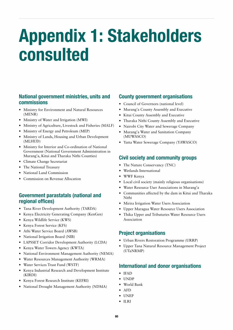
60
Appendix 1: Stakeholders consulted
National government ministries, units and commissions • Ministry for Environment and Natural Resources
(MENR)
• Ministry of Water and Irrigation (MWI)
• Ministry of Agriculture, Livestock and Fisheries (MALF)
• Ministry of Energy and Petroleum (MEP)
• Ministry of Lands, Housing and Urban Development (MLHUD)
• Ministry for Interior and Co-ordination of National Government (National Government Administration in Murang’a, Kitui and Tharaka Nithi Counties)
• Climate Change Secretariat
• The National Treasury
• National Land Commission
• Commission on Revenue Allocation
Government parastatals (national and regional offices) • Tana River Development Authority (TARDA)
• Kenya Electricity Generating Company (KenGen)
• Kenya Wildlife Service (KWS)
• Kenya Forest Service (KFS)
• Athi Water Service Board (AWSB)
• National Irrigation Board (NIB)
• LAPSSET Corridor Development Authority (LCDA)
• Kenya Water Towers Agency (KWTA)
• National Environment Management Authority (NEMA)
• Water Resources Management Authority (WRMA)
• Water Services Trust Fund (WSTF)
• Kenya Industrial Research and Development Institute (KIRDI)
• Kenya Forest Research Institute (KEFRI)
• National Drought Management Authority (NDMA)
County government organisations • Council of Governors (national level)
• Murang’a County Assembly and Executive
• Kitui County Assembly and Executive
• Tharaka Nithi County Assembly and Executive
• Nairobi City Water and Sewerage Company
• Murang’a Water and Sanitation Company (MUWASCO)
• Yatta Water Sewerage Company (YAWASCO)
Civil society and community groups • The Nature Conservancy (TNC)
• Wetlands International
• WWF Kenya
• Local civil society (mainly religious organisations)
• Water Resource User Associations in Murang’a
• Communities affected by the dam in Kitui and Tharaka Nithi
• Mirira Irrigation Water Users Association
• Upper Maragua Water Resource Users Association
• Thika Upper and Tributaries Water Resource Users Association
Project organisations • Urban Rivers Restoration Programme (URRP)
• Upper Tana Natural Resource Management Project (UTaNRMP)
International and donor organisations • IFAD
• UNDP
• World Bank
• AFD
• UNEP
• ILRI
61
• Climate Development Knowledge Network (CDKN)
• Royal Netherlands Embassy in Nairobi
Other (private sector, academic, consultants, individuals, etc) • University of Nairobi (various academic experts)
• Kenya Private Sector Alliance (KEPSA)
• Museums of Kenya
• Egis BCEOM Kenya
• Kenya National Chamber of Commerce and Industry (KNCCI)
• Be Associates
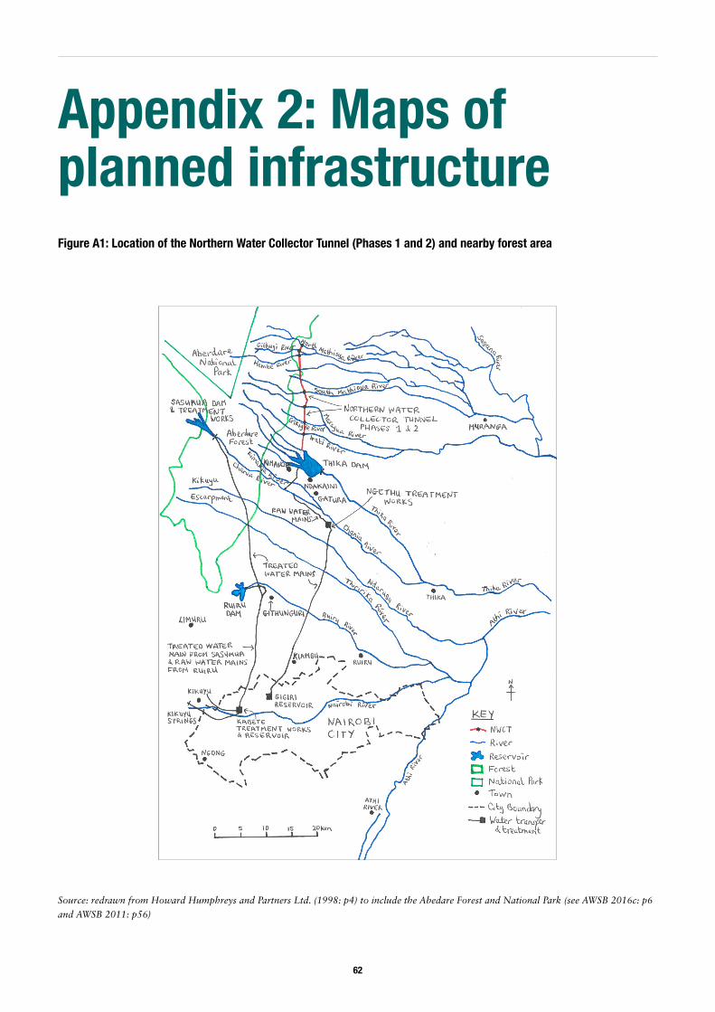
62
Appendix 2: Maps of planned infrastructureFigure A1: Location of the Northern Water Collector Tunnel (Phases 1 and 2) and nearby forest area
Source: redrawn from Howard Humphreys and Partners Ltd. (1998: p4) to include the Abedare Forest and National Park (see AWSB 2016c: p6
and AWSB 2011: p56)
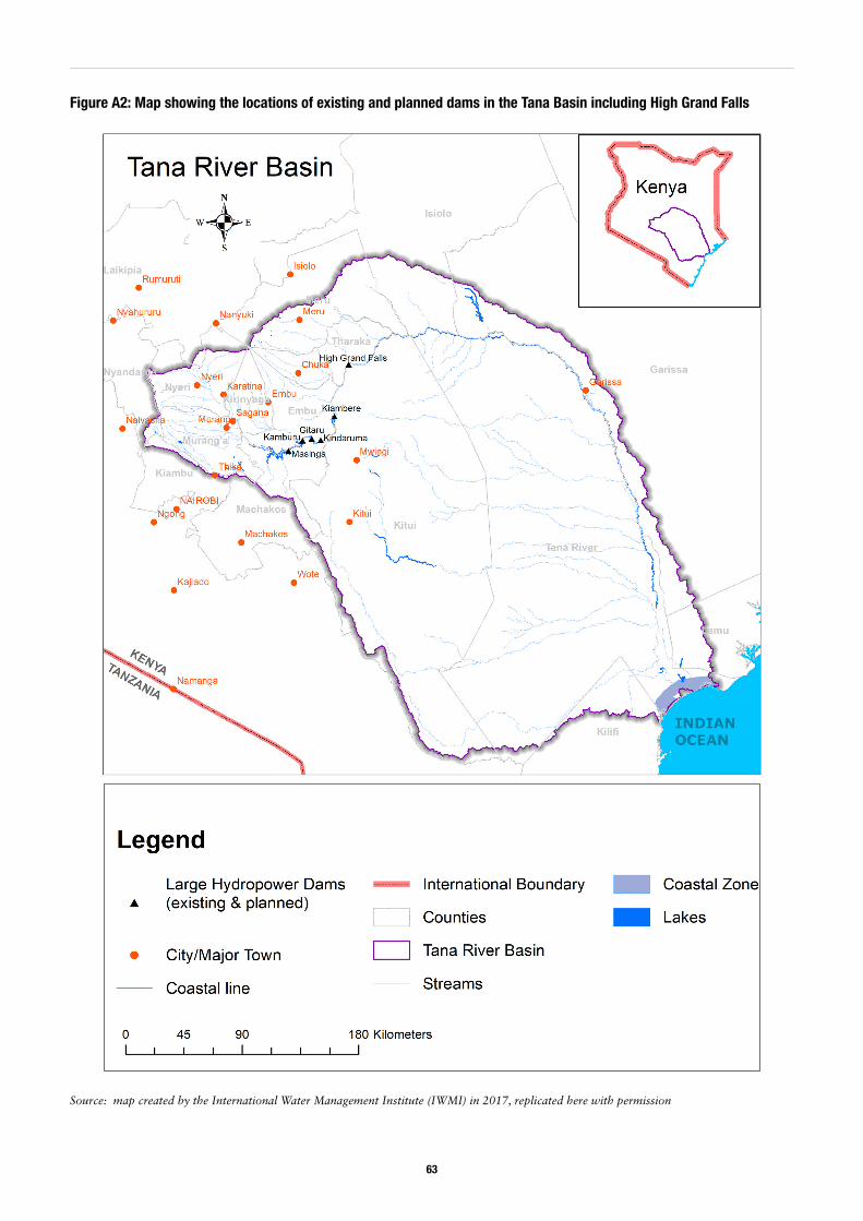
63
Figure A2: Map showing the locations of existing and planned dams in the Tana Basin including High Grand Falls
Source: map created by the International Water Management Institute (IWMI) in 2017, replicated here with permission
ODI is the UK’s leading independent think tank on international development and humanitarian issues.
Readers are encouraged to reproduce material from ODI Reports for their own publications, as long as they are not being sold commercially. As copyright holder, ODI requests due acknowledgement and a copy of the publication. For online use, we ask readers to link to the original resource on the ODI website. The views presented in this paper are those of the author(s) and do not necessarily represent the views of ODI.© Overseas Development Institute 2017. This work is licensed under a Creative Commons Attribution-NonCommercial Licence (CC BY-NC 4.0).ISSN: 2052-7209
All ODI Reports are available from www.odi.org
Overseas Development Institute203 Blackfriars Road London SE1 8NJTel +44 (0)20 7922 0300 Fax +44 (0)20 7922 0399
odi.org