Embed Size (px)
Citation preview

I APPROVAL SHEET
I
I ' Title of Thesis: A Floris t ic and Ecological Survey of Assateague
d Island, Virginia-Maryland
i k
Name of Candidate: Elizabeth Ann Thornthwaite Higgtns 1 Master of Science, 1969 E ,
f ,$U --, i A Thesis and Abstract Approved: , ,* % i Dr. Russel l G. Brown -
Associate Professor of Botany ! Department of Botany ,
Date Approved: A
I
I b
VITA
Name: Elizabeth Ann Thornthwaite Higgins
Permanent address: 6902 Wake Fores t Drive College Park , Maryland 20740
Degree and date to be conferred: Master of Science, 1969
Date of birth: November 17, 1927
Place of birth: Oklahoma City, Oklahoma
h 1 Secondary education: McKinley High School 1 Washington, D. C. I
i Collegiate institutions attended: Dates Degree Date of Degree
University of Maryland 1945-1950 B.S. 1950
I
University of Maryland 1963-1969 M. S. 1968 e i i i
Major: Taxonomy
I '^
I Minor: Botany
I Positions held:
Dates Position Institution Address
1950-51 Payrol l Clerk U. S . Dept. of Interior College Park, M Bureau of Mines
1961-62 Supervisor of Vineland State School Vineland, N. J. Cottage Life
1963-present Teaching Assistant Botany Department College p a r k , M University of Maryland
ACKNOWLEDGEMENTS
The author wishes to thank Dr. Russell G. Brown for the
i initial suggestion of this project, for aid in taxonomic determinations
1 and preparation of the manuscript; to Dr. F. J. Hermann of the U. S. i I Department of Agriculture Fores t Service, f o r determination of
i Carex and Juncus; and to Mr. Neil Hotchkiss of the U. S. Department
of Inter ior , Patuxent Wi ld l i f e Refuge, for h is g rea t enthusiasm and
aid in determinations.
Appreciation is acknowledged to Dr. Thomas Fairchild,
University of Maryland, and Mr. James Koch, U. S. Department of
Agriculture, Biometric s Service, for invaluable assis tance with the
s tat is t ical analysis; and to Mr. Anthony Norcio for his patience with
.* . ,:the computer program. Computer t ime fo r this project was supported
completely by the University of Maryland Computer Science Center'
facility.
The author is grateful for the cooperation of the staff of the
U. S. Department of Interior, Chincoteague Wildlife Refuge, and of
the National P a r k Service on Assateague; and to the personnel of the
Maryland Department of Fores t s and Parks , Assateague; and of Mr.
Tom Reed, Chincoteague, Virginia.
Much gratitude is expressed to Dr. Robert D. Rappleye for his
procurements and patience and most of all his perserverance.

And to my husband Joe, hear t fe l t thanks for encouragement,
understanding, loyalty, and company, without whose help this study
would have been impossible; and to Jay, Jenny, Jody and Louise f o r
both the i r to lerance and intolerance.
iii
TABLE
. . . ACKNOWLEDGEMENTS
. . . . . . . INTRODUCTION
. . . LITERATURE REVIEW
MATERIALS AND METHODS
CONTENTS
. . . . . . . . . . . . . . . . . Flo r i s t i c s
T ransec t s . . . . . . . . . . . . . . . . .
Soil and Water Samples . . . . . . . . . .
. . . . . . . . . . . . . . . . . . . . . RESULTS
. . . . . . . . . . . . . . . . . . Zonation
. . . . . . . . . . . . . . Zonal F lo r i s t i c s
1 . Dune Herbaceous Zone . . . .
2 . Shrub Zone . . . . . . . . . . .
. . . . . . . 3 . Arborescent Zone
. . . . 4 . M a r s h Herbaceous Zone
. . . . . . . . . . . . . . . . . Transec t s
. . . . . . . . . . Soil and W a t e r s a m p l e s
. . . . . . . . . . . . . . . . . . . . DISCUSSION
. . . . . . . . . . . . . . . . . Flo r i s t i c s
. . . . 1 . Dune Herbaceous Zone
2 . Shrub Zone . . . . . . . . . . . 3 . Arborescent Zone . . . . . . .
4. M a r s h Herbaceous Zone . . . . . . . . . . . . . .. 5 3
T r a n s e c t s . . . . . . . . . . . . . . . . . . . . . . . . . . . 55
Soil and Soil Water Samples . . . . . . . . . . . . . . . . . . 56
S u c c e s s i o n . . . . . . . . . . . . . . . . . . . . . . . : . . . 58
APPENDIX I. His tor ica l and Geological Aspec ts . . . . . . . . . . 61
APPENDIX II. Topographic and E c ~ l o g i c a l Notations . . . . . . . . 68
APPENDIX 111. Catalog of the Vascular P lan ts of Assa teague Island, Maryland-Virginia . . . . . . . 70
LITERATURE CITED . . . . . . . . . . . . . . . . . . . . . . . . . l o 3
LIST O F TABLES
Table
1 . Species common to two o r m o r e zones indicating their relative ecological frequencies . . . . . . . . . . . . . . . 36
2 . Comparative density and frequency of species in three strand communities (dunegrass, transition and mesic shrub) . . . . . . . . . . . . . . . . . . . . . . . . . . 38
3, Variation in soil salinity, pH, Mg, P2O5, and KzO a t the three soi l depths; water salinity and pH; and water table depth for samples taken i n dunegrass , transition and mes ic shrub communities in a r e a s where t ransec ts were made . . . . . . . . . . : . . . . . . . . . 40
Appendix Table
I. Number of t ransec ts , and distance (in dec imeters ) occupied by given species along 47 twenty me te r l ine
. . . . . . . . . . . . . . t ransec ts in the dunegrass community 99
2. Number of t ransec ts , and distance (in dec imeters ) occupied by given species along 59 twenty me te r line
. . . . . . . . . . . . . . . . . . t ransec ts inthe transition zone 100
. Number of t ransects , and distance ( in decimeters) occupied by given species along 58 twenty m e t e r line t ransec ts in the mes ic shrub community . . . . . . . . . . . . . 101
4. Data on variation in soil salinity, pH, Mg, PL05, and KLO a t three soil depths; water salinity and pH; and water table depth fo r samples taken a t s i tes of t ransec ts : 9 in dunegrass , 10 in transition zone and 11 in mes ic shrub community . . . . . . . . . . . . . . 102

LIST O F FIGURES
F igu re
1. A comparison of the vascular plant famil ies on four bar r i e r bars of the Atlantic Coast . , . . . . . . . . . . . . . . . 4 3
vii

LIST OF MAPS
i Appendix Map
1. Assateague and V i c i n i t y . . . . . . . . . . . . . . . . . . . . . . 67
viii
Martin, 1959); Cape Henry, Virginia (Egler, 1942); and The Outer
Banks of North Carolina /(Burk, 1961) have been subj.ects of plant taxo-
nomic and ecological studies. There a r e two brief taxonomic investi-
gations of Virginia islands south of Assateague: P a r r a m o r e (Harvill,
1965) and Smith (Clovis, 1968).
INTRODUCTION
Assateague Island i s an offshore bar comprising the south-
eas t e rn coast of Maryland and the northeastern coast of Virginia. It
is part of the system of discontinuous b a r r i e r reefs o r bars which
occupy most of the Atlantic shoreline f rom Florida to Massachusetts.
These a r e unstable bars , continuously influenced by s t o r m winds and
tides which provide a distinct and rigorous habitat for the vegetation
there.
Studies in other disciplines, and some botanical collections,
have been made on Assateague (Tatnall, 1942; Lems, 1966; Harvill ,
1967), but there has been no extensive botanical survey. General
f loras of the Delmarva Peninsula do not mention Assateague Island
specifically. Island Beach, New J e r s e y (Small and Martin, 1958; and
This survey will partially fill the void in l i te ra ture concerning
the Delmarva Peninsula. The objectives of the present study a r e to
prepare a catalog of the vascular plants of Assateague Island, and to

LITERATURE R E V I E W
The strand f rom New J e r s e y to South Carolina consis ts of three
distinct bars , separated by the Delaware and Chesapeake Bays, and
includes the transition between northern and southern f loras . This ! l i terature survey i s concerned with these three bars . ' Small (1929)
! describes southern New Je r sey and the Delmarva Peninsula a s
floristically s imi lar and a meeting ground fo r southern and northern I I
i plants. North Carolina i s included he re although Oosting (1954) con-
s iders i t par t of the southern strand.
The ear ly papers concerning strand vegetation along the middle
I
Atlantic Coast describe plant explorations--often reporting only new o r
unusual species. Such investigations of the New J e r s e y strand were
made by Knieskern &1857), Harshberger (1901, 1903, 19091, and
Chrysler (1930). Ear ly t r ips to Cape Henry, Virginia, a r e reported by
1. Inasmuch a s there is considerable l i te ra ture concerning world dune and m a r s h vegetation, both f lor is t ic and ecological, this review of dune vegetation i s limited to that of the middle Atlantic coastal s ta tes , North Carolina to New Je r sey , inclusive. Oosting (1954) prepared a comprehensive review of the l i te ra ture of the southern strand includ- ing.North Carolina.
The m a r s h habitat l i terature review he re includes works p r i - mar i ly of the eas tern United States. Many studies a r e available on marshes of the Pacific Coast, and Chapman (1960) has published an a l l inclusive Salt Marshes and Salt Deser ts of the World. - -- ---
4
Latrobe (1799) and Chickering (1878). Kearney (1900) made a careful
study of the vegetation there .
The bulk of l i te ra ture , both ear ly and current , concerils North
Carolina where the ba r r i e r reef extends along mos t of the coastline of
the state. The northern portion, the Outer Banks , i s composed of
three islands f rom the North Carolina boundary southward about 80
mi les . Ea r ly floristic surveys of these islands were made by Johnson
(1900), Kkarney (19001, Harper (19071, Lewis (1917).
I Several vis i ts to the Deimarva Peninsula a r e recorded. Canby I
1 (1864) noted species observed on a brief collecting t r ip to the Maryland
I I e as te rn shore. Chickering (1878) collected a t Ocean City, Maryland,
I which adjoined Assateague a t that time. Rusby (1891) published A - botanical excursion - to Assateague a. Although i t i s difficult to d e t e r -
mine just where he traveled, i t i s doubtful that he was on Assateague
Island. Chrysler (1910) prepared a r a the r complete l i s t of plants
growing in the coastal zone of Maryland. ' SnowJ1902, 1913) compared
changes in the vegetation around Rehoboth, Delaware, over a ten-year
period. Harper (1909, 1919), made two excursions to the center of the
peninsula, but did not visit the coast. T ides t rom (1913) and McAtee
A1918) recorded unusual species. Small (1929) made notes on the penin-
sula, comparing it with southern New Je r sey , but did not study coastal
vegetation.
The recent l i te ra ture i s generally m o r e detailed, including
ecological investigations in addition to plant species l is ts . Small and
Martin (1958) published a catalogue of vdscular plants of Island Beach,
New Jersey . It enumerates 267 species representing 63 plant famil ies
found on this ten-mile strand. In conjunction with that, Martin (1959)
considered environmental and vegetational relationships on the s trand.
Brown (1959) l isted about 400 species observed on the Outer
Banks f rom the Virginia border south to Ocracoke Island, but made no
voucher specimens. Burk (1961) made sixteen collecting t r ips during
two growing seasons on the Outer Banks and published a l i s t of 546
species representing 109 famil ies collected there.
The f i r s t complete f lora of any given a r e a on the Delmarva
I ~ ~ Peninsula was the F lo ra of Worcester County, Maryland, Redmond -- - 1 1 ~ (1932). It was based on collections made f r o m 1930 to 1932, and proba-
bly includes what i s now As sateague Island. Fernald (1935, 1936)
I collected i n Accomac County, which includes Chincoteague and the
~ Virginia portion of Assateague, but failed to specify vis i ts to ei ther .
Tatnall (1942) published the -- Flora of Delaware and the Eas te rn Shore. -- I
' ~ Although not specifying Assateague, he used the t e r m "dune" a s a
I I habitat, and ci tes two specimens f rom the island, deposited in the
University of Pennsylvania Herbarium, collected i n 1928 by Rodney
True. _A Catalog -- of the Vascular Plants - of Maryland, Norton and
Brown (1946) included specimens collected by Norton in Ocean City and 0
vicinity before 1932.
After a single day on Assateague, Lems (1963) compiled a l i s t
' ~ of 80 plant species he collected. Harvill (1965) pub1ished.a brief
survey of plant co~mmunities on P a r r a m o r e Island, Virginia, and in 1967,
The Vegetation of Assateague Island, Virginia. The la ter paper in- - - eluded a brief description of the pine and sa l t m a r s h communities, and
a l i s t of 123 species on the island. The a r e a he visited i s the widest
portion with the r ichest flora. Despite the fact that this a r e a contains
a t leas t ninety per cent of the species present on the island, he l i s t s
only a third of them. Clovis (1968) surveyed the vegetation on Smith
Island, Virginia, south of Assateague.
Analysis of any b a r r i e r reef vegetation inherently includes
m a r s h vegetation, a s the leeward or bayside of the reef i s a tidal sa l t
marsh . Marsh f lor is t ics and distribution were described by Ganong
(1903), Harshberger (19091, Johnson and York (1915), and Fernald
(1935, 1936), among others. They a l l recognized the species change
resulting f rom a slight change in m a r s h elevation, often of a few
inches, which produces a zonal pattern of plant distribution (Vogl,
1966). Wells (1928) divided the m a r s h associes into four socies by tide
levels. Johnson and York (1915) stated that species a r e related to a
specific submergence to emergence ratio, each species growing where
its own ra t io occurs. More recent papers, Reed (1947), Miller and
Egler (1950) and Eourdeau and Adams (1956)) have attempted to c o r -
relate vegetationa.1 zonation in marshes with elevation and other en-
vironmental factors. The difficulty here, a s with any other
environmental problem, i s to determine which factor is limiting while
dealing with all factors concurrently. High tides bring about change
in sa l ini t ies and cause poor aerat ion.
- In studying zonation within the m a r s h , i t i s genera l ly agreed
that salinity and inundation a r e the two m o s t impor tan t f ac to r s , but .
t h e r e i s l i t t le ag reemen t a s to which is the m o r e l imiting. Adams
(1963) showed that the dis t r ibut ion of spec ies i s controlled presulnably
by t ide-elevation f ac to r s , but other f ac to r s mus t be included: poor
d ra inage and aerat ion, and, a t upper m a r s h levels , competi t ion with
other angiosperms . Anderson, -- e t a l . (1968) demons t ra ted zonation of
spec ies , s imi l a r to that of a m a r s h , in an es tuary , moving ups t r eam
along a decreas ing sal ini ty gradient .
Chapman (1960) descr ibed the zonation of m a r s h vegktation and
w
stated that i t r ep re sen t s biotic success ion a s the m a r s h f i l l s in. Hinde
(1954) assumed aggradation i n m a r s h e s and s ta ted success ion occu r s
by l e s s hydric spec ies replacing the m o r e hydric ones. M a r m e r (1948)
demons t ra ted that the e a s t coas t h a s been sinking in re la t ion to s e a
leve l a t a r a t e of about 0. 02 feet p e r yea r ' s i nce 1930. Adams (1963)
s ta ted, "At the p re sen t t ime, the evidence shows that subsidence i s oc-
cu r r ing i n the m a r s h e s of the e a s t coas t a t a . f a s t e r r a t e than aggrada-
tion i n many a r e a s (Kurz and Wagner, 1957). Thus success ion m a y be
occur r ing i n a pattern opposite that suggested by (other) au thors . I '
Generalizations m u s t be l imited to specific coast l ines .
Oosting (1954) s ta ted, "The sand s t r and is a dis t inct ive habitat
and as such suppor t s a cha rac t e r i s t i c vegetational cover whose zona-
-- -- -I-- -- -
1
I 8
i
deecribd xep&tedly in-strand - l i terature and i e obvious to the most
casual &~rerver, Strand vegetation occurs i n bands, the life form
changing with distance away from the ocean. The zones o r bands have
been classified topographically (Cowles, 18 99) , and Snow, 1902) by .
describing vegetation along successive dune ridges parallel to the
ocean. The band adjacent to the beach is grassland, followed landward
by a band of shrubs, a band of woodland, and salt marsh at bayside.
These bands, or zones, a r e not homogenous nor continuous along a
strand. The width and development of any given zone varies with the
width of the strand--their presence being a function of the width of the
island. Vegetation within each zone varies distinctly with topography.
A distinct change in vegetation- -a mosaic - -accompanies a distinct
change in topography, whereas a gradual change in vegetation--an
ecotone- -occurs where the topograplychanges gradually.
Oosting (1954) categorized the strand vegetation a s follows:
I . Sand strand vegetation I. Treeless [open) 2. Trees and Shrubs (closed)
UI . Marsh vegetation 1. Salt marsh 2. Creek marsh 3. Dune marsh 4. Tidal flat
These marsh communities may occur within any of the broad life-form
bands on a barr ier reef, Ln much of the literature, considerable diffi-
culty i s expressed in categorizing marshes o r rnesic habitats on the
strand.
Egler (1942) listed seven zones on Cape Henry, Virginia:
1. Ocean zone 2. Beach zone 3. Salt-spray grassland zone 4. Sal t -spray Scrub zone 5. Fores t zone 6 . Tidal m a r s h zone 7. Bay zone
He described severa l vegetative communities within each of these zones
except the two which a r e aquatic. Mart in (1959), on Island Beach, New
Je r sey , mapped o r described 46 plant communities within s ix s t ruc -
tu ra l vegetation types:
1. Herbaceous communities 2. Low thickets 3. High thickets 4. Herb-shrub mixtures 5. Transitional thickets 6. Woodland
Historically, in dune studies, as in m a r s h studies, t he re a r e
many theories to explain the cause of zonation of the plant communities.
Wells and Shunk (1931) stated that low water and nutrient content of the
soi l prevent development of mesic vegetation and maintain the re la-
tively stable communities of the zones. B y 1938, they suggested "that
the distinctive composition of the dune community is based pr imar i ly B I 1
upon the species adaptations to the (salt) spray factorr1. Mart in and
Clements (1939), working i n Sout-hern California, studied many environ-
mental factors and concluded that the available water and nutrients
determine vegetation. They a l s conducted salt spray tes ts , spraying 9 solutions of "table salt1 ' on plants transplanted to a control garden, and
found little damage to s t rand plants; however, inland species were
ser iously injured. Their conclusion was that sal t sp ray prevents
species f r o m becoming established in a foredune a rea .
In what i s now considered a c lass ic ecological study, Oosting
and Billings (1942) studied soil moisture , osmotic concentration, pH
and temperature; a tmospheric temperature, evaporation and relative
humidity, but could not relate the variation to zonation a c r o s s the
strand. Oosting (1954) summarized their significant findings, stating
that, when they measured sal t transported and deposited b y wind,
" regard less of weather , the highest catches-.(of sa l t ) were on the windward side of the foredune, the c r e s t of the foredune showed the next highest values, and the c r e s t of the r e a r dune was next in o rde r , with the de - pression between receiving much l e s s . I '
Boyce (1954) confirmed these observations. Thus, a l l th ree authors
concluded that sal t spray i s the one environmental factor which con-
t ro l s zonation.
Martin (1959) agreed that sal t spray de termines zonation, but
that the interception of sal t spray and sand movement a r e determined
by the topography of an area- -hence topography i s a l so a pr ime factor .
He descr ibed a three-way interaction of topography, vegetation, and
environment, and considered environmental fac tors to be pr imar i ly
sa l t spray and sand moved by wind. Perhaps the c rux of causes of
dune zonation a r e summarized in his statement, "Sand and sa l t ' spray
determine vegetation, vegetation influences topography, topography
influences deposition of sand and salt.
Zonation a c r o s s the s t rand gives the appearance of ecological
succession- -herbacouous to shrub, to pine woodland, to deciduous
fores t communities. Many authors accept zonation a s succession of a
' p r i s e r e ; however, two opposing opinions a r e expressed in the l i te ra-
ture. Chapman (1964) called it succession- -a p r i se re - -and presents a
diagram of the stages. Chadwick and Dalke (1965) refer red to the
Idaho inland dune vegetation a s a succession., Oosting (1954) did not
accept the concept of biotic succession a s applicable to zones of the
mari t ime strand, since there i s no proof that the zonation indicates
ei ther the direction o r existence of succession. He believed that
apparent successional relationships a r e primari ly physiographic.
Martinx1959) stated that the environment inhibits autogenic succession;
cession advances, but there is no reason-that the so-called s e r e s of
the coastal communities, arranged depending on the environmental
gradient, should be regarded a s succession. I t
The f lor is t ics of many strands have been catalogued, the vege-
tation zones have been classified, and a cause of zonation presented,
but very little work has been done on adaptation and function of the indi-
/
Wagner (1964) conducted an environmental study of Uniola paniculata L . ,
1 11 a southern strand plant. He found maximum growth occurred where
ii new layers of sand, coated with sal ts providing nutrients, were
I 1 I available. Laing (1958) has determined the reproduction of Ammophila
I1 11 breviligulata, the ubiquitous sand binder, to be pr imar i ly
vegetative. Agnew (1961) described the plant species associations of I 1 Juncus effusus, in English marshes . There is a l a rge body of l i t e ra - l
ture , partly cytological, concerning Spartina species in English
m a r s h e s (Ranwell -- et a l . , 1964; and others) . Burk (1961) studied hybridi-
zation of oaks on the North Carolina strand and morphological variation
of Heterotheca subaxillaris in relation to i t s taxonomy. Sweitzer (1968)
determined the effects of shading on Salicornia Biglovii growing on
As sateague Island. Salt tolerance determinations on a number of plant
species have been made by Taylor (1939), Oosting and Billings (19421,
I Kurz and Wagner (1957), Martin (1959), Chapman (1960, 1964), and I 1
others. -
It is c lear that a relatively few plant species a r e able to s u r -
vive on the strand and, of those, no one species appears able to adapt
to a l l strand habitats. Although the above is only a part ia l listing of
/ / autecological studies, it indicates the strand is an a r e a available for
m o r e detailed study of specific plant taxa and their adaptation to'a
particular environment.
MATERIALS AND METHODS
F lo r i s t i c s , Assateague Island i s a n offshore b a r r i e r b a r on the
southeastern coas t of the Delmarva Peninsula , located just south of
Ocean City, Maryland, in Worces te r County, extending southward to
Chincoteague, Virginia, i n Accomac County. I t i s separa ted f r o m the
mainland by the Sinepuxent and Chincoteague Bays.
Assateague was pa r t of a continuous peninsula extending f r o m
South Bethany Beach, Delaware, to Chincoteague, Virginia. A s t o r m in
I I 1933, cut an inlet , since designated Ocean City Inlet , through the bar
I f jus t south of Ocean City, Maryland, making Assateague a s epa ra t e
. i s land , about 32 m i l e s long, 23 m i l e s i n Maryland, and the r ema inde r
in Virginia. The width v a r i e s f r o m one-half to t h ree mi l e s . Lack of
a c c e s s and low elevation have d e t e r r e d development, and Assateague
r ema ins one of the l a s t re la t ively undisturbed shore l ine a r e a s along
the Atlantic Coast. 2
An annotated check l i s t of vascu la r plants of Assateague Island
was prepared f r o m observat ions of thi r ty collecting t r i p s made during
the growing seasons (April to November) f r o m 1965 through 1967.
2 . F o r additional information concerning the h i s to r i ca l and geological ~ aspec t s of the island, s e e Appendix I .
Approximately 2 , 000 specimens were collected, p ressed , identified,
and labeled.
F o r identification, The New Britton and Brown I l lustrated F l o r a -- - of Northeastern United States ahd Adjacent Canada by Gleason,. and - - Gray's Manual - of Botany by Ferna ld were used. Nomenclature in the
check l i s t follows Ferna ld unless otherwise noted. Other manuals
which were a l so useful include: Daubs, A Monograph - of Lemnaceae;
Fasse t t , - A Manual .- of Aquatic Plants ; Gleason and Cronquist, Manual
of Vascular Plants of Northeastern United S ta tes and Adjacent Canada; - - - Hitchcock, Manual -- of the G r a s s e s of the United States; Hotchkiss, -- Underwater - and Floating-leaved Plants -- of the United States - and Canada;
Redmond, The F l o r a of Worcester County, Maryland; and Tatnall, The --- - F l o r a of Delaware and the Eas t e rn Shore. Voucher specimens a r e de - .-- 4--
posited in the Herbar ium of the University of Maryland, College P a r k , J.
Maryland. A duplicate s e t i s to be deposited a t the Headquarters of the
U. S. Department of In te r ior F i s h and Wildlife Service on Assateague.
Transec ts . An ecological study of two vegetational zones and
the transit ion zone between them was conducted i n June and July, 1967.
Line t ransec ts , twenty m e t e r s long, w e r e taken i n the three f lor i s t ic
a r eas - -47 i K the dunegrass community, 58 in t ransi t ion zone, and 5 9
in the shrub community for a total of 164. T ransec t s i t e s were selected ,
randomly within the th ree communities. However, the dunegrass com-
munity t r ansec t s purposefully included those in f ront and behind the a r t i -
ficial b a r r i e r dune, and some located where t h e r e is n o b a r r i e r dune.
Transects rather than quadrats were used i n this study because
some of the a r e a s surveyed are almost impenetrable, dense shrub
thickets. Oosting (1948) notes that t ransects a r e particularly useful
in dense stands of scrubby vegetation, and give reasonably accurate
information. Kershaw (1964) discussed sample size, o r number of
transect samples required in any given study. He concluded that with
l a sample s ize of l e s s than 100, only gross differences. in speciation a r e
I i detectable. Since, in this study, approximately 50 transectswere made
in each of the three communities, species occurring with a frequency
of l e s s than five a r e not considered significant. I A twenty m e t e r tape, marked in decimeters , was laid a c r o s s
the vegetation. Number and coverage of each species touching the tape
was recorded. F r o m this, density and frequency of species were
determined. Density reported here i s the average number of individu- e
als per decimeter . Frequency i s the percent of the total samples i n
which the species occur. Together these values give an est imate of
cover of individuals and their distribution.
Topographic and ecological frequency terminology i s included
in Appendix II.
Soil and water samples. Inasmuch as the causes of zonation --- are generally accepted to be an interrelation of topography and sal t
#
..-deposition, these factors were not tested in this study. The soils and
soil water of the t ransect a r e a s were sampled to determine variations \ '
1 between the three cornrhunitie s. I

Soil samples were collected a t the s i tes of the t ransects , nine
sited in-the dunegrass community, ten in the transition zone and eleven
in the shrub community. At each sample a r e a a pit was dug to the
water table. Water samples were taken f rom the watertable; s,oil
samples at the surface, 20 cent imeters below the surface, and a t the
water table. The soil samples were a i r dr ied and analyzed by the Soil
Testing Laboratory, University of Maryland, using methods described
by Miller -- et al. (1963). pH, magnesium, potassium a s K20, and phos-
I
i phorous as P2O5, content were determined. The reliability of the data
I I i
is a s follows:
pH - + . 0 5 Mg + ,125 pprn.
P205 E . 625 ppm. K20 fi ,375 ppm.
Soil salinity determinations were made using the method des- I
cribed by Miller -- et al . (1963) on an Lndustrial instruments conductivity
I: rr bridge, Model RC-BC. Soil water samples, collected f rom the water- I t
1 table were measured for salinity directly, on the same conductivity
I I bridge. Their pH was measured immediately af ter collection in the
field using a Beckman pocket pH meter , Model 180. Buffered solutions
of known pH were used in the field to check the meter . Statistical
analysis was car r ied out a t the University of Maryland Computer I ,
Science Center, using Analysis of Variance for one-way design, v e r - i I
; sion of June 15, 1966, Health Sciences Computing Facili ty, University
of California, Los Angeles. A transformation to logarithms was
required on some data where the variance varied with the mean.
Duncan's Multiple Range Test (Steele and Tor r i e , 1960) was applied to
determine significant differences of variable means between
communi ti e s .
RESULTS
The vascular plants of Assateague Island, collected in this
study number 441 species representing 88 families. (The annotated
l i s t of species appears as Appendix 111. ) This does not include two
species collected on Assateague by Rodney True i n 1928 (Tatnall,
19421, Plantago major - var . intermedia Dcne. and Oenothera perennis L. ,
o r two species l isted by Harvill (1967), Lobe,lia siphilitica L. and
Plantago mar i t ima L. These species have been sought but not found by
the author.
Zonation. Vegetation bands or zones on Assateague a r e the
s a m e a s those described on other ba r r i e r strands. F r o m the ocean
toward the bay they proceed in o rde r f rom the beach, dunegrass , shrub,
arborescent , and m a r s h running i n bands paral lel to the ocean but
often interrupted. Occasionally the communities comprising the zones
a r e distinctly separated one f r o m another by a sha rp topographic
change- -forming a mosaic. Generally, however, the f lor is t ic com-
position gradually changes f rom one community to the next--producing
a floristic ecotone which i s difficult to descr ibe .
A factor m o r e striking than the mosaic pattern, although par t
of i t , is the xe r i c and mesic situation within each zone--each with a
distinct vegetational society. Within any zone, a depression which 2 ; t
[ brings the soil surface closer to the water table, also brings a change f i in floristic composition. In the dunes these may be small and provide
, a minor component of the zonal floristics, or , a s in the shrub zone,
they may be extensive. The mesic shrub community composes one-
third of the entire shrub zone area.
Zonal floristics. A brief description of vegetational zones--
their major communities and the distinct minor communities within
them follows. The communities discussed are : dunegrass; xer ic and
mesic shru.b; pine and pine deciduous mixed woodland; f resh and sal t
marshes. Included within these a r e typical minor communities:
beach, Hudsonia dunes, pans and washes, impoundments and ponds,
and one atypical site by the Light house. Also described i s the t rans i -
tion zone or ecotone between the dunegrass and mesic shrub communi-
ties, where t ransects were made. Included with the description of the
major communities is a l is t of species occurring primari ly in that one
community. The minor communities within the zones a r e described
and species found in them a r e listed.
A compilation of species occurring across the strand in two o r
more zones o r communities is shown in Table 1. The species l i s t and
ffequency values are observations of the author, except in dunegrass
and mesic shrub, where t ransect data a r e included with observations,
Ecological frequency notations apply only to the one habitat; general
I frequencies fo r the entire island a r e included in the Annotated Check
List in Appendix In.
1. Dune Herbaceous Zone
Beach. Plant cover above the high tide line (the upper beach)
is not over 170. Beach pioneers appear only occasionally- -often in the
shel ter of driftwood. Cakile edentula i s the mos t frequent species, pro-
ducing many seedlings, but few adult plants. The seed source i s
apparently f r o m plants of the foredune o r b a r r i e r dune where i t
ma tu res under slightly m o r e stable conditions than on the beach.
Salsola Kali and Amaranthus pumila a lso occur on the beach, but
ra re ly . There a r e two mounds, about two m e t e r s in-d iameter ,
covered with Arenar ia peploides in Virginia, where this species ap-
proaches i t s southern limit. . -
Dunegrass Community. This i s , f loristically, the mos t uniform
of the vegetation zones on Assateague, extending continuously the
length of the island behind the beach, a band seventy m e t e r s o r m o r e
i n width. The habitat i s of unstable, low .rolling dunes, exposed to
strong winds and much sand movement. Here an ar t i f ic ial ba r r i e r
dune has been constructed. Cover in this community is 20% o r less .
Ammophila breviligulata, American Beach Grass , is the dominant
species. Spartina patens i s most commonly associated with it. The
presence of Panicum amarum and _P. amaruluin ranges f r o m r a r e in
Virginia to frequent northward. The only forb occurring commonly i s
Salidaeo s e m ~ e r v i r e n s .
Species occurring in the dunegrass zone and not generally found in
other communities a r e l isted below:
Frequent Rare
Cenchrus tribuloide s Digitaria sanguinalis Euphor bia polygonifolia Panicum m e ridionale Oenothera humifusa var . a lbemarlense Xanthium Strumarium
Local Infrequent
Amaranthus pumilus Cyperus s,trigosus Polygonum glaucum Erigeron pusillus Sesuvium m a r i timurn Solidago sempervirens var. mexicana Spergularia mar ina Triplasis purpurea
The dunegrass community gradually changes into the shrub zone,
where Ammophila breviligulata i s replaced by Andropogon virginicus
! I as the dominant g rass . In a few isolated a r e a s where the dunegrass i li' IP and shrub zones a r e wide, there i s a tension zone containing low, I,
scat tered Myrica cer i fera , Ammophila breviligulata and Andropogon
spp. , with the fpllowing herbs which a r e not often found elsewhere: ,
Chenopodiurn ambrosioides, Datura Stramonium, Er igeron pusillus,
Oenothera humifusa and Solanum nigrurn.
Dunegrass-Shrub Transition zone. Between each of the vegeta-
tive bands along the s trand i s a transition o r tension zone- -an ecotone- -
where f lor is t ics change f rom one community to another. The widest,
i.r
most apparent of these, i s that between the dunegrass and shrub corn-
t munities. This zone i s continuous the length of the isiand behind the
8
d unegrass community. Elevation i s consistently low, varying
I -
gradually f rom one to two m e t e r s above sea level. Cover provided by
herbaceous plants i s 60 to 70%, while shrub cover i s 20 to 30% of the
total. Where blowouts have occurred and. elevations a r e close to the
1 ' water table, a m a r s h community s imi lar to that present in blowouts in
island except in pans and impoundments. This zone mus t be considered
I I 1
a s two communities, because of the la rge s ize of both xe r i c and mesic
the dunegrass zone appears . The species of this zone, found in 58
t ransects a r e listed i n Table 2.
2. Shrub Zone -- Xeric Shrub Community. The shrub community i s the second
band of vegetation parallel to the ocean extending the length of the
shrub communities. The xe r i c shrub zone extends over secondary
dunes where elevations vary f rom one to three m e t e r s . At lower e le-
vations where the land is flat, the dominant shrubs a r e low--about one
meter ; l ianas a r e ve ry abundant, and herbaceous cover is 80% o r
I / i 6 more . On the dune ridges and slopes, where elevations a r e over one 11 i/
ii meter , shrubs a r e ta l ler and provide m o r e cover; l ianas a r e few, and t/ I
I the -herbaceous cover is 30% o r less . The species collected only in
ii this community are l isted below:
t I/
1' I/ Frequent Infrequent -(contld. ) I I $1 Amelanchier canadensis Polygonella ar t iculata
i/ , Py rus angustifolia var . spinosa P y r u s arbutifolia ' i Infrequent
Argostis hyemalis Eragros t i s spectabilis ,
R a r e
Aral ia spinosa Prunus mar i t ima Sambucus canadensis

Species f rom swales within the xer ic shrub community:
Frequent
Juncus marginatus var . biflorus P te ridium aquilinum Juncus Gerardi
Infrequent
Osmunda r.egalis Solidago. fistulosa Panicum sphaerocarpon
Rare
Galium pilosum Paspalurn leave
Hudsonia Dunes. Interspersed within the xe r i c shrub community-
a r e flat, open dune ridges f r o m two to three m e t e r s high, which have
an herbaceous dominant, Hudsonia tomentosa. Cover on these
*secondary dunes i s l e s s than 40'7'0, composed of the following species:
Abundant
Andropogon virginicus Hudsonia tomentosa Lecchea mar i t ima
Common
Bulbostylis capi l lar is Hypericum gentianoide s Polygonella ar t iculata Rumex Acetocella
Frequent
Aristida tuberculosa Linaria canadensis
Infrequent
Cynodon dactylon Mollugo ve rt icil lata Opuntia humifusa
Occasionally another herbaceous community occurs in small ,
open a r e a s within the shrub zone-- less frequently than the Hudsonia
society. Frequency values a r e low f o r a l l species.
Andropogon virgini,cus Aristida tuberculosa Hypericum gentianoide s Krigia virginica Opuntia humifusa Polygonella ar t iculata ,
Mesic Shrub Community. Interspersed within the shrub zone
a r e extensive mesic sites where elevations a r e very low--less than one
'meter above the water table. The mesic shrub community occurs her:.
The shrub cover varies from 90 to 10070 and forms a dense thicket.
The herbaceous cover varies from 10 to 80% and includes numerous
seedlings of the dominant shrubs. Species of this community a r e
shown in Tables 1 and 2. Species collected only in this community a r e
listed below:
Infrequent Rare
Cyperus filiculmis Cassia nictitans Eupatorium pilosum Smilax Walteri Ilex glabra Vaccinium ceasariense Juncus coriaceous Viburnum recogniturn Panicum lanuginosum Sagina decumbens
3. ~ r b o r e s c e n t ' Zone
Pine Woodlands. Pine woodlands form the third band of vege-
tation landward from the ocean. It i s not continuous, but broken inter -
mittently by the salt marsh where the island narrows. The cover
varies from SO to 90% on dune ridges and swales, and elevation ranges
from three to ten meters. The dominant species is Pinus Taeda.
Pinus virginiana i s also present in three small stands. Pine wood-
lands range from thickets composed of many species, generally repre- ' /
0 senting the xeric shrub community, to an open, pure stand of mature
P. Taeda.
Infrequent ' Local
Agrostis alba Cypripedium acaule Cyperus re t ro r sus Pinu s vi r giniana ~e l i an t ' hemum canadense Hieracium Gronovii
pine-deciduous mixed woodland. The highest, oldest dunes on
Assateague, located a t the widest portion, a r e in the a r e a around the
Light house near the southern tip of the island. Here the dunes reach a
height of sixteen meters . The elevation and distance f rom the ocean
provide maximum protection f rom sal t spray. According to Oosting
(1954) such dunes a r e shifting landward; hence vegetation i s subjected
to coverage by moving sand; however, there i s little evidence of that U
in this a r e a on Assateague.
It is here, behind the pine woodland zone, that a deciduous
woodland is expected, but i t i s not present a s a generally homogenous
community. .Most of what probably was deciduous woodland has been
cut over recently and is nowtypical pine woodland. This is in the
a r e a around the Light house where there was a village until the 1930's.
To the north of the pine woodland, on the same dune ridge,
occurs one smal l a r e a of deciduous woodland. It i s limited to the lee-
ward slope of the highest dunes (known a s the White Hills). The cover
is 100%, provided by a high canopy of Quercus falcata, with - Ilex opaca,
, Vaccinium atrococcum, and Gaylusaccia baccata.
kt the low behind the dune ridge is a la rge depression with
stan$ing water most of the year. 'The deciduous species change
abruptly here . The dominant i s Acer rubrum with Salix nigra.
The foreslopes of the White Hills a r e almost devoid of vegeta-
tion. Only an occasional plant of the Hudsonia association appears . F
5 South of the pine woods around the Light house, extending to the
beach a t Tom's Cove, i s a se r i e s of dune ridges and hollows, where
the dominant i s s t i l l Pinus Taeda, but it i s mixed with la rge numbers
1 of deciduous species. Here i s the most dramat ic evidence of change in ! 1 i i
vegetation with change i n topography. The dune ridges a r e covered
with open woodlands of largk - - P. Taeda, often over thirteen m e t e r s
tall, and Quercus n igra- -a lso old t r ees , but r a re ly reaching over ten
meters . Although the cover he re i s close to 80%, i t i s a low canopy--
1 not over eight me te r s high. Ground cover i s l e s s than 20%. Along the : ti edges where there has been some soi l disturbance, Phytolacca
americana and Rubus cuneifolia occur. Y I
In the lows between the dunes a r e dense thickets formed by
species the same a s those in Myrica shrub thickets, but here they a r e
{ I taller and apparently older. The cover i s 100yt--a dense tangle of I i
1
t rees , shrubs, and lianas about seven meters tall. 1 i I In larger swales between dunes is a mixture of Myrica spp.
and deciduous t r e e species (Acer rubrum, auercus nigra, 2. falcata,
r I - Salix nigra, and Sassa f ras albidum. ) The t r ee canopy is open, ten to
1 L
i twelve m e t e r s high, with a dense shrub layer below, covered with b
I lianas. Juiperus virginiana is r a r e in this a rea , and each plant is
1 completely covered by l i h a s . ' 1
1.
The bayside of this fores t is eroding visibly a t this t ime. At
high tide water covers the base of dead t r e e s which a r e s t i l l standing,
and the sandy shore is li t tered with dead t r e e s and stumps which a r e
remnants of the fores t now in the bay. The beach mater ia ls being cut
away h e r e i s deposited further south along the shel tered beach in
Tom's Cove. The dunes receiving the deposits a r e encroaching on the
fores t , and covering t r e e s with sand seven to ten m e t e r s high. The
new dunes a r e barren, with the exception of Solidago sempervi rens ,
Myrica ce r i f e ra and Prunus serot ina which have survived burial.
Species found in the mixed woodlands and not elsewhere a r e
l isted below:
Local
Berchemia scandens Monarda punctata Cornus florida Quercus stellata
Xanthoxylurn Clava-Herculis
The Lighthouse stands on a dune ridge in the pine-deciduous
woodland. The leeward slope i s unusual in that i t has a n herbaceous
cover of loo%, where other la rge dune slopes have a lmost none.
Species found h e r e , with one exception, a r e not found elsewhere on the
island. Some a r e re l ics of cultivation, but the origin of others on
Assateague i s in question. Species on the slope a r e shown below.
Frequencies a r e not given because there a r e s o few representat ive
plants of each species present.
Arenar ia serpyllifolia
Akebia qufnata
Ligustrum vulgare also found nea r hunters cabin in Maryland
I Althaea rosea Nepeta catar ia
Asparagus officinalis Oxalis europaea var . Bushii
1 Aster dumosus var . cordifolius Pa r ie ta r i a floridana
Boehmeria cylindrica Portulaca oleracea
Chrysanthemum Leucanthemum Robina Pseudo-Acacia
i B i I Commelina communis Sanicula canadensis '. .
Crataegus c r u s - galli , Verbena officinalis I I P Geum canadense Xanthoxylum Clava-Herculis
I b
frequent on sand strands Helianthus petiolari s south of Assateague
L
'/
1 Lamium amplexicaule
I
4. Marsh Herbaceous Zone , 1 ; Salt marsh . Covering the bayside of Assateague i s the second 1) I E i
1; herbaceous zone of the four major vegetative zones which occur on I !
bar r i e r bars. This is the sal t m a r s h where Spartina patens i s the E
~1 dominant species. Spartina marshes line the bay shore for the length I i li . .
1 .of island, except at the widest portion where the pine-deciduous wood-
1 1 ii
land adjoins a sandy Beach at bayside and along Tom's Cove. Generally !I I! /I
" they a r e narrow where the backdunes a r e high and well wooded, and :t
1 wide where the island i s low and narrow. Salinities vary f r o m low to '!
1 - Pi high marsh . Low marsh , inundated daily by tides, have salinities ?! ,iI 11 lower than the bay--about 23 ppt. The high marsh , inundated only by $1 ,I 4. exceptionally high tides, shows higher salinities, up to 30 ppt. 3
Estimated elevations a r e seldom over half a me te r above sea level.
~ e r b a c e o u s cover is 10070, forming a mosaic within the low and high
Within the extensive marshes a r e hummocks--raised a r e a s one
to two mete r s above the m a r s h level and twenty to thirty me te r s in
diameter. It was not determined whether these a r e remains of once
la rger dunes or whether they a r e building up in the marsh . Since they
3 i a r e covered with a well developed xer ic shrub community, the same a s X
found in the shrub zone, i t appears that the hummocks were once
" 4 1 continuous with the dunes.
At some time previous to this study, drainage ditches were dug
in many of the m a r shes for mosquito control. The ditches and the mos -
i quitoes a r e s t i l l there, just a s they a r e on Island Beach (Martin, 1959).
The ditch edges, where sand was piled, now support the shrubby
1 ) - Iva frutescens, forming narrow rows of plants visible for long dis- I ? i I t t tances through the marsh . * +
Species occurring in sal t marshes a r e listed below. No
attempt was made to gather quantitive data a s simple t ransects o r j j quadrats would not show the mosaic. A detailed vegetative map would : I
f i be required to give the spatial relationships of species.
Frequent Infrequent
A. tenuifolius As te r pilosus var . demotus Bassia hir suta Polygala verticil lata Juncus biflorus var. isocycla Limonium c,arolinianum Pluchea purpurascens Rare Salicornia spp.
J Borrichia frutescens
Ludwigia alternifolia
F r e s h Marsh. A m a r s h a s defined by Webster is "a tract of
. soft wet land, usually character ized by monocotyledons. ' 1 The
connotation i s a large t ract . On Assateague, the la rge marshes a r e
sal t marshes adjacent to the bay. F r e s h marshes a r e limited in size
and occur in a r e a s within the vegetative zones where ground level
approaches water table--generally in dune swales or s i tes of blowouts.
Species composition var ies with the size of the depression and the
broad zone in which i t i s located.
Blowouts supporting f resh marshes in the dunegrass and t rans i -
tion zones a r e unshaded; herbaceous species provide 100% cover.
Eleocharis parvula with few associates covers a r e a s where there i s
standing water par t of the year, and has a remarkable ability to invade
these a r e a s on kssateague a s well a s in North CarolinaABurk, 1961).
Pools present in the spring a r e ringed with a narrow band of this
species. As the pool drie; out, - E. parvula follows the water table
until no water remains, which resul t s in a solid mat of vegetation. If
the s i te remains d ry , Juncus bufonius and Spergularia mar ina appear
in association with it . In other s i tes with a shallow water table, but
apparently better drained, Sci r pus americanus and Juncus bifloses
occur--often in large a r e a s .
The smal l f r e sh marshes within the mesic shrub community a r e
densely shaded by the Myrica thicket, but herbaceous cover' he re is
s t i l l 90 to 100q0 and composed of Dryopteris Thelypteris, Festuca rubr%
.--Spartina patens, and ~ u l p i d octoflora.
The marshes in the xer ic shrub and Hudsonia communities a r e
often only smal l sinks in the dunes. These show much. species variation
Polypogon monspeliensis, Scirpus americanus and Spartina patens a r e
most often present, but species found in association with them vary
widely f rom one m a r s h to the next. ,In one l a rge m a r s h near Ragged
1 Point, between Hudsonia dunes, Vaccinium macrocarpon was found.
I I This i s the only station where i t occurs , although i t was expected to be
prevalent. In this same a r e a Drosera intermedia occurs in a dense stand,
and this i s one of the few places where i t i s found. F r e s h m a r s h e s within +
I i the arborescent zone a r e s imi lar to those within the shrub zone;
l h Species found in f r e s h marshes a r e l isted below:
I I; Common Infrequent (contld. ) 11 , i Eleocharis rostel la ta Eupatorium serotinum I I Juncus dichotomus Fui rena pumila i \ I Polygonum punctatum Gnaphalium obtusifolium i $
Heterotheca subaxillari s
I Frequent Ludwigia alte rnifolia i Lythrum l inare
R I Argost is alba var. palustr is Panicum columbianum var . oricola
r Cyperus filicinus Rhynchospora capitellata I Galium obtusum R. gornerata f
i Hypericum boreale Scirpus cyperinus i H. mutilum Setar ia geniculata
1 ! H. virginicum Spiranthes spp. /i Linum medium Xyris spp. j $ 1 i Lycopodium inundatum 1 i. Polygonurn pens ylvanicum Local i i
, Samolus parviflorus Spergular ia mar ina Drose ra intermedia I! Viola lance olata T ypha angus tif olia
ii T. latifolia I# Infrequent
fl C
R a r e ,I/ Carex hormathodes :I 3~ Cyperus esculentus Arnrnania t e r e s
Dioda virginiana Bacopa Monnieri Eclipta alba Vaccinium macrocarpon
Washes and sal t pans. A wash is a low area open to both the
bay and the ocean, and inundated with salt water at exceptionally high
tides. They a r e present on s i tes of inlets. One such wash i s just
south of Green Run. Another, fa r ther north has been closed to the
ocean by the artificial ba r r i e r dune. A third, south of Ragged Point i n
Virginia, has been closed by a dike a t bayside and the ba r r i e r .dune
along the beach- -forming a sal t pan.
These three a r e low, flat expanses of sand, not over a me te r
above sea level, sided by low dunes, and lying perpendicular to the
ocean. Salinities he re a r e higher than in the bay due to accumulation
of salt a s evaporation takes place. They a r e barren; vegetation is
restr icted to the edges in the shel ter of the dunes, o r on an occasional
low, actively forming dune within the wash. The s a m e micro-zonation
occurs he re a s in the tidal marshes . Species a r e specific to one level
and rare ly t r ave rse topographic change.
Pioneers on the wash or pan level a r e only the most salt
tolerant and a r e l isted below: 4 * Aster isk denotes species which
bridge two o r more societies within this community. )
Amaranthus pumillus 4 Atriplex arenar ia * Cakile edentula Polygonurn glaucum Salicornia Biglovii
Salicornia europaea Salsola Kali Sesuvium maritimurn Spergularia mar ina
The dunes along the edge of washes and pans progress f r o m low
sand mounds to dunes a mete r high with swales between. Moving out ,
of the wash or pan level to the dunes, the vegetation changes a s shown
:; Aster subulatus var. euroauster Juncus bufonius Bacopa Monnieri - Virginia only * Scirpus americanus Bassia hir ta 4: Solidago sempervi rens ~ ' ~ ~ e r u s filicinus * Spartina patens * Distichlis spicata
Behind the f i r s t dune ridge i s often a depression- - a flat a r e a which
possibly was part of the salt pan 'at one time. The vegetation he re i s
typical of f r e sh m a r s h co~nmuni t ies within the shrub zone;
Erigeron pusillus Pluchea purpurascens Gerard ia purpurea Rhexia virginica Leptochloa fi l iformis Sabatia s te l la r i s Linum medium Spartina patens - Polypogon monspeliens i s mos t common Panicum capillar e Spiranthes spp. P. virgatum
The washes and pans on Assateague would provide interesting
s i t e s for permanent ecological study, since the init ial s tages of dune
building and associated vegetation development a r e mos t active there.
Of the three, only one, just south of Green Run, i s s t i l l open to
flooding f rom the ocean and bay. The northernmost pan i s exposed to
flooding only from the bay. The la rges t of the three, located south of
Ragged Point, within the Wildlife Refuge, was completely enclosed in
1963. Although sal t water no longer floods this a r e a s , standing
water develops a high salt content f r o m the soil.
Changes have occurred in the la rge pan during the course of
this study. One a r e a about fifty m e t e r s square direct ly behind the
b a r r i e r dune was a Salicornia-Bassia flat of about 20% cover in
1965. In 1968, it i s a g r a s s community with 80% cover , chiefly of
Ammophila breviligulata and Spar tina patens.
Impoundments. Impoundments have been established by the F i sh
and Wildlife Service to crea te conditions suitable for plants which serve
as food for waterfowl. These habitats a r e unusual to the barri ,er
strand, and a r e restr icted to the Wildlife Refuge. They a r e located in
the shrub o r dunegrass-shrub transition zone and vary in s ize f rom
shallow "watering holes", three o r four m e t e r s ac ross , to one which
covers over a square mile. These impoundments a r e filled with water
I at least part of the year , and support an aquatic vegetation. The most
1 extensive one i s east and extending north of the F i sh and Wildlife
I headquarters. As the water evaporates during the summer and the
shoreline recedes, vegetation typical of the f resh m a r s h appears .
Along the edge of the la rge impoundment, seeds of
Peltandra virginica, were introduced by a Chincoteague resident in
1965. Two plants appeared that year. By 1968, the number increased
to about twenty-five plants and i t now appears to be well established.
In this same a r e a is a smal l clump of Lobelia cardinalis. As f a r a s
has been determined, this was a natural introduction. Tatnall (1946)
reported that neither of these species occurred in Accomac County in
Only a few small, naturally-occurring ponds have been found on I
the island. The F i sh and Wildlife Service a l so maintains plowed fields
I of Millet for waterfowl food.. No study of these fields was made.
Shallow impoundments d ry out in the summer. Species in them
a r e different f rom those in the deep impoundments, where there i s
water a l l year, a s shown below:
Deep impoundments Shallow impoundments
Lemna minor Spirodela polyrhiza Callitriche heterophylla Myriophyllum pinnatum
Lobelia cardinalis Pel tandra virginica Scirpus robustus
Table 1 shows species occurring in two o r m o r e f lor is t ic zones
o r major communities. Species occurring in a single community a r e
l isted in the previous discussion. Species l isted under f r e s h m a r s h
include those occurring in swales and blowouts within every major
zone, and also include those in impoundments and ponds. Species
occurring only rare ly a r e generally omitted.
I
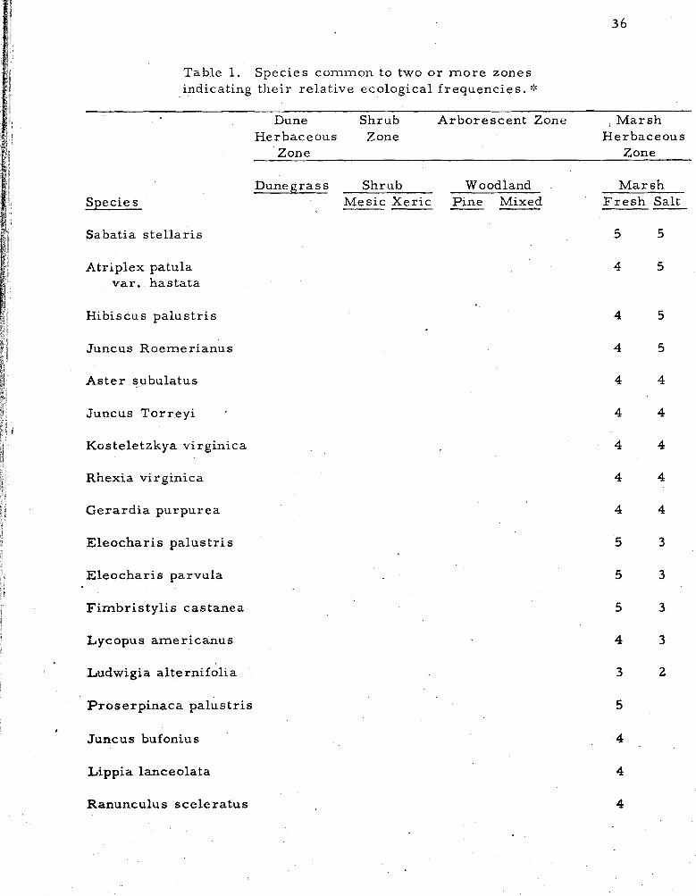
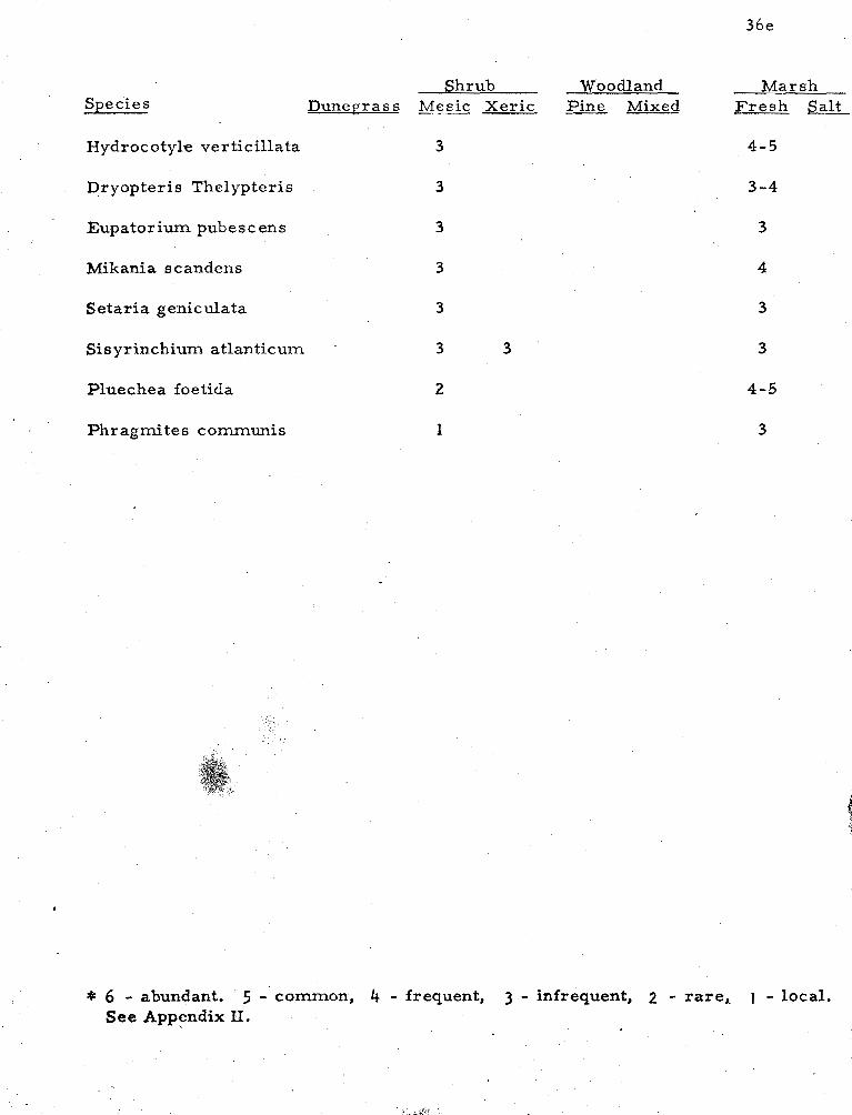
Table 1. Species common to two o r m o r e zones indicating their re la t ive ecological f requencies . :%
Species
Dune Shrub Arbore scent Zone I Marsh Herbaceous Zone Herbaceous
Zone Zone
Dunegrass Shrub Woodland Mesic Xer i c Pine Mixed -- - -
M a r s h F r e s h Salt
Sabatia s t e l l a r i s 5 5
Atriplex patula va r . ha s tata
Hibiscus pa lus t r i s
Juncus Roemerianus
A s t e r subulatus
J u n c u s T o r r e y i - t
Kos teletzkya virginica
Rhexia virginica
Gera rd i a purpurea
1 Eleochar i s pa lus t r i s
E leochar i s parvula
F imbr i s ty l i s castanea
Lycopus amer icanus
Ludwigia a l te rnifolia
P rose rp inaca pa lus t r i s
Juncus buf oniu s
Lippia lanceolata I
Ranunculus sce le r a tu s I
Species Dunegrass Shrub Woodland Mesic Xeric Pine Mixed ----
Centella e rec ta
Ludwigia palus t r i s
Ruppia mar i t ima
Potomoget on pectinatus
Potornoget on pusillus
Ascyrum Hypericoides
Elephantopus tomentosus
Liquidambar Styraciflua
P e r s e a Borbonia
Habenaria criskata
Myrica cer i fe ra
Myrica pensylvanica
Smilax glauca 5 5 5
Andsopogon virginicus 2 5 4 3
Prunus serot ina 5 3 4
Pinus Taeda 2 4 6 5
Sassa f ra s albidum
Smilax rotundifolia
Rhus copellina
* ~ a r t h e n o s i c c u ' s quinquefolia 4 4 4 4
Marsh F r e s h Salt -
Ilex opaca 4 4 4 3
Eupatorium rotundifolium 4 4 4 3
Rubus cuneifolia 4 4 . 3
Species
Vitis rotundifolia
I Quercus nigra
Quercus falcata
Uniola laxa
Acer rubrum
i 1
Juniperus virginiana 1
Nyssa sylvatica
Cir siurn horridulum
Salix nigra
Magnolia virginica
Campsis radicans
Gnaphalium purpur cum
Eupatorium capellifolium
i t Lonicera japonica /I I f Aris tida tuberculosa h
1 i Krigia virginica
l I
Panicum s c oparium li i a Andropogon scoparius i
I 1 7 Eupatorium hys sopifolium I j / ! Gaylussacia baccata iI
Vacciniurn a trococcum
;I ii& Smilax Bona-nox 1 4 L-Cchea Leggettii
Species
Hypericum gentianoides
Linaria canadensis
Shrub Dunegrass Mesic Xeric --
Polygonella articulata 4
I! Opuntia humifus a 3 il 'I
Osmunda regalis 3
I Mitchella repens 2
j! Vaccinium corymbosum 1
/ j I I
Distichlis spicata E,
Festuca rubra 4 4-5 Ij j! (
Festuca odna i
I 1 var . durius cula
1 1
t Rumex Acetocella
Vulpia octaflora 4 4
I Holcus lanatus 3 2 / i
1; Panicum dichotomif lor urn 2 3 r 6 I var, dichotomiflor&n & 9
Rubus flagellaris 3 3
P, lanuginosurn 2 3 var . Lindheime r i
Ammophila breviligulata 6 2
Solidago tenuifolia 4 4 4
& X Mollugo verticillata k * &: 11 Polypogon rnonspeliensis 3 3 . i. :1 I *
Woodland Pine Mixed
Cakile eden'tula I
Salsola Kali
Shrub Dunegrass Mesic Xeric --
Suaeda linearis 2
Atriplex arenaria 3
Panicum amardum and 2 -3 P. amarum
Hydrocotyle umbellata 2 t
:I $ Scirpus americanus 4 3 3
i Solidago s empervirens 5 5 3-5 / j Spartina patens 5-6 4 3 -4
Stropho s tyles helvola 2 3
Rhus radicans 3 5-6 5
Panicurn virgatum 3 3 4
Baccharis halimifolia 5 5
1 Iva frutescens 4 4
Teucrium canadense 3
1 Juncus a c d n a t u s 1 3-4 I I Oenothera fruticosa 3 i
I ConvolvuIus s epium 2 I i E Carex Longii 3 I i 1 Juncus dichotomus 4 t I L Juncwes scirpoides 3 E I 1 Ptilirnniurn c apillac eum 3 I I
Woodland Marsh Pine Mixed -- Fresh Salt
3
Shrub Woodland Marsh Species Dunegrass Mesic Xeric Pine Mixed Fresh sa l t
Hydrocotyle ver ticillata 3 4-5
Dryopteris Thelypteris 3 3-4
Eupatorium pubescens 3 3
Mikania scandens 3 4
Setaria geniculata 3
Sisyrinchiurn atlanticum . 3 3
Pluechea foetida 2
Phragmites comrnunis
* 6 - abundant. 5 - common, 4 - frequent, 3 - infrequent, 2 - rare,, I - local. See Appendix II.
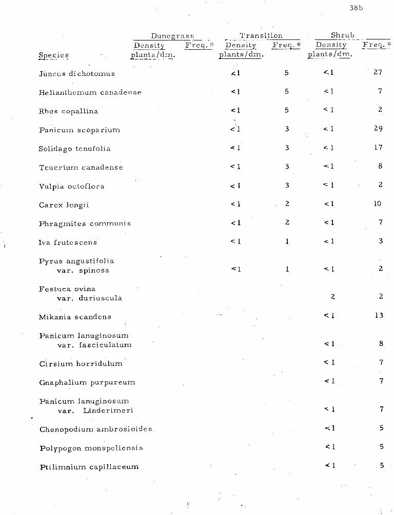
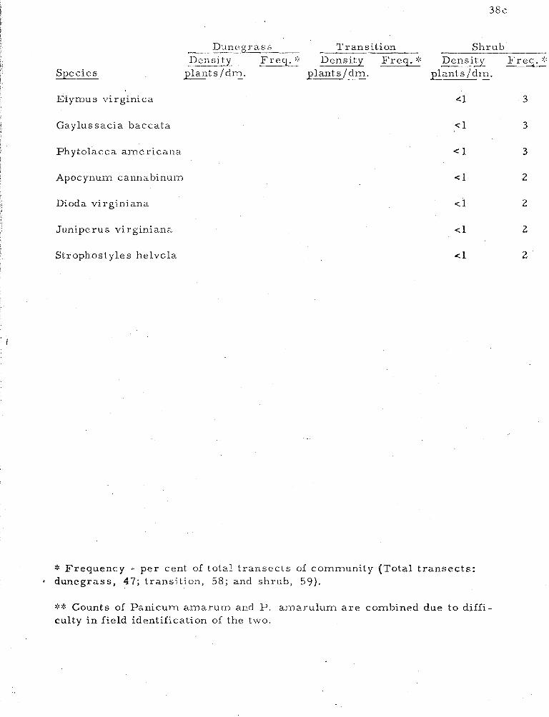
Transects . Species frequency and density, a s determined by
line t ransects in dunegrass, transition and shrub communities, a r e
shown in Table 2. A total of seventeen species occur in the dunegrass
community--most of them with a density of l e s s than one individual per
decimeter. This reflects the low cover value of the ent ire community.
Rarely i s the total cover in this zone over 20%. Of the seventeen
species here, fourteen, or 82% a r e a lso present in the transition zone.
The transition zone has forty-nine species. Of these, 7770
occur i n the dunegrass o r mesic shrub zones; the remainder a r e
typical of the xer ic .shrub community. Mesic shrub zone species a a
number forky-five; of the'se 6870 also occur in the transition or dune-
g rass zones.
The species which show the highest density a lso provide the
most cover. Of the sixty-eight species making up the three zones,
only seventeen species, o r 250/0, have a.density grea ter than one plant
pe r decimeter-- two in the .dunegrass community, seven in the t rans i -
tion zone, and eight in the shrub community. A m e r e five species
provide mos t of the total cover for the three zones: Ammophila
breviligulata, Myrica cerifera, M. - pens ylvanica, Solidago sempervirens,
and - Rhus radicans. These species a lso have the grea tes t frequency
values. In these t ransects , species that occur in only one zone provide
li t t le cover. T.hey al l have a density of l e s s than one with two
exceptions: Vitis rotundifolia in the transition zone, and Festuca ovina
in the shrub community.
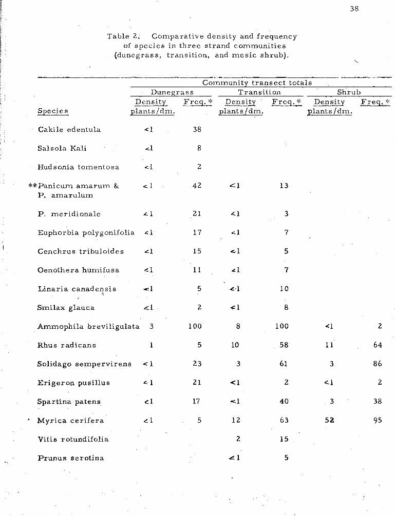
Table 2. Comparative density and frequency of species in three strand communities
(dunegrass, transition, and mes ic shrub).
Community t ransect totals Dunegrass Transition Shrub
Density Freq . * Density F req . * Density F req . ::: Species plants /dm. ~ l a n t s / d m . plants /dm.
Cakile edentula
Salsola Kali
Hudsonia tomentosa /I I! **Panicurn amaruin & cr, 1 4 2 1 P. arnarulum t i ii P. meridionale L 1 21
Euphorbia polygonifolia L 1 1 7
'I , Cenchrus tribuloides ~1 15 el ! j
I . r Oenothera humifusa e l 11 4 1
Smilax glauca .cl 2 41
Ammophila breviligulata 3
Rhus radicans
Solidago sempervirens 1
Erigeron pusillus 4 1 21 (1
Spartina patens c1 17 <l
* Myrica ce r i f e ra
Vit is rotundifolia 2
P runus serot ina -L 1
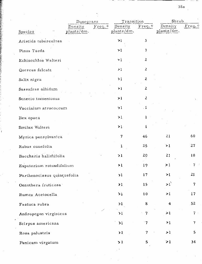
Dunegrass Trans i t ion Shrub Dens- F r e q . :: Density F r e q . * Density -- F r e q . ::
Species plants / dm. p lan ts /dm. plants /dm.
Juncus dichotomus ~1 5 Cr-1 27
Khus copallina
Panicum scopar ium
Solidago tenufolia
Teucr ium canadense c 1 3 - < r l 8
Vulpia octoflora c 1 3 < 1 2
Car ex longii
Phragmi te s communi s c 1 2 < 1 7
Iva f ru t e scens
P y r u s angustifolia v a r . spinosa
Feslzuca ovina v a r . dur iuscu la
Mikania scandens
Panicum lanuginos uin v a r . fasciculatum
C i r s i u m horr idulum
Gnaphalium purpureum
Panicum lanuginosum va r . L inde r imer i -C 1 7
Chenopodium ambros io ide s q l 5
Polypogon monspel iensi s
P t i l imnium capillaceurn
Species
Duncgrass --- Transition Shrub DcnsiQ - - 1: Density Freq . ::: Density Freq . :::
plants /dm. plants/dm. plant s /dm.
1
Elymus virginica 4 1 3
Gaylus sacia baccata
Phytolacca alnericalla
Apoc ynum cal~nabinuln
Dioda vi rginiana
Juniperus vi rginiana
Strophostyle s helvola
* Frequency - per cent of total t ransec ts of community (Total t ransec ts : dunegrass, 47; transition, 58; and shrub, 59).
** Counts of Panicum amarum and P. amarulum a r e combined due to diffi- culty in field identification of the two.
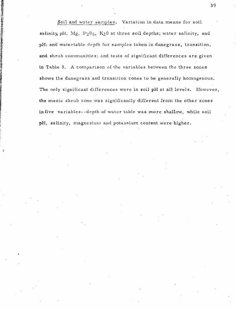
Soil and water samples. Variation in data means for soil
salinity, pH, Mg, P2O5, K20 a t three soi l depths; water salinity, and
pH; an'd watertable depth for samples taken i n dunegrass , t ransi t ion,
and s h r u b co~nmuni t ie s ; and tes t s of significant differences a r e given
in Table 3 . A comparison of the var iables between the three zones
shows the dunegrass and transit ion zones to be generally homogenous.
The only significant differences were in soi l pH a t all levels. However,
the mes ic shrub zone was significantly different from the other zones
inf ive variables--depth of water table was m o r e shallow, while soi l
pH, salinity, magnesiurrl ancl potassium content were higher.
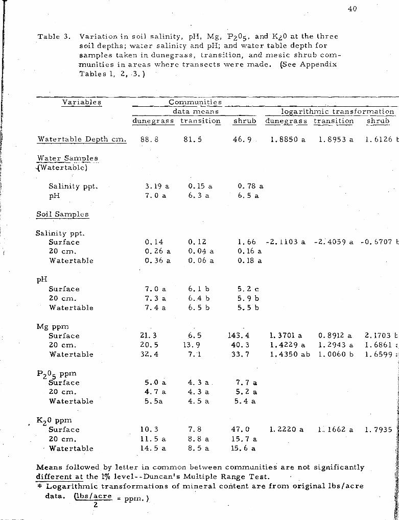
Table 3. Varia t ion i n soi l sal ini ty, pH, Mg, PZO;, and KLO a t the t h r e e so i l depths; water sa l in i ty and pH; and w a t e r table depth fo r s amp le s taken in dunegras s , t ransi t ion, and m e s i c s h r u b c o m - muni t i es i n a r e a s whe re t r a n s e c t s w e r e made . (See Appendix Tab l e s 1, 2, 3. )
Variable 5 Communit ies da t a m e a n s logar i thmic t rans format ion
duneg ra s s t rans i t ion s h r u b duneg ra s s t rans i t ion s h r u b
Water table Depth cm. 88. 8 81. 5 46. 9 1 . 8 8 5 0 a 1 . 8 9 5 3 a 1 .6126 b
i Water Samples a 4Water table)
1 Salinity ppt. 3.19 a 0.15 a 0.78 a I I PH 7 . 0 a 6 . 3 a 6 .5 a
I I Soil Sample s 9
t Salinity ppt.
Sur face 0. 14 0 .12 1 .66 -2.1103 a -2..4059 a -0. 6707 20 c m . 0 .26 a 0.04 a 0.16 a Water table 0. 36 a 0 .06 a 0.18 a
PH Sur face 7 .0 a 6 .1 b 5 . 2 c 20 cm. 7 . 3 a 6 . 4 b 5 . 9 b Water table 7 . 4 a 6 . 5 b 5.5 b
M g PPm Sur face 21. 3 6 .5 143.4 1. 3701 a 0.8912 a 2.1703 20 c m . 20.5 13. 9 40. 3 1.4229 a 1 .2943 a 1 .6861 Water table 32.4 7 .1 33.7 1 .4350 a b 1.0060 b 1.6599
P205 PPm Sur f ace 5.0 a 4. 3 a 7.7 a 20 cm. 4.7 a 4. 3 a 5 . 2 a
1 ." Water tab le 5.5a 4 . 5 a 5 .4 a j s
, K20 PPm Sur face 10 .3 7 .8 47.0 1.2220 a 1.. 1662 a 1 .7935 20 cm. 11.5 a 8 . 8 a 1 5 . 7 a Water tab le 1 4 . 5 a 8 . 5 a 15.6 a
Means followed by l e t t e r i n common between communi t i es are not significantly d i f fe ren t at the 1% level- -Duncan 's Multiple Range Tes t . * L o g a r i t h m i c t r ans fo rma t ions of m i n e r a l content a re f r o m original l b s / a c r e
data. Q i ~ s l a c r e . pp,a ) 2
The timing of the st!-idy proved to be fortuitous. At the
beginning, in 1965, the island was essent ia l ly dese r t ed . Only an
occasional f i sherman o r the few cottage owners w e r e t h e r e . By the
spr ing of 1968, the en t i re island, with the exception of the Wildlife
Refuge, was open to the public and general ly gccessible by automobile.
It is now a c a m p e r ' s haven and tou r i s t ' s delight. However, the
d i r ec t effect peop1.e wil l have on the vegetation general ly will be
l imited to the dunegrass zone. The other zones a r e protected during
f ros t - f r ee months by a population of voracious mosquitoes.
F lo r i s t i c s . Interzonal and intrazonal f lo r i s t ics and vegetational
zones in dune and sa l t m a r s h habitats have been documented many
t imes . Oosting (1954) notes that the wor ld ' s s eacoas t s are covered
with a vegetation of s i m i l a r life form--of ten of the s a m e gene ra and
occasionally of the s ame species . This is t r u e of the a r e a studied,
Assateague Island,and i t s neighboring s t r ands . Catalogues of the vege-
tation of the Outer Banks of North Carolina (Burk, 1961), Cape Henry,
Virginia (Egler , 1942) and Island Beach, New J e r s e y (Martin, 1959) a r e
cited to r ep re sen t f lo ras to the north and south of Assateague. E a r l i e r
papers a r e of l i t t le value a s they l i s t only isolated o r notable spec ies . I
A compar i son of the vascula r plant fami l ies collected on the
four b a r r i e r beaches i s shown in F igure 1. Of 108 fami l ies r e p r e -
sented, 50 a r e present in a l l four a r e a s . Assateague i s a t ransi t ion
bar between the southern and nor thern s t rand f loras ; however, i t inc-
cludes m o r e southern famil ies than northern. The one family found
only on Assateague, and not on the o thers , Lardizabalaceae i s r e p r e -
sented by one spec ies , Akebia quinata. This plant is a native of Asia ,
and undoubtedly was introduced on the island where i t i s now well
established a t one station nea r the Light house.

1. Dune Herbaceous Zone.
Beach. P ioneers along the upper beach a r e the same species ,
n o t e d for sal t tolerance, found in the low sal t m a r s h e s and pans. Most
prominent i s Cakile edentula--the only indigenous Crucifer on the
strand. The reproductive survival mechanism of' these species i s
an extravagant seed production, although seedling survival r a t e i s low.
This i s in marked contrast to the dune g r a s s e s which reproduce pr i -
mar i ly by vegetative means.
Beach plants survive only in the she l te r of driftwood o r smal l
dunes which build up along the upper beach. The habitat i s ve ry un-
stable; species a r e continually covered and uncovered by shifting sand,
and subjected to wind-driven sal t spray resulting in few matu re indi-
viduals. Along the ar t i f ic ial b a r r i e r dune bordering the upper beach,
the same species grow luxuriantly. This dune has been planted with
Ammophila breviligulata and fer t i l ized, and thus provides a m o r e
stable 'habitat a t a higher nutrient level.
Dunegras s Communit y. Ammophila breviligulata i s doininant
in the dunegrass zon'e behind the open beach. It i s common to a l l
ba r r i e r bars on.the Atlantic Coast, together with i t s assoc ia te , Spartina
patens. While the la t ter i s common in m a r s h e s and pans also,
A. breviligulata i s res t r ic ted to the dunegrass zone. Solidago - sempervi rens i s prevelant along the coas t in this zone, providing 10%
of the total community cover . F r o m North Carolina southward,
S. semperv i rens var . mexicana i s m o r e common. Panicum amarulum - -
and - P. a m a r u m a r e both widespread inembers of the dunegrass com-
munity on Assateague and the m o r e southerly bars . - P. amarulum
apparently approaches i t s nor thern l imit h e r e s ince Mar t in (1959)
r epor t s only P. a m a r u m in New J L r s e y , in associat ion with , - -- Hudsonia tomentosa on stable dunes, not in the dunegrass zone.
Arenar ia peploides, found a t two stations in Virginia, approaches i t s
southern l imit on Assateague. It has been recorded a s f a r south a s
Cape Henry, but colonies a r e few (Smith, 1940). Severa l spec ies a r e
conspicuously absent. Artenl is ia Stel ler iana Bess . , which i s frequent
on the neighboring s t r ands does not occur on Assateague. Ca rex
kobomugi Ohwi, present on Cape Henry and successfully introduced on
Island Beach does not occur. Two common southern species reported
a t Cape Henry apparently reach their nor thern l imi t just south of
Assateague. Uniola paniculata L., an important dune binder, is not
present , no r i s - Iva imbr ica ta Wilt. , a f o r b frequent f r o m Cape Henry
south.
Man now recognizes the importance of holding sand on the
b a r r i e r beaches against erosion, and the importance of vegetation a s
a sand s tabi l izer . On Cape Cod at tempts w e r e made to stabil ize dunes
with plantings a s e a r l y a s 1892, but only recent ly has the re been con-
s t ruct ion of ar t i f ic ia l b a r r i e r dunes along the shorel ine, par t icular ly
since a d isas t rous s t o r m in 1962. These dunes a r e built para l le l to the
ocean, landward of the high tide l ine, thus, within the dunegrass zone. i
\
The dune reduces sand accre t ion and sa l t sp ray behind i t and
4 6
i nc reases both fac tors on the windward s ide. The community landward
will show the f i r s t effects of this b a r r i e r dune- -par t icu la r ly the broad
expanses of Ammophila breviligulata. Wagner (1964) has shown that
th is spec ies r equ i r e s sand accumulation in o r d e r to surv ive . When I I
this i s reduced, the d u n e g r a s ~ ~ c o r n m u n i t y will be replaced, probably
by the sh rub community of stable secondary dunes, Long-range
studies of a r e a s behind <the new b a r r i e r dunes would provide some
evidence of the direct ion of, o r fac tors affecting, success ion on dunes.
One genera l cha rac t e r i s t i c of the dominant m e m b e r s of the
dunegrass community, previously noted, i s that these spec ies r e p r o -
dyce mos t successfully by underground vegetative means- -not by seed.
The perennating ox-gans overwinter underground where they a r e pro- i
tected f r o m sal t sp ray during the period of highest s a l t deposition.
Most of the spec ies have deep rhizomes which spread under the sand
or, a s i n the r a s e of Solidago semperv i r ens , immatu re l a t e r a l under-
ground shoots. Laing (1958) showed that ~ m m o ~ h i l a - brevil igulata,
which reproduces effect ively by runne r s and fragmentat ion, a l s o p ro -
duces l a r g e numbers of s eeds of which only 5% a r e viable. Oosting
(1954) found that Quercus virginiana, growing where s a l t s p r a y i s
highest in the a rbo rescen t zone, has low seedling survival .
In a comparison study of four populations of Polygonum
bistortoides P h r sh.) Moone y (1963) found that the coas ta l population
reproduced only by rhizome proliferation, while the alpine populations
s e t viable seeds , and showed no vegetative reproduction. Salinity
conditions of the coastal population were not reported. Nobuhara (1967)
stated that "coastal plants cannot live on the coast without the power of
developing new overground shoots when covered by sand". The mos t
successful plant spec ies in regions of high sa l t spray general ly ove r -
winter and reproduce vegetatively underground, where the effects of
sa l t s p r a y a r e minimal .
The few species in the dunegrass zone which reproduce by seed
a r e a l so found in low sa l t m a r s h e s and pans. In the two l a t t e r com-
munities, seed reproduction i s m o r e common. One m a y postulate that
the inability of seeds o r seedlings to survive i s a factor l imiting the
number of spec ies i n a r e a s of high a e r i a l sa l t spray , whe reas i t i s
not a factor where the sa l t i s in the soi ls and ground water alone.
2. Shrub Zone.
On Assateague, Myr ica ce r i f e r a i s dominant in the sh rub zone,
m o r e plentiful in m e s i c si tuations than in xe r i c . It i s one of the few
plants Latrobe (1798) l isted a s presen t on Cape Henry; however, i t i s
not included in E g l e r ' s (1942) l is t . Snow (1913) reported that, although
Maryland i s considered the nor thern l imit of - M. ce r i f e r a , i t had been
recorded in Delaware by Williamson (1909) and in New J e r s e y by Stone
(1910). Mar t in (1959) did not locate i t on Island Beach. However,
Stoesz and Brown (1957) stated that - M. ce r i f e r a has been successful ly
planted on Cape Cod, Massachusetts , in dune stabil ization work. The '
Myrica c e r i f e r a community on Assateague i s perhaps pecul iar to the
coas t nor th of the Outer Banks. The descr ipt ion of the sh rub zone of
the Outer Banks did not separa te mes ic and xe r i c shrub communities,
but the dominants of the &one, - M. c e r i f e r a and - M. pensylvanica, a r e
"fairly common" (Burk, 1961). Other species of the Outer Banks a r e
predominantly southern species: Quercus virginiana and Ilex vomitoria
Ait. Although M. cer i fe ra does not occur a t Cape Henry, .
M. pensylvanica i s common but not dominant there , associated with -
Quercus virginiana.
Vaccinium corymbosum dominates the Island Beach m e s i c
thickets and - M. pensylvanica occurs a s a subdominant. Other than
these principal differences f rom the Assateague thickets, the sub-
dominant shrubs and lianas a r e the same in both places. On Island
Beach there a r e tangles composed ent i rely of Smilax spp.. Although
Smilax i s prevalant on Assateague, it has not made a community
1 excluding other species.
Juniperus virginiana i s a subdominant on the two southern bars;
in New J e r s e y i t i s abundant and fo rms extensive fores ts . According
to Martin (1959) i t i s the "most abundant t r e e on Island BLach t l .
ig Although i t i s present ' in a l l vegetative zones on Assateague, except the
m a r s h e s , ma tu re plants a r e infrequent to r a r e . Numerous seedlings
occur--part icular ly in one pan edge which was recently dyked to p re -
vent flooding. Since Juniperus virginiana i s a ma jo r species in the
other three bars , i t s e e m s s trange i t i s not s o on Assateague. Another
species , Chamaecyparis thyoides (L. ) BSP i s common on s t rands both
north and south, but not found on Assateague.
i
The xe r i c shrub community frequently includes Pinus Taeda
and deciduous t r e e species found in the woodlands; m o r e than a r e com-
mon t[o both the mes ic shrub and woodland communities. Table 2
shows that few species a r e present both in the t ransi t ion zone and
mes ic shrub community. More of the transit ion zone species a r e
common to the xer ic shrub community. If succession i s taking place,
the progression i s probably f rom dunegrass to xe r i c shrub to woodland.
The mes ic shrub community represents a var iance f r o m the normal
topographic up-building process of secondary dunes.
3. Arborescent Zone
Mari t ime forest . The maritirr.e fores t a s descr ibed by Oosting
and Bourdeau (1959) has not been defined on Assateague. No community
s imi lar to the live oak fores t on the Outer Banks o r the cedar thickets
on Island Beach occurs here.
Pine woodland. The pine woodlands on Assateague, on high
secondary dunes, occurs between the shrub zone and the sal t m a r s h ,
but much elevated above the la t ter . The dominant i s unquestionably
Pinus Taeda- -often in pure stands, but occasionally mixed with oaks.
I t i s dominant a l so on s t rands to the south, but not present to the north
on Island Beach. - P. rigida Mill. i s the dominant pine in New Je r sey ,
but, as previously mentioned, Juniperus virginiana i s generally the
m o r e common t r e e .
Egler (1942) postulates f i r e a s the mos t important single factor
prepetuating pine, indicating i t i s a subterminal stage of succession.
Burk (1961) believes the presence of pine fo re s t s i s due to excess
logging of hardwoods, and the difficulty of smal l an imals in t ravers ing
the ~ a k k s which consequently prevents reforestat ion by seed they
c a r r y . The pine woodlands in the Maryland portion of Assateague, in-
cluding s i tes of previous logging, a r e h a r e a s where the island juts .
out into the bay. They are made up of old t r e e s on stable dunes. The
progress ion of pine to deciduous woodland i s difficult t o determine, but I
i t appears these t r e e s will be undercut f r o m the bayside and the wood-
lands become sa l t m a r s h before conditions change sufficiently to p e r -
m i t formation of a pine-deciduous mixture , o r a deciduous woodland. 1 I Ij
The presence of shrub and pine vegetation in hummocks within the sa l t i
m a r s h demonst ra tes the possible advance of the m a r s h into a woody
community . The Virginia portion of the island i s generally wider and the
woodlands m o r e extensive than a t the nor thern end. At tfie widest
point, the pine woodland i s much the s a m e composition a s that d e s - ll c r ibed on Cape Henry (Egler, 1942). The unders tory i s composed of
Magnolia virginiana, P e r s e a Borbonia, I lex opaca, and Vaccinium spp.. i - { i f
The fact that this pine woodland was cut over and fa rmed until 1930, ! il
* b
m a y account for i t being the only such associat ion on the island. t
i I
Pine Deciduous Mixed Woodland. The pine deciduous mixed y 1
woodland on Assateague occur s on the high dunes in the a r e a of the I Light house. Three species in this woodland w e r e not found elsewhere 1 on the island: Cornus f lor ida (one specimen), Xanthoxylum clava- , I hercul i s (one specimen - i t is frequent on ba r s to the south and
and possibly reaches i t s nor thern l imit h e r e ) , and Berchemia scandens
(an extensive growth in one small a r e a ) .
'oaks associated with the pines v a r y along the coast . In North
Carol ina and Virginia, the m a j o r spec ies a r e Quercus fa lcata ,
Q. nigra , and Q, visginiana. On Assateague, Q. virginiana i s not - - - present , but the o ther two a r e colnmon. In New J e r s e y , nei ther
Q. nigra o r - Q. virginiana a r e presen t , while Q. fa lcata i s s t i l l corn- - rnon (probably at$ its nor thern l imi t ) , in associat ion with - Q. il icifolia
Wang. and - Q. mari landica Muench.. Carya spp. range f r o m presen t
to dominant on the southern ba r s , but a r e not p re sen t on Assateague
o r Island Beach.
A c e r rub rum is aryimportant species i n m e s i c si tuation on all
b a r s except the Outer Banks. In New Je r sey , i t i s dominant i n wood-
i lands on the mainland where the water table i s high (Bernard, 1963). i
'1, P r e s e n c e of A. rub rum in swales of the m o s t s table pine-deciduous I \
(il community indicates i t may be the t e rmina l o r sub te rmina l s tage of 1 \ 1
l1 succession in the mes i c community. -Harv i l l (1967) descr ibed the 1 1
11 - A. rub rum community on Assateague a s an assoc ia t ion of - A. rubrum, I '
I' I l Quercus n igra and N ~ q s a sylvatica. However, th is author found but I
I I I one specimen of Wyssa sylvatica i n the a r e a , hard ly enough to qualify
1: i t as a m a j o r component of a-community. The m o s t frequent assoc ia te 1 I j l $
with A. rub rum and Quercus nigra is S a s s a f r a s albidum. , - On all b a r r i e r is lands, the a rbo rescen t zone occu r s on the
la rges t s table secondary dunes and intervening swales f a r thes t away
f r o m the ocean. The dunes a r e formed f rom sand ca r r i ed by the on-
shore prevailing winds. Oosting (1954) s ta tes , "Often highest dune
ridges in an a r e a a r e the resul t of an extensive blowout which piles
quantities af sand above the already established surface level. . These
a r e important because of the protection provided leeward. This p r o - I I
I tection permits conditions suitable to fo res t development, but then the
fores ts a r e continually being covered by dunes pushed landward by
the onshore winds.
Latrobe (1798) described a swamp overgrown with aquatic t r e e s
and shrubs on Cape Henry a s follows: "Of these, many thousand a r e
already buried in the sand, which overtops their summits , and
threatens the whole fores t with ruin. Their destruction i s slow but
inevitable. The same phenomenon i s s t i l l occurring on ba r s a l l along
the coast, and has been recorded often.
Evidence of previous vegetative zones i s difficult to discern.
The presence of Quercus falcata in dunegrass and transition zones may
indicate fo res t s which have been covered by encroaching sand.
Q. falcata he re i s very low (often not over one me te r ) , but spreading, - covering an a r e a of two-meter diameter--possibly the crown of an old
tree. The fact that there a r e nb s imi lar pines may indicate pine does
not survive sand coverage.
Oosting (1954) and Burk -(1961) reported "ghost fo res t su - - s tumps
surviving in the ocean inter t idal zone--on the Outer Banks. One such
"foresttf occurs on the surf a t Green Run on Assateague. The presence
of these "forests" clear ly indicate that woodlands were located far ther
eastward than they a r e now. One can only judge by our present
knowledge of zonation, that the dunegrass and shrub zones were
present eas t of the beach where the stumps a r e now located. Mzterial
f r o m one stump on Assateague has been identified a s a "hard pine":::,
presumably - P. Taeda. In light of the present vegetation of the island,
i t s eems logical that this was a pine fores t r a the r than cedar (as the
stumps a r e called b y local residents ), and would eliminate the
possibly of an extensive cedar fo res t on Assateague within recent time.
Mar t in ' s postulation (1959) of succession i s applicable on
Assateague. s tates that the terminal stage of succession i s de te r -
mined by environmental limitations of the area. .* The northern portion
of Assateague i s neither wide enough, nor the dunes high enough to
provide the protection f rom salt spray required to permit establ ish-
ment of a hardwood forest . The pine-deciduous mixture a t the widest
portion in Virginia demonstrates that hardwood fo res t s can establish
themselves on Assateague where conditions permit . The presence of
deciduous t r ee species in zones closer to the ocean indicate isolated
a r e a s affording enough protection for them to survive.
4. Marsh Herbaceous Zone.
Salt marsh . The present study of the salt m a r s h verif ies the
* Persona l communication W. L. Stern, Wood Anatomist, University of Maryland. >
findings of other investigators. The marshes of Assateague show the
s a m e mosaic pattern described in ea r l i e r l i terature. Species a r e
separated generally into the low m a r s h and high marsh , but any change
in elevation i s sufficient to a l te r the edaphic conditions, including
daily inundation, and produce a distinct change in species within either
marsh .
Spartina alterniflora, character is t ic of low m a r s h on other
s t rands , i s not common on Assateague. It occurs a s a narrow band on
the m a r s h bayside. Spartina patens, a high m a r s h species , covers
many a c r e s i'n pure stands--providing the "salt hay1( on which the 4
Assateague ponies graze. Species common to the pans appear a lso in
the low marsh: Atriplex patula, Cakile edentula, Salicornia spp. , and
Suaeda l inearis .
Borrichia frutescens, common on southern strands, was found
along the shore of Tom's Cove--two stations only. A single specimen
in the University of Maryland Herbarium i s labeled "North Beach fe r ry
landing, Assateague ~s land : Maryland, " and dated 1948. A specific
search in this vicinity and other s imilar s i tes failed to reveal i t s
presence in 1967. This may indicate the l imits of the range a r e
decreasing. The northern limit of the species on Assateague i s
probably now Virginia.
There i s insufficient evidence to indicate biotic succession in
the sal t marsh . The hummocks within the marsh having xeric shrub
f loris t ics might indicate succession, but i t i s more probable that they
a r e r e l i c s of a former shrub zone which has been replaced by marsh .
The theory advanced by Burk (1961) that the las t successional stage in
tidal m a r s h e s i s the Myrica cer i fera shrub community i s applicable
here .
Transec ts . Transec ts in the dunegrass zone show only 17
species. Two of the three species occurring only in the dunegrass
zone a r e well-known halophytes, Cakile edentula and Salsola Kali.
These a r e also found in sal t pans and sal t marshes . The third species
(Hudsonia tomentosa), which i s ra re ly found in the dunegrass zone, i s 0 *
a dominant on stable secondary dunes. Possibly this one i s a rel ic of
a fo rmer secondary dune. Ammophila breviligulata i s the dominant in
both the dunegrass community and the transition zone. The fact that
density i s higher i n the transition zone may. indidate m o r e favorable
growing conditions.
When this t ransect study was initiated, i t was assumed that the
shrub zone was represented by Myrica cer i fera o r M. pensylvanica. - The presence of one of these was used a s a cr i te r ion for locating shrub
a r e a s for t ransect sampling. It i s now recognized that, although both
Myrica species a r e represented i n the shrub zone, they a r e dominant
only in the hydrosere, although also present in the xe rose re . Thus,
shrub zone t ransec ts do not represent the ent i re shrub zone, but only
the mesic community within the shrub zone.
The Myrica species in the rnesic shrub zone obviously grow , <*\ i . /
undeG3conditions m o r e favorable than those in ei ther the transition
zone or the xer ic shrub community. The Myricas in the mes ic com-
munity a r e ta l ler and more vigorous, forming dense thickets, tlian
those of more xer ic habitats whi;dh grow singly and generally smal ler .
The presence of many species typical of the xe r i c shrub zone
in the transition zone, and the absence of those same species in the
Myrica thicket may indicate that khe Myrica thicket i s an interruption
of orderly transition between the transition zone and the xer ic shrub
community. On the other hand, it may be argued that the two pro-
gressions a r e occurring simultaheously, one in xer ic and one in
mes ic habitats. The xer ic communities dominate any zone.
Soil and soil water samples. The present study demonstrates
the fact that significant differsnces exist between the dunegrass and
mes ic shrub communities, and the transition zone between them. The
data indicate a difference in soi l nutrients between the xe r i c and mes ic
communities, in addition to the difference in moisture conditions.
The wide variation in the edaphic fac tors measured within each eom-
munity indicates that the species 'of that community tolerate a wide
range of these factors . At leas t in the dunegrass and t ransi t ion zones,
species exis t a t ferti l i ty levels which a r e agriculturally very low.
.The presence of minera ls in the dunegrass zone soi l i s not
unexpected with .the ocean constantly resupplying the dunes. The low I
level of nutrients in the transition zone.may be assumed due to the
position far ther away f rom the ocean. However, the high levels of
magnesium and potassium in the mesic shrub zone were not expected.
57
The position of this community i s behind the transition zone away
from the ocean and topographically low, ,thus making ocean supply
unlikely.
The high magnesium and potassium content. may be the . inter-
action of two factors . There i s considerably more organic ma t t e r on
the surface of the mesic shrub zone than the other two zones studied
here. Organic mater ia l has a tendency to hold both magnesium and
potassium, but not phosphorous. There must be a source of minera ls ,
however. Presumably i t i s f rom the bay, ra ther than the ocean. a .
Many of the mes ic shrub communities a r e adjacent to sal t marshes ,
o r contain inlets f rom the bay so that water may flow direct ly into
them, bringing into the community a regular source of minera ls .
Even if the community.is not directly connected to the bay, the water
table i s high and soil surface subject to flooding. Flooding provides a
means of circulating the minera ls f rom thesurface to the water table
and vice versa . . .
More work i s required to support this hypothesis. Originally
the thoughtbehind taking soi l and water sampl'es was mere ly to demon-
s t ra te the differences between what was assumed to be . three homo-
geneous zones. However, samples for each parameter within each
zone showed such wide variation, i t i s difficult to explain. Sites of
t ransects and pits were selected by the appearance of the community
present. Floristically, within each zone the samples were relatively
homogeneous. It was assumed that a l so edaphically they would be
relatively homogeiieous. However,*this i s not the case. A wide
difference in samples f o ~ each parameter withinteach f lor is t ic zone
indicates much variation of conditions within each zone. A m o r e
careful selection of s i tes within zones, reflecting their devel opmental
stage, ra ther than the f lor i s t ics could possibly shed light on this
anomylous situation. Such differences a s those between salinity of
soi l water in the dunegrass zone (3.19 ppt. ) and soil a t the s a m e point
(0, 36 ppt. ) certainly dese rves additional attention.
Succession. h 'Mar t in (1959) in a studious consideration of
succession concludes:
"In i t s 'b roader aspec ts , plant succession on Island Beach is controlled by oscillations in the interaction
t betwe,en physical and biotic forces . A m o r e prec ise description of successional patterns must necessar i ly await the accumulation of more prec ise data concerning the environmental and vegetational p rocesses involved. Even a t this stage of knowledge, however, i t s eems reasonable to conclude that plant succession of Island Beach, and perhaps on b a r r i e r beaches in general , is largely an intrazonal phenomenon. The herbaceous, shrubby, and arborescent zones do not necessar i ly represent sera1 s tages in biotic (autogenic) succession. The herbaceous zones [Dunegrass and Salt Marsh) a r e s t ructural ly and compositionally stable under the environmental conditions which charac ter ize them. Within the environmentally l e s s seve re shrubby, and arborescent zones, s eve ra l s e r e - xerose re , hydro- s e r e , and halosere - a r e recognizable, and the s t ruc ture of te rminal s tages i s determined by environ- mental limitations--especially salt sp ray intensity. "
L
This study of the vegetation of Assateague supports his con-
clusion. The evidence of biotic succession on Assateague i s incon -
clusive, but the same zonal pattern occurs here . However, the
presence of distinctly different xe r i c and mes ic s e r e within each
vegetative zone indicate two lines of succession. The vegetative
zones a r e commonly descr ibed b y the dominants of the x e r i c com-
munities (dunegra s s - Ammophila; shrub - Vaccinium-Myrica;
a rborescent - Pinus -due rcus ) because these occupy mos t of the s t rand.
The mesic society i s often no more than a minor mosa ic
within the xe r i c community, but i t a l so rangesfrom herbaceous to
shrub to woodland (fresh and sal t m a r s h - Sci rpus and Spart ina;
shrub - Baccharis-Myrica; a rborescent - Acer-Salix). The a r b o r - -- escent mes ic community i s probably a s stable a s that of the x e r o s e r e
under the prevailing environmental l imitations. This m e s i c l ine of pro-
gress ion a c r o s s the s t rand, although of' l e s s e r importance than the
x e r i c progression, should not be ignored; indeed i t should b e invest i -
gated fur ther .
In his discussion of causes of zonation on the s t rand , Oosting
(1954) accepts wind-borne sal t spray as the ma jo r factor , and l i s t s
other potential causative fac tors . In this study, two other fac tors ,
topographylas depth of water table) and mine ra l s in the soi l a r e con-
s idered between two vegetative zones. It i s shown that the depth of the
water table i s significantly c lose r to the sur face in the m e s i c sh rub
than in the dunegrass 'and transit ion zones, and that magnesium an,d
potassium a r e significantly higher in the mes ic shrub zone. Although
the differences a r e significant, m o r e study i s required before declar ing
these fac tors limiting o r causative in zonation.
It is generally accepted that on b a r r i e r b a r s successional
relationships "between vegetative zones i s stable if there i s no
change. However, any successional trend on a ba r r i e r
bar must be temporary, a s ' i t i s subjected to sand burial. Oosting
(1954) s ta tes: "Although mater ia l s may be added to the beach, . there i s
a tendency for mater ia l s to be removed and ei ther to be ca r r i ed inland
or car r ied away. Most banks, therefore, tend to become na r rower or 4 '
to be shifted inland under the influence of waves, cur rent and wind. I t
The effect of the ar t i f ic ial ba r r i e r dunes constructed along the Atlantic
coastline remains to be seen. Physiographic changes such a s redaced
sand burial, and sal t spray will resul t . The changes which follow may
indicate successional t rends in a shor te r t ime than would be required
naturally. .
On the dune strand habitat, zonation and succession cannot be
separated. The causative fac tors of zonation and those limiting
succession a r e the same. Any physiographic change on the s t rand
brings about a change in the plant community, and i t has been shown
that new communities may be of lower successional s ta tus a s often
6 1
APPENDIX 1
HISTORICAL AND GEOLOGICAL ASPECTS
Assateague Island i s par t of the b a r r i e r island sys t em along
the North American shore of the Atlantic Ocean. These islands a r e
initially composed of sand, although s i l t and organic ma t t e r a r e
accumulated la te r . Sands a re thrown up by ocean waves. As a wave
ro l l s shoreward a c r o s s the ocean, the oscillating water eventually
touches the bottom in shallow water , slowing the wave and creat ing a
drag. This moves the bottom mate r i a l s shoreward, init ially c rea t ing
/' the bar . Due to the fact that the prevelant wave action i s not continu-
/'
ally a t right angles to the beach, there i s l i t to ra l d r i f t - that i s - a
net long-shore movement of ma te r i a l , p r imar i ly sand. On Assateague
the direct ion i s south, hence a hook formed on the southern t ip of the
island, south of Assateague Cove, commonly known a s Tom's Cove.
Between the b a r r i e r islands and the mainland a r e lagoons,
designated locally and on cha r t s a s bays. These bodies of water a r e
by Pr i t cha rd ' s (1952) definition, es tuar ies - -specifically bar- built
es tuar ies . The bay between Assateague and the mainland to the north
1 i s the Sinapuxent Bay. To the south i s the Chincoteague bay, one of
the l a rges t (five mi l e s a t i t s widest par t ) and mos t important of the
Atlantic Coast (Vokes, 1961).
The Maryland ba r r i e r beaches a r e of Miocene s e r i e s , presently
E in an interglacial period when the ocean i s rising and the coastline sub-
siding (Vokes, 1961). Erosion and the subsiding coastline have pro-
I duced changes in the island s ize and location within his tor ic time.
The presence of a "ghost forest" , i. e . , stumps of coniferous t r e e s in
the surf at Green Run, now indicates the island has been wider there,
and probably along i t s ent i re length. Truitt (1968) postulates that
Assateague consisted of a s e r i e s of smal l islands which have coalesced,
forming the present bar.
In 1837, Ducatel described a feature of "that par t of Maryland which l ies on the Atlantic Ocean. It embraces the eas te rn side of the lowest Eas tern Shore county, (Worcester) the main land of which i s separated and protected f rom the surf , by a sandy beach, a t present, extending unbroken the whole length of the Maryland sea-coast . The intervening sheet of water is%own. as the Sinepuxent sound;. . . Here the process of filling up i s gradually going on, the m o r e rapidly since the inlets of the ocean into i t have 'become obstructed. . . Until lately the sandy beach just r e fe r red to consisted of a s e r i e s of islands, some of which were tolerably well wooded, a s those on the Virginia coast now a re . . . . I I
At present , Assateague Island i s a continuous bar extending
f rom southeast of Chincoteague Island, Virginia, to Ocean City,
Maryland. Until 1932, the bar extended into Delaware; however, a
na r row inlet was cut just south of Ocean City in 1929. A s t o r m in 1933
enlarged the inlet making i t navagable. Since then the Federa l Govern-
ment has maintained the inlet with stone jett ies. These jett ies have I 1
I ;
two effects. They keep the inlet open, and they increase the sand , , I accumulation a t Ocean City beach, while depriving the nor thern tip of I
I I Assateague of sand CSieling, 1960).
Inlets between b a r r i e r is lands provide a source of s a l t water
into the bays. Salinit ies in the bays behind Assateague a r e highest a t
the inle ts dur ing m o s t of the year . Seasonal fluctuations show lowest
sal ini t ies- -(24 O/oo)- - in March and Apr i l and highest- -(up to 38 O/oo)- -
due to evaporation in August and September . This i s higher than the
ocean which i s general ly 30. 5 O/oo (Sieling, 1960).
When s t o r m t ides over run low pa r t s of the b a r r i e r beach,
ocean wa te r s en te r the bays direct ly . On Assateague, th; s i t e s of
. previous inle ts a r e m o s t frequently inundated by abnormally high t ides.
However, with the construction of a n a r t i f ic ia l b a r r i e r dune in 1963,
m o s t of these w e r e closed to the ocean. Two a r e a s in the Maryland
port ion r ema in open to ocean s to rms : a low wash south of Green Run,
and the nor thern tip, both of which a r e quite low, a lmos t b a r r e n of
vegetation and frequently flooded. ,
Sieling (1960) s ta tes that sa l ini t ies i n the bays inc reased with
the opening of" the O c e a s 4 City inlet in 1933. Although he i s not specific,
he mentions that th is has changed the bayside f l o ra of the upper portion
of the b a r r i e r beach (pcean City to Delaware). P re sumab ly this would
be t r u e a l s o of the lower portion (Assateague Island). T ru i t t (1968)
has recorded opening and closing of five inle ts a c r o s s the presen t
island s ince the eighteenth century.
With the exception of two smal l , i solated a r e a s a t Green Run
and North Beach which a r e Norfolk'sand, and the t idal m a r s h e s , the
is land so i l i s . coas ta l beach sand- -a white to light g r e y sand continuing
down s e v e r a l feet . The t idal m a r s h so i l s a r e Elkton sandy loam- -a
grey medium sandy loam. The subsoil of the high t idal m a r s h i s a
heavy bluish-grey medium sandy loam where dra inage i s poor and
the water table i s n e a r the surface. In the low tidal m a r s h , the top
soi l i s mixed with muck, and the subsoil clay, covered with water
a lmos t continually p e r k i n s and Bacon, 1928).
The ea r ly effects of man on the p re sen t vegetation of Assateague
a r e not apparent ; however, the h i s tory of the is land indicates these
probably have been of some importance. Three vil lages w e r e built
a t Green Run, Pope Island, and As sateague Light. These w e r e s m a l l
communit ies of f i sherman, lumbermen and f a r m e r s which have d i s -
appeared in the la& century. The subsequent effects of lumbering o r
fa rming a r e not ea sy to de te rmine . Since a loblolly pine fo re s t can
m a t u r e in 25 years'(Cope, 1926), a r e a s changed by extensive cutting
may have been obli terated s ince the l a s t inhabitants left the island.
Grazing the sal t meadows of b a r r i e r is lands has been common
s ince the 1800's. The Outer Banks of North Carolina, and Cape Cod,
Massachuset ts , w e r e grazed continuously until they w e r e made National
Seashores recent ly by the F e d e r a l Government. The extent of grazing
on Assateague has not been recorded. Ducatel (1837) r epo r t s that , when
Assateague was a s e r i e s of separa te i s lands , the i s lands w e r e inhabited
by a r a c e of h o r s e s called "Beach ponies1'. However, in 1836, Ifonly
a few of these Beach ponies r ema in on the Virginia i s lands , having
been not many yea r s back a lmos t totally destroyed by a n inroad of the
ocean, to which these t r a c t s of land a r e natural ly exposed. I ' :Perk ins
and Bacon (1928) note that "the so i l of the inner border of the island
I
suppor.ts g r a s s e s which a r e forage for ponies, sheep, goats, hogs and I
catt le. I f A h e r d of about 150 ponies s t i l l g r aze the Spart ina m a r s h e s and I
I
woodlands within the Wildlife Refuge. They a r e owned by the ~ h i n c o - I
I
I '
teague Volunteer F i r e Department, a r e rounded up each July and the ,
spr ing colts sold.
It i s conceivable that lumbering and grazing, par t icu la r ly
grazing on the foredunes, removed sufficient vegetation to produce
blowouts, permit t ing l a t e r inle t format ion. One m a y wonder whether
vil lages w e r e built beside navagable inle ts , o r whether the activity
of the v i l l agers produced the inle ts .
B a r r i e r is lands 'are subjected to h a r s h environmental conditions.
The sands piled up b y ocean waves a r e exposed to landward e ros ion by
prevailing winds, par t icular ly during ocean s t o r m s . The va lue of
vegetation i n holding sands against e ros ion was f i r s t recognized i n the
United States on Cape Cod a s ea r ly a s 1828. Lamson-Scribner (1898)
desc r ibed the planting of sand with Ammophila brevil igulata (erroneously
named Ammophila a r e n a r i a a t tha t t ime) i n 1895. By 1898 "no sand has
moved" in the planted a r e a s , and t r e e and sh rub seeds planted s ince
1895 were growing- -on sands encroaching on the town of Provincetown
and i t s harbor . Since that t ime considerable dune building and s tabi l i -
zation has been c a r r i e d out on Cape Cod. On numerous b a r r i e r b a r s
along the Atlantic coast , the National P a r k Serv ice has constructed
a r t i f ic ia l b a r r i e r dunes- - these are bulldozed piles of sand, ten to
fifteen feet high, reinforced with sand fence on top to collect drifting
sands, and planted with Ammophila breviligulata. These dunes have
proven effective in preventing the ocean f rom washing a c r o s s the is lands
during s torms.
On Assateague, since 1943, the United States Department of
Inter ior F i s h and Wildlife Service has maintained a Wildlife Refuge
covering most of the, Virginia portion of the island. In 1963, they con-
s t ructed a b a r r i e r dune f rom Green Run to the southern tip of the I I I
island. Port ions of the Maryland end a r e a l so protected by ar t i f ic ial
ba r r i e r dunes, some built by private in te res ts , th ree mi l e s a r e main- i
I
tained by the Maryland State P a r k Service. The National P a r k Service 1 J d 1
i s current ly acquiring the remainder of Assateague for a National 3
Seashore. They undoubtedly will complete the b a r r i e r dune. The a r t i -
f icial dunes will reduce sand movement and sal t spray ca r r i ed a c r o s s I
the strand. This should help stabilize the p r imary dunes behind them,
and have an effect on the plant communities. Presumably the new con-
ditions will permit species l e s s sal t tolerant and l e s s able to with-
stand sand accret ion to enter new a r e a s .
The Wildlife Refuge management i s pr imar i ly interested in
migra tory waterfowl. Within their a r e a giant impoundments have been
established to maintain aquatic plants, and l a rge fields of mil le t have
been planted a s sources of duck food. The ilnpoundments present a
habitat unusual on the s t rand-- la rge expanses of f r e s h to brackish
standing water.
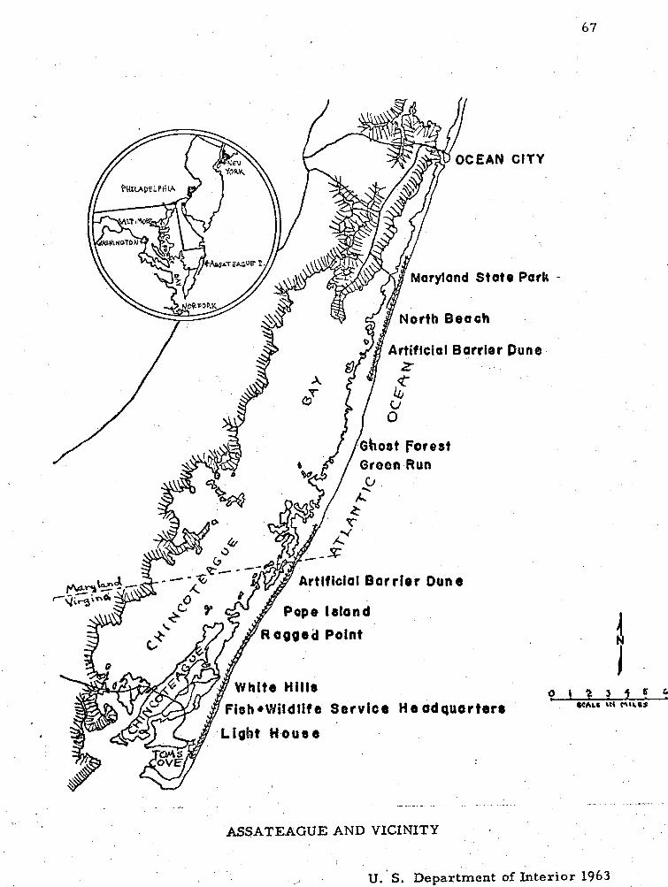
e Park -
ASSATEAGUE AND VICINITY
U. ' S, Department of Interior 1963
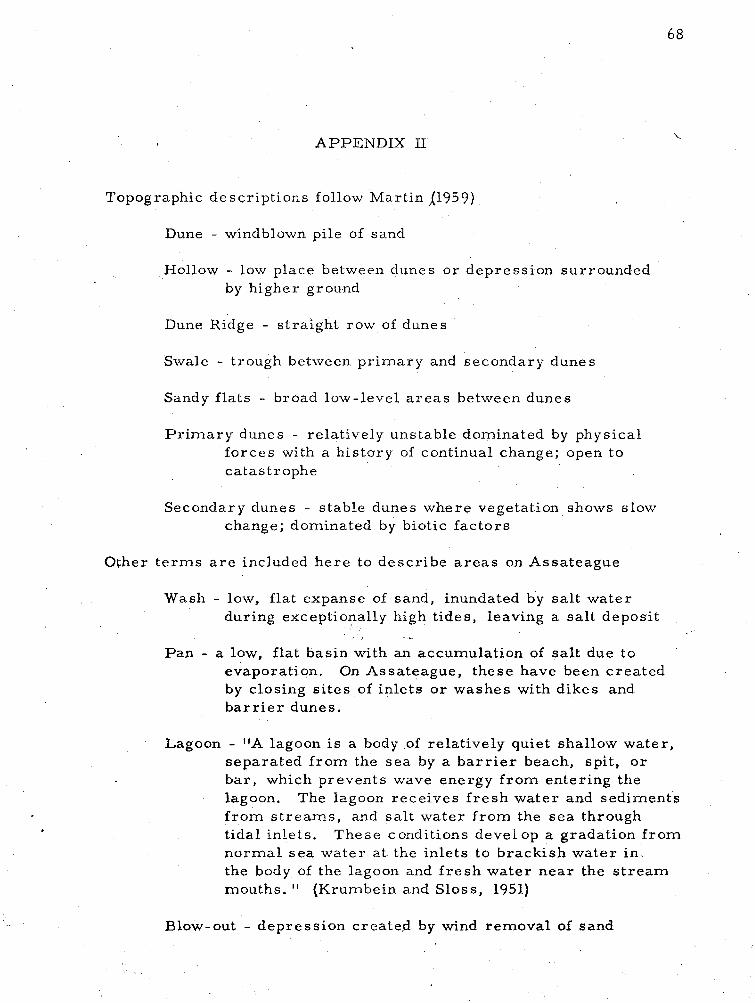
A P P E N D I X I1
Topographic descr ipt ions follow Mart in j1959)
Dune - windblown pile of sand
Hollow - low place between dunes o r depress ion surrounded by higher ground
Dune Ridge - st ra ight row of dunes
Swale - trough between p r imary and secondary dunes
Sandy f la t s - broad low-level a r e a s between dunes
P r i m a r y dunes - relatively unstable dominated by physical forces with a his tory of continual change; open to catastrophe
Secondary dunes - stable dunes where vegetation shows slow change; dominated by biotic fac tors
8 C
Other t e r m s a r e included he re to descr ibe a r e a s on Assateague
Wash - low, flat expanse of sand, inundated by sa l t water during exceptionally high t ides, leaving a sa l t deposit
Pan - a low, flat basin with an accumulation of sal t due to evaporation. On Assateague, these have been crea ted by closing s i t e s of inlets o r washes with dikes and b a r r i e r dunes.
Lagoon - "A lagoon i s a body of relatively quiet shallow water , separated f rom the s e a by a b a r r i e r beach, spit , o r bar , which prevents wave energy f r o m entering the lagoon. The lagoon rece ives f r e s h water and sediments f r o m s t r e a m s , and sa l t water f r o m the s e a through tidal inlets. These conditions devel op a gradation f rom norma l s e a water a t the inlets to brackish water i n . the body of the lagoon and f r e s h water n e a r the s t r e a m mouths. " (Krumbein and Sloss , 1951)
Blow-out - depress ion created by wind removal of sand
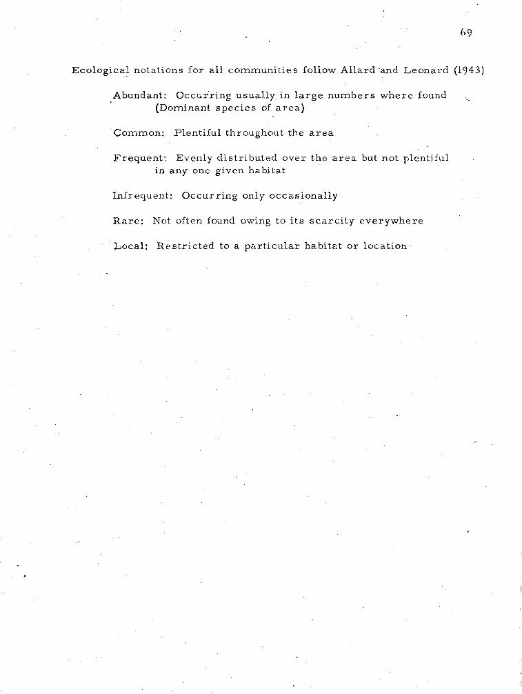
Ecological notations f o r a l l communit ies follow Allard-and Leonard (1943)
Abundant: Occur r ing usually i n l a rge number s where found (Dominant spec ies of a r e a )
Common: Plentiful throughout the a r e a
Frequent : Evenly dis t r ibuted over the a r e a but not plentiful . in any one given habitat
Infrequent: Occur r ing only occasionally
Ra re : Not often found owing to i t s s c a r c i t y everywhere
Local: Res t r ic ted to a par t i cu la r habitat o r location
APPENDIX I11
CATALOG O F THE VASCULAR P L A N T S O F ASSATEAGUE ISLAND, MARYLAND- VIRGINLA
The following is a l i s t of the vascular plants collected on Assateague Island during the growing seasons , 1964-67. Nomenclature following M. L. Fernald 's Gray ' s Manual of Botany, 8th Ed. 1950, except a s noted. F r e - quency notations follow Allard & Leonard (1943).
EQUISETACEAE (Horsetai l Fami ly)
1. Equisetum a rvense L. Common horse ta i l . North of Maryland State P a r k , one station.
LY COPODLACEAE (Club - m o s s Fami ly)
2. Lycopodium inundatum L. var . Bigelovii Tuckerm. Bog club m o s s . F r e s h m a r s h , t h r ee stations.
QSMUNDACEAE (Flowering f e r n Fami ly)
3. Osmunda cinnamomea L. Cinnamon fe rn . P ine woodland, r a r e .
4. 0. rega l i s L. Royal fern. F re sh ' m a r s h and pine woodlands, infrequent.
POLYPODIACEAE (Fe rn Fami ly)
5. Asplenium platyneuron (L. ) Oakes. Ebony Spleenwort. Two stations.
6. Dryopter i s Thelypter is (L. ) Gray. Shield fe rn . F r e s h m a r s h , frequent.
7. Onoclea sens ib i l i s L. Sensit ive fe rn . F r e s h m a r s h , Virginia, one specimen.
8. Pter id ium aquilinum (L. ) Kuhn var . pseudocaudatum (Clute) Heller. Bracken fern. Shrub and pine woodlands, infrequent,
7 1
9. Woodwardia areolata (L. ) Moore. Netted Chain fern. Pine woodlands, one specimen.
10. W. virginica (L. ) Sm. Virginian Chain fern. F r e s h m a r s h and pine woodlands, infrequent.
PINACEAE (Pine Family)
11. Juniperus virginiana L. Red cedar. Shrub, infrequent.
12. P inus echinata Mill. Yellow pine. Pine woodland, r a r e .
! f 13. P. Taeda L. Loblolly pine. Pine woodland, abundant.
14. P. virginiana Mill. J e r s e y or scrub pine. Pine woodland, infrequent.
15. P. rigida Mill. Pi tch pine. Pine woodland, r a r e . (Identification uncertain)
TYPHACEAE -(Cat -tail Family)
16. Typha angustifolia L. Narrow-leaved cat- tail. Impoundment, r a re .
17. T. latifolia L. Common cat-tail . F r e s h m a r s h , r a r e .
ZOSTERACEAE ('pondweed Family)
18. Potamogeton pectinatus L. Sago pondweed. Impoundment, infrequent.
19. P. pusillus L. Pondweed. Impoundment, infrequent.
20. Ruppia mar i t ime L. Ditch g ras s . F r e s h m a r s h , r a r e . " 1 GRAMINAE (Grass Fami ly) i R I 21. Agrost is alba L. Red top. Pine woodland, infrequent. i i 22. A. alba E. 1 var. palustr is (I-Iuds.) P e r s . Creeping bentgrass . W e t
a r e a s , woodlands, r a r e . I
23. A. hyernalis -(Walt. ) BSP. Ticklegrass . Mesic shrub, infrequent.
24. A. perennans {Walt. ) Tuckerm. ' Upland bent. ' F r e s h m a r s h , one station.
25. Aira praecox L. Hair g r a s s . r a r e .
26. Ammophila breviligulata F e r n g r a s s zone, abundant.
F r e s h m a r s h , pine woodlands,
. American beach g r a s s . Dune-
27. Andropogon scoparius Michx. var . l i t toralis (Nash) Hitchc. Beard g r a s s . Open secondary dunes, infrequent.
28. A. virginicus L. Broom-sedge. Open secondary dunes, infrequent.
29. A. virginicus L. var . abbreviatus (Hack. ) Fern . & Grisc . Bayside open secondary dunes, infrequent.
30. A. virginicus L. var . glaucopsis (Ell. ) Hitchc. Pine woodlands, infrequent.
31. Aris t ida tuberculosa Nutt. Sea- beach needle-grass . Open secondary dunes and pine woodland, infrequent.
32. Briza minor L. Quaking grass . F r e s h marsh , Virginia, one station.
33. Bromus commutatus Schrad. Brome g r a s s . Open secondary dunes, r a re .
34, Cenchrus tribuloides L. Sandbur. Dunegrass zone, frequent.
35. Cynodon Dactylon (L.) P e r s . Bermuda g ras s . Salt m a r s h and open secondary dunes, infrequent.
36. Digitaria fi l iformis (L. ) Koel. Slender c rabgrass . F r e s h m a r s h , r a r e .
37. D. sanguinalis (L.) Scop. Finger g r a s s . Dunegrass zone, infrequent.
38. Distichlis spicata (L. ) Greene Spike g r a s s . Salt m a r s h and pan, common.
39. Echinochloa pungens (Poir. ) Rydb. var. microstachya (Wieg. ) Fern . & Grisc. Weed in cultivated field, one specimen.
40. E. Walteri APursh) Nash. F r e s h m a r s h , infrequent.
41. Eleusine indica (L.) Gaertn. Goose g rass . Pinewoodland, r a r e .
42. Elymus virginicus L. Wild rye. Planted by Md. bridge.
43. Eragros t i s sp. Undetermined introduced species. In clay f i l l - roadsides, infrequent.
44. E. pectinacea (Michx.) Nees. Love grass . Shrub, r a r e .
45. E. spectabilis (Pursh) Steud. Tumble g rass . Salt m a r s h and open secondary dunes, infrequent.
46. Festuca arundinacea Schreb. Alta fescue. (from Hitchcock, not Fernald) Pan, one station.
47. F. arundinacea Schreb. Hort. var. K31. Planted along roadsides, Virginia.
48. F. ovina L. var. duriuscula XL. ) Koch Sheep' s-fescue. Mesic shrub, infrequent.
49. F. rubra L. Red fescue. Shrub and open secondary dunes, frequent.
>
50. Glyceria pallida (Torr . ) Trin. Manna-grass. F r e s h marsh , r a re . *I
51. G. septentrionalis Hitchc. Floating Manna-grass. F r e s h marsh , r a r e .
52. Holcus lanatus L. Velvet g rass . Roadsides, infrequent.
53. Leptochloa fil iformis (Lam.) Beauv. Feathergrass . Pan, frequent.
54. Lolium multiflorum Lam. Italian rye-grass . Roadsides and pan, infrequent.
A.
55. Muhlenbergia Schreberi J. F. Gmel.$ var. palustr is Scribn. Drop-seed. F r e s h marsh , r a re .
56. Panicum agrostoides Spreng. F r e s h marsh , r a re .
57. P. amarum Ell. Dunegrass and Marsh, frequent.
58. P. arnarulum Hitchc. & Chase. Beach grass . Dunegrass and marsh, frequent.
59. Panicum capillare L. Old witch grass . Salt m a r s h and pan, infrequent (with Salicornia).
60. 'P. columbianum Scribn. var. oricola (Hitchc. & Chase) Fern. Salt marsh , infrequent.
61. P. dichotomiflorum Michx. var. dichotomiflorum. Wet a r e a s in open secondary dunes , , infrequent.
62. P. lanuginosum Ell. var. fasciculatum (Torr . ) Fern. Mesic shrub, infrequent.
63. P. lanuginosum Ell. var. lanuginosum. Open secondary dunes, r a re .
var. Lindheimeri (Nash) Fern . Shrub, infrequent.
64. P. meridionale Ashe var , albemarlense (Ashe) Fern . Dunegrass zone and open secondary dunes, infrequent.
65. P. scoparium Lam. Mesic shrub and f resh marsh , frequent.
66. P. sphaerocarpon Ell. Open secondary dunes and shrub, infrequent.
67. P. virgatum L. Switch grass . Marsh and pan, frequent.
68. Paspalum floridanurn Michx. Pine woodland, one station.
69. P. 1 aeve Michx. Shrub, infrequent.
70. P. setaceurn Michx. Shrub, r a re .
71. Phragmites communis Trin. F r e s h marsh , infrequent.
72. Poa annua L. Annual blue-grass. Ruderal, r a r e .
73. Polypogon monspeliensis (L. ) Desf. Beardgrass. M a r s h and pan, common.
74. Pucinellia distans (L. ) Par l . Alkali-grass. Pine woodland, r a re .
75. P. fasciculata (Torr. ) Bickn. F r e s h marsh, r a re .
76. Setaria geniculata (Lam. ) Beauv. Bris t ly Foxtail. Salt marsh , frequent.
77. S. glauca (L. ) Beauv. Foxtail. Roadside, r a r e .
78. Spartina al ternif lora Loisel. F r e s h m a r s h , frequent.
79. S. patens (Ait. ) Muhl. Salt-meadow g ras s . M a r s h and pan, abundant.
80. Sphenopholis obtusata (Michx. ) Scribn. Mesic shrub, r a r e .
81. Triodia flava (L. ) Smyth Tal l Red-top. Tar g r a s s . Light house, one station'.
82. Tr ip las i s purpurea (Walt. ) Chapm. Sand-gras s. Dunegrass zone, infrequent.
83. Uniola laxa (L. ) BSP. Spike g ra s s . Woodlands, infrequent.
84. Vulpia Elliotea (Raf. ) Fern . Shrub, infrequent.
. 93. C. fi l iculmis Vahl. Marshes , pan, bayside dune, frequent.
85. V. octoflora (Walt. ) Rydb. var. tenella (Willd. ) Fern . Mes ic shrub, frequent.
i CYPERACEAE (Sedge Family)
86. Bulbostylis capi l lar is (L. ) C. B. Clarke. Open secondary dunes, frequent.
87. Carex Emmonsi i Dew. Sedge. Pine woodland, r a r e .
88. C. hormathodes Fe rn . F r e s h marsh , infrequent.
89. C. Longii Mac kenz. Pine woodland, infrequent.
90. Cladium mar isco ides (Muhl. ) Tor r . Twig-rush. F r e s h m a r s h , one station.
91. Cyperus esculentus L. Yellow nut-grass . F r e s h m a r s h , infrequent .
92. C, filicinus Vahl. Galingale. Marshes and pan, infrequent.
94. C, odor a tus L. Galingale. Marshes , infrequent.
95. C. r e t r o r s u s Chapm. Galingale. P ine woodlands, infrequent.
96. C. s t r igosus L. Galingale. open secondary dunes, frequent.
97. Eleocharis albida Tor r . Spike-rush: F r e s h m a r s h , one station.
98. E. palustr is (L.1 R, & S. F r e s h marsh , common.
99. E. parvula (R. & S , ) Link. F r e s h marsh , common.
100. E. rostellata T o r r . Marshes, common.
101. Fimbris tyl is autumnalis (L. ) R. & S. F r e s h marsh , infrequent.
102. F. castanea (Michx. ) Vahl. Marshes , frequent.
103. Fuirena pumila T o r r . (As F, squarrosa Michx. - National Herbarium) Umbrel la-grass . F r e s h marsh , r a r e .
104. Rhynchospora capitellata (Michx. ) Vahl. Beak-rush. Wet a r e a s in open secondary dunes, infrequent.
105. R . glomerata (L. ) Vahl Wet a r e a s in open secondary dunes, r a r e . (with Drosera)
106. Scirpus americanus P e r s . Three-square rush. ' Dunegrass zone and m a r s h e s , abundant.
107. S. cyperinus (L. ) Kunth Bulrush. F r e s h marsh , infrequent.
108. S . robustus P u r s h Impoundment edge, one station.
ARACEAE (Arum F a m i l d
109. Pel tandra virginica (L, ) Schott & Endl. Arrow Arum. Impoundment, Virginia, one station.
LEMNAGEAE (Duckweed Family)
110. Lernna minor L. Duckweed. Impoundment, one station.
111. Spisodela polyrhiza [L. ) Schleid. Water -flaxs eed. Impoundment, one station.
XYRIDACEAE (Yellow-e yed G r a s s Family)
112. Xyris caroliniana Walt. Yellow-eyed Grass . Fresh marsh , infrequent (with Drosera) .
113. X. Tor ta Sm. F r e s h marsh , infrequent.
COMMELINACEAE (Spiderwort Fami ly)
114. , Commelina communis L. Dayflower. . Light house, one station.
JUNCACEAE (Rush Family)
115. Juncus acuminatus Michx. Rush. F r e s h m a r s h and open secondary dunes, frequent.
116. J. biflorus Ell. Salt mar sh , frequent.
117. J. bufonius L. Toad-rush. Marshes , pans, and impoundment, frequent.
118. J. canadensis J. Gay Rush. F r e s h m a r s h , r a r e .
119. J. cor iaceus Mackenz. Mesic shrub, infrequent.
120. J. dichotomus Ell. F r e s h marsh , common.
121. J. dichotomus Ell . var . platy phyllus (Wieg. )-Fern. Salt mar sh , r a r e .
122. J. effusus L. B
var . solutus F e r n . and Wieg. Soft rush. F r e s h m a r s h , infrequent.
123. J. G e r a r d i Loisel . Black g r a s s . Salt m a r s h , r a r e .
124. J. marginatus Rostk. Rush. F r e s h marsh , r a r e .
125. J. margina tus Rostk. var. biflorus (Ell. ) Wood. F r e s h m a r s h and woodlands, infrequent.
126. J. Roemerianus Scheele Salt m a r s h , frequent.
127. J. scirpoides Lam. Rush. F r e s h m a r s h and open secondary dunes, common.
128. J. scirpoides Lam. var. compositus Harper . F r e s h m a r s h , r a r e .
129. J. tenuis Willd. Pa th rush. F r e s h m a r s h , r a r e .
130. J. Tor rey i Coville F r e s h m a r s h and open secondary dunes, frequent.
LILIACEAE - (Lily Family)
131. Allium vineale L. Field Garlic. Ruderal, r a r e .
132. Asparagus officinalis L. Garden asparagus. Ruderal, rare.
133. Smilax Bona-nox L. China- br ier . Woodlands, frequent.
134. S. glauca Walt. Sawbrier. Shrub and pine woodland, common.
135. S . rotundifolia L. Common greenbrier . Shrub and pine woodland, common.
136. S. Walteri P u r s h Red-berried greenbrier . Mesic shrub, frequent.
AMARYLLIDACEAE (Amaryllis Family)
137. Hypoxis hirsuta (L. ) Coville Stargrass . Open secondary dunes, one station.
I IRIDACEAE (Iris Family) I I
/ 138. Sisyrinchium atlanticum Bickn. Blue -eyed g r a s s , F r e s h i marsh , frequent. it .
ORCHIDACEAE (Or chid Family)
140. Habenaria cr i s ta ta (Michx. ) R . Br. Crested Yellow Orchid. Mixed woodland, r a re .
*
141. Spiranthes cernua {L. ) Richard Nodding Ladiesr - t resses . Marshes and pan, infrequent.
139. Cypripedium acaule Ait. Stemless (Pink) Lady's slipper. Pine woodland, local.
142. S. praecox (Walt.) S. Wats. Ladies1- t resses . Marshes and pan, infrequent:
143. S. vernalis Engelm. and Gray Marshes and pan, infrequent. i)
I SALICACEAE (Willow Family)
I I 144. Populus alba L. W h i t e Poplar. Shrub, r a r e .
I I I 145. P. canescens (Ait. ) Sm. Gray popular. Shrub, one station. t
146. Populus deltoides Marsh . Cottonwood. Light house, one station.
147. Salix babylonica L. Weeping willow. Planted b y cottage, one station.
148. S. n ig ra L. Black Willow. F r e s h m a r s h , shrub and woodlands, infrequent.
MYRICACEAE (Wax-myrtle Fami ly)
149. Myrica ce r i f e ra L. -Wax-myrtle. Shrub and woodlands, abundant.
150. M. pens ylvanica Loisel . Bayberry. Shrub and woodlands, common.
JUGLANDACEAE -(Walnut Family) - 151. Juglans nigra L. Black Walnut.. Planted by Light house, one
station.
FAGACEAE (Beech Family)
152. Quercus falcata Michx. Southern Red Oak. Shrub and woodlands, common.
153. Q. n i g r a L . W a t e r o a k . Woodlands, common.
154. Q. pa lus t r i s Muenchh. P i n Oak. Bayside open secondary dune, one station.
155. Q. Phel los L. Willow Oak. Shrub, r a r e .
156. Q. s te l la ta Wang. Pos t Oak. Mixed woodland, r a r e .
URTICACEAE (Nettle Family)
157. Boehmeria cylindrica (L. ) Sw. Bog-hemp. Light house, one station.
158. P a r i e t a r i a floridana Nutt. Pel l i tory. Light house, damp wooded slope, one station.
POLYGONACEAE (Buckwheat Family)
159. Polygonel laar t icu la ta (L . )Meisn . Jointweed. F r e s h m a r s h and open secondary dunes, frequent. (sand. on a l l dunes)
160. Polygonum amphibium L. var . stipulaceum (Coleman) Fe rn . Water Smartweed. F r e s h m a r s h , r a r e .
161. P . densiflorum Miesfi. Smartweed. Virginia, Bridge roadside, one specimen.
162. P. glaucum Nutt. Seabeach Knotweed. Dunegrass and pan, frequent.
(I l1 163. P. pensylvanicum L. Pinkweed. Salt marsh , infrequent.
164. P. punctatum Ell. Water Smartweed. F r e s h m a r s h , common.
165. Rumex Acetosella L. Sheep sor re l . Shrub and open secondary dunes, common.
166. R. Crispus L. Yellow Dock. Ruderal, r a r e .
I 167, R. Patientia L. Pat ience Dock. Ruderal, one station. I
I I
I I CHENOPODIACEAE (Goose foot Family)
f
168. Atriplex a rena r i a Nutt. Seabeach Orach. Marshes and pan,
1 abundant. I
I 169. A. patula L.
* 1 var . hhstata (L. ) Gray Orach. Marshes , abundant. I I
170. Bassia hirsuta (L. ) Aschers . Marshes and pan, frequent.
171. Chenopodium album L. Pigweed. Ruderal, r a r e .
I 172. C. ambrosioides L. Mexican Tea. Shrub, infrequent. I
173. Salicornia Bigelovii Torr . Dwarf Saltwort. Marshes and pan, , , frequent. ., ;'-3
174. S. e.uropaea L Chickenclaws. Marshes and pan, frequent.
fi 175. S. virginica L. Perennial Saltwort. Salt marsh , infrequent.
176. Salsola Kali. L. Saltwort. Dunegrass zone and m a r s h e s , local.
177. S. Kali L. var. caroliniana (Walt. ) Nutt. Common saltwort. Salt m a r s h and pan, local.
178. Suaeda l inearis (Ell. ) Moq. Sea-blite. Salt marsh , r a r e .
AMARANTHACEAE (Amaranth Family)
179. Amaranthus hybridus L. Pigweed. Ruderal, r a r e .
180. A. pumilus Raf. Seabeach Amaranth. Pan, frequent.
NYCTAGINACEAE (Four -0 ' Clock Family)
181. Mirabi l is Jalzpa L. Four O'clock. Dump nea r Wildlife office, one station.
PHYTOLACCACEAE (Pokeweed Family)
182. Phytolacca amer icana L. Pokeweed. Disturbed a r e a s , shrub and woodland, infrequent.
AIZOACEAE
183. Mollugo verticil lata L. Carpetweed. Dunegrass zone and open secondary dunes, infrequent.
, f I 184. Sesuvium mar i tmum (Walt. ) BSP. Sea-purslane. Dunegrass
zone and pan, frequent.
PORTULACACEAE (Purslane Family) 1
185. Portulaca oleracea L. Common Purslane. Light house, one station.
CARYOPHY LLACEAE (Pink Family)
186. Arenar ia peploides L. Seabeach Sandwort. Dunegrass, r a r e .
187. A. serpyllifolia L. Thyme-leaved Sandwort. Light house, one station.
188. Ceras t ium viscosum L. Mouse-ear Chickweed. Clay roadsides, infrequent.
189. C. vulgatum L. Common Mouse-ear Chickweed. Clay road- s ides , infrequent.
190. Lychnis alba Mill. White Cockle. Clay roadsides, infrequent.
191. Sagina decumbens (Ell. ) T. & G. Pearlwort . Mesic shrub, infrequent.
192. Scleranthus annuus L. Knawel. Clay roadsides , r a r e .
193. . Spergular ia mar ina (L. ) Griseb. Sand-spurrey. F r e s h m a r s h and pan, common.
194. S. rub ra (L.) J .&C. Presl Pan, Maryland, one station.
195. Stel lar ia media (L. ) Cyril10 Common Chickweed. Open secondary dunes, r a r e .
RANUNCULACEAE (Crowfoot Family]
196. Ranunculus Sardous Crantz Clay roadside, one specimen.
197. R. sce le ra tus L. Cursed Crowfoot. F r e s h m a r s h and impoundment.
LARD1 ZABALACEAE
198. Akebia quinata Dcne. Light house, one station. i
MAGNOLUCEAE (Magnolia Family) - 199. Magnolia virginiana L. Laure l -Magnolia, Sweet Bay.
Woodlands, infrequent.
U U R A C E A E (Laure l Fami ly)
200. P e r s e a Borbonia (L. ) Spreng. Red Bay. Pine woodland, infrequent.
201. Sassa f r a s albidum (Nutt. ) Nees. Sassaf ras . Shrub and wood- lands, infrequent.
CRUCIFERAE (Mustard Family)
202. Arabidopsis Thaliana (L. ) Heynh., Mouse-ear -cress . Clay roadside, r a r e .
203. Arabis glabra (L. ) Bernh. Tower-mustard. Clay roadside, , one specimen.
204. Barbarea verna (Mill. ) Aschers . Ea r ly Winter - c r e s s . Clay roadside, one specimen.
205. B. vulgaris R. Br. Common Wintercress . Clay roadside, one specimen.
206. B r a s s i c a Rapa L. B i rds ' Rape. Rudera l , one stat ion.
207. Cakile edentula (Bigel. ) Hook. (P ioneer on beach) duneg ra s s ' zone, pan and m a r s h e s , common.
208. Lepidium c a m p e s t r e (L. ) R. B r . Pine woodland, one spec imen
209. L. virginicum L. Peppe r G r a s s . Rudera'l, infrequent.
210. Raphanus Raphanis t rum L. Jointed Charlock. Rudera l , one stat ion.
DROSERACEAE (Sundew Fami ly )
211. D r o s e r a i n t e rmed ia Hayne Sundew. F r e s h m a r s h , infrequent .
HAMAMELIDACEAE (Witch-hazel Fami ly)
212. Liquidambar Styracif lua L. Sweet gum. Shrub and woodlands, infrequent.
PLATANACEAE -(Plane - t r e e Fami ly)
213. P la tanus occidentalis L. Sycamore . Mixed woodland, r a r e .
ROSACEAE (Rose Fami ly)
~ r n e l a n c h i e ; canadensis (L. ) Medic. Shad bush. X e r i c s h r u b and pine woodland, common.
Cra taegus c r u s -gall i L. Cock- spur Thorn. Light house, one stat ion.
Geum canadense Jacq. Light house, one station.
Potent i l la norvegica L. Roadside, r a r e .
P. r ec t a L. Cinquefoil. Glay roadside, r a r e .
P r u n u s m a r i t i m a Marsh . Beach P lum. Shrub, Maryland, one stat ion. (possibly introduced, s ince not known south of nor th Ocean Gi ty, Maryland.
P. P e r s i c a (L. ) Batsch Peach. Shrub, Maryland, one specimen.
P, sero t ina Ehrh. Black che r ry . Shrub and pine woodland, common.
222. Pyrus angustifolia Ait. var. spinosa (Rehd. ) Bailey Wild crab . Shrub, common.
223: P. arbutifolia (L. ) L. f . Red Chokeberry. Shrub, infrequent.
224. P. Malus L. Apple. Shrub, r a r e .
225. Rosa palustr is Marsh. Rose. Mesic shrub, infrequent.
226. R. rugosa Thunb. Rose. Back slope of b a r r i e r dune, Wildlife Refuge, planted i n 1966.
227. * Rubus argutus Link Bramble. Light house, one station.
228. R. cuneifolius P u r s h Sand Blackberry. Shrub and open secondary dunes,
229. R. f lagel lar is L. Northern Dewberry. Disturbed a i e d s , shrub and woodlands, infrequent.
230. R. pensilvanicus Poir . Shrub, r a r e .
I I
, t LEGUWNOSAE (Pulse Family)
231. Baptisia t inctoria (L. ) R. Br. Wild Indigo. F r e s h m a r s h , one station.
232. Cassia fasciculata Michx. Par t r idge Pea . Clay roadside, one station.
233. C. nicti tans L. Wild sensit ive plant. Wet a r e a s in open secondary dunes, infrequent.
234. Desmodium canescens (L. ) DC. Tick Trefoil . Shrub, r a r e .
235. D. rigidum (Ell. ) DC. Open secondary dunes, r a r e .
236. D. sessil ifolium (Tor r . ) T. &G. Open secondary dunes, r a r e .
237. Lespedeza h i r t a (L. ) Hornem. Bush Clover. Ruderal, r a r e .
I 238. Melilotus alba Desr. White sweet clover. Ruderal, one I station. i
1 I 239. M. officinalis (L, ) Lam. Yellow sweet clover. Clay roadside, I r a r e .
I * Treatment of Rubus f rom Gleason, and Cronquist (1965).
; 240. Robina Pseudo-Acacia L. Black locust. Light house, one station.
$1 241. . Strophostyle s helvola (L. ) Ell. Wild bean. Dunegras s zone
t and marshes, infrequent.
242. S. urnbellata (huhl. ) Britt. Wild bean. Dunegrass zone, infrequent.
243. Trifolium arvense L. Rabbit-foot clover. Clay fil l along 1 roadside, r a r e . I I 244. T . dubium Sibth. Clay fill along roadsides, r a r e .
I 245. T. pratense L. Red clover. Clay fill along roadsides, r a re .
I 246. T . procumbens L. Hop Clover. Clay fil l along roadsides,
rare. I I I
! 247. T. repens L. White clover. Glay f i l l along roadsides, r a r e .
I ' i 248. Vicia angustifolia Reichard. Clay roadside, one station.
1 249. Vicia Cracca L. Vetch. Clay roadside, one station.
LINACEAE (Flax Family)
250. Linum medium (Planch.) Britt. Flax. Marshes and pan, \
frequent.
I OXALIDACEAE (Wood- s o r r e l Family)
251. Oxalis europaea Jord. forma villicaullis Wieg. Ruderal, r a r e .
252. 0. europaea J s rd . var. Bushii (Small) Wieg. forma subglabrata Wieg. Light house, r a re .
i I 253. 0. s t r ic ta L. Ruderal, r a re .
I I GERANIACEAE (Geranium Family) I
254. Erodium cicutarium (L. ) L'Her . Stork's Bill. Wet clay road- side, local.
86
RUTACEAE (Rue Family)
255.. Xanthoxylum Clava-Herculis L. Hercules1-club o r Pr ick ley Ash. Light house, one station.
- POLYGALACEAE (Milkwort Family)
256. Polygala ver t ic i l la ta L. var . isocycla Fe rn . Milkwort. Salt m a r s h , infrequent.
EUPHORBIACEAE (Spurge Family)
257. Acalypha graci lens Gray Three - seeded Mercury . Pine woodlands, r a r e .
258. Euphorbia maculata L. Eye bane. Ruderal, two stations.
259. E . polygonifolia L. Seaside spurge. Dune g r a s s zone, frequent.
260. E . supina Raf. Milk purslane. Ruderal, r a r e .
CALLITRICHACEAE (Water - s ta rwor t Family)
261. Calli tr iche heterophylla P u r s h Water - starwort . Impoundment, one station.
ANACARDIACEAE (cashew Fami ly)
262. Rhus copallina L. Dwarf sumac. Shrub, and woodlands, frequent.
263. Rhus radicans L. Poison Ivy. Ubiquitous, except in sa l t m a r s h and pan.
AQUIFOLIACEAE (Holly Fami ly)
264. Ilex glabra (L. ) Gray Inkberry. Mes ic shrub, infrequent.
265. I. opaca Ait. American Holly. Shrub and pine woodland, infrequent.
AGERACEAE (Maple Family)
266. Acer rub rum L. Red Maple. Mes ic sh rub and woodlands, frequent.

RHAMNACEAE (Buckthorn Family)
267. Berchemia scandens (Hill) K. Koch Supple-Jack. Mixed wood- land, local, Virginia.
268. Rhamnus Frangula L. Alder Buckthorn. Mixed woodland, rar.e.
VITACEAE (Vine Fami ly)
269. Par thenocis sus quinquefolia (L. ) Planch. Virginia c reepe r . Dunegrass and shrub, frequent.
270. Vitis a e st ivalis Michx. Summer grape. P ine woodland, frequent.
C
271. V. rotundifolia Michx. Muscadine. Shrub and pine woodland, common.
MALVACEAE lMallow Family)
272. Althaea r o s e a Cav. Hollyhock. Escape, Light house, one station.
273. Hibiscus palustr is L. Swamp Rose-mallow. Pncludes H. Moscheutos L. and intermediate f o r m s ) Marshes , common.
274. Kosteletzkya virginica (L. ) P r e s l Seashore-mallow. Marshes , frequent. .
GUTTIFERAE (St. John 's -wort Family)
275. Ascyrum Hypericoides L. St. Andrews Cross . W e t a r e a s in pine .woodlands and open secondary dunes, frequent.
276. Hypericum boreale (Brit t . ) Bickn. St. John's wort. F r e s h m a r s h , frequent.
277. H. canadense L. F r e s h marsh , =re.
278. H. gentianoides (L. ) BSP. Orange Grass . Open secondary dunes, sh rub and pine woodland, frequent.
279. H. gymnanthum Engelm. & Gray St. John's-wort. F r e s h m a r s h , rare.
280. H. mutilum L. St. John's-wort. F r e s h m a r s h , r a r e .
281. H. virginicum L. F r e s h marsh; frequent. *
CISTACEAE (Rockrose Family)
282. Helianthemu~m canadense (L. ) Michx. Frostweed. Pine wood- land, frequent.
283. Hudsonia tomentosa Nutt. Beach-heath. Open secondary dunes, common.
284. Lechea Leggettii Brit t . & Holl. Pine woodlands, infrequent.
285. L. mar i t ima Leggett Pintveed. Open secondary dunes, infrequent.
VIOLACEAE (Violet Family)
286. Viola cucullata Ait. Open secondary dunes, Maryland, one specimen.
287. Viola lanceolata L. Lance -leaved Violet. F r e s h m a r s h , common.
CACTACEAE (Cactus Family)
288. Opuntia humifusa Raf. Pr ick ly P e a r . Open secondary dunes, infrequent. (with Andropogon)
LY THRACEAE (Loosestrife Family)
289. Ammannia t e r e s Raf. F r e s h m a r s h , Virginia, r a r e .
290. Lythrum l ineare L. Loosestr i fe . F r e s h m a r s h , infrequent.
291. Rotala ramosior (L. ) Koehne F r e s h m a r s h , Virginia, one station.
NYSSACEAE (Sour Gum Family)
292. Nyssa sylvatica Marsh Black gum. Shrub and woodlands, infrequent.
MELASTOMATACEAE (Melastoma Family)
293. Rhexia virginica L. Meadow beauty. Marshes andmpan, frequent.
ONAGRACEAE (Evening-primrose Family)
294. Ludwigia alternifolia L. Seedbox. Marshes, ' frequent.
295. Ludwigia palustr is (L. ) Ell. var . americana (DC. ) Fern . & Gri sc . Water-purslane. F r e s h marsh , common.
296. Oenothera biennis L. Evening Pr imrose . Dunegrass zone, Virginia, one station.
297. 0. frut icosa L. var . humifusa Allen Sundrops. F r e s h m a r s h , open secondary dunes and pine woodland, common.
298. 0. frut icosa L. var . l inearis (Michx. ) S. Wats Open secondary dunes, common.
299. 0. fruticosa L. var. unguiculata Fern . Disturbed a r e a s , infrequent.
300. 0. humifusa Nutt. Seabeach Evening P r i m r o s e . (Browsed selectively by Sika d e e r ) Dunegrass zone, common.
HA LORAGACEAE (Water -milfoil Family)
301. Myriophyllum pinnatum (Walt. ) BSP. Water -milfoil. Impound - I
ments , r a r e . I
302. Proserpinaca palustr is L. Mermaid-weed. F r e s h m a r s h 1
and impoundments, common. ,
ARALLACEAE (Ginseng Family) . .
303. Aralia spinosa L. Herculed- Club. Shrub, infrequent.
UMBELLIFERAE (Pars ley Family)
304. Centella e rec ta (L. f. ) Fern . F r e s h marsh , common.
305. Daucus Carota L. Wild ca r ro t . Ruderal, r a r e .
306. Hydrocotyle umbellata L. Water -penny:wort. F r e s h m a r s h , common.
307. H. verticil lata Thunb. Water-penny-wort. F r e s h m a r s h , common.
308. Ptil imnium capillaceum (Michx. ) Raf. Mock Bishopt s Weed. F r e s h marsh , common.
309. Sanicula canadensis L. Black Snakeroot. Light house, one station.
CORNACEAE (Dogwood Fami ly)
310. Cornus florida L . Flowering Dogwood. ~ i x e d woodland, one specimen.
PYROLACEAE (Wintergreen Family)
311. Chimaphila maculata (L. ) P u r s h P ips i ssewa. P ine woodland, r a r e .
312. Monotropa Hypopithys L. Pinesap. Pine woodland, Maryland, one station.
313. M. uniflora L . Indian-pipe. Pine woodland, Virginia, one station. ERICACEAE (Heath Fami ly)
314. Gaylussacia baccata (Wang. ) K. Koch Huckleberry. Shrub and pine woodland, frequent.
315. Vaccinium a t r o c o c c u m ~ G r a y ) Hel ler (Vacciniums include undetermined hybrids) Shrub, common.
316. V. caesa r i ense Mackenzie. Mesic shrub, r a r e .
317. V. corymbosum L. Pncludes V. mar i anum Wats. and V. aus t r a l e Smal l which a r e separa ted by Camp, but not included in Fernald. ) Shrub and pine woodland, common.
318. V. macrocarpon Ait. Cranber ry . F r e s h m a r s h , Virginia, one station. (with D r o s e r a j
PRIMULACEAE ( P r i m r o s e Fami ly)
319. Anagallis a r v e n s i s L. Sca r l e t Pimpernel . Ruderal , r a r e .
320. Samolus parvif lorus Raf. Water -P imperne l . F r e s h m a r s h , frequent. (with Pt i l imnium)
PLUMBAGINACEAE (Leadwort Fami ly)
321. Limonium carol inianum .(Walt. ) Bri t t . Sea-Lavender. Salt m a r s h e s , frequent.
EBENACEAE (Ebony Family)
LOGANLACEAE (Logania Family)
I I 1
324. Polypremum procurnbens L. F r e s h m a r s h , r a r e .
322. Diospyros virginiana L. Pe r s immon . Shrub and pine woodland, infrequent.
OLEACEAE (Olive Family)
323. Ligustrum vulgar e L. Pr ivet . Ruderal, planted two stations.
GENTIANCEAE (Gentian Family)
325. Bartonia virginica (L. ) BSP. F r e s h m a r s h , Virginia, one station.
326. Sa batia s t e l l a r i s P u r s h Sea Pink. Marshes , common. (Highly var iable species)
327. S. Stel lar is P u r s h fo rma albiflora Bri t t . Marshes , infrequent.
APOCYNACEAE (Dogbane Family)
328. Apocynum cannabintlm. L. Indian hemp. Shrub and pine woodland, infrequent.
ASCLEPLADACEAE (Milkweed Family)
329. Asclepias incarnata L. var . pulchra (Ehrh. ) P e r s . Swamp milkweed. F r e s h m a r s h , infrequent.
330. A. lanceolata Walt. Milkweed. Mixed woodland, infrequent.
331. A. tuberosa L. Butterflyweed. Pine woodland, Virginia, one station.
CONVOLVULACEAE (Convolvulus Family)
332. Convolvulus sepium L. Hedge Bindweed. F r e s h m a r s h , infrequent.
POLEMONIACEAE (Polemonium Family)
333. Phlox Drummondii Hook. Clay roadside, one 'specimen.
VERBENACEAE (Vervain F;.mily)
334. Lippia lanceolata Michx. Fog-fruit. F r e s h marsh , Virginia, frequent.
335. Verbena officinalis L. European Vervain. Light house, one station.
LABLATAE (Mint Family)
336. Lamium amplexicaule L. Henbit. Light house, one station.
337. Lycopus americanus Muhl. Water-horehound. Marshes, frequent.
338. Monarda punctata L. var . villicaulis Pennell Hor semint. Open secondary dunes, r a re .
339. Nepeta catar ia L. Catnip. Light house, one station.
340. Prunella vulgaris L. Heal-all. Clay roadside, one station.
341. Teucrium canadense L. American G rmander. Edges of mesic thickets and bay side marshes , frequent.
342. Trichostema dichotomum L. Blue curls . Roadside by Wildlife Office, local.
SOLANACEAE (Nightshade Family)
343. Datura Stramonium L. , Jimson weed. Open stabi l ized dunes, infrequent.
344. Solanum carolinense L. Ruderal, two stations.
345. S. nigrum L. var. vulgare L. Black nightshade. Open secondary dunes, infrequent. (Gleason, 1952)
1 SCROPHULARUCEAE (Figwort Family)
i 1 346. Bacopa Monnieri (L.) Pennell . Water-hyssop. Marshes and
A' pan, frequent.
347. Gerardia mar i t ima Raf. Gerardia. Pan, r a r e .
348. Gerardia purpurea L. Salt m a r s h and pan, frequent.
349. Linaria canadensis (L. ) Dumont Old-field toadflax. Shrub and open secondary dunes, frequent.
350. Ver bascum Blattaria L. Moth-mullein. Shrub, r a r e .
351. V. Thapsus L. Common mullein. Ruderal, r a r e .
352. Veronica arvens is L. Corn speedwell. Ruderal, r a r e .
353. V. peregrina L. Neckweed. Ruderal, r a r e .
BIGNONIACEAE (Bignonia Family)
354. Campsis radicans (L. ) Seem. Trumpet-creeper . Shrub and pine woodland, infrequent.
OROBANCHACEAE (Broom- rape Family)
355. Orobanche minor Sm. Pine woodland, r a r e .
PLANTAGINACEAE (P lan tain Family)
356. Plantago ar i s ta ta Michx. Bracted plantain. Open secondary dunes, Virginia, one station.
357. P. lanceolata L. Buckhorn. Ruderal, r a r e .
358. P. Rugelii Dcne. Broad-leaved plantain. Pine woodland, r a r e .
359. P. virginica L. Hoary plantain. Ruderal, r a r e .
RUBIACEAE (Madder Family)
360. Dioda t e r e s Walt. Buttonweed. F r e s h m a r s h , r a r e .
361. D. virginiana L. Buttonweed. F r e s h m a r s h , frequent.
362. Galium hispidulum Michx. Bedstraw. F r e s h m a r s h , one specimen.
363. G. obtusum Bigel. F r e s h m a r s h , frequent.
364. G. paris iense L. F r e s h marsh , one station. .
365. G. pilosum Ait. Mixed woodland, infrequent'.
366. Houstonia nigricans (Lam. ) Fern . Open secondary dunes, r a r e .
367.. H. purpurea L. F r e s h m a r s h , Virginia, one specimen.
368. Mitchella repens L. Par t r idge-ber ry . Pine woodland, r a r e .
CAPRIFOLIACEAE (Honeysuckle Family)
369. Lonicera japonica Thunb. Japanese Honeysuckle. Shrub and pine woodland, common.
370. L. sempervi rens L. Trumpet honeysuckle. Shrub and pine woodland, infrequent.
371. Sambucus canadensis L. Common Elder . Shrub and open secondary dunes, infrequent.
372. Viburnum recognitum Fern . Arrow-wood. Mesic shrub, r a re .
CAMPANULACEAE (Bluebell Family)
373. Lobelia Cardinalis L . Cardinal-flower. Impoundment, Virginia, one station.
374. Specularia perfoliata (L. ) A. DC. Venus's looking-glass. Clay roadsides, local;
COMPOSITAE (Composite Family)
375. Achillea Millefolium L. Common Yarrow. Pine woodland, r a r e .
376. Ambrosia ar temisi i fol ia L. Common ragweed. Ruder'al, r a r e .
377. Anthemis a rvens is L. Corn-chamomile. Clay roadsides, local.
378. Aster dumosus L. var . coridifolius (Michx. ) T. and G. Light house, one station.
379. A. ericoides L. Heath a s t e r . Salt m a r s h , Maryland, one station. i
380. A. pilosus Willd. var. demotus Blake. Salt marsh, infrequent.
381. Aster simplex Willd. var . ramosiss imus (T. Sr G. ) Cronq. Shrub, Virginia, one station.
382. A. spectabilis Ait. Pine woodland, one station.
383. A. subulatus Michx. Salt m a r s h , frequent.
384. A. subulatus Michx. var . euroauster Fe rn . & Grisc. Marshes and pan, frequent.
385. A. tenuifolius L. Aster . Salt m a r s h and pan, frequent.
386. Baccharis halimifolia L. Sea-myrtle. Mesic shrub and open secondary dunes, frequent.
387. Bidens bipinnata L. Spanish needles. Open secondary dunes, frequent.
388. B. frondosa L. Bur-marigold. F r e s h m a r s h , frequent.
389. B. laevis (L. ) ESP. Marshes, infrequent.
390. Borrichia frutescens (L. ) DC. Sea ox-eye. Salt marsh , Virginia, two stations.
391. Chondrilla juncea L. Skeleton-weed. Open secondary dunes, r a r e .
392. Chrysanthemum Leucanthemum L. Light house, one station.
393. Chrysopsis nervosa (Willd. ) F e r n Silkgrass. Pine woodland, two stations.
394. Cichorium Intybus L. Chicory. Pan, Virginia, one station.
395. Circium horridulum Michx. Yellow thistle. Mesic shrub and pine woodland, frequent.
396. C. vulgare (Savi) Tenore Bull Thistle. Pine woodland, r a r e .
397. Eclipta alba (L. ) Hassk. Yerba-de-Tago. F r e s h marsh , infrequent.
398. Elephantopus nudatus Gray Elephant's foot. Woodlands, infrequent .
399. E. tornentosus L. evil's-gra&dmother. woodlands, infrequent.
400. Erecht i tes hieracifolia (L. ) Raf. Fireweed. F r e s h m a r s h and mes ic shrub, infrequent.
401. ' Erigeron canadensis L. Horseweed. Two dis turbed, wet a r e a s , r a r e .
402. E. pusillus Nutt. Fleabane. Dunegrass zone and shrub, frequent.
403. E. s t r igosus Muhl. va r . s t r igosus Daisy Flea bane. Ruderal, r a r e .
404. Eupatorium album L. Thoroughwort. Pine woodland, r a r e .
405. E. capillifolium (Lam. ) Small Dog -fennel. Open secondary dunes and roadside, common.
406. E . hyssopifolium L. var . hys s opifolium. Open secondary dunes, infrequent.
407. E. hyssopifolium L. var . laciniatum Gray Pine woodlands, frequent.
408. E. leucolepis (DC. ) T. & G. Pine woodlands, r a r e .
409. E. pilosum Walt. Mesic shyub, infrequent.
410. E. pubescens Muhl. F r e s h m a r s h and m e s i c shrub, frequent.
411. E. rotundifolium L. Shrub and open secondary dunes, frequent.
412. E. rugosum Houtt. Ruderal, r a r e .
413. E. serot inum Michx. F r e s h m a r s h , infrequent.
414. Gaillardia pulchella Foug. Gaillardia. Ruderal, Virginia, one station.
415. * Gnaphalium purpureum L. var. falcatum (Lam. ) T. & G. Purple cudweed. Shrub and pine woodland, frequent.
416. G. purpureum L. var. purpureum Purple cudweed. Shrub and pine woodland, frequent.
* Treatment of Gnaphalium var ie t ies f r o m Gleason and Cronquist (1965).
417. Gnaphaliu~n obtusifolium L. Catfoot. F r e s h m a r s h , frequent.
418. Helianthus petiolaris Nutt. Light house, one station.
419. Heterotheca subaxillaris (Lam. ) Britt. & Rusby Camphor weed. F r e s h m a r s h and open secondary dunes, infrequent.
420. Hieracium Gronovii L. Hawkweed. Pine woodland, infrequent.
421. Hypochaeris radicata L. Cat1s e a r . Dunegrass zone, Virginia, one station.
422. Iva frutescens L. Marsh Elder. (Highwater shrub) Marshes and mes ic shrub, common.
423. Krigia virginica (L. ) Willd. Dwarf dandelion. Open secondary dunes, frequent.
424. Lactuca canadensis L. var . longifolia (Michx. ) Farw. Wild lettuce. Open secondary dunes, Maryland, one specimen.
425. L . canadensis L. I
var . latifolia Ktze. Open secondary dunes, r a r e . I
426. L. Scariola L. Prickly Lettuce. Roadside, one station.
427. Mikania scandens (L. ) Willd. Climbing hempweed. Mesic shrub, frequent.
428. Pluchea foetida (L. ) DC. Stinking fleabane. F r e s h marsh , pan and mesic shrub, frequent.
429. P. purpurascens (Sw. ) DC. Marsh fleabane. Marshes , frequent.
430. Pyrrhopappus carolinianus (Walt. ) DC. Fa l se Dandelion. Roadsides, r a re .
431. Senecio tomentosus Michx. Groundsel. Open secondary dunes, r a re .
432. Solidago fi stulosa Mill. Goldenrod. Open secondary dunes, infrequent.
433. S. graminifolia (L. ) Salisb. Open secondary dunes, rare.
434. S. rugosa Ait. var. aspera (Ait. ) Fern. F r e s h marsh , rare.
435. S. sempervi rens L. Seaside Goldenrod. Dunegrass zone, shrub and m a r s h , common.
436. S. sempervi rens L. var . mexicana (L. ) Fern . Dunegrass zone, infrequent.
437. S. tenuifolia Pursh . Dunegrass zone and mes ic shrub, frequent.
438. Sonchus a spe r (L.) Hill. Spiny-leavedsow-thistle. F r e s h marsh , r a r e .
439. S. oleraceus L. Common Sow- thistle. Open secondary dunes, r a r e .
440. Taraxacum officinale Weber. Common Dandelion. Ruderal, infrequent.
441. Xanthium St rumar ium L. Cocklebur. Dunegras s zone, infrequent .
A P P E N D I X TABLE 1
Number of t ransects , and distance (in dec imeters ) occupied by,given species along 47 twenty-meter line t ransects in the dunegrass community.
Species Number Distance
Ammophila breviligulata 47 296
Rhus radicans 2 100
Solidago sempervirens 11 25
Cakile edentula
Myrica ce r i f e ra
Euphorbia polygonif olia 8
, Oenothera humifusa 5 6
Diospyros virginiana
Panicum amarum
Cenchrus triuloides
Spart ina patens
Er igeron pusillus
Smilax glauca
Linaria canadensis
Salsola Kali
Hudsonia tomentosa
Panicum m e ridionale var . a lbemarlense
APPENDIX TABLE 2
N u m b e r of t ransects , and distance (in decimeters) occupied by'given species along 59 line t ransects in the transition zone.
Species
Myrica cer i fera
Number
3 7
Distance
1426
Rhus radicans 34 1183
Ammophila b r eviligulata 5 9
Myrica pensylvanica 2 7
Solidago sempe rvirens 3 6
Parthenoci s sus quinquefolia 10
Vitis rotundifolia
Rubus cuneifolia
1 1 I
Bacchari s halimifolia 12 103 I
I Andropogon virginicus 4 103
1 ' I 1 Quercus falcata 1 1
Vulpia octoflora
Rhus copallina
Spartina patens
Pinus Taeda
Festuca r u b r a 5
P y r u s angustifolia var . spinosa 1
Panicum amarum 8
Rumex Acetosella
I
APPENDIX TABLE 2 con't. 1 r, /j / j Species Number Distance
Er igeron pusillus 11
Solidago tenuifolia 6 1 6
Vaccinium atrococcum 1
Ilex opaca
Eupatorium rotundifolia
Salix ni g r a
Oenothera humifusa 4 9
Panicum vi r gatum 3 9
Lonicera japonica 3 6
1
Scirpus amer icanus i 4 5
Echinochloa Walteri 1 5
Prunus serot ina 3 4
Oenothera f ruticosa 9 2
Linaria canadensis 6 2
Rosa palustr is i
Diospyros virginiana I
Smilax rotundif olia 1 2
Smilax glauca 5 1
Euphorbia polygonif olia 4 1
Helianthemum canadense ! 3 i -
Panicum scoparium 2
I I Iva frutescens 1 ' 1
APPENDIX TABLE L con1t.
Spec ies
S a s s a f r a s albiduin
Cenchrus t r ibu lo ides
Juncus dichotomus
\
Number
1
1 Ar i s t ada tubercu losa 2 I
Juncus acunl inatus 2
Pan i cum mer id iona le
I < T e u c r i u m calladense 2 I
I '
C a r e x Longii 1
I
I P h r a g m i t e s communis 1
f
Senecio toinentosus 1
Smi lax Wal te r i i
Dis tance
1
L 1
d l
c1
el
~1
'51
'4 1
1 1
e 1
4 1
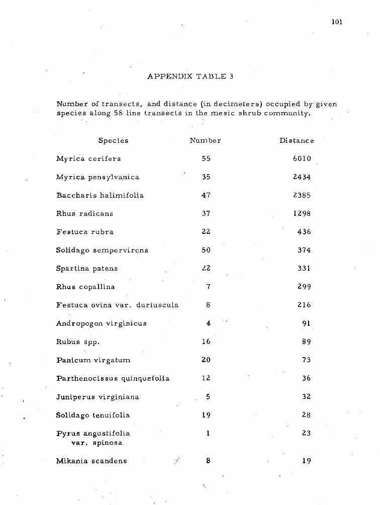
APPENDIX TABLE 3
Number of t r ansec t s , and dis tance (in dec ime te r s ) occupied by 'given species along 58 line t r ansec t s in the m e s i c sh rub community.
Species Number Distance
Myr ica ce r i f e r a 55 6010
Myr ica pensylvanica ' 35 2434
Bacchar i s halimifolia 47 2385
Rhus radicans 37 1298 1
Fe s tuca r u b r a 22 436
Solidago semperv i r ens 50 374
Spart ina patens I
Rhus copallina
Fes tuca ovina va r . dur iuscula 8
Andropogon virginicus 4 '
I E ! Rubus spp.
I
i I Panicum vi rga tum
I i Par thenocissus quinquefolia 12 3 6 k E
Juniperus virginiana 5 3 2
Solidago tenuifolia
P y r u s angustifolia var. spinosa
Mikania scandens ,i- 8
L
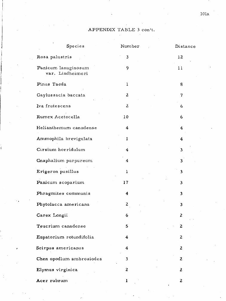
APPENDIX TABLE 3 con't .
Species Number
Rosa pa lus t r i s 3
Panicum lanuginosum v a r . Lindheimeri
P inus Taeda 1
Gaylussacia baccata
Iva f ru tescens
Rumex Acetocella
Helianthemum canadense
Ammophila br evigulata
C i r s ium hor r idulum
Gnaphalium pur pur eum
Er ige ron pusil lus
Panicum scopar ium
Phragmi te s communi s
1 Phytolacca a m e r icana 2
I Carex Longii 6
Teucr ium canadense
Eupator ium rotundifolia
Sc i rpus amer i canus
Chen opodium ambros iodes 1
3
1 Elymus virginica 2
A c e r rubrum
Distance
12
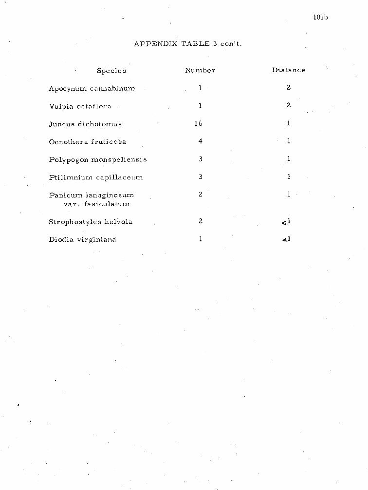
A P P E N D I X TABLE 3 con't.
Species Number
Apocynum cannabinurn 1
Distance
2
Vulpia octaflora 1 2
Juncus dichotomus 1 6 1
Oenothera frut icosa 4 1
Polypogon monspeliensis
Ptilimniuln capillaceum
Panicum lanugino sum va r . fasiculatum
Strophostyles helvola
Diodia virginiana
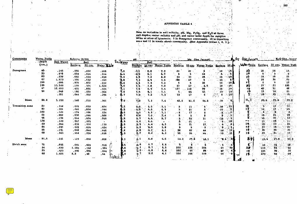
.... . - --.
. . . . . . . I i ::. ~. . . . . . . . .
. . . . ~ . .
. . . . . - . . . . . . . . . . . . . . . . .
. . 1.. . . I
. , . . . . . _ L . : . . ,
I I I ~ommunity ~ a t a r ~;blc
. . . -I<&& Soil Water .(cm. )
buaegra*q $5 - .I45 .056 -032
I 53 .078 .054 .044 89 ,270 -062 -024
I 47 I. 570 .306 .53L
150 .086 .076 .a22 190 13.300 41 18.690 .45b .896 90 .248 ,106 .a20
-351 .044 ' .Old
! Mean . 88.8 3.190 . I 4 0 .215 0 . . . 7 7.3 / , Iran*itiql=ofie 8D -144 .OZ8 .020 80 . 181 .a46 .024
-100 . I24 .174 -106 65 .088 -038 -046 95 . I f 0 .a64 .024
135 . I 2 0 .062 .OZb . . 60 .054 -038 .030 . 85 .095 .028 .026
55 -191 .048 .044 60 -343 .664 ,036
Maan . 81.4 .I51 .119 -038 . .
Shrub *one . 75 .098 .046 . -028 34 -430 1.184 . 142 25 ,420 . .498 .096
I 60 1.496 8.6 .48
. . . . . . . .
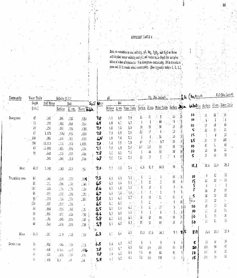
* I I
APPENDIX TABLE 4 /
' , I
Data on variation in soil salinity, pIi, Mg, Pi051 and K20 at three f , h J soil depths; water salinity and pH; and water table depih for sal . 5 taken a t sites of transects: 9 indunegrass community, 10 in transition
I zone and 11 in mesic shnb conmunity, JSee Appendix tables 1, 2, I ,] ,
nples
Community Vate: Tajle Depth (cm* I h w a b l e Surface 20 cm. 'lu'ater Table _------
Mean I I ,P 3,190 ,140 , 2 1 5 ,361 1.3 7 . 4 4E16 41 0 6 i 1 8 10 91 20,b 2 J t o 2 9 a D
I
Transition zone 80 ,144 .C18 ,120 ,0214 3% 6.5 6,9 ?+1 5 11 5 10 15 3 12
80 111 ,046 ,024 ,044 \ & 6 4 5 6-6 6.9 5 21 1 ! C 15 i 2 12 . Zi C i A
101 ,124 ,174 . ! o h ,124 Po,& 6,1 6,8 1 .1 5 17
65 ,088 ,038 ,040 ,0$1 I&? b a a T S 4 5
i 95 ,170 , ~ b 4 , 9 2 4 ,05,0 $3 5 , 6,6 5 4 1 5 55
Shrub lone i 5 ,093 04$ O L U J I B 63 6.g 6.7 6 t 8 5 i .UO i 9 i ? ( ,,:: J E ~ ~ x.0 i,i 5 . 7 '0' '5' lie 166 2 2
1' ,420 . 4 9 d 04, ,u4; 78 9 , 6 , 4 152 19 11 I t 1,456 6, P ;I; ,6a ~ , q , 5 . 2 4 " 2 lib 110
\
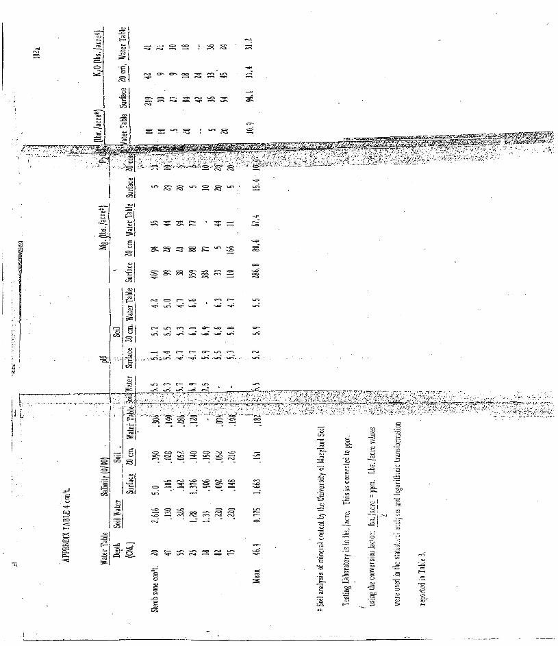
103
LITERATURE CITED
Adams, D.A. 1963. F a c t o r s influencing vascu l a r plant zonation i n North Caro l ina s a l t m a r s h e s . Ecology 44:445-455.
I Agnew, A. D. Q. 1961. The ecology of Juncus effusus L. i n North Wales.
Jour. Ecol. 49:83-102.
Al lard , H. A. and E. C. Leonard. 1943. The vegetation and f l o r i s t i c s of Bull Run Mountain, Virginia. Gas tanea 8:l- 64.
Anderson, R, R . , R. G. Brown and R. D. Rappleye. 1968. Water quali ty and plant d is t r ibut ion along the upper Patuxent River , Maryland. Chesapeake Sci. 9:145-150.
Bernard , J. M. 1963. Lowland f o r e s t s of Cape May format ion in southern New J e r s e y . Bull. N. J. Acad. Sci . 8:l-12.
Bourdeau, P. F. and D. A , Adams. 1956. F a c t o r s i n vegeta t ional zonation of s a l t m a r s h e s n e a r Southport , North Carol ina . Ecol. Soc. Am. Bull. 37:68
Boyce, S . G. 1954. The s a l t s p r a y community. Ecol . Monog. 24:29-67. i
Brown, C.A. 1959. Vegetation of the Outer Banks of North Carol ina . Louis iana Sta te Univers i ty P r e s s . Baton Rouge. 179pp.
Burk, J. C. 1961. A f l o r i s t i c study of the Outer Banks of North Carol ina . Unpublished PhD khesis. Univers i ty of North Carolina, Chapel Hill. 123pp.
Canby, W.M. 1864. ~ o t e s of botanical v i s i t s t o the lower p a r t of Delaware and the e a s t e r n sho re of Maryland. P r o c . Acad. Nat. Sci . (Philadelphia). 16-19.
Chadwick, H. W. and P. D. Dalke. 1965. P lan t success ion on dune sands in F r e m o n t County, Idaho. Ecology 46:765 -779.
Chapman, V. J. 1960. Sa l t m a r s h e s and s a l t d e s e r t s of the world. Leonard Hill Books Ltd. London. 392pp.
i ' 4 , I rl . 1964. Coas ta l vegetation. The MacMillan Co. New York. il 245pp.
I
Chickering, J. W. 1878. A season ' s botanizing. F ie ld and F o r e s t 3:154-155.
I
Chrys l e r , M.A. 1910. Ecological plant geography of Maryland; coas ta l zone; wes t e rn sho re d i s t r i c t . Md. Weather S e r v . , Spec. Publ. 3:149-193.
. 1930. The or igin and development of the vegetation of Sandy Hook. Bull. T o r r e y Club 57:163-176.
Clovis, J. F. 1968. The vegetation of Smith Island, Virginia. Castenea 33:115-120.
Cope, J. A. 1926. Loblolly pine, a woodland crop. U. of Md. Ext. Se r . Bull. 41. College P a r k 49pp.
Cowles, H. C. 1899. The ecological re la t ions of the vegetation on the sand dunes of Lake Michigan. Bot. Gaz. 27:95-117, 167-175.
Daubs, E . H. 1965. A monograph of Lemnaceae. Ill. Biol. Monog. 24. Univers i ty of I l l inois P r e s s . Urbana. 118pp.
Ducatel , J. T . 1837. Outlines of the physical geography of Maryland embrac ing i t s prominent geological f ea tu re s . T rans . Md. Acad. Sci. & Lit. I:24-28.
Eg le r , F. E. 1942. Check l i s t of the f e r n s and flowering plants of the Seashore State P a r k , Cape Henry, Virginia. Mimeo. Publ. New York State College of F o r e s t r y . Syracuse . 75pp. \
F a s s e t t , N. C. 1957. A manual of aquatic plants. The Univers i ty of Wisconsin P r e s s . Madison. 382pp.
Fender , F. A. 1938. The f lora of Seven Mile Beach, New Je r sey . Bartonia 19:L3-41.
Ferna ld , M. L. 1935. Midsummer vascu la r plants of sou theas te rn Virginia Rhodora 37:378-413, 423-454.
. 1936. P lan ts f r o m the outer coas ta l plain of Virginia. Rhodora 38:376-404, 414-452.
. 1950. Gray ' s manual of botany. 8th edition. Amer ican Book Co. New York 1632pp.
Ganong,' W. F. 1903. The vegetation of the Bay of Fundy sa l t and diked m a r s h e s . Bot. ~ a z . 36:161-186, 280-302, 349-367, 429-455.
Gleason, H. A. 1952. The new Brit ton and Brown i l lus t ra ted f l o r a of nor th- e a s t e r n United S ta tes and adjacent Canada. New York Botanical Gardens New York. 1726pp.
-1 and Ar thur ~ r o n ~ u i s t . 1965. Manual of vascula r plants of
nor theas te rn United States and adjacent Canada. D. V a n Nostrand Co. Pr inceton. 810pp.
Harpe r , R.M. 1907. A midsummer journey through the coas ta l plain of the Carol inas and Virginia. Bull. To r rey Bot. Club 34:351-377.
. 1909. C a r window notes on the vegetation of the Delaware Peninsula and southern Virginia. To r reya 9:217 -226.
. 1919. A fo re s t reconnaissance of the Delaware Peninsula. Jour . F o r e s t r y 17:546-555.
Har shbe rge r , J. W. 1901. An ecological study of the New J e r s e y s t rand f lo ra . P roc . Acad. Nat. Sci. Philadelphia 52:623-671.
. 1903. Additional observations on the s t rand f lo ra of New Jersey . P r o c . Acad. Nat. Sci. Philadelphia 54:642-669.
. 1909. The vegetation of the salt m a r s h e s and of the sa l t and f r e s h water ponds of nor thern coas ta l New Je r sey . P roc . Acad. Nat. Sci. Philadelphia 61:373-400.
Harvil l , A. M. J r . 1965. The vegetation of P a r r a m o r e Island, Virginia. Castanea 30:226-228.
. 1967. The vegetation of Assateague Island, Virginia. Castanea 32:105-108.
Hinde, H. P. 1951. The ver t ica l distr ibution of sa l t marsh phanerogams in re la t ion to tide levels. Ecol. Monog. 24:209-225.
Hitchcock, A. S. 1950. Manual of the g r a s s e s of the United States . U. S. Dept. Agri . Misc. Pub l . 200. Washington, D. C. 1050pp.
Hotchkiss, Neil. 1967. Underwater and floating-leaved plants of the United S ta tes and Canada. U.S. Dept. Int. Res. Publ. 44. Washington, D. C. 125pp.
Johnson, D. S. and H. W . York. 1915. The re la t ion of plants to tide levels . .Carnegie Inst. Wash. Publ. 206. Washington, D . C . 162pp.
Johnson, E.S. 1900. Notes on the f lora of the banks and sounds a t Beaufort, North Carolina. Bot. Gaz. 30:405-410.
Kearney, T. H. 1900. The plant covering of 0cracol;e Island. U.S. Nat. Herb. Contri. 5:261-319.
Kershaw, K. A. 1964. Quantative and dynamic ecology. Edward Arnold Pub. Ltd. London 183pp.
Knieskern, P. D. 1857. A catalogue of plants growing without cultivation in the counties of Monlnouth and Ocean, New J e r s e y .
Krumbein, W. C. and L. L. S loss . 1951. S t ra tegraphy and sedimentation. W. H. F r e e m a n and Go. San F ranc i s co .
Kurz , Herman, and Kenneth Wagner. 1957. Tidal m a r s h e s of the Gulf and Atlantic coas t s of l lorthe r n F lo r ida and Char les ton, South Carolina. F lo r ida Sta te Univers i ty Studies 24. Ta l lahassee . 168pp.
Laing, C. C. 1958. Studies i n the ecology of Ammophila brevi l igula ta F e r n . ; seedling su rv iva l and i t s re la t ion to population i n c r e a s e and d i spe r sa l . Bot. Gaz. 119:208-216.
Lamsom-Sc r ibne r , F. 1898. Sand-binding g r a s s e s . U. S. Dept. Agri . Yearbook Washington, D. C. 405-420.
Latrobe, B. J. 1799. Memoi r on sandhi l ls of Cape Henry, Virginia. T rans . Am. Phil. Soc. 4:439-443.
L e m s , Kornelius. 1963. P l an t s observed on As sa teague Island, Virginia. Unpublished mimeo. Gaugher College. Baltirnore. 1 p.
Lewis , I. F. 1917. The vegetation of Shackleford Bank. N. C. Geol. Econ. Surv. 46:l-40.
M a r m e r , H. A. 1948. I s the Atlantic coas t sinking? The evidence f r o m the tide. Geog. Rev. 38:652-657.
Mart in , E. V. and F . E . Clement s . 1939. Adaptation and or ig in in the plant world. I. F a c t o r s and functions in coas ta l dunes . Carn . I r s t . of Wash. Publ. Washington, D. C. 107pp.
Mar t in , W. E. 1959. The vegetation of Island Beach Sta te P a r k , New J e r s e y . Ecol. Monog. 29:l-46.
McAtee, W. L. 1918. Notes on the plants of Wallops Is land, [Accolnac Co. ) Virginia. T o r r e y a 18:70-71.
Mi l le r , J. R . , R . H . Seher , and N. K . Usherwood. 1963. Methods used fo r tes t ing soi l s amp le s a t the Univers i ty of Maryland Soil Test ing Laboratory. U. of Md. Agron. Mimeo. No. 37 College P a r k 16pp.
Mi l le r , W. R. and R . E. Egle r . 1950, Vegetation of the Wequetequock- Pawcatuck t idal m a r s h e s , Connecticut. Ecol . Monog. 20:133-172.
Mooney, H. A. 1963. Physiological ecology of coas tala subalpine and alpine populations of Polygonum bistortoides Pu r sh . Ecology 44:812-816.
Nicholson, W. R. and R . D. VanDeusen. 1954. M a r s h e s of Maryland. Resou rce Study Repor t No. 6. M-d. Dept. Res . and Educ. Solomons, Maryland
Nobuhara, Haj ime. 1967. Analysis of coas ta l vegetation on sandy sho re by biological types i n Japan. Jap. Jour . Bot. 19: 325 -351.
Norton. J. B. S . and R. G. Brown. 1946. A catalog of the vascu l a r plants of Maryland. U. of Md. Agri . Exp. Sta. College Pa rk . 50pp.
Oosting, H. J. 1948. The study of plant communit ies . W.H. F r e e m a n and Co. San F ranc i sco . 389 pp.
. 1954. Ecological p r o c e s s e s and vegetation of the m a r i t i m e s t rand in the sou theas te rn United States . Bot. Rev. 20:226-262.
. and W. D. Billings. 1942. F a c t o r s effecting vegetation zonation on coas t a l dunes. Ecology 23:131-142.
and P. E. Bourdeau. 1959. The ~ n a r i t i m e l ive oak f o r e s t in North Carolina. Ecology 40:148 -152.
P r i t c h a r d , D. W. 1952. The physical s t ruc ture , c i rculat ion and mixing i n a coas ta l plain es tuary . The Johns Hopkins Univers i ty Tech. Rep. 111. The Chesapealce Bay Inst . Ref. 52-2.
Pe rk ins , S. 0. and S. R . Bacon. 1928. Soil survey of Worces te r County, Maryland. U . S. Dept. A g r i . , Bu r . Chem. and Soi ls No. 11. S e r . 1924. 31pp.
Ranwell, E .S . , E. C. F. Bird, J. C. E. Hubbard, ancl R . E. Stebbings. 1964. Spar t ina sa l t m a r s h e s i n southern England. Jour . Ecol. 52:627. 641.
Redmond, P. J. 1932. A f l o r a of Worces te r County, Maryland. Contri. Biol. Lab. Catholic' Universi ty of Amer i ca 11. 99pp.
Reed, J , F. 1947. The re la t ion of the S p a r t i n e t u n g labrae n e a r Beaufort, North Carolina, to ce r ta in edaphic fac tors . Am. Mid. Nat. 38:605-614.
Kusby, H. H. 1891. A botanical excurs ion to Assa teague Bay. Bull. T o r r e y Bot. Club 18:250-255.
Sieling, F. W. 1960. The r e s o u r c e s of Worces te r County coas ta l wate rs . Md. Dept. R e s . and Educ. Ref. No. 60-10. Solonlons, Maryland 17pp.
108
Small , J. A. and W. E. Mart in . 1958. A part ia l iy annotated catalogue of vascu la r pIants repor ted f rom Island Beach State P a r k , New Je r sey . Bull. T o r r e y Bot. Club 85:368-377.
Smal l , J , K; 1929. Peninsula Delmarva. Jour . N. Y . Bot. Garden 30:62-71.
Smith, A. V. 1940. Some plants recent ly iound in the coas ta l plain of Maryland. Rhodora 423276-231.
Snow, L. M. 1902. The ecology of the Delaware coast . Bot. Gaz. 34:284-306.
. 1913. P r o g r e s s i v e and r e t rog re s s ive changes in the plant associat ion of the Delaware coast . Bot. Gaz. 55:45-55.
Steel , R . G. D. and J. H. T o r r i e . 1960. Pr inc ip les and p rocedure s of s ta t i s t i cs . McGraw-Hill Book Go. New York 481pp.
Agr i . Yearbook. Washington, D. C. 321-326.
Stone, Witmer , 1910. The plants of southern New Je r sey . Rep. N. J. State Museum.
Swei tzer . E. M. 1968. An anatomical and ecological study of Sal icornia Bigelovii T o r r . Unpublished Mas t e r ' s Thes i s . Universi ty of Mary - land, College Pa rk . 30pp.
Tatnall , R. R. 1946. Flora of Delaware and the e a s t e r n shore . Soc. Nat. Hist. of Delaware. Lancas t e r , Pennsylvania 310pp.
Taylor , N. 1939. Salt to le rance of Long Island sal t m a r s h plants. N. Y. Sta te Museum Circ . 23. Albany.
T ides t rom, Ivar . 1913. Notes on the f lo ra of Maryland and Virginia I. Rhodora 15:lOl-106.
Trui t t , R . V. 1968. High winds. . . h i g h t ides. Nat. Res . Ins t . , Univ. of Md. Educ. Ser . 77. College Pa rk . 35pp.
U. S. Dept. In te r io r . 1963. Assateague Island and v i cinity. Study of r ec rea t i on values and potential use. U. S. Dept. Int. , Bur. Outdoor Recreat ion. Washington, D. C. 32pp.
Vogl, R . G. 1966. Sal t m a r s h vegetation of upper Newport Bay,. California. Ecology 4 7 : 8 0 - 8 7.
Vokes, I-I. E. 1961. Geography and geology of Maryland. Md. Geol. Surv. Bull. 19 243pp.
Wagner, R . H. 1964. The ecology of Uniola paniculata L. i n the dune s t r and habi tat of North Carolina. Ecol. Monog. 34:79-96.
f
Wells, B. W. 1928. Plant cornlnunities of the coas ta l plain of North Carol ina and the i r success iona l relat ionship. Ecology 9:230-242.
. 1938. Sal t sp ray ; a n irriportant fac tor in coas t a l ecology. Bull. T o r r e y Bot. Club 65:485 -520.
- . and I. V. Shunk. 1931. The vegetation and habi ' tat f ac to r s of the c o a r s e r sands of the North Carolina coas t a l plain; a n ecological s t u d y . Ecol. Monog. 1:465-520.
Williamson. C.S. 1909. Notes on the f lo ra of cen t r a l and southern Delaware. -
T o r r e y a


![Print - Sun Earth · 2343 2343 2343 2343 2343 2343 2343 2343 3565 3565 3565 3565 3565 3565 3565 3565 [mm] 40-300 15-300 40-300 [mm] 2675 3445 4420 7070 2675 3445 4420 7070 2675 3445](https://img.pdfslide.us/doc/110x75/5e7c55371ac19940f3606150/print-sun-earth-2343-2343-2343-2343-2343-2343-2343-2343-3565-3565-3565-3565-3565.jpg)