Embed Size (px)
Citation preview

Maine’s Best Practices for Development of
Multi-Modal Corridor Management Plans
December 2007
Developed by Androscoggin Valley Council of Governments, in partnership with:
Maine Department of Transportation
Federal Highway Administration
Eastern Maine Development Corporation
Greater Portland Council of Governments
Hancock County Planning Commission
Kennebec Valley Council of Governments
Lincoln County Planning Office
Midcoast Council for Business Development
Midcoast Regional Planning Commission
Northern Maine Development Commission
Southern Maine Regional Planning Commission
Washington County Council of Governments

Maine’s Best Practices for Development of
Multi-Modal Corridor Management Plans
Page 2 of 21
Background and Context
This Multi-Modal Corridor Management Plan (MMCMP) guide was developed to provide a
technical resource for state and Regional Council staff who are undertaking development of
transportation corridor management plans. Maine’s eleven Regional Councils have been
instrumental in helping the Maine Department of Transportation (MaineDOT) develop
Connecting Maine, the state’s long-range transportation plan. This document identifies
statewide and regional issues and opportunities through the year 2030, establishes goals and
performance-based strategies to reach those goals, and identifies the funding shortfalls that must
be addressed to keep Maine competitive and to meet the socio-economic and environmental
needs of those who live, work and play in Maine.
The Regional Councils utilized significant public involvement in developing their regional needs
and objectives. During this process, they identified thirty-eight Corridors of Regional Economic
Significance for Transportation (CRESTs). Through the public participation process, a series of
transportation, land use and economic objectives was developed for each CREST. From those
objectives, the Regional Councils developed a series of strategic investments. We are now
prepared to undertake the next step – defining a prioritized list of transportation and other
strategies that will meet the regional objectives of each Corridor of Regional Economic
Significance. This next step is being termed Multi-Modal Corridor Management Planning.
MMCMPs are intended to be undertaken for each of Maine’s thirty-eight Corridors of Regional
Economic Significance in a prioritized manner, as identified by the Regional Councils through
their public participation process. MMCMPs will be developed by an Advisory Committee
consisting of the representatives from MaineDOT, the Regional Council, affected municipalities
and others who are interested in transportation, land use and economic development, as well as
related quality of life considerations. The MMCMPs will contain detailed, prioritized action
plans with achievable implementation schedules.
Examples of the action items that will be developed through the MMCMP process might include
generating new and/or updating municipal zoning and other ordinances to preserve the capacity
of the public transportation system components (aviation, bicycle/pedestrian, marine, port, rail,
road and bridge, transit), developing context sensitive solutions to address “quality of place”
concerns regarding transportation facilities and other approaches to ensure that:
• Maine’s transportation assets will be protected from the effects of over-development,
which places unnecessary demands for capacity improvements on Maine roads and other
public transportation infrastructure;
• Maine’s communities will identify their priority needs on a regional basis, ensuring that
when funding does become available, it will be placed to the best use of the community
and the region;
• Maine’s communities will identify their multimodal transportation needs, including
strategic modal connections; and
• MaineDOT will have clear direction regarding the needs and desires of the communities
served by upcoming major transportation capital improvements.

Maine’s Best Practices for Development of
Multi-Modal Corridor Management Plans
Page 3 of 21
1. Introduction This Multi Modal Corridor Planning Guide has been developed to assist with the preparation of
regional multimodal transportation corridor plans in the State of Maine. The idea for this guide
grew out of the recognition that many of Maine’s transportation needs can be most effectively
addressed at the corridor level rather than on a piecemeal basis. Limited resources for
transportation improvements at all levels of government are dictating more creative and
collaborative approaches to solving and preventing transportation problems. A corridor
approach offers the opportunity for communities to collectively plot a future strategy which
makes the best possible use of available resources, takes advantage of synergies to produce the
best outcomes, and has a greater chance of becoming a reality than would otherwise be the case
if each community acted on its own.
This guide establishes a framework for the corridor planning process and is intended to provide
broad guidance but not be so prescriptive that it requires a plan to include data that may not be
relevant to a particular situation. Flexibility in the planning process will be critical to ensuring
that corridor plans are relevant to the communities, as well as to the state, and are useful for
coordinating local land use decisions with regional transportation improvements and
investments.
Transportation Land Use Cycle
IMPROVED ACCESS
LAND
USES
CHANGE
INCREASED
TRIP
GENERATION
INCREASED CONFLICT
INCREASED
CONGESTION
ROAD
IMPROVEMENTS
ARE MADE
LAND
VALUES
INCREASE
LAND
USE
ACTIVITY
OCCURSLESS
DESIRABLE
LIVING
Source: MaineDOT
This planning process is intended to be used by Maine’s Regional Councils as they develop
corridor plans for Corridors of Regional Economic Significance for Transportation (CREST)
identified by the Regional Councils for Connecting Maine, the MaineDOT’s 2007 Long Range
Plan. Corridor planning is a comprehensive transportation planning process that integrates the
social, economic, historic, scenic, cultural, land uses, and natural resource values of the
communities in a corridor.
Maine’s Best Practices for Development of
Multi-Modal Corridor Management Plans
Page 4 of 21
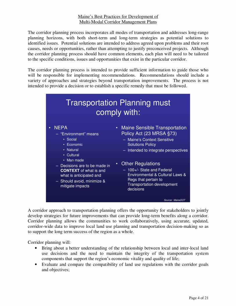
The corridor planning process incorporates all modes of transportation and addresses long-range
planning horizons, with both short-term and long-term strategies as potential solutions to
identified issues. Potential solutions are intended to address agreed upon problems and their root
causes, needs or opportunities, rather than attempting to justify preconceived projects. Although
the corridor planning process should have common elements, each plan will need to be tailored
to the specific conditions, issues and opportunities that exist in the particular corridor.
The corridor planning process is intended to provide sufficient information to guide those who
will be responsible for implementing recommendations. Recommendations should include a
variety of approaches and strategies beyond transportation improvements. The process is not
intended to provide a decision or to establish a specific remedy that must be followed.
Transportation Planning must comply with:
• NEPA
– “Environment” means
• Social
• Economic
• Natural
• Cultural
• Man made
– Decisions are to be made in
CONTEXT of what is and
what is anticipated and
– Should avoid, minimize &
mitigate impacts
• Maine Sensible Transportation Policy Act (23 MRSA §73)
– Maine’s Context Sensitive
Solutions Policy
– Intended to integrate perspectives
• Other Regulations
– 100+/- State and Federal
Environmental & Cultural Laws &
Regs that pertain to
Transportation development decisions
Source: MaineDOT
A corridor approach to transportation planning offers the opportunity for stakeholders to jointly
develop strategies for future improvements that can provide long-term benefits along a corridor.
Corridor planning allows the communities to work collaboratively, using accurate, updated,
corridor-wide data to improve local land use planning and transportation decision-making so as
to support the long term success of the region as a whole.
Corridor planning will:
• Bring about a better understanding of the relationship between local and inter-local land
use decisions and the need to maintain the integrity of the transportation system
components that support the region’s economic vitality and quality of life;
• Evaluate and compare the compatibility of land use regulations with the corridor goals
and objectives;

Maine’s Best Practices for Development of
Multi-Modal Corridor Management Plans
Page 5 of 21
• Identify and assess opportunities for successful development or expansion of all forms of
transportation;
• Provide a framework for identifying, prioritizing and funding improvements within the
corridor;
• Balance economic growth, land use, local values and quality of life with transportation
services and needs;
• Give communities and MaineDOT a long-term strategy for coordinating growth and
transportation decisions, so that those decisions work with, and not against, each other;
and
• Develop a plan to maintain or improve the mobility, safety, economic vitality, sense of
community, etc. of a corridor.
Insert Statewide Regional Corridors Map
(fit on this page)
Maine’s Best Practices for Development of
Multi-Modal Corridor Management Plans
Page 6 of 21
2. Approach to Developing a Multi-Modal Corridor Management Plan While the issues and objectives may vary from one corridor to the next, the approach will be the
same regardless of the corridor location. The following paragraphs provide a brief overview of
how Multi-Modal Corridor Management Plans (MMCMP) will be developed. The processes
listed below provide an overview and further described in subsequent Chapters.
2.1. Identify Corridor Initially, the Regional Council, with assistance from MaineDOT, will identify the broad area to
be included within the MMCMP. For instance, it may include the entire Corridor of Regional
Economic Significance (CREST) if the CREST is not very large. However, it may be deemed
appropriate to select a smaller segment to coincide with Service Centers and their associated
communities, labor market areas, or other circumstances unique to the corridor. In some
instances, more than one Regional Council may be included in the corridor as well.
2.2. Develop Public Participation Plan The Regional Council will develop a public participation plan specific to the corridor to be
studied. The Regional Council will review the public participation plan it uses in all of its
activities and determine if it will sufficiently address the needs of the MMCMP. The public
participation plan will also be reviewed by the Advisory Committee upon its formation, as
described below.
2.3. Establish Advisory Committee The Regional Council will invite all municipalities served by the corridor, MaineDOT, Maine
State Planning Office, Maine Turnpike Authority, Metropolitan Planning Organization(s) if
applicable, local Chambers of Commerce, large employers within the region, major
transportation providers (public passenger and freight, all modes), scenic byway and other
tourism interests, environmental groups and others that might have an interest in transportation
and its impacts to land use and economic well-being. This group will then establish an Advisory
Committee to participate in development of the MMCMP and to report back to their constituents
on its progress and to seek input as it is developed.
The Advisory Committee will refine the corridor description and will develop a Purpose and
Needs statement for the corridor.
2.4. Develop Multi-Modal Corridor Management Plan The Advisory Committee, with technical assistance from the Regional Council, MaineDOT and
other participating agencies, will collect and analyze data, forecast future conditions and develop
alternative scenarios for consideration in developing the goals and strategic action plans for the
corridor. The action plans will be prioritized, with a lead group identified for each action, an
estimated cost and an implementation schedule.
Maine’s Best Practices for Development of
Multi-Modal Corridor Management Plans
Page 7 of 21
The completed MMCMP will result in the development of a Memorandum of Agreement, which
all parties will sign to ensure broad support. This document will enable MaineDOT and other
funding agencies to be assured that broad support exists for all of the items identified in the
action plan. This is a critical element that is necessary for implementing any major capital
investments.
The MMCMP will then be monitored on a regular basis and biennial progress reports will be
issued to all signatories of the Memorandum of Agreement.
3. MaineDOT and Regional Councils Involvement In order to minimize confusion and to establish clear understanding by all parties involved, the
following roles and responsibilities should be reviewed, discussed, modified as deemed
appropriate and agreed upon at the onset of the effort. MaineDOT Roles and Responsibilities include:
• Provide overall guidance and assistance as deemed necessary:
o Attend meetings and participate in all other aspects of MMCMP development;
o Assist the Regional Council in conducting technical analyses; and
o Assist in visioning and all other aspects of MMCMP development.
• Provide available technical data to the Regional Council. The Regional Council and
MaineDOT will decide on a case-by-case basis if supplemental data is needed. Data may
include but is not limited to:
o Multi-modal transportation system components information, such as federal
functional classification of roads, the number and width of travel lanes and shoulders,
posted speed limits, location and number of spaces at park and ride lots, transit, rail
and other modal transportation asset information, access management requirements,
etc.;
o Multi-modal transportation system components conditions, such as pavement
condition rating, sufficiency rating, bridge rating, etc.;
o Operations data, such as average annual daily traffic, truck types and volumes,
seasonal traffic variations, turning movement counts, crash history, average speed,
number of transit users, etc.;
o Future projections, including estimated traffic counts, congestion, etc.;
o Future planned projects within the area; and
• Review and comment on the draft MMCMP.
Regional Council Roles and Responsibilities include:
• Define in broad terms the initial MMCMP boundaries;
• Identify stakeholders;
• Develop a public participation plan;
• Establish schedule and budget and advise MaineDOT of any changes;
• Review all appropriate MaineDOT and other planning documents, and provide
summaries of findings to the Advisory Committee;
• Schedule and conduct all Advisory Committee meetings and other activities;

Maine’s Best Practices for Development of
Multi-Modal Corridor Management Plans
Page 8 of 21
• Ensure appropriate MaineDOT and other planning partners are kept informed and
provided opportunity to participate at all levels;
• Generate the draft MMCMP, and edit as appropriate to generate the final product(s);
• Ensure MMCMP implementation will be monitored; and
• Provide status update reports at an appropriate frequency.
The role of the Regional Councils and MaineDOT together include:
• Review and summarize findings, conclusions and recommendations;
• Prioritize previous and existing planning efforts and recommendations related to the
corridor;
• Develop and respond to new recommendations based on identified and agreed upon
problems as well as committee findings of any gaps in previous or existing planning
efforts;
• Incorporate short, medium and long-term time-line land use and transportation strategies
into an Action Plan with the intent of resolving identified corridor issues. Be sure to
identify implementation responsibility;
• Develop and respond to strategies that improve the integration of transportation planning
and decision-making with economic and land use planning and development in the
corridor;
• Develop/respond to strategies that improve regional cooperation and communication
among corridor towns, the regions, the state and other stakeholders;
• Identify leaders and develop strategies to recruit local leadership to monitor, advocate
and/or perform action strategies developed in the Action Plan; and
• Identify additional needs and opportunities, if appropriate, for the corridor.
4. Public Participation A Public Participation Plan should be developed and monitored to ensure that a Corridor
Management Plan, as well as Sensible Transportation Policy Act (STPA) requirements are
adhered to, and also to document public process in the event National Environmental Policy Act
(NEPA) becomes applicable in the future.
4.1. Purpose The public should be consulted throughout the planning process. This can be accomplished by a
number of methods including holding a series of public meetings or by speakers’ bureau
presentations, mailings and other written processes and/or via an interactive web-site. The
number of meetings or methods of outreach can vary but should be decided upon by the
Advisory Committee early in the process. Some likely outreach points include, at kick-off to
introduce the planning process and to solicit initial information, after the data collection phase is
complete to inform the public of what the data show as problems and opportunities, when
preliminary strategies and recommendations are being considered, and for presenting the
completed plan. All outreach measures must be open to interested individuals and the public.
All meetings must be held in compliance with the Americans with Disabilities Act.
Public participation ensures that the issues and needs of residents, businesses, travelers and
others in the corridor are adequately addressed through the study process and recommendations.
Maine’s Best Practices for Development of
Multi-Modal Corridor Management Plans
Page 9 of 21
Public participation should be an on-going part of the planning process and can occur through
any number of means, including:
• Public meetings;
• Municipal board, Advocacy Group (MMA, Friends groups, Maine Motor Transport,
Land Trusts, etc.), Chamber of Commerce, or service club presentations;
• Newsletters and brochures;
• Information kiosks in public places that provide information and ways to return feedback
or questions
• Media releases;
• Website;
• Surveys; and
• Other approaches.
The purposes of public participation, no matter the method, are to obtain information from the
public regarding:
• Issues, needs and opportunities along the corridor;
• Perceptions of issues and goals;
• Attitudes and values;
• History of past efforts undertaken to identify, address or correct problems (both
successful and unsuccessful);
• Ideas for ways to address needs or problems;
• Feedback on potential strategies; and
• To garner support for implementation strategies.
4.2. Identify Stakeholders Critical to the success of the planning process is the identification and inclusion of stakeholders
who are likely to be affected by the outcomes of the planning effort. Individual stakeholders
bring a unique focus to issues; their involvement will have a direct bearing on the ways in which
the corridor is experienced. Identification of key stakeholders will be critical to the success of
implementation efforts. Stakeholders should be identified by the Regional Council early in the
planning process along with a sense of their level of commitment to participate. Stakeholder
groups should be identified on the basis of driving forces and identified needs affecting the
corridor. Stakeholder involvement should address some combination of the following groups:
• Municipal officials;
• County officials, including public safety;
• Regional transportation planners;
• Largest employers within the corridor;
• Major freight haulers, trucking companies with the corridor;
• Commuters and others dependent on the corridor;
• Transit provider(s), public, private, social service etc.;
• Railroad officials, if applicable;
• Bicycle/pedestrian advocates;
• Chambers of Commerce and business groups;
• Natural resource professionals;

Maine’s Best Practices for Development of
Multi-Modal Corridor Management Plans
Page 10 of 21
• Public health officials;
• Scenic Byway and other corridor groups;
• Other community groups;
• Maine Department of Transportation;
• Maine State Planning Office;
• Maine Turnpike Authority, if applicable; and
• Other interest groups, as appropriate.
The Regional Council should invite stakeholders to a kickoff meeting, at which time they will be
invited to participate and to possibly serve on the Advisory Committee.
4.3. Establish Advisory Committee The Advisory Committee is responsible for establishing a vision and goals for the corridor
planning process and for overseeing development of the plan. The Advisory Committee does not
need to have representation from all of the stakeholder groups but it should be comprised of
stakeholders who have or will have a principal responsibility in implementing the plan. It should
be a goal that each member represent a separate constituency to ensure balanced and broad
representation. An information-sharing and decision-making process should be established so
that all parties understand their roles and responsibilities at the beginning of the process. The
Advisory Committee should seek input from all stakeholders and may do so in a variety of ways.
For each corridor planning effort, all “players” need to be at the table at the beginning of the
process, including a representative from the MaineDOT. MaineDOT staff can play a pivotal role
in educating local officials, business owners, and the public about funding limitations, the need
to make wise investments in an era of declining resources, and the importance of preserving
capacity through wise land use choices.
4.4. Define Advisory Committee Procedures and Goals
One of the first tasks to be determined by the Advisory Committee will be to establish
procedures for working together. It may be necessary to determine whether conflicts in visions,
concerns, issues, etc. are present among committee members and address those before they can
proceed as a group. Taking the time to identify and agree upon roles and responsibilities of
committee members can assure that the work of the committee can move forward.
The procedures for the Advisory Committee should include:
• How often, when and where to meet;
• Whether or not there will be a chair person or other meeting moderator;
• The manner in which members are recognized to speak;
• The manner in which attendees who are not on the Advisory Committee are recognized to
speak;
• Minute taking, circulation and approval process; and
• How implementation strategies are to be made.
Maine’s Best Practices for Development of
Multi-Modal Corridor Management Plans
Page 11 of 21
Procedures should be put in writing so that all Advisory Committee members are familiar with
the process. These procedures should be provided to new members that may participate in the
future.
The roles of the Advisory Committee should include:
• Identify goals, objectives and strategies for the corridor
• Guiding the planning process;
• Serving as liaison to their respective constituent groups;
• Guiding the development of a long-term coalition of stakeholders to maintain an on-
going public process to identify and address corridor issues, and to measure progress on
the corridor; and
• Encouraging a broad range of stakeholder participation in all planning efforts.
5. Development of a Multi-Modal Corridor Management Plan All Multi-Modal Corridor Management Plans should provide the information described in the
following sections.
5.1. Contents of a Multi-Modal Corridor Management Plan In order to provide consistency across the state, all MMCMPs should be similar in appearance
and approach, though the content will vary widely, depending on specific corridor factors. All
MMCMPs final documents should therefore be developed in the following format:
• Introduction
• Study Purpose
• Purpose and Needs Statement
• Identify and Collect Data
• Analyze Data
o Data Analysis
o Identify Corridor Issues
o Scenario Building
• Recommendations
o Establish Corridor Goals
o Develop Strategies
o Develop Prioritized Implementation Schedule
• Memoranda of Agreement
• Final Report Preparation
• Follow-Up Status Reports
5.2. Introduction Develop a brief introduction to the corridor planning process which describes the who, what,
why, when and how of the process. Who is involved in the process, what will be done, why is
this process being undertaken, when will the process and implementation be completed and how
will progress be monitored?
Maine’s Best Practices for Development of
Multi-Modal Corridor Management Plans
Page 12 of 21
The MMCMP defines the reasons for undertaking the corridor planning process and reintroduces
the Regional Transportation Assessment.
5.3. Study Purpose Establish the Purpose of the Study. The Purpose will identify why the corridor planning process
is necessary and being initiated. The Purpose will help to guide the direction of the Corridor
Plan and to define the needs, their root causes and opportunities along the corridor.
The corridor planning process should have as its main goal the assembly of relevant, accurate
information to promote decisions that are in the overall best interest of the corridor communities,
region and state. The focus should be established from the outset because this will drive the
data-gathering and plan formulation phases.
5.4. Define Corridor
The Regional Council will initially define the corridor and the Advisory Committee, once
established, will refine the corridor boundaries. The limits of the corridor can vary depending
upon any one of a number of factors, including, but not limited to, the locations of transportation
modes, large employers, traffic generators, tourism destinations, labor market area and natural or
cultural constraints. The Advisory Committee will examine the start and end points of the
corridor, corridor length, communities along the corridor and what is unique about the corridor.
5.5. Purpose and Needs Statement The Advisory Committee should develop a Purpose and Needs Statement, which defines the
general purpose of the planning effort or the larger problems that need to be solved. The needs
will be defined by general community goals such as increased mobility, environmental concerns,
economic development, etc. The Needs identify the problems and the Purpose identifies the
goals we are attempting to achieve.
The Advisory Committee should refer back to the Purpose and Needs Statement as the process
evolves to ensure the group is adhering to the original purpose. Referring back to the Purpose
and Needs Statement can be useful also if meeting discussions about solutions get off target. If a
new topic or concern arises and is deemed by the committee to be of importance to the corridor
planning effort, the Purpose and Needs Statement can be amended.
5.6. Identify and Collect Data
Key transportation infrastructure of the corridor may include highways and bridges, railroads,
ferries, transit services, bicycle and pedestrian facilities, airports, marine facilities where
applicable, and other modal transportation data. Other infrastructure in the corridor may include
utility transmission lines, pipelines, etc.
The Advisory Committee should identify operational context and characteristics, such as Federal
Functional Classifications, Access Management Highway Classifications, transportation modes
along corridor (e.g. railroad, airport, port, transit, off-road trail, etc.), location of major
employers, location of major freight traffic generators, local “growth areas” and zoning.
Maine’s Best Practices for Development of
Multi-Modal Corridor Management Plans
Page 13 of 21
Existing and other relevant data should be collected in order to adequately analyze existing and
future conditions in the corridor. It is important to tailor the data collection activities to the
issues identified in the Purpose and Needs Statement and to those identified in the plan goals.
Whenever possible, existing data should be used. Field reviews should be conducted to get a
better understanding of the issues and opportunities along the corridor. It is recommended that
context sensitive solutions approaches be undertaken to assist in this effort.
The data gathering effort should answer the following questions:
• What types of travel are the corridor now serving?
o Travel composition: local, regional, interregional or a mixture?
o Trip purpose: commuter, recreational, other?
o Traffic volumes, including both passenger and truck/freight movement
o Underutilized transportation infrastructure (e.g., bus, freight rail, etc.)
• What transportation facilities and options now exist, what roles are they playing in the
corridor and how are they performing?
o Highways/roadways: functionality, capacity, safety, speed, access management
category, and current spacing of access points;
o Intersections/interchanges: capacity, traffic control in place;
o Bicycle and pedestrian facilities;
o Transit service (fixed route and paratransit);
o Rail facilities and service;
o Ports and marine service;
o Airports;
o Passenger intermodal connections and Park and Ride lots;
o Freight intermodal facilities;
o Traveler and truck rest areas; and
o Other freight or passenger facilities.
• Where and when are transportation problems occurring?
o Congestion/bottlenecks (data collection may need to be targeted to certain times of
the day or seasons);
o Operational issues (e.g. signal timing, etc.);
o Traffic safety (e.g. crash rates, enforcement issues, identified hazards, etc.);
o Railroad crossings; and
o Vehicle/pedestrian conflicts.
• What characteristics of the corridor influence the range of solutions that could be
considered?
o Natural environment (e.g. topography, wetlands, etc.)
o Cultural and historic resources
o Land use and ownership; and
o Environmental justice issues.
• What are possible and likely future development patterns that will affect transportation
demand in the corridor?
o Current, and allowable land uses in the corridor
o Permitted developments; and
o Growth trends.
Maine’s Best Practices for Development of
Multi-Modal Corridor Management Plans
Page 14 of 21
Review Existing Plans – existing plans should be considered when developing a corridor plan to
ensure consistency between state, regional and local planning efforts. Corridor studies should
consider regional decisions and input. Previous reports and studies that may be relevant to the
present situation should be reviewed. Data should include relevant historical information (e.g.
10-year population or traffic trends) in addition to current information. Focus should be centered
on recommendations and status (e.g. what has been implemented) of existing plans. Plans that
might be reviewed can include:
• Comprehensive plans, land use ordinances and other data from each town in the corridor
are an integral part of the information collected that will outline land use and
transportation needs and issues along the corridor. Because local comprehensive plans
and ordinances are used by each town to manage growth locally, the plans’ policies and
ordinances’ regulatory standards will both influence and be influenced by the corridor
study.
• Regional Transportation Assessments (2005) or latest update;
• Corridors of Regional Strategic Investment (2006) or latest update;
• MPO plans, if applicable;
• Maine Turnpike Authority plans, if applicable;
• Previous corridor studies, including Scenic Byway studies;
• Plans/data from adjacent regions, states or provinces (if any), as appropriate;
• Connecting Maine, Explore Maine and other relevant MaineDOT and other state
planning agency planning documents; and
• Comprehensive Economic Development Strategy (CEDS) and other regional plans.
Examples of data that might be compiled include:
• Traffic volumes – historical, seasonal and most recent;
• Traffic volume by vehicle classifications;
• Intersection turning movement counts at key intersections;
• Crash history – numbers and locations of crashes, including injury severity and total
estimated economic impacts and causative factors such as time of day, weather, etc.) for
each location. A list of the locations having the greatest number or percentage of severe
injuries and/or economic impact may help to reduce the amount of data to a manageable
level, as would maps depicting by color the levels of injuries, etc.;
• High Crash Locations – look for patterns of causes (e.g., time of day, weather, etc.) at
each HCL;
• Posted speeds;
• Average travel speed;
• 85th percentile speed;
• Number and location of intersections along the roadway;
• Number and location of at-grade rail crossings along the roadway;
• Number and location of trail crossings along the roadway;
• Traffic issues and transportation needs;
• Rail usage;
• Transit services (including bus routes, stations, ridership, stops, etc.);
• Aviation facilities – general aviation, passenger service, charter service, freight, etc.;
• Existing conditions by mode (e.g. roadway conditions);

Maine’s Best Practices for Development of
Multi-Modal Corridor Management Plans
Page 15 of 21
• Growth/rural areas, zoning (if any), current and allowable land uses in the corridor study
area;
• Development trends, including numbers of housing units and building permits issued by
year, broken down by building type, density of development, etc.;
• Cultural resources (e.g. historic properties, etc.);
• Natural environment (e.g. topography, wetlands, soils (especially hydric soils) etc.) if
they are an asset to the communities or present a constraint to infrastructure
improvements or land use patterns;
• Major traffic generators and amounts of traffic generated, such as shopping centers,
major employers, schools, hospitals, transit stations, etc.; and
• Development infrastructure (e.g. three-phase power, industrial parks, Pine Tree
Economic Zones, Urban Compact boundaries, etc.).
Summarize major findings, such as:
• Potential high-growth areas, such as undeveloped land tracts, large vacant buildings, etc.
• Factors influencing existing development;
• Economic development potential of corridor communities, including major planned
business/industrial expansions;
• Socio-economic and demographic changes; and
• Public opinion.
While much of the information will be quantitative (e.g. traffic volumes, crash rates, etc.) some
information will be qualitative or descriptive in nature (e.g. roadside aesthetics and the historic
character of communities served by the corridor, etc.). Data may be presented as a combination
of maps, narrative text, tables or graphs. Aerial photographs may be an effective way to present
information on the corridor. Data should include relevant historical information (e.g. 10-year
population, housing and job growth or traffic trends) in addition to current information.
The data collected should be used to describe the principal roles and functions of the
transportation corridor (e.g. local travel, interregional travel, truck route, tourism route, bicycle
touring route, etc.). If necessary, the roles and functions of the corridor can be determined based
upon discussions with stakeholders and public input. Key issues should be addressed in the
process, even if quantitative data are not available to document these issues (e.g. pedestrian and
bicycle travel).
5.7. Analyze Data
Data analysis must be completed in order to develop future scenarios for the corridor.
5.7.1. Data Analysis
The data collected should be evaluated so that problems, trends and opportunities can be
identified. Data analysis should include identification of key factors that may be affecting trends
in the corridor and will allow for identification of possible future development patterns that will
affect transportation demand in the corridor.
Maine’s Best Practices for Development of
Multi-Modal Corridor Management Plans
Page 16 of 21
A primary component of data analysis is forecasting for future conditions. Forecasting can be
done by examining past growth patterns and projecting those patterns into the future, taking into
consideration known and anticipated increases or decreases of growth.
Data analysis should also include an examination of opportunities for improvements in the
corridor. Trends analyses will be based on population, traffic growth, crash data, jobs, housing
growth etc. and will lead to development of strategies and ideas for correcting issues and
problems.
Caution should be exercised when conducting trend analyses, as these tend to presume a
continuation of growth, travel and other patterns. For example, using past housing densities as a
trend and applying it to the future assumes its continuation, when the goal may be to increase
density, or continuing to project increasing Average Annual Daily Traffic could result in
increased capacity needs, rather than holding traffic volumes and seeking alternative travel
choices.
5.7.2. Identify Corridor Issues and Opportunities
Identify the issues and opportunities of the corridor. Issues are not intended to mean
maintenance problems such as fixing potholes or guardrails. Rather, they are intended to be “big
picture” items, such as reducing delays, managing growth, protecting resources (visual,
economic, social, historic, cultural and natural), improving return on public and private
investment, improving inter-local and state/local relationships, etc.
Maine’s Regional Councils have developed Regional Transportation Assessments (RTA) which
inventoried, analyzed and prioritized multi-modal needs of each region’s transportation system.
The RTAs identified regional transportation, economic development and land use issues along
major transportation corridors in each region. In many instances, these comprehensive
assessments sufficiently identify issues and opportunities along a corridor. However, there may
be instances where new or additional issues will be identified for a particular corridor,
particularly if new development or circumstances have occurred since the corridors were
identified and assessed.
5.7.3. Scenario Building
Scenario building is looking at a future set of conditions in the corridor to achieve desired
outcomes. For the purpose of scenario building, “future” should be at least 20 years out.
Scenarios for the purposes of MMCMP can be characterized as follows:
• Scenarios are neither recommendations nor plans - they are possible futures worthy of
pondering; • They are not inevitable, merely plausible; • They do not yet reflect conscious interventions to alter outcomes - this will happen as
detail is added to the scenarios and the Advisory Committee ponders their impacts and
evaluates them against a range of indicators; • They derive from the most important and unpredictable Driving Forces (see below)
shaping the region, as prioritized by the Advisory Committee; • They are designed to push the envelope and to bracket extreme - but possible – outcomes;

Maine’s Best Practices for Development of
Multi-Modal Corridor Management Plans
Page 17 of 21
• The values and goals of corridor stakeholders will come strongly into play as they think
about interventions; • The scenarios are based on the analysis done to date and are neither arbitrary nor casual; • Ideas for ways in which these scenarios are affected (interventions) will surface as the
scenarios are detailed, mapped and tested; • None of these scenarios is selected as “the plan”; rather, complementary actions that can
mitigate negative outcomes or strengthen (or initiate) positive ones are developed; • If the future towards which the actions are directed shifts, as it likely will, there will be a
ready repertoire of responses; • The ability to cope with a future is only partially known; and • Scenarios will be revised, and interventions and actions will be presented.
Based upon the analyses, scenarios should be identified to achieve desired outcomes and
optimize opportunities. For instance, if there is a desire to reduce the volume of trucks, or if
there is a need for transit service, what types of strategies could be applied? Scenarios should
not be limited to transportation improvements; they should also consider other approaches, such
as local land use, access management, changes in growth patterns, etc.
Relying upon data analyses, trends analyses and identified driving forces, possible future
scenarios and solutions can be identified. Scenarios should directly address identified problems
and opportunities in the corridor. Scenarios should provide problem-solving options that satisfy
more than one stakeholder. Multiple scenarios should be developed to provide decision-makers
with a full range of choices and trade-offs. Scenarios will need to be analyzed against identified
constraints and measures of effectiveness to determine what might work in the corridor and what
might not. Scenario building should be developed through a collaborative and public process
and scenarios should be practicable. Scenario building should identify more than one strategy
for implementation.
Driving Forces should be identified at this stage. Driving Forces are those underlying and
impacting factors that set the pattern of events and determine outcomes for the corridor.
Typically, they are the root causes that underlie the trends and patterns that can be seen or readily
discovered through analysis. What factors are identified as driving forces depends on whether
there is some chance that they would change in the future and that these changes would have
important impacts. The process of identifying driving forces is an exploratory one, where cause
and effect are often unclear and where there might be multiple, overlapping linkages. Identifying
the driving forces that have a high degree of uncertainty and potential large impacts will single
out the key shapers of future scenarios for the corridor.
Driving forces can be broken out into broad categories, such as:
• Economy – examples may include:
o Overarching drivers;
o Key economic clusters;
o Key legacy and stand-alone industries;
o Changing relative currency values; and
Maine’s Best Practices for Development of
Multi-Modal Corridor Management Plans
Page 18 of 21
o Wild card (other factors affecting the economy of the corridor that do not fit broad
categories, such as increased energy costs, unprecedented decline or increase in
availability of affordable housing, etc.).
• Social – examples may include:
o Population decreases or increases in Service Center communities;
o Loss or gain of population, specific sectors; and
o Demographic changes in population.
• Infrastructure/Technology – examples may include:
o Public utilities expansions;
o Freight capacity at airports, ports, railroads, etc.;
o Large energy importation and transportation/transmission facilities;
o Expansion of transit services; and
o Availability of three-phase power, high-speed internet, etc.
• Built and natural environment – examples may include:
o Desire to expand local tax base;
o Impacts of sprawl; and
o New stormwater management and/or vernal pool regulations.
• Political – examples may include:
o Over-reliance on property taxes;
o Local land use regulations – limitations and opportunities; and
o Desire/reluctance to address access management locally.
5.8. Recommendations
5.8.1. Establish Corridor Goals In determining corridor goals, it will be important to consider how the transportation system
components that make up the corridor directly affect the towns as well as their interaction with
the larger region whose residents, workers and visitors must use the corridor for access and
mobility needs. Corridors may have diverse and sometimes conflicting functions. Individuals
who live and work along a corridor may hold differing views on economic development,
protection of environmental resources and open space, roadway improvements, and other travel
considerations. The corridor planning process should be designed to hear all those views,
allowing communities to adjust their own plans to reflect local concerns while providing the
information needed to take a broad-based regional approach.
Examples of corridor goals might be to resolve existing tensions over the demands on the
corridor as a regional arterial highway versus a local Main Street, to align land use and
transportation decisions and decision processes, to improve safety and reduce congestion, to
ensure that transportation improvements integrate the social, economic, historic, scenic, cultural
and natural resource values of a community, or a combination of these and others.
5.8.2. Develop Implementation Strategies Implementation strategies should include a list of actions required to address the goals. Action
items should establish a timeframe and an entity responsible for implementation so that progress
can be measured over time, as well as to establish priority and estimated costs.
Maine’s Best Practices for Development of
Multi-Modal Corridor Management Plans
Page 19 of 21
Implementation strategies will not be limited exclusively to transportation improvements. It is
anticipated that they will promote land use patterns to minimize sprawl, support access
management and assure that the corridor’s transportation systems, now and in the future, are
efficiently coordinated to minimize public costs. Strategies may include zoning changes, creating
a new revenue stream for projects, hiring a planner, updating local ordinances, increasing
training, improving communications, developing a formal policy, etc. The strategies may involve
more than one community and may present opportunities for efficiency-focused collaborations
among communities.
The recommended strategies can assist communities in competing for MaineDOT and other state
and federal programs and projects because improvements to the corridor will have been
established and prioritized. Results of the corridor planning process should enable communities
along a corridor to speak with a common voice when identifying infrastructure improvements
through MaineDOT’s biennial municipal project solicitation, for example.
Recommendations related to land use or economic development that can be implemented by
communities will most likely be enacted in a shorter timeframe than transportation
improvements funded by MaineDOT. Recommendations, prioritizations and timeframes for
implementation will be subject to funding availability and other factors within the state and the
region. It will be important for everyone participating in the corridor planning process to
understand that participation in the process does not guarantee that transportation projects will be
completed by MaineDOT sooner than might otherwise be expected as a result of municipal
participation. Timeframes for implementation need to be realistic and unreasonable expectations
should be avoided.
5.8.3. Develop Prioritized Implementation Schedule
Once the recommended strategies have been completed, a prioritized implementation schedule
should be developed. The schedule must be based on realistic expectations, such as funding.
The strategies should be prioritized based on an achievable schedule, and should identify the lead
agency, municipality or other group, estimated completion date and estimated cost, if applicable.
5.9. Memorandum of Agreement A Memorandum of Agreement (MOA) should be developed and implemented with each
community in the corridor. The MOA is a binding agreement between municipalities, the
Regional Council, MaineDOT, other state agencies in which all named parties agree to be active
partners by participating and cooperating in the implementation process. The MOA should
outline how recommendations will be implemented and it should include an implementation
plan/schedule.
An MOA is an important component of implementation because it outlines a process to be
followed by all parties. The MOA summarizes the roles and responsibilities of all of the partners
collaborating on the corridor planning process relating to implementation and lists the agreed
upon issues that form the basis of the strategic planning effort, and it outlines the public process.
Discussion about the MOA should begin at the time the strategies and recommendations are
being developed. Execution of the MOA should occur after strategies and recommendations
Maine’s Best Practices for Development of
Multi-Modal Corridor Management Plans
Page 20 of 21
have been finalized so that all parties understand anticipated roles and responsibilities associated
with implementation. Each municipality should ratify the MOA in the method appropriate to its
form of government (e.g. town meeting, board of selectmen vote or town council vote).
Procedurally, the MOA should be signed by each community’s governing body.
The following items are appropriate for inclusion in an MOA:
• Identification of partners (municipalities, MaineDOT, etc.);
• Responsibilities of municipalities;
• Responsibilities of MaineDOT;
• Relationships between responsible parties, as outlined in recommendations;
• Identification of parties affected by implementation, other than signatories to the MOA
(e.g. municipalities outside of the corridor, utility companies, major employers, etc.);
• Implementation plan identifying who does what and in what order;
• Monitoring plan which tracks progress of implementation; and
• Effective date and timeframe.
The future growth plan of a community’s municipal comprehensive plan may need to be updated
to reflect strategies outlined in the MOA.
5.10. Final Plan
The final plan should be a policy plan that guides future land use, economic development, and
transportation decisions in the corridor. The final product may identify how changes in land use
and transportation decisions can be made (interlocal land use decisions and MaineDOT
decisions). The final plan should be incorporated into municipal comprehensive plans and land
use ordinances and in MaineDOT planning documents.
The final plan may not be a large written document, rather it could be a summary document that
references a map(s) identifying geographic locations of recommendations, a compilation of
recommendations and action items with corresponding checklist for monitoring progress of
implementation, etc. The final plan should be user-friendly and easily understandable to all of
the stakeholders and the general public, and suitable for posting on internet web sites at
MaineDOT, the Regional Council and other locations.
6. Monitoring Implementation and Follow-Up Upon completion of the final plan and signed Memorandum of Agreement, the Regional Council
will biennially generate a summary document to indicate the status of recommendations. This
plan will be distributed to all members of the Advisory Committee and other interested parties as
deemed appropriate. This document will be used by MaineDOT in its biennial report card
referenced in Connecting Maine, the state’s long-range transportation plan, and will also be used
to evaluate performance of all participating agencies and municipalities. This will help to ensure
that all items identified in the action plan are addressed in a timely and efficient manner.

Maine’s Best Practices for Development of
Multi-Modal Corridor Management Plans
Page 21 of 21
The final plan should be distributed as widely as possible, especially to those who may have an
interest or role to play in implementing the plan and/or monitoring its implementation progress.
This includes making the plan available to the general public via the Internet, public libraries and
municipal offices; and publicizing the release of each plan. Publicity of the final plan is an
important component to a good public involvement process. The more widespread the
awareness and understanding of the plan, the more likely its recommendations will be
implemented.
MaineDOT, the State Planning Office and the Regional Councils will continue to monitor
corridor conditions and will work to ensure, within available funding, that all action items agreed
to in the Memorandum of Agreement are implemented, unless conditions warrant re-evaluation
of the action plan. Should such conditions develop, the Regional Council and MaineDOT will
initiate an update of the Multi-Modal Corridor Management Plan by repeating the process
described in this document and any subsequent revisions to it.